A R C H A E O L O G Y. N o. 8 NORTH WEST CAMBRIDGE. The Traveller s Rest Sub-site. Assessment Report. Christopher Evans
|
|
|
- Octavia Gibbs
- 5 years ago
- Views:
Transcription

1 NORTH WEST CAMBRIDGE A R C H A E O L O G Y The Traveller s Rest Sub-site Assessment Report Christopher Evans N o. 8
2 NORTH WEST CAMBRIDGE ARCHAEOLOGY University of Cambridge 2013 Excavations - The Traveller s Rest Sub-site - (NWC Report No. 8) Christopher Evans With contributions by Grahame Appleby, Rachael Ballantyne, Lawrence Billington, Steve Boreham, Charles French, Andrew Hall, Lorrain Higbee, J.M. Mills, Rob Perrin, Paul Sealey, David Smith and Simon Timberlake Illustrations by Vicki Herring and Andrew Hall, with photography by Dave Webb CAMBRIDGE ARCHAEOLOGICAL UNIT UNIVERSITY OF CAMBRIDGE January 2015/Report No HER Event Number: ECB 4114
3 CONTENTS Introduction 1 Deep Gravels Cutting 13 Palaeosol Assessment Charles French 16 The Colluvial Record 16 Soil Profile Descriptions 17 Excavation Results 25 Pre-Middle Iron Age Usage (Period I) 25 Middle/Late Iron Age (Period II) 26 Structures 26 Enclosures 31 Enclosure 1 31 Enclosure 2 36 Enclosure 3 37 Pits and Other Features 38 Amalgamating Parts - Organic Logic 40 Roman (Period III) 44 Phase 1 47 Phase 2 47 Phase 3 52 Other Features 53 Post-Medieval (Period IV) 55 Material Culture 56 Worked Flint Lawrence Billington 56 Iron Age Pottery Paul Sealey 58 Roman Pottery Rob Perrin 68 Samian Ware J.M. Mills 73 Metalwork Andrew Hall and Grahame Appleby 75 Burnt and Worked Clay Simon Timberlake 76 Tile Grahame Appleby 83 Slag Simon Timberlake 83 Worked Stone Simon Timberlake 84 Burnt Stone Simon Timberlake 86 Environmental and Economic Data 90 Animal Bone Lorraine Higbee 91 Environmental Remains Rachel Ballantyne 96 Pollen Analysis Steve Boreham 116 Discussion 119 Distributions 122 Earlier Prehistoric 125 Middle/Late Iron Age 126 Roman 130 Acknowledgements 134 References 135 Appendix: Feature List 145 Oasis Form 157
4 Summary This was the last of the current North West Cambridge programme s sites to be excavated. Against a background spread of both Mesolithic/earlier Neolithic and later Neolithic/Bronze Age flintwork, a few Bronze Age features extended into the area s southwestern margin. These were associated with Site II s previously dug Middle -phase paddock/enclosure system and the Late Bronze/Early Iron Age settlement cluster. The site s main phases of occupation were of Middle/Late Iron Age and Romano-British date, with substantial finds assemblages recovered from both. Of the former, aside from a few open settlement-phase roundhouse gullies, this was manifest in three, frequently boundary-recut enclosures, two having roundhouses within their interiors. Essentially, the two westernmost enclosures (Nos 1 & 2) were of sub-circular form and of Middle Iron Age date; the third, Late -attributed one, was much larger and of sub-rectangular plan. The site clearly saw continuity of settlement into Early Roman times and, over the course of the second half of the first century AD, a series of rectangular compounds were established; the one system evidently associated with the eastern end of a terrace-edge/-spine boundary that had ran across much of Site II. Also associated with this Early Roman usage was a dense quarry-field, thought perhaps to relate to a south-lying roadway. It is argued that, based on the evidence of LiDAR imagery and boreholes, it was this quarrying that resulted in a large wet hollow, which never thereafter subject to arable production was ultimately responsible for the existence of the woodland copse bordering the site s southern side. During the later second century AD many of the site s Early -phase features had been backfilled with finds-rich midden deposits. Extending along its southcentral edge were two sub-rectangular rounded-corner ditch-lines. These appeared to be a part of a third century-date compound that must run under the preserved copse; the southern perimeter of this possibly water managementrelated enclosure being identified on aerial photographs. With the site lying beside the former Traveller s Rest Pit Quarry where in the early decades of the last century quantities of Palaeolithic flintwork was recovered a deep machine-dug cutting was taken down into the gravels to test for other such early finds; the result, though, proved entirely negative.
5 Introduction Excavated between March and June of 2014, the site s assignation as such was based on the results of the evaluation fieldwalking (Anderson & Hall 2008), geophysical survey and trail trenching, with later Neolithic material and dense Iron Age/Romano-British archaeology being present (Evans & Newman 2010). The immediate area was, moreover, distinguished as it bordered the former quarry of the site s namesake, and where in the early decades of the last century Burkitt and Marr recovered quantities of Palaeolithic flints (see ibid., for full background; Fig. 10). Against this background, of the project s sites this locale was considered to be distinct, not only due to the quantity of prehistoric material present but also the lighter and sandier qualities of its geology (e.g. lacking the clay content of Site II s natural). In relationship to the development s construction footprints, and also those areas where the evaluation trenching had shown there to be extensive/continuous quarrying plus the constraints of the preserved woodlot copse and geological SSSI along respectively the site s southern and northern sides there were two main areas of excavation: both a separate square in the northwest (Area A; c sqm) and the main 135m-long, c. 9455sqm exposure in the south beside the copse and skirting the ridge s edge (Area B). The latter was, however, extended further eastward, over 0.5ha, to accommodate out artists-in-residence s model landform artwork (Area C; Figs 14 & 15); the idea being that it was meant to interface with the archaeology. Remarkably enough, the stripping of the latter where the light sandy quality of the ridge s geology gave way to compact gravels and marl revealed no significant archaeology and only one definite pit. (We did, though, cut an additional trench from its southwestern corner in order to further establish the line of a Romanperiod ditch.) It should also be mentioned that in order to test the immediate area s gravel beds and their potential for any in situ Palaeolithic archaeology, a 8 x 10m sondage was machine-dug to a depth of 2.50m through them. As related below, the results unfortunately proved disappointing. Across the field the topsoil was generally c. 0.40m thick, and locally this overlay a c. 0.20m deep subsoil. Along the field s northern side the underlying sands and gravels bedded at 24m OD and, in the main, the ground surface bedded down to the southwest where it lay at c. 21m OD. Indeed, a distinct terrace-edge slope was evident along the site s southern side and there, within the east-centre of Area B, a distinct trough was apparent, within which the surface dropped down to c. 20.5m OD. Along the site s southern edge the above-geology deposits were thicker m and, as related by French below, there were colluvium and surviving buried soil (B horizon) layers. Within the site s southwestern corner these latter horizons were investigated by the excavation of two metre-wide transects. These provided important information as they revealed the terrace s immediate edge-drop down to the southwest. This was relatively dramatic and, over a distance of 4.50m, the surface sloped down some 0.50m. This is also 1
6 significant inasmuch as a c. 1m deep hollow is apparent in the northwest corner of copse s plot just south of the site at that point. With this portion of the copse only having scrub cover (see below), we suspected that this depression might relate to either a former quarry or pond. While still possible, the evidence of the transects nevertheless shows that the marked terrace-edge drop at this point is itself real. In order to test surface-deposit artefact densities, three metre-squares were also dug in the southwestern corner of the site. Closely corresponding to Site II s metre-sampling of these same deposits, as far can be established here the finds density was 4.3 flints per metre. There are two factors that need to be outlined concerning the site s immediate location, as both have ramifications for the interpretation of its sequence. First, within the earlier ridge-top sites reports emphasis has been given to the importance of water-supply in the light of the area s high inland gravel ridge situation. This is especially true in this case and here it is relevant that Trinity Conduit Head one of Cambridge s main Medieval/Post-Medieval water sources lay just some 100m south of the eastern end of Area C. Indeed, the line of one of the site s Romano-British ridge-edge boundaries (F.6100) would, if projected, run straight to it (during casual inspection of its location in the past some Roman material has been found there). The other factor relates to the copse bordering the site s southern side. Having mature oak and ash (R. Darrah, pers comm.), this appears on historical maps of the area (e.g. Baker s of 1830) and which suggests that it might be ancient. This could receive some confirmation in the fact that LiDAR imagery indicates the ridge-and-furrow within the field to the south beyond it (which is also being preserved within the development) does not actually extend into the copse (Fig. 6). Furthermore, as discussed by French below, auger transects taken across the copse indicate the existence of slight hollow/depression there (Figs 5 & 12). Both large pitwells and Roman-phase quarries were found along the site s southern margin and, therefore, it is possible that some manner of large pond or hollow/depression either natural or man-made lay within the area of the copse. Accordingly, at least since Roman times, it may have always been wet there. The fact that the 1890 Ordnance Survey map uses a symbol for wet meadow for the plot (and the more detailed 1926 version also indicates a well there) could imply that while it may not be an ancient woodland as such, it nevertheless may never have been subject to post- Roman arable activity. (Also relevant in this capacity is that close scrutiny of an aerial photograph suggests that the cropmark of a substantial ditchcorner occurs within that field s northern side; see Figs 7 & 12.) In its basics the methodologies applied to the site were the same as the those applied to the project s other excavations (see e.g. Cessford & Evans 2014); in this case, a single 10m-wide subsoil metal-detecting transect was situated across the site s east-centre (the result proving negative, with no metalwork thus recovered). As shown on Figure 17, there were two main colluvial spread-areas along the site s southern terrace-edge margins (also with localised buried soil survival; see French below). On the one hand 2
7 and as described above, that in the west was only test-investigated and was found to be strictly limited to below the crest of the terrace s southward slope. On the other hand, that in the east as caught in the afore-mentioned topographic trough (and extending west beyond it) proved more difficult to comprehend. Having something of a green hue and appearing rather turf-like, as the surface there was machine-stripped this actually appeared to be upstanding as a c. 5 10cm high rise and we duly even wondered if it might have been some manner of small barrow or embankment. This was eventually established not be the case. Accordingly, as a final act, when backfilling the area we stripped off this horizon west of the western perimeter of Enclosure 3 (see below) and this revealed a series of pits that had thus lain masked. (At the same time, the colluvium within the upper profile of that enclosure s eastern downslope boundary was also removed to a depth of c. 15cm, this exposing the line of F.6301 and the southern end of F.6183 there.) Generally, an intensive excavation strategy was implemented, which was furthered by the fact that the site also hosted the annual University training dig and this brought with it much extra labour for the two weeks of its duration. We especially wanted to maximise the site s Iron Age assemblages. Not only was this because of how relatively little Middle Iron Age occupation was recovered in the project, but also due to the settlement s seemingly general affinities to Roman Cambridge s preceding Iron Age occupation (Alexander & Pullinger 1999; see also Evans & Ten Harkel 2010). During the course of the town s earlier excavations this had been poorly realised especially its environmental/economic evidence and, accordingly, this site was seen as a means to address the situation. As a consequence, a substantial assemblage were achieved: c Iron Age and Romano-British sherds and c animal bones (70.8kg). Before progressing it is worth relating something that, since the time the time that we assembled the project s desktop studies and Environmental Statement, proved a small mystery. Wartime aerial photographs indicated that there had been a four-square setting of rectangular wooden sheds on the site (Fig. 8). Upon the images paths are visible running from each to a circular feature in their centre. The arrangement seems very formally laidout and we were at a loss as what these may have been. We toyed with the idea of being of a WWII radar experimental facility or the like, but no records could be found that would suggest such. We then came upon a map indicating the existence of a weather station in the field and duly entertained that as a notion; they would then have marked the movement of the earlier such station known to have been located at the Observatory. Upon digging the one well-preserved such shed foundation (fragments of two other there also being revealed, with the fourth having been partially exposed in one of the evaluation-phase trenches; Figs 9 & 33), both chicken bones and chicken wire were recovered from its fills. Other aerial photographs of somewhat later date (?1960s) showed the sheds standing amid what appeared to be pig sheds (Fig. 8). This led to unease with our weather station assignment and, scrutinising again the map in question, we realised that the relevant label actually related to a square building in the field s northeast corner and not the rectangular sheds. 3
8 541400/ / Histon Milton Impington Cambridge Site V Cherry Hinton Site VI Trumpington Site IX Site IV / km North West Cambridge Development Gravel Hill Farm Evaluation (2002) Site II King s Lynn Norwich THE FENS CHALK Site VII Traveller s Rest Cambridge Ipswich metres Figure 1. Site location 0 50 km /259100
9 Site V metres 19th Century Quarries Roman Middle-Late Iron Age Late Bronze Age-Early Iron Age Middle Bronze Age Site IV Site II Traveller s Rest Traveller s Rest Site II 0 Figure 2. Ridge site phase plans 200 metres

10 K J A -5 topsoil magnetic susceptibility (SI x10 ) Topsoil magnetic susceptibility survey B M E C D F G B C 0 metres 200 I Sub-soil Geophysics Sub-soil Metal Detecting Transects Magnetic Susceptibility H N Figure 3. Metal detecting, magnetic susceptibility and geophysical survey areas

11 metres Figure 4. Geological-level contour map
12 23m 23m 23m 22m 23m 21m 21m 22m metres Discharge/Flow Hollow Figure 5. Traveller s Rest contours

 and,")
13 Site Copse Park & Ride Figure 6. Ridge-and-furrow survey (left) and, right, LiDAR plot


14 Figure 7. Aerial photograph of copse and ridge-and-furrow field


15 Figure 8. Aerial photographs showing site area with four-square chicken sheds (top photograph in upper left; upper-centre, quarrying)

; below,")
16 Figure 9. Ordnance Survey map indication of four-square sheds (and meteorological station); below, shed footings as exposed on site
17 Given all this, the most logical explanation for them is that the sheds must have related to the National Poultry Institute Farm, which had been established in the area its buildings located in the grounds of the Unit s 34A Storey s Way offices during early decades of the last century. It would be logical for this facility to have had idealistically arranged sheds for its various test procedures and certainly, given their nature and finds, an agricultural interpretation seems far more plausible. Yes, this final explanation admittedly lacks the drama of a secret wartime radar facility, but to see them as part of the National Poultry Institute Farm in many respects is more sympathetic to the history of the larger project area itself. The Institute s Storey s Way buildings in the 1930s was replaced they the Rockefeller Institute-funded Botany School Field Station. If adding to this the University s still on-going crop trials in the area, what all this tells of is just what a range of experiment and institutions that these fields have hosted. Deep Gravels Cutting Steve Boreham provided the following notes on the machine-cut deepsection s exposure in Area B (Figs 11 & 17). Mention should here by made that the project s flintwork specialist, Lawrence Billington, carefully went through all the generated spoil in the hope of recovering Palaeolithic finds; the results, though, were negative. The three recovery targets were: Palaeolithic tools, vertebrate remains & shells in silt bands. The trench, however, failed on all three fronts. The first surprise was how shallow the Gault Clay was at this point. I can only assume that it dives down to the east quite sharply. The sequence was extensively disturbed by periglacial action, which has caused involutions and ball/pillow structures with flames and injections of both the bedrock clay and the marl/silt into the upper parts of the sequence. Overlying the Gault Clay there seemed to be a lower gravel, a lower sand, a marl and silt bed, an upper sand and finally an upper gravel, all just c. 2m thick. This is entirely different to Marr's described section from the just 50 or so metres to the east and also different to the more recent borehole used by Natural England to verify the sequence. Another shock was the fact that the pit stayed dry the whole time. There must be a clay 'wall' (probably periglacial involutions) separating this exposure from the active spring-heads a hundred or so metres to the west, otherwise the water would certainly have been in there. I interpret this sequence as a marl-filled pool at the edge of the cold stage gravel braid plain, subsequently disturbed by periglacial activity. The section provided a useful 'window into a world', but also indicates just how localised the beds bearing Palaeolithic tools/bones/shells must be. Although in some respects disappointing, the results would correspond with Figure 10 s Sedgwick Museum archive map. Probably dating to the mid 1920s, its sketch rendering of the University Farm lands and has been annotated presumably by Marr to indicate the riverine beds where the flintwork was frequent, and which lay north of the current site. 13


18 Figure deep gravels cutting


19 Figure 10. Traveller s Rest pit quarry 1930 archive photograph (top); below, sketch map showing flint implement locations
20 Palaeosol Assessment Charles French Several site visits during April and May, 2013 and 2014, revealed severely truncated and disturbed site areas, with the only buried soil preservation occurring on the southwestern slopes of the development area (Site II) and the M11 motorway (Site VI), and very slight preservation adjacent to the woodland copse on the southern edge of the Traveller s Rest sub-site. The whole site area is situated on a variably present gravelly head deposit over a clay substrate of the Gault Clay plain west of Cambridge (Worssam & Taylor 1969). Most of the excavated areas along the Girton Ridge proper (Sites II, IV & V) have suffered from extensive plough agriculture, both recent and probably ridge and furrow cultivation practice, as well as many tile drain systems. The best buried soil preservation visible occurred on the eastern section edge of the excavation in the southeastern corner of Site II, beneath a hillwash and ploughsoil overburden. In the down-slope eastern edge of excavation profile of Site II, as excavated in the spring of 2013, the buried soil was composed of a reddish to greyish brown sandy loam with occasional gravel pebbles (Fig. 12). It exhibited no other horizonation and no sign of a former turf or organic Ah horizon being present. It ranges in thickness from about 12-20cm in thickness. It is buried by an homogeneous c cm thickness of brown sandy loam soil beneath about 35cm of modern ploughsoil. Together these comprise a shallow hillwash deposit which is gradually thickening downslope. The hillwash/buried soil profile was recorded at four loci along its length and sampled at a downslope location (Profile 4) as the best exposure loci for micromorphological and geochemical analyses. On the southern edge of the Traveller s Rest sub-site in the spring of 2014, the thin lowermost horizon of a buried soil is variably preserved beneath c cm of hillwash and topsoil accumulation. This profile appears to have been substantially homogenised by Medieval (wide ridge and furrow) agriculture. The hillwash/medieval cultivation horizon of overburden is composed of a brown, sandy/silt to sandy clay loam with an even mixture of fine flint gravel. Where Roman and Iron Age features were not cut into the underlying gravel substrate, there was c cm thick survival of a buried B horizon. This is B horizon is generally a gleyed, greyish brown, sandy clay loam which becomes more sandy and gravelly with depth. Two soil profiles were recorded and sampled for micromorphological and geochemical analyses. In addition, two hand-auger borehole transects (of 9 boreholes) were made through the woodland copse adjacent to the site s southern edge. Within less than 10m from the northern edge of the copse, the hillwash/medieval agricultural soil quickly thinned from a depth of c cm to c cm, with no sign of more than a thin, weathered, buried B/C contact horizon and no sign of anthropogenic features. This suggests that the relatively deeply buried, waterlogged and feature-rich area within the 2014 area of excavations was very localised and probably constrained by a small, shallow, dry valley associated with a zone of former springs emerging from the clay/gravel geological contact in this location. Brief profile descriptions are given below. The Colluvial Record In the area of Site II, the wide Medieval ridge-and-furrow appears to partly disguise a wide area of thinly colluviated upper hill-slope. The gently undulating contours of the shallow slope and the gravel/clay geological discontinuity located just below the upper edge of the slope (or just down-hill off the Girton Ridge) contribute variably to hillwash production and aggradation. Hillwash accumulations here are rarely more than c cm, and are composed of eroded and re-worked (by Medieval cultivation) sandy loams and sandy clay loam soils that would have developed on the upper hill-side earlier in the Holocene. 16
21 Moving down-slope towards the Washpit Brook and M11 motorway (Site VI), the dip of slope increases slightly, and there is a down-slope water flushing and sorting effect from the spring-lines of the Girton Ridge gravels/gault clay geological discontinuity. This has produced a thin veneer of stone-free colluvium, a c cm thick greyish brown silty clay, across the lower two-thirds of the slope. At the base of the slope to the south in the narrow floodplain of the Washpit Brook, there is c cm of stone-free, grey, alluvial silty clay with a probable hillwash input over a gleyed and weathered Gault clay valley bottom. No clear buried soils were evident on the lower slopes or Washpit Brook floodplain. Given the lack of any existing soil micromorphological studies in this part of Cambridge except for limited studies at New Hall to the east and Vicar s Farm to the south (French 2009), it would be advantageous to examine these adjacent reasonably well-preserved soil profiles using micromorphological analysis and geo-chemical characterisation. Although it is only one small part of a much larger site complex, the colluviated soil in Site II and that associated with the Traveller s Rest sub-site are the best contexts that remain. Some observations should be possible as to the nature of the past soil types present and the composition and combined effects of colluviation and Medieval arable agriculture. Soil Profile Descriptions Southern Excavation Edge (2014) Profile dark greyish brown sandy loam with an even mix of gravel; modern Ap brown sandy/silt loam with few gravel pebbles; hillwash and Medieval furrow accumulation mottled grey/yellowish brown silty clay loam; gleyed?b horizon yellowish brown sandy loam and gravel; feature fill dark greyish brown waterlogged sandy clay loam; feature fill 135+cm yellow medium-coarse sand; C Samples taken: three micromorphology blocks at 30-40, and cm; four small bulk samples taken at 30-40, 45-55, and cm Profile dark greyish brown sandy loam with an even mix of gravel; modern Ap brown to reddish brown sandy/silt loam with few gravel pebbles; hillwash and Medieval furrow accumulation greyish brown sandy clay loam; B horizon of buried soil 75+cm yellowish orange medium-coarse sand and flint gravel Samples taken: a micromorphology block at 55-70cm; two small bulk samples taken at and 60-70cm Auger Survey in Copse (2014) BH1 (E /N ) 0-35 dark brown organic sandy/silt loam; woodland Ah medium brown sandy/silt loam with a few reddish orange mottles; hillwash and Medieval cultivation yellowish brown sandy clay loam;? hillwash (70+ groundwater table) greyish/yellowish brown sandy clay loam; gleyed B horizon of buried soil yellowish brown coarse sand and fine gravel; B/C 95+cm gravel; C 17
22 BH2 (E /N ) 0-35 dark brown organic sandy/silt loam; woodland Ah medium brown sandy/silt loam with a few reddish orange mottles; hillwash and Medieval cultivation yellowish brown sandy clay loam;? hillwash greyish/yellowish brown sandy clay loam;? B horizon of buried soil yellowish brown coarse sand and fine gravel; B/C 120+cm gravel; C BH3 (E /N ) 0-35 dark brown organic sandy/silt loam; woodland Ah brown sandy clay loam with a few reddish orange mottles; hillwash and Medieval cultivation pale yellowish brown sandy clay loam;? hillwash brown medium coarse sand; B horizon of buried soil 95+cm yellowish brown coarse sand and fine gravel; B/C BH4 (E /N ) 0-35 dark brown organic sandy/silt loam; woodland Ah dark brown sandy clay loam; hillwash and Medieval cultivation yellowish brown sandy clay loam; B/C 95+cm yellowish brown coarse sand; C BH5 (E /N ) 0-50 dark brown organic sandy/silt loam; woodland Ah yellowish brown fine sandy clay loam, becoming more clay-rich with depth; hillwash and Medieval cultivation 110+cm yellowish brown medium-coarse sand; groundwater table; C BH6 (E /N ) 0-35 dark brown organic sandy/silt loam; woodland Ah dark brown sandy loam, becoming more clay-rich with depth; hillwash and Medieval cultivation mottled greyish/orangey brown sandy clay loam; partly gleyed buried B horizon of buried soil 85+cm yellowish brown coarse sand; C BH7 (E /N ) 0-35 dark brown organic sandy/silt loam; woodland Ah dark brown sandy clay loam, becoming more clay-rich with depth, with even mix of fine gravel; Medieval cultivation 55+cm orange coarse sand and orangey brown sandy clay loam; B/C BH8 (E /N ) 0-35 dark brown organic sandy/silt loam; woodland Ah dark brown sandy clay loam, becoming more clay-rich with depth; Medieval cultivation 55+cm yellowish brown coarse sand; C BH9 (E /N ) 0-35 dark brown organic sandy/silt loam; woodland Ah dark brown sandy clay loam, becoming more clay-rich with depth; Medieval cultivation 60+cm yellowish brown coarse sand; C 18
23 North East Facing Site Section SE NW B A Transect 2 Transect m OD Topsoil Colluvium Profile 1 Profile 2 F.6135 F.6198 F.6178 F.6187 F.6322 F.6288 F.6084 Quarry F.6080 / F.6133 F.6100 F.6133 F.6064 F m OD 20 metres NE A Transect 1 Colluvium 22.5m OD Primary colluvium BoreHole 4 BoreHole 3 SW BoreHole 2 Colluvium ) Topsoil (Woodland Ah BoreHole 1 Primary Colluvial BoreHole 5 Buried Soil (B/C Horizon) 20m OD Buiried Soil (B Horizon) 0 50 metres NE Transect m OD B BoreHole 6 SW BoreHole 7 BoreHole 8 BoreHole 9 Transect1 bh4 Colluvium Topsoil Buried Soil bh3 20m OD bh6 bh2 bh7 bh8 bh5 bh1 bh metres Figure 12. South section cartoon and copse-area coring N.B Vertical scale x2 Se Transect 2 ct io n

24 Figure 13. Site-area aerial photograph


25 North West Cambridge ART & ARCHAEOLOGY POPE & GUTHRIE & CAU Figure 14. Artworks poster


26 Figure 15. Pope and Guthrie s land-form model as displayed in Kettle s Yard gallery; below, the artists and their model-works


27 Figure 16. Top, Cambridge Construction Forum site tour; below, site staff (plus training dig students)
28 F.6010 F.6004 F.6002 F.6003 F.6030 F.6029 F.6042 F.6016 F.6014 F.6025 F.6015 F.6021 F.6011 F.6013 F.6012 F.6028 F.6035 F.6031 F.6018 F.6019 F.6022 F.6038 F.6023 F.6040 F.6039 F.6026 F.6035 Period I features Period IV Modern feature/shed Archaeological feature Excavated slot Period IV Quarry Colluvium/Buried soil horizon Deep gravels cutting F.6008 F.6007 F.6017 F.6006 F.6009 F.6001 F.6004 Area A Area B F.6056 F.6287 F.370 F.6286 F.356 F.369 F.371 F.357 F.367 F.355 F.6079 F.6078 F.6069 F.6324 F.6298 F.6125 F.6289 F.6256 F.6216 F.6168 F.6027 F.6100 F.6032 F.6033 F.6068 F.6073 F.6053 F.6072 F.6057 F.6325 F.6071 F.6034 F.6063 F.6062 F.6049 F.6100 F.6041 F.6052 F.6044 F.6043 F.6047 F.6051 F.6164 F.6163 F.6049 F.6166 F.6083 F.6048 F.6157 F.6077 F.6161 F.6162 F.6101 F.6054 F.6036 F.6037 F.6068 F.6120 F.6055 F.6102 F.6046 F.6102 F.6165 F.6102 F.6160 F.6100 F.6058 F.6050 F.6126 F.6087 F.6099 F.6099 F.6094 F.6248 F.6059 F.6060 F.6306 F.6093 F.6094 F.6182 F.6061 F.6181 F.6064 F.6065 F.6056 F.6092 F.6134 F.6234 F.6138 F.6124 F.6085 F.6065 F.6273 F.6137 F.6075 F.6130 F.6095 F.6064 F.6089 F.6088 F.6305 F.6076 F.6090 F.6091 F.6145 F.6133 F.6146 F.6135 F.6082 F.6106 F.6237 F.6136 F.6138 F.6278 F.6277 F.6082 F.6128 F.6225 F.6220 F.6080 F.6080 F.6279 F.6081 F.6146 F.6084 F.6128 F.6135 F.6322 F.6144 F.6152 F.6143 F.6129 F.6122 F.6119 F.6123 F.6151 F.6103 F.6118 F.6149 F.6084 F.6244 F.6321 F.6147 F.6148 F.6128 F.6239 F.6147 F.6152 F.6174 F.6212 F.6173 F.6211 F.6178 F.6170 F.6142 F.6141 F.6285 F.6142 F.6155 F.6142 F.6299 F.6297 F.6155 F.6131 F.6304 F.6245 F.6173 F.6303 F.6238 F.6265 F.6173 F.6205 F.6121 F.6249 F.6246 F.6266 F.6243 F.6167 F.6260 F.6259 F.6269 F.6302 F.6206 F.6204 F.6263 F.6264 F.6187 F.6200 F.6135 F.6198 F.6198 F.6258 F.6292 F.6294 F.6186 F.6198 F.6261 F.6262 F.6301 F.6300 F.6199 F.6293 F.6183 F.6199 F.6231 F.6199 F.6198 F.6295 F.6223 F.6222 F.6290 F.6184 F.6168 F.6274 F.6203 F.6240 F.6241 F.6183 F.6268 F.6284 F.6172 F.6267 F.6171 F.6190 F.6281 F.6230 F.6255 F.6275/6 F.6169 F.6191 F.6192 F.6189 capping F.6228 F.6280 F F.6219 F.6218 F.6217 F.6270 F.6201 F.6232 F.6257 F.6188 F.6195 F Area C metres Figure 17. Base plan and Period I features
29 Excavation Results On a number of accounts, this has proven a difficult site to disentangle and phase. Primarily, this is due to the intensity of its later Iron Age and Roman occupation, and that there was evidently direct continuity between the two (and with a high degree of finds residuality). To this needs also be added the combined problems of localised colluvial cover (see above) and the sheer density of intercut features along the site s southern edge-ofexcavation, which at points could only realistically be collectively slot-dug (i.e. excavated by transect and this certainly does not abet the precise attribution of features. Pre-Middle Iron Age Usage (Period I) As related by Billington below, 140 worked flints were recovered. Of these, there was a definite Mesolithic component (including an Early microlith), though some of the assemblage s fine blades might equally be of earlier Neolithic date. The majority of the material was, though, of later Neolithic/Early Bronze Age date. Of the distirbtuion of this material, together with those from the southeastern third of Site II, the area saw the highest overall density from along the ridge s length. While occurring across the site including Area A the densities were highest along the southern terrace-slope. This must reflect two factors: the edge s possible spring-line water sources and the effect of flint later being carried downslope through hillwash-action/colluviation. Plotting of the early flintwork (see Fig. 18) indicates that, widely dispersed, it occurred throughout Area B, with the only concentration being along the west side of Area C. It there occurred within three adjacent features, Numbers , but which in reality seems to have just been remnant buried soil deposits caught in natural hollow. Extending over c x.70m (0.12m deep/thick), in addition to the Early Mesolithic microlith, the material from F.6127 included four fine blades. Given the quantity of the site s later Neolithic/Early Bronze Age flint, it is surprising that further features of this time were not recovered. Indeed, the Grooved Ware-attributed pit excavated during the evaluation (F.357: Evans & Newman 2010, 21) remains the only one, though some of the site s other features that did not yield pottery dating evidence might be broadly contemporary. The only definitely early linear feature was a c. 19m-long length of a straight ditch along the western side of Area B, F.6032 (0.40m wide and 0.25m deep; Fig. 17). In effect, this represents, following a c. 20m-long interruption, the eastern continuation of the F.2727 boundary along the eastern side of Site II (Cessford & Evans 2014) and, as such, it is here assigned to the Middle Bronze Age (with flintwork of that date present on/in the site s adjacent terrace-edge colluivium/buried soil horizon; three idle Bronze Age sherds occurred, residually, within the fill of an Early 25
30 Roman well, F.6263/6204). By their overall length and orientation, together F.6032 and F.2727 (plus also F.2729) must amount to the equivalent of the enclosures assigned to that period in Sites II and IV. The immediate ditch setting here differed in that its boundaries were more minor and of less sub-rectangular plan-form than the previously excavated western enclosures. (The possibility has been fully considered that some of this site s other minor ditch lengths might be contemporary and that, together with F.6032, rather than an enclosure they actually constituted some manner of terrace-edge ditch system. Ditch F.6134 is the most likely candidate for such, but with Middle Iron Age pottery coming from it there would not seem any grounds to substantiate this.) Also, unlike the western enclosures of that date, no ring-ditches were found to accompany this ditch setting. That said, due to quarry-truncation little of the area behind/upslope of it was actually investigated; therefore, this cannot be considered as definite negative as it were. Lying beside the edge-of-excavation south of the F.6032 ditch-line, only two large pits, F.6072 and F.6073 (c. 0.60m and 0.68m deep, respectively), would seem to definitely be of Late Bronze Age/Early Iron Age date and yielded assemblages of flint-tempered pottery. (Otherwise, single sherds of that type occurred residually within Iron Age ditch F.6134 and along the eastern side of Enclosure 1; see below.) Note that other undated features adjacent to these pits, and which could also be of the same attribution, such as postholes F.6053 and F Middle/Late Iron Age (Period II) Having a number of different component types, we will first consider the settlement s various parts before turning to their interrelationships and dynamics (Fig. 19). Structures Evidently structurally related, eight various roundhouse gullies were identified (Fig. 20). Unsurprisingly, their assignation as such is not without a degree of ambiguity. One the one hand, in two instances what had been identified as slight structural gullies during the evaluation did not actually appear in the excavation. This is thought likely to be the result of somewhat deeper machining depths, and here they are duly designated as Structures 1 and 8. Conversely, during the excavation two gullies that were thought to be roundhouse-related, but through post-excavation analysis have rather been demonstrated to have been enclosure-related (No.1; F.6075 & F.6085); accordingly these have been omitted from the listing below. Structure 1 This refers to the northeastern terminal end of a c m wide gully that had been exposed in Evaluation Trench 216 (F.6323); due presumably to differential machining depths, it was not further seen in plan during the excavation-phase. 26
31 0 metres 50 Number of flints All flint Area A Microlith Blade Core Blades Area B Mesolithic / Early Neolithic flint Area C Figure 18. Flint distributions
32 F.6030 F.6029 F.6042 F.6028 F.6035 F.6013 F.6031 F.6018 F.6019 F.6022 F.6026 F.6035 Earlier Prehistory (I) Middle/Late Iron Age (II) Period IV Quarry F.6008 F.6009 Area A Area B F.6078/9 F.6125 F.6256 F.6124 F.6325 F.6034 F.6044 F.6041 F.6043 F.6036 F.6037 F.6052 F.6047 F.6051 F.6055 F.6046 F.6130 F.6092 E1 F.6089 F.6237 F.6245 F.6285 F.6143 F.6144 F.6129 F.6149 F.6118 F.6220 F.6205 F.6148 E2 F.6142 F.6147 F.6186 F.6167 F.6199 F.6222 F.6231 F.6223 F.6049 F.6077 F.6166 F.6160 F.6128 F.6147 F.6141 E3 F.6301 F.6178 F metres Figure 19. Iron Age, Period II base plan Area C

33 Area B Str.2 Str.6 Str.1 Str.7 Str.5 Str.8 Str.3 Str.4 0 metres 50 Period II.I structure Other structures Figure 20. Aerial photograph of Iron Age settlement area (above); below, Iron Age roundhouses
34 Structure 2 This very slight and severely quarry-truncated feature appeared to represent the northwestern terminal-end of a gully (F. 6116; c. 0.35m wide and 0.15m deep); no dating evidence was forthcoming from it. Structure 3 Severely truncated by ditches F.6080 and F.6084, as well as pit F.6225, this consisted of what seemed to be a wall-line, F.6128, with 15m of the southern arc surviving. This was some 0.22m to 0.4m wide and m deep, with generally steep sides, a concave base and had a friable light grey brown sandy silt fill. Three sherds of Late Iron Age pottery (53g) were recovered in addition to two clay balls (probably slingstones; 55g; see Timberlake below), three fragments of animal bone (5g), a residual piece of flint (24g) and some 300 fragments of structural fire clay, with a total weight of 4.6kg. Although only partially surviving, the roundhouse would have been c. 13m in diameter, with the daub providing the most convincing evidence from the excavation for a roundhouse wall-line. That said, as highlighted by Timberlake below, this would material would essentially seem represent oven fragments and not daub as such; therefore, this feature may have been an eavesgully gully Structure 4 This was demarcated by a semi-circular gully, F.6049, with a projected diameter of 6.5m. This was very shallow, between 0.05m and 0.24m deep, and m wide. The fill consisted primarily of grey brown sandy silt with occasional orangey sandy silt. The gully was very ephemeral and may appears to have been truncated by Structure 8. Internal features include six postholes, F. 6048, F.6083, F.6161, F.6162, F.6163 & F These were between 0.05m and 0.15m deep and 0.2.3m in diameter, and contained mainly very dark grey loose silt with occasional gravel. Centrally located within the structure was pit F.6077 (1.27 x 2m; 0.18m deep) that contained a similar fill to the postholes and from which two sherds of Late Iron Age pottery (54g) were recovered. Structure 5 Cut by later ditches and missing its eastern sector, this survived as the western arc of semi-circular gully, F.6093 (cut by ditch F.6099 and apparently cutting small ditch F.6094), with a possibly associated posthole/pit, F The gully had relatively steep sides and a rounded/flat bottom and contained mainly dark grey and pale brown to blackish brown moist sandy silt with frequent medium-sized gravel inclusions. Between 0.3m and 1m wide, F.6093 was shallow ( m deep) and no pottery was forthcoming from it. The F.6127 pit, m in diameter and m deep, contained a pale brown sandy silt; no finds were recovered. Two pits, F.6088 and F.6089, may represent structural elements from a porch or entrance arrangement. These were between 0.93m and 1.3m in length, 0.5.8m wide and c. 0.1m deep; having dark brown grey sandy silt fills, they had shallow sides and flattish bases. Six sherds of Late Iron Age pottery were recovered from F.6089 (82g). Structure 6 This was demarcated by a steep-sided, U -shaped eavesgully, F Having a friable mid orange brown to a dark brown sandy silt fill with moderate small- to medium-sized gravel, it was between 0.8m and 1.13m wide and m deep. Cut by pit F.6103 and ditch F.6105, the relationship of the gully with the terminus of F.6105/F.6084 was unclear. Of note, six sherds of Late Iron Age (135g) and a sherd of Middle Iron Age pottery (11g) was recovered from the gully (as well as 240 animal bone fragments); 19 sherds (304g) of Middle Iron Age pottery were recovered from pit F.6103, in addition to 10 sherds of Late Iron Age (33g). Several pits and two postholes, containing 30 sherds Late Iron Age pottery (470g), lay inside the gully s area, although their relationship to it is unclear. 30
35 Structure 7 Located within the interior of Enclosure 3 (see below) this consisted of an eavesgully, F.6167, with pits F.6249 and F.6243 located inside its projected floor-area. The gully was steep-sided with a rounded base. Containing a mainly dark grey brown sandy silt with moderate to frequent small gravel and rare charcoal fill, it varied in width from 0.4m to 0.95m and was m deep; 18 sherds of Late Iron Age pottery (134g) was recovered from the feature, in addition to six pieces of slag (5g) and 12 fragments of animal bone (19g). With steep sides and concave bases, pits F.6249 and F.6243 had similar fills and were, respectively, 1.2m and 0.62m wide and m deep; only four fragments of animal bone (32g) was recovered from F Structure 8 Having a projected diameter of some 9.50m, this c. 0.60m wide gully (F.6235) was recorded in plan in Evaluation Trench 244. The existence of further roundhouses on the site is also suspected. This would include, truncated by Enclosure 2, ditch F Still others could be posited (e.g. F.6285 & F.6220) and would one imagine that, in total, the site may have seen upwards of 15 roundhouses. Mention should be made that, having a only a slight gully/trough but with a large diameter, the character of Structure 3 did seem rather different than the rest. Admittedly perhaps led by the quantity of possible daub within its fills, this was thought to have been a building s wall-line rather than an eaves-/drip-gully (see above). If so, based on precedent one would suspect that it should be of a relatively early date: Early/Early Middle Iron Age. Enclosures There were three main Iron Age-attributed enclosures on the site (Area B; Fig. 19). All were of organic form and showed evidence of extensive recutting, though much of its was only partial/localised. While the first two (Enclosures 1 & 2) were of quasi-circular plan-form, in the east, Enclosure 3 recutting Number 2 was of more sub-rectangular layout. At this point the enclosures components will simply be described, as much as possible, at face-value; only at the end of this period s text-section will development models for them be attempted. Enclosure 1 Across the western third of Area B a m wide and c m deep ditch, F.6099, ran straight for 21m s length. What appeared to be the profile of an earlier version of this linear was apparent along its western side (F.6126) and this extended independently for 10.50m south beyond F.6099, where it was m wide and c m deep (see also Pits and Other Features below concerning the evidently related F.6094 line ). Ditch F.6099 probably pre-dated Enclosure 1 itself and, while F.6099 s northern end abutted its western side, it probably was not actually part of its layout per se. That said, there are factors that could point to their close interrelationship, and these will further outlined below (see Amalgamating Parts ) 31


36 Figure 21. Top, looking northeast to Enclosure 2 and Enclosure 3 west-side perimeter; below, looking southwest down the latter (F.6142 et al)
![NW + SE + [21102] [21111] [21110] [21103] [21104] [21112] [21105] [21109] F.6147 [21106] [21108] [21107] [21114] [21115] [21116] F.](/docs-images/90/101793641/images/37-0.jpg "6142 Iron pan Colluvium 0 [21117] metres [21118] F.6236 1 Figure 22. Enclosure 3, southwestern perimeter (F.6142/6147) and pit F.")
37 NW + SE + [21102] [21111] [21110] [21103] [21104] [21112] [21105] [21109] F.6147 [21106] [21108] [21107] [21114] [21115] [21116] F.6142 Iron pan Colluvium 0 [21117] metres [21118] F Figure 22. Enclosure 3, southwestern perimeter (F.6142/6147) and pit F.6236


38 F.6301 F.6183 F.6198 F.6183 F.6301 F.6290 F.6291 F.6198 F.6292 Figure 23. Enclosure 3, southeast perimeter, below, with colluvium in situ; above, looking northeast upon its stripping

; right, looking northwest")
39 Figure 24. Enclosure 3, the F.6238 ditch-line; left, looking southeast (with pit F.6205); right, looking northwest (with well F.6263 in foreground)
40 Essentially, Enclosure 1 consisted of an L -shaped configuration, having a 45m long arm projecting eastward (for 18m s length) from the southwestern end of the main northnortheast to south-southwest oriented boundary (F.6056 & F.6065). Filled with dark brown/grey silt with gravel to orangey/pale brown sandy silt with gravel and seemingly recut along its length, this was up to c. 2.10m wide and 0.85m deep and generally had a steep U - to V -shaped profile. Laid-out in relationship to the ditch s southern L - arrangement was a more curvilinear east/northeast ditch/gully (F.6076 & F.6298). This was more minor ( m wide and only up to c. 0.50m deep) and, together with F.6056/6065 defined a slightly triangular (sub-) circle, c. 18 x 20m across. Having only a very slight curvature, still another ditch-length F.6089 (0.80m wide; 0.10 deep) came off of the circle s northeastern sector; whether it was part of the enclosure complex or an earlier element (possibly roundhouse-related) is uncertain. Within the enclosure s interior were two concentrically arching ditches lengths and, as discussed above, initially these were thought to possible eavesgullies. Feature 6075, c. 1m wide (although surviving at points only up to 0.2m width) and m, was the longer. It was cut by F.6065 at its western side (and continued beyond it to be truncated by F.6099) and F.6076 in east. It had relatively steep sides with a rounded base and had a dark brown grey sandy silt fill with frequent inclusions, occasional charcoal flecks and, in places, orange mottled sand. Twenty-two sherds (167g) of Middle Iron Age pottery were recovered from the ditch; pit F6256, lying at the eastern end of the gully, also contained three sherds of Middle Iron Age pottery (60g). Running parallel to the north, F.6085 was between 0.7m and 0.84m wide and m deep. It had a U -shaped profile, steep sides and an irregular base, and contained a mid to dark grey or brown sandy silt that had occasional charcoal inclusions and frequent small- to medium-sized stones. Nine sherds of Middle Iron Age pottery were recovered from the feature (388g). Sample excavated in 15 metre-long segments, altogether 183 sherds of pottery and 286 animal bones were recovered from the main enclosure s ditches; the latter included part of articulated remains of a dog (minus head and pelvis) that was found in the uppermost fill of ditch F.6056/6065 (Fig. 35). Enclosure 2 Located southeast of Enclosure 1, this enclosure was of more ovoid form, with its ditches delineating an interior area 13m across, with an estimated total length of c. 19m. While in some respects seemingly more straightforward than Enclosure 1, the frequency of this configuration s recutting, plus the fact that its southern sector was truncated by Enclosure 3, makes it difficult to detail its sequence with any certainty. In the main, its eastern portion, F.6152, had a U -shaped profile and was c. 1.60m wide ( m deep). That said, what appears to have been an earlier ancestral version of its line survived ( independently ) along its eastern side (F.6155; m wide and m deep). (Both of these lengths truncated a curvilinear ditch-length, F m wide and deep which while conceivably relating to a primary version of the enclosure, was more likely unrelated and could even have been a roundhouse eavesgully.) Collectively the enclosure s western perimeter (F.6082) was of comparable size to the F.6152 portion. However, its northern length was found to have been recut at least twice (as F.6981 & F.6106; the latter being quite minor: m wide and only m deep). Also surviving along the western arc s interior side was what appeared to be the butt-end of a still another ditch/gully (F.6220). This, and the fact that at F.6152 s junction with Structure 6 separate segment-/terminal-ends were apparent in the main perimeter s basal profile, may provide insights into the enclosure s collective composition and dynamics. It could be the case that at some point in the sequence its ovoid simply consisted of a large C -shaped half-circle running from F.6220 s terminal to F.6152 segment-end by Structure 6; whereas northward of that point the latter s gully-arc actually appeared to the continuous with F.6152 and, thus, may represent a recutting of this C -configuration version. In short, while possibly originating as a relatively minor scale ditched enclosure (e.g. primary F.6153 form), thereafter the enclosure s perimeter 36
41 was enlarged and made irregular by what where the accumulative arc-lengths of separate ditches/gullies. Sample excavated in 10 metre-long segments, altogether 286 sherds of pottery and 607 animal bones were recovered from the enclosure s ditches. Enclosure 3 This was certainly the most complex of the site s enclosures and saw the most extensive reworking of its boundaries. As more fully outlined below (see Amalgamating Parts ), while in its southern half this largely entailed successive recutting around an original subsquare unit /compound, in the north there was a more radial shifting of its boundaries (and where initially its northwestern perimeter must have come off of the side of Enclosure 2). South from the quarrying-area swathe, the eastern side of this enclosure (F.6198) ran straight, northeast southwest across the full width of the site. It proved, however, very difficult to elucidate its southwestern half. There, in total up to 4.10m wide, this was due to the frequency of its recutting at this point and the colluvium within its upper profile (into which subsequent Roman-phase ditches had been dug). While in the south its overall depth was up to m, over its northern length this feature was only some 2.20m wide and 0.80m deep. It needs to be stressed just how confusing (and near-unintelligible) the southern recut portion of this boundary proved to be. Whereas in the southernmost, edge-of-excavation section essentially only one ditch was apparent (the irregularity of its eastern profile did, though, hint of otherwise undetectable recutting; Fig. 12), in F.6198 s next exposure to the north four major ditch-lines were present (this being apart from the two shallow recuts into the colluvium within their upper profile: F.6184 & F.6301; a distinct 0.55m deep step on their western side might still be another; Fig. 23). There, the main F.6198 cut was c. 3.60m wide and 1.20m deep, with a flat base 0.50m wide. On both sides this truncated earlier versions F.6260 and F.6291 both of which were somewhat shallower (0.65m & 0.85m respectively). The latter of these was then also recut on its eastern side by a c. 1.80m wide ditch (F.6290), with a V -shaped profile coming down to a flat 0.35m-wide base, 0.70m deep. Ill-defined within the upper colluvial fills of F.6198 (et al.), a shallow ovoid pit, F.6295/6300, had itself been truncated by the terminal of ditch F The latter definitely of Early Roman date there alone included a quantity of Late Iron Age pottery (as well as horse skull fragments). Given the immediate area s entirely understandable stratigraphic ambiguity, it is presumed that these finds actually derived from the underlying pit and not the ditch. There was a c m long northwest southeast oriented ditch running into the enclosure s western interior, F.6206/6238 (Fig. 24). Varying from m s width and m deep, this portion had been intentionally backfilled. Cutting Enclosure 2 s southern perimeter, the enclosure s original northwestern side was delineated by ditch terminal F.6303/6304. Having a c. 2.00m wide entranceway gap in relationship to the interior ditch (F.6206/6238), F.6303/6304 s survival was limited as, just south of its end, it and the southwestern enclosure-side was recut as F.6142 (Figs 21 & 22). This recut boundary varied in width from 1.55m across at its northern terminal-end to 2.10m in the south, and over the same length its depth increased from c. 0.40m to 0.80m. What is singularly significant concerning its fills is that along its southern portion its upper profile had 0.25m of colluvium; as this was itself then subsequently recut, this indicates that colluviation/hillwash was occurring in later Iron Age times and was not just an Early Roman phenomenon. This secondary recut boundary (F.6147) whose northern terminal lay some 6.00m south of the F.6142 s (et al.) was m wide and deep. Its layout varied from the original s; whereas in the south F.6142 was returning southeastward and had a rounded corner, F.6147 continued to run straight towards the southern edge-of-excavation (its line being truncated at the site s edge by a Roman-phase pit-well; see below). 37
42 It is at this point that the shift of the enclosure s northern half-boundaries needs to be related (though, in part their usage would have overlapped with the southern portion s F.6142 and F.6147 s recutting). Just appearing to cut into the colluvial fill of ditch F.6198 s southern length was the terminal of F.6184, a rather sinuous north-northeast to southsouthwest oriented boundary, c m wide and m deep. Just beyond the limits of excavation this must have returned northwestward and, after a distance of 18m, the enclosure s northwestern side would there correlate with ditches F.6121 and F The former of these only m wide and c. 0.25m deep had a southern terminal, thereby defining a c. 3.60m wide entranceway in relationship to F.6303/6304 and F.6142 perimeter ditches. The F.6121 length was then truncated and this entranceway blocked by ditch F Some 0.63m wide and m deep in the north, its size increased southward (to m width and 0.68m depth), where it truncated the F.6142 boundary (itself being recut by F.6147). Within the northern half of the enclosure, and probably contemporary with its initialphase layout, was Structure 8. Just south of it was a large pit, F.6205 (c. 3 x 3.85m; 1.10m deep) just possibly a well that had been sunk into the backfill of the interior ditch. Sample excavated in 14 metre-long segments, altogether 379 sherds of pottery and 561 animal bones were recovered from the enclosure s ditches. The extraordinary complexity of the enclosures recutting obviously demands that their description and interpretation must be highly qualified, and it is difficult to find an appropriate means to reasonably present their sequences. Equally, any resolution of their precise dating will have to await the presentation of the site s finds data below and, at this time, only a few general comments will be offered. First, there would be nothing to stop the two western enclosures Numbers 1 and 2 from being directly contemporary. Against this, Enclosure 3 truncated Number 2 s southern side and must have been somewhat later. By the limited extent of 3 s impingement upon Enclosure 2 there would be nothing to say that that the latter could not thereafter have still continued in use and, indeed, as will be argued below (see Amalgamating Parts ), portions of Enclosure 3 seems to have been laid-out in respect of it. Nevertheless, by the number of evidently Iron Age-dated pits within Enclosures 1 and 2 s interiors and that these are likely to have post-dated their respective functional usage (with at least one cutting the main enclosure s circuit) then this means that later Iron Age occupation must have continued within the settlement after the effective dis-use of those enclosures. Secondly, while Enclosures 1 and 2 have a basic similarity inasmuch as they essentially consisted of sub-circular/-ovoid forms, with its sub-rectangular layout and greater size, Enclosure 3 seems of a different character and this will be further explored below. Pits and Other Features This really amounts to little more than a catch-all category, in which features not outlined above can be considered (Fig. 19). Within Area B 45 pits are attributed to the site s Iron Age usage. These varied from m across and m deep, with most falling between m s 38
43 length/diameter and m s depth. The larger pits in Area B were generally located within the curvature or angle of enclosure ditches, with the exception of those pits located beyond the westernmost enclosure (No. 1); these contained between two and 29 sherds of pottery. Truncating the Enclosure 3 s southwestern primary-phase boundary (F.6142), the largest pit, F.6141, some 2.8m in diameter and 0.85m deep, had nine fills. The upper fills consisted of silty pale sand and, the lower, more silty grey brown and mottled sand, with only moderate or occasional stones; 11 sherds of pottery were forthcoming from that it. (Attesting to earlier such activity possibly contemporary with Enclosure 2 s primary usage nearby the F.6142 ditch had itself truncated a large pit, F.6236, that was some 1.90m across and 0.65m deep; 58 Middle Iron Age sherds were recovered from it.) Generally, the quantities of finds within the pits low, with for example the larger one having just 8.3 sherds each on average (134g). Also present within the area were a number of troughs/minor ditch lengths. In the west of the area this would include F.6087 possibly an extension of F.6126 s line (see Enclosure 1, above) and, running parallel with it and cut by Structure 4, F To the southwest, the F.6160 length may also have been related; however, with no dating evidence forthcoming it could just as easily have been contemporary with the Romanphase ditches there. Truncated by quarries along the area s north-central margin were two other minor troughs: F.6245 running straight (north-northeast to south-southwest), while F.6285 had a slight arc and was possibly roundhouse-related. (Described above in relationship to Enclosure 2, ditch F.6155 of comparable scale to the F.6134/8145 line might also fall within this category.) Of these, and also the various west-area troughs, Iron Age pottery was forthcoming from all but F.6145 and F As further discussed below, only one of the many pits scattered across Area A would seem to have been of Roman attribution (F.6017). Nine on the other hand had Late Iron Age pottery, as did also the F.6035 ditch-length, and all of the features here aside from the main Roman-phase boundary (F.6004) would otherwise seem to have been Iron Age. It was the larger pits there that generally yielded the more substantial pottery assemblages: F.6009 (2.20 x 1.20m; 0.40m deep), 20 sherds; F.6026 (1.40 x 2.50m; 0.40m deep), nine; F.6031 (3.50 x 3.50m; 0.70m deep), 16. Of the smaller such features ranging in size from c x m and m depth F.6042 had the largest assemblage: six sherds. Given its alignment/location, it is conceivable that the F.6035 ditch-line (0.45m wide and c. 0.20m deep) actually represents the northern end of Enclosure 1 s western boundary. No pottery dating evidence was forthcoming from the only other ditch/gully in this area, F.6040 (0.65m wide and c. 0.20m deep). How far north across the field the site s Iron Age settlement extended is further demonstrated by the area s evaluation trenching and in what few islands of archaeology survived amid the later intense quarrying. East of Area A, in Trench 223, the cluster of features investigated, two pits (F.305 & F.321) and a series or northeast-southwest oriented linears (F.301, F.302, F.304 & F.319) as well as a possibly structural curvilinear ditch-length (F.303) all apparently produced only Late Iron Age pottery. That said, the occurrence of a fragment of puddingstone quern within F.303, as well as the alignment of the linears, might rather suggest a Roman date. While the information is not at hand to detail their sequence, the widespread occurrence of Late Iron Age wares at this point would certainly indicate that occupation of the date then extended to this area. (North of Area A, the cluster of features in the eastern end of Trench 217 two pits (F.359 & F.360) and two ditches (F.360 & F.361) yielded no dating evidence; based on their alignment, it is equally possible that the ditches were also Roman.) 39
44 Amalgamating Parts - Organic Logic As a result of the enclosures only partial exposure and intense but circuitlocalised recutting, the site s Iron Age has proven extraordinarily difficult to both disentangle and phase. Indeed, in the course of post-excavation analysis many of the assumptions and co-relationships that were held during the fieldwork were shown to be erroneous: we simply couldn t get the sequence to work. By the same measure, in the first weeks of postexcavation we worked through the enclosures recutting sequences from the bottom upward (i.e. earliest to latest) and this failed to yield satisfactory result. In the end, it was realised that they also had to approached from the opposite direction. That is top-downwards and by attempting to understand (and project beyond the site s limits) the totality of their final forms, and then attempt to comprehend what trajectories would have generated their plans. The key point being is that there was a logic behind their layouts and sequence, but that it was organic and cumulative. While admittedly there are still points of ambiguity, via this round-about manner we seem to have eventually cracked the sequence s basics. Trying to establish a suitable phasing structure must hinge upon the enclosures development. Yet, at the same time, it must be fluid or flexible inasmuch as the recutting/-working sequence of one enclosure need not have had any obvious correlates with the others. Yes, Enclosure 2 s sequence was tied into Number 3 s, but neither had any kind of direct linkage to Enclosure 1 s development. A four-fold phasing has, therefore, been devised (Figs 25 & 26): 1 - Open settlement with Structures 1 4 and Ancestral enclosure elements (including Structures 5 & 6). 3 - Main enclosure construction and usage (including Structure 7). 4 - Late-phase elaborations of Enclosure 3 (with disuse of Enclosures 1 & 2). As we will see, this is far from absolute and there are points of significant ambiguity; particularly, some of the Phase 1-assigned roundhouses which generated negligible dating evidence might have overlapped with the second phase s enclosure- ancestral elements. The eastward-opening arcs of Structures 4 and 5, for example, have a basic similarity and it is possible that they had a paired ancillary relationship. Equally, by its size/diameter Structure 8 s gully apparently replacing that of Number 4 does seem comparable to Numbers 5 s; but, then, its probably southward orientation would differ from that building s. As moreover will be evident below, in some instances, especially Structures 1 and 2, there would be nothing to stop their usage from being contemporary with the early development stages of the enclosure whose final layout truncated their arcs (Enclosure 1). Indeed, the same is also true of the Phase 2 Structure 5, as it could conceivably be contemporary with Enclosure 1 s primary stage (i.e. be of Phase 3 attribution). Only in the case of Structure 3, which based on its size/morphology might possibly be of earlier date than the rest of the site s buildings, can we be assured that it definitely pre-dated Enclosure 2. 40
45 0 metres 25 F.6056 B F.6069 F.6298 F.6324 F.6085 F.6076 F.6099 F.6075 A F.6126 Str.5 F.6056 / 6065 F.6134 Phase 2 Phase 3.i Phase 3.iii Phase 3.ii Phase 3.iv Phase 3.v Figure 25. Enclosure I phasing
46 F.6131 F.6155 Str.6 Str.7 3B F.6198 F F.6238 F.6303 / 6304 Phase 2 Phase 3.i + 3.ii Phase 3.iii F.6142 F A F metres 25 F C F.6184 F.6173 F.6205 F.6141 F.6290 F.6147 F.6300 / 6295 F.6198 Phase 4 Figure 26. Enclosures 2 and 3 phasing
47 Given the shortcomings of the data at hand, all we can do is to duly acknowledged these early-phase caveats and now proceed to consider the enclosures sequences themselves. In doing this we will here outline Phase 2-4 developments as a whole and, because of their linkages, present Enclosures 2 and 3 sequences together. While more sub-divisions could always be distinguished, for Enclosure 1 this involves six main stages and, for Enclosures 2 and 3, five. Again, though, it must be stressed that this need not imply any direct co-relationship or contemporaneity between the sequences shared-number stages. Paramount in this regard is the fact that Phase 4 was solely restricted to Enclosure 3; for reasons already wellrehearsed, this was the latest manifestation of the site s enclosures and, by that time/stage, Enclosures 1 and 3 were no longer maintained. Enclosure 1 In its final form this would seem to define two sub-circular units/cells (A & B; 205 & 270 sqm respectively) arranged along a major (straight) ditch boundary (F.6056). Aside from the latter s relationship with the adjacent F.6099 ditch, a major issue has been trying to comprehend the status of the two gully-like ditches arcing through the northern portion of the southern cell (F.6075 & F.6085). Crucial in this has been the recognition of the L - like configuration of the main F.6056/6065 ditch and that its southwestern portion was of an entirely different scale than the remainder of Cell A s circuit. Phase 2 - The saw the Structure 5 roundhouse whose southeastern end seemed to terminate in relationship to the F.6134 ditch that appeared sympathetic with the minor F.6126 ditch/trough and which was directly ancestral to the main F.6099 boundary. Phase 3.i - This was marked by the establishment of the F.6075/6324 gully-like ditch and which may have been a separate primary enclosure in its own right. (Note that there would be nothing to stop it being contemporary with the Phase 2 components.) Phase 3.ii - This saw the robust F.6099 ditch-line truncate all of the previous Phase 2/3.i elements. It may well have been contemporary with the more minor (and parallel) version of the Phase 3.i gully F.6085 and, in which case, describing an L -like arrangement, the northwestern portion of the F.6056 ditchline may then have existed (it being recut away by its Phase 3.iii manifestation). Phase 3.iii - Seeing the establishment of the main L -setting of the F.6056/6065 boundary, it is conceivable that the F.6085 was then still operational. Phase 3.iv - This was marked by the laying out of the southwestern sub-circular cell (A), whose ditch-line (F.6076/6298) appeared laid out in relationship to the 3.iii boundary. Phase 3.v - Appended to Cell A, this saw the establishment of the northeastern cell (B) by ditch F Enclosures 2 and 3 Collective extending over some c. 1500sqm, in its largest single-phase manifestation (3.iii) this involved three compounds/cells: Enclosure 2 s ovoid (c. 260sqm; with Phase 2 s Structure 6 still standing), the original southwestern square compound of Enclosure 3 (A; c. 270sqm) impinging upon Enclosure 2 s circuit but which was still operational and Enclosure 3 s subsequently added northeastern cell (B; with Structure 7 in its interior) the northern end of whose perimeter must have come off of the side of Enclosure 2 and 43
48 which, therefore, implies that the latter was still functioning. Phase IV saw a radial rearrangement of Enclosure 3 s northeastern cell and, together with the recutting of its southwestern portion, formed a single 790sqm unit/enclosure (3C); by this time, Enclosure 2 (like also Enclosure 1) had ceased to function. Phase 2 - Localised to the southern sector (and adjacent exterior) of the subsequent Enclosure 2-area, the elements here seem somewhat confused and their stratigraphic relations may not have been fully realised; also, more than one stage is likely to be represented. This saw the establishment of Structure 6, whose gully is presumed to have originated as a full C but that its northeastern length has subsequently been recut by Enclosure 2 s main perimeter. The more minor ditch, F.6155, is understood to have had an ancestral relationship to the latter. That said, it apparently truncated ditch F.6131, which was most likely another primary enclosure element, whose arc would compliment Structure 6 and it even seems to have determined the sinuous S -line of Enclosure 3 s Phase 4 northern end. Phase 3.i - This is allocated to Enclosure 2 s ovoid perimeter; as detailed above, though, in reality this consisted of multiple recuts and surely went through a number of different manifestations. Phase 3.ii - Impinging upon Enclosure 2 s perimeter, this is marked by the establishment of Enclosure 3 s southwestern sub-square cell/compound (A) as defined by ditches F.6303/6304 and F.6142 (northwestern and southwestern sides); F.6198 (southeast) and F.6206/6238 (northeast); it had an entranceway in its northeastern corner. Phase 3.iii - The establishment of Enclosure 3 s northeastern cell (B; 265sqm) with the extension of the F.6198 boundary; beyond the area of excavation this must have returned northwestward to conjoin Enclosure 2 s perimeter. Lying in its nearcentre, Structure 7 is understood to have been contemporary. Phase 4 - This saw Enclosure 3 reworked as a single sub-rectangular unit and involved a major recutting of its northwestern and southwestern perimeter (F.6147). Cell A s northeastern ditch was backfilled (as must also have been the northeastern portion of ditch F.6198); Cell B s area was extensively altered though the addition of rather sinuous ditch-lines (north, F.6121 & F.6173; south, F.6184). Delineating an area of c. 790sqm, this new enclosure-unit originally had an entranceway midway along its north side (subsequently blocked with F.6173) and probably another close to its southwestern corner. Given its proximity to the northern perimeter, it seems unlikely that Structure 7 could have then still functioned. Of Iron Age date, two major pits were cut into what had been Cell A s perimeter F.6141 and F.6205 and, thereby, relate to Phase 4 activity. Roman (Period III) Although with its main phases only spanning the mid first to later second centuries AD (Phase 3 evidently dating thereafter), at points the site saw a relatively high density/build-up of ditch boundaries. Accordingly, its terrace-edge sequence is not entirely straightforward. That said, of singular importance is the character of its Conquest Period layout (Phase 1; Fig. 27) and its unassailable evidence of direct settlement continuity. Equally, relevant to the Introduction s arguments concerning the survival and wet nature of the copse s land immediately to the south, is the final Roman-phase usage. Thought likely to relate to the cropmark visible in the field beyond (see Fig. 12) and possibly also to water-supply rather than settlement as such, it may well have much wider landscape implications. 44
49 Major Iron Age features Roman F.6004 Phase 1 Phase 2.i Phase 2.i quarry Phase 2.ii Phase 2.iii Phase 3 0 metres 50 F.6017 Area A F.6168 F.6199 F.6054 F.6080 F.6183 Compound A F.6302 F.6084 F.6157 F.6101 F.6102 F.6273 F.6146 F.6138 F.6263 Compound B F.6301 F.6284 F.6189 / 6190 et al F.6100 F.6274 F.6064 F.6133 F.6321 / 6187 F.6135 F.6203 / 6268 Area B F.6201 F.6195 Figure 27. Roman / Period III phasing F.6232


")
50 Figure 28. Well F.6263 (with quern stones)
51 Phase 1 The main basis of recognising a Conquest Period-phase of usage and with it, direct settlement continuity across the transition stems from F.6183 s direct east-side recutting of Enclosure 3 s secondary and rather sinuous eastern boundary (F.6184; Fig. 27). While Late Iron Age wares in considerable quantities was only forthcoming from the latter, aside from one such sherd, its F.6183 recutting had only first century AD Early Roman pottery (138 sherds). How far northeastward this ditch, and with it the system, extended is unknown. With its southern side just seemingly abutting F.6183, a three-sided, sub-square (c. 17m across) ditched paddock, F.6168, appeared to have been constructed in relationship to that boundary. Three pits occurred along the southern side of the paddock s interior and are likely to be contemporary (F.6171, F.6189 & F.6287). While it is conceivable that the paddock actually related to later, Phase 2 developments, after long consideration this seems unlikely. In this capacity attention should be drawn to the occurrence of one of the Phase 2 agricultural trough s within F.6168 s southern interior (F.6172) and which presumably related to the paddock s disuse. Also in this portion of the site, was the 18m-length of ditch F.6195, whose alignment basically matched that of F.6183/6184 boundary (rather than F.6232 s). Generally c. 1.10m wide and 0.35m deep, at it northeastern end were a series of large intercut pits, with some likely to have served as wells and likely to have been contemporary with its usage (F , F.6228 & F.6281; F.6189 capping fill layer ; Fig. 31). Alternatively, a series of minor pits F.6255, F and F.6276 cut the ditch and were, therefore, certainly later (i.e. Phase 2). Common to these and the terminal end s pits/wells (especially F.6190/6191) were very high artefact densities and they seem to have been backfilled with midden deposits. Though what is described here can, at best, only amount to a very open system located along the eastern side of the latest Iron Age enclosure, all oriented somewhat offalignment with the main Phase 2 Roman system, this hereafter will be collectively referred to as Compound A. Phase 2 Running across the southwestern third of Area B, a recut ditch-line, F.6100/F.6068/F.6120 (Fig. 27), certainly represents the direct continuation of Site II s F.2583/F.2735 boundary and, together, it therefore ran straight for some 180m. Here it was some 2.50m wide and 0.85m deep; two seemingly contemporary ditches F.6102 and F.6101/6157 ran for c. 12m northeast from it (the former of these having a seemingly complete pig carcass deposited within its upper fills). Of comparable size to F.6100 (et al.), a ditch traversing the northwestern side of Area A (F.6004) lay on a right-angle return axis and the two must have been related. (In the course of the evaluation this ditch did not appear to extend north into Trench 216. Indeed, no features whatsoever were present along that trench s western three-quarters and where, if projected, F.6004 should have lain. The geology there was, though, described as dirty gravels and in all likelihood this attests to quarry backfilling.) Given the formality /regularity of their layout, these ditches seem to relate to a system of large-scale land-blocking, with F.6100 marking the terrace-edge/spine and, perhaps, F.6004 the divide between the Site II and Traveller s Rest Site settlements holdings. (If the line of F.6004 is projected southwestward it would, unfortunately, fall into the gap that had to be maintained between the two sub-sites.) Some 55m east of where the F.6100 boundary entered the site s southern limits (and was there truncated; see below), a more minor, Early Roman-attributed boundary, F.6084 (1.70m wide and 0.50m deep), ran at an approximate right-angle for c. 52m upslope into the site. Occurring roughly parallel to this, some 30m to the east (but not continuing as far southwest/downslope), this would relate to a ditch, F.6199, that recut the line of Enclosure 3 s primary-layout s eastern side; after a 2m interruption from its southwestern terminal, this continued as F.6301, which cut into the colluvium within the upper profile of that enclosure s perimeter. 47

52 Figure 29. Looking southwest with ditch F.6135 cut into colluvium
![F.6187 F.6321 F.6322 F.6084 SE NW + [21441] + [21291] [20833] [21435] [21291] [21292] [21436] [20854] F.6178 [21437] [21438] [21432] [21294] [20851] F.6187 [21439] F.](/docs-images/90/101793641/images/53-0.jpg "6288 [21440] [21433] [21434] F.6321 F.6322 [21298] 0 metres 1 F.6084 Colluvium Natural marl Natural gravel Figure 30.")
53 F.6187 F.6321 F.6322 F.6084 SE NW + [21441] + [21291] [20833] [21435] [21291] [21292] [21436] [20854] F.6178 [21437] [21438] [21432] [21294] [20851] F.6187 [21439] F.6288 [21440] [21433] [21434] F.6321 F.6322 [21298] 0 metres 1 F.6084 Colluvium Natural marl Natural gravel Figure 30. Southern edge-of-excavation section with colluvium indicated


54 Figure 31. Above, the F.6190 ( et al) pit cluster; left, pottery dumped into the F.6203 boundary

55 Figure 32. The Phase 3 compound with F.6273 in the foreground and, behind, the F.6064 boundary
56 Within the area s eastern quarter, in the south the F.6274 ditch-corner s setting would appear to mark F.6084 s return axis. Together with F.6199/6301, these would seem to delineate a separate enclosure-compound and hereafter will be referred to as B. Impinging upon the area of Compound A were two rather minor ditch lengths F.6284 and F.6172 and, just south of F.6274 s corner, F.6201 could also have been related/contemporary. Of comparable size to F.6274 and of sympathetic alignment to Compound B s boundaries, these are also thought to have been related and of open character, perhaps suggesting an agricultural-plot function. Adjacent to the F.6199 ditch-line and like the possible Iron Age well beside it (F.6205), also sunk into Enclosure 3 s backfilled cross-ditch was a major well, F.6263, some 4m in diameter and 2.15m deep (Fig. 28). That only a few sherds of Early Roman pottery were forthcoming from it (plus two of Iron Age date and, also, Hunsbury-type rotary querns; see Timberlake below) could suggest that this did lie within an area of dense settlement. It, nevertheless, was a major feature and the deepest of the site s wells. Within the central-southern portion of Area B were two parallel northwest-southeast oriented ditches (1 2m apart), F.6146 and F.6135 (Fig. 29), both of which truncated the F.6084 boundary. Yet, despite this relationship and their parallel arrangement these two ditches could not have been contemporary as F.6146 was truncated by a large watering hole, F.6136 (c. 6.40m across and 1.10m deep), while ditch F.6135 cut its fills; the watering hole seems to have been short-lived and backfilled. The F.6146 boundary actually appeared to terminate just short of what had been the line of Enclosure 3, whereas the latter cut directly across it before entering the southern edge-of-excavation. There is some doubt concerning F.6135 s continuation within the eastern portion of the area (where its limits extended further southward), as a number of possible candidates occurred there. The most likely was F Some 1.60m wide and 0.30m deep, if the equivalent to F.6135 it would then have involved a marked kinking of its line as it ran south-southeast and it was its line that was exposed in the trench taken south from Area C; if projected, as outlined in the Introduction it would run towards the area of Trinity Conduit Head. (Although its attribution to this phase is far from certain, it seems likely that, also in this area, a minor ditch, F.6270, was related to F.6100 activity.) The F.6135 ditch was cut by ditch F Some 1.30m wide and 0.45m deep, this would seem to mark the re-establishment of the earlier F.6084 boundary (itself cut by the doubleditches). Indeed, lying parallel, 1 2m apart, both terminated at the same point in the northeast. Although certainty is not possible, based on size and shared high pottery densities (see Perrin, below), in the site s eastern quarter F.6203/6268 is held to be a likely equivalent for F.6080 s return (Fig. 31). (Note that, based on these features finds densities and dates, it is likely that it was at this time that the above-mentioned pits cutting the Phase 1 F.6195 ditch-line were dug and subsequently backfilled; as were all the larger wells/pits at it end.) Although the sequence that has thus far been described has involved considerable recutting and replacement of boundaries, it is the direct correspondence in the lines of the F.6080 and F.6084 ditches that indicates that all this activity following the site s Conquest Period-phase (1) related to the same basic settlement structure/layout (i.e. development of Compound B settlement) and, accordingly, can together be held to be part of the secondary phase of the site s Romano-British settlement. Phase 3 The southern end of F.6080 was truncated by ditch F.6133 (Fig. 27). This was some 1.55m wide and 0.45m deep; while in the main its alignment matched that of the earlier F.6135 and F.6148 boundaries, its western end returned southwestward in a tight corner. In respect of the latter, this would mirror the line of ditch F.6064/6138 and, therefore, the two must have been broadly contemporary and interrelated. Feature F.6064 was substantial, c. 4.15m wide and m deep (Fig. 32). It had a distinct primary fill consisting of a black peaty loam, which evidently attested to standing water within its 52
57 profile (S. Boreham, on-site observation). These watery conditions were further evinced in a very large pit-well/watering hole at its terminal, F This was some 4.40m across and 1.10m deep, and pollen of aquatic plant species was found to present in a column from its lower fills (see Boreham, below). Mention needs to be made that, given the Introduction s arguments concerning the potential ancient relic status of the copse just south of the site and, also, that plot s wet character in addition to the plan-layout of the Phase 3 compound the possibly that it might have instead been a Medieval moat has been fully considered. While by the paucity of its dating evidence there must remain a degree if doubt, ditch F.6133 lay so closely parallel with the terrace-edge s Roman-phase boundaries (F.6135 & F.6146) that this is considered highly unlikely Other Features Of the site s other Roman period-assigned features, this would include only one pit in Area A, F.6017 (dated early second century AD; see Iron Age above for the occurrence of other possible Roman-phase ditches within the evaluation trenches adjacent to this area). In Area B, pit F.6225 cut the F.6080 ditch and, therefore, should be assigned as a late-phase feature despite that it yielded late first/early second century AD pottery; nearby, pit F.6277 also had pottery of that date. Although lacking dating evidence as such, pits F.6122 and F.6241 are assigned to this period on the grounds that they both cut Roman-attributed ditches. Within the interior-area of Compound B, a small pit had some Roman pottery (F.6302), as did also F.6062 and F.6054 west of the settlement. Likely to have been a well/watering hole was an Early Roman-attributed feature, F.6187, along the site s southern edge-of-excavation. This was c. 3.10m across and 0.70m deep. In section it was observed to truncate a comparable feature on its western side, F Some 2.50m+ wide and 0.80m deep, this flattish concave-profiled feature was originally thought to be the southwestward continuation of Enclosure 3 s western boundary; however, finalphase stripping of the colluvium from this area showed it to be a discrete pit/well cutting that ditch. Although no pottery is attributed to it, F.6132 is held to have been Roman on the grounds that it truncated the Late Iron Age boundary. It, in turn, was observed to be cut by a small pit, F.6322; while sealed beneath the F.6135 ditch, it too must be of Roman date. That said, it is equally conceivable that these various pit-features actually related to a dense intercut cluster of quarry pits present within the southwestern portion of the area (F , F.6181, F.6182, F.6234, F.6248 & F.6306). Half-sectioning of a large pit at the clusters southwestern end, F.6058, yielded a high quantity of pottery (50+ sherds). Note though that, as shown on Figure 27, this quarry cluster clearly extended further south and eastward adjacent to the edge-of-excavation. In both of the main excavation slots taken across ditch F.6133 rather amorphous hollows were found sealed below it and cutting into the natural gravels. They were generically assigned the Feature Number F.6137 and referred to as pond fill (i.e. stained sandy silts). Yet in truth, seemingly consisting of intercut but discrete hallows/pits, these were also surely quarries. Eventually we stripped the colluvial horizon from off of this area, and found that these quarries pits ran as a semicontinuous band east to and beyond the F ditch-line. As far as can be established, Phase 1 would span the Conquest Period (c. AD50 70), with Phase 2 dating from later first to later second centuries AD and, Phase 3, later second into the third/fourth century AD. The latter attribution is based on sequence logic, rather than firm dating and, aside from the two coins (SF1701 & SF1702; see below), there was almost no pottery from its features. This, of course, must tell of a very different form of usage (i.e. non-settlement-related per se). 53
58 F.361 F.359 F.362 F.360 TR217 F.342 F.6002 F.318 F.321 F TR223 F.319 F.301 Area A Area B F.6216 F F.6282 F F.6070 F metres 50 Period IV Modern feature/shed Archaeological feature Period IV Quarry Area C Figure 33. Period IV features
59 Post-Medieval (Period IV) North-northeast to south-southwest oriented agricultural furrows were present across the eastern quarter of Area B and in Area C. One cut across the top of the Roman-phase pits/wells at the end of the F.6195 ditch-line. As discussed by Perrin below, this agricultural activity must have been the means by which a Late Saxon sherd was introduced into their capping layer (F.6189). In the course of the excavation no attempt was made to test the quarry pits, which extended throughout the southern half of Area A and across most of the northern third of Area B (Fig. 33). Aside from a few small pits (e.g. F.6216) and what appeared to be a length of a recent fence-line (F.6108 et al.), the main features investigated of this attribution related to the chicken sheds; the process of their identification as such being fully outlined within the Introduction. Of these, the one with the most complete plan recovered occurred along the western side of Area B (F.6150). Fragments of its foundation trench had there been found in the evaluation (but then thought to relate to a Late Iron Age/Roman timber-frame-building); most significant, the outline of its footprint was visible in the geophysical plot. As exposed, this feature s rectangular foundation trench extended over x 5.70m. It was m wide and m deep (Figs 9 & 33); as mentioned, both chicken wire and chicken bones were amongst the finds retrieved from its fills. To the east in that area, the western wall-line of the southern of the four sheds was test-dug (F.6246), with parts of its northern and southern sides drawn. Within Area A, portions of the western third of the northern shed were present; the wall-trench of the southwestern corner of the easternmost shed had been exposed in one of the evaluation trenches (No. 223; F.318). Otherwise, two other late features warrant notice. One was a pit having, along with nineteenth century pottery, two calve carcasses set side-by-side within it (F.6233), and which had been cut into the top of the Roman-phase ditch F The other was a six-poster along the site s eastern side (F ). While possibly an early raised granary setting, the excavator thought it probably to be of recent date; this seems likely as it occurred isolated and at a remove from any of the site s Late Bronze/Early Iron Age features and artefact distributions. 55
60 Material Culture As outlined in the Introduction, the site s intensive excavation strategy was intended to retrieve substantial finds assemblages. Having succeeded in this, here they warrant fulsome inclusion. Worked Flint Lawrence Billington A total of 140 worked flints and 223 (511.3g) unworked burnt flints were recovered from the excavations. The worked flint was thinly distributed across 51 individual excavated slots and only three slots, 4045, 4069 and 4170, had 10 or more pieces. Type chip 9 No. irregular waste 12 flake 86 narrow flake 4 blade 10 bladelet 4 blade like flake 3 end scraper 1 end and side scraper 1 microlith 1 barbed and tanged arrowhead 1 retouched flake 1 irregular core 3 opposed platform core 1 core fragment 2 minimally worked core 1 Total worked 140 burnt unworked flint Table 1: Flint Assemblage. 223 (511.3g) Twelve flints were collected from the surface of colluvium/buried soil in the in the site s western corner-area ([20148]). Aside from a single fine Mesolithic bladelet this entire assemblage is likely to relate to later prehistoric flintworking (Middle Bronze Age or later) and may represent a chronologically discreet assemblage. The ten worked flints from slot 4069 that was also cut across the colluvium/buried soil in the western corner, were mostly derived from two features, F.6072 and F Both were apparently of Late Bronze Age/Early Iron Age date and that from F.6072 included several flakes that seem to derive from the same nodule of raw material. The flintwork from pit/ hollow F.6217 (which inadvertently had becoming mixed with that another context, but whose assemblages can be reconstructed ) appears to consist of five flints, four fine unretouched bladebased removals and a single Mesolithic microlith. The microlith is a large obliquely blunted point (Jacobi's 1978 type 1a) and is almost certainly of Early 56
61 Mesolithic date. The unretouched blades and bladelets are less diagnostic, being characteristic of both Early Neolithic and Mesolithic technologies, but it seems likely that some or all of these pieces might relate to broadly contemporary activity. Aside from these few contexts, the majority of the worked flint represents residual material inadvertently incorporated into the fills of later features. Condition and Raw Materials The condition of the worked flint is varied but generally fairly good, severe edge damage is rare although many pieces bear rounded/lightly spalled edges. Thirteen of the worked flints displayed recortication ( patination ) varying from a light blue to a heavy white. A large proportion of the recorticated material is made up of blade based material of Mesolithic or earlier Neolithic date but is not a reliable chronological indicator. The entire worked flint assemblage is made up of flint, generally good quality fine grained and translucent, although there are significant differences in the quality of flint and the occurrence of thermal flaws which would have rendered working difficult. Surviving cortical surfaces suggest the vast majority of the flint is derived from secondary deposits, probably of glacio-fluvial gravels including those in the immediate environs of the site. Two pieces, a flake from F.6147 and a scraper from the same Iron Age ditch bear a relatively fresh cortex suggestive of a primary source of flint from the chalk. Dating The assemblage is clearly chronologically mixed, reflecting activity from the Mesolithic into later prehistory. Mesolithic and earlier Neolithic activity is relatively well represented by 17 fine blade based removals. These include fine prismatic bladelets and more irregular broader blades and are likely to represent activity across these two periods. A single exhausted opposed platform bladelet core was recovered from F.6068 and is likely to be Mesolithic in date. The only retouched form which can be associated with this early material is a large (l = 49mm, w = 16mm) obliquely blunted microlith of Jacobi s (1978) type 1a and Clark s (1934) type A. This piece is almost certainly of Early Mesolithic date (c BC). The bulk of the assemblage is made up of relatively systematically produced flake based material, hard hammer struck from plain striking platforms and tending towards relatively broad and squat morphologies. Whilst not strongly chronologically diagnostic this material is likely to relate to Later Neolithic and Early Bronze Age activity. Retouched tools probably belonging to this broad period include a side and end scraper (with chalky cortex) from F.6147, and a fine invasively retouched end scraper from F A large (l = 49mm, w = 25mm) Early Bronze Age barbed and tanged arrowhead was recovered as SF This piece is complete aside from a small break to its tip, which might represent impact damage (Fig. 34.2). A small but significant component of the assemblage bears technological traits characteristic of later prehistoric flint working, including evidence for a lack of control over the reduction sequence, ad hoc production and use of tools and the use of inferior raw materials (see Ford et al. 1984; Ballin 2002). This material includes eleven flints collected from the [20148] colluvium/buried and an informally retouched thermally fractured piece from F The assemblage is closely comparable to the material recovered from earlier phases of excavation at North West Cambridge and includes evidence for prehistoric activity from the Mesolithic into later prehistory. Whilst no significant or substantial chronologically unmixed assemblages were identified, several highly diagnostic retouched pieces were recovered, notably an Early Mesolithic microlith and an Early Bronze Age barbed and tanged arrowhead. 57
62 Later Prehistoric Pottery Paul R. Sealey The excavations produced 2,024 sherds of later prehistoric pottery weighing kg. Quantification by estimated vessel equivalents gives a total of eves. The pottery includes a small group of Late Bronze Age material, but most of it is Middle and Late Iron Age. There is nothing to bridge the gap between the Late Bronze Age and the Middle Iron Age material. A summary is given in Table 2. Contexts with both Middle and Late Iron Age pottery are indicated by MIA + LIA. Table 3 gives the number of contexts for each ceramic phase, and the categories of context from which pottery was retrieved are listed in Table 4. Ceramic phase Sherd count Sherd weight Mean sherd weight LBA MIA , MIA + LIA 405 6, LIA , unidentified totals , Table 2: Summary of the Prehistoric Pottery (weights are in grammes). Ceramic phase Number of contexts LBA 5 MIA 145 MIA + LIA 35 LIA 86 total 271 Table 3: Number of Contexts with Prehistoric Pottery by Ceramic Phase. Context type Number of contexts ditches 147 pits 86 watering holes or wells 7 gullies 10 unspecified 8 surface cleaning 5 ponds 4 ditch spread 2 posthole 1 linear slot 1 total 271 Table 4: Number of Contexts by Feature Type. Prehistoric Pottery Fabrics The fabrics present are described in summary form in Table 5. Ethnographic studies suggest that early potters drew supplies of clay from no further afield than a few kilometres (Sealey 2007b, 58 with refs) and so one may presume that most of the pottery at NWC13 was made on site. Features regularly reached the underlying clay, and indeed some of the pits may have begun life as quarries for the potters. Clays with shell are apparently not present in the far south of the county (Percival 2011, 58; Webley & Anderson 2008, 64) and the two shelltempered fabrics should be regarded as non-local in origin. At least one other fabric may also be exotic, Fabric G. One says this because its red, black and grey grog pellets in a clean clay matrix without sand stand out from the companion fabrics, and would be more at home in Hertfordshire than Cambridgeshire. 58
63 Fabric code Details of temper or inclusions S1 fine sand < 0.5mm S2 coarser sand > 0.5mm S3 sand with oxidized surfaces, Late Iron Age only SI sand + rounded ironstone pellets SIC sand + rounded ironstone pellets + chalk SV sand + vegetable matter F flint FS flint + sand FSV flint + sand + vegetable matter G grog pellets in a clean clay matrix GC grog pellets + chalk GS grog pellets + sand GSV grog pellets + sand + vegetable matter SH shell SHS shell + sand Table 5: Prehistoric Pottery Fabrics. The incidence of fabrics by period is given in Tables 6-9. Changes over time are clear and striking. The Late Bronze Age pottery is predominantly flint-tempered, and the number of fabrics is limited. Fabric diversity comes into its own in the Middle Iron Age, with thirteen fabrics. Then the distinctive Fabric SV is the most important single fabric with % by weight, closely followed by the exclusively sand-tempered pottery of Fabrics S1 and S2, with %. By now, flint-tempered fabrics have dwindled to less than 1 %. The two shelltempered fabrics occupy a significant niche at 6.23 %. Grog makes its first faltering appearance, although never on its own yet but with other tempers. Quantities are negligible. The Late Iron Age sees major changes. Fabrics tempered exclusively with sand rise to % of the total. In addition, the sand-tempered Fabric S3 with its oxidized surfaces makes its debut, contributing a further %. Grog-tempered wares become more important, with %. Meanwhile the important Middle Iron Age Fabric SV disappears altogether, as do the flint and shell-tempered wares. By now the number of fabrics has fallen from the Middle Iron Age total of thirteen to nine. This shift in Late Iron Age fabrics echoes the major changes in pottery typology and fabrication unfolding at the same time. Fabric Sherd count Percentage Sherd weight Percentage S F FS FSV totals Table 6: Fabric Quantification for Late Bronze Age Contexts. Fabric Sherd count Percentage Sherd weight Percentage S , S , S3 SC SI SIC SV , F FS FSV G GC GS GSV SH SHS totals ,872 Table 7: Fabric Quantification for Middle Iron Age Contexts. 59
64 Fabric Sherd count Percentage Sherd weight Percentage S S S SC SI SIC SV F FS FSV G GC GS GSV SH SHS totals Table 8: Fabric Quantification for Contexts with Middle and Late Iron Age Pottery. Fabric Sherd count Percentage Sherd weight Percentage S , S , S , SC SV SI SIC F FS FSV G GC GS GSV SH SHS totals ,915 Table 9: Fabric Quantification for Late Iron Age Contexts. Late Bronze Age Pottery The earliest pottery is a small body of material in flint-tempered wares. Details are given in Table 6. Bearing in mind the modest quantity involved, it should be explained how it was recognised as early. Pit F.6072 had two flat base sherds in Fabric FS with a spread of flint rough-casting across the underside, a typical feature of post-deverel-rimbury pottery (O Connell 1986, 62). A scrap of oxidized rim in the Middle Iron Age ditch F.6076 has a bevelled interior with incised decoration; comparanda include a rim from West Longstanton in a Late Bronze Age plain ware assemblage (Brudenell 2011, fig.14 no.23). A body sherd in the Fabric FSV from the terminal of ditch F.6134 has a consistently oxidized outer surface, a common feature of Late Bronze Age assemblages (Hall 1992, 69-70). Although an earliest Iron Age date cannot be ruled out for some of this pottery, the rim suggests we are dealing with Late Bronze Age material dateable c BC (Needham 2007, 55; Brudenell 2011, 26). Although no flint-tempered wares were reported from later Iron Age Duxford (Percival 2011, 60) and the Hutchinson site at Cambridge (Webley & Anderson 2008, 64), there is no need to suppose that the Middle Iron Age pottery at NWC13 was contaminated to any great extent with residual flint-tempered ware. A rim of Middle Iron Age form in a flint-tempered fabric shows it was still current at a developed stage of the Iron Age; and indeed very limited quantities of these fabrics at Caldecote (Sealey 2011, 73) and in Cambridge at the Cra ster 60
65 enclosure (Brudenell & Anderson 2012, 108) show they remained active elsewhere until late in the period. Typology of the Middle Iron Age Pottery Two bases are very slightly dished. Otherwise they are consistently flat, although the handmade technique can leave the undersurface uneven such that it would have wobbled on a flat surface. In one case the base is much thicker than the wall that rises steeply from it. The typical Middle Iron Age pot is a deep bowl with curved sides rising to a rounded high shoulder below a shallow neck with a short rim. Sometimes a carination marks the junction of shoulder and neck. Rims generally curve gently outwards; some rise vertically from the shoulder. Vessels without necks are present. Some rims rise vertically from such neck-less pots. In general the rims of Middle Iron Age pots are short and gently flexed. Very often the rim has been patted to give it a more or less flat upper surface; at least one may have been trimmed with a knife. Rounded bodies below the rim suggest vessels that are more globular in profile than the standard S -profiled bowl. A few vessels stand out by virtue of their size. It is not so much the thickness of the wall as the girth of the pot. These may not unreasonably been seen as storage jars; and the rim diameter of the latter at 40cms matches that of the biggest Late Iron Age storage jars. Other forms are less common. The deep ovoid dish from F.6229 is unique at NWC13. It is thin-walled with convex sides rising steeply from a flat base towards a plain rim with no neck. There is a parallel for this rare form at nearby Arbury Camp (Webley 2008, fig.9 no.2). Decoration of the Middle Iron Age Pottery One vessel has a row of shallow fingertip impressions along the edge of a carinated shoulder. Another has them just below the rim. Otherwise most of the Middle Iron Age pots have plain, undecorated bodies. The only significant exceptions are those vessels with scored decoration in the style of East Midlands Scored Ware (Elsdon 1992). Such pots bear incised tramlines made with a sharp tool, quite often cut deeply into the surface. Scoring runs vertically or obliquely down the pot; sometimes the tramlines intersect to give a jumble of rectangular shapes. There are 37 sherds with such decoration, 5.1 % of the Middle Iron Age total. It is now known that the East Midlands Scored Ware style zone extended further southeast than formerly realized, towards Haddenham and Earith in Cambridgeshire. In the far south and west of the county the percentage of scored sherds falls away steeply, and our site fits the pattern (Webley 2013, 195). Scored ware is Middle Iron Age. At NWC13 it was present in fourteen contexts where only Middle Iron Age pottery was present, and in only two where both Middle and Late Iron Age pottery was present. It is absent from contexts that consist exclusively of Late Iron Age wares; and the eclipse of the tradition well before the end of the Iron Age reported elsewhere in south Cambridgeshire is repeated here (ibid ). Quantification of scored ware by sherd count by fabric for Middle Iron Age contexts is given in Table 10. Scored ware sherds in shelltempered fabrics may well be actual products of East Midlands Scored Ware zone. Scored ware in other fabrics bear the appearance of local versions, as at nearby Duxford (Lyons 2011, 121). Fabric Sherd count S1 4 S2 4 SI 1 SV 19 FS 1 SH 4 SHS 4 total 37 Table 10: The Incidence of Scored Ware by Fabric in Middle Iron Age Contexts. 61
66 There is also a group of seven Middle Iron Age sherds in Fabric S1 with combed surfaces. The combing is close-set and shallow, so shallow that it is best seen in a raking light. This rare decorative idiom is distinct from the East Midlands Scored Ware tradition. It has no affinities with the combing found on Late Iron Age pottery. Otherwise decoration is only common on the tops of the rims. Twenty-five of the ninety-three rim sherds from Middle Iron Age contexts had decoration of some sort, a comparable level to many other Cambridgeshire sites with Middle Iron Age pottery (Hill & Braddock 2006, 168). It includes fingertip and fingertip-with-nail impressions, as well as straight incised lines cut obliquely across the top of the rim. Some of the fingertip impressions tend towards the amorphous and are little more than casual mouldings. It only remains to draw attention to an unusual vessel decorated with a neatly incised pattern of triangles within a horizontal band below the rim. Fabrication of the Middle Iron Age Pottery Where the fabrication technique of Middle Iron Age pottery could be established, it is always hand-made. Signs of the technique are the lumpiness of surfaces especially on the insides and a general lack of symmetry. Many rims have an irregular line on the inside where clay had been pinched over to secure it to the wall. It is noticeable how on some vessels the wall thins as the rim is approached where the clay has been pulled up to complete the vessel; presumably the pot was made from the base up. Vertical smear marks on the insides of pots show where the coils had been smoothed by the fingers. Cloth marks on the outsides of vessels show where they had been wiped with a cloth while still damp. Burnishing is seldom found. An exception is from F.6301, with its pronounced horizontal burnishing facets. Some pots have fire spalls where the rapid escape of steam has left an oval or circular removal from the surface caused by a rapid rise in temperature in a clamp or bonfire firing, although that did not necessarily relegate them as discards (Percival 2007, 53). An inability or reluctance to control the firing conditions in the clamps or bonfires used to make such pottery has left the pots with mottled surface colouring. Seldom is there the same surface colour on both the inside and the outside of the pot. Surfaces are mottled and variegated, with black, brown or grey patches. Some intense black patches look like fire clouds. Typology of the Late Iron Age Pottery The most immediately striking features of Late Iron Age pottery of Aylesford-Swarling type include the corrugations or ripples on shoulders, and a predilection for cordons and grooves. Cordons are found on vessels large and small, and are sometimes defined by grooves above and below. These are all techniques made easier by production on the wheel. The typological repertoire at NWC13 is dominated by necked bowls or jars. No compete profile is present, so it is not possible to say if any given vessel was a jar or a bowl. Neither term enjoys precise definition in the vernacular or in archaeological discourse as a precise technical term, and they are used here simply to indicate closed or open forms respectively. The necks and rims can be emphatic features with pronounced and graceful curves. A few rims are slightly thickened at their extremities. Some are undercut. One vessel has a true bead rim. Not all necks are curved; one is step and almost straight. Squat carinated bowls are exemplified by the vessel with a ledge half way down the body. One of the many typological innovations that came with the introduction of Aylesford- Swarling pottery are the robust and substantial pots with thick walls that presumably served as storage jars. fourteen rims were present. No two are the same, and it is clear that fourteen different vessels are represented. Rim diameters range from centimetres, but with most at the upper end of the range: ten have diameters in excess of 35 centimetres, with three of those reaching 42 centimetres. Some rims are swollen and expanded. One is undercut to give an overhang. Very often one or more grooves were cut towards the base of the neck. On one the grooves demarcate cordons. Rims are thrust emphatically outwards from the neck, sometimes at a shallow angle. 62
67 Some vessels have little in the way of a neck. One has a shallow groove for the neck. Another two have no neck at all. These sherds suggest more globular forms, as is most apparent with a neckless vessel with a tiny pointed rim. Thirty-six Late Iron Age base sherds were recovered. They are flat, apart from six foot-rings and a solitary pedestal urn base. The pedestal base is shallow with a slight groove around the outside of the splayed foot, Type 2C3 at King Harry Lane (Rigby 1989, fig.63), and part of the large A5 trumpet pedestal urn series described by Thompson (1982, 65-9). Pedestal urns are the Aylesford-Swarling form par excellence, with very many examples known (Rigby 1989, 175, 177). In Cambridgeshire the form never enjoyed the vogue it did elsewhere; and its rarity at NWC13 is mirrored by the nearby Hutchinson site where only two examples were reported in a much larger group of material (Webley & Anderson 2008, 65). Three lids are present. One is shallow with a vertical flanged edge, a rare form. Thompson (1982, 557 no.2) illustrates one from Ardleigh (Essex). There is another one from Skeleton Green (Hertfordshire; Partridge 1981, fig.38 no.12). The second lid is from a tall and domed product with a shallow groove immediately above the rim (Fig.00 no.30). The third is very similar. No pots were found with seating for a lid, so it has not been possible to link our lids with vessels to make matching pairs. Lids are seldom found in Aylesford-Swarling graves but they are common in settlement assemblages from Hertfordshire, nowhere more so than at Skeleton Green (ibid. fig. 25 nos , fig.31 nos 90-6, fig. 35 no.21, fig.37 no.19, fig.38 no.12, fig.43 no.15, fig.50 nos ). Grave 397 at King Harry Lane confirms our No.30 as a lid because there one capped a cordoned jar (Stead & Rigby 1989, 374, fig. 171 no.5). Lids are rare in Essex. None at all were present in the large Late Iron Age assemblage from Stansted airport, just across the county boundary in Essex (Going 2004). Decoration of the Late Iron Age Pottery One pot has a body decorated with two parallel rows of tiny pimples. Occasionally burnishing is present. Otherwise decoration on Aylesford-Swarling vessels is confined to combing. Tables give the incidence of combing by phase. It is noticeable that the technique is more common in exclusively Late Iron Age contexts. Fabric Sherd count Percentage S S S GS total Middle and Late Iron Age sherd count 405 Table 11: Combed Sherd Counts by Fabric for Contexts with Middle and Late Iron Age Pottery. Fabric Sherd count Percentage S S S SC SI G GS 9 1 total Late Iron Age sherd count 870 Table 12: Combed Sherd Counts by Fabric for Contexts with Late Iron Age Pottery. Combing on Aylesford-Swarling pottery is commonplace: a fifth of all sherds from Late Iron Age contexts have some form of this surface treatment. In general it is found in neat horizontal lines on the body from the shoulder downwards, on pots large and small. On one storage jar body sherd the comb responsible had at least ten teeth with U -shaped ends, and gave deep and neat incisions. It has been suggested that the combs included bracken stalks 63
68 (Rook 1968, 56-7). Deep combing is the norm, but shallow versions are also found. Although horizontal combing is the most common, it sometimes takes the form of a series of short arcs. Vertical combing is also seen, and one pot even has the combing on the underside of the base, running concentric with the edge. Fabrication of the Late Iron Age pottery Late Iron Age pottery is predominantly wheel-thrown, although some vessels of Aylesford- Swarling typology were still made by hand; one is illustrated. A pottery using the wheel can make pots in a fraction of the time it takes to make them by hand. Ethnographic data shows that the increase in output can be quite staggering (Arnold 1985, ). An increase in output explains why the mean sherd weight per context is twice as high in Late Iron Age contexts when the wheel was in the ascendant, compared to Middle Iron Age contexts. Date Number of contexts Sherd weight Mean sherd weight LBA MIA , MIA + LIA 35 6, LIA 86 12, Table 13: Mean Context Sherd Weights by Ceramic Phase. Quantified data on the percentages of hand and wheel-made vessels are available for Cambridgeshire sites, but reservations about the validity of the exercise are understandable. Criteria for distinguishing the two techniques are not made explicit, and sherds from handmade vessels with wheel-finished necks and rims (Rigby 1989, 146) would distort the data. The best indicator of production on the wheel is the presence of horizontal throw marks, usually on the interior. But a competent potter can leave no such marks, and the small size of Middle and Late Iron Age sherds furnishes too few with diagnostic signs of fabrication technique. The mechanical symmetry of so much of the Late Iron Age pottery at NWC13 certainly looks wheel-made but it is important to bear in mind that perfectly symmetrical pots can be made by hand as well provided sufficient care is taken. For these reasons quantified data on fabrication techniques is not offered here. All one can say is that the impression given is that most is wheel-thrown and that demonstrably hand-made Aylesford-Swarling pots are rare. Late Iron Age pottery can have the mottled surface colouring typical of bonfire or clamp-fired pottery, although it is less pronounced than on the Middle Iron Age pottery at NWC13. Indeed, the impression given is that the potters involved attempted to control the firing process to minimize or eliminate variegated surfaces altogether. Some Late Iron Age pots have consistently oxidized surfaces. This red finish has been noted at other sites, in Hertfordshire, where it is common (Thompson 2009, 10; Rigby 1989, 146). There is no doubt the red surface was deliberate, and it may ultimately have been inspired by the finish of some imported Roman wares. With care, this effect can be achieved with bonfire or clamps (Rigby 1989, 146) but the homogeneity of finish does raise the possibility that some of these vessels were kiln-fired products (Thompson 1982, 22-3). In many instances the dark surfaced Late Iron Age pots at NWC13 also have a consistently even surface colour. There has been a reluctance to entertain a knowledge of kiln technology in Late Iron Age Britain despite the compelling if circumstantial evidence for rudimentary kilns (Swan 1984, 55-9); and it is quite possible that some of the pre-conquest Iron Age pottery at our site was actually fired in what Swan called her La Tène kilns. Evidence of Use on Middle and Late Iron Age Pottery Only one clear instance of limescale from boiling water in a pot was noted (Hill & Horne 2003, 181 for a possible explanation). The vessel is Late Iron Age. Much more common are the black residues on the exteriors and interiors of pots interpreted as traces of burnt foodstuffs. Details are given in Tables
69 Fabric MIA MIA + LIA LIA S S S3 2 SC 1 SV 10 1 GS 1 2 totals percentage by sherd count Table 14: Burnt Resides by Fabric and Ceramic Phase. Position MIA MIA + LIA LIA interior surface of body sherd exterior surface of body sherd interior surface of rim 2 1 exterior surface of rim both surfaces of rim 1 1 totals Table 15: Burnt Residue Position by Ceramic Phase. Ceramic phase Fabric Diameter in cms MIA S1 9 MIA S2 14 MIA S2 16 MIA SV 11 MIA SV 14 MIA + LIA S1 15 MIA + LIA S2 18 MIA + LIA S2 22 MIA + LIA S2 12 MIA + LIA SV 12 LIA S1 15 LIA S1 15 LIA S1 14 LIA S1 11 Table 16: Rim Diameters of Sherds with Burnt Residues. The great majority of the burnt residues are present on the three most common fabrics. Rim sherds with burnt residues do not show the bias towards smaller vessels noted at Wardy Hill (Cambridgeshire); Hill & Horne 2003, 181-2) and conform to the picture at Haddenham V, where the only pots without residues were the very largest (Hill & Braddock 2006, 170). The incidence of burnt residues is fractionally higher in Late Iron Age contexts than Middle Iron Age contexts, although the data is distorted by one combed vessel where much of the exterior had been smeared in a residue. Quite the opposite has been reported from some other Cambridgeshire sites, with possible implications for vessel usage there (Lyons 2011, 121; Webley 2013, 196). Vessel use also encompasses perforated bases. Details are given in Table 17. Presumably such vessels had been used for steaming foodstuffs or removing additives from a fluid. There is a discussion of the topic in a Cambridgeshire context by Lyons (2008, 36-7). Ceramic phase Fabric Pre-firing Post-firing MIA S1 yes MIA + LIA S3 yes MIA + LIA S1 yes LIA S1 yes Table 17: Details of Perforated Base Sherds. 65
70 Middle and Late Iron Age Pottery Compared The differences between Middle and Late Iron Age pottery in south Cambridgeshire are stark. For the first time pottery made on the wheel makes its appearance with Late Iron Age pottery; this lends the finished product a symmetry and professionalism of finish far removed from the artlessness of its Middle Iron Age predecessors. The arrival of the wheel and of Aylesford-Swarling ended the stasis into which Middle Iron Age pottery had drifted. A whole new range of vessel forms appears, dominated by necked jars and bowls, and including massive storage pots and the occasional pedestal urn. Potters shaped vessels with ripples or corrugations on the shoulder or with cordons, features never found on Middle Iron Age wares. The varied typological suite of vessels in Aylesford-Swarling pottery makes the Middle Iron Age tradition look limited and monotonous. Some of our pottery even looks to have been kiln-fired. There is also a radical shift in decoration. On Aylesford-Swarling type, the rim decoration of Middle Iron Age vessels is never found. Incised decoration of East Midlands Scored Ware type disappears; henceforth decoration is more or less confined to combed surfaces. Such a surface finish is seldom found before and, in any case, is quite different to the deep and emphatic combing on Aylesford-Swarling. Many of the traditional fabric types fall out of use. As a tempering ingredient grog makes its first significant appearance, although the dominant fabrics remained sand-tempered as elsewhere in the Cambridge region, unlike other Aylesford-Swarling provinces (Thompson 1982, 17). Middle and Late Iron Age Pottery and Culture Change The discontinuity between Middle and Late Iron Age pottery in south Cambridgeshire marks a revolution, at least in ceramic terms. Aylesford-Swarling did not evolve organically from Middle Iron Age pottery in the county. It was a completely new idiom adopted from elsewhere and which - at our site at least - displaced Middle Iron Age pottery before the Roman invasion. There are thirty-five contexts at NWC13 with both pottery of Middle and Late Iron Age type marking a period of undefined duration in which both wares were in contemporaneous production and use. Ethnography can provide parallels and explanations for the sustained production and coexistence of hand-made and wheel-thrown pottery in the same community (Arnold 1985, 222, 237), but what is remarkable here is the lack of interaction between the two traditions. There is next to nothing that is a fusion of these styles of potting. There are only two possible exceptions. One is a wheel-thrown Aylesford-Swarling rim in a fabric tempered with sand and chalk, Fabric SC. The other is a hand-made sherd with Aylesford-Swarling corrugations in Fabric SHS. Both fabrics were in retreat after the initial introduction of Aylesford-Swarling and these two pots may be viewed as innovating vessels made in traditional fabrics. Otherwise there is no hint of pots that might be described as a fusion of the two traditions. A rare exception elsewhere is published by Webley (2013, 194, Fig.5.26 no.54, a wheel-made Middle Iron Age form from Earith). However, the potters responsible for Aylesford-Swarling at NWC13 made no attempt to replicate on the wheel forms current in the Middle Iron Age, and a dearth of Aylesford-Swarling vessels in traditional fabrics made by hand shows that the two ceramic traditions kept their distance. The absence of a hybrid ceramic style is a powerful argument for thinking that the overlap between Middle and later Iron Age pottery was shorter, rather than longer. The implications for chronology are explored more fully below. Aspects of the Aylesford-Swarling pottery at NWC13 allow the origins of the tradition to be located. Combed surfaces are common. There is also a sizeable body of material which was fired to give an even red surface finish on both the inside and the outside of the vessel, Fabric S3. Three lids are also present. All these components of Aylesford-Swarling pottery are absent or poorly represented in Essex, but are common in Hertfordshire; and it is in the latter county that one should seek the source of the Cambridgeshire Late Iron Age ceramic tradition. This linkage with Hertfordshire finds further expression in the numismatic record; one need look no further afield than two Cambridge sites with four coins of Tasciovanus (Sekulla et al. 2000, 109; Popescu 2008). 66
71 Chronology of the Middle and Late Iron Age Pottery It is best to begin at the end and work backwards. There are no associations between Late Iron Age pottery of Aylesford-Swarling type and pre-conquest Roman imports. If there was a interlude between AD 43 and the introduction of specifically and identifiably Roman ceramics on the site there is every possibility that assemblages that look Late Iron Age might be as late as the fifties AD. Just such a phenomenon is indeed known in the south of the county (Willis 2008, 61; Anderson & Brudenell 2012, 127), and for that reason the terminal date for contexts with Late Iron Age pottery of Aylesford-Swarling type should be put at c. AD 50. Only six sherds of Middle Iron Age pottery were present in Roman contexts; evidently the Middle Iron Age ceramic tradition was defunct by the time of the Conquest. Middle Iron Age pottery had also come to an end by the Conquest Period at Castle Street in Cambridge (Anderson & Brudenell 2010, 48). As our site has the association of Aylesford-Swarling pottery with Middle Iron Age wares, it follows that Aylesford-Swarling was current on the site before AD 43 and that contexts with pottery exclusively of Late Iron Age type are by and large just that - contexts created in the decades before the invasion. Contexts with pottery of both Middle and Late Iron Age type will belong to an overlap period when both wares were in contemporary production and use. The marked disparity in the number of contexts with both Middle and Late Iron Age pottery (thirty-five) and those with only Late Iron Age pottery (eighty-six) suggests the period in question was by no means protracted. The overlap period leads to the question of the introduction of Aylesford-Swarling pottery to Cambridgeshire. We need to address that before we can estimate a date for the start of the overlap period. There were no associations of coins or brooches with the Middle and Late Iron Age pottery to elucidate chronology. Such associations are in fact rare anywhere in the county. The first brooch regularly associated with Aylesford-Swarling is the Knotenfibel, now dated c BC (Crummy 2007, ). There are only two graves in Cambridgeshire where such brooches are found with Aylesford-Swarling pottery, Guilden Morden and Hinxton (Stead 1976, fig.3 no.5, 408, 413 no.17; Hill et al. 1999, 255). Both are in the far south of the county, not far from the boundaries with Essex and Hertfordshire. Indeed, south Cambridgeshire lies right on the edge of the Aylesford-Swarling province (Hill et al. 1999, 268) and it has long been felt that the introduction of such pottery here was late (Thompson 1982, 17). Cambridgeshire is noteworthy for the number of contexts where Middle Iron Age and Late Iron Age pottery of Aylesford-Swarling pottery are associated. In neighbouring counties north of the Thames, where Aylesford-Swarling is earlier, that association is unusual; and truly transitional assemblages in those counties are few and far between. Ditch 350 at Kelvedon (Essex) remains the most important exception (Rodwell 1988, 103-7). At Kelvedon, Aylesford-Swarling is inchoate and incipient; on Cambridgeshire settlement sites, on the other hand, Aylesford-Swarling appears fully developed, and therefore later. Aylesford- Swarling pottery did not begin to impact significantly on settlement sites in neighbouring counties until c BC, although it is unfathomably found earlier than that in graves (Sealey 2007a, 27-31). On this view it might not be unreasonable to place the start of the overlap period between Middle and Late Iron Age pottery at NWC13 later, at let us say c. 25 BC, and to estimate c BC for its duration. That would leave us c. AD 1-50 for an ultimate Late Iron Age, with contexts of exclusively Aylesford-Swarling pottery. In some parts of Cambridgeshire and East Anglia, Middle Iron Age pottery lasted until the Roman invasion and beyond (Hill et al. 1999, 268-9; Hill 2002; Sealey 2007, 30). Coupled with a demonstrable overlap there between pottery of Middle Iron Age and Aylesford-Swarling type, there has been an understandable reluctance to utilize pottery to the full as a chronological tool. It has been further suggested that selective deposition of different pottery types could obscure details of site chronology (Webley 2013, 194). Such misgivings are exacerbated by finds of Middle Iron Age pottery stratified above pottery of Late Iron Age type in south Cambridgeshire (Sealey 2011, 74; Lyons 2011, 120). But if cultural factors were at work in context formation they need to be proven on a site-by-site basis, and not assumed at the outset as necessarily distorting factors. 67
72 The proposition that there was a chronological progression from Middle to Late Iron Age pottery at NWC13 was tested by relating context to stratigraphy. Five pits with Late Iron Age Aylesford-Swarling pottery or with contexts with both Aylesford-Swarling and Middle Iron Age pottery cut features which had contexts with Middle Iron Age or with Middle and Late Iron Age pottery such that the stratigraphy supported the proposed chronological progression of pottery types. The only exception was pit F.6225 which cut the Late Iron Age ditch F.6080, but its pottery was only a single Fabric SV sherd of Middle Iron Age type. The procedure was extended to examine features with stratigraphical sequences which had pottery of Middle and Late Iron Age type. Surprisingly, there were few such sequences but the evidence vindicated a chronological progression from pottery of Middle to Late Iron Age type. Details of a sequence in Ditch F.6173 are given in Table 18 as an example of the technique; the uppermost context is at the top of the table. Context Ceramic phase Sherd count Sherd weight MIA + LIA MIA MIA MIA Table 18: Stratigraphy and Pottery in Ditch F Working back from our Middle to Late Iron Age overlap period into the Middle Iron Age, it is even more hazardous gauging when Middle Iron Age activity on the site commenced. Two considerations may be relevant. The dearth of flint-tempered ware suggests it happened at an advanced stage of the period. There were more Middle Iron Age contexts than those for the other ceramic phases put together, 145 to 121 contexts. Taken at face-value this suggests a Middle Iron Age phase of some duration. Mindful of the frailty of the evidence, c. 100 BC might not be unreasonable for the first appearance of Middle Iron Age pottery on the site. Roman Pottery Rob Perrin Pottery was recovered from 45 features, comprising 25 ditches, two capping layers over ditches, 15 pits, a pit or well, a pond and a gully. A number of the features contain both Iron Age and Roman pottery; the Iron Age pottery is discussed separately (Sealey, above). Four of the features contain over 2.5 kilos of pottery, two just over one kilo and five between 0.5 and 1 kilo. The methodology follows that used for the processing and analysis of the pottery, including the fabric coding, from the 2012 North West Cambridge excavations (Anderson 2014). The only variations will relate to matching the identification of the various local reduced and oxidised wares. This will not present a major problem, however, as they are usually amalgamated into larger groups for analysis because many are from unknown sources and there is often little to distinguish between their fabrics. Assemblage Composition Some 1895 sherds of Roman pottery weighing over 25.5 kilos and with a rim estimated vessel equivalent (EVE) of just over 20 were recovered. Table 19 shows the entire assemblage by fabric group. Continental imports comprise an amphora sherd, probably of Baetican origin (BAET), a sherd of Lower Rhineland roughcast ware (LRCC) and South and Central Gaullish samian ware (SGS, CGS). The only regional imports are buff and cream sherds of Verulamium region ware (VER). 68
73 Fabric NoSh % Wgt % Rim EVE % GROG BLKSL CSGW CSMGW CSMRDU CSRDU FSGW FSMBLK FSMGW 4 68 GW 2 15 Metallic GW Q1? Q3? QG BUFF 2 16 BUFF/CSGW BUFFM 1 10 CREAM 1 5 FSOX 2 7 CSOX CSMOX OXIS HORNGW HORNOX SHELL VER LRCC 1 3 SAMCG SAMSG BAET 1 59 Total Table 19: Assemblage by fabric. Local reduced and oxidised wares, including Horningsea vessels (HORNGW, HORNOX) are the most common fabrics. These are all quartz gritted and a number contain visible mica. Most of the grog-tempered ware (GROG) is pale brown in colour, sometimes with a dark grey core. A similar fabric is very common in the Upper Nene valley. Occasional pieces of grog, flint, shell or limestone occur in the fabrics (Q1, Q3, QG1) of some vessels in addition to the usual quartz and mica. Buff and cream wares similar to those made in the Verulamium region were made in Godmanchester (Evans 2003), so some of the vessels in these fabrics may be from this more local source. Site soil conditions have had a subsequent affect on some of the pottery, with many sherds seemingly having lost their surface, allowing the core or core edge colour, usually reddish yellow or reddish brown, to predominate. It is possible, however, that this lack or loss of surface may be the result of firing conditions, with the vessels all being inferior products from one local source. The appearance of some sherds has also been affected to a limited extent by usage. 69
74 A minimum of 166 different vessels were recovered (based on the number of individual rims and bases, and some other diagnostic sherds). Table 20 shows these by main vessel class and fabric. Fabric J J/B B D C BKR J/BKR F L L/D Other Total GROG BLKSL CSGW CSMGW CSMRDU CSRDU 1 1 FSMBLK 2 2 FSGW 1 1 FSMGW 1 1 Metallic GW Q1? 1 1 Q3? 1 1 BUFF/CSGW 1 1 CREAM 1 1 CSOX 1 1 CSMOX 1 1 OXIS 1 1 HORNGW 3 3 HORNOX SHELL 1 1 VER LRCC 1 1 SAMCG SAMSG BAET 1 1 Total Table 20: Main vessel class and fabric. Jars are by far the most common vessel class, occurring in various local reduced and oxidised wares; forms include storage-type (mainly in HORNGW and HORNOX) and narrowmouthed; the grog- and shell-tempered jars have slight lid seating. Some jars have Belgic characteristics and the vessels which may be either jars or bowls occur mainly in late Iron Age/early Roman forms. The two bowls in the fine, micaceous, possibly slipped, ware (FSMBLK) are reminiscent of London-type ware. Both are imitations of samian ware forms (Drag. 30 & 37). The grog-tempered ware bowl is similar in form to vessels on Upper Nene Valley sites (e.g. Hardwick Park: Foster, Harper and Watkins, fig 18, 64). Four of the samian ware bowls are form Drag. 37; the other is of uncertain form. Six of the grey ware dishes have flat-topped rims, one has a bead rim and another with a plain rim is of Gallo-Belgic form. The samian ware dishes comprise two Drag. 15/17 or 18, a Drag. 18 with a stamped base (see below) and a Drag. 35/36 in SGS and a Drag. 18/31 and one of uncertain form in CGS. The cups in samian ware are a SGS Knorr 78 and a Drag. 27, and one of uncertain form, in CGS. The grey ware beaker and the grog-tempered beaker and jar/beaker are all similar to Gallo- Belgic forms. The flagons are only represented by base or body sherds, so some may be from the same vessels. The lids are all in standard forms, but some vessels could also be used as shallow dishes; the number present seems unusually high. The eight other forms comprise a Southern Spanish amphora, a mortarium, a collander, a jar or flask and a cauldron-type vessel in grey ware, a reduced ware possible flask, a Verulamium region large flagon or amphora-type vessel and a small sherd from a CGS vessel of uncertain form. The cauldrontype vessel comprises a pierced suspension lug-handle which projects above the rim. Similar 70
75 vessels are known from a number of sites, mainly occurring in grog- or shell-tempered fabrics (e.g. Piddington: Friendship-Taylor 1999, fig, 72, 1; Baldock: Stead and Rigby 1986, fig. 112, 107). The most unusual feature of this handle is the external lip below the pierced hole and the closest parallels for this are found on Saxon-period vessels, where the feature is described as a swallow s nest lug (e.g. Mucking: Hamerow 1993, fig. 26, fig. 163, 13, fig. 186, 15; Shakenoak: Berisford 1972, 58, fig. 24, , fig. 25, a-c). The HORNGW and HORNOX storage jars have the usual combed decoration and other jars have horizontal rilling, while one jar or beaker has traces of a panel of barbotine dots. Some of the more Belgic types have neck and/or cordons or grooves and, occasionally, burnished lattice or wavy line decoration on the neck or shoulder. One sherd has a narrow horizontal band of impressed small circles. Both the bowls reminiscent of London-type ware types have decoration comprising rouletted bands of pin-prick indentations and some of the dishes have facet-style burnishing. The LRCC beaker has roughcast decoration. Most of the Roman pottery dates from the mid first to early second century, but many of the forms and fabrics are long-lasting and the samian ware (see below) includes later vessels. The only definite non-roman pottery is one small sherd of Medieval date, which makes the presence of a possible Saxon cauldron somewhat puzzling; it was though apparently recovered from the top of a feature that had been cut by an agricultural furrow and was probably thereby introduced. Features Only 11 of the 42 features contain more than 0.5 kilos of pottery. The majority have a similar range of fabrics and vessel types, which is to be expected given the preponderance of certain fabrics and form classes in the assemblage as a whole. Tables 21 and 22 show the fabric amounts (sherd count and weight) and form range (minimum numbers of vessels) for the six features with the most pottery. Feature Ditch 6080 Ditch 6183 Ditch 6203 Pit 6190 Pit 6230 Layer 6189 Fabric NoSh Wgt NoSh Wgt NoSh Wgt NoSh Wgt NoSh Wgt NoSh Wgt GROG BLKSL CSGW CSMGW CSMOX CSMRDU CSRDU FSGW FSMGW 1 22 FSOX 5 28 GW 2 15 QG1? 1 13 BUFF 2 16 BUFF/CSGW OXIS 2 58 HORNGW HORNOX SHELL 2 19 VER LRCC 1 3 SAMCG 2 47 SAMSG Total Table 21: fabric amounts (sherd count and weight) for the six features with the most pottery. 71
76 Feature J J/B B D C BKR J/BKR F F/A L M CAL Total Ditch Ditch Ditch Pit Pit Layer Table 22: Form range (minimum numbers of vessels) for the six features with the most pottery. The pottery from the adjacent RB1 settlement investigated in 2012 (Cessford & Evans 2014) has been assessed by Anderson (2014), with the Site II Centralportion pottery has been reported on separately (Perrin 2014). The settlement investigated in 2012 is broadly divided into three separate areas; RB1 East, RB1 West and Cemetery 5. The pottery assemblage (Anderson 2014) from RB1 East suggests that this area was earlier in date (AD43-120) and shorterlived than RB1 West (mid-later Roman). Cemetery 5 was also earlier Roman in date and, therefore, contemporary with activity on RB1 East and the earliest phases of RB1 West. A plot of the pottery from Settlement RB1 by its earliest date shows a peak in activity between AD , with a smaller peak between AD Evidence of activity post-ad200 was very limited and suggested a definite decline at this time. Coarse sandy greywares accounted for the largest fabric group in the other RB1 pottery, and Romano-British coarseware fabrics dominated the assemblage. Samian wares were the most commonly occurring continental ware, and other imports comprised Baetican amphora and Lower Rhineland colour-coated ware. Jars were the most commonly occurring vessel form, and dishes, beakers and bowls were also well represented. Local reduced and oxidised wares are also the most common fabrics in the Site II Central assemblage, and jars are again by far the most common vessel class. Site II Central, however, has a noticeable amount of third century material, represented by Lower Nene Valley and Oxfordshire colour-coated wares (Perrin 2014). The Traveller s Rest assemblage is clearly similar to those from both the main RB1 settlement and Site II Central exposure, particularly in terms of the main fabrics and forms and their proportions. The main differences in the assemblages are that Site II Central has third century fabrics and forms. The assemblages appear to have derived from activities that were mainly domestic in nature, with a range of vessels used for the storage, preparation and serving of foodstuffs. The number of lids in the Traveller s Rest assemblage is of interest. The background scatter of samian hints at a focus for late first and second century occupation in the immediate area, although clearly the main areas of domestic rubbish disposal were not located during these excavations. 72
77 Samian Ware J.M. Mills The small collection of samian submitted for dating and identification comprises 19 sherds weighing 276g from a maximum of 15 vessels. The material ranges in date from Flavian to late second century AD and comes from production sites in South and Central Gaul: La Graufesenque (eight sherds, 124g); Les Martres-de-Veyre (one sherd, 8g), and Lezoux (10 sherds, 144g). In general the condition of the material is fair with most slip remaining, one extreme example from F.6220 had no slip remaining and is very abraded, but this is the exception in the group. With so few sherds generalizations can be misleading, but it should be stated that signs of heavy use-wear or repair were noted. Naturally, the range of forms represented is limited in such a small group; however, decorated forms appear to be more numerous than one might expect: four of the 15 vessels identified are decorated forms, three Flavian examples from La Graufesenque, and a large section from a late Antonine bowl attributed to Censorinus of Lezoux. A single stamped base was recovered, from a plain-ware dish in typical South Gaulish fabric; its mid-late Flavian date confirms its contemporaneity with the decorated wares from La Graufesenque. Potters Stamp: S1 Sulpicius, 8a, Drag. 18, La Graufesenque. SVLPICI. A stamp used only on plain wares, recorded at La Graufesenque, Nijmegen and Gloucester. AD , F.6203, [21236]. Decorated Wares: S2 Drag. 37, La Graufesenque. Small sherd from the base of the decorated zone showing only a chevron wreath. Flavian. [20348], F S3 S4 S5 Drag. 37, La Graufesenque. Sherd from a bowl decorated in panels. The extant decoration includes a boar (O.1685) running right in a panel bordered by bead rows with rosette terminals, above a panel infilled with bead rows flanking a triangle of leaf tips surmounted by a small rosette. The style is typical of Flavian potters including M Crestio who used the boar and the infill panels. Flavian [20842], F The base, probably from a Knorr 78 cup. No decoration survives. The interior of the base is flat and unstamped. The foot is very shallow, almost a disc with a central concavity. It seems that very little shaping/turning was done to form this foot, there is a shallow groove around it. Flavian. [20263], F Drag. 37, Lezoux. Panelled body sherd with stand Rogers Q 7 above a single ovolo impression leaf motif Rogers L2, gladiator O.1057 and Mars O.152; below, ovolo Rogers B.105 and an astragalus border. Q7 and L2 are shared by Ivliccus, Censorinus and Quintillanus group. Ovolo B105 was used by several potters including by Censorinus, characteristically with an astragalus border below it. A second sherd with the legs of Venus (O.282) undoubtably belongs to the same vessel. Neither the Mars figure or the gladiator are recorded by Rogers for Censorinus, but the Venus is, appearing on a vessel from Lezoux which also has the stand: ( MP ). c. AD [21410], SF1724, F


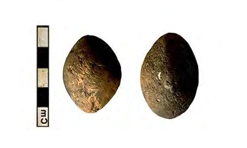
78 1 2 3 Figure 34. Selected finds
79 Metalwork Andrew Hall and Grahame Appleby A total nine pieces of copper alloy (26g), one piece of scrap lead (17g) and 27 pieces of iron (240g) were recovered from the site. With the exception of seven pieces retrieved from archaeological features, all of the other pieces were found during metal detecting. Of the metal detected ironwork assemblage, this consists of hand-made nails (including a large square-headed stud; Cat. No. 1660; length 85.8mm, weight 96g) and a tack or possible hobnail (Cat. No. 1671; 3g). The items are not commented upon further, but are retained in the archive. Ironwork recovered from features is described below. Copper Alloy <1654> F.6188, [20840], Slot Short, cast copper alloy binding strip with three integral rivets (one missing). Length 41.37mm. width 9.9mm, weight 4g. <1655> SF1701; F Heavily corroded copper alloy coin, possibly a Barbarous Radiate of the third century AD. Diameter 17.8mm, weight 4g. <1656> SF1702; F Small coin, heavily corroded nummus, probably fourth century in date. Diameter 13mm, weight 1g. <1657> SF1703; F Small copper alloy coin, of 10.9mm diameter; no surface detail present. Roman or possibly earlier, weight 1g. <1659> SF1705. Small, circular tombak button of c. 17mm diameter, eighteenth-nineteenth century. Diameter 18.4mm, weight 3g. <1663> SF 1700; F.6147 (Fig. 34.3). A complete copper alloy brooch 58 mm in height, made from a single piece of metal. The brooch is an example of a La Tѐne type III Nauhiem Derivative, with a four coil bilateral spring and tapering pin intact if slightly bent. The main body or bow is decorated with a central vertical groove with feint inscribed zigzag within the chamfer. Two further incised vertical lines run parallel to the edges of the bow, meeting in a point just above the footplate, which is solid and undecorated. Of note is the distinctive light green surface patina. This may be a result of a particular metallic composition, such as a high tin content within the alloy. Similar examples have been recorded from across southern Britain (Crummy 1983, 7) with close parallels from Colchester (ibid.) and Saham Toney (Brown 1986). The consensus is that they originate pre-conquest, dying out in the pre-flavian period. <1665> SF1712. A small, circular plain button with traces of gilding, nineteenth century. Diameter 16mm, weight 3g. <1666> SF1713. Heavily worn copper alloy Victoria half-penny, late nineteenth century. Diameter 25.8mm, weight 5g. <1667> SF1714. Nuremberg jetton Hans-Krauwinkel type, dating to the late sixteenth early seventh century. Obverse inscription: HANNS KRAVWINCKEL IN NVR; reverse inscription: GOTES REICH BLIEB. Minted c These have a variety of suggested functions, including use as gaming tokens and on exchequer boards. Diameter 20.7mm, weight 2g. These are common finds, with examples recovered from London and numerous other sites (Egan 2005, 172). Ironwork <1651> F.6023, [20064], slot Complete, delaminating hand-made nail with rectangular, tapering cross-section shank and rectangular shaped cuboid head; length 52.3mm, weight 9g. 75
80 <1652> F.6065, [20294], slot Two items (can crumbs/corrosion products): a) corroded and delaminating bent hand-made nail, missing its tip, with small rectangular(?) cuboid head and rectangular cross-section shank, length c. 56mm, weight 6g; b) heavily corroded and roughly circular cross-sectioned bar or rod, possibly a pin, length 63.5mm, weight 4g. <1653> F.6075, [20371], slot Small, corroded square cross-sectioned rod, probably a nail shank; length 33.6mm, weight 1g. <1675> F.6041, [20119], slot Heavily corroded and concreted fragment of a potentially riveted bracket or fitting with a bar or plate set at right-angles to the bracket; weight 24g. X- ray would aid identification of this item and potential function or use. <4872> F.6183, [21037], slot Fragment of a small very corroded nail, tack or possible hobnail; length 17mm, weight <1g. <4873> F.6233, [21057], slot Corroded and bent shank from a large, square crosssectioned nail or stud; length c. 58mm, weight 24g. Burnt and Worked Clay Simon Timberlake A total of 6.541kg of burnt clay (including 166g from environmental sample residues) and 1.964kg of worked clay was recovered. In addition there was another 2.756kg of vitrified clay (which was originally labelled as slag ). Vitrified clay in this case appears to be the product of the high temperature fusing of daub with fuel ash formed as a result of the intentional or accidental burning of thatch-roofed wood and daub structures (Bayley et al. 2001, 21), most likely being dwellings or granaries. Given that the latter material was originally daub, the total amount of burnt and worked clay recovered from these two sites is actually kg. Amongst (the non-vitrified) burnt clay assemblage was found 0.282kg of daub wall plaster finish and painted (whitewashed) daub, most of it probably being Romano-British in date. Yet another category of burnt clay is the clay oven material, which accounts for a further 4.73kg, the majority of this coming from just one feature (F.6128) associated with Structure 3. Of the 1.964kg of worked clay identified, a minimum of 1.9kg appears to be composed of partial or completely fragmented loomweights. Given its friability it seems possible these may be under-represented in the analysis, and in some cases labelled as wall daub. Better identification of this material has resulted from paying much closer attention to the clay fabrics, in particular through the recognition sometimes of two or more different clay fabric types within the same object i.e. oxidized streaky and gritty clay exteriors (e.g. Fabric 2) combined with a reduced and sometimes visibly organic-rich interior (Fabric 1). Some 15 different burnt clay fabrics were recognized, ranging from variegated streaky mixed-pink and yellow clays with flow lines (e.g. Fabrics 2+3) to the generally much harder pale grey coloured moulded clay used in the construction of loomweights etc. (i.e. Fabric 4). A good number of these may have been made from alluvium mixed with silt and sand derived from the gravels, although the darker fabrics would have included more organic matter and probably charcoal (Fabrics 1 & 14). Although not exactly matching the burnt clay fabrics recovered from Sites II and IV (NWC12), some gross 76
81 similarities were noted between them, and it seems likely therefore that all were locally made. For example, Fabric 3 appeared similar to Fabric 3 (NWC12) and Fabric 5 to Fabric 15 (NWC12), whilst Fabric 4 resembled Fabric 1 (NWC13, Site V) and Fabric 8 resembled Fabric 4 (NWC13, Site V). Fabrics Burnt Fabric 1 Fabric 2 Fabric 3 Fabric 4 Fabric 5 Fabric 6 Fabric 7 Fabric 8 Fabric 9 Fabric 10 Fabric 11 Fabric 12 Fabric 13 Fabric 14 dark grey-black clay fabric hard-crumbly and full of small voids mixed variegated yellow-white to pink clay with flow lines but no inclusions pinkish-red to white or grey fine grain clay daub with some grog and flint inclusions and voids from burnt-out organic (chaff) as well as clay flow lines (NWC12 Fabric 3)) hard light grey fine grained clay fabric with burnt-out chaff and/or small chalk inclusions and a cream grey coloured yellow/buff to pink colour surface patina (NWC13Site V Fabric 1): loomweights? mid to dark grey brown medium coarse lumpy clay with burnt shell, grog and flint inclusions and uneven exterior with light brown to pink patina (NWC12 Fabric 15) hard pale cream-white to slightly pinky grey chalky clay fabric with few voids and no inclusions except for burnt-out sticks a slightly porous but dense sandy chalky clay with few inclusions, some of grit moderately hard pink silty-gritty-sandy clay with some small inclusions of reddish clay grog, occasionally chalk and flint, + minor mica with a porous structure (similar to Fabric 4 NWC13 Site V): daub plaster similar to Fabric 8 but hard-fired, with almost a terracotta fabric in places similar to Fabric 4 but much paler colour internally and with a particular flaky and folded heterogenous structure a slightly conglomeratic lumpy pale cream-light grey coloured clay fabric with chalky grog and much grit as inclusion pinky red to brick red hard tile-like fabric with many small burnt-out voids (chaff?) and slightly grey interior a fine pinkish-brown-grey silty clay fabric without any visible inclusions: clay slingstone fine sandy-gritty buff-dark grey coloured clay with small (<1mm) chalk inclusions and small voids (<2 mm) from burnt-out organic Vitrified Fabric 15 a cream white to light grey coloured lightweight chalky-sandy pumice-like fabric, occasionally with greyer vitrified to sub-glassy textured surfaces coating the larger void areas. Contains 5-10% of inclusions, mostly consisting now of angular calcined flint (10-20mm diameter) but with some less altered burnt flint and small fragments of burnt stone and some softer calcined chalk in places Wattle and Daub (Structural Daub) If one includes all the vitrified clay (Fabric 15) formed out of the highly-fired remnants of wood post- wattle and daub panels dumped from a burnt house, barn or granary fire(s), the material identified here as structural daub is made up of a number of different burnt clay fabric types, principally Fabrics 6, 5 and 12, but possibly others as well. In total this may amount to some 4kg, including material recovered from the environmental residues. Few of the burnt clay daub fragments contain impressions of wattle (just small pieces coming from 77
82 F.6209 and F.6230: typically with <20mm diameter sticks probably of hazel). Fortunately some of the vitrified clay lumps that appear once to have been chalky daub wall(s) (up to mm thick in some pieces e.g. <4482> F.6142) do seem to have preserved the burnt-out traces of wood elements. This includes one example of what was presumably an upright wooden post for a building which measured between mm in the round, plus several examples of split and possibly squared thin timber slats measuring 70 x 30mm, the latter perhaps used as horizontal structural wall elements, and indicative perhaps of Romano- British-style vernacular structures. Most of these pieces with the mould impressions of burnt wood came from F.6142, although two smaller moulds some 30 x 15mm square appear to have been formed from a similar wattle elements present within this vitrified clay from F.6229 and F This is a small but still useful amount of information to have concerning the nature of the wattle and daub wooden buildings on this site, and it might be useful therefore to look again at the individual diameters of small posthole settings which might relate to the presence of dwelling or shelter structures. Moulded Daub Oven or kiln walling? The burnt clay assemblage (4.63kg) from F.6128 appears to be made up of the moulded clay surface and parts of the walling of an oven or kiln, or perhaps the carefully-fashioned surface of a round-edged wall that was broken-up, burnt and dumped (this came from Structure 3 which was interpreted on site as being part of a wall lining ). The minimum wall thickness suggested by these pieces is about 40 60mm, with the possible maximum around the rim being 100mm. Some parts of this (possibly those fragments of the internal face?) were strongly fired. However, there was no evidence within these pieces form any sort of wattle panel to which daub had been applied. For example, only one (15mm diameter) stick impression was seen; this may have been a rim reinforcement for the top of an open structure, or for an arch constructed within an oven or kiln. Just one fragment had some evidence of internal curvature that might have suggested a round or domed structure. Unfortunately, the size of these pieces did not clearly suggest this either way. It was not possible therefore to provide any sort of definitive interpretation of Structure 3 based just on the clay assemblage examined. However, the probability is that this was part of an oven, kiln, or moulded clay (basinal) hearth, rather than just fragments of a daub-lined wall of a dwelling. What is more certain is that this carefully moulded surface had been repaired on several occasions using slightly different clay daub mixes, therefore these fragments were all part of the same structure. The presence of yet other crudely moulded rims within this burnt clay assemblage may also be interpreted as fragments of oven or kiln arch (or alternatively as parts of thinwalled (<40mm) window openings into daub-walled dwellings). This identification of other moulded daub pieces (apart from just worked clay objects) would seem to suggest a more widespread distribution of fragmentary daub wall and oven across the site (e.g. F.6104). Daub Wall Plasters and Painted Daub The daub plasters consisted of various pieces of burnt clay just 25-30mm thick which were both compact as well as flat, having the appearance of wall or floor plaster (e.g. Fabrics 7, 8 + 9) in a style rather similar to that encountered within later Roman buildings (where these would have been fabricated instead out of a formula-type lime plaster recipe such as opus caementicum and terra sigillata). For example, there is at least one example of a white painted (whitewashed) coated fragment of a daub plaster-finished fragment of walling from F.6081 [20755] (<1308> see Figure ). In all probability then we are looking at a Romano-British vernacular style which may have involved keying and pargeting daub, laying a daub skim on top, followed by limewashing or painting. In terms of other local examples, something similar was noted recently at Northstowe (Site E), where the use of a painted daub plaster was found associated with early Conquest Period Romano-British structures (see Timberlake 2014). Whilst not necessarily an uncommon practice, there seems to be few detailed references to the use of this technique in Roman Britain, although Wallace (2014, p.85) does refer to the use of keyed daub in association with Roman painted plaster (though not painted daub) at Ludgate Hill Road, Cornhill, London, and there are likewise numerous brief references to the practice of limewashing or painting daub walls in lower status Roman houses (see Bishop 2012, 40; Perring 2014). 78
83 Clay Loomweights The clay loomweight fragments from this site represent a minimum recovery of at least three flat-triangular shape (Fabric Types 1 2) loomweights (the latter consisting of two partial to nearly complete examples plus fragments from several others) alongside other pieces from a maximum of eight (but a minimum of 2-3) smaller rectangular to pyramidal-triangular shaped loomweights (Fabric 4). These latter forms are probably similar to the rather more complete examples found during the nearby excavations at NW Cambridge Prehistoric Sites 1 and 2 in 2012 (see Timberlake 2012). These objects therefore resemble Late Bronze Age - Iron Age and particularly earlier Iron Age loomweight types, with other similar local examples being described from Wardy Hill, Cambridgeshire (Gdaniec & Lucas in Evans 2003, 194 & fig. 93), and closer still from High Cross, West Cambridge (see Timberlake 2010). Given that these objects appear to be variants of what are after all generically common forms typical of the Late Bronze Age Early/Middle Iron Age, there is some justification in claiming that these loomweight designs are also inherently conservative and much longer-lived, with suggestions for instance that their use continued into the Late Iron Age and the Roman period (see Lambrick 2010 re. fired clay loomweights from Mounts Farm, Dorchester). The occurrence of scoring upon the moulded clay surface of just one of these pieces (see catalogue below for <4811> F.6267) has been noted elsewhere, and is interesting also in the context of the wavy tooth comb impressions found upon the cylindrical loomweights from Latton Lands, Dorset which was matched to that found on associated Middle Bronze Age Deveril- Rimbury pottery (see Edwards in Stansbie & Laws 2004, ). The better preserved examples of flat triangular fired clay loomweights from the site form an altogether better match with what are commonly referred to as typical Iron Age equilateral triangular loomweight types (Lambrick 2010), though similarly it was noted that these forms are sometimes found also within Romano-British features, suggesting that they either survived redeposition, or more likely continued in use into the Early Roman period (Lambrick & Allen 2004, 343, 400). Another relevant issue currently in discussion amongst fired clay specialists is whether or not these moulded perforated objects assumed to be loomweights might in fact be several different objects, with a variety use functions represented (Wild 2003, 3). For instance, in volume 6 of Cunliffe s Danebury series, Poole demonstrated reasonable doubt as to the function of triangular, pierced clay objects (Poole 1995, 285 6), and furthermore provided the results of research (based on a number of large assemblages throughout the southwest) which suggested a tendency for such objects to be associated with oven structure, daub and clay rather than with other textile related objects. Poole made a distinction between chalk and clay triangular objects; use wear of a sort consistent with that expected on a loomweight is often observed on the former, but rarely on the latter. This remains a conundum in terms of the current assemblage, since both oven material and a supposed loomweight occur within reasonably close proximity to one another. Nevertheless, some of the perforations examined did show signs of wear (i.e. the smooth and round cone-shaped aperture seen at one end of the perforation in the rectangular triangular loomweight fragment <4547> from F.6082), whilst others didn t (i.e. the fresh-looking perforation(s) seen penetrating the corners of the equilateral triangular (Iron Age) loomweight <4848> recovered from F.6137). On balance therefore it seems prudent to assume that these objects are in fact loomweights, with the proviso that a good many of these (sometimes friable) moulded fired clay pieces broke either before, or else during, the early stages of their use. The occurrence of loomweight at this site doesn t appear to be that high, but is in fact moderately abundant, with particular associations of material coming from Features 6079, 6080, 6082, 6134, 6137, 6262 and The incidence for the use of this loomweight may accord with the evidence for the processing of sheep on site. Clay Slingstones Two carefully-moulded and more or less undamaged (possibly unused?) oval-shaped baked clay slingstones were recovered from F.6128, [20528] (Fig. 34.1); the same feature associated with Structure 3 and the broken-up clay walling of the potential oven or kiln (see above). Though found together, both objects had been moulded out of quite different clay fabrics (i.e. Fabrics 13 & 14). Of the two slingstones, <1400a> was the more rounded and rugby ball 79
84 shaped projectile (dimensions 40mm long x 30mm in diameter: weight 26g), with <1400b> being the more elongated projectile type with a more round-square rather than circular x- sectional profile (dimensions 45 x 24mm: weight 28g). Their shape compares well with the single example of a clay slingstone recovered from Ham Hill in 2013, though the latter was a little smaller (i.e. 35 x 22mm) and weighed just 16g (Timberlake 2013). It might be noted that this Ham Hill example in many respects conformed to the size/weight category of stone slingshot form this Late Iron Age hillfort. Moulded clay slingstones are sufficiently rare to warrant some sort of mention when they are found. This is particularly the case where these occur outside of a hillfort or other large Late Iron Age defended settlement setting. Cunliffe (2006, 489) refers to the rare occurrence of clay slingstone amongst stone slingshot at Danebury, whilst a single example was also found at Poundbury (Ancient Monument Lab Report No. 4148). The Poundbury clay slingstone was thin-sectioned and then compared to examples made experimentally from clays dug on the hillfort, thus shown to be of local manufacture. A recent study of slingstones used in Late Iron Age warfare has similarly documented the occurrence of clay slingstone alongside stone, and has also looked at the consistency in their form (Finney 2005). More interesting and relevant perhaps to the occurrence of these clay slingstones within the Iron Age settlement at North West Cambridge are ideas regarding their use in small game hunting. The occurrence of clay slingstones during the Late Iron Age at the Glastonbury Lake Village was noted by McIntosh (2006, 149) as having possible associations with wildfowl hunting, as was also observed by Harding (2012, 195) who commented on their increased (but still rare) occurrence at nonhillfort settlements, where softer slingshot might be more preferable in non-mortal combat, and particularly when hunting small animals. Unfortunately, such an assumption does not really hold, since stone slingshot far outnumbers clay slingstone at similarly dated settings such as at Meare Lake Village. Equally there was no particular advantage to manufacturing projectiles from clay when stone slingshot was being transported in very large amounts over significant distances to the various points of use (as was the case with Danebury, Maiden Castle and Ham Hill forts and with numerous other examples (see Timberlake 2013). The apparent ready availability of flint gravel at North West Cambridge from which to choose suitably sized small pebbles for use as slingshot likewise doesn t really explain the necessity for its manufacture from clay. Nevertheless, wherever it does occur the ( rugby ball ) shape of moulded baked clay slingstone really is distinctive, and one can only assume therefore that this particular shape has distinct aerodynamic advantages when used as a sling projectile (see Finney 2005). Cat. no Site Feature Context/ enviro no Wt. (g) Nos. pieces Fabric type Inclusions WC? Notes 1108 E E residue <902> 1698 E residue <903> 1161 E E E E residue <940> 1235 E smooth textured exterior 1859 E residue <962> 1265a E TD organic c. 40% of a split flat +burnt out triangular loomweight; grass similar to <4848>) with two warp perforation holes across each protrude corner (sides 130mm + orig height c.50-60mm) Tapers in downwards 1828 E residue <951> 4519a+b TD incl large piece (Fabric 4) may be 80
85 1804 E <944> WC? part of side of loomweight? residue 1308 E flat external surface with daub plaster attached? 1309 E E <908> residue 4539 TD TD hard fired with chalk + red clay grog incl + b o straw 4556 TD similar to <4547> WC WC? corner of loomweight outer surface with angular + cone- shape warp thread perforation (10-15mm diam ext) loomweight frags incl poss base (non- diagnost) ; part of <4547>? 1332 E E residue <939> 1726 E ? residue <913> 1377 E WC? like<1519>shows evidence of moulding non- diagnostic fragment from loomweight? 1379 E part of rim of daub panel? 1396 E > chalk + calcined flint (<10mm) + calcined bone (<20mm) + grog (<10mm) + organic? large broken assemblage with moulded round extern surface pieces (Fabric 6) and lumpy internal (Fabric 11), and also v well- fired pieces (Fabric 9). Evidence for repair of original walling, with re- cemented surface pieces. Probable thickness 40-60mm. Could be part of an oven, but poss wall? Structure3 1400a+b E WC x2 complete ovoid (rugby ball shaped) clay slingstones: (a) 40 x 30mm (26g); (b) 45 x 24mm (28g) 1730 E <914> 4569 TD organic WC? poss one side of a rough- moulded loomweight (i.e. v.similar to <4556>) 4848 TD organic fine WC 50-60% of a flat triangular charcoal + edge- perforat loomweight plant material ( mm sides) with 3 warp thread holes (20-12mm diam) 1456 E E <904> 1464 E BS also 1474 E E residue <959> 1797 E residue <943> 1519 E WC? fingerprints on one side a non- diagnostic fragment 81
86 from loomweight? 1537 E E fingerprints on one side 1546 E grit v flat and smooth extern surface suggests floor plaster or wall 4623 TD TD E residue <906> 1766 E residue <928> 4659 TD TD sand and painted daub plaster with red clay remnant whitewash well fired 4682 TD ? WC? possibly small frag flat surface of loomweight? 1770 E residue <934> 1811 E <947> 4 3 residue 1644 E TD TD E stick (wattle impressions in 2d) - daub walling 4709 TD TD TD stick impression? 4756 TD TD WC moulded round corner with trace of angular warp thread perforation: small frag triangular- rectangular loomweight 4811 TD WC moulded round corner of a loomweight? with lightly scored surface and reduced grey with stick impress NOT perfor 1864 E 6301 <963> env grit residue Table 23: Catalogue of Fired Clay. Cat. no Site Feature Context/ enviro no Wt. (g) Nos. pieces Fabric type inclusions WC? Notes 1177 E F glassy frothy + composed of a v fused chalky flinty clay 4520 TD F TD F TD F calc flint 4552 TD F E F fused glassy chalky flinty daub 4852 TD F calcined flint <20mm diam at least 4 large pieces (largest 130mm) have semi- cylindrical voids suggesting burnt out timber incl an upright(?) roundwood post of c mm diameter + 82
87 x3 squared wooden ends c. 70 x 30mm 4615 TD F TD F E F includes large lumps of calcined flint 4653 TD F E F rather more eroded lump of frothy v c 4690 E F burnt chalk + calc flint 4724 TD F calcined flint + BS 4721 TD F BF + cal flint poss wood impression in one (30 x 15mm) 4751 TD F poss wattle? void of c.15mm 4798 TD F BF Table 24: Catalogue of Vitrified Clay. Tile Grahame Appleby Some 14 fragments of tile (173g) were recovered during excavation, including one surface find from Late Iron Age ditch F With the exception of three pieces, the fragments consist of thin, buff pieces (c mm thickness) with evident oxidation. Of the remaining orange (oxidised) fragments, two are of a similar thickness to the pieces described above, the third piece measuring c. 16mm thick. This last piece, from furrow F.6283, has mortar adhering to one edge and may be Medieval or later in origin. Three pieces from post-medieval pit F.6041 may also be later, although all these fragments, due to their small size, may be residual. Cat. No. Slag Simon Timberlake Just 190g of iron slag was recovered, consisting of two small and quite weathered lumps of dense iron slag and one possible fragment of vitrified hearth lining, the latter with some evidence of secondary use. One of the small dense slag pieces is clearly part of a small smithing hearth base (SHB) associated with forging, whilst the other slag lump which includes some denser slag runnel is perhaps from smithing activity, but also may be from iron smelting (see Bayley et al. 2001). Both pieces show significant evidence of weathering and abrasion, suggesting that the ironworking activity was not immediately local to this part of the site. Feature/ context/ site No. piece Weight (g) Magnetic (scale 0 >4) Iron smith slag Fe concretion (N= natural, F=fuel ash S?= smith) 1372 F.6103 [6103] ? fused glassy VHL with remnant of flint and chalk inclus possibly x2 relining 1421 F.6133 [20934] N nat concretion with iron oxide 1479 F.6147 [20747] Y SSL moderately weathered piece 4656 F.6198 [21382] ? iron smelting or smithing slag v weathered Table 25: Slag Pieces. Notes 83
88 Worked Stone Simon Timberlake Some 27kg of worked stone was recovered. Of this, 22.16kg consisted of rotary (hand mill) quern, 3.228kg of saddlequern and rubbing stone, hammerstone 0.816kg, anvil stone 0.654kg and stone spindlewhorl just 0.128kg. Hammerstone <4799> F.6263 Sl [21280]. A flattened-oval shaped weathered and frost-pitted cobble of micaceous quartzitic sandstone with a burnt reddened external patina which appears subsequently to have been used opportunistically for a very short time as a hammerstone. This has been broken (i.e. usewear flaked) at both ends, one end having a small (i.e. 20mm diam) area of pounding/pitting associated with it. There are also two pitted areas immediately opposite each other on the long sides which suggests notching for what could have been a withy handle, and on the corresponding part of the edge some bruising/ minor flaking, perhaps for the same. Dimensions: 150 x 60 x 70mm; weight 816g. Anvil Stone <1405> F.6129 Sl.4102 [20530]. x2 adjoining edge pieces of small saddlequern (?) used as anvil. Original dimensions: 100 x 100 x 40-45mm; combined weight pieces 654g. Possesses one smooth worked surface with indentation (<5mm). Spindlewhorl <1575> F.6189 Sl.4153 [20842]. Possibly a partly-worked stone blank disc for an (unfinished) spindlewhorl. Made of fissile micaceous sandstone crudely chipped around the edges to a disc shape (75mm in diameter). A very small hole (2-3mm diameter and 1.5mm deep) has been pecked out in the exact centre of the worked (pecked) side of this stone, but has not perforated it. Dimensions: x 10-15mm (thick); weight128g. Quernstone Saddlequern <4826> F.6290 Sl.4260 [21467]. A small fragment from the edge of a thin fine-grained sandstone saddlequern with a well worn/ polished grinding surface (60 x 60mm). Dimensions: 60 x x 25mm; weight 182g. <4525> F.6080 Sl.4245 [21410]. Fragment of a thin slab saddlequern made of a flat boulder of flaggy slightly micaceous sandstone (Greensand?). The top shows signs of having been dressed to a flat surface through extensive pecking, yet has also experienced a moderate amount of quern use with some areas of polish (grinding surface up to 173 sq cm). One of the edges of the slab has been roughly shaped. Dimensions: 200 x 150 x 35-45mm (middle); 1410 g. <4828> F.6291 Sl.4260 [21470]. Edge fragment of thin slab boulder saddlequern which shows signs of having been worked (shaped) around edge, also fair amount of wear polish on grinding surface (80mmx40mm grinding area). Dimensions: 90 x 70 x 40mm; weight 288g. <4548> F.6082 Sl.4073 [21046]. Possibly an edge fragment of a small slab saddlequern. Shaped around rim on one side? Grinding area 1600sqmm. Dimensions: 80 x 50 x 50mm; weight 216g. <4691> c F.6205 Sl.4691 [20920]. Edge of a small, worn, boulder slab saddlequern (grinding area = 4200 sq mm) with flat horiz planar well-polished and strongly patinated grinding surface. Edges of squarish slab are naturally rounded. Rock seems to be a metasandstone, perhaps an ORS. Dimensions: 85 x 80 x 45mm; weight 594g. Rubbing Stone <4661> F.6198 Sl.4260 [21476]. Small, flat well-polished rubbing stone made from a small pebble slab of pinkish quartzite. Grinding surface is fairly homogenous (70 x 95mm grinding area). Dimensions: 70 x 100 x 22mm; weight 332g. 84
89 <4747b> F.6236 Sl.4207 [2117]. x2 halves of small rubbing stone. Dimensions: 80 x 60 x 20mm; weight 204g. Oval-triangular shaped small flat slab. Arkosic Palaeozoic Precambrian? Flat to slight convex grinding wear surface. Grinding wear area 3850sqmm. Weight 206g. Rotary Quern <1575> F.6189 Sl.4153 [20842]. Rim fragment from (probably) the upper stone of a flat-topped rotary quern (Type 2 (Shaffrey 2006)) made from a medium-grained non-conglomeratic Millstone Grit. The top surface has been dressed using a spaced pecking pattern, whilst the lower grinding surface is fairly worn and polished from wear, and also slightly sloping /concave in profile. Suggested original size of stone 35mm diameter; weight 654g. <1578> F.6190 Sl.4153 [20844]. Non-diagnostic rounded fragments of Niedermendig lava quern formed from the weathering of worn and discarded pieces. 10+ small fragments; weight 186g. <1585> F.6190 Sl.4153 [20846]. An eroded fragment from the edge of a fairly coarse-grained Millstone Grit flat-topped quern (upper stone?). The grinding surface is not particularly worn, at least traces of the spaced pecking pattern dressing on the grinding surface is still visible. Dimensions: 150 x 95 x 55mm; weight 942g. <1204> F.6064 Sl.4055 [20195]. A fragment detached from close to the rim of an upper stone of a puddingstone-type Early Roman rotary quern. Typically this is made of Hertfordshire Puddingstone conglomerate (Tertiary), the curvature present on the flat bottom grinding surface suggesting a diameter of circa. 250mm. Dimensions of piece: 70 x 30 x 60mm; weight 146g. <1210> F.6272 Sl.4063 [20261]. Small basal rim fragment detached from the upper stone of a Hunsbury Late Iron Age-Early Roman rotary quern hand mill, perhaps of the Folkestone type (Keller 1989). This may be a detached fragment from one of the more complete rotary quern stones recovered from F.6263 (i.e.<4807>). There are suggestions in this piece of a shaped side and flat base. Made of a coarse gritty Lower Greensand such as was quarried at East Wear bay, Folkestone (Kent). Dimensions: 80 x 40 x 40mm; weight 198g. <4806 a > F.6263 (Fig. 28; Sl. 4159, [21504]). Approximately 30-40% of an upper stone of a Hunsbury Early Roman rotary quern hand mill, probably of the Folkestone type (see Keller 1989) quarried at East Wear Bay, Folkestone. This has a typically flat and moderately wellworn grinding surface with traces of the pecked dressing surface still visible. The original diameter of this stone (and hence the rotary hand mill) would have been around 270mm, with a typically narrow spindle hole at the base of this stone of around 34mm. This evidently narrows further some 60mm into the stone, the actual grain feed eye being missing altogether due to breakage. One interesting feature of this and quern stone <4807> is the presence of a sloping picked groove (20-40mm wide and 2-4mm deep declining at an angle of about 10 ) around the outer circumference. This may have been added as a consequence of the acentric orientation and wear which has been noted in some Hunsbury type Iron Age querns (see Curwen 1941, 17, Figs 1 & 3). Almost certainly this was not a feature of its manufacture, but possibly instead as a result of the failure of its wooden handle/ socket. Dimensions: 250mm diameter x 170mm tall x 150mm thick; weight > 5kg. <4806 b> F.6263 (Fig. 28; Sl.4159, [21504]). Approximately 45-50% of the upper stone of a Hunsbury Early Roman rotary quern hand mill, probably of the Folkestone type (see Keller 1989), similar to the above. The grinding surface is smooth, flat, and slightly concave, with only the small rounded flint grit clasts proud of the surface of the sandstone. The axle hole is slightly declined (i.e. at 85 rather than 90 to the horizontal grinding plane) and is coneshaped with a wide funnel-like grain-feed eye at the top (of between mm diameter) narrowing to the spindle hole of around 20mm diameter at the base. The wear on this suggests a slightly acentric motion (or wobble) during grinding. The broken section reveals the presence of a wooden handle hole which penetrates the central axle shaft a quite typical feature in Hunsbury querns. A good analogy for this type can be seen in Curwen ibid. Figure 2. The handle hole is c. 90mm deep by 17-30mm wide, suggesting the use of a slightly triangular-shaped peg. Manufacture from this Folkestone Greensand source dates the quern to the first century BC first century AD. Dimensions: 275 x 160mm high; weight > 5kg. 85
90 <4807> F.6263 Fig. 28; Sl.4159, [21283]). Approx % of the upper stone of a Hunsbury Early Roman rotary quern hand mill, probably of the Folkestone type (see Keller 1989), similar to the above. The stone has been burnt, and thus is heavily cracked and sooted towards the top, the form of this suggesting that the stone was whole and useable prior to it being affected by fire. Originally of a similar diameter (i.e. 280mm) but probably taller (i.e. 220mm) than either <4806 a+b>, this example is characteristic of the type with two opposing handle holes, both penetrating the central the central funnel-shaped conical eye and axle hole (100 x 20mm diameter). A comparison may be made with the Hunsbury querns from Thurmaston, Leicester (Leicester Museum) and Northampton Museum illustrated in Curwen 1941 (17, figs 3 & 11). The presence of two handles has been suggested as an argument for this being used two-handled with a push-pull action indicating oscillatory rather than truly rotational movement in milling (Watts 2002). Just as interesting here is a further modification in the form of an angled pecked-out groove around the middle circumference of the stone (as also in <4806a>). This is suggested by Watts (ibid. 32) as a modification more typical of the East Anglian type ( Puddingstone ) querns, here being adopted for use in the cross-over Folkestone form, transgressing both spheres of influence through trade connections as well as the transferral of ideas. In this case it seems likely that an iron band was attached to the exterior of the stone as a repair or modification following the failure of the handles (either through wear of the holes or breakage). The angle of the central spindle hole to the flat grinding face perhaps explains the reason for the angle of the groove; the grinding face of the lower or basal stone was either cut to, or had worn down to, an angle of about 25. The grinding surface of this stone exhibits a moderate amount of wear, but has remained perfectly flat. Traces of the last dressing of this stone (in the form of a pecking pattern) are still visible. Burnt Stone Simon Timberlake A total of kg of burnt and broken stone (consisting of 246 complete or fragmentary cobbles) was recovered from the excavations; almost half of which consisted of large (>100mm diameter) cobbles, the largest amounts of which were recovered from feature(s) F.6236 (14.72kg), F.6205 (12.05kg), F.6263 (10.084kg), F.6152 (8.056kg) and F.6076 (5.986kg). All of this burnt stone was recovered from confirmed features/ contexts, with very little of this (<4%) being discarded and recycled worked stone (i.e. broken and burnt saddlequern etc.) such as has been found at a number of other near-cambridge Early-Middle Iron Age settlements such as Trumpington Meadows (Patten 2012) and Barleycroft Farm (Evans & Tabor 2012). The large size of the burnt cobbles and the occurrence of incipient cracking within some of the finer-grained lithologies suggests the selection and use of these as large potboilers for cooking within clay-lined or impervious hearth basins in water; in other words, a phenomena typical of the earlier Iron Age such as we find at the Broom EIA-MIA settlement near Sandy in Bedfordshire (see Slater 2008) yet persisting into the Late Iron Age in other places. Almost exclusively at these sites we find the selection of large sarsen (quartzitic or quartz-cemented sandstone) cobbles/small boulders for this purpose, with only minor evidence for the use of the denser but generally more suitable igneous rock cobbles such as dolerite. Interestingly, we find certain similarities between the current site and the distribution/ occurrence of burnt stone within the adjacent North West Cambridge Sites II and IV excavated in 2012 (see Timberlake in Cessford & Evans 2014). At the latter, 82% of the stone consists of large fragments/cobbles of sandstone/sarsen, most of which came from the fill of the Romano-British enclosure ditch, almost certainly as redeposited material. 86
91 Cat. No. Feature/ SF/ enviro <> Slot Context Nos frags Size (mm) Weight (g) Geology x90x quartzitic sandstone grit x95x x80x x70x x80x x80x x145x x120x x90x x95x x95x x55x x40x40 ) 30x30x fine gr grey quartz sstn + medium gr orthoquartz sstn 2186 qtzitic micac sstn (sarsen) + micac sstn (2) + micac sstn (Greensand) + dolerite 7122 dolerite + dense sstn (2) + metasandstone/ quartzite 778 basalt + quartzite + qtzit sstn + decalcify lmstn/chert x60x dolerite + volc tuff 70x35x x45x micac lamin sstn (greensand?) x40x25 94 metaquartzite (Bunter?) x35x15 20 quartzitic sstn Notes x1 edge of saddlequern (>WS) x1 peck hammers? (> WS) cracked pebble x25x20 38 sstn x80x x70x micac qtz sstn + dense med gr sstn (Mesozoic) x65x Fe-rich sstn adj frags,;reduced x90x sl micac qtz sstn x60x soft sstn + qtzitic sstn x165x b largest 150x120x12 0 smallest 40x30x quartz schist (Dalradian Scotland?) 9966 micac quartzite + orthoquartz sstn + sarsen cobble + fossil sstn + greensand + fossilif quartzit sstn + metasandstone (Torridonian?) x25x8 10 spherulitic rhyolite? boulder incl rubbing stone (>WS) coarse sstn x70x micac flaggy sstn largest 40x30x20 80 pale orthoquartz fine gr sstn x80x fine gr micac sstn x15x10 6 fine qtz sstn 87
92 x25x15 18 carstone (LGS) x45x20 72 decalcif sstn 4691a x90x fine gr micac sstn + fine gr grey sstn (4) + micac flaggy sstn + micac qtz sstn + dolomit grit sstn + quartzite sstn + meta quartzite (Bunter) 4691 b largest 100x60x35 smallest 50x35x med grey micac qtz sstn (5) + quartz sstn (4) + pale ganister sstn (fossil rootlet) 4691c x80x micac quartzite + micac flaggy sstn + pale hard sstn (greensand) + yellow ssstn + metasandstone? x80x micac siltstone/ fine gr sstn largest 155x150x80 smallest 60x60x granodiorite + red metasandstone + metaquartzite x100x hard sl micac sstn (greensand?) 1of 3 2 of 3 3 of 3 incl part saddlequern (>WS) x70x x80x dense ferrug sstn (3) + pale med gr quartz sstn + pinkish micac qtz sstn mm diam 76 round flint nodule poss not burnt? x90x pale quartzitic sstn sstn x60x coarse sstn+ fine gr micac soft sstn + ferrug sstn x110x dolerite boulder + micac sstn x90x quartzite sarsen x30x4 14 fine gr sstn x165x fine gr grey sstn boulder x145x fine gr grey sstn boulder x100x x50x largest 110x75x65 smallest 70x50x x90x x90x (x3) x70x x55x x50x micaceous sstn + decalcif micac sstn 1262 coarse and med gr qtz sstns 1892 grey fine-med sstn + white sstn + fossilif micac sstn +Palaeoz. greywacke grit? + Bunter? metaquartzite 1394 dolerite? + fine grained laminmicac sstn + quartzit sstn/ siltstn 88
93 x60x v coarse grain orthoquartzite x70x decalcif fossilif sstn + metaquartzite x70x x55x silicified quartzite/ metasandstone x60x white-light grey sstn x100x x75x x70x flaggy micac grey quartzitic sstn + qtzit siltstone x70x flaggy micac quartz sstn (sarsen) x70x soft lithic sstn grit (LGS?) x42x30 50 decalcif sstn (greensand?) x30x pale soft sstn + dolomit sstn largest 110x55x40 smallest 60x35x largest 190x75x45 smallest 90x85x lithic metasandstone (ORS Devonian?)(2) + micac sstn (2) 1986 volcanic tuff + micac sstn (2) x2 adj piece anvil stone (>WS) x35x30 88 micac med gr sstn <1722> x55x x65x50+ 85x45x x35x30 92 BF 1224 fine grn qtz-lithic sstn + med gr qtz sstn sarsen + clastic breccia x85x quartzitic med g sstn (sarsen) x70x micac qtz sstn (sarsen) x45x micac fossilif sstn (Mesozoic) + volcanic tuff (Palaeozoic) x65x silicified sstn (sarsen) edge of poss saddlequern (>WS) x55x dolerite x50x metasandstone Devonian ORS? x65x tourmalinized fractured qtz veined microgranite (SW England Cornwall?) + micac fine gr sstn + micac fossilif sstn x445x micac sstn x20x12 10 black sst with mafic minerals x150x x90x x70x x90x (x3) 1410 flaggy micac sandston (greensand) 2632 rhyolitic tuff + quartzit micac sstn (x3) + dense sstn (x2) saddlequern?(>ws) slab saddlequern (> WS) 89
94 largest 90x80x40 smallest 75x65x flaggy micac sstn(2) + qtz sstn x60x fine qtz sstn w foss pl (Jur Est Ser?) x45x20 68 fine qtz siltstone wit foss pl sstn 1266a x135x b largest 130x90x50 smallest 75x55x fine quartzitic siltstone/ sandstone with plant foss (M.Jurass Estuarine Series?) 1774 dolomitised decalif calc fossil sstn + qutz siltstn +chert + sstn x50x dolerite/ microdiorite x60x x largest 90x70x flaggy micac sstn 512 soft micac sstn + decalcif sstn x70x silicif quartzite with plant foss (Jur Est Ser?) x40x25 60 micaceous siltstn/sstn x105x hard med gr sstn + mic qtz sstn <903> sstn >4mm largest 100x60x60 smallest 35x25x metaquartzite (Bunter?) (4)+ quartzite + sstn (sarsen) x80x fine gr brown quartzitic sstn Table 26: Burnt Stone Catalogue. heat-cracked small cobbles Environmental and Economic Data Although not fully report herein, an insect sample from Roman-phase well F.6263 was studied by David Smith (University of Birmingham) and who reports: As was the case with the insect faunas that were recovered from the Roman wells excavated at North West Cambridge in 2012 (Smith 2014), the majority of the terrestrial species of beetle recovered are indicators for the presence of pasture and grassland. Geotrupes, Onthophagus and Aphodius dung beetles. These account for a relatively large proportion, at least 20%, of the terrestrial fauna recovered suggesting that substantial pasture existed in the area (see Whitehouse & Smith 2010; Smith et al. 2012, 2014). Many of the plant feeding species of beetle recovered commonly occur in grassland. These include a range of Sitona clover weevils, the weevil Ceutorhynchus eryisimi, which is associated Shepherd s purse (Capsella bursa-pastoris (L.) Medik.), and Ceutorhynchus troglodytes and Mecinus pyraster which are both associated with plantains (Plantago spp.; Morris 2008). Many of the carabid ground beetles recovered also are associated with open grassland, farmland and waste areas; for example Nebria brevicollis, Notiophilus biguttatus, Clivina fossor, Bembidion lampros, B. guttula, Pterostichus melanarius, Calathus 90
95 fuscipes, C. melanocephalus, Platynus dorsalis, Amara aenea, A. bifrons (Luff 2007). Perhaps the best indicator for grassland is the recovery two species of chaffer, Phyllopertha horticola and Hoplia philanthus (Jessop 1986). Like the Romano-British wells encountered in the 2012 excavations, these wells produced few indicators for the presence of woodland, except for the odd individual of the woodworm Anobium punctatum, suggesting that the landscape in this area essentially was cleared of woodland throughout the period of time represented by these deposits. Animal Bone Lorraine Higbee (Wessex Archaeology) This report details the results of an assessment of the site s animal bone assemblage. The total assemblage comprises 5398 fragments (70.821kg) of animal bone; however once conjoins are taken into account this falls to 2710 fragments. Most (99.6% by weight) of the animal bone was recovered by hand during the normal course of excavation and the remainder was retrieved from the sieved residues of 40 bulk soil samples. The assemblage includes material of Iron Age and Romano-British date (Table 27), and comes from a range of feature types including enclosure ditches, roundhouse structures and pits. The assemblage was assessed by rapid scanning and quantified in terms of the number of identified specimens present (or NISP). Complete and partial skeletons were counted as one specimen each. Notes were also made about the preservation condition and skeletal element representation of bones from individual contexts and/or features. Information such as fusion and tooth ageing data, butchery marks, metrical data, pathology and non-metric traits was quantified but not recorded in detail. This information was directly recorded into a spreadsheet and cross-referenced with relevant contextual information. Species IA RB Total cattle sheep/goat pig horse dog red deer 1 1 hare 1 1 polecat 1 1 domestic fowl 2 2 duck 1 1 fish 1 1 anura Total identified large mammal medium mammal small mammal mammal Total unidentifiable Overall total Table 27: Number of identified specimens present (or NISP). 91


96 Figure 35. Animal carcasses: top, articulated dog skeleton parts in Iron Age ditch F.6056; below, pig in Roman ditch F.6102


97 Filleting marks on neck and around origin of spine on horse scapula from F6134 Filleting marks on medial side of horse scapula blade from F6134 Figure 36. Horse butchery
An archaeological evaluation at the Lexden Wood Golf Club (Westhouse Farm), Lexden, Colchester, Essex
, Lexden, Colchester, Essex") An archaeological evaluation at the Lexden Wood Golf Club (Westhouse Farm), Lexden, Colchester, Essex January 2000 Archive report on behalf of Lexden Wood Golf Club Colchester Archaeological Trust 12 Lexden
An archaeological evaluation at the Lexden Wood Golf Club (Westhouse Farm), Lexden, Colchester, Essex January 2000 Archive report on behalf of Lexden Wood Golf Club Colchester Archaeological Trust 12 Lexden
39, Walnut Tree Lane, Sudbury (SUY 073) Planning Application No. B/04/02019/FUL Archaeological Monitoring Report No. 2005/112 OASIS ID no.
 Planning Application No. B/04/02019/FUL Archaeological Monitoring Report No. 2005/112 OASIS ID no.") 39, Walnut Tree Lane, Sudbury (SUY 073) Planning Application No. B/04/02019/FUL Archaeological Monitoring Report No. 2005/112 OASIS ID no. 9273 Summary Sudbury, 39, Walnut Tree Lane, Sudbury (TL/869412;
39, Walnut Tree Lane, Sudbury (SUY 073) Planning Application No. B/04/02019/FUL Archaeological Monitoring Report No. 2005/112 OASIS ID no. 9273 Summary Sudbury, 39, Walnut Tree Lane, Sudbury (TL/869412;
ARCHAEOLOGICAL EVALUATION AT BRIGHTON POLYTECHNIC, NORTH FIELD SITE, VARLEY HALLS, COLDEAN LANE, BRIGHTON. by Ian Greig MA AIFA.
 ARCHAEOLOGICAL EVALUATION AT BRIGHTON POLYTECHNIC, NORTH FIELD SITE, VARLEY HALLS, COLDEAN LANE, BRIGHTON by Ian Greig MA AIFA May 1992 South Eastern Archaeological Services Field Archaeology Unit White
Colchester Archaeological Trust Ltd. A Fieldwalking Survey at Birch, Colchester for ARC Southern Ltd
 Colchester Archaeological Trust Ltd A Fieldwalking Survey at Birch, Colchester for ARC Southern Ltd November 1997 CONTENTS page Summary... 1 Background... 1 Methods... 1 Retrieval Policy... 2 Conditions...
An archaeological evaluation at 16 Seaview Road, Brightlingsea, Essex February 2004
 An archaeological evaluation at 16 Seaview Road, Brightlingsea, Essex February 2004 report prepared by Kate Orr on behalf of Highfield Homes NGR: TM 086 174 (c) CAT project ref.: 04/2b ECC HAMP group site
Fieldwalking at Cottam 1994 (COT94F)
") Fieldwalking at Cottam 1994 (COT94F) Tony Austin & Elizabeth Jelley (19 Jan 29) 1. Introduction During the winter of 1994 students from the Department of Archaeology at the University of York undertook
Fieldwalking at Cottam 1994 (COT94F) Tony Austin & Elizabeth Jelley (19 Jan 29) 1. Introduction During the winter of 1994 students from the Department of Archaeology at the University of York undertook
Grim s Ditch, Starveall Farm, Wootton, Woodstock, Oxfordshire
 Grim s Ditch, Starveall Farm, Wootton, Woodstock, Oxfordshire An Archaeological Recording Action For Empire Homes by Steve Ford Thames Valley Archaeological Services Ltd Site Code SFW06/118 November 2006
Cambridge Archaeology Field Group. Fieldwalking on the Childerley Estate, Cambridgeshire. Autumn 2014 to Spring Third interim report
 Cambridge Archaeology Field Group Fieldwalking on the Childerley Estate, Cambridgeshire Autumn 2014 to Spring 2015 Third interim report Summary Field walking on the Childerley estate of Martin Jenkins
7. Prehistoric features and an early medieval enclosure at Coonagh West, Co. Limerick Kate Taylor
 7. Prehistoric features and an early medieval enclosure at Coonagh West, Co. Limerick Kate Taylor Illus. 1 Location of the site in Coonagh West, Co. Limerick (based on the Ordnance Survey Ireland map)
Greater London GREATER LONDON 3/606 (E ) TQ
 TQ") GREATER LONDON City of London 3/606 (E.01.6024) TQ 30358150 1 PLOUGH PLACE, CITY OF LONDON An Archaeological Watching Brief at 1 Plough Place, City of London, London EC4 Butler, J London : Pre-Construct
GREATER LONDON City of London 3/606 (E.01.6024) TQ 30358150 1 PLOUGH PLACE, CITY OF LONDON An Archaeological Watching Brief at 1 Plough Place, City of London, London EC4 Butler, J London : Pre-Construct
Test-Pit 3: 31 Park Street (SK )
") -Pit 3: 31 Park Street (SK 40732 03178) -Pit 3 was excavated in a flower bed in the rear garden of 31 Park Street, on the northern side of the street and west of an alleyway leading to St Peter s Church,
-Pit 3: 31 Park Street (SK 40732 03178) -Pit 3 was excavated in a flower bed in the rear garden of 31 Park Street, on the northern side of the street and west of an alleyway leading to St Peter s Church,
Bangor University. The Meillionydd Project: Characterising the double ringwork enclosures in Gwynedd Preliminary Excavation Report
 Bangor University The Meillionydd Project: Characterising the double ringwork enclosures in Gwynedd Preliminary Excavation Report Kate Waddington and Raimund Karl Bangor, August 2010 Contents Acknowledements
Undley Hall, Lakenheath LKH 307
 ARCHAEOLOGICAL EVALUATION AND MONITORING REPORT SCCAS REPORT No. 2010/005 Undley Hall, Lakenheath LKH 307 E. Muldowney SCCAS January 2010 www.suffolkcc.gov.uk/e-and-t/archaeology Lucy Robinson, County
Cambridge Archaeology Field Group. Fieldwalking on the Childerley Estate Cambridgeshire
 Cambridge Archaeology Field Group Fieldwalking on the Childerley Estate Cambridgeshire 2009 to 2014 Summary Fieldwalking on the Childerley estate of Martin Jenkins and Family has revealed, up to March
North West Cambridge, University of Cambridge Archaeological Evaluation Fieldwork
 North West Cambridge, University of Cambridge Archaeological Evaluation Fieldwork Christopher Evans & Richard Newman With contributions by Katie Anderson, Grahame Appleby, Emma Beadsmoore, Lawrence Billington,
Control ID: Years of experience: Tools used to excavate the grave: Did the participant sieve the fill: Weather conditions: Time taken: Observations:
 Control ID: Control 001 Years of experience: No archaeological experience Tools used to excavate the grave: Trowel, hand shovel and shovel Did the participant sieve the fill: Yes Weather conditions: Flurries
An archaeological watching brief and recording at Brightlingsea Quarry, Moverons Lane, Brightlingsea, Essex October 2003
 An archaeological watching brief and recording at Brightlingsea Quarry, Moverons Lane, Brightlingsea, Essex commissioned by Mineral Services Ltd on behalf of Alresford Sand & Ballast Co Ltd report prepared
New Composting Centre, Ashgrove Farm, Ardley, Oxfordshire
 New Composting Centre, Ashgrove Farm, Ardley, Oxfordshire An Archaeological Watching Brief For Agrivert Limited by Andrew Weale Thames Valley Archaeological Services Ltd Site Code AFA 09/20 August 2009
Former Whitbread Training Centre Site, Abbey Street, Faversham, Kent Interim Archaeological Report Phase 1 November 2009
 Former Whitbread Training Centre Site, Abbey Street, Faversham, Kent Interim Archaeological Report Phase 1 November 2009 SWAT. Archaeology Swale and Thames Archaeological Survey Company School Farm Oast,
Church of St Peter and St Paul, Great Missenden, Buckinghamshire
 Church of St Peter and St Paul, Great Missenden, Buckinghamshire An Archaeological Watching Brief for the Parish of Great Missenden by Andrew Taylor Thames Valley Archaeological Services Ltd Site Code
3. The new face of Bronze Age pottery Jacinta Kiely and Bruce Sutton
 3. The new face of Bronze Age pottery Jacinta Kiely and Bruce Sutton Illus. 1 Location map of Early Bronze Age site at Mitchelstown, Co. Cork (based on the Ordnance Survey Ireland map) A previously unknown
Bronze-Age and Romano-British Sites South-East of Tewkesbury: evaluations and excavations
 From the Transactions of the Bristol and Gloucestershire Archaeological Society Bronze-Age and Romano-British Sites South-East of Tewkesbury: evaluations and excavations 1991-7 by G. Walker, A. Thomas
An archaeological evaluation by trial-trenching at Playgolf, Bakers Lane, Westhouse Farm, Colchester, Essex
 An archaeological evaluation by trial-trenching at Playgolf, Bakers Lane, Westhouse Farm, Colchester, Essex commissioned by Mr Stephen Belchem on behalf of ADP Ltd. report prepared by Chris Lister Planning
Chapter 2. Remains. Fig.17 Map of Krang Kor site
 Chapter 2. Remains Section 1. Overview of the Survey Area The survey began in January 2010 by exploring the site of the burial rootings based on information of the rooted burials that was brought to the
Monitoring Report No. 99
 Monitoring Report No. 99 Enniskillen Castle Co. Fermanagh AE/06/23 Cormac McSparron Site Specific Information Site Name: Townland: Enniskillen Castle Enniskillen SMR No: FER 211:039 Grid Ref: County: Excavation
A R C H A E O L O G Y. N o. 3 NORTH WEST CAMBRIDGE (2) EXCAVATIONS Assessment Report Craig Cessford and Christopher Evans
 EXCAVATIONS Assessment Report Craig Cessford and Christopher Evans") NORTH WEST CAMBRIDGE A R C H A E O L O G Y 2012-13 EXCAVATIONS Assessment Report Craig Cessford and Christopher Evans N o. 3 (2) NORTH WEST CAMBRIDGE ARCHAEOLOGY University of Cambridge 2012 13 Excavations
NORTH WEST CAMBRIDGE A R C H A E O L O G Y 2012-13 EXCAVATIONS Assessment Report Craig Cessford and Christopher Evans N o. 3 (2) NORTH WEST CAMBRIDGE ARCHAEOLOGY University of Cambridge 2012 13 Excavations
2 Saxon Way, Old Windsor, Berkshire
 2 Saxon Way, Old Windsor, Berkshire An Archaeological Watching Brief For Mrs J. McGillicuddy by Pamela Jenkins Thames Valley Archaeological Services Ltd Site Code SWO 05/67 August 2005 Summary Site name:
AREA C. HENRY 0. THOMPSON American Center of Oriental Research Amman, Jordan
 AREA C HENRY 0. THOMPSON American Center of Oriental Research Amman, Jordan Of the 1971 work previously reported,' Squares 4,5, and 6 were not excavated in 1973, but work in Squares 1, 2, and 3 was continued.
Lanton Lithic Assessment
 Lanton Lithic Assessment Dr Clive Waddington ARS Ltd The section headings in the following assessment report refer to those in the Management of Archaeological Projects (HBMC 1991), Appendix 4. 1. FACTUAL
Grange Farm, Widmer End, Hughenden, Buckinghamshire
 Grange Farm, Widmer End, Hughenden, Buckinghamshire An Archaeological Evaluation for British Flora by Andy Taylor Thames Valley Archaeological Services Ltd Site Code GFH 05/63 July 2005 Summary Site name:
FURTHER MIDDLE SAXON EVIDENCE AT COOK STREET, SOUTHAMPTON (SOU 567)
") Roc. Hampshire Field Club Archaeol. Soc 52,1997, 77-87 (Hampshire Studies 1997) FURTHER MIDDLE SAXON EVIDENCE AT COOK STREET, SOUTHAMPTON (SOU 567) By M F GARNER andj VINCENT with a contribution byjacqueline
Roc. Hampshire Field Club Archaeol. Soc 52,1997, 77-87 (Hampshire Studies 1997) FURTHER MIDDLE SAXON EVIDENCE AT COOK STREET, SOUTHAMPTON (SOU 567) By M F GARNER andj VINCENT with a contribution byjacqueline
Chapter 2: Archaeological Description
 Chapter 2: Archaeological Description Phase 1 Late Neolithic, c 3000-2400 BC (Figs 6-9) Evidence of Neolithic activity was confined to pits dug across the southern half of the site (Fig. 6). Eighteen pits
Moray Archaeology For All Project
 School children learning how to identify finds. (Above) A flint tool found at Clarkly Hill. Copyright: Leanne Demay Moray Archaeology For All Project ational Museums Scotland have been excavating in Moray
An archaeological evaluation in the playground of Colchester Royal Grammar School, Lexden Road, Colchester, Essex
 An archaeological evaluation in the playground of Colchester Royal Grammar School, Lexden Road, Colchester, Essex February 2002 on behalf of Roff Marsh Partnership CAT project code: 02/2c Colchester Museum
ARCHAEOLOGICAL MONITORING REPORT
 ARCHAEOLOGICAL MONITORING REPORT SCCAS REPORT No. 2009/324 Thorington Hall, Stoke by Nayland SBN 087 HER Information Date of Fieldwork: November 2009 - January 2010 Grid Reference: TM 0131 3546 Funding
Monitoring Report No Sacred Heart Church Aghamore Boho Co. Fermanagh AE/10/116E. Brian Sloan L/2009/1262/F
 Monitoring Report No. 202 Sacred Heart Church Aghamore Boho Co. Fermanagh AE/10/116E Brian Sloan L/2009/1262/F Site Specific Information Site Address: Sacred Heart Church, Aghamore, Boho, Co. Fermanagh
1 The East Oxford Archaeology and History Project
 1 The East Oxford Archaeology and History Project EXOP TEST PIT 72 Location: Bartlemas Chapel, Cowley Date of excavation: 6-8 November 2013. Area of excavation: 0.8m x 1.2m, at the eastern end of the chapel.
A visit to the Wor Barrow 21 st November 2015
 A visit to the Wor Barrow 21 st November 2015 Following our exploration of Winkelbury a few weeks previously, we fast forwarded 12 years in Pitt Rivers remarkable series of excavations and followed him
Forteviot, Perthshire 2008: Excavations of a henge monument and timber circle. Data Structure and Interim Report. by Gordon Noble and Kenneth Brophy
 Forteviot, Perthshire 2008: Excavations of a henge monument and timber circle Data Structure and Interim Report by Gordon Noble and Kenneth Brophy Summary This interim report will describe the provisional
STONE implements and pottery indicative of Late Neolithic settlement are known to
 Late Neolithic Site in the Extreme Northwest of the New Territories, Hong Kong Received 29 July 1966 T. N. CHIU* AND M. K. WOO** THE SITE STONE implements and pottery indicative of Late Neolithic settlement
Forteviot, Perthshire: Excavations at the Entrance Avenue of the Neolithic Palisaded Enclosure Interim Report and Data Structure Report
 Forteviot, Perthshire: Excavations at the Entrance Avenue of the Neolithic Palisaded Enclosure 2007 Interim Report and Data Structure Report by Gordon Noble and Kenneth Brophy Table of Contents Summary
SALVAGE EXCAVATIONS AT OLD DOWN FARM, EAST MEON
 Proc. Hants. Field Club Archaeol. Soc. 36, 1980, 153-160. 153 SALVAGE EXCAVATIONS AT OLD DOWN FARM, EAST MEON By RICHARD WHINNEY AND GEORGE WALKER INTRODUCTION The site was discovered by chance in December
Excavations at Shikarpur, Gujarat
 Excavations at Shikarpur, Gujarat 2008-2009 The Department of Archaeology and Ancient History, the M. S. University of Baroda continued excavations at Shikarpur in the second field season in 2008-09. In
A Fieldwalking Project At Sompting. West Sussex
 by John Funnell Introduction A Fieldwalking Project At Sompting. West Sussex During March -and April 1995 the Brighton and Hove Archaeological Society conducted fie1dwa1king in a field at Sompting West
Wantage County Primary School, Garston Lane, Wantage, Oxfordshire
 Wantage County Primary School, Garston Lane, Wantage, Oxfordshire An Archaeological Evaluation for Oxfordshire County Council by Erlend Hindmarch Thames Valley Archaeological Services Ltd Site Code GLW
THE EXCAVATION OF A BURNT MOUND AT HARBRIDGE, HAMPSHIRE
 Proc Hampshire Field ClubArchaeolSoc5i, 1999,172-179 (Hampshire Studies 1999) THE EXCAVATION OF A BURNT MOUND AT HARBRIDGE, HAMPSHIRE by S J SHENNAN ABSTRACT A burnt mound of Late Brome Age date, as indicated
EXCAVATION AT ST MARY'S ROAD, SOUTHAMPTON (SOU 379 AND SOU 1112)
") Proc. Hampshire Field Club Archaeol. Soc. 58, 2003, 106-129 (Hampshire Studies 2003) EXCAVATION AT ST MARY'S ROAD, SOUTHAMPTON (SOU 379 AND SOU 1112) By M F GARNER With contributions ^DM GOODBURN and L
Proc. Hampshire Field Club Archaeol. Soc. 58, 2003, 106-129 (Hampshire Studies 2003) EXCAVATION AT ST MARY'S ROAD, SOUTHAMPTON (SOU 379 AND SOU 1112) By M F GARNER With contributions ^DM GOODBURN and L
LAND WEST OF ELM GROVE, EBRINGTON, GLOUCESTERSHIRE. NGR: SP (centred) ARCHAEOLOGICAL EVALUATION
 ARCHAEOLOGICAL EVALUATION") LAND WEST OF ELM GROVE, EBRINGTON, GLOUCESTERSHIRE. NGR: SP 1892 4012 (centred) ARCHAEOLOGICAL EVALUATION Report No. 640 May 2009 1q LAND WEST OF ELM GROVE, EBRINGTON, GLOUCESTERSHIRE. NGR: SP 1892 4012
LAND WEST OF ELM GROVE, EBRINGTON, GLOUCESTERSHIRE. NGR: SP 1892 4012 (centred) ARCHAEOLOGICAL EVALUATION Report No. 640 May 2009 1q LAND WEST OF ELM GROVE, EBRINGTON, GLOUCESTERSHIRE. NGR: SP 1892 4012
Archaeological Material From Spa Ghyll Farm, Aldfield
 Archaeological Material From Spa Ghyll Farm, Aldfield Introduction Following discussions with Linda Smith the Rural Archaeologist for North Yorkshire County Council, Robert Morgan of 3D Archaeological
Greater London Region GREATER LONDON 3/567 (E.01.K099) TQ BERMONDSEY STREET AND GIFCO BUILDING AND CAR PARK
 TQ BERMONDSEY STREET AND GIFCO BUILDING AND CAR PARK") GREATER LONDON 3/567 (E.01.K099) TQ 33307955 156-170 BERMONDSEY STREET AND GIFCO BUILDING AND CAR PARK Assessment of an Archaeological Excavation at 156-170 Bermondsey Street and GIFCO Building and Car
GREATER LONDON 3/567 (E.01.K099) TQ 33307955 156-170 BERMONDSEY STREET AND GIFCO BUILDING AND CAR PARK Assessment of an Archaeological Excavation at 156-170 Bermondsey Street and GIFCO Building and Car
Phase 2 Urban consolidation AD
 Phase 2 Urban consolidation AD 1250-1350 The second recognised phase of activity at Rådhuspladsen corresponded approximately to the High medieval period (c. AD 1250 1350), and saw consolidation of the
Archaeological sites and find spots in the parish of Burghclere - SMR no. OS Grid Ref. Site Name Classification Period
 Archaeological sites and find spots in the parish of Burghclere - SMR no. OS Grid Ref. Site Name Classification Period SU45NE 1A SU46880 59200 Ridgemoor Farm Inhumation Burial At Ridgemoor Farm, on the
Excavation of Iron-Age and Roman Occupation at Coln Gravel, Thornhill Farm,Fairford, Gloucestershire, 2003 and 2004.
 From the Transactions of the Bristol and Gloucestershire Archaeological Society Excavation of Iron-Age and Roman Occupation at Coln Gravel, Thornhill Farm,Fairford, Gloucestershire, 2003 and 2004. by Dan
St Germains, Tranent, East Lothian: the excavation of Early Bronze Age remains and Iron Age enclosed and unenclosed settlements
 Proc Soc Antiq Scot, 128 (1998), 203-254 St Germains, Tranent, East Lothian: the excavation of Early Bronze Age remains and Iron Age enclosed and unenclosed settlements Derek Alexander* & Trevor Watkinsf
An archaeological watching brief and evaluation at Great Notley business park, near Braintree, Essex June-September 2005
 An archaeological watching brief and evaluation at Great Notley business park, near Braintree, Essex report prepared by Kate Orr commissioned by Andrew Martin Associates Ltd on behalf of Countryside Properties
Rochester Road Soak-away
 Rochester Road Soak-away RAF Lakenheath, Suffolk Client: Defence Infrastructure Organisation Date: October 2015 ERL 236 Archaeological Excavation Report v0.3 SACIC Report No. 2015/005 Author: Rob Brooks
ROMAN AND MEDIEVAL ACTIVITY IN THE UPPER WALBROOK VALLEY: EXCAVATIONS AT MOORGATE, CITY OF LONDON, EC2, 1997
 ROMAN AND MEDIEVAL ACTIVITY IN THE UPPER WALBROOK VALLEY: EXCAVATIONS AT 12 18 MOORGATE, CITY OF LONDON, EC2, 1997 Graham Bruce, Dominic Perring, Tim Stevens and Melissa Melikian SUMMARY In January and
Erection of wind turbine, Mains of Loanhead, Old Rayne, AB52 6SX
 Erection of wind turbine, Mains of Loanhead, Old Rayne, AB52 6SX Ltd 23 November 2011 Erection of wind turbine, Mains of Loanhead, Old Rayne, AB52 6SX CONTENTS 1 INTRODUCTION 3 2 ARCHAEOLOGICAL BACKGROUND
STONES OF STENNESS HISTORIC ENVIRONMENT SCOTLAND STATEMENT OF SIGNIFICANCE
 Property in Care (PIC) ID: PIC321 Designations: Scheduled Monument (SM90285); Taken into State care: 1906 (Guardianship) Last reviewed: 2003 HISTORIC ENVIRONMENT SCOTLAND STATEMENT OF SIGNIFICANCE STONES
Tell Shiyukh Tahtani (North Syria)
") Tell Shiyukh Tahtani (North Syria) Report of the 2010 excavation season conducted by the University of Palermo Euphrates Expedition by Gioacchino Falsone and Paola Sconzo In the summer 2010 the University
Tell Shiyukh Tahtani (North Syria) Report of the 2010 excavation season conducted by the University of Palermo Euphrates Expedition by Gioacchino Falsone and Paola Sconzo In the summer 2010 the University
The lithic assemblage from Kingsdale Head (KH09)
") 1 The lithic assemblage from Kingsdale Head (KH09) Hannah Russ Introduction During excavation the of potential Mesolithic features at Kingsdale Head in 2009 an assemblage of flint and chert artefacts were
1 The lithic assemblage from Kingsdale Head (KH09) Hannah Russ Introduction During excavation the of potential Mesolithic features at Kingsdale Head in 2009 an assemblage of flint and chert artefacts were
Evidence for the use of bronze mining tools in the Bronze Age copper mines on the Great Orme, Llandudno
 Evidence for the use of bronze mining tools in the Bronze Age copper mines on the Great Orme, Llandudno Background The possible use of bronze mining tools has been widely debated since the discovery of
Archaeological trial-trenching evaluation at Chappel Farm, Little Totham, Essex. April 2013
 Archaeological trial-trenching evaluation at Chappel Farm, Little Totham, Essex April 2013 report prepared by Ben Holloway commissioned by Tim Harbord Associates on behalf of Mr Tom Howie Planning reference:
17 Phase 5. High and Late medieval features and activities AD
 17 Phase 5. High and Late medieval features and activities 1200 1550 AD 17.1 Results This time phase is based on all findings that can be placed in the High and Late medieval period 1200 1550 AD based
Forteviot, Palisaded Enclosure Excavations Data Structure Report. By Aoife Gould
 Forteviot, Palisaded Enclosure Excavations 2010 Data Structure Report By Aoife Gould Table of Contents Summary 2 Introduction 2 Location 2 Archaeological Background 4 Aims 4 Methodology 5 Results 8 Subsoil
Silwood Farm, Silwood Park, Cheapside Road, Ascot, Berkshire
 Silwood Farm, Silwood Park, Cheapside Road, Ascot, Berkshire An Archaeological Watching Brief For Imperial College London by Tim Dawson Thames Valley Archaeological Services Ltd Site Code SFA 09/10 April
Burrell Orchard 2014: Cleveland Archaeological Society Internship Amanda Ponomarenko The Ohio State University June - August 2014
 1 Burrell Orchard 2014: Cleveland Archaeological Society Internship Amanda Ponomarenko The Ohio State University June - August 2014 Selected for the 2014 Cleveland Archaeological Society Internship in
Excavation Report. Medieval Occupation at Challis Green Barrington Cambridgeshire. Excavation Report. Client: Hills Partnership Limited.
 Medieval Occupation at Challis Green Barrington Cambridgeshire Excavation Report Excavation Report April 2012 Client: Hills Partnership Limited OA East Report No: 1269 OASIS No: oxfordar3-102493 NGR: TL
The excavation of a coastal promontory fort at Porth y Rhaw, Solva, Pembrokeshire,
 Archaeologia Cambrensis 159 (2010), 53 98 The excavation of a coastal promontory fort at Porth y Rhaw, Solva, Pembrokeshire, 1995 98 By PETE CRANE and KENNETH MURPHY 1 with contributions by A. E. Caseldine
An archaeological watching brief at Sheepen, Colchester, Essex November-December 2003
 An archaeological watching brief at Sheepen, Colchester, Essex November-December 2003 report prepared by Ben Holloway on behalf of Colchester Borough Council CAT project ref.: 03/11c Colchester Museums
This is a repository copy of Anglo-Saxon settlements and archaeological visibility in the Yorkshire Wolds.
 This is a repository copy of Anglo-Saxon settlements and archaeological visibility in the Yorkshire Wolds. White Rose Research Online URL for this paper: http://eprints.whiterose.ac.uk/1172/ Book Section:
ARCHAEOLOGICAL FIELD NOTEBOOK 2009 A RECORD OF THE PROJECTS OF THE : BRIGHTON AND HOVE ARCHAEOLOGICAL SOCIETY FIELD UNIT
 ARCHAEOLOGICAL FIELD NOTEBOOK 2009 A RECORD OF THE PROJECTS OF THE : BRIGHTON AND HOVE ARCHAEOLOGICAL SOCIETY FIELD UNIT INTRODUCTION The new 2009 season of field work proved to be very active one with
ARCHAEOLOGICAL EVALUATION REPORT. Home Farm, Woolverstone
 ARCHAEOLOGICAL EVALUATION REPORT Home Farm, Woolverstone WLV 047 A REPORT ON THE ARCHAEOLOGICAL EVALUATION, 2007 Kieron Heard Field Team Suffolk County Council Archaeological Service December 2007 Lucy
Whitton Church Lane (Recreation Ground) WHI 014
 WHI 014") ARCHAEOLOGICAL EVALUATION REPORT Whitton Church Lane (Recreation Ground) WHI 014 A REPORT ON THE ARCHAEOLOGICAL EVALUATION, 2008 (Planning app. no. 1362/05/FUL) Jezz Meredith Field Team Suffolk C.C. Archaeological
ARCHAEOLOGICAL EVALUATION REPORT Whitton Church Lane (Recreation Ground) WHI 014 A REPORT ON THE ARCHAEOLOGICAL EVALUATION, 2008 (Planning app. no. 1362/05/FUL) Jezz Meredith Field Team Suffolk C.C. Archaeological
Fieldwalk On Falmer Hill, Near Brighton - Second Season
 Fieldwalk On Falmer Hill, Near Brighton - Second Season by the Brighton and Hove Archaeological Society This report as well as describing the recent fieldwalks also includes descriptions of previous discoveries
Earthworks at Glebe Farm, Tilshead
 Earthworks at Glebe Farm, Tilshead Site Code TL004 Archaeological Field Evaluation And Post-Excavation Assessment Report No. 167.0801 Report date November 2011 Authors R.Holley & L.Amadio 1 Earthworks
Intermediate School Gym RAF Lakenheath, Eriswell ERL 214
 Intermediate School Gym RAF Lakenheath, Eriswell ERL 214 Archaeological Excavation Report SCCAS Report No. 2012/017 Client: Defence Infrastructure Organisation Author: Andrew Vaughan Beverton 06/2012 Intermediate
THE RAVENSTONE BEAKER
 DISCOVERY THE RAVENSTONE BEAKER K. J. FIELD The discovery of the Ravenstone Beaker (Plate Xa Fig. 1) was made by members of the Wolverton and District Archaeological Society engaged on a routine field
ARCHAEOLOGICAL S E R V I C E S. St Nicholas' Church, Barrack Hill, Nether Winchendon, Buckinghamshire. Archaeological Watching Brief.
 T H A M E S V A L L E Y ARCHAEOLOGICAL S E R V I C E S St Nicholas' Church, Barrack Hill, Nether Winchendon, Buckinghamshire Archaeological Watching Brief by Steven Crabb Site Code: STW17/229 (SP 7735
The Swan Hotel, Lavenham LVM 080
 The Swan Hotel, Lavenham LVM 080 Post-Excavation Assessment Report v0.4 SCCAS Report No. 2013/148 Client: TA Hotel Collection Author: Rob Brooks December/2014 Suffolk County Council Archaeological Service
Fort Arbeia and the Roman Empire in Britain 2012 FIELD REPORT
 Fort Arbeia and the Roman Empire in Britain 2012 FIELD REPORT Background Information Lead PI: Paul Bidwell Report completed by: Paul Bidwell Period Covered by this report: 17 June to 25 August 2012 Date
THE PRE-CONQUEST COFFINS FROM SWINEGATE AND 18 BACK SWINEGATE
 THE PRE-CONQUEST COFFINS FROM 12 18 SWINEGATE AND 18 BACK SWINEGATE An Insight Report By J.M. McComish York Archaeological Trust for Excavation and Research (2015) Contents 1. INTRODUCTION... 3 2. THE
An archaeological watching brief on one section of an Anglian Water main Spring Lane, Lexden, Colchester
 An archaeological watching brief on one section of an Anglian Water main Spring Lane, Lexden, Colchester April-September 2001 on behalf of Breheny Contractors CAT project ref.: 01/4D Colchester Museum
Novington, Plumpton East Sussex
 Novington, Plumpton East Sussex The Flint Over 1000 pieces of flintwork were recovered during the survey, and are summarised in Table 0. The flint is of the same types as found in the previous survey of
Archaeological. Monitoring & Recording Report. Fulbourn Primary School, Cambridgeshire. Archaeological Monitoring & Recording Report.
 Fulbourn Primary School, Cambridgeshire Archaeological Monitoring & Recording Report October 2014 Client: Cambridgeshire County Council OA East Report No: 1689 OASIS No: oxfordar3-192890 NGR: TL 5190 5613
Excavation. Post-Medieval Ditches. Land off Norwich Common Road Wymondham Norfolk. Excavation. Client: November 2013
 Land off Norwich Common Road Wymondham Norfolk. Excavation November 2013 Client: OA East Report No: 1546 OASIS No: oxfordar3-163105 NGR: TG 12770 02684 Excavation Post-Medieval Ditches Post-Medieval Ditches
An archaeological evaluation at the Blackwater Hotel, Church Road, West Mersea, Colchester, Essex March 2003
 An archaeological evaluation at the Blackwater Hotel, Church Road, West Mersea, Colchester, Essex report prepared by Laura Pooley on behalf of Dolphin Developments (U.K) Ltd NGR: TM 0082 1259 CAT project
Archaeological Evaluation of Land at the former HBC Engineering Site on Power Station Road, Minster, Sheppey, Kent
 Archaeological Evaluation of Land at the former HBC Engineering Site on Power Station Road, Minster, Sheppey, Kent NGR: 593312 173487 Site Code: PSR/EV/16 (Planning Application: SW/15/50508025) Date of
A Sense of Place Tor Enclosures
 A Sense of Place Tor Enclosures Tor enclosures were built around six thousand years ago (4000 BC) in the early part of the Neolithic period. They are large enclosures defined by stony banks sited on hilltops
SUMMARY REPORT OF 2009 INVESTIGATIONS AT OLD TOWN, LANCASTER COUNTY, SOUTH CAROLINA
 SUMMARY REPORT OF 2009 INVESTIGATIONS AT OLD TOWN, LANCASTER COUNTY, SOUTH CAROLINA by R. P. Stephen Davis, Jr. Brett H. Riggs, and David J. Cranford 2012 Between April 29 and June 12, 2009, archaeological
Centre for Archaeological Fieldwork School of Geography, Archaeology and Palaeoecology Queen s University Belfast
 Centre for Archaeological Fieldwork School of Geography, Archaeology and Palaeoecology Queen s University Belfast Data Structure Report No. 73 (preliminary report) On behalf of # Queen s University Belfast
Moated Site at Manor Farm, Islip, Oxfordshire
 Moated Site at Manor Farm, Islip, Oxfordshire An Archaeological Excavation By Jo Pine Site Code MFI05 December 2007 Summary Site name: Moated Site at Manor Farm, Islip, Oxfordshire Grid reference: SP 5298
Prehistoric and Romano-British Activity and Saxon Settlement at Hoo Road, Wainscott, Kent
 Prehistoric and Romano-British Activity and Saxon Settlement at Hoo Road, Wainscott, Kent This report has been downloaded from www.kentarchaeology.org.uk the website of the Kent Archaeological Society
MARSTON MICHAEL FARLEY
 MARSTON MICHAEL FARLEY On 9 March agricultural contractors, laying field drains for Bucks County Council Land Agent's Department, cut through a limestone structure at SP 75852301 in an area otherwise consistently
1. Presumed Location of French Soundings Looking NW from the banks of the river.
 SG02? SGS SG01? SG4 1. Presumed Location of French Soundings Looking NW from the banks of the river. The presumed location of SG02 corresponds to a hump known locally as the Sheikh's tomb. Note also (1)
Bronze Age and Middle Iron Age Occupation
 Bronze Age and Middle Iron Age Occupation by Sean Wallis and Steve Ford Thames Valley Archaeological Services Occasional Paper 5 BRONZE AGE AND MIDDLE IRON AGE OCCUPATION AND ROMAN FIELDS AT LIDSEY LANDFILL,
16 members of the Fieldwalking Group met York Community Archaeologist Jon Kenny at Lou Howard s farm, Rose Cottage Farm, at
 Terrington History Group Fieldwalking Group Field 1 Final report 21 October 2011 - fieldwalking 16 members of the Fieldwalking Group met York Community Archaeologist Jon Kenny at Lou Howard s farm, Rose
Bristol & Gloucestershire Archaeological Society
 Chris Hayden, Rob Early, Edward Biddulph, Paul Booth, Anne Dodd, Alex Smith, Granville Laws and Ken Welsh, Horcott Quarry, Fairford and Arkell's Land, Kempsford: Prehistoric, Roman and Anglo-Saxon settlement
Sudbury Rugby Ground, Great Cornard COG 028 and COG 030
 Sudbury Rugby Ground, Great Cornard COG 028 and COG 030 Post-Excavation Assessment Report SCCAS Report No. 2011/195 Client: Persimmon Homes (Anglia) Ltd Authors: Abby Antrobus and Mo Muldowney October/2012
SERIATION: Ordering Archaeological Evidence by Stylistic Differences
 SERIATION: Ordering Archaeological Evidence by Stylistic Differences Seriation During the early stages of archaeological research in a given region, archaeologists often encounter objects or assemblages