Archaeological Excavations at Bawtry Masonic Hall, South Yorkshire, July 2010: the cemetery of the medieval hospital of St Mary Magdalene
|
|
|
- Aubrey Cobb
- 5 years ago
- Views:
Transcription


1 Archaeological Excavations at Bawtry Masonic Hall, South Yorkshire, July 2010: the cemetery of the medieval hospital of St Mary Magdalene L. McIntyre and D.M. Hadley Department of Archaeology University of Sheffield
2 Contents Acknowledgements Abstract 1. Introduction 2. Site Location and Use 3. Archaeological Background 4. Project Aims and Methodology 5. Results of the Fieldwork 6. Discussion of the Excavation 7. The Human Remains 8. Pottery from the Excavation 9. Bawtry in Context 10. Conclusion Bibliography List of Illustrations List of Figures 1. Site location within the region 2. Site location within Bawtry 3. Trench location 4. Plan of excavated burials 5. Percent completeness of individuals 6. Sex distribution 7. Age at death distribution 8. Comparison of model and late medieval age at death distributions 9. The chapel of St Mary Magdalene in the 19th century List of Plates 1. Burial [1026]/ SK 1025 and SK Burial [1032]/ SK 1031a 3. Burial [1035]/ SK Burial [1072]/ SK Burial [1023]/ SK Burial [1029]/ SK Cut feature [1019] 8. Burial [1042]/ SK 1041; Burial [1045]/ SK 1044; Burial [1048]/ SK 1047; Burial [1051]/ SK Burial [1042]/ SK Burial [1054]/ SK 1053 and Burial [1066]/ SK Burial [1057]/ SK Burial [1060]/ SK Burial [1069]/ SK Brick structure [1016] 15. Porous lesions on the top of the skull of SK 1031a 16. Cribra orbitalia in the right eye socket of SK SK 1025, retained left maxillary deciduous molar 18. SK 1071, unerupted permanent left maxillary canine 19. The Masonic hall, Bawtry 20. Copper-alloy plate 21. Copper-alloy ferrule List of Tables 1. Average stature in medieval Britain according to sex 2. Calculated sex ratios for late medieval Britain Acknowledgements The authors are grateful to the Mason s Lodge of Bawtry for permission to excavate in the car park of their hall. In particular, we would like to thank John Heason and Neville Westhead for facilitating access to the site. Richard O Neill of Wessex Archaeology Sheffield provided Project Management support for the excavation. Supervisory assistance on site was provided by Kirsty Squires, Lesley Chapman, Diana Mahoney-Swales, Charlie Hay and Charlotte Howsam (all of the University of Sheffield) and Annie Bethall. We would also like to thank all of the students who participated in the field school: Jenny Armstrong, Sophie Bates, Donna Bright de Sorda, Kate Brown, Peter Brown, Donald Cantu, Kanani Cox, Liz Eastlake, Keiron Goodwin, Karen Langham Hobart, Rosalind Middleton, Shelley Probert, Amy Rosier, Richard Sajor, Chynace van Lambalgen, Shevan Wilkin, and Jane Woodcock. The site location illustrations were prepared by staff from Wessex Archaeology, Chris Swales and Oliver Jessop. University of Sheffield 2011
3 1. Introduction This booklet discusses the results of an archaeological excavation conducted in Bawtry (South Yorkshire) as part of a student field school run by the Department of Archaeology, University of Sheffield, with the assistance of staff from Wessex Archaeology Sheffield in July An L-shaped trench was dug in the car park of the Masonic hall in Bawtry, along the south and east sides of the hall. This excavation is not the first archaeological investigation of the site and its immediate environs, as it follows desk-based assessment of the area in 2002 undertaken by Archaeological Research and Consultancy at the University of Sheffield (ARCUS), archaeological evaluation in 2003 by Pre- Construct Archaeology, and excavation by ARCUS in A watching brief by ARCUS in 2006 uncovered the remains of three human skeletons just beyond the limits of the car park of the Masonic hall. This was followed by an excavation conducted in 2007 under the direction of Christie Cox (ArchaeoTeam), but only limited information about this excavation was available to the authors at the time of writing. The 2010 excavation was supervised by Lauren McIntyre (University of Sheffield), with Project Management support from Richard O Neill (Wessex Archaeology Sheffield). Prof. Dawn Hadley (University of Sheffield) was Director of the field school. Historical evidence suggested that burials found in the area of the car park are likely to be part of a graveyard associated with the medieval hospital and chapel of St Mary Magdalene (O Neill and Jackson 2007: iii). The hospital chapel is thought to have occupied the site where the Masonic hall now stands, immediately to the west of the area where burials were excavated in 2006 and 2007 (O Neill and Jackson 2007: iii). A licence (Licence No ) for the removal of the remains was obtained from the Ministry of Justice, issued on June 23rd This booklet details the results of the excavation and incorporates results of the specialist reports on the human remains (Lauren McIntyre), faunal remains (Dr Umberto Albarella), glass, metalwork (Dr Hugh Willmott), brick (John Tibbles) and ceramics (Dr Chris Cumberpatch). The osteological analysis of the human skeletal remains from Bawtry aimed to provide preliminary reconstruction of the demography and state of health of the medieval population sample. Eighteen articulated skeletons were recorded and lifted or partially lifted from the site. These remains, together with the remains of a minimum of eleven adults and twenty four subadults identified among the disarticulated human material, were subject to an osteological assessment, the results of which are summarised in this booklet (the detailed osteological assessment can be found in the interim report: McIntyre and Hadley 2010). This booklet also includes a discussion of the broader context of the site. 2. Site Location and Use An L-shaped trench was dug in the eastern area of the car park of the Masonic hall in Bawtry, with the hall situated to the immediate north-west of the excavated area: the long sides of the trench measured 8.7m (west-east) and 7.7m (north-south), and it was 2.25m wide. The trench was positioned at the southeast corner of the hall, so that the west-east section of the trench ran parallel to the south facing elevation of the hall, and the northsouth section of the trench ran parallel to the east facing elevation of the hall. The northern extent of the trench to the east of the hall partially overlapped the trench from the 2007 excavation; this enabled the examination of archaeological deposits that were not investigated during this earlier excavation, and it will facilitate, at some future point, the drawing together of the results from the two excavations. 3. Archaeological Background Previous archaeological research had highlighted the potential for uncovering medieval remains during the 2010 excavations. An archaeological desk-based assessment of the area adjacent to the Masonic hall was undertaken by ARCUS in 2002, prior to development of land surrounding the 18th-century Bawtry Hall, located to the south of the Masonic hall. This report identified evidence to suggest that Bawtry was a significant medieval town and inland port (Jefferson 2002: 4), and drew attention to medieval remains that had been excavated at various locations in Bawtry, including a bridge on oak piles, and structural remains at Church Street, while the market cross and timber-framed buildings on Market Place and Church Street may be of medieval date (Jefferson 2002: 16; Cumberpatch and Dunkley 1996). An archaeological evaluation and buildings appraisal was conducted in 2003 by Pre- Construct Archaeology, revealing potential 1
, a small pit, and two soils of probable medieval date (Pre-Construct Archaeology 2003).")
4 medieval deposits in three out of five trenches located to the east, south, and south-west of the Masonic hall in the grounds of Bawtry Hall (Pre-Construct Archaeology 2003). These deposits included five post-holes (one of which contained pottery dating to the 13th to 14th centuries), a small pit, and two soils of probable medieval date (Pre-Construct Archaeology 2003). Archaeological excavation of two large open areas to the south and south-east of the Masonic hall by ARCUS in 2005 found residual medieval pottery within later contexts, as well as several cut features and deposits dated to the late post-medieval and modern periods (Chan 2006). A watching brief of a small area to the east of the retaining wall of the car park of the Masonic hall was undertaken by ARCUS in 2006 (O Neill and Jackson 2007). Three graves containing human skeletal remains were found at the north end of the excavated area. These graves were dated tentatively to the medieval period (O Neill and Jackson 2007: 6). Two later animal burials were also recovered, as well as evidence of postmedieval activity, including the insertion of a lead water pipe (O Neill and Jackson 2007: 7). Excavation of a large area to the immediate east of the Masonic hall, within the car park, was undertaken in 2007 by Christie Cox of ArchaeoTeam. Several inhumation burials were excavated and recovered. Further detailed information about this excavation and the associated burials was not available at the time of writing, although it is believed (following discussion with the excavator) that c.8 skeletons were excavated and removed from the site for analysis, but that other burials were identified during the excavation and left in situ. 4. Project Aims and Methodology The aims of the 2010 excavation were, first, to identify, record and exhume exposed human remains. Second, the project aimed to provide an assessment of the significance of the archaeology present. Third, it sought to ascertain whether, and if so the extent to which, the medieval cemetery continued to the south of its known location (i.e. to the east of the Masonic hall). Fourth, the project was intended to provide an insight into the demography, health and lifestyle of people living in medieval Bawtry, and to contribute further to our knowledge of medieval populations in South Yorkshire. Fifth, the project was to set the cemetery in its broader historical context, and, finally, the information was intended to be disseminated to the public. This booklet is a core output of the project. Figure 1 Site location within the region (Ordnance Survey, 2006, Sheet 279, 1: 25,000) 2
.")
5 Figure 2 Site location within Bawtry (1:500) All archaeological fieldwork was carried out in accordance with the Ministry of Justice burial licence. Full details of the excavation methodology, recording conventions and archiving policy can be found in the interim site report (McIntyre and Hadley 2010). The location of the trench is indicated in figure 3. The tarmac car park surface (1001), limestone hardcore (1002) and underlying red brick rubble (1003) were removed by machine, but the remainder of the excavation was undertaken manually. Three post-medieval lead pipes were uncovered following the removal of the tarmac and hardcore, and they were cleaned, photographed, recorded and left in situ. A brick feature was similarly cleaned, photographed, recorded and left in situ, although a single brick sample was taken for post-excavation analysis (section ). A post-hole discovered at this point was halfsectioned photographed, recorded and later removed. 5. Results of the Fieldwork Three provisional phases of activity were identified. Phase 1 comprised the cemetery. Phase 2 consisted of a number of postmedieval features and Phase 3 was the modern car park. 5.1 Phase 1 The earlist deposits in Trench 1 were graveyard soils (1006), (1013), (1017) and (1021). Natural geology was not observed in any part of the trench. These contexts were very similar in colour and texture (see descriptions below), and are likely to be the same soil layer. Different context numbers were assigned because the trench was split into three main areas separated by baulks containing post-medieval features that could not be removed (see Phase 2). Contexts (1006), (1013) and (1017) were at approximately the same level, and contained a total of sixteen discrete burials (context (1021) was positioned between two post-medieval features and was not excavated). Throughout the following discussion each burial is assumed to have belonged to an individual grave, even though a grave cut could not be discerned. In cases where two sets of human remains were recovered in one location it was, therefore, difficult to be sure whether or not they represented a single burial event and single grave Graveyard Soil (1006) Graveyard soil (1006) was located at the western end of the trench, and measured >5m x >2.2m, > 0.6m in depth, and was present at 13.39m aod. This layer comprised mid-yellow brown sandy silt, with frequent rounded pebbles and occasional large rounded cobble inclusions, as well as occasional pottery, mainly of 19th-century date, hand-made iron nails, 19th-century glass, clay pipe fragments of 19th- or early 20th-century date, and fragmented faunal remains. Layer (1006) was cut by burials [1026], [1035], [1032] and [1072] as well as possible grave cut [1039], service trench [1010] and post-hole [1008] (see Phase 2). Layer (1006) also contained disarticulated human bone. During osteological assessment of the disarticulated human bone, a relatively complete 3 month old infant skeleton was found co-mingled with the other remains. This was analysed as a discrete individual, numbered SK 1006a. 3
![Plate 2 Burial [1032]/ SK 1031a Figure 3 Trench location burial position difficult to ascertain, although the skull of SK 1031a was approximately supine and facing east (Plate 2).](/docs-images/90/103513513/images/6-0.jpg "Preservation was good, although many of the bones were heavily fragmented. Plate 1 Burial [1026]/ SK 1025 and SK 1038 (looking south) 5.1.2 Burial [1026] Burial [1026] contained two individuals, SK 1025 and SK 1038.")
 by possible grave cut [1039].")
![No human remains were found in direct association with cut [1039]; however the skeleton may remain in situ at a lower level. Both skeletons were extended, supine and oriented west to east.](/docs-images/90/103513513/images/6-2.jpg "The grave fill contained a single sherd of late medieval pottery (see section 8). 5.1.3 Burial [1032] Burial [1032] contained a single articulated 4-6 month old infant, SK 1031a.")
 5.1.4 Burial [1035] Burial [1035] contained a single individual, 4-6 month old infant SK 1034.")
6 Plate 2 Burial [1032]/ SK 1031a Figure 3 Trench location burial position difficult to ascertain, although the skull of SK 1031a was approximately supine and facing east (Plate 2). Preservation was good, although many of the bones were heavily fragmented. Plate 1 Burial [1026]/ SK 1025 and SK 1038 (looking south) Burial [1026] Burial [1026] contained two individuals, SK 1025 and SK SK 1025 was a possible male aged years, and SK 1038 was a 1-2 year old infant (Plate 1). Both skeletons were in a good state of preservation. Both were partially incomplete due to truncation on their left side (i.e. north) by possible grave cut [1039]. No human remains were found in direct association with cut [1039]; however the skeleton may remain in situ at a lower level. Both skeletons were extended, supine and oriented west to east. The grave fill contained a single sherd of late medieval pottery (see section 8) Burial [1032] Burial [1032] contained a single articulated 4-6 month old infant, SK 1031a. However, postexcavation osteological analysis also identified the co-mingled remains of a second individual, 5-6 year old child SK 1031b. Both skeletons were very incomplete, with less than 10% of both individuals remaining. This made the Plate 3 Burial [1035]/ SK 1034 (looking north) Burial [1035] Burial [1035] contained a single individual, 4-6 month old infant SK The skeleton was in a good state of preservation, although the bones were slightly jumbled (Plate 3). The skeleton was approximately extended, laid supine, and oriented west to east Burial [1072] Burial [1072] contained a single individual, year old possible female SK 1071 (Plate 4). The skeleton was in a good state of reservation, if slightly fragmented. The burial was extended, supine, and oriented west to east. Skeletal elements from the lower legs and feet could not be recorded or lifted as they were underneath the baulk containing service trench [1010]. 4

 5.1.6 Graveyard soil (1013) Graveyard soil (1013) was located in the mid (south-eastern) section of the trench, and measured >1.4m x >1.")
 was cut by burials [1023] and [1029], cut feature [1019] and service trenches [1012] and [1015] (see Phase 2).")
7 quite fragmented. The legs of the individual were truncated and absent. The burial was extended, supine, and oriented west to east. The skeleton was block lifted where possible due to fragmentation of the bones. Upon cleaning, several iron nails exhibiting mineralized wood remains were found within the grave fill, indicating that SK 1028 may have been buried in a coffin. Plate 4 Burial [1072]/ SK 1071 (looking west) Graveyard soil (1013) Graveyard soil (1013) was located in the mid (south-eastern) section of the trench, and measured >1.4m x >1.3m, at a depth of 13.31m aod. This layer comprised mid-yellow brown sandy silt, with frequent rounded pebbles and occasional large rounded cobble inclusions. Layer (1013) was cut by burials [1023] and [1029], cut feature [1019] and service trenches [1012] and [1015] (see Phase 2). Layer (1013) also contained occasional fragments of disarticulated human and animal bone, post-medieval pottery, post-medieval glass, and iron fragments Burial [1023] Burial [1023] contained a single individual, adult possible female SK The skeleton was in a fair state of preservation, although the entire upper body had been truncated away (Plate 5). As the skeleton was located directly below brick rubble layer (1003), it is likely that the skeleton was truncated during the construction of the car park at the Masonic hall. The burial was extended, supine, and oriented west to east. At its highest point (the right proximal femur), the skeleton was at a depth of 13.42m aod. At the lowest point (the feet), the skeleton was at a depth of 13.08m aod. The sloping of the burial in this way is unusual, and suggests that the burial may have been disturbed, although it is impossible to determine exactly when Burial [1029] Burial [1029] contained a single individual, 5-6 year old child SK 1028 (Plate 6). The skeleton was in a good state of preservation, although Plate 5 Burial [1023]/ SK 1020 (looking west) Plate 6 Burial [1029]/ SK 1028 (looking west) Cut Feature [1019] Cut feature [1019] was cut into graveyard soil (1013), and could not be fully excavated as it ran beyond the limit of excavation to the east. The feature was sub-circular in plan (where visible), with straight sides and a flat base (Plate 7). The feature measured >0.37m x >0.19m, was 0.17m deep, and located at a depth of 13.24m aod. It was filled with dark yellowish brown clay sand (1018), which contained occasional small, rounded pebbles and small wood fragments which disintegrated upon excavation. Several small red brick fragments were found in the upper fill, though this may be a result of later disturbance. This 5
8 Figure 4 Plan of excavated burials 6
![Plate 7 Cut feature [1019] (looking west) pebbles and occasional large rounded cobble inclusions, as well as occasional postmedieval pottery and glass, fragments of iron, disarticulated human and](/docs-images/90/103513513/images/9-0.jpg "animal bone, and one silver coin. Layer (1017) had the highest concentration of burials, and was cut by burials [1042], [1045], [1048], [1051], [1054], [1057], [1060], [1063], [1066] and [1069].")
![It was also cut by construction cut [1074] and service trench [1015] to the south (see Phase 2), and at the north end of the trench it was horizontally truncated by the 2007 trench cut [1005].](/docs-images/90/103513513/images/9-1.jpg "The large concentration of burials in this area suggests that many of them may have been intercutting; however, the homogeneity of the graveyard soil and grave fills meant that the grave cuts")
9 Plate 7 Cut feature [1019] (looking west) pebbles and occasional large rounded cobble inclusions, as well as occasional postmedieval pottery and glass, fragments of iron, disarticulated human and animal bone, and one silver coin. Layer (1017) had the highest concentration of burials, and was cut by burials [1042], [1045], [1048], [1051], [1054], [1057], [1060], [1063], [1066] and [1069]. It was also cut by construction cut [1074] and service trench [1015] to the south (see Phase 2), and at the north end of the trench it was horizontally truncated by the 2007 trench cut [1005]. The large concentration of burials in this area suggests that many of them may have been intercutting; however, the homogeneity of the graveyard soil and grave fills meant that the grave cuts themselves could not be observed, rendering the level of intercutting archaeologically invisible. A silver coin recovered from graveyard soil (1017) is a so-called short cross penny of the 13th century, minted during the reign of King Henry III ( ). The name HENRICUS REX appears on the obverse of the coin surrounding the bust of the king. Short-cross coins of this type began to be minted during the reign of Henry II from 1180, and successive kings, including Richard I, John and Henry III, also minted coins of this type, retaining the HENRICUS REX inscription. The coin found in graveyard soil (1017) can be identified as deriving from the reign of Henry III on the basis of the combination of the mint and moneyer named on the reverse, surrounding the cross. The coin was minted in London by the moneyer Nicole (Nicholas) (+ NICOLE ON LVN). Plate 8 Burial [1045]/SK 1044 (top); Burial [1042]/ SK 1041 (right); Burial [1048]/ SK 1047 (bottom right); Burial [1051]/ SK 1050 (bottom left) (looking west) may represent the remains of a feature associated with a small structure related to the use of the site as a cemetery in the medieval period (e.g. a post-hole). However, lack of dating evidence and incomplete excavation of the feature limits the reliability of this interpretation Graveyard soil (1017) Graveyard soil (1017) was located in the north extent of the trench, to the east of the Masonic Hall, and measured >3.4m x >2m, at a depth of 13.37m aod. This layer comprised midyellow brown sandy silt, with frequent rounded Burial [1042] Burial [1042] contained the remains of a single individual, 12 year old possible female SK 1041 (Plates 8 and 9). The skeleton was very well preserved, with the exception of the hand bones, which were heavily eroded. The lower legs were beyond the limit of excavation to the east, and therefore were not recorded or lifted Burial [1045] Burial [1045] contained a single skeleton, adult possible female SK 1044 (Plate 8). Preservation was fair, and the majority of the skeleton was located beyond the edge of excavation to the west. Therefore, only the legs were recorded and lifted. The burial was extended, supine, and oriented west to east. The burial was at a depth of 13.10m aod. The grave fill was mid-yellow brown silty sand (1043), which also contained frequent rounded 7

 5.1.13 Burial [1048] Burial [1048] contained a single skeleton, 7-8 year old child SK 1047 (Plate 8).")
10 pebbles and occasional fragments of disarticulated human bone. burial [1054] is a later re-cut of the grave of burial [1066], but it is also possible that these two burials were interred in the same grave cut, and, thus, that skeletons SK 1053 and SK 1065 were interred sequentially within one cut. Unfortunately, the homogenous nature of the grave fills and surrounding graveyard soil meant that a definite interpretation was not possible. Plate 9 Burial [1042]/ SK 1041 (looking west) Burial [1048] Burial [1048] contained a single skeleton, 7-8 year old child SK 1047 (Plate 8). Preservation was reasonable, although the individual was quite fragmented. The legs of this individual were located beyond the limit of excavation to the east, so the majority of the pelvis and legs was not recorded or lifted. The burial was extended, supine, and oriented west to east Burial [1051] Burial [1051] contained a single skeleton, year old possible female SK 1050 (Plate 8). The skeleton was in a very good state of preservation, with the skull lifted intact. Only the skull of this individual was lifted, as the rest of the skeleton was located beyond the limit of excavation to the east. The skull was positioned to indicate that the burial was oriented west to east and laid supine Burial [1054] Burial [1054] contained a single adult skeleton of undetermined sex, SK 1053 (Plate 10). The skeleton was well preserved. Only the lower legs and feet of this individual were recorded and lifted, as the rest of the skeleton was located beyond the edge of excavation to the west. The skeleton appeared to be extended and supine, and oriented west to east. It should be noted that burial [1054] was located directly above burial [1066]. It is possible that Plate 10 Burial [1054]/ SK 1053 (above) and Burial [1066]/ SK 1065 (below) (looking west) Burial [1057] Burial [1057] contained a single skeleton, year old male SK 1056 (Plate 11). The skeleton was in a good state of preservation. Only the upper body of the skeleton was recorded and lifted, as everything below the ribs (including the lower arms) was located beyond the limit of excavation to the east. The skeleton appeared extended and supine, and oriented west to east Burial [1060] Burial [1060] contained a single skeleton, 30 year old female SK 1059 (Plate 12). Although the bones were well preserved, very little of the skeleton remained, possibly due to postdepositional disturbance, such as insertion of later graves. This was especially true of the right side of the skeleton, though no discrete cuts were visible. Despite being disturbed, it was possible to see that the skeleton was extended, supine, and oriented west to east. 8
![Plate 11 Burial [1057]/ SK 1056 (looking west) 5.1.18 Burial [1063] Burial [1063] was mostly located underneath the baulk containing brick structure [1016] (see section 6.1.21) to the south, and beyond the limit of excavation to the east.](/docs-images/90/103513513/images/11-1.jpg "Only the superior portion of half a cranium was observable, and, thus, an insufficient proportion of the individual was visible for excavation or analysis.")
 (1074) was also filled with dark grey brown silty sand (1073), which contained occasional small rounded pebbles and small fragments of brick.")
11 Plate 11 Burial [1057]/ SK 1056 (looking west) Burial [1063] Burial [1063] was mostly located underneath the baulk containing brick structure [1016] (see section ) to the south, and beyond the limit of excavation to the east. Only the superior portion of half a cranium was observable, and, thus, an insufficient proportion of the individual was visible for excavation or analysis. The presence and location of the cranium were recorded (and labelled as SK 1062), and this individual was left in situ. Plate 12 Burial [1060]/ SK 1059 (looking west) (1074) was also filled with dark grey brown silty sand (1073), which contained occasional small rounded pebbles and small fragments of brick. This deposit was only visible in section, and appears to be the backfill of construction cut [1074] Burial [1066] Burial [1066] contained a single skeleton, adult possible female SK 1065 (Plate 10). The skeleton was well preserved. Only the lower legs and feet of this individual were recorded and lifted, as the rest of the skeleton was located beyond the edge of excavation to the west. The skeleton appeared to be extended and supine, and oriented west to east. As already noted, burial [1066] was located directly below burial [1054] Burial [1069] Burial [1069] contained a single skeleton, year old female SK 1068 (Plate 13). The skeleton was well preserved, but only the upper body was recorded and lifted, as everything below the ribs was located beyond the limit of excavation. The skeleton was extended, supine, and oriented west to east Structure [1016] Construction cut [1074] was located in the southern area of graveyard soil (1017). This cut was only visible in the east-facing trench section. The sides of the cut were stepped with a flat base, and measured 1.1m wide and 0.19m in depth. Cut [1074] is the construction cut for brick structure [1016] (Plate 14). Cut Plate 13 Burial [1069]/ SK 1068 (looking west) Linear structure [1016] ran west to east from the south-east corner of the Masonic hall, and ran beyond the limit of excavation to the east. The structure consisted of two skins of handmade bricks, one course thick (Plate 14). These initially appeared to be bedded into graveyard soil (1017), until later examination of the section and discovery of construction cut [1074]. The structure was >1m long x 0.46m wide, and 0.06m thick, at a depth of 13.42m 9

12 aod. The bricks are approximately 0.34m long x 0.2m wide x 0.06m thick (13.39 x 7.87 x 2.36 ). The location of the structure suggests that it would have also been exposed during the 2007 excavation, but a report on this excavation was not available at the time of writing. One brick was sampled from this structure. Detailed photographs and descriptions of the brick and structure were ed to John Tibbles, a brick and tile specialist. Preliminary assessment has identified the brick as medieval (John Tibbles, pers. comm.). The size of the brick suggests that it is 14th or 15th century in date, with bricks of this size being manufactured in Hull and Beverley from the 13th century (John Tibbles, pers. comm.). Plate 14 Brick structure [1016] (looking east) Graveyard soil (1021) was located in the south of the trench, between service trenches [1010] and [1012] (see Phase 2). This layer comprised mid-yellow brown sandy silt, with frequent rounded pebbles and occasional large rounded cobble inclusions. The layer was 2.2m x 0.4m, at a depth of 13.42m aod, and was cut by [1010] to the west, and [1012] to the east. This layer was not excavated, because of its close proximity to the two service trenches. 5.2 Phase 2 A second phase of activity was represented by the cutting of three service trenches and a post-hole into earlier graveyard soils (1006), (1013), (1017) and (1021). It is likely that all four features date to the post-medieval period. All three service trenches are very similar in appearance, and it is likely that they are contemporary with each other, and are associated with the Masonic hall to the immediate north and west Cut [1008] Cut [1008] was the cut of a square post-hole observed in the southern area of the trench, to the immediate west of service trench [1010]. Cut [1008] was made into graveyard soil (1006). The sides of the cut were sloped, with an irregular base. The post-hole measured 0.44m x 0.41m, and 0.35m deep, and was located at a depth of 13.44m aod. Cut [1008] was filled with dark greyish brown silty loam deposit (1007), which also contained occasional small rounded pebbles and degraded sandstone fragments, as well as occasional post-medieval pottery and glass, two iron nails, and very occasional disarticulated human bone fragments Cut [1010] Cut [1010] was the cut of a north-south running post medieval service trench. The cut ran beyond the limit of excavation to the north and south, the observed area measuring >2m x 0.2m, at a depth of 13.44m aod. Cut [1010] cut into graveyard soil (1006) to the west, and graveyard soil (1021) to the east. It contained a metal service pipe, and was filled with dark grey brown sandy silt (1009), which also contained occasional small fragments of red brick. This service trench was not excavated, but recorded and left in situ Cut [1012] Cut [1012] was the cut of a north-south running post medieval service trench. The cut ran beyond the limit of excavation to the north and south, the observed area measuring >2m x 0.28m, at a depth of 13.42m aod. Cut [1012] cut into graveyard soil (1021) to the west, and graveyard soil (1013) to the east. It contained a metal service pipe, and was filled with dark grey brown sandy silt (1011), which also contained occasional small rounded pebbles and occasional small fragments of red brick. This service trench was not excavated, but recorded and left in situ Cut [1015] Cut [1015] was the cut of an east-west running post-medieval service trench. The cut ran beyond the limit of excavation to the west and east, the observed area measuring >2m x 0.2m, at a depth of 13.40m aod. Cut [1012] cut into graveyard soil (1013) to the south, and graveyard soil (1017) to the north. It contained a metal service pipe, and was filled with dark grey brown sandy silt (1014), which also contained occasional small rounded pebbles and occasional small fragments of red brick. This service trench was not excavated, but recorded and left in situ. 10
13 5.3 Phase 3 A final phase of activity was represented by the modern construction layers for the car park, and the 2007 excavation trench. All the contexts below were excavated by machine. All contexts described above were sealed by layer (1003), a mid-brown orange layer comprising mixed crushed brick rubble, limestone rubble, and sand. This layer measured >7m x >7m, was 0.2m thick, and located at a depth of approximately 13.47m aod. This layer also contained frequent red brick fragments, occasional limestone rubble, frequent angular stones and rounded pebbles, frequent fragments of disarticulated human and animal bone, and occasional fragments of post-medieval pottery, of which some dated to the 17th century, and glass, iron nails and wood. A few sherds of early post-medieval vessel glass were recovered (dating to the 16th or 17th century), and a single sherd of painted late medieval window glass (Hugh Willmott, pers. comm.), which was presumably from one of the windows of the medieval chapel. There were also two copper-alloy artefacts recovered. One was a plate (65mm x 55mm), which had regularly placed perforations around the edge (Plate 20), and the other was a ferrule (25mm in length) that had evidently formerly been at the end of a wooden implement (see section 9.2 for further discussion) (Plate 21). Layer (1003) was overlaid by limestone hardcore (1002), measuring >7m x >7m and 0.4m thick. Layer (1002) was directly overlaid by tarmac (1001). These are modern layers used to construct the existing car park. Cut [1005], for the 2007 excavation, was located in the very north of the trench and was partially marked by blue tarpaulin, which had been laid at the depth at which the 2007 excavations had ceased. The cut ran beyond the edge of excavation to the north, east and west, and the observed area measured >3.5m x >2m, and up to 0.75m deep at a depth of 13.45m-13.05m aod. The sides of the cut were straight, with an undulating base. Cut [1005] was made through tarmac (1001), limestone hardcore (1002), rubble layer (1003), construction cut [1074], associated fill (1073), and graveyard soil (1017). It was filled with backfill deposit (1004), which comprised a mixture of colours and textures; dark greyish brown silty sand, mid-reddish orange brick rubble, and crushed limestone hardcore. Fill (1004) also contained frequent rounded pebbles, occasional disarticulated human bone fragments, red brick fragments, post-medieval pottery, 19th-century clay pipe fragments, metal, glass, and one piece of shell. 6. Discussion of the Excavation Sixteen graves, containing the remains of eighteen individuals, were excavated in the summer of 2010 at Bawtry s Masonic hall. Historical evidence suggests that these burials are likely to be from the cemetery associated with the medieval hospital and chapel of St Mary Magdalene (see section 9). The chapel is thought to have occupied the site of the existing Grade II Listed Masonic hall by the 13th century (see section 9.1). The burials were all found to be oriented west to east (i.e. with heads to the west). Burials in the southern area of the trench (to the south of the hall) were distributed significantly further apart than were burials in the northern part of the trench (to the immediate east of the hall), where burials were very closely associated and likely to be intercutting. This excavation has provided irrefutable evidence that the cemetery continued to the south of the previously known area, although the full extent of this cemetery cannot at present be determined. It is unlikely that the cemetery could have continued very much further to the north, given the proximity of the chapel to the main road, which is likely to be broadly on its medieval alignment. The burials excavated immediately to the east of the hall in 2010 and 2007 (to judge from photographic evidence from the latter excavation) were more densely positioned than were those excavated just to the east of the car park wall in 2006, and this may suggest that burial was petering out within 20 metres of the chapel. Burials that were located physically higher in the trench were more likely to have been disturbed or damaged by modern activity. Many skeletal elements were fragmented as a result of this, as well as through general soil pressure. Despite this, and the acidic nature of many of the contexts observed, preservation of the human bone was very good. A few finds were recovered that can certainly be said to have been of medieval date, including a 13th-century coin, a copper-alloy plate and walking-stick ferrule (see section 9.2), a single fragment of painted window glass (Hugh Willmott, pers. comm.), and two sherds of pottery (see section 8). Analysis of the animal bones by Dr Umberto Albarella identified a diverse array of bones from a 11
14 variety of species, among which sheep, pig, rabbit, dog and chicken were the most frequently occurring. The remains were highly fragmented, and there is little more that could be achieved from analysis of these remains, although it has been tentatively suggested (Umberto Albarella, pers. comm.) that the remains are more likely to derive, on the whole, from medieval than post-medieval animals. Evidence of a medieval structure associated with the cemetery was observed in the form of brick structure [1016], while a possible beam slot/post-hole [1019] may also have been of medieval date. A medieval hospital would have incorporated a range of buildings beyond the chapel, including service buildings (such as a bakehouse, brewery and granary), a hall, kitchen, dovecote and barn, although not all hospitals necessarily had all of these buildings (Rawcliffe 2007). Hospitals had varied plans (Clay 1909: ), and, therefore, even the location of brick structure [1016] does not provide an indication of what type of building it may have been, if, indeed, it formed part of a building rather than a boundary wall. Brick structure [1016] seals at least one burial (Burial [1063]), and it is, thus, apparent that it did not belong to the earliest phase of the hospital. Despite the number of burials found in the relatively small trench, natural geology was not reached during the excavation. Therefore, it is highly likely that more burials are present below the level excavated, and in unexcavated areas of the car park. The second phase of activity on this site is likely to relate to the post-medieval/early modern period. The three service trenches closely resemble a service trench containing a lead water pipe found during the 2006 ARCUS watching brief; the latter was attributed to the refurbishment of the chapel into the current Masonic hall in the 1930 s (O Neill and Jackson 2007: 7). Some, at least, of the postmedieval finds recovered during the excavation may be associated with the two cottages built in the post-medieval period for the two poor widows housed there (see section 9.1). The archaeology encountered during the 2010 excavation suggests that little activity took place on the site between its use as a cemetery, and insertion of the three service trenches and one post-hole during the postmedieval period. However, it is unknown whether the ground level was horizontally truncated during the 1930 s refurbishment of the site, or creation of the existing car park; if so, evidence of events taking place during this intervening period may have been lost. Truncation would certainly explain the significant disturbance of burials such as SK Depictions of the chapel from the 19th century suggest that the area to the immediate east of the Masonic hall was then being used as a garden, which may have been another factor in the disturbance of the burials (see section 9.1). 7. The Human Remains 7.1 Introduction A full assessment of the human skeletal remains recovered from the 2010 excavation can be found in the interim report (McIntyre and Hadley 2010). In this booklet a summary of the main findings is presented. From the sixteen graves fully or partially excavated, it was recognised on site that there were seventeen individuals represented (burial [1026] contained two sets of human remains (SK 1025 and SK 1038)). The remains of one individual could not be lifted to be studied further: only part of the skull of SK 1062 was visible in the trench (in burial [1063]) and this was left in situ. During osteological analysis of the lifted skeletal remains, it was found that what had been labelled on site as SK 1031 contained the co-mingled remains of two individuals. These have been numbered as SK 1031a (referring to the originally excavated and recorded individual), and SK 1031b (referring to the newly discovered individual). One relatively complete infant skeleton was also found bagged separately, but with disarticulated material from graveyard soil context (1006). This individual was recorded osteologically as articulated individual SK 1006a. Therefore, the number of discrete, articulated individuals analysed for this assemblage is eighteen. Of the 758 disarticulated bones recovered, 620 (81.8%) were located within graveyard soils, 62 bones (8.2%) were recovered from grave fills associated with discrete inhumations, and 52 (6.9%) bones were found within rubble layer (1003), which lay directly below the limestone hardcore of the car park, and sealed the majority of the trench. The remaining 24 (3.2%) bones were found within 2007 trench backfill (1004). The disarticulated assemblage yielded a minimum of eleven adults and twenty four sub-adults. An estimation of the percentage of completeness was made for each articulated individual. The majority of the skeletons 12
15 recovered from the site are less than 50% complete, with 44% of skeletons being less than 25% complete (Figure 5). Completeness levels have largely been affected by the size and extent of the excavated trench. Skeletal elements that extended beyond the limit of excavation were left in situ, and hence could not be included in this osteological assessment. In addition, several skeletons situated at higher levels within the trench had been truncated during the laying of the car park. This is most noticeable in the case of SK 1020 (Plate 5), where the higher axial skeleton and skull had been completely truncated away. The legs of this individual were situated at a lower level within graveyard soil (1013) and have remained in decent condition. Figure 5 - Percent completeness of articulated individuals Some of the burials had been truncated by the insertion of later inhumations, especially in the northern part of the trench. Thus, many of the truncated remains will have been recorded as disarticulated bone within the grave fill. Recutting of graves within a cemetery may contribute to human bone being distributed throughout the uncut graveyard soil to some degree. Normal bioturbation and localised variation in preservation will also have played a part in reducing the completeness of the skeletons. The disarticulated bones from Bawtry were well preserved, although many were extremely fragmented and/or incomplete. A total (minimum number) of 758 disarticulated bones were recovered from the excavated area. A further 0.66kg of crushed, unidentified disarticulated bone was recovered, but not analysed. Surface preservation of the human remains was very good. The excavated area was situated below a tarmac surfaced car park. It is likely that the tarmac surfacing offered any underlying archaeological remains some degree of protection from damage caused by factors such as the weather. Fragmentation levels varied across the site, with the majority of remains being fragmented to some degree. Levels of fragmentation could depend on a number of factors, chiefly the factors already discussed in relation to completeness and preservation. Soil pressure from recent use of the site as a car park might again be responsible for slightly higher levels of fragmentation in this area, as well as postdepositional use and disturbance of the site (e.g. insertion of modern services [1010], [1012] and [1015]). 7.2 Stature It was possible to assess stature of a selection of the adult remains, due to levels of completeness of the remains. Average stature was calculated separately for two males and seven females. Stature was calculated at 152cm and 173cm for males SK 1025 and SK 1056 respectively giving a mean stature of 162.5cm. Average female stature was calculated at 157.5cm (with a range of cm). One unsexed adult individual, SK 1053, had mean stature of 166.5cm. Table 1 shows the average male and female stature calculated for Bawtry, as well as for other contemporary British cemetery sites. This shows that average male stature at Bawtry appears much lower than at contemporary sites, and for later medieval Britain. However, it should be noted that 152cm, the stature of male skeleton SK 1025, is exceptionally small for an adult male, and it is likely that this value has lowered the average male stature at Bawtry considerably. Average male stature is usually expected to be at least 10cm larger than average female stature in any population. In contrast, the average female stature at Bawtry is only slightly below average for the rest of Britain. Despite the Bawtry female sample also being small, the good range of statures observed in this group makes it much more likely that this is a genuine reflection of female stature throughout the Bawtry population. Thus, female individuals from Bawtry seem to be of similar stature to other contemporary populations around Britain. 7.3 Sex Biological sex could only be determined for ten articulated individuals (Figure 6). Of these, two were assessed as being male or possible male, and eight were assessed as female or possible female. Of the seven individuals for whom biological sex could not be allocated, one was an adult for whom the sexually dimorphic elements of the skeleton could not 13
16 be observed due to skeletal incompleteness. The remaining seven individuals were subadults. A further four males and one possible female from the disarticulated assemblage were included in the table below. Figure 6 shows the sex distribution of the assemblage, including sexed individuals from the disarticulated assemblage, and the three sexed individuals from the 2006 watching brief (one male, one possible male, and one female; O Neill and Jackson 2007: 4-5). Sex ratios for other contemporary British cemeteries are given in Table 2. Although the Bawtry assemblage appears to be biased towards female individuals, this should not be over-emphasised. The excavated sample of the population is very small, and only a portion of this sample was able to be sexed. This fact is emphasised when observing the size of some of the population samples utilised as comparative sites in Table 2. are larger numbers of deaths occurring in infants and adults aged 35 years. However, the high numbers of individuals who died aged years is surprising. It seems unlikely that preservation bias is the relevant factor. While the available methods for aging adult skeletons sometimes result in under estimations for adults (Chamberlain 2006: 90), the slight excess in the number of individuals in the year age category at Bawtry it may be a product of random chance within the population sample that was excavated, and so little significance can be attached to it. Figure 7 Age at death distribution Figure 6 Sex distribution 7.4 Age A total of thirty six individuals were assigned an age at death. Of these, fourteen were articulated individuals. A further four articulated individuals could only be aged as adult, due to skeletal incompleteness. The remaining twenty two aged individuals were from the disarticulated assemblage, and a further two aged individuals were from the 2006 watching brief (O Neill and Jackson 2007: 4-5). The age at death distribution for the Bawtry assemblage can be seen in Figure 7. The age categories reflect the precision with which age at death can be estimated from the skeleton, with five year age categories being employed to 24 years, and three broader age categories for adults aged 25 years and over. Figure 7 shows that the Bawtry assemblage approximates a broadly normal medieval age at death profile. As should be expected there There is also an unusually high proportion of children in the 5-9 and year age categories at Bawtry. One reason for this may lie in the location of the trench in close proximity to the church; there is some evidence that during the medieval period, infants and children were preferentially buried in close proximity to church buildings. This has been noted among medieval burials at Kellington (Yorkshire) (Hadley 2001: 48), and excavation of the lay cemetery to the southwest of the church at the Augustinian Priory of SS Peter and Paul at Taunton (Somerset) revealed a group of 20 infants (Gilchrist and Sloane 2005: 67). Nonetheless, although zoning of sub-adults in this manner did occur during the medieval period it was seemingly more common in the later Anglo-Saxon period, especially in the immediate vicinity of the walls of a church, and has been identified at, for example, Raunds (Northamptonshire) (Boddington 1996: 54-5), Tanners Row, Pontefract (Yorkshire) (Lee n.d.) and Cherry Hinton (Cambridgeshire) (Ferrante di Ruffano and Waldron n.d.: 15). Moreover, in such cases it tends to be infants and very young children whose remains are encountered close to the church walls, and not older children. One explanation for this practice may be the belief that water running off the church roof was holy, therefore blessing any burials into 14
17 Date Average Male Stature Average Female Stature Reference Bawtry 14 th c cm 157.5cm This study All Saints, Fishergate, York 11 th -16 th c. 170cm 159cm Bruce et al. in prep. St. Helen-on-the-Walls, York 10 th c cm 157cm Dawes and Magilton 1980 London Road, Grantham 168.5cm 162.3cm Craig in press (Lincolnshire) 13 th -14 th c. St. Peter s, Barton-upon cm 159.4cm Waldron 2007 Humber (Lincolnshire) St. James and St. Mary Magdalene, Chichester (Sussex) cm 156cm Lee and Magilton 2008 St. Mary Spital, London cm 158cm Conheeney 1997 Late medieval Britain cm 159cm Cox and Roberts 2003 Table 1 - Average stature in medieval Britain according to sex Males Females M:F Ratio Reference Bawtry : 1 This study All Saints, Fishergate, :1 Bruce et al. in prep. York (parish churchyard) St. Helen-on-the-Walls, :1 York (parish churchyard) Dawes and Magilton 1980 London Road, Grantham (probably leper hospital cemetery) : 1 Craig in press Table 2 Calculated sex ratios for late medieval Britain which it came in contact (Boddington 1996: 69; Hadley 2010: 107). However, it is unknown how widespread this belief was during the medieval period and there may be other reasons why infants may be preferentially buried in the area close to the church. Nonetheless, the fact that there is a comparatively high proportion of children in the vicinity of the Masonic hall, which is believed to be the chapel of St Mary Magdalene, may be attributable to the preferential zoning of children around the church. The Bawtry assemblage has fewer young adults (20-24 years) than expected. Certainly, proportions of young adults within age at death distributions are often low; at this age individuals have survived the susceptibility to disease and other life threatening factors that can accompany childhood, but are yet to be vulnerable to the degenerative features of old age that can have a bearing on life span. Young adults commonly represent the prime members of the population, at the lowest risk of fatality. This is emphasised by the fact that even large assemblages only contain small numbers of young adults: for example, only 23 out of 545 individuals at All Saints Fishergate (4.25%) were young adults. Thus, the absence of young adults among the Bawtry assemblage can partly be explained by the expectation that there would be expected to have been low numbers anyway, compounded by the small size of the assemblage. 7.5 Pathology A variety of instances of dental and non-dental pathology were observed among the articulated and disarticulated remains, of which a number of the most striking examples are discussed below (full details can be found in the interim report: McIntyre and Hadley 2010). 15
18 Ankylosis or stiffness of a joint may occur for a variety of reasons, including trauma, infection, degenerative joint disease and developmental abnormalities. Two individuals (SK 1025 and SK 1065) each had ankylosis at one joint in the foot. As none of the affected individuals had pathological markers related to infectious disease, it can be assumed that this was not a cause of ankylosis in the Bawtry sample. Furthermore, neither individual has symptoms of degenerative joint disease. Therefore, it is most likely that for these individuals, the ankylosis had a traumatic origin. As the ankyloses occur in the part of the toes furthest from the ankle, it is likely that they were caused by accidents such as trips and falls, stubbing the toe on an obstruction, kicking (perhaps during interpersonal violence), or dropping a heavy object on the foot. A similar example of ankylosis of a toe joint was found among the disarticulated remains and this was also probably the result of low grade trauma. Congenital fusion of the vertebrae was found in two articulated individuals (SK 1025 and SK 1059) and in one case among the disarticulated remains. In modern populations, approximately seven in every 1000 individuals have congenital fusion of two or more vertebrae. These usually develop as a result of abnormal growth of the foetus during pregnancy, although this can be caused by a number of factors, including genetic predisposition. Cervical bony fusion is also commonly found in foetal alcohol syndrome, suggesting that maternal alcoholism is another possible environmental influence on abnormal development of these vertebrae (Anderson and Brockmeyer 2008: 426, 431). However, it is thought unlikely that this was the cause of the cases identified at Bawtry. Kyphosis is an angular deformity of the spine, with curvature usually in excess of 40. It most commonly involves the thoracic (i.e. middle) spine, and can occur in relation to disorders such as achondroplasia ( dwarfism ), or localised spine malformation. It is likely that hereditary factors are involved (Aufderheide and Rodríguez-Martin 1998: 68). In the case of SK 1056 it was noted that the spinal column was not twisted in the characteristic way commonly observed in scoliosis (curvature of the spine); therefore it was determined that the individual had congenital kyphosis of the spine. No evidence of other underlying conditions that can be associated with kyphosis, such as rickets, was found. However, SK 1056 is only a young adult, and degeneration of this magnitude would be more commonly found in older individuals. It is therefore suggested that in this case, degeneration of these areas was caused by increased stress being placed on specific thoracic vertebrae. Degenerative joint disease (DJD) is a chronic, noninflammatory, progressive condition where loss of cartilage produces lesions, eventually causing the bones to rub together, leading to swelling, pain and stiffness. The condition usually occurs after 40 years of age (Aufderheide and Rodríguez-Martin 1998: 93), but is not exclusive to this age range. Previous research has suggested that DJD is an agerelated condition (Rogers et al. 1987), though it is also affected by weight, sex, ancestry and movement (Waldron 1994; Knüsel et al. 1997: 481). The spine, knees and hips are all commonly affected, although any joint is potentially at risk. It may also occur where the joint has been altered (e.g. by disease, trauma, or congenital defect), and it has also been linked to factors such as occupational stress and obesity (Aufderheide and Rodríguez-Martin 1998: 93-5). A total of four individuals had pathological markers indicative of DJD. Spinal joint disease is clearly more common in the Bawtry assemblage than in other areas of the skeleton. The thoracic (i.e. upper) vertebrae are most commonly affected, although low sample numbers make it difficult to determine whether observed frequencies are due to chance or to elevated levels of activity that exacerbate stresses in particular regions of the spine. The presence of DJD in the right shoulder, thoracic vertebrae, and several associated ribs may be associated with the congenital kyphosis of the vertebrae observed in SK Only a small percentage of individuals suffered from DJD; this may be a product of the relatively young age at death profile observed. DJD is age progressive, and the Bawtry sample includes a large proportion of subadults and prime age adults. It is possible that individuals in the sample had died before the pathological lesions associated with DJD had had time to develop. The DJD levels at Bawtry are lower than is average for late medieval Britain, but the sample size is small and this may not be a significant finding. So-called Schmorl s nodes are a pathological marker frequently associated with DJD of the spine. They are visible as indentations on the 16
 (Rogers 2000: 170). Schmorl s nodes were found in two individuals from Bawtry: SK 1059 and SK 1068.")
19 surfaces of the body of the vertebrae. Schmorl s nodes represent sites of herniation in the intervertebral disc material (Rogers 2000: ). They are usually most common in lower thoracic and lumbar vertebrae (i.e. in the lower back) (Rogers 2000: 170). Schmorl s nodes were found in two individuals from Bawtry: SK 1059 and SK Both affected individuals are relatively young; less than 30 years of age. This would suggest that rather than being age related, the presence of Schmorl s nodes are possibly a product of elevated levels of physical activity, which can put stress on the mid thoracic to mid lumbar vertebrae. Schmorl s nodes in this region have been attributed to such factors as heavy lifting (Pfirrmann and Resnick 2001: 373). Two cases of infection were identified in children. SK 1028 (a 5-6 year old child) had slight new bone formation on seven of the right ribs. This new bone formation known as periostitis is frequently associated with tuberculosis. Tuberculosis is a chronic or acute infection of the soft and skeletal tissue. It manifests initially in the lungs after the bacterium is inhaled, healing, then often reinfecting and spreading to structures bordering the lungs and eventually other areas of the body including the skeleton (Aufderheide and Rodríguez-Martin 1998: ). Tuberculosis can also be contracted directly through consumption of infected meat. Skeletal manifestations of tuberculosis usually represent individuals with the secondary stage of the disease. More than 40% of cases of skeletal tuberculosis involve the spine, though other commonly affected areas include the ribs (Aufderheide and Rodríguez-Martin 1998: 134). However, rib periostitis alone as in SK 1028 is only considered to be indirect evidence of tuberculosis (Cox and Roberts 2003: 232), and no other evidence of tuberculosis (or pathological lesions of any sort) was found in this individual. It is possible that the rib lesions observed in SK 1028 are indicative of tuberculosis, however lack of further evidence means that this diagnosis cannot be confirmed. SK 1031a (a 4-6 month old infant) had a number of porous lesions concentrated on (but not limited to) the outer table of the skull. Such lesions can be indicative of scurvy (Mahoney- Swales and Nystrom 2009), but since there were no other indications of scurvy it is not possible to be confident of such a diagnosis. We can conclude only that this infant had suffered from some form of infection. Three cases of periostitis were found within the disarticulated material. Periostitis was noted in the skull of an infant. This can be indicative of a number of pathological conditions including meningitis, tuberculosis, congenital syphilis, bone tumour, subdural haematoma, vitamin deficiency (vitamins A, C and D), and head trauma (Lewis 2004). However, as no other skeletal elements were present, no other evidence for any of these pathological conditions could be observed. One individual (SK 1041, a 12 year old possible female; Plates 8 and 9) had lesions in the eye sockets consistent with diagnosis of cribra orbitalia (Plate 16), a condition associated with iron deficiency anaemia (Lewis 2000: 45). A second skeleton, SK 1031a (Plate 2), had lesions that may be a result of cribra orbitalia, and a further two possible cases of cribra orbitalia were observed in the disarticulated material. Cribra orbitalia manifests as small lesions in the eye socket, with 90% of cases being bilateral (i.e. in both eye sockets) (Aufderheide and Rodríguez-Martin 1998: 349). The condition predominantly occurs in infants and young children but is also visible as inactive or healed lesions in adults (Aufderheide and Rodríguez-Martin 1998: ). The prevalence of cribra orbitalia at Bawtry falls within the normal range to be expected in a late medieval skeletal population (Cox and Roberts 2003: 234). Plate 15 Porous lesions on the top of the skull of SK 1031a 17


20 the diet, and presence of naturally occurring fluorine in drinking water (Soames and Southam 1985: 19). Of the twelve articulated individuals with teeth, three individuals had a total of five dental caries. Both SK 1050 and SK 1068 had one carious lesion, while SK 1047 had three. The levels of dental caries falls at the lower end of the expected range for the later medieval period (Cox and Roberts 2003: 259). Plate 16 - Cribra orbitalia in the right eye socket of SK 1041 Dental calculus was the most common dental condition observed in this population. Dental calculus is mineralised plaque situated on the surface of the teeth (Freeth 2000: 227). Of the twelve articulated individuals with teeth, seven had dental calculus, with ninety six teeth affected. Calculus formation has a number of causes. High protein diets, levels of calcium and phosphate in the blood, fluid consumption, oral micro-organisms, and possibly intake of fats and carbohydrates all can play a role in the formation of dental calculus. Non-dietary factors affecting presence of calculus include non-dietary chewing, using teeth as tools, and oral hygiene practices (Lieverse 1999: ). The prevalence rate of dental calculus at Bawtry is slightly below what might be expected for the period (Cox and Roberts 2003: 262). Dental hygiene was not widely practised during the late medieval period, with the exception of the use of toothpicks (Cox and Roberts 2003: 256). Therefore, it is debateable whether this slightly lower prevalence of dental calculus represents elevated levels of dental hygiene in this population. Instead, lower prevalence is likely to be a product of the young age at death profile, as dental calculus is accumulative with age. Dental caries is a disease caused by bacterial decay and consequent destruction of the enamel and dentine of the teeth (Aufderheide and Rodríguez-Martin 1998: 402; Liebe- Harkort et al. 2009). Bacteria in dental plaque produce acid in response to carbohydrates such as sugar and starch (Freeth 2000: 229; Liebe-Harkort et al. 2009). Therefore, wherever plaque accumulates on the teeth, caries may form (Freeth 2000: 229). However, other factors affecting the prevalence of dental caries can include enamel composition and structure, tooth morphology and position, presence and amount of saliva, composition of Dental abscesses develop when bacteria enter the root cavity or when the tooth pulp is exposed to bacteria as a result of trauma, heavy occlusal wear or caries (Hillson 1996: 285; Holst 2005). Three abscesses were observed in one articulated individual (SK 1068). Of these, two were in the upper jaw and one in the lower jaw. A total of five teeth were affected, and all of these were molars. The prevalence of dental abscesses is slightly lower than average for the period (Cox and Roberts 2003: 260). Enamel hypoplasia is a defect in the depth of tooth enamel formation resulting from growth disturbance severe enough to disrupt tooth development. These non-fatal incidents can represent a variety of causes, including episodes of malnutrition and acute disease (Aufderheide and Rodríguez-Martin 1998: 405; Hillson 1996: 166-7). Four articulated individuals had enamel hypoplasia, with twenty five teeth being affected Three articulated individuals had ante-mortem tooth loss, with twenty one teeth being lost ante-mortem. The prevalence of ante-mortem tooth at Bawtry is low in comparison with other later medieval cemeteries (Cox and Roberts 2003: 263). This could again be a product of the young age at death profile of the assemblage. Plate 17 SK 1025, retained left maxillary teeth 18
 (Plate 1) has retarded growth of the permanent second premolars in the left maxilla (i.e. upper jaw) and both sides of the mandible (i.e lower jaw) (Plate 17).")
21 Two articulated individuals were found to have developmental dental anomalies. SK 1025 (a year old possible male) (Plate 1) has retarded growth of the permanent second premolars in the left maxilla (i.e. upper jaw) and both sides of the mandible (i.e lower jaw) (Plate 17). This has resulted in the individual retaining the deciduous second molars in the corresponding areas of the jaws. These deciduous molars are heavily worn, and as the enamel of the deciduous teeth is much thinner than that of the permanent teeth, would have been likely to wear down to the root over a short period of time had this individual lived for a longer period. The permanent premolars would have been likely to never erupt. In the right maxilla, the second premolar has erupted and the deciduous second molar has been shed. This has been observed as occurring occasionally in both archaeological and modern individuals (Hillson 1996: 114). SK 1071 (a year old possible female) (Plate 4) has an unerupted permanent left maxillary canine (Plate 18). demographic data ascertained from the disarticulated assemblage. A range of non-dental pathology was observed, including ankylosis, congenital vertebral fusion, degenerative joint disease, non-specific infectious disease, and cribra orbitalia. Prevalence of all non-dental pathologies was approximately average for the period. In terms of dental pathology, slightly lower than average prevalence of dental calculus, dental caries, abscess, enamel hypoplasia, and ante-mortem tooth loss were found, as well as two developmental anomalies. Although all dental pathology prevalence rates fell within the expected ranges for the period, all were consistently at the lower end of their prevalence ranges. This could reflect good oral hygiene amongst the population, or could be a product of the young age at death profile for the assemblage. Many dental pathological conditions (e.g. dental calculus) are accumulative and, hence, are exacerbated with age. 8. Pottery from the excavation Plate 18 SK 1071, unerupted permanent left maxillary canine 7.6 Conclusion Human skeletal remains from Bawtry were mostly well preserved, with varying degrees of fragmentation but low levels of completeness in many cases. Stature was approximately average for the period for females, as was the calculated sex ratio for the population. Male stature was below average for the period, but this may be attributable to low numbers of articulated male individuals, and the fact that one of the males (SK 1025) had a particularly short stature (152cm). The age at death profile was that of a normal cemetery, with the exception of slight over-representation of individuals in the years age category. Unusually, infants and children were well represented due to the inclusion of The pottery assemblage from the excavation consisted of 181 sherds of pottery, and was analysed by Dr Chris Cumberpatch (for a full analysis see Cumberpatch 2011). Only one definite sherd of medieval pottery was recovered. This was a fragment of Coal Measures ware from context (1024), which can be dated to between the later 13th and later 14th centuries, although it could be as late as the early 15th century. Only one other possible medieval sherd was identified, a small fragment from the rim of a vessel of unknown form from context (1006). The sherd was too small to identify positively, but may be of later medieval (14th to early 15th century) date. Overall, the pottery assemblage suggested that there was no occupation on the site before the later 18th century. From that date activity is represented in the form of quantities of Creamware together with vernacular tablewares including Late Blackware and Slipware. From the 19th century the range of wares present expands considerably and includes a wide range of both tablewares and utilitarian wares. The range of transfer printed designs is unremarkable and includes the common Asiatic Pheasants and Willow patterns together with typical floral and geometric patterns. An example from context (1013) bore a sepia figurative design with 19
 represents a class of object often overlooked in archaeological assemblages; the domestic ornament.")
22 additional hand colouring although insufficient survived for the pattern to be identified. A fragment of Porcelain from context (1003) represents a class of object often overlooked in archaeological assemblages; the domestic ornament. Although this fragment is too small for its character to be clear, examples from other sites have included souvenirs from seaside resorts, which attest to the rapid growth of the seaside holiday as an institution during the 19th century. 9. Bawtry in context The excavations undertaken in 2010 in the car park of the Masonic hall at Bawtry uncovered part of what is believed to have been the cemetery of the medieval hospital of St Mary Magdalene. A discussion follows of the evidence for the presence of a hospital in Bawtry, and then the excavation is set in the context of other hospital cemetery excavations. 9.1 The Masonic hall at Bawtry: the presumed site of the medieval hospital chapel of St Mary Magdalene Plate 19 The Masonic hall, Bawtry (formerly the chapel of St Mary Magdalene) Written sources reveal that there was a hospital in Bawtry in the Middle Ages from at least the 13th century; it was certainly in existence by 1280 when the hospital of Bawtry is specifically mentioned in the Episcopal registers of the Archbishops of York (Page 1910: 162), but it is unclear at what point the hospital acquired burial rights. In an account of the state of the hospital and chapel written in 1635 by John Slacke, who was then master of the hospital, among his benefactors is recorded Anthony Morton, Esq., who was buried in the Chappell (Page 1910: 164). This comment reveals that the hospital was being used as a place of burial in the early postmedieval period. Whether the chapel was ever used as the burial place for the wider community is debatable from the written record, both in the medieval and the postmedieval period. From at least the late 14th century the chapel served as a chantry, that is to say it had a specific role in providing prayers for the soul of a donor (Hadley 2001: 80-1). The donor in question was Robert Morton, escheator of the county of Nottingham and knight of the shire from , who made a substantial donation to the priory of Nostell (Yorkshire) in 1390 on the stipulation, inter alia, that 8 marks a year were paid in perpetuity to the chaplain of St Mary Magdalene in Bawtry so that prayers may be said for the soul of Robert and his wife, Joan, and also for their family and ancestors. Robert s will, written at Bawtry in 1396, made handsome provision for the chapel: he left 40 shillings to the chapel and cattle and corn to the value of 10 to the master, William Myrfyne. However, it is unclear where Robert and his wife were to be buried (Page 1910: 162-3). The fate of the chapel after the death of Robert Morton is uncertain. Robert, the son of Robert Morton, was involved in the Percy revolt against Henry IV, and lost his lands to the crown, including the chapel and chantry of St Mary Magdalene (Page 1910: 163). The chapel was, nonetheless, still serving as a chantry in the early 15th century, as can be seen from a donation made in 1403 by John Scot, knight, in order that prayers were said for his soul and the souls of his family (Page 1910: 163). The hospital was still in existence at the time of the Reformation, and when it was visited in 1545 as part of the Dissolution process, it was recorded that the hospital had been founded for the poor (Page 1910: 163). The hospital was unusual in surviving the Reformation, when many hospitals as monastic institutions were dissolved. However, its fortunes were mixed. In the 1580s the master, James Brewster, was accused of subverting the hospital and its funds for his own purposes, for allowing fixtures and fittings to be taken away, and for permitting cattle to be housed in the chapel (Page 1910: 163). The chapel was repaired by the aforementioned John Slacke in the early 17th century. Little is known of the fate of the hospital over the next 200 years; by the 1830s it was being used as a carpenter s shop, but it was restored in 1839 (Page 1910: 164), and in 20

23 1910 the income to the hospital foundation continued to house two poor widows (Page 1910: 164). In the early 20th century, however, the chapel was transformed into a Masonic hall, a function which it still serves. The architecture of the Masonic hall provides few clues about the origins of the hospital of St Mary Magdalene. The building that is now the Masonic hall was rebuilt in 1839 thanks to the patronage of Edward Harwood Greaves, and is now rendered with cement (Jefferson 2002: 13). The windows have been replaced, and the only surviving external feature of medieval date is the 15th-century image niche in the east wall, with moulded sill, quadrant moulded jambs and crocketed and castellated canopy (English Heritage Listed Buildings record). The Masonic hall is a single cell, with four bays, but given the external rendering it is not certain that this represents the medieval form of the hospital. However, engravings of the chapel from the early 19th century suggest that this was, indeed, the original form of the hospital, although it is also apparent that there was previously a door at the west end of the south wall (where there is now a window), and that there had also previously been a door further east in the south wall, although this had been blocked up by the early 19th century, and its position between the windows suggests that it was not part of the original form of the chapel. Medieval hospitals had three main forms: 1) linear, in which the infirmary hall and chapel were adjacent and reflected the structure of a parish church with nave and chancel; 2) L - shaped, in which the hall was aligned northsouth and the adjoining chapel was east-west; and 3) T -shaped, in which the chapel abutted the eastern side of a longer north-south hall (Gilchrist and Sloane 2005: 33). Although the 19th-century images do not show the west wall very clearly, it seems likely that the hospital at Bawtry was of linear form. From the written account it is not apparent when the hospital began to provide burial, let alone for whom. There is no certainty that a medieval hospital would have a cemetery (see section 9.2), and the same is true of a chantry chapel (although many of these were established in other religious institutions, typically parish churches, which themselves had cemeteries) (Hadley 2001: 80-1). The township of Bawtry was an outlying part of the large medieval parish of Blyth (Nottinghamshire), and the church of St Nicholas in Bawtry was until the 19th century a chapel of the parish church of Blyth. Accordingly, the chapel of St Nicholas was not initially permitted to perform burial rites which is often the case for medieval chapels of major parish churches and it was only in 1344 that a licence was granted to permit the parishioners of Bawtry to be buried in a cemetery adjacent to the chapel of St Nicholas (Hunter 1828: 73; Cumberpatch and Dunkley 1996: 184). From this evidence it might, thus, be deduced that it is unlikely that the chapel of St Mary Magdalene possessed burial rights before the mid-14th century either. Nonetheless, the possibility that the hospital may not have buried the dead before the mid- 14th century is one that needed to be tested archaeologically rather than merely assumed. Figure 9 - The chapel of St Mary Magdalene in the 19th century (Peck 1813) Several pieces of evidence suggest that the burials excavated at Bawtry in 2006, 2007 and 2010 date to the medieval period. First, the general paucity of coffin furniture is in keeping with a cemetery of medieval date. This is in contrast to cemeteries of early post-medieval date where we might expect to find more metal coffin fittings (e.g. compare the medieval and early post-medieval phases at Barton-upon- Humber, Lincolnshire; Waldron 2007). It is also worth noting that the burials excavated at Bawtry have little in common with burials of earlier centuries excavated elsewhere in northern England (e.g. of the period c ), which are likely to include some evidence for, in particular, stone linings or charcoal (Hadley 2001: ). Second, the burials excavated in 2006 were disturbed by two later animal burials (O Neill and Jackson 2007: 5), one of which produced two sherds of pottery of medieval date (only broadly datable to between the 9th and 15th centuries), which it was assumed had been disturbed from the fill of Grave 3 (O Neill and Jackson 2007: 7, 17). This suggested that the graves were of broadly medieval date. Third, burial [1063]/SK 21
24 1062 was sealed by brick structure [1016], which seems likely to date to the 14th or 15th century. Fourth, a coin recovered during the 2010 excavations in graveyard soil (1017) dates to the 13th century. Finally, a sherd of late medieval pottery, dating to between the late 13th and late 14th century, was found in context (1024), and despite the difficulty of discerning grave cuts, its close proximity to SK 1025 and SK 1038 in burial [1026] suggests that it derived from the grave fill of these interments. In order to illuminate further the date of burials at the site, and courtesy of an anonymous donation, a radiocarbon date was acquired from the 2007 skeletal material to identify the period of use of the cemetery. The results confirmed that this burial was of later medieval date, although it was not entirely clear from the results of the analysis whether the burial dated to the second half of the 14th century after the parishioners of Bawtry had apparently first acquired burial rights, albeit at the chapel of St Nicholas or whether the burial dated to the late 13th to early 14th century, which would suggest that the hospital was providing a place of burial earlier than was the chapel of St Nicholas. The mother church of Bawtry was at Blyth, which was held by a Benedictine priory founded there in 1088 by Roger de Builli (Page 1910: 83). The Benedictine order had a particular interest in hospital foundations, and is known to have founded some particularly early examples in the region, such as Partney (Lincolnshire), which appears to have been founded by c.1115 and to have provided burial from an equally early date (Atkins and Popescu 2010: 251-2). In order to try to resolve the matter a sample of human bone from the 2010 excavations was subsequently submitted for radiocarbon dating and the results of this analysis were more conclusive. This analysis revealed conclusively that the burial dated to the 13th century, that is before the date at which the church of St Nicholas was granted permission to provide burial for the parishioners of the town. It is now apparent from this second radiocarbon date that burials were taking place by at least the 13th century in the cemetery adjacent to the chapel of St Mary Magdalene. The latest possible date of the burials excavated is uncertain, although there is little to suggest on the basis of the excavated evidence that any were of post-medieval date. As has been noted, the written record reveals that burial continued into the post-medieval period at the chapel, but the high-status burial of Sir Anthony Morton is recorded as having taken within the chapel rather than the surrounding cemetery. The excavations in 2010 suggested that burial to the east of the hospital chapel was more extensive and denser than burial to the south of the chapel. Given the limited scale of the excavations this can only be a tentative deduction, but there is further evidence to suggest that there may have been distinct zones of burial around the hospital chapel. Brick structure [1016] was of later medieval date, and it ran eastwards from the south-east corner of the hall. It is possible that this wall was part of a building, although it may also have been a boundary wall of some sort; walls are certainly known to have demarcated areas of burial in the cemeteries of monasteries in the later medieval period (Gilchrist and Sloane 2005: 35-6). The 19th-century engravings of the chapel depict what appears to be a tall brick wall in roughly the same location and alignment as brick feature [1016] (Figure 9). In the 19th century, this wall formed the boundary of a garden, associated with the cottages in which two poor widows were housed. Although the wall appears to be rather tall for a mere boundary wall, there is no specific evidence visible in the 19th-century engravings to suggest that the wall had ever been part of a building, and no traces of doors or windows can be seen. In sum, it cannot be demonstrated conclusively that the wall in the 19th-century engravings and brick structure [1016] are the same feature, but at the very least it can be concluded that the line of a wall present in the late medieval period appears to be perpetuated in the 19th century by a tall brick wall that delimited the garden of the cottages of the poor widows Bawtry in the context of medieval hospital excavations The 2010 excavations offered an opportunity to throw important new light on a category of burial ground that is poorly understood, especially in the north midlands and north of England. In a recent review of the cemeteries of hospitals, it was reported that only around 30 have been partially or entirely excavated. Of these, some have had extensive excavations and the cemeteries were very large (e.g. St Mary Spital, London where 10, 500 burials have been excavated), but others were rather smaller (e.g. recent excavations at the rural hospital of Partney have revealed 43 burials, and this is thought likely to be the entirety of the cemetery) (Atkins and Popescu 2010: 254). In the recent detailed survey of 22
25 medieval monastic cemeteries by Roberta Gilchrist and Barney Sloane (2005), the limited range of excavated and published hospital cemeteries was notable, and in this context the excavations at Bawtry take on particular importance Excavation of hospital cemeteries in the region of Bawtry There have been few excavations of hospital cemeteries in the region. However, a medieval hospital cemetery has recently been excavated and published at Partney (Lincolnshire) (Atkins and Popescu 2010). This hospital is believed to have been founded under the patronage of Bardney Abbey in the early 12th century, and dedicated to St Mary Magdalen. The associated cemetery is thought to have gone out of use in the early 14th century after the hospital was converted to a cell of Bardney (Atkins and Popescu 2010: 212). Following analysis of the human remains, it was concluded that the hospital probably catered for poor travellers, rather than the elderly or lepers (Atkins and Popescu 2010: 250). Indeed, the hospital was located near to major routeways, including the road leading towards Louth and the road between Lincoln and Skegness. The 43 skeletons excavated were in two zones, each with distinctive characteristics, and most of the adult burials were males (Atkins and Popescu 2010: 217). To the south of what appears to have been the pathway through the cemetery, were 26 graves in four north-south rows, and all were young or mature adults. All but one individual that could be assigned a sex was male; the single exception was a possible female, which survived in poor condition (Atkins and Popescu 2010: 218). At least nine of the burials were in anthropomorphic grave cuts, of which one was lined with stone, and at least twenty of the graves included ledges, which may have been intended to support wooden grave covers. One individual had been interred within a hinged and padlocked chest or coffin (Atkins and Popescu 2010: 219). Four of these burials contained the remains of a pewter chalice, which is typically a symbol of a priest s burial (Atkins and Popescu 2010: 220). In contrast, the area of burial to the north of the pathway included five sub-adult burials. There was no evidence for coffins, or for anthropomorphic grave cuts, and the burials were notably shallower than those in the southern cemetery (Atkins and Popescu 2010: 222). There was also a single male burial excavated within the chapel, which is thought to have been a patron (Atkins and Popescu 2010: 255) A forthcoming volume on the history of Grantham includes a chapter on the excavations conducted almost 20 years ago at the presumed site of the medieval hospital of St Leonard. This chapter (by Dr Glyn Coppack) incorporates a skeletal analysis conducted by Dr Lizzy Craig. Skeletal analysis has proved crucial to identification of the nature of this cemetery, as the examples of leprosy strongly suggest that the cemetery is to be associated with the lost hospital of St Leonard. Leprosy is a comparatively rare condition among the cemetery populations of parish churchyards and monastic cemeteries, and tends to be restricted in the later medieval period to hospitals specifically devoted to the care of lepers (Gilchrist and Sloane 2005: ). The publication of the results of this cemetery excavation will be a major contribution to the understanding of later medieval funerary practices in the region. In Derbyshire, several medieval hospitals are documented, but there has been little excavation conducted at any of these. Documented examples include those at Barlborough, Bolsover, Staveley, Castleton and Chesterfield, where the burial of a priest, evidenced by the presence of a chalice and paten, has been excavated (Hadley 2001: ). Meanwhile, in Nottinghamshire, parts of the cemetery of a hospital at Newark, dedicated to St Leonard, have been excavated. Excavations undertaken in 1927 identified around 90 skeletons, including the stone-lined burial of a priest including a chalice and paten. More recent excavations identified a minimum of 87 individuals. There is a complete absence of sub-adults among the remains excavated (Bishop 1983) Medieval hospitals and the roles they served Medieval hospitals fulfilled a variety of roles (Clay 1909). In essence, they were monastic communities, staffed by those who had taken religious vows, but the majority of their occupants unlike other monasteries were members of the laity. Hospitals certainly sometimes provided medical care, but this was not their principal role. Rather, the monastic staff dedicated their time to providing prayer for the sick. Indeed, a number of studies have argued that the bays in which beds were positioned in hospitals were deliberately located so as to afford a view of the high altar during the Mass, which was imbued with curative properties in the medieval mindset (Gilchrist 1992). There were a variety of types 23
26 of hospital, providing for differing groups within society, such as lepers, the poor, the elderly, pilgrims and wayfarers and the general sick (Gilchrist 1992; Gilchrist and Sloane 2005: ). Hospitals were also sometimes places of burial, both for the people they cared for, and the religious communities who ran them. Burials including a chalice and/or paten, which are indications of priestly burial, have been found at the hospitals of St Giles, Brompton Bridge, Brough (Yorkshire) (Cardwell 1995), St Mary Magdalen, Partney (Atkins and Popescu 2010: 220) and St Leonard, Chesterfield (Hadley 2001: ). Yet, some hospitals did not have the right to bury the dead, or only acquired it later. For example, the hospital of St John in Exeter (Devon) was founded in 1185 but did not acquire permission to bury the dead until 1351 (Gilchrist and Sloane 2005: 63); although it is not explicitly stated, the date is suspiciously close to the outbreak of the Black Death in 1348 and it can be surmised that it was a response to the unprecedented demand for burial in the years that followed. Medieval hospitals sometimes also took on the role of burying ostracized groups, such as felons, excommunicates and those who had been executed. This is a role that had been served in the later Anglo-Saxon period by separate cemeteries, which can be identified by evidence of decapitation, bound limbs, prone burial, multiple graves and apparently careless arrangements of the body within the grave. They were typically in locations remote from settlements, and provided burial for those who had been judicially executed, or otherwise excluded from burial in consecrated ground (e.g. excommunicates, the unbaptized, felons, etc.) (Reynolds 2009). After the Norman Conquest, however, these cemeteries appear to have quickly gone out of use, and the Normans and their successors executed felons close to or within settlement sites and also buried their bodies within consecrated ground (Daniell 2002). Sometimes this was evidently at a hospital. For example, the body of a woman hanged at Lincoln in 1284 was taken to the local leper hospital for burial (Hadley 2001: 51). Sometimes, however, felons were buried in a parish churchyard, particularly those in poorer parts of towns. The recently published report on the cemetery of St Margaret in Combusto in Norwich details a number of unusual burial types, including prone burial, burial on unusual alignments, multiple graves and evidence for bound limbs (Stirland 2009). It is believed that this churchyard provided burial for felons; in the later Middle Ages the churchyard of St Margaret was given the suffix ubi sepeliuntur suspensi ( where those who were hanged are buried ) (Stirland 2009: 36). The high levels of pathology and some evidence for leprosy suggest that it may also have been providing burial for a neighbouring hospital that did not have the right to bury the dead (Stirland 2009: 34-7). Mass burial pits have been identified at the hospital of St Mary Spital in London and St Margaret in Huntingdon, and although both sites are yet to be fully published these burial deposits raise important questions about the individuals who may have been buried in these cemeteries; that these are the burials of felons or were emergency provision in the wake of the Black Death (as is known to have occurred in the cathedral cemetery in Hereford) are both possibilities (Gilchrist and Sloane 2005: 74-7). Given the range of individuals potentially buried in a hospital cemetery, it is not surprising to find that they have very varied demographic and palaeopathological profiles. The cemeteries of known leper hospitals typically produce evidence of leprosy, although it must be noted that since leprosy can take many years to manifest itself on the skeleton not all individuals showing external physical symptoms of leprosy will produce bony changes that will be apparent during an osteological examination (Cox and Roberts 2003: ). Moreover, since leper hospitals are known to have taken in the relatives of those with leprosy (especially children) it is not surprising that leprosy rates rarely exceed 20% of the skeletal population of a leper hospital cemetery, and in most cases the prevalence is considerably lower (Cox and Roberts 2003: 270-1). Not all individuals in hospital cemeteries display skeletal evidence indicative of any other form of illness, either, which, again, is not surprising given the range of individuals that may have been buried there and the fact that many diseases common in the medieval period (e.g. plague) do not manifest themselves on the skeleton (Farley and Manchester 1989; Cox and Roberts 2003: 266-7). Nonetheless, despite these challenges, osteological analysis can be crucial in identifying whether a hospital cemetery has been encountered. For example, as already noted, evidence for leprosy among some of those individuals buried in the Spittelgate 24
27 district of Grantham identified this as the cemetery of the hospital of St Leonard, which is documented in Grantham from the 13th century, but which had not previously been located. Although there is no documentary evidence that this hospital housed lepers the recent osteological analysis conducted by Lizzy Craig (in press) appears to confirm that it did. The dedication to St Leonard is another hint as this is the second most common dedication for leper hospitals in later medieval England, and, as with other later medieval hospitals, it is situated outside the main urban area of Grantham (Gilchrist 1992). In a recent review of the skeletal populations of a selection of medieval hospitals, it was suggested that particular types of hospital have distinctive demographic profiles in their cemeteries. For example, aside from yielding evidence of leprosy, leper hospitals are also typified by higher numbers of females, infants and children. There is no reason to suppose that females were more susceptible to leprosy than males, and their greater numbers among the populations of hospital cemeteries may be a result of cultural perceptions of female propensity towards sexual sin, with which leprosy was widely associated (Gilchrist and Sloane 2005: ). Infirmaries cared for the poor and the sick, and their cemeteries are dominated by the burials of males, with few or no infants and children (Gilchrist and Sloane 2005: 204). It is worth noting, however, that the functions of some hospitals changed over time, leading to transformations in the groups cared for and ultimately buried in their cemeteries (Gilchrist and Sloane 2005: ). Therefore, it is far from straightforward to draw on the demographic profile of the cemetery of a hospital to identify the nature of a particular hospital, and this is especially true if only part of a cemetery has been excavated, as this may reflect the profile of only one of the groups within society that were buried there. The osteological analysis of the Bawtry cemetery population excavated in 2010 provides few indications of what sort of role the hospital of St Mary Magdalene may have performed in the later Middle Ages. The stature, sex ratio, health profile and pathologies of the skeletal population vary little from those of contemporary parish churchyards (see section 8). Little, if any, significance can be attached to the slight prevalence of females among the adult population, given the relatively small number of burials excavated. The population at Bawtry is not particularly stressed, and the low levels of dental pathologies are notable (although possibly to be assigned to the relatively young age of the skeletal sample analysed). There is no evidence for any individual suffering from leprosy. The written record suggests that the hospital was founded for the poor (section 9.1) and the demographic profile suggests that a cross-section of the community was buried in the cemetery of the hospital. One artefact recovered during the excavation is of particular interest in illuminating the hospital of St Mary Magdalene. The perforated copper-alloy plate (c. 655mm long) recovered from the rubble layer (1003) is of a type found in the cemeteries of a number of medieval hospitals and monasteries, which was used to assist in the healing of limbs (Plate 20). Although the example from Bawtry was found in the rubble layer above the burials, elsewhere such artefacts have been found in graves. In the cemetery of the Gilbertine Priory of St Andrew in York, for example, two copperalloy plates were found in situ around the right knee of an adult male who had experienced a major fracture of this joint (Knüsel et al. 1995: 381). Two copper-alloy plates were found in association with the humerus of an adult female buried in the cemetery of the leper hospital of St Mary Magdalene in Reading (Berkshire). This female was suffering from osteomyelitis (an infection of the bone). Analysis of the inside of the copper-alloy plates suggests that they were lined with dock leaves, which it is assumed were used for their recognised curative properties (Gilchrist and Sloane 1995: 103). Copper-alloy plates have also been found in graves at the Cistercian abbey of St Mary at Stratford Longthorne (Essex), the hospital of St Mary Spital in London, and the Cluniac priory at Pontefract (Yorkshire), each with impressions of either fabric or vegetative material (Gilchrist and Sloane 1995: 104). It is unclear why such these plates were left in the grave; they may have been left on the body inadvertently, or, alternatively, have been buried with the deceased because it was believed that they would continue to assist in the healing process in the afterlife (Gilchrist and Sloane 2005: 104). These copper-alloy plates all seem to date to between the 12th and 14th centuries. Since the copper-alloy plate from Bawtry was not found in direct association with a skeleton, it is impossible to know whether it had been buried with one of the individuals interred in the cemetery, but comparison with the context of 25

. The ferrule was slightly flattened at the end, indicating that it had borne weight, and fragments of wood survived within the ferrule.")
28 other such funds it is certainly possible. The copper-alloy plate is the only artefact Plate 20 Copper-alloy plate recovered during the 2010 excavation that can be interpreted as having served a curative function. However, the copper-alloy ferrule that was also recovered from rubble layer (1003) was probably from the end of a walking stick of late medieval or early post-medieval date, and may also have aided someone who was sick or injured (Plate 21). The ferrule was slightly flattened at the end, indicating that it had borne weight, and fragments of wood survived within the ferrule. Again, it is impossible to know whether it had been deposited in a grave, although the presence of wood within the ferrule reveals that it had not merely dropped off the end of a walking stick. Its recovery from the area of a cemetery of a hospital is, at the very least, intriguing and may indicate that it was another medical aid for those who received care at the hospital. thrown important new light on medieval Bawtry. It seems highly likely that the burials encountered in 2010, as well as those previously excavated in 2006 and 2007, all date to the medieval period. The paucity of artefacts of medieval date would be in keeping with the use of the site as a cemetery in the later Middle Ages, and the fact that artefacts, such as pottery and glass, become more numerous from the 17th and 18 th centuries can be tentatively interpreted as indicating that the cemetery had gone out of use by that period. Engravings indicate that the site of the cemetery to the immediate east of the chapel formed part of the garden of the cottages in which two poor widows were housed by the 19th century, and the range of pottery of that date is likely to derive from these properties. The unexceptional qualities of the ceramic assemblage would certainly be appropriate for such a context. Analysis of the articulated and disarticulated human remains revealed a minimum of fifty three individuals. This skeletal population was not particularly stressed, and in this respect offers little information on the medieval hospital, but the recovery of a copper-alloy plate, which was probably used in the healing process of a diseased or injured limb, and the ferrule of a walking stick provide some insight into the sort of care that that a later medieval hospital may have offered. Part of a late medieval wall identified in the cemetery may have been part of a building, or have served to demarcate parts of the cemetery. If the latter, it is noticeable that the eastern and southern parts of the cemetery did not have distinctive demographic profiles, although the burials in the eastern area were considerably more densely arranged and there was more evidence of intercutting of burials. Bibliography Anderson, R. C. E. and Brockmeyer, D. L Congenital Vertebral Anomalies. In A. L. Albright, P. D. Adelson and I F. Pollack (eds), Principles and Practice of Paediatric Neurosurgery, pp New York: Thieme Medical Publishers Inc. Plate 21 Copper-alloy ferrule (and the fragment of wood it encased) 10. Conclusion The excavations undertaken in the car park of the Masonic hall in Bawtry in July 2010 were on a small scale but they have, nonetheless, Atkins, R. and Popescu, E Excavations at the hospital of St Mary Magdalen, Partney, Lincolnshire. Medieval Archaeology 54: Aufderheide, A. and Rodríquez-Martin, C The Cambridge Encyclopaedia of Human Palaeopathology. Cambridge: Cambridge University Press 26
29 Bishop, M Burials from the cemetery of the hospital of St Leonard, Newark. Trans. of the Thoroton Society 87: Boddington, A Raunds Furnells: the Anglo Saxon church and churchyard. London: English Heritage Bruce, G., McIntyre, L. and Chamberlain, A. T. in prep.. Excavation of the Medieval Church and Cemetery of All Saints, Fishergate Cardwell, P The hospital of St Giles by Brompton Bridge, North Yorkshire. Archaeological Journal 152: Carlin, M Medieval English hospitals. In L. Granshaw and R. Porter (eds), The Hospital in History, pp The Wellcome Institute Series in the History of Medicine. Wellcome Institute: London Chamberlain, A. T Demography in Archaeology. Cambridge: Cambridge University Press Chan, B Archaeological Mitigation of land surrounding Bawtry Hall, Bawtry, South Yorkshire. ARCUS report 944.2: University of Sheffield Clay, R The Medieval Hospitals of England. London: Eyre Conheeney, J The human bone. In C. Thomas, B. Sloane and C. Phillpotts (eds), Excavations at the Priory and Hospital of St Mary Spital, London, pp London: Museum of London Archaeology Service Cox, M. and Roberts, C Health and Disease in Britain, from Prehistory to Present Day. Stroud: Sutton Publishing Ltd Craig, E. in press. The medieval hospital at Grantham. In D. Start and D. Stocker (eds), The Making of Grantham: the medieval town. Lincoln: Heritage Trust of Lincolnshire Cumberpatch, C Pottery from excavations in Bawtry. Unpublished report for the University of Sheffield. Cumberpatch, C. and Dunkley, A Excavations at Church Street, Bawtry, South Yorkshire. BAR Research Report 248. Oxford: Tempus Reparatum Dawes, J. D. and Magilton, J. R The Cemetery of St Helen-on-the-Walls, Aldwark. The Archaeology of York: The Medieval Cemeteries 12/1. London: Council for British Archaeology Farley, M. and Manchester, K The cemetery of the leper hospital of St Margaret, High Wycombe, Buckinghamshire. Medieval Archaeology 32: 82-9 Freeth, C Dental health in British Antiquity. In M. Cox and S. Mays (eds), Human Osteology in Archaeology and Forensic Science, pp London: Greenwich Medical Media Gilchrist, R Christian bodies and souls: the archaeology of life and death in later medieval hospitals. In S. Bassett (ed.), Death in Towns: urban responses to the dying and the dead, , pp Leicester: Leicester University Press Gilchrist, R. and Sloane, B Requiem: The Medieval Monastic Cemetery in Britain. London: Museum of London Archaeology Service Hadley, D. M Death in Medieval England. Stroud: Tempus Publishing Ltd Hadley, D. M Burying the socially and physically distinctive in later Anglo-Saxon England. In J. Buckberry and A. Cherryson (eds), Burial in Later Anglo-Saxon England, c , pp Oxford: Oxbow Harrison, A. C Excavations on the site of St. Mary s hospital, Stroud. Archaeology Canterbury 84: Hillson, S Dental Anthropology. Cambridge: Cambridge University Press Holst, M Artefacts and environmental evidence: the human bone. In C. A. Spall and N. J. Toop, Blue Bridge Lane and Fishergate House, York. Report on Excavations: July 2000-July Archaeological Planning and Consultancy Hunter, J South Yorkshire. London: J.B. Nichols Jefferson, P Archaeological Desk- Based Assessment of land near Bawtry Hall, Bawtry, South Yorkshire. ARCUS report: University of Sheffield Lee, F. and Magilton, J The cemetery of the hospital of St. James and St. Mary 27
30 Magdalene, Chichester a case study. World Archaeology 21 (2): Lee, F., and Magilton, J Physical anthropology. In J. Magilton, F. Lee and A. Boyleston (eds), Lepers Outside the Gate: excavations at the cemetery of the hospital of St James and St Mary Magdalene, Chichester, and 1993, pp CBA Research Report 158. York: CBA Lewis, M. E Non-adult palaeopathology: current status and future potential. In M. Cox and S. Mays (eds), Human Osteology in Archaeology and Forensic Science, pp London: Greenwich Medical Media Lewis, M. E Endocranial lesions in nonadult skeletons; understanding their aetiology. International Journal of Osteoarchaeology 14: Liebe-Harkort, C., Ástavaildsdóttir, Á. and Tranæus, S Quantification of dental caries by osteologists and odontologists a validity and reliability study. International Journal of Osteoarchaeology 20 (5): Lieverse, A. R Diet and the aetiology of dental calculus. International Journal of Osteoarchaeology 9: McIntyre, L. and Hadley, D. M Excavations at the Medieval Hospital of St Mary Magdalene, Bawtry, South Yorkshire. Unpublished interim report. Mahoney-Swales, D. in progress. Bridging Biological Anthropology and Social Archaeology to Explore the Differing Social Conditions Encountered in Urban and Rural Contexts in later Anglo-Saxon England. University of Sheffield PhD thesis Mahoney-Swales, D., and Nystrom, P Skeletal manifestation of non-adult scurvy from early medieval Northumbria: The Black Gate Cemetery, Newcastle-upon Tyne. In M. E. Lewis and M. Clegg (eds), Proceedings of the Ninth Annual Conference of the British Association for Biological Anthropology and Osteoarchaeology, pp BAR International Series Oxford: Archaeopress O Neill, R. and Jackson, R Archaeological Watching Brief at Bawtry Hall, Doncaster, South Yorkshire. Unpublished ARCUS Report no. 944c.1: University of Sheffield Page, W A History of the County of Nottingham, Vol. 1. London: Victoria County History Page, W A History of the County of Nottingham, Vol. 2. London: Victoria County History Peck, W A Topographical History and Description of Bawtry and Thorne, with the villages adjacent. Doncaster: Thomas and Hunsley Pfirrmann, C. W. A., and Resnick, D Schmorl s nodes of the thoracic and lumbar spine: radiographic-pathologic study of prevalence, characterisation, and correlation with degenerative changes of 1,650 Spinal Levels in 100 cadavers. Radiology 219: Phillips, D. and Heywood, B Excavations at York Minster Volume 1 From Roman Fortress to Norman Cathedral. London: HMSO Pre-Construct Archaeology Land Adjacent to Bawtry Hall, Tickhill Road, Bawtry, South Yorkshire: an archaeological field evaluation and buildings appraisal. Unpublished PCA Report Price, R St. Bartholomew s Hospital, Bristol: the excavation of a medieval hospital, York: CBA Rawcliffe, C The earthly and spiritual topography of urban hospitals. In K. Giles and C. Dyer (eds), Town and Country in the Middle Ages: contrasts, contacts and interconnections, , pp Society for Medieval Archaeology Monograph 22. Leeds: Maney Reynolds, A Anglo-Saxon Deviant Burial Customs. Oxford: Oxford University Press Rogers, J., Waldron, T., Dieppe., P. and Watt, I Arthropathies in palaeopathology: The basis of classification according to most probable cause. Journal of Archaeological Science 14: Rogers, J The palaeopathology of joint disease. In M. Cox and S. Mays (eds), Human Osteology in Archaeology and Forensic Sciencepp, pp London: Greenwich Medical Media 28
31 Sloane, B. and Malcolm, G Excavations at the Priory of the Order of the Hospital of St. John of Jerusalem, Clerkenwell. London: Museum of London Archaeology Service Soames, J. V., and Southam, J. C Oral Pathology. Oxford: Oxford University Press Stirland, A Criminals and Paupers: the graveyard of St Margaret Fyebriggate in Combusto, Norwich. Gressenhall: East Anglian Archaeology Thomas, C., Sloane, B. and Phillpotts, C Excavations at the Priory and Hospital of St. Mary Spital, London. MoLAS monograph 1. London: Museum of London Archaeology Service Waldron, T Counting the Dead: The Epidemiology of Skeletal Populations. Chichester: Wiley and Son Waldron T St Peter's, Barton-upon- Humber, Lincolnshire: a parish church and its community. Volume 2. The human remains. Oxford: Oxbow
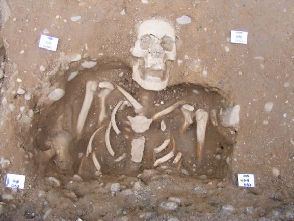
32
Archaeological Excavations at Bawtry Masonic Hall, South Yorkshire, July 2010: the cemetery of the medieval hospital of St Mary Magdalene
 Archaeological Excavations at Bawtry Masonic Hall, South Yorkshire, July 2010: the cemetery of the medieval hospital of St Mary Magdalene L. McIntyre and D.M. Hadley Department of Archaeology University
Test-Pit 3: 31 Park Street (SK )
") -Pit 3: 31 Park Street (SK 40732 03178) -Pit 3 was excavated in a flower bed in the rear garden of 31 Park Street, on the northern side of the street and west of an alleyway leading to St Peter s Church,
-Pit 3: 31 Park Street (SK 40732 03178) -Pit 3 was excavated in a flower bed in the rear garden of 31 Park Street, on the northern side of the street and west of an alleyway leading to St Peter s Church,
ST PATRICK S CHAPEL, ST DAVIDS PEMBROKESHIRE 2015
 ST PATRICK S CHAPEL, ST DAVIDS PEMBROKESHIRE 2015 REPORT FOR THE NINEVEH CHARITABLE TRUST THE UNIVERSITY OF SHEFFIELD AND DYFED ARCHAEOLOGICAL TRUST Introduction ST PATRICK S CHAPEL, ST DAVIDS, PEMBROKESHIRE,
1 The East Oxford Archaeology and History Project
 1 The East Oxford Archaeology and History Project EXOP TEST PIT 72 Location: Bartlemas Chapel, Cowley Date of excavation: 6-8 November 2013. Area of excavation: 0.8m x 1.2m, at the eastern end of the chapel.
3. The new face of Bronze Age pottery Jacinta Kiely and Bruce Sutton
 3. The new face of Bronze Age pottery Jacinta Kiely and Bruce Sutton Illus. 1 Location map of Early Bronze Age site at Mitchelstown, Co. Cork (based on the Ordnance Survey Ireland map) A previously unknown
Peace Hall, Sydney Town Hall Results of Archaeological Program (Interim Report)
") Results of Archaeological Program (Interim Report) Background The proposed excavation of a services basement in the western half of the Peace Hall led to the archaeological investigation of the space in
Results of Archaeological Program (Interim Report) Background The proposed excavation of a services basement in the western half of the Peace Hall led to the archaeological investigation of the space in
Greater London GREATER LONDON 3/606 (E ) TQ
 TQ") GREATER LONDON City of London 3/606 (E.01.6024) TQ 30358150 1 PLOUGH PLACE, CITY OF LONDON An Archaeological Watching Brief at 1 Plough Place, City of London, London EC4 Butler, J London : Pre-Construct
GREATER LONDON City of London 3/606 (E.01.6024) TQ 30358150 1 PLOUGH PLACE, CITY OF LONDON An Archaeological Watching Brief at 1 Plough Place, City of London, London EC4 Butler, J London : Pre-Construct
39, Walnut Tree Lane, Sudbury (SUY 073) Planning Application No. B/04/02019/FUL Archaeological Monitoring Report No. 2005/112 OASIS ID no.
 Planning Application No. B/04/02019/FUL Archaeological Monitoring Report No. 2005/112 OASIS ID no.") 39, Walnut Tree Lane, Sudbury (SUY 073) Planning Application No. B/04/02019/FUL Archaeological Monitoring Report No. 2005/112 OASIS ID no. 9273 Summary Sudbury, 39, Walnut Tree Lane, Sudbury (TL/869412;
39, Walnut Tree Lane, Sudbury (SUY 073) Planning Application No. B/04/02019/FUL Archaeological Monitoring Report No. 2005/112 OASIS ID no. 9273 Summary Sudbury, 39, Walnut Tree Lane, Sudbury (TL/869412;
Church of St Peter and St Paul, Great Missenden, Buckinghamshire
 Church of St Peter and St Paul, Great Missenden, Buckinghamshire An Archaeological Watching Brief for the Parish of Great Missenden by Andrew Taylor Thames Valley Archaeological Services Ltd Site Code
An archaeological evaluation at 16 Seaview Road, Brightlingsea, Essex February 2004
 An archaeological evaluation at 16 Seaview Road, Brightlingsea, Essex February 2004 report prepared by Kate Orr on behalf of Highfield Homes NGR: TM 086 174 (c) CAT project ref.: 04/2b ECC HAMP group site
An archaeological evaluation in the playground of Colchester Royal Grammar School, Lexden Road, Colchester, Essex
 An archaeological evaluation in the playground of Colchester Royal Grammar School, Lexden Road, Colchester, Essex February 2002 on behalf of Roff Marsh Partnership CAT project code: 02/2c Colchester Museum
THE PRE-CONQUEST COFFINS FROM SWINEGATE AND 18 BACK SWINEGATE
 THE PRE-CONQUEST COFFINS FROM 12 18 SWINEGATE AND 18 BACK SWINEGATE An Insight Report By J.M. McComish York Archaeological Trust for Excavation and Research (2015) Contents 1. INTRODUCTION... 3 2. THE
Evidence for the use of bronze mining tools in the Bronze Age copper mines on the Great Orme, Llandudno
 Evidence for the use of bronze mining tools in the Bronze Age copper mines on the Great Orme, Llandudno Background The possible use of bronze mining tools has been widely debated since the discovery of
Former Whitbread Training Centre Site, Abbey Street, Faversham, Kent Interim Archaeological Report Phase 1 November 2009
 Former Whitbread Training Centre Site, Abbey Street, Faversham, Kent Interim Archaeological Report Phase 1 November 2009 SWAT. Archaeology Swale and Thames Archaeological Survey Company School Farm Oast,
2 Saxon Way, Old Windsor, Berkshire
 2 Saxon Way, Old Windsor, Berkshire An Archaeological Watching Brief For Mrs J. McGillicuddy by Pamela Jenkins Thames Valley Archaeological Services Ltd Site Code SWO 05/67 August 2005 Summary Site name:
Monitoring Report No. 99
 Monitoring Report No. 99 Enniskillen Castle Co. Fermanagh AE/06/23 Cormac McSparron Site Specific Information Site Name: Townland: Enniskillen Castle Enniskillen SMR No: FER 211:039 Grid Ref: County: Excavation
Small Finds Assessment, Minchery Paddock, Littlemore, Oxford (MP12)
") Small s Assessment, Minchery Paddock, Littlemore, Oxford (MP12) Introduction A total of 51 objects recovered from excavations at Minchery Paddock, Littlemore, Oxford (MP12) were submitted for dating and
Small s Assessment, Minchery Paddock, Littlemore, Oxford (MP12) Introduction A total of 51 objects recovered from excavations at Minchery Paddock, Littlemore, Oxford (MP12) were submitted for dating and
An archaeological watching brief and recording at Brightlingsea Quarry, Moverons Lane, Brightlingsea, Essex October 2003
 An archaeological watching brief and recording at Brightlingsea Quarry, Moverons Lane, Brightlingsea, Essex commissioned by Mineral Services Ltd on behalf of Alresford Sand & Ballast Co Ltd report prepared
Human remains from Estark, Iran, 2017
 Bioarchaeology of the Near East, 11:84 89 (2017) Short fieldwork report Human remains from Estark, Iran, 2017 Arkadiusz Sołtysiak *1, Javad Hosseinzadeh 2, Mohsen Javeri 2, Agata Bebel 1 1 Department of
Control ID: Years of experience: Tools used to excavate the grave: Did the participant sieve the fill: Weather conditions: Time taken: Observations:
 Control ID: Control 001 Years of experience: No archaeological experience Tools used to excavate the grave: Trowel, hand shovel and shovel Did the participant sieve the fill: Yes Weather conditions: Flurries
ARCHAEOLOGICAL EVALUATION AT BRIGHTON POLYTECHNIC, NORTH FIELD SITE, VARLEY HALLS, COLDEAN LANE, BRIGHTON. by Ian Greig MA AIFA.
 ARCHAEOLOGICAL EVALUATION AT BRIGHTON POLYTECHNIC, NORTH FIELD SITE, VARLEY HALLS, COLDEAN LANE, BRIGHTON by Ian Greig MA AIFA May 1992 South Eastern Archaeological Services Field Archaeology Unit White
New Composting Centre, Ashgrove Farm, Ardley, Oxfordshire
 New Composting Centre, Ashgrove Farm, Ardley, Oxfordshire An Archaeological Watching Brief For Agrivert Limited by Andrew Weale Thames Valley Archaeological Services Ltd Site Code AFA 09/20 August 2009
Colchester Archaeological Trust Ltd. A Fieldwalking Survey at Birch, Colchester for ARC Southern Ltd
 Colchester Archaeological Trust Ltd A Fieldwalking Survey at Birch, Colchester for ARC Southern Ltd November 1997 CONTENTS page Summary... 1 Background... 1 Methods... 1 Retrieval Policy... 2 Conditions...
NOTE A THIRD CENTURY ROMAN BURIAL FROM MANOR FARM, HURSTBOURNE PRIORS. by. David Allen with contributions by Sue Anderson and Brenda Dickinson
 Proc. Hampsh. Field Club Archaeol. Soc. 47, 1991, 253-257 NOTE A THIRD CENTURY ROMAN BURIAL FROM MANOR FARM, HURSTBOURNE PRIORS Abstract by. David Allen with contributions by Sue Anderson and Brenda Dickinson
ARCHAEOLOGICAL MONITORING REPORT
 ARCHAEOLOGICAL MONITORING REPORT SCCAS REPORT No. 2009/324 Thorington Hall, Stoke by Nayland SBN 087 HER Information Date of Fieldwork: November 2009 - January 2010 Grid Reference: TM 0131 3546 Funding
FURTHER MIDDLE SAXON EVIDENCE AT COOK STREET, SOUTHAMPTON (SOU 567)
") Roc. Hampshire Field Club Archaeol. Soc 52,1997, 77-87 (Hampshire Studies 1997) FURTHER MIDDLE SAXON EVIDENCE AT COOK STREET, SOUTHAMPTON (SOU 567) By M F GARNER andj VINCENT with a contribution byjacqueline
Roc. Hampshire Field Club Archaeol. Soc 52,1997, 77-87 (Hampshire Studies 1997) FURTHER MIDDLE SAXON EVIDENCE AT COOK STREET, SOUTHAMPTON (SOU 567) By M F GARNER andj VINCENT with a contribution byjacqueline
An archaeological evaluation at the Lexden Wood Golf Club (Westhouse Farm), Lexden, Colchester, Essex
, Lexden, Colchester, Essex") An archaeological evaluation at the Lexden Wood Golf Club (Westhouse Farm), Lexden, Colchester, Essex January 2000 Archive report on behalf of Lexden Wood Golf Club Colchester Archaeological Trust 12 Lexden
An archaeological evaluation at the Lexden Wood Golf Club (Westhouse Farm), Lexden, Colchester, Essex January 2000 Archive report on behalf of Lexden Wood Golf Club Colchester Archaeological Trust 12 Lexden
An archaeological watching brief at St Leonard s church, Hythe Hill, Colchester, Essex
 An archaeological watching brief at St Leonard s church, Hythe Hill, Colchester, Essex report prepared by Adam Wightman on behalf of Dorvell Construction CAT project ref.: 10/5d Colchester and Ipswich
Fieldwalking at Cottam 1994 (COT94F)
") Fieldwalking at Cottam 1994 (COT94F) Tony Austin & Elizabeth Jelley (19 Jan 29) 1. Introduction During the winter of 1994 students from the Department of Archaeology at the University of York undertook
Fieldwalking at Cottam 1994 (COT94F) Tony Austin & Elizabeth Jelley (19 Jan 29) 1. Introduction During the winter of 1994 students from the Department of Archaeology at the University of York undertook
Chapter 2. Remains. Fig.17 Map of Krang Kor site
 Chapter 2. Remains Section 1. Overview of the Survey Area The survey began in January 2010 by exploring the site of the burial rootings based on information of the rooted burials that was brought to the
A COIN OF OFFA FOUND IN A VIKING-AGE BURIAL AT VOSS, NORWAY. Bergen Museum.
 A COIN OF OFFA FOUND IN A VIKING-AGE BURIAL AT VOSS, NORWAY. BY HAAKON SCHETELIG, Doct. Phil., Curator of the Bergen Museum. Communicated by G. A. AUDEN, M.A., M.D., F.S.A. URING my excavations at Voss
Chapel House Wood Landscape Project. Interim Report 2013
 Chapel House Wood Landscape Project Interim Report 2013 Chapel House Wood Landscape Project Interim Report 2013 The annual Dales Heritage Field School was held at Chapel House Wood again this year, and
Archaeological Watching Brief (Phase 2) at Court Lodge Farm, Aldington, near Ashford, Kent December 2011
 at Court Lodge Farm, Aldington, near Ashford, Kent December 2011") Archaeological Watching Brief (Phase 2) at Court Lodge Farm, Aldington, near Ashford, Kent December 2011 SWAT. Archaeology Swale and Thames Archaeological Survey Company School Farm Oast, Graveney Road
Archaeological Watching Brief (Phase 2) at Court Lodge Farm, Aldington, near Ashford, Kent December 2011 SWAT. Archaeology Swale and Thames Archaeological Survey Company School Farm Oast, Graveney Road
TIPPERARY HISTORICAL JOURNAL 1994
 TPPERARY HSTORCAL JOURNAL 1994 County Tipperary Historical Society www.tipperarylibraries.ie/ths society@tipperarylibraries. ie SSN 0791-0655 Excavations at Cormac's Chapel, Cashel, 1992 and 1993: a preliminary
Silwood Farm, Silwood Park, Cheapside Road, Ascot, Berkshire
 Silwood Farm, Silwood Park, Cheapside Road, Ascot, Berkshire An Archaeological Watching Brief For Imperial College London by Tim Dawson Thames Valley Archaeological Services Ltd Site Code SFA 09/10 April
Greater London Region GREATER LONDON 3/567 (E.01.K099) TQ BERMONDSEY STREET AND GIFCO BUILDING AND CAR PARK
 TQ BERMONDSEY STREET AND GIFCO BUILDING AND CAR PARK") GREATER LONDON 3/567 (E.01.K099) TQ 33307955 156-170 BERMONDSEY STREET AND GIFCO BUILDING AND CAR PARK Assessment of an Archaeological Excavation at 156-170 Bermondsey Street and GIFCO Building and Car
GREATER LONDON 3/567 (E.01.K099) TQ 33307955 156-170 BERMONDSEY STREET AND GIFCO BUILDING AND CAR PARK Assessment of an Archaeological Excavation at 156-170 Bermondsey Street and GIFCO Building and Car
Essex Historic Environment Record/ Essex Archaeology and History
 Essex Historic Environment Record/ Essex Archaeology and History CAT Report 578 Summary sheet Address: Kingswode Hoe School, Sussex Road, Colchester, Essex Parish: Colchester NGR: TL 9835 2528 Type of
An archaeological evaluation at the Blackwater Hotel, Church Road, West Mersea, Colchester, Essex March 2003
 An archaeological evaluation at the Blackwater Hotel, Church Road, West Mersea, Colchester, Essex report prepared by Laura Pooley on behalf of Dolphin Developments (U.K) Ltd NGR: TM 0082 1259 CAT project
EVALUATION REPORT No. 273
 EVALUATION REPORT No. 273 Freeduff Presbyterian Church, 3 Oldtown road, Freeduff, Cullyhanna, County Armagh Licence No.: AE/13/133E Sapphire Mussen Report Date: 20/09/2013 Contents List of Figures... 2
Monitoring Report No Sacred Heart Church Aghamore Boho Co. Fermanagh AE/10/116E. Brian Sloan L/2009/1262/F
 Monitoring Report No. 202 Sacred Heart Church Aghamore Boho Co. Fermanagh AE/10/116E Brian Sloan L/2009/1262/F Site Specific Information Site Address: Sacred Heart Church, Aghamore, Boho, Co. Fermanagh
S E R V I C E S. St John the Baptist Church, Penshurst, Kent. Archaeological Watching Brief. by Daniel Bray and James McNicoll-Norbury
 T H A M E S V A L L E Y ARCHAEOLOGICAL S E R V I C E S St John the Baptist Church, Penshurst, Kent Archaeological Watching Brief by Daniel Bray and James McNicoll-Norbury Site Code: JPK11/25 (TQ 5273 4385)
Preliminary Report on the Second Season of Excavations conducted on Mis Island (AKSC)
") Preliminary Report on the Second Season of Excavations conducted on Mis Island (AKSC) Andrew Ginns During the 2005-06 season of fieldwork carried out on Mis Island, 1 exhumations from three separate medieval
Preliminary Report on the Second Season of Excavations conducted on Mis Island (AKSC) Andrew Ginns During the 2005-06 season of fieldwork carried out on Mis Island, 1 exhumations from three separate medieval
Cambridge Archaeology Field Group. Fieldwalking on the Childerley Estate, Cambridgeshire. Autumn 2014 to Spring Third interim report
 Cambridge Archaeology Field Group Fieldwalking on the Childerley Estate, Cambridgeshire Autumn 2014 to Spring 2015 Third interim report Summary Field walking on the Childerley estate of Martin Jenkins
Amarna South Tombs Cemetery The 2011 Excavations at the Lower Site and Wadi Mouth Site Preliminary Archaeological Report
 Amarna South Tombs Cemetery The 2011 Excavations at the Lower Site and Wadi Mouth Site Preliminary Archaeological Report A. Stevens July 2012 1 The 2011 season of excavations at the South Tombs Cemetery
MARSTON MICHAEL FARLEY
 MARSTON MICHAEL FARLEY On 9 March agricultural contractors, laying field drains for Bucks County Council Land Agent's Department, cut through a limestone structure at SP 75852301 in an area otherwise consistently
Fort Arbeia and the Roman Empire in Britain 2012 FIELD REPORT
 Fort Arbeia and the Roman Empire in Britain 2012 FIELD REPORT Background Information Lead PI: Paul Bidwell Report completed by: Paul Bidwell Period Covered by this report: 17 June to 25 August 2012 Date
An archaeological evaluation by trial-trenching at Playgolf, Bakers Lane, Westhouse Farm, Colchester, Essex
 An archaeological evaluation by trial-trenching at Playgolf, Bakers Lane, Westhouse Farm, Colchester, Essex commissioned by Mr Stephen Belchem on behalf of ADP Ltd. report prepared by Chris Lister Planning
Oxfordshire. Wallingford. St Mary-le-More. Archaeological Watching Brief Report. Client: JBKS Architects and St Mary s Renewal Campaign.
 St Mary-le-More Wallingford Oxfordshire Archaeological Watching Brief Report February 2010 Client: JBKS Architects and St Mary s Renewal Campaign Issue No:1 OA Job No: 4432 NGR: SU 6071 8933 Archaeological
ARCHAEOLOGICAL S E R V I C E S. St Nicholas' Church, Barrack Hill, Nether Winchendon, Buckinghamshire. Archaeological Watching Brief.
 T H A M E S V A L L E Y ARCHAEOLOGICAL S E R V I C E S St Nicholas' Church, Barrack Hill, Nether Winchendon, Buckinghamshire Archaeological Watching Brief by Steven Crabb Site Code: STW17/229 (SP 7735
Novington, Plumpton East Sussex
 Novington, Plumpton East Sussex The Flint Over 1000 pieces of flintwork were recovered during the survey, and are summarised in Table 0. The flint is of the same types as found in the previous survey of
Centre for Archaeological Fieldwork,
 Centre for Archaeological Fieldwork, School of Geography, Archaeology and Palaeoecology, Queen s University Belfast Data Structure Report No. 70 (preliminary report) Archaeological Excavations at Carrickfergus
THE RAVENSTONE BEAKER
 DISCOVERY THE RAVENSTONE BEAKER K. J. FIELD The discovery of the Ravenstone Beaker (Plate Xa Fig. 1) was made by members of the Wolverton and District Archaeological Society engaged on a routine field
SALVAGE EXCAVATIONS AT OLD DOWN FARM, EAST MEON
 Proc. Hants. Field Club Archaeol. Soc. 36, 1980, 153-160. 153 SALVAGE EXCAVATIONS AT OLD DOWN FARM, EAST MEON By RICHARD WHINNEY AND GEORGE WALKER INTRODUCTION The site was discovered by chance in December
Tell Shiyukh Tahtani (North Syria)
") Tell Shiyukh Tahtani (North Syria) Report of the 2010 excavation season conducted by the University of Palermo Euphrates Expedition by Gioacchino Falsone and Paola Sconzo In the summer 2010 the University
Tell Shiyukh Tahtani (North Syria) Report of the 2010 excavation season conducted by the University of Palermo Euphrates Expedition by Gioacchino Falsone and Paola Sconzo In the summer 2010 the University
Phase 2 Urban consolidation AD
 Phase 2 Urban consolidation AD 1250-1350 The second recognised phase of activity at Rådhuspladsen corresponded approximately to the High medieval period (c. AD 1250 1350), and saw consolidation of the
Archaeological. Monitoring & Recording Report. Fulbourn Primary School, Cambridgeshire. Archaeological Monitoring & Recording Report.
 Fulbourn Primary School, Cambridgeshire Archaeological Monitoring & Recording Report October 2014 Client: Cambridgeshire County Council OA East Report No: 1689 OASIS No: oxfordar3-192890 NGR: TL 5190 5613
Moated Site at Manor Farm, Islip, Oxfordshire
 Moated Site at Manor Farm, Islip, Oxfordshire An Archaeological Excavation By Jo Pine Site Code MFI05 December 2007 Summary Site name: Moated Site at Manor Farm, Islip, Oxfordshire Grid reference: SP 5298
ARCHAEOLOGICAL EXCAVATION REPORT: THE PADDOCK, HIGH DIKE, NAVENBY, LINCOLNSHIRE
 ARCHAEOLOGICAL EXCAVATION REPORT: THE PADDOCK, HIGH DIKE, NAVENBY, LINCOLNSHIRE NGR: 499398, 357274 AAL Site Code: NAPA 13 OASIS Reference Number: allenarc1-205997 Report prepared for Navenby Archaeology
SERIATION: Ordering Archaeological Evidence by Stylistic Differences
 SERIATION: Ordering Archaeological Evidence by Stylistic Differences Seriation During the early stages of archaeological research in a given region, archaeologists often encounter objects or assemblages
7. Prehistoric features and an early medieval enclosure at Coonagh West, Co. Limerick Kate Taylor
 7. Prehistoric features and an early medieval enclosure at Coonagh West, Co. Limerick Kate Taylor Illus. 1 Location of the site in Coonagh West, Co. Limerick (based on the Ordnance Survey Ireland map)
Archaeological Material From Spa Ghyll Farm, Aldfield
 Archaeological Material From Spa Ghyll Farm, Aldfield Introduction Following discussions with Linda Smith the Rural Archaeologist for North Yorkshire County Council, Robert Morgan of 3D Archaeological
Archaeological evaluation at the Onley Arms, The Street, Stisted, Essex
 Archaeological evaluation at the Onley Arms, The Street, Stisted, Essex November 2014 report by Pip Parmenter and Adam Wightman with a contribution from Stephen Benfield and illustrations by Emma Holloway
An archaeological watching brief at Sheepen, Colchester, Essex November-December 2003
 An archaeological watching brief at Sheepen, Colchester, Essex November-December 2003 report prepared by Ben Holloway on behalf of Colchester Borough Council CAT project ref.: 03/11c Colchester Museums
Land North of Pesthouse Lane Barham Suffolk BRH 054
 Land North of Pesthouse Lane Barham Suffolk BRH 054 Archaeological Evaluation Report SCCAS Report No. 2012/142 Client: Barham Parish Council Author: Jezz Meredith September 2012 SCCAS Land North of Pesthouse
Suburban life in Roman Durnovaria
 Suburban life in Roman Durnovaria Additional specialist report Finds Ceramic building material By Kayt Brown Ceramic building material (CBM) Kayt Brown A total of 16420 fragments (926743g) of Roman ceramic
Changing People Changing Landscapes: excavations at The Carrick, Midross, Loch Lomond Gavin MacGregor, University of Glasgow
 Changing People Changing Landscapes: excavations at The Carrick, Midross, Loch Lomond Gavin MacGregor, University of Glasgow Located approximately 40 kilometres to the south-west of Oban, as the crow flies
Excavations at Shikarpur, Gujarat
 Excavations at Shikarpur, Gujarat 2008-2009 The Department of Archaeology and Ancient History, the M. S. University of Baroda continued excavations at Shikarpur in the second field season in 2008-09. In
The St. George s Caye Archaeology Project:
 The St. George s Caye Archaeology Project: Results of the 2015 Field Season Edited by James F. Garber Texas State University June, 2016 2 THE ST. GEORGE S CAYE ARCHAEOLOGY PROJECT: RESULTS OF THE 2015
Chapter 2: Archaeological Description
 Chapter 2: Archaeological Description Phase 1 Late Neolithic, c 3000-2400 BC (Figs 6-9) Evidence of Neolithic activity was confined to pits dug across the southern half of the site (Fig. 6). Eighteen pits
LAND WEST OF ELM GROVE, EBRINGTON, GLOUCESTERSHIRE. NGR: SP (centred) ARCHAEOLOGICAL EVALUATION
 ARCHAEOLOGICAL EVALUATION") LAND WEST OF ELM GROVE, EBRINGTON, GLOUCESTERSHIRE. NGR: SP 1892 4012 (centred) ARCHAEOLOGICAL EVALUATION Report No. 640 May 2009 1q LAND WEST OF ELM GROVE, EBRINGTON, GLOUCESTERSHIRE. NGR: SP 1892 4012
LAND WEST OF ELM GROVE, EBRINGTON, GLOUCESTERSHIRE. NGR: SP 1892 4012 (centred) ARCHAEOLOGICAL EVALUATION Report No. 640 May 2009 1q LAND WEST OF ELM GROVE, EBRINGTON, GLOUCESTERSHIRE. NGR: SP 1892 4012
Undley Hall, Lakenheath LKH 307
 ARCHAEOLOGICAL EVALUATION AND MONITORING REPORT SCCAS REPORT No. 2010/005 Undley Hall, Lakenheath LKH 307 E. Muldowney SCCAS January 2010 www.suffolkcc.gov.uk/e-and-t/archaeology Lucy Robinson, County
17 Phase 5. High and Late medieval features and activities AD
 17 Phase 5. High and Late medieval features and activities 1200 1550 AD 17.1 Results This time phase is based on all findings that can be placed in the High and Late medieval period 1200 1550 AD based
Cetamura Results
 Cetamura 2000 2006 Results A major project during the years 2000-2006 was the excavation to bedrock of two large and deep units located on an escarpment between Zone I and Zone II (fig. 1 and fig. 2);
1996 Figurine Report Naomi Hamilton
 1996 Figurine Report Naomi Hamilton THE FIGURINES AND OTHER SMALL FINDS Naomi Hamilton Some preliminary comments on the distribution of certain types of artefact, with particular attention to the trench
Rådhuspladsen, KBM 3827
 KØBENHAVNS MUSEUM / MUSEUM OF COPENHAGEN Rådhuspladsen, KBM 3827 Cultural Historical Report, Metro Cityring Excavation Ed Lyne and Hanna Dahlström Foreword As a result of the extensive archaeological
ROMAN, ANGLIAN AND ANGLO-SCANDINAVIAN ACTIVITY AND A MEDIEVAL CEMETERY ON LAND AT THE JUNCTION OF DIXON LANE AND GEORGE STREET, YORK
 YORK ARCHAEOLOGICAL TRUST ROMAN, ANGLIAN AND ANGLO-SCANDINAVIAN ACTIVITY AND A MEDIEVAL CEMETERY ON LAND AT THE JUNCTION OF DIXON LANE AND GEORGE STREET, YORK PRINCIPAL AUTHOR J.M. MCCOMISH WEB PUBLICATION
Museum of London Archaeological Archive: standards 2 Archive Components: Standards and Specifications 2.3 Finds
 Author Maloney, Cath. LAARC Version 3 Date 08/05/2013 Status Pre-publication Change History 2.9. Replacement of Registered Finds cards with image 2.3.4.3 2.8 Additions to Appendix: sample Finds Inventory
December 6, Paul Racher (P007) Archaeological Research Associates Ltd. 900 Guelph St. Kitchener ON N2H 5Z6
 Archaeological Research Associates Ltd. 900 Guelph St. Kitchener ON N2H 5Z6") Ministry of Tourism, Culture and Sport Culture Programs Unit Programs and Services Branch Culture Division 401 Bay Street, Suite 1700 Toronto ON M7A 0A7 Tel.: 416-314-2120 Ministère du Tourisme, de la
Ministry of Tourism, Culture and Sport Culture Programs Unit Programs and Services Branch Culture Division 401 Bay Street, Suite 1700 Toronto ON M7A 0A7 Tel.: 416-314-2120 Ministère du Tourisme, de la
Data Structure Report: Boho High Cross, Toneel North, Co. Fermanagh
 Data Structure Report: Boho High Cross, Toneel North, Co. Fermanagh Colm Donnelly, Philip Macdonald, Eileen Murphy and Nicholas Beer SMR No: Ferm 210:14 Grid Reference: H1167 4621 Excavation Licence: AE/02/49
Barnet Battlefield Survey
 In terim report on the progress of the Barnet Battlefield Survey December 2016 The Barnet Battlefield Survey is an archaeological investigation into the 1471 Battle of Barnet. It aims to define more accurately
Wantage County Primary School, Garston Lane, Wantage, Oxfordshire
 Wantage County Primary School, Garston Lane, Wantage, Oxfordshire An Archaeological Evaluation for Oxfordshire County Council by Erlend Hindmarch Thames Valley Archaeological Services Ltd Site Code GLW
Cambridge Archaeology Field Group. Fieldwalking on the Childerley Estate Cambridgeshire
 Cambridge Archaeology Field Group Fieldwalking on the Childerley Estate Cambridgeshire 2009 to 2014 Summary Fieldwalking on the Childerley estate of Martin Jenkins and Family has revealed, up to March
SUMMARY REPORT OF 2009 INVESTIGATIONS AT OLD TOWN, LANCASTER COUNTY, SOUTH CAROLINA
 SUMMARY REPORT OF 2009 INVESTIGATIONS AT OLD TOWN, LANCASTER COUNTY, SOUTH CAROLINA by R. P. Stephen Davis, Jr. Brett H. Riggs, and David J. Cranford 2012 Between April 29 and June 12, 2009, archaeological
The lithic assemblage from Kingsdale Head (KH09)
") 1 The lithic assemblage from Kingsdale Head (KH09) Hannah Russ Introduction During excavation the of potential Mesolithic features at Kingsdale Head in 2009 an assemblage of flint and chert artefacts were
1 The lithic assemblage from Kingsdale Head (KH09) Hannah Russ Introduction During excavation the of potential Mesolithic features at Kingsdale Head in 2009 an assemblage of flint and chert artefacts were
I MADE THE PROBLEM UP,
 This assignment will be due Thursday, Oct. 12 at 10:45 AM. It will be late and subject to the late penalties described in the syllabus after Friday, Oct. 13, at 10:45 AM. Complete submission of this assignment
Burrell Orchard 2014: Cleveland Archaeological Society Internship Amanda Ponomarenko The Ohio State University June - August 2014
 1 Burrell Orchard 2014: Cleveland Archaeological Society Internship Amanda Ponomarenko The Ohio State University June - August 2014 Selected for the 2014 Cleveland Archaeological Society Internship in
Grim s Ditch, Starveall Farm, Wootton, Woodstock, Oxfordshire
 Grim s Ditch, Starveall Farm, Wootton, Woodstock, Oxfordshire An Archaeological Recording Action For Empire Homes by Steve Ford Thames Valley Archaeological Services Ltd Site Code SFW06/118 November 2006
Medieval Burials and the Black Death
 Medieval Burials and the Black Death A Report on Badia Pozzeveri, Italy Bioarchaeology Field School Summer 2015 During the summer of 2015, I was given the opportunity to participate in the Ohio State University/Universitá
Archaeological sites and find spots in the parish of Burghclere - SMR no. OS Grid Ref. Site Name Classification Period
 Archaeological sites and find spots in the parish of Burghclere - SMR no. OS Grid Ref. Site Name Classification Period SU45NE 1A SU46880 59200 Ridgemoor Farm Inhumation Burial At Ridgemoor Farm, on the
A Fieldwalking Project At Sompting. West Sussex
 by John Funnell Introduction A Fieldwalking Project At Sompting. West Sussex During March -and April 1995 the Brighton and Hove Archaeological Society conducted fie1dwa1king in a field at Sompting West
Life and Death at Beth Shean
 Life and Death at Beth Shean by emerson avery Objects associated with daily life also found their way into the tombs, either as offerings to the deceased, implements for the funeral rites, or personal
Excavation Report. Medieval Occupation at Challis Green Barrington Cambridgeshire. Excavation Report. Client: Hills Partnership Limited.
 Medieval Occupation at Challis Green Barrington Cambridgeshire Excavation Report Excavation Report April 2012 Client: Hills Partnership Limited OA East Report No: 1269 OASIS No: oxfordar3-102493 NGR: TL
Lanton Lithic Assessment
 Lanton Lithic Assessment Dr Clive Waddington ARS Ltd The section headings in the following assessment report refer to those in the Management of Archaeological Projects (HBMC 1991), Appendix 4. 1. FACTUAL
ROMAN AND MEDIEVAL ACTIVITY IN THE UPPER WALBROOK VALLEY: EXCAVATIONS AT MOORGATE, CITY OF LONDON, EC2, 1997
 ROMAN AND MEDIEVAL ACTIVITY IN THE UPPER WALBROOK VALLEY: EXCAVATIONS AT 12 18 MOORGATE, CITY OF LONDON, EC2, 1997 Graham Bruce, Dominic Perring, Tim Stevens and Melissa Melikian SUMMARY In January and
An archaeological evaluation by trial-trenching at Scotts Farm, Lodge Lane, Purleigh, Essex October 2011
 An archaeological evaluation by trial-trenching at Scotts Farm, Lodge Lane, Purleigh, Essex October 2011 report prepared by Adam Wightman on behalf of Richard Emans CAT project ref.: 11/10a NGR: TL 582719
AN EARLY MEDIEVAL RUBBISH-PIT AT CATHERINGTON, HAMPSHIRE Bj>J. S. PILE and K. J. BARTON
 AN EARLY MEDIEVAL RUBBISH-PIT AT CATHERINGTON, HAMPSHIRE Bj>J. S. PILE and K. J. BARTON INTRODUCTION THE SITE (fig. 21) is situated in the village of Catherington, one mile north-west of Horndean and 200
Limited Archaeological Testing at the Sands House Annapolis, Maryland
 Limited Archaeological Testing at the Sands House Annapolis, Maryland Report Submitted to Four Rivers Heritage Area by John E. Kille, Ph.D., Shawn Sharpe, and Al Luckenbach, Ph.D February 10, 2012 In May-June
16 members of the Fieldwalking Group met York Community Archaeologist Jon Kenny at Lou Howard s farm, Rose Cottage Farm, at
 Terrington History Group Fieldwalking Group Field 1 Final report 21 October 2011 - fieldwalking 16 members of the Fieldwalking Group met York Community Archaeologist Jon Kenny at Lou Howard s farm, Rose
ARO1: Paying The Ferryman: An Archaeological Watching Brief At Lennel Church, Coldstream By Iraia Arabaolaza
 ARO1: Paying The Ferryman: An Archaeological Watching Brief At Lennel Church, Coldstream By Iraia Arabaolaza Archaeology Reports Online, 52 Elderpark Workspace, 100 Elderpark Street, Glasgow, G51 3TR 0141
S E R V I C E S. Glebe House, Reading Road, Wallingford, Oxfordshire. Archaeological Recording Action. by Andrew Mundin. Site Code: GHR15/256
 T H A M E S V A L L E Y ARCHAEOLOGICAL S E R V I C E S Glebe House, Reading Road, Wallingford, Oxfordshire Archaeological Recording Action by Andrew Mundin Site Code: GHR15/256 (SU 6068 8892) Glebe House,