BLEA TARN ROAD PIPELINE REPLACEMENT, LANCASTER, LANCASHIRE
|
|
|
- Angelica Horton
- 5 years ago
- Views:
Transcription
1 BLEA TARN ROAD PIPELINE REPLACEMENT, LANCASTER, LANCASHIRE Archaeological Watching Brief Report Oxford Archaeology North July 2006 RSK ENSR Environmental Ltd Issue No: /538 OA North Job No: L9683 NGR: SD to SD
2 Document Title: Document Type: BLEA TARN PIPELINE REPLACEMENT, LANCASTER, LANCASHIRE Archaeological Watching Brief Report Client Name: RSK ENSR Environmental Ltd Issue Number: /538 OA Job Number: L9683 National Grid Reference: SD to SD Prepared by: Andy Bates Position: Project Officer Date: July 2006 Checked by: Emily Mercer Signed. Position: Project Manager Date: July 2006 Approved by: Alan Lupton Signed. Position: Operations Manager Date: July 2006 Oxford Archaeology North Oxford Archaeological Unit Ltd (2006) Storey Institute Janus House Meeting House Lane Osney Mead Lancaster Oxford LA1 1TF OX2 0EA t: (0044) t: (0044) f: (0044) f: (0044) w: e: Oxford Archaeological Unit Limited is a Registered Charity No: Disclaimer: This document has been prepared for the titled project or named part thereof and should not be relied upon or used for any other project without an independent check being carried out as to its suitability and prior written authority of Oxford Archaeology being obtained. Oxford Archaeology accepts no responsibility or liability for the consequences of this document being used for a purpose other than the purposes for which it was commissioned. Any person/party using or relying on the document for such other purposes agrees, and will by such use or reliance be taken to confirm their agreement to indemnify Oxford Archaeology for all loss or damage resulting therefrom. Oxford Archaeology accepts no responsibility or liability for this document to any party other than the person/party by whom it was commissioned.
3 Blea Tarn Road Pipeline Replacement, Lancaster, Lancashire: Archaeological Watching Brief 1 CONTENTS SUMMARY...2 ACKNOWLEDGEMENTS INTRODUCTION Circumstances of Project Location, Geology and Topography Archaeological and Historical Background METHODOLOGY Fieldwork Archive FIELDWORK RESULTS Introduction Results Finds CONCLUSION Discussion Impact and Recommendations...10 BIBLIOGRAPHY...11 ILLUSTRATIONS...12 List of Figures...12 List of Plates...12 APPENDIX 1: CONTEXT LIST...13 APPENDIX 2: FINDS LIST...14
4 Blea Tarn Road Pipeline Replacement, Lancaster, Lancashire: Archaeological Watching Brief 2 SUMMARY National Grid PLC are to replace a 1.1km stretch of existing gas pipeline between Blea Tarn Road, Scotsforth, Lancaster to the north (NGR SD ) and Lancaster University to the south (NGR SD ). An initial feasibility study regarding the environmental constraints was carried out on behalf of the National Grid Plc by RSK ENSR Environmental Ltd (2006), within which no known archaeological resource was identified. However, the area of impact lies in close proximity to a number of late Iron Age/Romano-British sites. Therefore, there was the potential to disturb unknown archaeological remains. In consultation with Lancashire County Archaeological Services (LCAS) RSK ENSR Environmental Ltd recommended an archaeological watching brief during groundworks for the pipeline. This included topsoil stripping of the pipeline easement and the excavation of the pipe trench. Oxford Archaeology North were commissioned by RSK ENSR Environmental Ltd, on behalf of the National Grid Plc, to undertake the work, which was carried out between March 2006 to May The watching brief produced a variety of post-medieval domestic finds, of mainly nineteenth and twentieth century origin, that are likely to have derived from midden material. The base of a stone field boundary wall of possible early nineteenth century origin, underlying a current layered hedge. No deposits of archaeological significance were recorded within the development area, and there are, consequently, no recommendations for any further work.
5 Blea Tarn Road Pipeline Replacement, Lancaster, Lancashire: Archaeological Watching Brief 3 ACKNOWLEDGEMENTS Oxford Archaeology North would like to thank Kathryn Blyth of RSK ENSR Environmental Ltd for commissioning the work. Thanks are also due to Paul Cotteril and other construction staff on site of Willows Construction for their co-operation during the course of the fieldwork. The field work was carried out by Fraser Brown, Vix Hughes, Andy Bates, Steve Clarke and Sean McPhillips. The drawings were compiled by Marie Rowland, and the report written by Andy Bates. The finds were assessed by Chris Howard-Davis. Emily Mercer managed the project and edited the report.
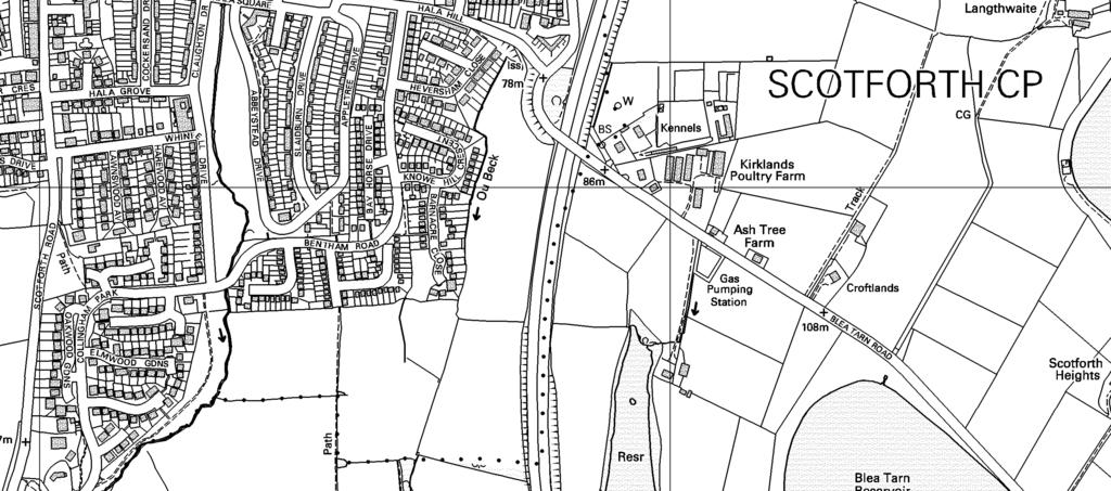
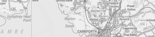
6 Blea Tarn Road Pipeline Replacement, Lancaster, Lancashire: Archaeological Watching Brief 4 1. INTRODUCTION 1.1 CIRCUMSTANCES OF PROJECT National Grid PLC proposed to replace a 1.1km stretch of existing gas pipeline between Blea Tarn Road, Scotsforth, Lancaster to the north (NGR SD ) and Lancaster University to the south (NGR SD ). An initial feasibility study regarding the environmental constraints was carried out on behalf of the National Grid Plc by RSK ENSR Environmental Ltd (2006). This entailed a desk-based assessment and walkover survey. The results showed that there was no known archaeological resource within the landtake for the scheme that would be affected. However, within a 500m radius of the site there are numerous late Iron Age and Roman-British sites. Therefore, there was a possibility that an unknown archaeological resource may be disturbed during groundworks Acting on behalf of their client, RSK ENSR Environmental Ltd (hereafter RSK ENSR) consulted Lancashire County Archaeological Services (LCAS) regarding mitigation of the proposed scheme and recommended an archaeological watching brief during associated groundworks for the pipeline. This included the initial topsoil stripping of the pipeline easement followed by the excavation of the pipe trench. Oxford Archaeology North (OA North) was commissioned by RSK ENSR, on behalf of the National Grid Plc, to undertake the work, which was carried out between March 2006 to May This report details the results of the watching brief, followed by a statement of the archaeological potential of the area and subsequent recommendations for further archaeological works where necessary. 1.2 LOCATION, GEOLOGY AND TOPOGRAPHY The pipeline easement is located parallel, and in fields adjacent to, the M6 motorway north of Lancaster University. The site is positioned to the east of the city of Lancaster, centred on NGR SD , in an area currently used as pasture (Fig 1) The gently undulating nature of the topography of the area is a direct result of glacial and post-glacial activity, which has produced drumlin-like formations. The underlying solid geology of the area consists of mudstones, probably of the Crossdale Mudstone Formation, of the Upper Carboniferous Millstone Grit series, dating to the Namurian geological era, 250 million years ago (Crofts 1992). Overlying the solid geology, the drift geology is, for the most part, glacial till (boulder clay) laid down approximately 10,000 years ago. The soils of the area belong to the Brickfield Association, which are cambic stagnogley soils (Jarvis et al 1984).
7 Blea Tarn Road Pipeline Replacement, Lancaster, Lancashire: Archaeological Watching Brief ARCHAEOLOGICAL AND HISTORICAL BACKGROUND Prehistoric Period: there is relatively little information about prehistoric activity in North Lancashire, which in part reflects the minimal amount of work carried out and partially the paucity of known remains from this period (Middleton et al 1995). Bronze Age cemeteries might be expected to be found in the area, since place names such as Barrow Greave and Burrow Heights are found nearby. However, the latter, located c 1.0km to the west of the development area, has produced only finds of Romano-British date (Neil 1995a) and has been found to be associated with cropmarks thought to be early field systems. More substantial evidence comes from a flint scatter revealed at Galgate Allotments in 1978, to the south of the development, which is thought to represent Bronze Age occupation (LSMR 2759) and a Bronze Age log boat found during construction of Blea Tarn Reservoir to the east of the study area (RSK ENSR 2006). Prehistoric activity has also been recorded in Lancaster, the earliest being a Neolithic Mortlake-type bowl at 65 Church Street (Jones and Shotter ). A Bronze Age palstave was found on Castle Hill and a group of Bronze Age urns were recovered from Lancaster Moor in the mid to late nineteenth century development of the area (Shotter and White 1990, 5). In the Iron Age, the area seems to have come under the aegis of the Brigantes (Cunliffe 1991). During development to extend Lancaster University and provide student accommodation at Barker House Farm, the site of a late Iron/Age/Romano-British farmstead was excavated (Bagwell forthcoming) Roman Period: in the vicinity of Galgate, south-west of the site, the various Roman roads from sites at Walton-le-Dale and the fort at Ribchester, identified by Margary (1973) as 70d and 704 respectively, are believed to have met and continued north towards the Roman fort and extramural settlement at Lancaster. The fort at Lancaster was founded on Castle Hill in the AD 70s and was followed by a sequence of forts on the site through to the fourth century (Shotter 1997). The road between Galgate and Lancaster has been recorded in two places. The first recorded site is at the former Royal Albert Hospital, where an earthwork appears to have survived, although excavations in the area produced ambiguous results (LUAU 2000; 2001). The second is at Highland Brow, west of the A6, where aerial photographs appear to show a linear mark consistent with a Roman road (Neil 1995b, 16). Situated on this road is an area known as Burrow Heights where several sites have produced Romano-British stone heads, milestones, and a third century AD coin of Claudius II (Shotter 1997) Of particular importance to the proposed route of the pipeline is the site of Barker House Farm within the grounds of Lancaster University, in close proximity to the southern end of the route. Recent excavations revealed a late Iron Age to early Romano-British roundhouse and double entranced circular enclosure within a larger agricultural enclosure, c 1.5km to the south-southwest of the current development area (Bagwell forthcoming). The intense level of Roman military occupation of the North West and the position of the study area in close proximity to the southern arterial route into Lancaster highlights the potential for occupation and settlement in the vicinity during the Roman period.
8 Blea Tarn Road Pipeline Replacement, Lancaster, Lancashire: Archaeological Watching Brief Medieval Period: the development area lies within the historical township of Scotforth. Before the Norman Conquest of 1066, Scotsforth manor was held by Cliber Machern and Gillemichael and was assessed for the purpose of the Domesday Survey in 1086 as two plough lands (Farrer and Brownbill 1914, 56-58). After the conquest the manor was given to Count Roger de Poitou, and eventually came into the hands of the Duchy of Lancaster (ibid). The land holdings within the township became complex and varied over time, land being sub-divided among a number of small residences and neighbouring lords, with both Cockersands Abbey and Lancaster Priory at one time holding lands within Scotsforth (ibid). Bailrigg, a hamlet within the township which lies immediately to the east of the development, was sometimes called a manor. Fields surrounding Bailrigg and Scotforth appear to be strip fields possibly dating to the medieval period, with evidence of ridge and furrow at the north end of the study area supporting this theory (RSK ENSR 2006, 21). The site of Cockshades Chapel, dating to the thirteenth century, is alleged to lie some distance to the south-south-east of the development area (Neil 1995b) Post-Medieval and Modern Periods: an Act of Parliament for the enclosure of Scotsforth was passed in 1809 (op cit). The majority of the field boundaries seen today probably relate to land organisation of this period. The two principal modern-day communication routes through the area are the A6 road and the M6 motorway. The A6 was originally part of the Garstang and Heron Syke Trust and was operated as a turnpike, dating from after 1786 (Yates 1786). The turnpike superseded a medieval road slightly to the east, the road to Scotland, shown on Yates map. This road gave Galgate its name, with Gal deriving from Galloway and Gate from gata meaning road, hence the road to Scotland.
9 Blea Tarn Road Pipeline Replacement, Lancaster, Lancashire: Archaeological Watching Brief 7 2. METHODOLOGY 2.1 FIELDWORK The programme of work undertaken complied with current legislation and accepted best practice, including the Code of Conduct and the relevant professional standards of the Institute of Field Archaeologists (IFA) The route of the pipeline passed through five fields that were numbered 1-5 from north to south (Fig 1). The topsoil strip was carried out using a 360 mechanical excavator, fitted with a 1.9m wide toothless bucket. Permanent observation of the work was undertaken by an OA North archaeologist for the easement of the topsoil strip. In agreement with LCAS, the excavation of the pipe trench was undertaken intermittently, with stretches of the previously excavated trench recorded during three site visits. However, due to problems encountered with the inwash of excavated material under wet weather conditions by the contractors, some stretches were immediately backfilled prior to archaeological recording. Any soil horizons exposed were examined, and all archaeological features, horizons and any artefacts found during the groundworks were accurately recorded Recording: the recording comprised a full description record and preliminary classification of all features and horizons revealed on OA North pro-forma sheets, as recommended by English Heritage Centre for Archaeology. A photographic record, using colour slide and monochrome formats, was compiled. 2.2 ARCHIVE A full professional archive has been compiled in accordance with current IFA and English Heritage guidelines (English Heritage 1991). The archive will be deposited in the Lancashire Records Office with a copy of the report to the Lancashire Historic Environment Record (HER).
10 Blea Tarn Road Pipeline Replacement, Lancaster, Lancashire: Archaeological Watching Brief 8 3. FIELDWORK RESULTS 3.1 INTRODUCTION An archaeological watching brief was conducted during removal of the topsoil for the pipeline easement and intermittent observations were undertaken during the excavation of the pipe trench, following verbal approval from LCAS. The easement was approximately 10m in width and was stripped of its topsoil to approximately 0.1m-0.2m. The pipe trench was excavated to an approximate overall depth of 1.2m and was between 0.5m-1.0m wide. The results of the watching brief are presented below by field number (Fig 2). Context descriptions are provided in Appendix RESULTS Field 1: the easement was stripped of its soil horizon under permanent presence, and benched for future machine access. The area was seen to be almost entirely within made ground associated with the construction of the M6 motorway located immediately to the east of the easement, and no evidence was observed of the underlying natural geology. No archaeologically significant deposits or finds were present Field 2: the topsoil comprised a very dark mid grey-brown sandy-clay, 0.2m thick, with 1% to 10% small sub-rounded stone inclusions. The underlying subsoil comprised a mid grey-brown fine sand-silty-clay with similar stone inclusions, 0.1m thick. The natural geology comprised a light grey-brown clay till, visible over less than 1% of the easement area. Pottery finds were recovered from the topsoil (see Section 3.3 below) At the boundary between Field 2 and 3, below the current hedge, the base of a dry stone wall, 1, was present. The tumble, 2, from this wall was revealed in Field 2 (Fig 2; Plate 1) Field 3: the topsoil and subsoil was the same as that observed in Field 2; a very dark grey-brown fine sandy-silty-clay topsoil, c 0.2m thick, and a mid grey-brown fine sand-silty-clay. The natural till deposit was observed over less than 1% of the area of the easement (Plate 2) but was seen within the excavated pipe trench. It comprised a medium sandy-clay with occasional subrounded stone of a maximum of 0.33m by 0.22m by 0.18m Finds of pottery and glass were recovered from the topsoil (see Section 3.3 below). No features of archaeological significance were recorded beyond the location of a nineteenth century field drain (Fig 2) approximately 0.3m below the interface between topsoil and subsoil Field 4: the topsoil was the same as that observed in Fields 2 and 3; a very dark grey-brown fine sandy-silty-clay topsoil, c 0.2m thick (Plate 3). This overlay the natural till deposit, which was an orange-brown medium sandy-
11 Blea Tarn Road Pipeline Replacement, Lancaster, Lancashire: Archaeological Watching Brief 9 clay banded with blue clay-silt. The till contained inclusions of sub-rounded boulders of various parent material and generally less than 0.3m in diameter Finds of pottery and glass were recovered from the topsoil (see Section 3.3 below), but no features of archaeological significance were recorded Field 5: the topsoil was a mid brown fine silty-clay with occasional mid-to large boulders. The natural till was observed in the excavated pipe trench as an orange-brown medium sandy-clay banded with blue clay-silt; the same as that observed in Field 4. Five nineteenth century ceramic field drains, c 0.15m in diameter, were observed approximately 0.3m below the base of the topsoil in varying alignments in Fields 4 and 5 (Fig 2). Their presence is evidence that this area was not disturbed during the construction of the motorway in the 1960s. 3.3 FINDS In total, 15 fragments were recovered during the watching brief, from Fields 2, 3, and 4. All of the finds were derived from topsoil, or were unstratified. Their distribution is shown below, in Table 1, and a detailed breakdown is provided in Appendix 2. Field No. Pottery Glass Tile Totals Totals Table 1: Distribution of finds across the site The majority of the material recovered was pottery with some glass. These fragments were in medium-sized fragments, unabraded and in generally good condition. None of the finds examined are likely to be earlier than the early nineteenth century, and the glass fragments are all from later twentieth century vessels. A single black-glazed tile from Field 4 is probably also of nineteenth century date. All the material would appear to have a domestic origin, and is likely to have derived from midden material distributed across the area. The finds add very little to the interpretation of the site and have no potential for any further analysis.
12 Blea Tarn Road Pipeline Replacement, Lancaster, Lancashire: Archaeological Watching Brief CONCLUSION 4.1 DISCUSSION The watching brief undertaken on both the topsoil strip of the easement and the excavation of the pipe trench revealed no significant archaeological features or deposits. Examination of the existing field boundary between Fields 2 and 3 showed that the current hedge was preceded by a dry stone wall, 1. This wall probably dates to the early nineteenth century organisation of land boundaries, following the 1809 Parliamentary Enclosure Act for the enclosure of the township of Scotsforth, and similar structures can be seen elsewhere in the area. In addition, nineteenth century field drains recorded in Fields 3-5 showed this area had not been disturbed during the construction of the M6 motorway in the 1960s. A collection of nineteenth century finds, including glass and pottery, was recovered from the topsoil. This most likely relates to the action of midden spreading during this time. 4.2 IMPACT AND RECOMMENDATIONS The watching brief showed a lack of any significant finds or features present. Therefore, there was no impact on an archaeological resource during the development. However, Fields 2-5 showed evidence of very little modern disturbance and, given the close proximity of later prehistoric and Romano- British remains, there is potential for such remains elsewhere across the site. Therefore, should any further groundworks be undertaken in the future it is recommended that an archaeological investigation is considered.
13 Blea Tarn Road Pipeline Replacement, Lancaster, Lancashire: Archaeological Watching Brief 11 BIBLIOGRAPHY Bagwell forthcoming, Romano-British Settlement at the South-West Campus, Lancaster University Crofts, RJ, 1992 Geology of the Galgate Area, 1: Sheet SD45 NE, British Geological Survey Technical Report WA/92/05, Keyworth Cunliffe, B, 1991 Iron Age Communities, 3rd edn, London English Heritage, 1991 Management of Archaeological Projects, 2nd edn, London Farrer, W, and Brownbill, J (eds), 1914 Victoria History of the County of Lancaster, 8, London Haselgrove, C, 1996 The Iron Age, in R Newman (ed), The Archaeology of Lancashire, Lancaster, Jarvis, RA, Bendelow, VC, Bradley, RI, Caroll, DM, Furness, RR, Kilgour, INL, and King, SJ, 1984 Soils and their uses in Northern England, Harpenden Jones, GDB, and Shotter, DCA, 1988, Roman Lancaster, Manchester LUAU, 2000 Former Royal Albert Hospital: Archaeological Evaluation, unpubl rep LUAU, 2001 Former Royal Albert Hospital: Archaeological Watching Brief, unpubl rep Margary, ID, 1973 Roman Roads in Britain, 3rd edn, London Middleton, R, Wells, C, and Huckerby, E, 1995 The Wetlands of North Lancashire, North West Wetlands Survey, 3, Lancaster Imprints, 4, Lancaster Neil, NRJ, 1995a Lancaster University South West Campus Extension: Phase 1 Barker House Farm, Green Lane, unpubl rep Neil, NRJ, 1995b Lancaster University South West Campus Extension: Phase 2 Tree Plantations and Link Road to A6, unpubl rep RSK Environmental Ltd, 2006 Blea Tarn Road Pipeline Replacement. Environmental Key Issues Report, unpubl rep Shotter, DCA, 1997 Romans and Britons in North-West England, 2nd edn, Lancaster Shotter, DCA, and White, A, 1990 The Roman Fort and Town of Lancaster, North West Studies 18, CNWRS, Lancaster Yates, W, 1786 The County Palatine of Lancaster, Surveyed by Will m Yates (repr reduced 1982, Manchester)
14 Blea Tarn Road Pipeline Replacement, Lancaster, Lancashire: Archaeological Watching Brief 12 ILLUSTRATIONS LIST OF FIGURES Figure 1: Location Map Figure 2: Plan showing field numbers and features revealed during the groundworks LIST OF PLATES Plate 1: Base of dry-stone wall, 1, in Fields 2 and 3 with tumble 2 to left looking south Plate 2: Excavated pipeline easement, Field 3 looking north Plate 3: Laying of gas pipe, Field 4 looking east
15 Blea Tarn Road Pipeline Replacement, Lancaster, Lancashire: Archaeological Watching Brief 13 APPENDIX 1: CONTEXT LIST Field No. Context Description Dry stone wall - comprised sub-rounded stone; a maximum of 0.38m by 0.25m by 0.20m, with no bonding material, but roughly coursed. 2 2 Tumble of wall 1 - comprised 80-90% sub rounded stone a maximum of 0.35m by 0.28m by 0.22m in a very dark grey single sandy silty clay, topsoil, matrix Subsoil around wall 1 - comprised a mid-grey brown fine sand silty clay with occasional small stone inclusions.
16 Blea Tarn Road Pipeline Replacement, Lancaster, Lancashire: Archaeological Watching Brief 14 APPENDIX 2: FINDS LIST OR = Object Record Number; Qty = quantity Field No. Context OR Material Category Qty Description Date 2 Topsoil 2 Ceramic Vessel 1 Body fragment thin fluted jug or teacup with sprigged decoration 2 Topsoil 2 Ceramic Vessel 1 Body fragment white earthenware 2 Topsoil 2 Ceramic Vessel 3 Body fragments blue and white underglaze transferprinted earthenware, probably a dish and a chamber pot. 2 Topsoil 2 Ceramic Vessel 1 Small body fragment. Redware with white internal slip glazed to yellow. 3 Topsoil 5 Ceramic Vessel 2 Joining body fragments dish with upright beaded rim. Black-glazed redware, but where thin the glaze is greenish with a white speckle. 3 Topsoil 5 Ceramic Vessel 1 Body fragment late Industrial Slipware 3 Topsoil 5 Ceramic Vessel 1 Body fragment blue and white underglaze transferprinted earthenware, probably a dish and a chamber pot. 3 Topsoil 6 Glass Vessel 1 Body fragment. Thick colourless bottle. 3 Topsoil 6 Glass Vessel 1 Body fragment. Colourless. Nineteenth century or later Nineteenth century or later Nineteenth century Nineteenth century? Nineteenth century or later Nineteenth century Nineteenth century or later Twentieth century Twentieth century? 4 Unstrat 1 Glass Vessel 1 Body fragment, colourless. Twentyfirst century 4 Unstrat 3 Ceramic Vessel 1 Rim fragment small plain white china vessel. 4 Topsoil 4 Ceramic Building material 1 Worn black-glazed floor tile, no surviving original edges. Nineteenth century or later Nineteenth century?
17
18


19 Plate 1: Base of dry stone wall, 1, in Fields 2 and 3 with tumble 2 to left looking south Plate 2: Excavated pipeline easement, Field 3 looking north

20 Plate 3: Laying of gas pipe, Field 4 looking east
An archaeological evaluation at 16 Seaview Road, Brightlingsea, Essex February 2004
 An archaeological evaluation at 16 Seaview Road, Brightlingsea, Essex February 2004 report prepared by Kate Orr on behalf of Highfield Homes NGR: TM 086 174 (c) CAT project ref.: 04/2b ECC HAMP group site
New Composting Centre, Ashgrove Farm, Ardley, Oxfordshire
 New Composting Centre, Ashgrove Farm, Ardley, Oxfordshire An Archaeological Watching Brief For Agrivert Limited by Andrew Weale Thames Valley Archaeological Services Ltd Site Code AFA 09/20 August 2009
An archaeological watching brief and recording at Brightlingsea Quarry, Moverons Lane, Brightlingsea, Essex October 2003
 An archaeological watching brief and recording at Brightlingsea Quarry, Moverons Lane, Brightlingsea, Essex commissioned by Mineral Services Ltd on behalf of Alresford Sand & Ballast Co Ltd report prepared
Archaeological. Monitoring & Recording Report. Fulbourn Primary School, Cambridgeshire. Archaeological Monitoring & Recording Report.
 Fulbourn Primary School, Cambridgeshire Archaeological Monitoring & Recording Report October 2014 Client: Cambridgeshire County Council OA East Report No: 1689 OASIS No: oxfordar3-192890 NGR: TL 5190 5613
ARCHAEOLOGICAL EVALUATION AT BRIGHTON POLYTECHNIC, NORTH FIELD SITE, VARLEY HALLS, COLDEAN LANE, BRIGHTON. by Ian Greig MA AIFA.
 ARCHAEOLOGICAL EVALUATION AT BRIGHTON POLYTECHNIC, NORTH FIELD SITE, VARLEY HALLS, COLDEAN LANE, BRIGHTON by Ian Greig MA AIFA May 1992 South Eastern Archaeological Services Field Archaeology Unit White
Church of St Peter and St Paul, Great Missenden, Buckinghamshire
 Church of St Peter and St Paul, Great Missenden, Buckinghamshire An Archaeological Watching Brief for the Parish of Great Missenden by Andrew Taylor Thames Valley Archaeological Services Ltd Site Code
2 Saxon Way, Old Windsor, Berkshire
 2 Saxon Way, Old Windsor, Berkshire An Archaeological Watching Brief For Mrs J. McGillicuddy by Pamela Jenkins Thames Valley Archaeological Services Ltd Site Code SWO 05/67 August 2005 Summary Site name:
An archaeological evaluation at the Lexden Wood Golf Club (Westhouse Farm), Lexden, Colchester, Essex
, Lexden, Colchester, Essex") An archaeological evaluation at the Lexden Wood Golf Club (Westhouse Farm), Lexden, Colchester, Essex January 2000 Archive report on behalf of Lexden Wood Golf Club Colchester Archaeological Trust 12 Lexden
An archaeological evaluation at the Lexden Wood Golf Club (Westhouse Farm), Lexden, Colchester, Essex January 2000 Archive report on behalf of Lexden Wood Golf Club Colchester Archaeological Trust 12 Lexden
An archaeological evaluation in the playground of Colchester Royal Grammar School, Lexden Road, Colchester, Essex
 An archaeological evaluation in the playground of Colchester Royal Grammar School, Lexden Road, Colchester, Essex February 2002 on behalf of Roff Marsh Partnership CAT project code: 02/2c Colchester Museum
Silwood Farm, Silwood Park, Cheapside Road, Ascot, Berkshire
 Silwood Farm, Silwood Park, Cheapside Road, Ascot, Berkshire An Archaeological Watching Brief For Imperial College London by Tim Dawson Thames Valley Archaeological Services Ltd Site Code SFA 09/10 April
Grim s Ditch, Starveall Farm, Wootton, Woodstock, Oxfordshire
 Grim s Ditch, Starveall Farm, Wootton, Woodstock, Oxfordshire An Archaeological Recording Action For Empire Homes by Steve Ford Thames Valley Archaeological Services Ltd Site Code SFW06/118 November 2006
Archaeological Watching Brief (Phase 2) at Court Lodge Farm, Aldington, near Ashford, Kent December 2011
 at Court Lodge Farm, Aldington, near Ashford, Kent December 2011") Archaeological Watching Brief (Phase 2) at Court Lodge Farm, Aldington, near Ashford, Kent December 2011 SWAT. Archaeology Swale and Thames Archaeological Survey Company School Farm Oast, Graveney Road
Archaeological Watching Brief (Phase 2) at Court Lodge Farm, Aldington, near Ashford, Kent December 2011 SWAT. Archaeology Swale and Thames Archaeological Survey Company School Farm Oast, Graveney Road
Archaeological evaluation at the Onley Arms, The Street, Stisted, Essex
 Archaeological evaluation at the Onley Arms, The Street, Stisted, Essex November 2014 report by Pip Parmenter and Adam Wightman with a contribution from Stephen Benfield and illustrations by Emma Holloway
An archaeological evaluation at the Blackwater Hotel, Church Road, West Mersea, Colchester, Essex March 2003
 An archaeological evaluation at the Blackwater Hotel, Church Road, West Mersea, Colchester, Essex report prepared by Laura Pooley on behalf of Dolphin Developments (U.K) Ltd NGR: TM 0082 1259 CAT project
Monitoring Report No. 99
 Monitoring Report No. 99 Enniskillen Castle Co. Fermanagh AE/06/23 Cormac McSparron Site Specific Information Site Name: Townland: Enniskillen Castle Enniskillen SMR No: FER 211:039 Grid Ref: County: Excavation
Test-Pit 3: 31 Park Street (SK )
") -Pit 3: 31 Park Street (SK 40732 03178) -Pit 3 was excavated in a flower bed in the rear garden of 31 Park Street, on the northern side of the street and west of an alleyway leading to St Peter s Church,
-Pit 3: 31 Park Street (SK 40732 03178) -Pit 3 was excavated in a flower bed in the rear garden of 31 Park Street, on the northern side of the street and west of an alleyway leading to St Peter s Church,
An archaeological evaluation by trial-trenching at Playgolf, Bakers Lane, Westhouse Farm, Colchester, Essex
 An archaeological evaluation by trial-trenching at Playgolf, Bakers Lane, Westhouse Farm, Colchester, Essex commissioned by Mr Stephen Belchem on behalf of ADP Ltd. report prepared by Chris Lister Planning
Cambridge Archaeology Field Group. Fieldwalking on the Childerley Estate Cambridgeshire
 Cambridge Archaeology Field Group Fieldwalking on the Childerley Estate Cambridgeshire 2009 to 2014 Summary Fieldwalking on the Childerley estate of Martin Jenkins and Family has revealed, up to March
3. The new face of Bronze Age pottery Jacinta Kiely and Bruce Sutton
 3. The new face of Bronze Age pottery Jacinta Kiely and Bruce Sutton Illus. 1 Location map of Early Bronze Age site at Mitchelstown, Co. Cork (based on the Ordnance Survey Ireland map) A previously unknown
Grange Farm, Widmer End, Hughenden, Buckinghamshire
 Grange Farm, Widmer End, Hughenden, Buckinghamshire An Archaeological Evaluation for British Flora by Andy Taylor Thames Valley Archaeological Services Ltd Site Code GFH 05/63 July 2005 Summary Site name:
Colchester Archaeological Trust Ltd. A Fieldwalking Survey at Birch, Colchester for ARC Southern Ltd
 Colchester Archaeological Trust Ltd A Fieldwalking Survey at Birch, Colchester for ARC Southern Ltd November 1997 CONTENTS page Summary... 1 Background... 1 Methods... 1 Retrieval Policy... 2 Conditions...
Fieldwalking at Cottam 1994 (COT94F)
") Fieldwalking at Cottam 1994 (COT94F) Tony Austin & Elizabeth Jelley (19 Jan 29) 1. Introduction During the winter of 1994 students from the Department of Archaeology at the University of York undertook
Fieldwalking at Cottam 1994 (COT94F) Tony Austin & Elizabeth Jelley (19 Jan 29) 1. Introduction During the winter of 1994 students from the Department of Archaeology at the University of York undertook
Oxfordshire. Wallingford. St Mary-le-More. Archaeological Watching Brief Report. Client: JBKS Architects and St Mary s Renewal Campaign.
 St Mary-le-More Wallingford Oxfordshire Archaeological Watching Brief Report February 2010 Client: JBKS Architects and St Mary s Renewal Campaign Issue No:1 OA Job No: 4432 NGR: SU 6071 8933 Archaeological
Archaeological trial-trenching evaluation at Chappel Farm, Little Totham, Essex. April 2013
 Archaeological trial-trenching evaluation at Chappel Farm, Little Totham, Essex April 2013 report prepared by Ben Holloway commissioned by Tim Harbord Associates on behalf of Mr Tom Howie Planning reference:
Cambridge Archaeology Field Group. Fieldwalking on the Childerley Estate, Cambridgeshire. Autumn 2014 to Spring Third interim report
 Cambridge Archaeology Field Group Fieldwalking on the Childerley Estate, Cambridgeshire Autumn 2014 to Spring 2015 Third interim report Summary Field walking on the Childerley estate of Martin Jenkins
E x cav atio n R e p o r t
 Medieval Trackway on land at Ivy Farm Royston, Hertfordshire Excavation Report E x cav atio n R e p o r t October 2011 Client: CgMs Consulting OA East Report No: 1305 OASIS No: oxfordar3-112012 NGR: TL
ARCHAEOLOGICAL MONITORING REPORT
 ARCHAEOLOGICAL MONITORING REPORT SCCAS REPORT No. 2009/324 Thorington Hall, Stoke by Nayland SBN 087 HER Information Date of Fieldwork: November 2009 - January 2010 Grid Reference: TM 0131 3546 Funding
Greater London GREATER LONDON 3/606 (E ) TQ
 TQ") GREATER LONDON City of London 3/606 (E.01.6024) TQ 30358150 1 PLOUGH PLACE, CITY OF LONDON An Archaeological Watching Brief at 1 Plough Place, City of London, London EC4 Butler, J London : Pre-Construct
GREATER LONDON City of London 3/606 (E.01.6024) TQ 30358150 1 PLOUGH PLACE, CITY OF LONDON An Archaeological Watching Brief at 1 Plough Place, City of London, London EC4 Butler, J London : Pre-Construct
Former Whitbread Training Centre Site, Abbey Street, Faversham, Kent Interim Archaeological Report Phase 1 November 2009
 Former Whitbread Training Centre Site, Abbey Street, Faversham, Kent Interim Archaeological Report Phase 1 November 2009 SWAT. Archaeology Swale and Thames Archaeological Survey Company School Farm Oast,
Excavation. Post-Medieval Ditches. Land off Norwich Common Road Wymondham Norfolk. Excavation. Client: November 2013
 Land off Norwich Common Road Wymondham Norfolk. Excavation November 2013 Client: OA East Report No: 1546 OASIS No: oxfordar3-163105 NGR: TG 12770 02684 Excavation Post-Medieval Ditches Post-Medieval Ditches
Essex Historic Environment Record/ Essex Archaeology and History
 Essex Historic Environment Record/ Essex Archaeology and History CAT Report 578 Summary sheet Address: Kingswode Hoe School, Sussex Road, Colchester, Essex Parish: Colchester NGR: TL 9835 2528 Type of
SALVAGE EXCAVATIONS AT OLD DOWN FARM, EAST MEON
 Proc. Hants. Field Club Archaeol. Soc. 36, 1980, 153-160. 153 SALVAGE EXCAVATIONS AT OLD DOWN FARM, EAST MEON By RICHARD WHINNEY AND GEORGE WALKER INTRODUCTION The site was discovered by chance in December
An archaeological watching brief on one section of an Anglian Water main Spring Lane, Lexden, Colchester
 An archaeological watching brief on one section of an Anglian Water main Spring Lane, Lexden, Colchester April-September 2001 on behalf of Breheny Contractors CAT project ref.: 01/4D Colchester Museum
39, Walnut Tree Lane, Sudbury (SUY 073) Planning Application No. B/04/02019/FUL Archaeological Monitoring Report No. 2005/112 OASIS ID no.
 Planning Application No. B/04/02019/FUL Archaeological Monitoring Report No. 2005/112 OASIS ID no.") 39, Walnut Tree Lane, Sudbury (SUY 073) Planning Application No. B/04/02019/FUL Archaeological Monitoring Report No. 2005/112 OASIS ID no. 9273 Summary Sudbury, 39, Walnut Tree Lane, Sudbury (TL/869412;
39, Walnut Tree Lane, Sudbury (SUY 073) Planning Application No. B/04/02019/FUL Archaeological Monitoring Report No. 2005/112 OASIS ID no. 9273 Summary Sudbury, 39, Walnut Tree Lane, Sudbury (TL/869412;
7. Prehistoric features and an early medieval enclosure at Coonagh West, Co. Limerick Kate Taylor
 7. Prehistoric features and an early medieval enclosure at Coonagh West, Co. Limerick Kate Taylor Illus. 1 Location of the site in Coonagh West, Co. Limerick (based on the Ordnance Survey Ireland map)
Moated Site at Manor Farm, Islip, Oxfordshire
 Moated Site at Manor Farm, Islip, Oxfordshire An Archaeological Excavation By Jo Pine Site Code MFI05 December 2007 Summary Site name: Moated Site at Manor Farm, Islip, Oxfordshire Grid reference: SP 5298
An archaeological watching brief at Sheepen, Colchester, Essex November-December 2003
 An archaeological watching brief at Sheepen, Colchester, Essex November-December 2003 report prepared by Ben Holloway on behalf of Colchester Borough Council CAT project ref.: 03/11c Colchester Museums
Erection of wind turbine, Mains of Loanhead, Old Rayne, AB52 6SX
 Erection of wind turbine, Mains of Loanhead, Old Rayne, AB52 6SX Ltd 23 November 2011 Erection of wind turbine, Mains of Loanhead, Old Rayne, AB52 6SX CONTENTS 1 INTRODUCTION 3 2 ARCHAEOLOGICAL BACKGROUND
Archaeological Evaluation at Alconbury Weald Enterprise Zone
 Archaeological Evaluation at Alconbury Weald Enterprise Zone Archaeological Evaluation Report June 2015 Client: CgMS OA East Report No: 1768 OASIS No: oxfordar3-212519 NGR: TL 1975 7684 Archaeological
Lanton Lithic Assessment
 Lanton Lithic Assessment Dr Clive Waddington ARS Ltd The section headings in the following assessment report refer to those in the Management of Archaeological Projects (HBMC 1991), Appendix 4. 1. FACTUAL
Folkestone Warren High Cliff Instrumentation Kent Archaeological Watching Brief Report. Client: Costain. March 2017
 Folkestone Warren High Cliff Instrumentation Kent Archaeological Watching Brief Report March 2017 Client: Costain Issue No: v1.0 OA Reference No: 6551 NGR: TR 2590 3850 Folkestone Warren High Cliff Instrumentation,
AN ARCHAEOLOGICAL INVESTIGATION AT HAZELRIGG, LANCASTER,
 AN ARCHAEOLOGICAL INVESTIGATION AT HAZELRIGG, LANCASTER, 2011 12 John Zant, Jeremy Bradley and Christine Howard-Davis Abstract An archaeological investigation undertaken by Oxford Archaeology North before
16 members of the Fieldwalking Group met York Community Archaeologist Jon Kenny at Lou Howard s farm, Rose Cottage Farm, at
 Terrington History Group Fieldwalking Group Field 1 Final report 21 October 2011 - fieldwalking 16 members of the Fieldwalking Group met York Community Archaeologist Jon Kenny at Lou Howard s farm, Rose
FURTHER MIDDLE SAXON EVIDENCE AT COOK STREET, SOUTHAMPTON (SOU 567)
") Roc. Hampshire Field Club Archaeol. Soc 52,1997, 77-87 (Hampshire Studies 1997) FURTHER MIDDLE SAXON EVIDENCE AT COOK STREET, SOUTHAMPTON (SOU 567) By M F GARNER andj VINCENT with a contribution byjacqueline
Roc. Hampshire Field Club Archaeol. Soc 52,1997, 77-87 (Hampshire Studies 1997) FURTHER MIDDLE SAXON EVIDENCE AT COOK STREET, SOUTHAMPTON (SOU 567) By M F GARNER andj VINCENT with a contribution byjacqueline
An archaeological evaluation by trial-trenching at Scotts Farm, Lodge Lane, Purleigh, Essex October 2011
 An archaeological evaluation by trial-trenching at Scotts Farm, Lodge Lane, Purleigh, Essex October 2011 report prepared by Adam Wightman on behalf of Richard Emans CAT project ref.: 11/10a NGR: TL 582719
Greater London Region GREATER LONDON 3/567 (E.01.K099) TQ BERMONDSEY STREET AND GIFCO BUILDING AND CAR PARK
 TQ BERMONDSEY STREET AND GIFCO BUILDING AND CAR PARK") GREATER LONDON 3/567 (E.01.K099) TQ 33307955 156-170 BERMONDSEY STREET AND GIFCO BUILDING AND CAR PARK Assessment of an Archaeological Excavation at 156-170 Bermondsey Street and GIFCO Building and Car
GREATER LONDON 3/567 (E.01.K099) TQ 33307955 156-170 BERMONDSEY STREET AND GIFCO BUILDING AND CAR PARK Assessment of an Archaeological Excavation at 156-170 Bermondsey Street and GIFCO Building and Car
A Fieldwalking Project At Sompting. West Sussex
 by John Funnell Introduction A Fieldwalking Project At Sompting. West Sussex During March -and April 1995 the Brighton and Hove Archaeological Society conducted fie1dwa1king in a field at Sompting West
ARCHAEOLOGICAL S E R V I C E S. St Nicholas' Church, Barrack Hill, Nether Winchendon, Buckinghamshire. Archaeological Watching Brief.
 T H A M E S V A L L E Y ARCHAEOLOGICAL S E R V I C E S St Nicholas' Church, Barrack Hill, Nether Winchendon, Buckinghamshire Archaeological Watching Brief by Steven Crabb Site Code: STW17/229 (SP 7735
Archaeological Evaluation Report
 16-18 Church Street Brill Buckinghamshire o a February 2008 Client: Stephen Moss Developments Issue N o : 1 OA Job N o : 3858 Planning Ref N o : 06/01304 NGR: SP 6553 1377 Client Name: Stephen Moss Developments
CUMBRIA 2/635 (C ) NY
 NY") CUMBRIA Allerdale 2/635 (C.16.6017) NY 11803070 BRIDGE STREET, COCKERMOUTH Report on an Archaeological Evaluation at Bridge Street, Cockermouth, Cumbria (Report No. 5/00) Grahame, R Carlisle : Carlisle
CUMBRIA Allerdale 2/635 (C.16.6017) NY 11803070 BRIDGE STREET, COCKERMOUTH Report on an Archaeological Evaluation at Bridge Street, Cockermouth, Cumbria (Report No. 5/00) Grahame, R Carlisle : Carlisle
AN EARLY MEDIEVAL RUBBISH-PIT AT CATHERINGTON, HAMPSHIRE Bj>J. S. PILE and K. J. BARTON
 AN EARLY MEDIEVAL RUBBISH-PIT AT CATHERINGTON, HAMPSHIRE Bj>J. S. PILE and K. J. BARTON INTRODUCTION THE SITE (fig. 21) is situated in the village of Catherington, one mile north-west of Horndean and 200
Archaeological sites and find spots in the parish of Burghclere - SMR no. OS Grid Ref. Site Name Classification Period
 Archaeological sites and find spots in the parish of Burghclere - SMR no. OS Grid Ref. Site Name Classification Period SU45NE 1A SU46880 59200 Ridgemoor Farm Inhumation Burial At Ridgemoor Farm, on the
STONES OF STENNESS HISTORIC ENVIRONMENT SCOTLAND STATEMENT OF SIGNIFICANCE
 Property in Care (PIC) ID: PIC321 Designations: Scheduled Monument (SM90285); Taken into State care: 1906 (Guardianship) Last reviewed: 2003 HISTORIC ENVIRONMENT SCOTLAND STATEMENT OF SIGNIFICANCE STONES
A visit to the Wor Barrow 21 st November 2015
 A visit to the Wor Barrow 21 st November 2015 Following our exploration of Winkelbury a few weeks previously, we fast forwarded 12 years in Pitt Rivers remarkable series of excavations and followed him
A Sense of Place Tor Enclosures
 A Sense of Place Tor Enclosures Tor enclosures were built around six thousand years ago (4000 BC) in the early part of the Neolithic period. They are large enclosures defined by stony banks sited on hilltops
Monitoring Report No Sacred Heart Church Aghamore Boho Co. Fermanagh AE/10/116E. Brian Sloan L/2009/1262/F
 Monitoring Report No. 202 Sacred Heart Church Aghamore Boho Co. Fermanagh AE/10/116E Brian Sloan L/2009/1262/F Site Specific Information Site Address: Sacred Heart Church, Aghamore, Boho, Co. Fermanagh
Moray Archaeology For All Project
 School children learning how to identify finds. (Above) A flint tool found at Clarkly Hill. Copyright: Leanne Demay Moray Archaeology For All Project ational Museums Scotland have been excavating in Moray
ARCHAEOLOGICAL EVALUATION REPORT. Home Farm, Woolverstone
 ARCHAEOLOGICAL EVALUATION REPORT Home Farm, Woolverstone WLV 047 A REPORT ON THE ARCHAEOLOGICAL EVALUATION, 2007 Kieron Heard Field Team Suffolk County Council Archaeological Service December 2007 Lucy
Fort Arbeia and the Roman Empire in Britain 2012 FIELD REPORT
 Fort Arbeia and the Roman Empire in Britain 2012 FIELD REPORT Background Information Lead PI: Paul Bidwell Report completed by: Paul Bidwell Period Covered by this report: 17 June to 25 August 2012 Date
Barnet Battlefield Survey
 In terim report on the progress of the Barnet Battlefield Survey December 2016 The Barnet Battlefield Survey is an archaeological investigation into the 1471 Battle of Barnet. It aims to define more accurately
THE UNFOLDING ARCHAEOLOGY OF CHELTENHAM
 THE UNFOLDING ARCHAEOLOGY OF CHELTENHAM The archaeology collection of Cheltenham Art Gallery & Museum contains a rich quantity of material relating to the prehistoric and Roman occupation of the North
YCCCART is very grateful to Richard Broomhead for permission to publish this report online.
 YCCCART 2017/Y2 Yatton & Congresbury Wildlife Action Group A Documentary & Archaeological Survey Of Two Moorland Sites In Yatton & Congresbury R.A.Broomhead BA Field Archaeologist RAB/15/9 YCCCART is very
December 6, Paul Racher (P007) Archaeological Research Associates Ltd. 900 Guelph St. Kitchener ON N2H 5Z6
 Archaeological Research Associates Ltd. 900 Guelph St. Kitchener ON N2H 5Z6") Ministry of Tourism, Culture and Sport Culture Programs Unit Programs and Services Branch Culture Division 401 Bay Street, Suite 1700 Toronto ON M7A 0A7 Tel.: 416-314-2120 Ministère du Tourisme, de la
Ministry of Tourism, Culture and Sport Culture Programs Unit Programs and Services Branch Culture Division 401 Bay Street, Suite 1700 Toronto ON M7A 0A7 Tel.: 416-314-2120 Ministère du Tourisme, de la
Undley Hall, Lakenheath LKH 307
 ARCHAEOLOGICAL EVALUATION AND MONITORING REPORT SCCAS REPORT No. 2010/005 Undley Hall, Lakenheath LKH 307 E. Muldowney SCCAS January 2010 www.suffolkcc.gov.uk/e-and-t/archaeology Lucy Robinson, County
Old Brewery Close and Walton Street, Aylesbury, Buckinghamshire
 Old Brewery Close and Walton Street, Aylesbury, Buckinghamshire An Archaeological Evaluation for Berkeley Homes (Oxford and Chiltern) Ltd by Sian Anthony Thames Valley Archaeological Services Ltd Site
Derwent Lodge Cottage and Sibby Brows Field, PAPCASTLE, CUMBRIA
 Derwent Lodge Cottage and Sibby Brows Field, PAPCASTLE, CUMBRIA Archaeological Report Oxford Archaeology North April 2008 Time Team Issue No: 2008-09/ 810 OA North Job Nos: L9508 NGR: NY 1093 3150 Derwent
Wantage County Primary School, Garston Lane, Wantage, Oxfordshire
 Wantage County Primary School, Garston Lane, Wantage, Oxfordshire An Archaeological Evaluation for Oxfordshire County Council by Erlend Hindmarch Thames Valley Archaeological Services Ltd Site Code GLW
THE PRE-CONQUEST COFFINS FROM SWINEGATE AND 18 BACK SWINEGATE
 THE PRE-CONQUEST COFFINS FROM 12 18 SWINEGATE AND 18 BACK SWINEGATE An Insight Report By J.M. McComish York Archaeological Trust for Excavation and Research (2015) Contents 1. INTRODUCTION... 3 2. THE
UNIVERSITY OF LANCASTER ARCHAEOLOGY CONFERENCE. 9 March 2002
 UNIVERSITY OF LANCASTER CENTRE FOR NORTH-WEST REGIONAL STUDIES ARCHAEOLOGY CONFERENCE 9 March 2002 A Chairman's Reflections - David Shotter Over the past thirty years, this Conference has become an established
This is a repository copy of Anglo-Saxon settlements and archaeological visibility in the Yorkshire Wolds.
 This is a repository copy of Anglo-Saxon settlements and archaeological visibility in the Yorkshire Wolds. White Rose Research Online URL for this paper: http://eprints.whiterose.ac.uk/1172/ Book Section:
Archaeological Material From Spa Ghyll Farm, Aldfield
 Archaeological Material From Spa Ghyll Farm, Aldfield Introduction Following discussions with Linda Smith the Rural Archaeologist for North Yorkshire County Council, Robert Morgan of 3D Archaeological
An archaeological watching brief at St Leonard s church, Hythe Hill, Colchester, Essex
 An archaeological watching brief at St Leonard s church, Hythe Hill, Colchester, Essex report prepared by Adam Wightman on behalf of Dorvell Construction CAT project ref.: 10/5d Colchester and Ipswich
Chapel House Wood Landscape Project. Interim Report 2013
 Chapel House Wood Landscape Project Interim Report 2013 Chapel House Wood Landscape Project Interim Report 2013 The annual Dales Heritage Field School was held at Chapel House Wood again this year, and
Land North of Pesthouse Lane Barham Suffolk BRH 054
 Land North of Pesthouse Lane Barham Suffolk BRH 054 Archaeological Evaluation Report SCCAS Report No. 2012/142 Client: Barham Parish Council Author: Jezz Meredith September 2012 SCCAS Land North of Pesthouse
39 & 41 MEDINA AVENUE, NEWPORT, ISLE OF WIGHT AN ARCHAEOLOGICAL EVALUATION REPORT. Planning Application Ref: Pre-Application
 39 & 41 MEDINA AVENUE, NEWPORT, ISLE OF WIGHT AN ARCHAEOLOGICAL EVALUATION REPORT National Grid Reference: SZ 5025 8861 Planning Application Ref: Pre-Application By: AOC ARCHAEOLOGY GROUP Commissioned
Suburban life in Roman Durnovaria
 Suburban life in Roman Durnovaria Additional specialist report Finds Ceramic building material By Kayt Brown Ceramic building material (CBM) Kayt Brown A total of 16420 fragments (926743g) of Roman ceramic
The Living and the Dead
 The Living and the Dead Round Barrows and cairns The transition from the late Neolithic to the early Bronze Age is traditionally associated with an influx of immigrants to the British Isles from continental
MARSTON MICHAEL FARLEY
 MARSTON MICHAEL FARLEY On 9 March agricultural contractors, laying field drains for Bucks County Council Land Agent's Department, cut through a limestone structure at SP 75852301 in an area otherwise consistently
Novington, Plumpton East Sussex
 Novington, Plumpton East Sussex The Flint Over 1000 pieces of flintwork were recovered during the survey, and are summarised in Table 0. The flint is of the same types as found in the previous survey of
St Germains, Tranent, East Lothian: the excavation of Early Bronze Age remains and Iron Age enclosed and unenclosed settlements
 Proc Soc Antiq Scot, 128 (1998), 203-254 St Germains, Tranent, East Lothian: the excavation of Early Bronze Age remains and Iron Age enclosed and unenclosed settlements Derek Alexander* & Trevor Watkinsf
An archaeological watching brief and evaluation at Great Notley business park, near Braintree, Essex June-September 2005
 An archaeological watching brief and evaluation at Great Notley business park, near Braintree, Essex report prepared by Kate Orr commissioned by Andrew Martin Associates Ltd on behalf of Countryside Properties
ROMAN OBJECTS FROM LANCASHIRE AND CUMBRIA: A ROUND-UP OF FINDS REPORTED VIA THE PORT ABLE ANTIQUITIES SCHEME IN 2006
 ROMAN OBJECTS FROM LANCASHIRE AND CUMBRIA: A ROUND-UP OF FINDS REPORTED VIA THE PORT ABLE ANTIQUITIES SCHEME IN 2006 Dot Bruns INTRODUCTION The Portable Antiquities Scheme is a voluntary scheme to record
An archaeological evaluation at Thistle Hall, Mope Lane, Wickham Bishops, Essex July 2009
 An archaeological evaluation at Thistle Hall, Mope Lane, Wickham Bishops, Essex July 2009 report prepared by Howard Brooks and Ben Holloway on behalf of Clarity Ecoworks Ltd CAT project ref.: 09/1f ECC
Excavation Report DRAFT. Early Medieval Ditch at Caxton Hall Cambridgeshire. Excavation Report. Client: Mr and Mrs Harrison.
 DRAFT Early Medieval Ditch at Caxton Hall Cambridgeshire Excavation Report Excavation Report December 2010 Client: Mr and Mrs Harrison OA East Report No: 1229 OASIS No: oxfordar3-87595 NGR: TL 3009 5830
Chapter 2. Remains. Fig.17 Map of Krang Kor site
 Chapter 2. Remains Section 1. Overview of the Survey Area The survey began in January 2010 by exploring the site of the burial rootings based on information of the rooted burials that was brought to the
Chapter 5 Block 7, Lot 1
 Chapter 5 Block 7, Lot 1 Christopher Fennell 1 and Christopher Valvano 2 One of our 2008 excavation teams focused on Block 7, Lot 1, based on multiple points of information, including previously known
SHORTER PAPERS A COLLECTION OF LITHIC ARTEFACTS FROM ASH PRIORS NEAR TAUNTON
 SHORTER PAPERS A COLLECTION OF LITHIC ARTEFACTS FROM ASH PRIORS NEAR TAUNTON The purpose of this note is to draw attention to a collection of flint and chert artefacts made by the late Laurence Walker
THE EXCAVATION OF A BURNT MOUND AT HARBRIDGE, HAMPSHIRE
 Proc Hampshire Field ClubArchaeolSoc5i, 1999,172-179 (Hampshire Studies 1999) THE EXCAVATION OF A BURNT MOUND AT HARBRIDGE, HAMPSHIRE by S J SHENNAN ABSTRACT A burnt mound of Late Brome Age date, as indicated
Archaeological trial-trenching evaluation at Dale Hall, Cox s Hill, Lawford, Essex
 Archaeological trial-trenching evaluation at Dale Hall, Cox s Hill, Lawford, Essex Fieldwork directed by Ben Holloway report prepared by Howard Brooks with a contribution by Stephen Benfield on behalf
Leeming to Barton Improvement
 Start of works exhibition March 2014 Welcome Introduction Following the public inquiry in November 2006, the Secretaries of State for Transport and Communities and Local Government announced the decision
Changing People Changing Landscapes: excavations at The Carrick, Midross, Loch Lomond Gavin MacGregor, University of Glasgow
 Changing People Changing Landscapes: excavations at The Carrick, Midross, Loch Lomond Gavin MacGregor, University of Glasgow Located approximately 40 kilometres to the south-west of Oban, as the crow flies
Whitton Church Lane (Recreation Ground) WHI 014
 WHI 014") ARCHAEOLOGICAL EVALUATION REPORT Whitton Church Lane (Recreation Ground) WHI 014 A REPORT ON THE ARCHAEOLOGICAL EVALUATION, 2008 (Planning app. no. 1362/05/FUL) Jezz Meredith Field Team Suffolk C.C. Archaeological
ARCHAEOLOGICAL EVALUATION REPORT Whitton Church Lane (Recreation Ground) WHI 014 A REPORT ON THE ARCHAEOLOGICAL EVALUATION, 2008 (Planning app. no. 1362/05/FUL) Jezz Meredith Field Team Suffolk C.C. Archaeological
THE RAVENSTONE BEAKER
 DISCOVERY THE RAVENSTONE BEAKER K. J. FIELD The discovery of the Ravenstone Beaker (Plate Xa Fig. 1) was made by members of the Wolverton and District Archaeological Society engaged on a routine field
BALNUARAN. of C LAVA. a prehistoric cemetery. A Visitors Guide to
 A Visitors Guide to BALNUARAN of C LAVA a prehistoric cemetery Milton of Clava Chapel (?) Cairn River Nairn Balnuaran of Clava is the site of an exceptionally wellpreserved group of prehistoric burial
1 The East Oxford Archaeology and History Project
 1 The East Oxford Archaeology and History Project EXOP TEST PIT 72 Location: Bartlemas Chapel, Cowley Date of excavation: 6-8 November 2013. Area of excavation: 0.8m x 1.2m, at the eastern end of the chapel.
NOTE A THIRD CENTURY ROMAN BURIAL FROM MANOR FARM, HURSTBOURNE PRIORS. by. David Allen with contributions by Sue Anderson and Brenda Dickinson
 Proc. Hampsh. Field Club Archaeol. Soc. 47, 1991, 253-257 NOTE A THIRD CENTURY ROMAN BURIAL FROM MANOR FARM, HURSTBOURNE PRIORS Abstract by. David Allen with contributions by Sue Anderson and Brenda Dickinson
A NEW ROMAN SITE IN CHESHAM
 A NEW ROMAN SITE IN CHESHAM KEITH BRANIGAN AND MICHAEL KIRTON THE site under discussion was first noted in 1958 and since that time several discoveries have been made. Its investigation has been pursued
Hayling School, Church Road, Hayling Island, Hampshire
 Hayling School, Church Road, Hayling Island, Hampshire An Archaeological Evaluation for George Wimpey Southern Ltd by Helen Moore Thames Valley Archaeological Services Ltd Site Code HSHI 03/46 July 2003
Bronze Age 2, BC
 Bronze Age 2,000-600 BC There may be continuity with the Neolithic period in the Early Bronze Age, with the harbour being used for seasonal grazing, and perhaps butchering and hide preparation. In the
SCOTLAND. Belfast IRISH SEA. Dublin THE REPUBLIC OF IRELAND ENGLAND ENGLISH CHANNEL. Before and After
 ALL ABOUT BRITAIN This book tells the story of the people who have lived in the British Isles, and is packed with fascinating facts and f un tales. The British Isles is a group of islands that consists