Forteviot, Perthshire: Excavations at the Entrance Avenue of the Neolithic Palisaded Enclosure Interim Report and Data Structure Report
|
|
|
- Suzan Harrington
- 5 years ago
- Views:
Transcription


1 Forteviot, Perthshire: Excavations at the Entrance Avenue of the Neolithic Palisaded Enclosure 2007 Interim Report and Data Structure Report by Gordon Noble and Kenneth Brophy
2 Table of Contents Summary 2 Introduction 2 Methodology and Objectives 2 Findings 3 Silted Palaeochannel 3 Putative Pre-Avenue Setting 3 The Avenue Posts 5 Internal Avenue Features 12 Features Outwith the Avenue 13 Tree throws 13 Pits outwith the avenue 14 Possible timber setting 16 Discussion 17 Human Remains 19 Internal Avenue Features 19 Tree Throws 20 Pit Features Around Avenue 20 Finds 21 Open Day 21 Conclusions 21 References 21 Appendices 22 i) Contexts 22 ii) Small Finds 27 iii) Drawings 28 iv) Samples 30 v) Photos
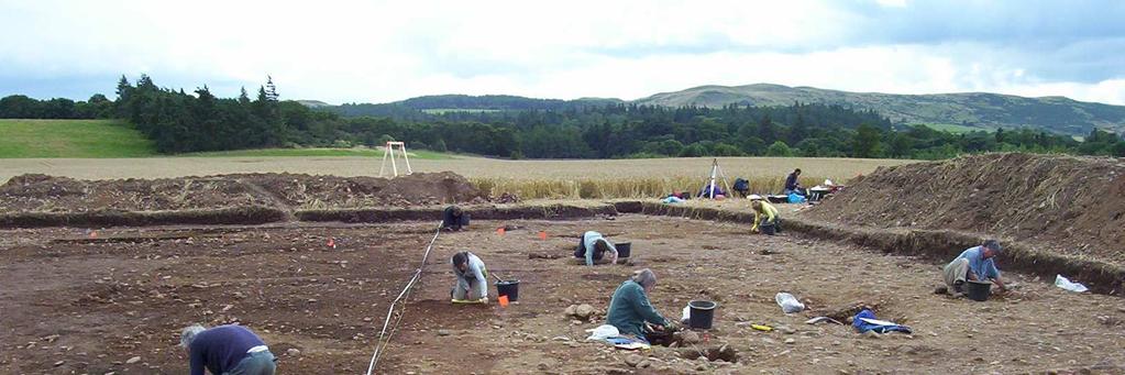
3 Summary Excavation was undertaken on the site of a possible Late Neolithic palisaded enclosure to the S of Forteviot village between 6 th and 26 th August 2007 as part of the Strathearn Environs and Royal Forteviot (SERF) Project and the University of Glasgow Field School. This site was initially identified as cropmarks through aerial photography. The 2007 season of excavation targeted the entrance avenue of the palisaded enclosure, revealing 16 of the 18 postholes of the avenue identified from cropmarks (Figure 1). Various other features, such as tree throws, pits and further postholes were found within and surrounding the avenue. Introduction One of the key aims of SERF is to sample the remarkable range of cropmark sites situated to the S of Forteviot village. The 2007 excavations focussed on the largest recorded coherent cropmark site, a pit-defined enclosure some 265m across, enclosing an area equivalent to 7 or 8 football pitches (NGR NO , NMRS NO01NE 28) (Figure 1). The boundary as seen from the air consists of a wobbly and intermittent series of over 130 pits defining an irregular circle; a double line of pits at the northern end appear to mark an entrance avenue into the enclosure. The W side of the enclosure is missing; this has either been lost to erosion, or the escarpment overlooking the Water of May to the W marked a natural boundary to the monument. This remarkable monument was first identified from the air by St Joseph in He identified at the same time a series of ancillary or perhaps related cropmark sites including possible henge monuments and timber circles (St Joseph 1976), many of which are situated within the pit-defined enclosure. St Joseph identified this enclosure as potentially Neolithic, and indeed it does seem superficially to belong to a class of monument that has become known as a palisaded enclosure, Later Neolithic timber monuments that have been recorded as cropmarks across northern and central Europe (Gibson 2002, Varndell & Topping 2002). Three similar sites have been recorded as cropmarks in Scotland and two have already been partially excavated: Meldon Bridge, Scottish Borders (Speak & Burgess 1999) and at Dunragit, Dumfries & Galloway (Thomas 2001, ). Both of these sites were indeed huge Later Neolithic enclosures defined by hundreds of large oak posts and we will draw comparisons from these excavations in this report. Interestingly, the fourth such enclosure, Leadketty, is situated some 3km W of Forteviot, N of the village of Dunning. The excavation took place between August 6 th and the 26 th, 2007 and was undertaken by a team of undergraduate and postgraduate students from the University of Glasgow and local volunteers. The excavation formed part of a wider season of fieldwork carried out for the SERF project (see and was part of the University of Glasgow Department of Archaeology Field School. Methodology and Objectives A rectangular trench approximately 37.5m x 25m was located over the cropmark of the avenue (Figure 1). From aerial photographs it appears that the avenue can be identified as consisting of eighteen pits, nine on each side. The trench encompassed almost the entire length of the avenue uncovering sixteen of the eighteen pits, with the two closest to the line of the palisaded enclosure remaining outside of the trench for future investigation. This trench was also positioned in order to investigate a significant area surrounding the avenue. Once the topsoil was stripped by a mechanical excavator, the trench was then cleaned using hoes and each context - 2 -
4 hand-excavated by trowel. Of the 16 avenue pits uncovered 75% (twelve) were excavated, three fully; the remainder were recorded by half-section. A sample of other potentially archaeologically significant features recorded within and surrounding the avenue was also excavated. The objectives of this season of excavation were to establish the: nature of the avenue; date and phasing (if any) of the avenue; nature of the subsoil; level of truncation of archaeological features; potential of archaeological features being present which were not visible as cropmarks. This report (which incorporates the Data Structure Report) will briefly summarise the findings of the excavation and our interim conclusions, detail the recorded archival material, and set out a strategy for post-excavation analysis. Throughout the report, the following conventions have been used to classify contexts: = Fill = Possible postpipe = Cut Fill numbers are listed in (parenthesis) and cut numbers in [square brackets]. Findings Silted Palaeochannel The western side of the avenue was identified at an early stage of the excavation. The dark silty loam fills of the avenue post-holes (see below) were easily visible as they cut the orange-brown gravel subsoil (003). The other side of the avenue was much harder to identify. It quickly became apparent that this was because an uneven and wide band of silty material (002) ran through the centre of the trench, running from NNW-SSE. The postholes of the eastern side of the avenue were located with some difficulty, not because the silt overlay them, but because the upper fills of these postholes were almost identical to the silt deposits they were dug into. The silt band is probably a Late Glacial palaeochannel (the site of a relic dried-up watercourse related to the retreat of the glaciers at the end of the last Ice Age). Careful cleaning and partial removal of the upper m of the silt helped reveal the eastern postholes of the avenue in plan. In retrospect the palaeochannel is visible in aerial photographs of the site. Putative Pre-avenue Setting Three of the large postholes on the W side of the avenue [031, 037, 041] were each paired with a much smaller and potentially earlier pit or posthole [033, 039, 109], in each case located immediately to the N (Table 1). The morphology and single fill of these features leave us unable to demonstrate whether they held a post or not; no post pipes were identified. At Meldon Bridge, and at least one of the palisade circuits at Dunragit palisaded enclosure, smaller features between main postholes were interpreted as being indicative of some form of fencing or screen, allowing the formation of a solid boundary (eg. Speak & Burgess 1999, 15ff). However, as these features were only found in association with one side of the avenue at Forteviot, and one of the features - 3 -

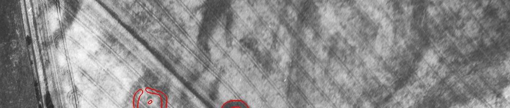
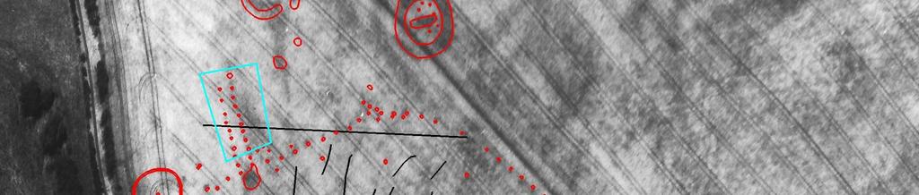
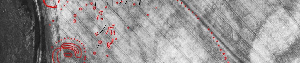
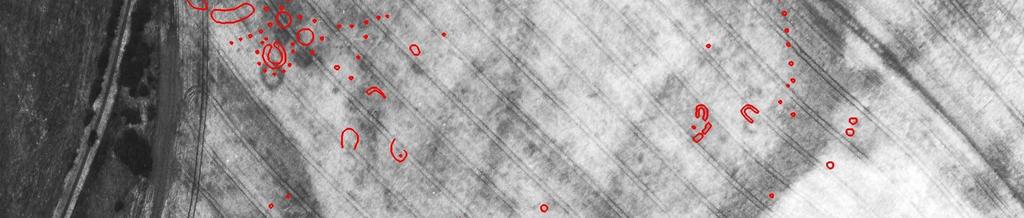
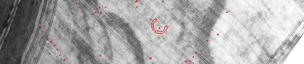
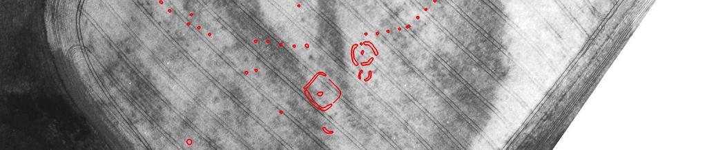
5 is beyond the end of the avenue, this interpretation seems unlikely. No evidence was found that these features necessarily supported a post, although we cannot rule this out, and must also bear in mind possible plough truncation of similar features. It is unclear if these features are even contemporary with the main avenue postholes; no stratigraphic relationship was established between them. Figure 1: A transcription and aerial photograph of the cropmarks at Forteviot. The red dots mark the former position of timber posts or pits. The largest group of red dots is the Neolithic timber enclosure, which measures around 265m N-S (N is at the top of the picture). Three of the circular enclosures are probably Neolithic henge monuments (ceremonial enclosures), while the fourth may be a later prehistoric palisaded enclosure. The largest henge has a timber circle surrounding it. The solid black lines are modern field drains. The more rectilinear/ square features towards the bottom of the picture may be Pictish burial monuments. The blue rectangle marks the area of the 2007 excavations. The aerial photograph is Crown Copyright RCAHMS, and the transcription was carried out by Kirsty Millican
6 If these features were not contemporary with the avenue, it may be that they formed a linear setting in their own right, either an alignment of pits, or perhaps a precursor of the avenue utilising much smaller posts. Apart from these three pits or postholes no other possible traces of an earlier avenue were identified; however, any such evidence may have been completely destroyed by the construction of the main avenue. Alternatively, these features may be associated with repairs to, or supporting elements of, the avenue, or could post-date the monument. Nonetheless, the coincidence of their alignment and recurring relationship with larger avenue posts suggests a close connection, one that may be better understood with the benefit of dating. Hopefully, therefore, analysis of environmental samples taken from these features will shed some more light on their role and relationship to the avenue. Table 1: Posthole / pit alignment descriptions Context No. Relation- Description Ship Dimensions/Location 034 Upper Fill Medium compaction mid orangey-brown Fill of small posthole [033]. silty-sand. 033 Cut Oval bowl shaped cut. 0.5 by 0.45, 0.23m depth. Small posthole adjacent to avenue post [031]. Drawing # Upper Fill Medium compact dark brown silty gravel Fill of possible posthole [039] with frequent small pebbles. 039 Cut Shallow U-shaped circular cut, round 0.55 x 0.50m, by 0.27m depth. Small bottomed, gradual slopes. posthole adjacent to avenue post [037]. Drawing # Upper Fill Loose light brown sandy silt, small pebbles Fill of posthole [109]. and larger angular cobbles (max 0.13m). 109 Cut Circular cut, u-shaped profile.?small posthole [109] fill next to avenue post [041]. Drawing # 51 The Avenue Posts The avenue posts were larger features, and in some cases difficult to excavate, either due to depth, or flooding. Prior to excavation, in plan, a typical avenue post was defined by a dark brown silty sub-circular patch with a lighter brown extended tail. These features proved to be where timber posts had once stood or the decay cones over the top of the post pipes; these were substantial features, with maximum diameter 2.2m and depth 1.25m. The lighter brown tail identified extending from many of the posts appears to have been ramps to aid erection of the timbers in the postholes. The recorded shallow depth and short length of these ramps suggests that these features have suffered from a degree of truncation. As indicated by the cropmark evidence, the avenue was defined by two parallel, but slightly irregular lines of postholes, running N-S. The avenue had a width of 4 6m
7 Figure 2: The post-excavation plan of the features recorded within the trench - 6 -
8 Table 2: Postholes on the eastern side of the avenue (N to S) Context Relation Description Dimensions/Location ship 085 F Dark brown silty loam with infrequent pebble inclusions. 1m diameter, 0.45m depth. avenue Post [076] possible post-pipe. 108 F Angular stone max 0.15m avenue Post [076]?collapsed packing. 077 F Below fill 108, increased gravel content. Mid brown silty gravel with frequent small pebbles, pea gravel. 0.6m max depth. avenue Post [076] slumped fill 180 F Light to mid brown silty gravel, wet and greasy, with frequent large rounded pebbles (max 0.1m). 1.1m diameter, max 0.5m depth. 076 C Large sub-circular cut. No ramp evident in plan. Steep sides, 1.8m E-W, 1.5m N-S, 1.15m depth (but not bottomed due to water table). Notes: No definite post-pipe Not fully excavated due to water table Uncertain ramp direction but probably to east/southeast Primary fill of avenue Post [076]. avenue Post. Fills 77, 85, 180. Drawing # F Loose dark brown silt, stones (max 0.1m). Width 0.66m, depth 0.53m. 147 F Loose mid brown sandy silt, small stones (0.03m max). 0.63m depth. 146 C Circular with steep sides, flat bottom. NW-SE 1.09m, 1.31m E-W, depth 0.63m. Post-pipe (170), c. 0.65m. Uncertain ramp location avenue post [146] Upper fill. avenue post [146] lower fill. avenue post, fills 147, 170. Drawing # C Irregular in plan. Orientation possible NW-SE. avenue post Unexcavated avenue post 166 F Very loose voided stony fill. Mid to dark brown silt, but in places little soil, mostly stone. Large?packing stones (collapsed)- up to 0.4m, angular and smaller rounded stones. Cremated bone throughout. Rapid backfill after removal of post- with cremated bone deposits. Avenue post [139]. 140 F Medium compaction mid brown silt- see drawing 83. Compact silty fill at side of posthole- original fill, prior to 166 removed post fill? avenue post [139] 139 C Round in plan (uncertain ramp location). U-shaped (though not bottomed due to water-logging). Steep sides. 1.45m E-W, at least 0.9m depth. Orientation probably NW-SE. Removed post- disturbed stony fill with voids (166). Cremated bone throughout fill (166) Uncertain ramp location but probably to south/southeast avenue post with removed post- disturbed packing. Fills 140, 166. Drawing # F Loose dark orangey-brown sandy silt, infrequent pebbles, charcoal flecks and larger stones (max 0.2m). 1.1m, 0.25m depth. Merges with silt 002 at top. Cremated bone. 163 F Moderately compact dark chocolate brown silt with charcoal flecks. 0.6m by 0.3m depth. 164 F Moderately compact orangy dark tan silt with charcoal flecks and large stones (max 0.2m) 0.5m by 0.55 depth. 150 F Loose dark black-brown silt with frequent substantial charcoal inclusions (up to 0.05m diameter). 0.35m by 0.35m depth. 125 C Sub circular, U-shaped profile, 75 sloping s ides. 1.35m E-W, 1.32m N-S, 0.62m depth. Uncertain post-pipe, possible 126, 163. Uncertain ramp location but probably to east/southeast Cremated bone, small fragments. Upper fill 126 avenue post [125] upper fill. Post-pipe. avenue post [125] mid fill. Post-pipe. avenue post [125] packing and fill. avenue post [125] lower fill. avenue post. Fills 126, 150, 163, 164. Drawing #
9 188 C Irregular in plan. avenue post Unexcavated avenue post 175 F Loose light yellow-grey silty sand, frequent stones (max 0.23m). 0.7m NE-SW, 0.91m NW-Se, depth 0.57m. 044 F Medium to loose compaction black to dark brown sandy silt. Cremated bone, occasional charcoal flecks, rounded stones (max 0.08m). 1.4m E-W, 1.5m N-S, 0.3m depth. 176 F Medium to loose compaction mottled black / dark grey sandy-silt, charcoal flecks, sub-angular stones (max 0.2m). 1.15m NE-SW, 1.14m NW-SE, 0.4m depth. 177 F Loose dark grey to brown-black wet clayey silt with coarse sand and gravel, frequent gravel inclusions, charcoal. 0.8m SW-NE, 0.84m NW-SE, 0.3m depth. 043 C Circular cut with ramp to NE, U-shaped, flat-bottom. Steep sloped. 2.1m NE-SW, 1.8m NW-SE, 1.04m depth. No postpipe evident Ramp to east- fill 175 Cremated bone- upper fill F Mid compaction dark greyish brown silt, charcoal angular stones (0.15 max). Fire-cracked stones. 145 F Friable dark brown medium sand, charcoal, infrequent rounded pebbles. 132 C Sub-circular feature with ramp. U-shaped profile. 2.23m by 1.43m by 0.7m depth. ENE-WSW. No post-pipe evident Ramp to east avenue Post [043] Ramp fill. Upper fill of avenue post [043]. avenue Post [043] Postpipe? Basal layer of avenue Post [043]. avenue post cut into silt. Fills 044, 175, 176, 177. Drawing # 82. avenue post [132] upper fill. avenue post [132]. Charcoal dump? avenue post, fills 133, 137, 157. Drawing # 74. From the northern end of the avenue (henceforth called the entrance ) the avenue on the E side began with posthole [076], the second largest posthole excavated. The final depth of this feature was unclear; excavation was abandoned due to continual flooding of the feature. This feature may have had a ramp on its E side, but there was no clear post-pipe. Proceeding south, feature [146] was originally interpreted as an avenue post due to its location; however, this was a much smaller feature than the others excavated in the avenue and may not form part of the main avenue structure. (In this sense, it may be better considered as an equivalent to the group of three features discussed above on the western side of the avenue.) The next certain posthole was [139], of similar dimensions to the very large posthole [076]. This feature had a disturbed, loose, stony fill (166), suggesting disturbance associated perhaps with post removal. Cremated human bone was found throughout (166). Feature [187] was not excavated and recorded only in plan, but its size and location means that it is almost certainly an avenue posthole. Feature [125] was the next posthole in the avenue and like [139] contained some cremated bone in its upper fill (126). However, there was strong evidence of a post having decayed in situ within this feature and charred timber was found in various contexts (163, 164, 150). Avenue post [043] had various fills, but no obvious post pipe, it also contained fragments of cremated bone in an upper fill (044). This feature had an obvious ramp on the E side, indicative of post erection in the feature. The final excavated posthole [132] also had a ramp to the E, but had a more homogenous fill (145). An anomalously large stone (157) was found within this posthole. This stone may have been deposited after the timber post was removed or had decayed, or it may have been an unusually large packing stone
10 Figure 3: The largest posthole excavated on the E side of the avenue, the entrance post Table 3: Postholes on the western side of the avenue (N to S) 042 F Loose mid brown silt, small pebbles and larger angular Avenue post [041], upper fill cobbles (max 0.2m). 0.85m by 0.5m depth. 169 F Loose dark brown silt, stones. 1.2m by 0.9m Avenue Post [041] Postpipe. 041 C Circular cut with shallow slope to north (ramp). 1.2m by 0.9m, max depth 0.83m. NE-SW. Avenue post, fills 042, 169. Drawing # 51. Possible post-pipe (042), up to 0.8m diameter. Packing material (169). Small posthole [109] adjacent. Not fully excavated due to watertable Cremated bone- upper fill. Very small quantity. Upper fill 042 Ramp to west 038 F Moderate compaction mid to dark brown loamy silt, with small pebbles (max 0.08m). 0.8m width, max depth 0.23m. 098 F Loose mid brown silt with pea gravel, angular stones (max 0.18m). 097 F Loose mid brown silty loam, small pebbles (max 0.1m). 0.6m wide. 100 F Loose mid brown silt, with numerous pebbles (max 0.09m). 099 F Loose light-brown orange silt, pea gravel, pebbles (max 0.04m). 037 C Posthole with ramp, roughly triangular in plan. Orientated N-S. 1.4m N-S, c. 0.7m E-W, 0.7m depth. Avenue post [037] upper fill. Avenue post [037] fill. Packing material Avenue post [037] fill Avenue post [037] fill Probable post-pipe (038, 097, 099), c.0.6m diameter. Collapsed packing (098) and (100). Ramp to?north 036 F Darker post-pipe/decay cone evident in plan with lighter brown ramp fill. 035 C Sub-rectangular in plan. Ramp to west. Avenue post Unexcavated avenue post Avenue post [037] fill, basal fill Avenue post, fills 038, 097, 098, 099, 100. Drawing # F Medium compaction mid orangey-brown silty sand. 0.9m Avenue post [031], upper fill. by 0.5m depth. 121 F Compact dark grey silt, small flecks of charcoal. Slumping layer at east side of avenue post [031]. 103 F Medium compaction dark black / grey silt, with large amount of charcoal > 60%. Major charcoal layer in avenue post [031] - 9 -
11 118 F Charcoal deposits with small percentage of dark silt. Charcoal deposits towards base of avenue post [031]. 159 F Loose grey / yellow silt, small stones / pebbles. Large percentage of charcoal. Major charcoal layer in base of avenue post [031]. 160 F Loose grey / yellow sandy-silt. Basal fill of avenue post [031] 112 (not in section) F Loose yellow-brown sandy silt, flecks of charcoal. Not in section drawings. Ramp fill of avenue post [031]. 031 C Circular cut with ramp. 2.16m by 1.1m by 0.83m depth. E- W. Avenue post, fills 032, 103, 112, 118, 121, 159, 160. Drawing # 50, 73. Post-pipe 032? c.0.7m? Abundant charred material found in 103, Basal fills of posthole- appears below post-pipe? Fire-cracked stones Ramp to west 021 F Loose light to mid brown silty clay with infrequent small pebble inclusions (20-30mm in diameter). 066 F Loose dark brown clay silt with infrequent rounded pebbles of size range 20-75mm. 0.7m diameter, 0.4m depth. 067 F Compact dark brown silty clay with frequent large round pebble inclusions. 1.5m diameter, 0.7m depth. 022 C Sub circular cut feature measuring 1.3m N-S by 1.25m, with maximum depth of 0.7m. The feature has steep sides and an irregular flat bottom, with a possible ramp on the NW side. Clear post-pipe 021, 066 with charcoal c.0.7m diameter. Uncertain ramp location but probably to west/north-west Upper fill of posthole on the W side of the avenue with cut [022] Post pipe of posthole on the W side of the avenue with cut [022] Primary fill / packing stones of posthole on the W side of the avenue with cut [022] Posthole on the W side of the avenue with fills (021), (066) and (067). Drawing # F Loose light brown silty sand, 10% small pebbles by 0.35m depth. 068 F Loose dark brown silty sand, occasional charcoal flecks, small rounded pebbles 0.02m. 0.55m x 0.5m depth. 069 F Medium compacted medium brown silty sand, with small pebble inclusions. 070 F Medium compaction mid brown silty sand, with small pebbles (max 0.1m). 013 C Circular posthole with ramp, 0.9m N-S, 2.04m E-W, 0.8m depth. Clear post-pipe (012, 068), c m diameter. Ramp to west avenue post [013] post-pipe fill. avenue post [013] post-pipe fill avenue post [013]. Ramp fill Primary fill of avenue post [013] avenue post, fills 070, 068, 012, 069. Drawing # F Loose dark brown silty soil with flecks of charcoal, large stones and pebbles x 0.50m, depth 0.15m. 055 F Loose dark brown clay/silt, with a few charcoal flecks. Approx 5% small stones. 0.7m by 0.6m, depth 0.3m. 056 F Compact very dark brown clay/silt, with frequent charcoal flecks and some stones. Clay inclusions pink in colour as found in base of feature- probably lumps of boulder clay. 060 F Looses orangey-brown sandy silt, with high gravel content. 1.3m x 0.5m by 0.65m depth. 057 F Medium compaction orangey-brown clay/silt. Scattered flecks of charcoal, small stones. 0.4 x 0.6m, 0.35m depth. 058 F Medium compaction dark brown clay/silt, very few charcoal specks, 5% small stones. 0.8 x 0.2m by 0.25m depth. 059 F Medium orangey-brown clay/silt, pea gravel inclusions. Patches of pink clay (see 056). 0.4m x 0.3m by 0.3m depth. 007 C Posthole (U-shaped) with ramp. Max 2.2m E-W, 1.1m depth Clear post-pipe (055, 056,?057), c.0.9m diameter. Ramp fill 060. Ramp to west avenue Post fill of cut [007] avenue Post [007] Postpipe fill. avenue Post [007] Postpipe fill. avenue Post [007] Ramp fill avenue Post [007] Postpipe fill. avenue Post [007] Fill around postpipe. avenue Post [007] Ramp fill avenue Post Cut with fills 006, 055, 056, 057, 058, 059, 060. Drawing # F Medium compacted dark brown sandy-silt, angular pebble inclusions ( m), avenue Post- postpipe fill
12 071 F Medium compaction blackish grey silt in two bands, 0.4m wide, bands each c.0.08m depth. 072 F Medium compaction mid brown sandy silt with some angular stone inclusions. 0.3m width, 0.4m depth. 075 F Loosely compacted dark brown silty-gravel, with varying angular stone inclusions. 0.9m length, 0.8m wide (approx), up to 0.2m depth. 073 F Medium compaction mid brown sandy-silt with some angular stone inclusions 074 F Loose mid brown gravel with some larger angular stone inclusions (max 0.2m). 1m x 0.05m depth. 024 C Posthole (U-shaped) with ramp. 2m E-W (posthole 1.2m) (ramp (0.8m). P--osthole max depth 0.5m, ramp 0.2m. Clear post-pipe (009, 071, 072), c.0.5m diameter. Ramp fill 075 Ramp to west avenue post [024] Post-pipe fill avenue post [024] Lower postpipe fill. avenue post [024]. Ramp fill avenue post [024] Lower postpipe fill. avenue post [024]. Base fill. avenue Posthole with fills 009, 071, 072, 073, 074, 075. Drawing # 20. The most northerly posthole on the W side of the avenue, [041], was a large feature and like the opposite entrance posthole [076], was not fully excavated due to flooding. Posthole [041] was the only one on the W side of the avenue to contain cremated bone in a fill (042). Adjacent to this entrance post was one of the small postholes or pits of the putative earlier setting [109]. Situated between avenue posthole [041] and, the next, [037] was a probable tree throw [110] and a second small posthole or pit feature of the putative earlier setting [039]. Avenue posthole [037] was relatively small and peculiarly shaped, with a short ramp on the N side. There is then a relatively large gap (4.2m) between this post-hole and the next avenue posthole to the S [035], which was unexcavated but had a ramp on the W side. Proceeding S, before the next avenue posthole [031] was the third small posthole or pit of the putative earlier setting [033] situated at its N edge. Avenue posthole [031] was one of the most complex postholes excavated (see Figure 4. It contained a variety of fills and a considerable amount of charred material including large lumps of charcoal. The remains of a ramp was situated on the W side of posthole [031]. To the S of this posthole four further ramped avenue postholes were excavated [022], [013], [007] and [024].. Posthole [007] was the largest of these. It contained a wider variety of fills than was typical of the other postholes (006, ) indicative of a complex sequence of backfilling, perhaps after post removal, and had a ramp on the W side (see Figure 5). Figure 4: Posthole 031, showing complex deposits within the cut for the post
13 Figure 5: Posthole 007, showing clearly the backfilled ramp and gradual silting up of the pit feature, presumably after the removal of the post? Internal Avenue Features Within the avenue, towards the N end, several small cut features were revealed during excavation. These included two stone-packed pits, [148] and [152], of uncertain function and date, and a small pit [028] with notable quantities of charcoal in its upper fill (027). Towards the S end of the avenue, a shallow slot was identified running from the eastern lip of avenue post [007] eastwards before turning SE towards avenue post [132] on the opposite side of the avenue. This feature was cut by an oval feature [005] with clear indication of burning in situ in its upper fills (004, 029). None of these features could be stratigraphically related to the avenue postholes. Table 4: Internal avenue features Large stone filled pit F Moderately compact dark orangey brown silt, with very stony fill (max 0.12m). 0.35m depth. 168 F Very compact light orange brown silt with stony fill (max 0.09m). 0.15m depth. 148 C Round, asymmetrical profile, gently sloping on west, sharper slope on east, flat bottom. 0.8m by 0.84m by 0.35m depth. Small stone filled pit F Very compact silty clay with c.50% pebbles. Dark brown. 0.48m N-S, 0.46m E-W, 0.14m depth. 152 C Round shallow bowl shaped cit with steep sides sloping sharply to round bottom. 0.48m N-S, 0.46m E-W, 0.14m depth. Small charcoal rich feature F Compact dark brown to black silty loam, with infrequent charcoal inclusions, few pebbles max 0.02m. 120 F Loose mid brown silty gravel, with infrequent pebble inclusions (max 0.025m). Below fill C Oblong cut feature 0.6m NNE-SSW by 0.25m. U-shaped profile, steep sides, rounded bottom. Max depth 0.17m. Upper fill of [148]. Lower fill of [148]. Possible posthole / stone filled pit within avenue. Fills 049, 168. Drawing # 80. Stony fill of small pit [152]. Small pit / truncated posthole within avenue. Fill 153. Drawing # 66. Upper fill of cut feature [028] in avenue area. Lower fill of indeterminate cut feature within avenue area [028] Indeterminate cut feature within avenue area, fill 027, 120. Drawing #
14 Slot F Compact greasy light brown/yellow silty sand with infrequent pebble inclusions. 138 C Linear cut feature with dog-leg in centre. 0.4m width, at least 1.4m long, max depth 0.12m. E-W on west side ESE-WNW on east side. Shallow sloping cut, irregular stony bottom. Edges indistinct in plan. Cut by [005] Fill of possible slot feature [138] in avenue Possible slot feature within avenue. Fill 167. Drawing # 59. Pyre feature F Loose dark brown silty loam with frequent charcoal flecks and lumps of carbonised wood 029 F Compact black silty organic layer with frequent charcoal inclusions from flecks to branches (max 0.23m length). Included burnt orange soil. Pyre? Burning in situ. Fill of [005] Pyre? Burning in situ. Fill of [005] 030 F Loose orange sandy gravel- lowest fill of feature Lower pyre? fill of [005] 005 C Cut for sub-rectangular feature with burning in situ 1.7m (N-S) by 0.8m by depth 0.42m. Pyre? Burning in situ. Fills 004, 029, 030. Drawing # 16. Burnt in situ- magnetometer readings very high. Also discoloured soil. Hazel branches. Features Outwith the Avenue A number of features outwith the avenue were quickly identified after initial cleaning of the trench; these could be divided into two categories. The first consists of large crescent-shaped silty loam and gravel filled features which are likely to have been tree throws and represent the former position of large trees. The second category is characterised by oval or sub circular small, ephemeral pits, usually occurring in groups of two or three (see below). Tree throws Tree throw [151] appears to be cut by the northeasternmost avenue posthole [076] and probably therefore relates to tree cover on the gravel terrace prior to the construction of the main avenue. Several other tree throws were found around the avenue [161/083, 107 and 088]. However, as these were difficult to identify in the gravel subsoil it is likely that more may have gone undetected particularly in the silt of the palaeochannel. An unexcavated feature [189] set within the palaeochannel may have been a tree throw. The chronology of these features is uncertain, although the positioning of a tree throw [107] at the entrance of the W side of the avenue, directly in line with the east side of the avenue may suggest they may be contemporary; however the positioning perhaps may be simply coincidence. Table 5: Tree throws & probable tree throws Tree throws: 142 F Medium compaction dark brown silt (lighter towards bottom of fill). Frequent charcoal inclusions, stones (max 0.2m). 1.8m x 1.1m x 0.45m depth. 162 F Medium compaction dark brown silt, sub-angular stones. 0.4 x 0.35 x 0.2m depth. 083 C Oval banana shape, U-shaped profile. Steeper west slope, shallower E slope. N-S. 2.8m x 0.9m x 0.42m depth. 161 C Oval / banana shaped feature, U-shaped profile. 0.4m x 0.35m by 0.2m depth. N-S. Feature given two cut numbers for opposing crescents. 104 F Loose dark brown silty sand, charcoal flecks, approx circular in plan within fill 113. Width max 0.4m, depth max 0.15m. 103 F Medium compaction dark black / grey silt, with large amount of charcoal > 60%. 105 F Loose mid brown silty gravel, frequent pebbles (max 0.1m). 2m E-W max, 0.4m depth. 107 C Oval in plan with two banana shaped bands of silt with lighter gravel centre. Uncertain profile. Max 2m E-W, uncertain depth, but at least 0.2m. In line with avenue posts west side Fill of tree throw banana [083] Fill of southern banana tree throw [161]. Northern and larger banana of tree throw. Fill 142. Southern = [161], 162 Southern banana of tree throw See also [083]. Fill 162. Drawing # 87. Tree throw [107] northern banana silt fill. Major charcoal layer in avenue post [031] Tree throw [107] fill. Tree throw, fills 104, 105, 106. Drawing #
15 089 F Moderate compaction medium brown silty clay with blackish brown patches, frequent small pebbles. 088 C Banana shaped, U-shaped profile with near vertical sides, irregular bottom. 1.4m length, 0.4m wide. NNE-SSW Tree throw [088] fill Tree throw, fill 089. Drawing # 88. Probable tree throws: 181 F Very compact dark blackish-brown silt, small stones (max 0.06m). 0.1m depth, 0.2m width. 154 F Mid compaction light browny-orange sandy silt, with angular stones (max 0.15m), 0.3m depth, 0.9m width. 151 C Curvilinear (banana) shaped feature 1.5m long, c.1m wide, 0.5m deep. Steep sides, flat base. NE orientation. Cut by avenue post [076] 141 F Compact in centre, looser at edges. Dark brown silt. 1.05m E-W, 0.6m wide, 0.25m depth. 110 C Curvilinear,?banana shaped, U-shaped profile with near vertical sides.?1.55m SE-NW (may extend further to west), 0.75m wide, 0.25m depth. Possibly cut by avenue post [037] and post [039] if full extent not excavated. 080 F Medium compaction dark brown silty clay, with angular stones up to 0.15m, pea gravel, small pebbles. 1.1m across (NE-SW), 0.28m max depth. 081 F Quite compact dark brown silty clay, with angular stones up to 0.15m, pea gravel, small pebbles. 1.8m NE-SW, 0.33m max depth. 079 C Irregular oval/circular in plan but irregular sides and slopes. Shallower on west side, sloping to deeper bottom on east side. 1.9m across, 0.33m depth at max. Upper fill of tree throw [151]. Fill of tree throw [151]. Possible tree throw cut by avenue Post [076]. Fills 154, 181. Drawing # 93. Tree throw banana [110] fill Possible tree throw- only banana visible, fill 141. Drawing # 69. Tree Throw [079] fill Tree Throw [079] fill Tree Throw, fills 080, 081. Drawing # F Loose greyish brown silty gravel, pebbles, larger stones (max 0.24m). 143 C Oval / banana shaped feature with a U-shaped profile. 1.4m by 0.3m by 0.3m depth. N-S. Possible tree throw [143] Possible tree throw, fill 144. Drawing # 58. Pits outwith the avenue Around the avenue numerous shallow oval pits were found (see tables below). These did not contain finds and at the time of the excavation little charred material could be identified. These features have, however, been rigorously sampled for environmental and dating evidence, which may shed more light on the function and date of these features. It was noted during excavation that these features tended to occur in pairs. Table 6: Features outwith the avenue Oval pit F Loose light brown clean silt with many small pebble angular inclusions of 15-20mm, and infrequently mm across. 019 C Irregular elongated oval-shaped cut feature measuring 1.41m N-S (long axis) by 0.4m, and maximum depth 0.21m. The feature has a rounded bottom with steep sides. cut by field drain 020 Oval pit F Loose dark brown silty clay with infrequent small angular stones at base of fill. 2nd fill. 0.2m diameter, 0.15m depth. 053 F Loose mid brown silty sand with infrequent small angular pebbles, infrequent larger cobbles. 0.63m width at max, 0.2m depth. 054 C Bowl shaped pit, max dimensions 1.35m N-S, 0.63m E- W, 0.2m depth. Fill of indeterminate feature with cut [019] within avenue area Indeterminate feature within the avenue area, single fill (018), cut by [020]. Drawing # 14. Oval pit fill- postpipe? Cut [054] Oval pit, fill of [054] Oval pit Cut. Fill 053. Drawing #
16 Oval pit F Medium compaction dark blackish brown silt, pebble inclusions. 0.44m, 0.19m depth. 084 F Medium compaction dark brown silty loam, pebbles, pea gravel. 1m x 0.74m, 0.25m depth. 078 C Oval cut (NW-SE) with irregular bottom, deeper at northwest end. 1m x 0.74m, 0.25m depth. Oval pit F Moderate compaction dark brown silty clay, pebbles clay. 1m x 0.6m by 0.3m depth. 086 C Oval/oblong (NW-SE) U-shaped cut with flat base. 0.6m x 1m by 0.3m depth. Oval pit F Loose medium orange-brown silt, with angular stones (max 0.15m). 156 F Friable mid to dark brown silt, charcoal inclusions. Small fill 0.035m diameter. 047 C Oval, U-shaped cut with sloping sides, rounded bottom. 1m x 0.7m, by 0.2m depth. WSW-ENE. Oval pit F Oval (NE-SW) shallow bowl-shaped cut. 1.15m x 0.9m by 0.2m. 062 C Medium compaction dark brown silt, with angular stones 0.24m max. 0.9m x 1.15m by 0.2m depth. Oval pit F Moderate compaction dark brown sandy silt, with pebbles, pea gravel. 1.42m x 0.82m x 0.22m depth. 090 C Irregular figure of eight shaped feature (N-S), flatbottomed, U-shaped. 1.42m x 0.82m, 0.22m depth. Oval pit F Moderate compaction brownish red silt with small pebbles (max 0.12m) and pea gravel. 0.9m by 0.5m by 0.28m depth. 101 C Oval, U-shaped profile, steep sides, 0.9m NW-SE, 0.5m wide, 0.28m depth. Oval pit / tree crescent F Moderate compaction light-brown sandy silt with small pebbles (max 0.08m). 131 F Moderate compaction medium orangey-brown silty gravel, with small rounded stone (max 0.03m) and pea gravel. Around base and sides of feature. 045 C Oval / banana shaped feature with U-shape profile. Sharp slope at sides, flat bottom, 1.3m NW-SE, 0.6m wide max, 0.25m depth. Oval pit F Medium compaction mid brown silty-sand with small stones. 173 C Oval, bowl-shaped with flat bottom. 0.9m by c.0.4m by 0.18m depth. NW-SE. Cut by furrow 171 Oval pit / tree crescent F Very compact light brown-yellow silty sand, very clean fill, very few stone inclusions. West side of feature, max 0.5m wide. 186 F Compact yellow to light brown silty gravel with frequent small peblle inclusions (max 0.03m). East side of feature. Max 0.3m width. 184 C Amorphous oval cut feature with bowl-shaped profile, deeper on west side. 0.8m E-W, 1.48m N-S, m depth. Small charcoal rich pit to east F Medium compaction dark brown silt, with large amounts of charcoal, small pebbles and pea gravel. Oval pit [078] upper fill Oval pit [078] lower fill Oval Pit, fills 082, 084. Drawing # 33. Oval pit [086] single fill Oval pit, fill 087. Drawing # 36. Truncated pit [047] in line with E side of avenue. Truncated pit [047] in line with E side of avenue. Truncated pit in line with E side of avenue. Fill 048, 156. Drawing # 38. Oval pit, fill 062 Oval pit fill. Cut [063]. Drawing # 37. Part of oval pit group? [090] Part of oval pit group? Fill 091. Drawing # 40. Oval pit [101] Oval pit, fill 102. Drawing # 41. Oval Pit / Tree Throw banana [045] Upper fill Basal fill of oval pit / tree throw banana Oval Pit / Tree Throw banana, fills 046, 131. Drawing # 44. Oval pit [173] single fill. Oval pit, fill 174. Drawing # 86. Oval pit / tree throw [184] fill. Primary fill of Oval pit / tree throw [184]. Oval pit / tree throw. Fills 185, 186. Drawing # 104. Heavily truncated small pit with burnt material
17 116 C Sub oval shallow bowl, gentle slopes, 0.5 n-s by 0.3m, 0.05m depth. Small pit F Compact dark brown silt / silt loam with 30% rounded pebble inclusions < 60mm. 011 C Circular cut feature measuring 0.26m in diameter with maximum depth 0.16m. Irregular stony base with shallow sides. Heavily truncated small pit with burnt material, fill 117. Drawing # 48. Single fill of a shallow cut feature [cut 011] outwith avenue area Small cut feature outwith the avenue area with a single fill (008). Drawing # 13. Circular pit F Compact dark brown silt, stones. Pit [127]. 183 F Loose dark brown to light brown gravel with frequent pebbles (max 0.05m). Max depth 0.18m Primary fill of cut feature [127]. 127 C Circular bowl shaped cut with steep sides. 0.75m by 0.7m by 0.28m depth. NE-SW. Pit in trench extension. Fills 128, 183. Drawing # 85. Large pit 093 F Moderate dark brown silt with small pebbles. 1.45m N-S, 0.32m depth 092 C?Circular in plan, bowl shaped profile, steep sides and irregular bottom. 1.45m N-S, 0.32m depth. in eastern baulk 092 Pit in E baulk [092]. Pit in E baulk, fill 093. Drawing # 56. Possible timber setting In the NE corner of the trench, a large posthole [023] was found with two attendant smaller pits or remnants of postholes or even stakeholes [136] and [134]. This is a possible timber setting erected away from the main enclosure. No artefacts were found in association with these features; environmental sampling may tell us more. Table 7: Possible timber setting 014 F Compact dark grey-brown silty loam with frequent small pebbles, occasional flecks of charcoal near centre of feature. Post-pipe posthole away from avenue. Fill of [024] 050 F Mid brown silty gravel. Charcoal flecks. 0.25m max. Postpipe fill of post [023] away from enclosure 049 F Loose brown silty gravel with large round pebbles at edge of fill width max. Postpipe fill of post [023] away from enclosure 051 F Loose light brown silty gravel. Postpipe fill of post [023] away from enclosure 052 F Packing stones, max 0.2m between edges of cut and postpipe Postpipe fill of post [023] away from enclosure 064 F Dark blackish brown silty clay sand with max thickness 0.03m Turf? in posthole away from avenue, [023] 023 C Circular cut feature diameter 0.8m with max depth 0.62m. U shaped. Posthole to east of avenue. Fills- 014, 049, 050, 051, 052, 064. Drawing # 15. Posthole found in Sector I away from avenue. Of different character and form to avenue posts. Smaller, no ramp. Adjacent features: 2 small pits 135 F Moderate compaction mid brown silty gravel. 0.27m E-W, 0.22 N-S, 0.18m depth 134 C Oval, U-shaped profile sloping sides with irregular bottom. 0.27m E-W, 0.22 N-S, 0.18m depth. 137 F Moderate compaction mid brown silty gravel, pebbles (max 0.15m). 0.39m x 0.31m by 0.18m depth. 136 C Su-circular bowl shaped with flat bottom. 0.39m x 0.31m by 0.18m depth. E-W. Truncacted pit [134], fill Truncacted pit, fill 135. Drawing # 55. Truncated pit [136], fill Truncated pit, fill 137. Drawing #
18 Discussion Although this report was written in advance of much of the post-excavation work, we can make some provisional interpretations and observations. Avenue construction and the timber posts The excavated avenue postholes suggest a monumental entrance passage to the palisaded enclosure. At this stage, we can make some general observations about the nature and form of the avenue. Firstly, how large were the timber posts used? Various calculations have been made on posthole depths in relation to the possible heights of timbers held within the postholes (e.g. Mercer 1981, 149ff). Regardless of the form of calculation, this is usually thought to be on a scale of 1:3 or 1:3.5 (see Figure 6). The deepest postholes at Forteviot, [076] and [007], at just over a metre depth, could theoretically have supported timbers of 4-5m in length. However millennia of tree clearance, agriculture and other erosion would likely have substantially denuded the ground level and we estimate that in prehistory as much as 1m of soil may have once existed above the present level of the gravel surface (Campbell 2008; Speak & Burgess 1999), leaving open the possibility of tree trunks of 6m length or more above ground. Furthermore, a tree has around two-thirds of its weight concentrated towards its base, and so even this figure may be a conservative estimate for the larger postholes. Not all of the excavated avenue posts were on this scale. Some, such as [024], were only around 0.5m deep, which means, using the calculation outlined above; a timber set within this posthole may have stood only 2-2.5m above the ground surface. However, given the weight distribution noted above and the fact that these were very substantial timbers ( m width where identifiable) larger heights may have been possible even in relatively shallow postholes. The presence of ramps is an indication of the weight and awkwardness of the posts handled at the palisaded enclosure at Forteviot. The ramps are generally located towards the exterior of the avenue, consistent with post erection having occurred when other posts were already standing. Taking the weight of green oak (for instance), kg per cubic metre (Mercer 1981, 152-3), the posts that stood in this avenue may have weighed as much as 3-5 tons, representing a considerable logistical challenge to move and erect. Figure 6: Stylised section of ramped posthole and dimensions used to calculate height and width (from Mercer 1981, Fig 49)


19 The reconstruction drawing of the Meldon Bridge palisaded enclosure (Burgess 1976, 177) implies a regular monument defined by straight telegraph pole-like timbers. The evidence from the 2007 trench at the Forteviot enclosure avenue suggests a much more organic monument in appearance, with different sizes of posts used to construct the avenue. This irregularity is mirrored in the layout of the avenue. Neither the west or east side of the avenue is strictly a straight line, nor are the posts in the avenue situated directly opposite one another. They are staggered rather than opposing, but the stagger is not regular either, with some gaps between posts larger than others. It will be interesting to see if the results suggest any temporal differences in the date of the erection of these various avenue posts. To continue the theme of organic appearance, it would be wrong to assume that these massive posts were akin to telegraph poles; they may have retained branches and leaves, retaining more of their tree-like form; the possible presence of a living tree in line with the W side of the avenue may have heightened this effect. Figure 7: Reconstruction drawing of the Meldon Bridge palisaded enclosure (Burgess 1976, 177 fig 9.9)
20 We should be able to say a lot more about the form of the architecture after postexcavation analyses have been undertaken. Large quantities of charred timber were recovered from a number of avenue posts. This will allow us to identify the species of trees used in the avenue s construction and whether the tree trunk uprights were joined by any form of fencing. Intriguingly, a large quantity of charred material was found at the base of two postholes, [031] and [125]. The charred material did not appear to be within the post-pipes of these postholes and therefore would seem to represent material deposited before the erection of the post. At Meldon Bridge charred material was found in the bottom of a number of postholes; this was interpreted as the burnt remains of trimmings from the tree trunks of the enclosure postholes (Speak & Burgess 1999, 100). This could also be the case at Forteviot, but there are other possibilities. One possible alternative is that the charred material relates to an earlier destroyed timber monument, the hints of which may be seen by features such as the postholes or pits [109], [039] and [033]. Equally interesting is the range of strategies used when the monument was presumably decommissioned, or abandoned. In some cases, posts seem to have been removed, in one case causing (perhaps unsurprisingly) great disturbance. In other cases, posts may have decayed e.g. [139] or fallen [076], while in at least one posthole the post may have been burnt in situ [031]. This range of strategies suggests a number of processes occurring at the end of the life of this monument. It is our intention to investigate the junction between the avenue and the enclosure in a later season of the SERF project. This will allow us to test whether the posts of the avenue are representative of the boundary of the enclosure as a whole. Aerial photography and auguring (carried out during the excavation) has identified a large pit, around 4m in diameter, which sits at in the centre of the avenue at the very entrance into the enclosure. The rapid augur survey suggests this pit contains cremated human bone. This should also be investigated in future seasons. Human Remains Cremated human bone was found in four of the excavated avenue postholes [043], [125], [139] and [041]. In three of these the amounts were very small, just a few small fragments in some cases. Avenue post [139], however, contained a larger quantity. This posthole also had a very distinct, extremely stony-fill [166] with lots of voids; the section of this feature repeatedly collapsed as the fill was very loose. Cremated bone was found throughout the fill of this feature. The voided stony fill is suggestive of rapid backfill and a major disturbance to the posthole, interpreted as the removal of the post and the deposition of cremated remains in the backfill of the post. The cremated bone recorded in the other avenue posts also came from the upper fills. These deposits may also relate to the end of the lifespan of the timbers within these postholes, when cremated remains were perhaps placed on top of or around decaying timbers and subsequently, through post-depositional processes finding their way into the decay cones of the postholes. As with other Neolithic timber monuments the end of the lifespan of the timbers may have been accompanied by elaborate closure ceremonies in which cremation deposits were deposited in association with the decaying or removed timbers. It would certainly appear that each timber set within the avenue had a different life history. Burnt material was deposited at the base of some of the timbers, some were older than others when erected, and each may have come from different locations in the landscape. Internal Avenue Features In the 2007 excavations there was one feature that could be interpreted as part of the internal division of space within the avenue itself. Slot [138] ran from the edge of
21 avenue post [007] eastwards before dog-legging towards avenue post [132] on the opposite side of the avenue. This could have been part of an internal screen or gate that funnelled movement or controlled access within the avenue. This slot was cut by a heavily burnt feature [005]. Overall there were only a few features recorded within the avenue. Apart from the slot [138], there were two stone-packed pits [148] and [152] of uncertain function and a small pit with lots of charcoal [028]. The most interesting feature was feature [005]. This contained large burnt branches of timber, some of which still had their bark visible. Judging by the soil discolouration in this feature and the high magnetic readings the wood in this pit had been burnt in-situ. Feature [005] cut slot [138] and may be part of the closing activities on the site. Tree Throws A number of crescent-shaped features appeared in the gravels after the trench was cleaned. These were interpreted as tree throws or tree pits that represent the former position of large trees. Tree pits or tree throws are identified on many archaeological sites, but often in the past have been ignored and left unexcavated as natural features. However, excavations in southern England over the last decade or so have identified many sites where artefacts and charred material have been found within the fills of tree throws, a phenomenon that appears to have been particularly common in the Neolithic period. The tree pits at Forteviot were very hard to excavate. The best examples were characterised by two opposing crescents or bananashaped areas of silt with a clean gravel fill in the centre. The edges of the crescents were easy to identify, but no definite bottom to any of the tree throws were identified due to the difficulties in differentiating between the gravel fills and the natural gravel subsoil. In many cases the tree pits were identified and interpreted solely by the presence of the silty crescent shaped fills. Even in better feature identifying conditions the crescents are often the only recognizable element of a tree throw (Barclay et al 2003: 62-3). There may have been many more tree throws in the trench than identified on the plan. Some of the oval pits could be the vestiges of tree pits (and some have been interpreted as such) and others probably occurred in the silty area, but identification here was even harder than elsewhere in the trench. Two possible tree pits had a direct relationship with avenue posts; tree pit [151] was cut by post [076]) and tree pit [110] appeared to be cut by avenue post [037]. If this is the case these may well relate to pre-monument woodland clearance in the Neolithic. Another interesting tree pit was [107], which was actually in line with the W side of the avenue at the northern end and was a distance from the end post [041] consistent with gaps between other avenue posts. It is possible that the avenue (or the possible earlier phase of the avenue) incorporated a living tree within the architecture of the monument. Again it will be important to try and date this tree pit, if suitable material is available. The other side of the avenue may also have had a less formal ending (or beginning). Two pits with charred material [114] [123] were found on the line of the E side of the avenue. Pit Features Around Avenue Around the avenue numerous shallow oval pits were found. These often occurred in pairs or small groups. Little can be said about these at present as no artefacts came from these and they tended to have a single, largely sterile, fill or in some cases two fills. Some of these pits such as [143] could be part of tree throws, but others seemed to be the bases of very truncated pits. These could be Earlier Neolithic pits or much later features. We will only know a little more if some datable material can be recovered from the extensive samples we took from these features. There were a few other features of different character, including a small number of circular pits with charcoal such as feature [116]. Again little can be said about these at present
Forteviot, Palisaded Enclosure Excavations Data Structure Report. By Aoife Gould
 Forteviot, Palisaded Enclosure Excavations 2010 Data Structure Report By Aoife Gould Table of Contents Summary 2 Introduction 2 Location 2 Archaeological Background 4 Aims 4 Methodology 5 Results 8 Subsoil
Forteviot, Perthshire 2008: Excavations of a henge monument and timber circle. Data Structure and Interim Report. by Gordon Noble and Kenneth Brophy
 Forteviot, Perthshire 2008: Excavations of a henge monument and timber circle Data Structure and Interim Report by Gordon Noble and Kenneth Brophy Summary This interim report will describe the provisional
An archaeological evaluation at 16 Seaview Road, Brightlingsea, Essex February 2004
 An archaeological evaluation at 16 Seaview Road, Brightlingsea, Essex February 2004 report prepared by Kate Orr on behalf of Highfield Homes NGR: TM 086 174 (c) CAT project ref.: 04/2b ECC HAMP group site
39, Walnut Tree Lane, Sudbury (SUY 073) Planning Application No. B/04/02019/FUL Archaeological Monitoring Report No. 2005/112 OASIS ID no.
 Planning Application No. B/04/02019/FUL Archaeological Monitoring Report No. 2005/112 OASIS ID no.") 39, Walnut Tree Lane, Sudbury (SUY 073) Planning Application No. B/04/02019/FUL Archaeological Monitoring Report No. 2005/112 OASIS ID no. 9273 Summary Sudbury, 39, Walnut Tree Lane, Sudbury (TL/869412;
39, Walnut Tree Lane, Sudbury (SUY 073) Planning Application No. B/04/02019/FUL Archaeological Monitoring Report No. 2005/112 OASIS ID no. 9273 Summary Sudbury, 39, Walnut Tree Lane, Sudbury (TL/869412;
Control ID: Years of experience: Tools used to excavate the grave: Did the participant sieve the fill: Weather conditions: Time taken: Observations:
 Control ID: Control 001 Years of experience: No archaeological experience Tools used to excavate the grave: Trowel, hand shovel and shovel Did the participant sieve the fill: Yes Weather conditions: Flurries
Monitoring Report No Sacred Heart Church Aghamore Boho Co. Fermanagh AE/10/116E. Brian Sloan L/2009/1262/F
 Monitoring Report No. 202 Sacred Heart Church Aghamore Boho Co. Fermanagh AE/10/116E Brian Sloan L/2009/1262/F Site Specific Information Site Address: Sacred Heart Church, Aghamore, Boho, Co. Fermanagh
An archaeological evaluation at the Lexden Wood Golf Club (Westhouse Farm), Lexden, Colchester, Essex
, Lexden, Colchester, Essex") An archaeological evaluation at the Lexden Wood Golf Club (Westhouse Farm), Lexden, Colchester, Essex January 2000 Archive report on behalf of Lexden Wood Golf Club Colchester Archaeological Trust 12 Lexden
An archaeological evaluation at the Lexden Wood Golf Club (Westhouse Farm), Lexden, Colchester, Essex January 2000 Archive report on behalf of Lexden Wood Golf Club Colchester Archaeological Trust 12 Lexden
3. The new face of Bronze Age pottery Jacinta Kiely and Bruce Sutton
 3. The new face of Bronze Age pottery Jacinta Kiely and Bruce Sutton Illus. 1 Location map of Early Bronze Age site at Mitchelstown, Co. Cork (based on the Ordnance Survey Ireland map) A previously unknown
Bangor University. The Meillionydd Project: Characterising the double ringwork enclosures in Gwynedd Preliminary Excavation Report
 Bangor University The Meillionydd Project: Characterising the double ringwork enclosures in Gwynedd Preliminary Excavation Report Kate Waddington and Raimund Karl Bangor, August 2010 Contents Acknowledements
17 Phase 5. High and Late medieval features and activities AD
 17 Phase 5. High and Late medieval features and activities 1200 1550 AD 17.1 Results This time phase is based on all findings that can be placed in the High and Late medieval period 1200 1550 AD based
BALNUARAN. of C LAVA. a prehistoric cemetery. A Visitors Guide to
 A Visitors Guide to BALNUARAN of C LAVA a prehistoric cemetery Milton of Clava Chapel (?) Cairn River Nairn Balnuaran of Clava is the site of an exceptionally wellpreserved group of prehistoric burial
Forteviot Pictish Cemetery Excavation Data Structure Report. By Ewan Campbell
 Forteviot Pictish Cemetery Excavation 2010 Data Structure Report By Ewan Campbell Table of Contents Summary 2 Introduction 2 Aims 2 Methodology 2 Results 4 Geology 4 Post-Cemetery Agricultural Activity
Undley Hall, Lakenheath LKH 307
 ARCHAEOLOGICAL EVALUATION AND MONITORING REPORT SCCAS REPORT No. 2010/005 Undley Hall, Lakenheath LKH 307 E. Muldowney SCCAS January 2010 www.suffolkcc.gov.uk/e-and-t/archaeology Lucy Robinson, County
ARCHAEOLOGICAL EVALUATION AT BRIGHTON POLYTECHNIC, NORTH FIELD SITE, VARLEY HALLS, COLDEAN LANE, BRIGHTON. by Ian Greig MA AIFA.
 ARCHAEOLOGICAL EVALUATION AT BRIGHTON POLYTECHNIC, NORTH FIELD SITE, VARLEY HALLS, COLDEAN LANE, BRIGHTON by Ian Greig MA AIFA May 1992 South Eastern Archaeological Services Field Archaeology Unit White
7. Prehistoric features and an early medieval enclosure at Coonagh West, Co. Limerick Kate Taylor
 7. Prehistoric features and an early medieval enclosure at Coonagh West, Co. Limerick Kate Taylor Illus. 1 Location of the site in Coonagh West, Co. Limerick (based on the Ordnance Survey Ireland map)
New Composting Centre, Ashgrove Farm, Ardley, Oxfordshire
 New Composting Centre, Ashgrove Farm, Ardley, Oxfordshire An Archaeological Watching Brief For Agrivert Limited by Andrew Weale Thames Valley Archaeological Services Ltd Site Code AFA 09/20 August 2009
1. Presumed Location of French Soundings Looking NW from the banks of the river.
 SG02? SGS SG01? SG4 1. Presumed Location of French Soundings Looking NW from the banks of the river. The presumed location of SG02 corresponds to a hump known locally as the Sheikh's tomb. Note also (1)
Chapter 2. Remains. Fig.17 Map of Krang Kor site
 Chapter 2. Remains Section 1. Overview of the Survey Area The survey began in January 2010 by exploring the site of the burial rootings based on information of the rooted burials that was brought to the
Former Whitbread Training Centre Site, Abbey Street, Faversham, Kent Interim Archaeological Report Phase 1 November 2009
 Former Whitbread Training Centre Site, Abbey Street, Faversham, Kent Interim Archaeological Report Phase 1 November 2009 SWAT. Archaeology Swale and Thames Archaeological Survey Company School Farm Oast,
Evidence for the use of bronze mining tools in the Bronze Age copper mines on the Great Orme, Llandudno
 Evidence for the use of bronze mining tools in the Bronze Age copper mines on the Great Orme, Llandudno Background The possible use of bronze mining tools has been widely debated since the discovery of
Monitoring Report No. 99
 Monitoring Report No. 99 Enniskillen Castle Co. Fermanagh AE/06/23 Cormac McSparron Site Specific Information Site Name: Townland: Enniskillen Castle Enniskillen SMR No: FER 211:039 Grid Ref: County: Excavation
Changing People Changing Landscapes: excavations at The Carrick, Midross, Loch Lomond Gavin MacGregor, University of Glasgow
 Changing People Changing Landscapes: excavations at The Carrick, Midross, Loch Lomond Gavin MacGregor, University of Glasgow Located approximately 40 kilometres to the south-west of Oban, as the crow flies
Test-Pit 3: 31 Park Street (SK )
") -Pit 3: 31 Park Street (SK 40732 03178) -Pit 3 was excavated in a flower bed in the rear garden of 31 Park Street, on the northern side of the street and west of an alleyway leading to St Peter s Church,
-Pit 3: 31 Park Street (SK 40732 03178) -Pit 3 was excavated in a flower bed in the rear garden of 31 Park Street, on the northern side of the street and west of an alleyway leading to St Peter s Church,
Greater London GREATER LONDON 3/606 (E ) TQ
 TQ") GREATER LONDON City of London 3/606 (E.01.6024) TQ 30358150 1 PLOUGH PLACE, CITY OF LONDON An Archaeological Watching Brief at 1 Plough Place, City of London, London EC4 Butler, J London : Pre-Construct
GREATER LONDON City of London 3/606 (E.01.6024) TQ 30358150 1 PLOUGH PLACE, CITY OF LONDON An Archaeological Watching Brief at 1 Plough Place, City of London, London EC4 Butler, J London : Pre-Construct
An archaeological watching brief and recording at Brightlingsea Quarry, Moverons Lane, Brightlingsea, Essex October 2003
 An archaeological watching brief and recording at Brightlingsea Quarry, Moverons Lane, Brightlingsea, Essex commissioned by Mineral Services Ltd on behalf of Alresford Sand & Ballast Co Ltd report prepared
1 The East Oxford Archaeology and History Project
 1 The East Oxford Archaeology and History Project EXOP TEST PIT 72 Location: Bartlemas Chapel, Cowley Date of excavation: 6-8 November 2013. Area of excavation: 0.8m x 1.2m, at the eastern end of the chapel.
Peace Hall, Sydney Town Hall Results of Archaeological Program (Interim Report)
") Results of Archaeological Program (Interim Report) Background The proposed excavation of a services basement in the western half of the Peace Hall led to the archaeological investigation of the space in
Results of Archaeological Program (Interim Report) Background The proposed excavation of a services basement in the western half of the Peace Hall led to the archaeological investigation of the space in
A Sense of Place Tor Enclosures
 A Sense of Place Tor Enclosures Tor enclosures were built around six thousand years ago (4000 BC) in the early part of the Neolithic period. They are large enclosures defined by stony banks sited on hilltops
Grim s Ditch, Starveall Farm, Wootton, Woodstock, Oxfordshire
 Grim s Ditch, Starveall Farm, Wootton, Woodstock, Oxfordshire An Archaeological Recording Action For Empire Homes by Steve Ford Thames Valley Archaeological Services Ltd Site Code SFW06/118 November 2006
Colchester Archaeological Trust Ltd. A Fieldwalking Survey at Birch, Colchester for ARC Southern Ltd
 Colchester Archaeological Trust Ltd A Fieldwalking Survey at Birch, Colchester for ARC Southern Ltd November 1997 CONTENTS page Summary... 1 Background... 1 Methods... 1 Retrieval Policy... 2 Conditions...
A visit to the Wor Barrow 21 st November 2015
 A visit to the Wor Barrow 21 st November 2015 Following our exploration of Winkelbury a few weeks previously, we fast forwarded 12 years in Pitt Rivers remarkable series of excavations and followed him
FURTHER MIDDLE SAXON EVIDENCE AT COOK STREET, SOUTHAMPTON (SOU 567)
") Roc. Hampshire Field Club Archaeol. Soc 52,1997, 77-87 (Hampshire Studies 1997) FURTHER MIDDLE SAXON EVIDENCE AT COOK STREET, SOUTHAMPTON (SOU 567) By M F GARNER andj VINCENT with a contribution byjacqueline
Roc. Hampshire Field Club Archaeol. Soc 52,1997, 77-87 (Hampshire Studies 1997) FURTHER MIDDLE SAXON EVIDENCE AT COOK STREET, SOUTHAMPTON (SOU 567) By M F GARNER andj VINCENT with a contribution byjacqueline
Chapter 2: Archaeological Description
 Chapter 2: Archaeological Description Phase 1 Late Neolithic, c 3000-2400 BC (Figs 6-9) Evidence of Neolithic activity was confined to pits dug across the southern half of the site (Fig. 6). Eighteen pits
An archaeological evaluation in the playground of Colchester Royal Grammar School, Lexden Road, Colchester, Essex
 An archaeological evaluation in the playground of Colchester Royal Grammar School, Lexden Road, Colchester, Essex February 2002 on behalf of Roff Marsh Partnership CAT project code: 02/2c Colchester Museum
Church of St Peter and St Paul, Great Missenden, Buckinghamshire
 Church of St Peter and St Paul, Great Missenden, Buckinghamshire An Archaeological Watching Brief for the Parish of Great Missenden by Andrew Taylor Thames Valley Archaeological Services Ltd Site Code
Tell Shiyukh Tahtani (North Syria)
") Tell Shiyukh Tahtani (North Syria) Report of the 2010 excavation season conducted by the University of Palermo Euphrates Expedition by Gioacchino Falsone and Paola Sconzo In the summer 2010 the University
Tell Shiyukh Tahtani (North Syria) Report of the 2010 excavation season conducted by the University of Palermo Euphrates Expedition by Gioacchino Falsone and Paola Sconzo In the summer 2010 the University
St Germains, Tranent, East Lothian: the excavation of Early Bronze Age remains and Iron Age enclosed and unenclosed settlements
 Proc Soc Antiq Scot, 128 (1998), 203-254 St Germains, Tranent, East Lothian: the excavation of Early Bronze Age remains and Iron Age enclosed and unenclosed settlements Derek Alexander* & Trevor Watkinsf
An archaeological evaluation by trial-trenching at Playgolf, Bakers Lane, Westhouse Farm, Colchester, Essex
 An archaeological evaluation by trial-trenching at Playgolf, Bakers Lane, Westhouse Farm, Colchester, Essex commissioned by Mr Stephen Belchem on behalf of ADP Ltd. report prepared by Chris Lister Planning
Fieldwalking at Cottam 1994 (COT94F)
") Fieldwalking at Cottam 1994 (COT94F) Tony Austin & Elizabeth Jelley (19 Jan 29) 1. Introduction During the winter of 1994 students from the Department of Archaeology at the University of York undertook
Fieldwalking at Cottam 1994 (COT94F) Tony Austin & Elizabeth Jelley (19 Jan 29) 1. Introduction During the winter of 1994 students from the Department of Archaeology at the University of York undertook
2 Saxon Way, Old Windsor, Berkshire
 2 Saxon Way, Old Windsor, Berkshire An Archaeological Watching Brief For Mrs J. McGillicuddy by Pamela Jenkins Thames Valley Archaeological Services Ltd Site Code SWO 05/67 August 2005 Summary Site name:
Bronze-Age and Romano-British Sites South-East of Tewkesbury: evaluations and excavations
 From the Transactions of the Bristol and Gloucestershire Archaeological Society Bronze-Age and Romano-British Sites South-East of Tewkesbury: evaluations and excavations 1991-7 by G. Walker, A. Thomas
Burrell Orchard 2014: Cleveland Archaeological Society Internship Amanda Ponomarenko The Ohio State University June - August 2014
 1 Burrell Orchard 2014: Cleveland Archaeological Society Internship Amanda Ponomarenko The Ohio State University June - August 2014 Selected for the 2014 Cleveland Archaeological Society Internship in
ARCHAEOLOGICAL MONITORING REPORT
 ARCHAEOLOGICAL MONITORING REPORT SCCAS REPORT No. 2009/324 Thorington Hall, Stoke by Nayland SBN 087 HER Information Date of Fieldwork: November 2009 - January 2010 Grid Reference: TM 0131 3546 Funding
SUMMARY REPORT OF 2009 INVESTIGATIONS AT OLD TOWN, LANCASTER COUNTY, SOUTH CAROLINA
 SUMMARY REPORT OF 2009 INVESTIGATIONS AT OLD TOWN, LANCASTER COUNTY, SOUTH CAROLINA by R. P. Stephen Davis, Jr. Brett H. Riggs, and David J. Cranford 2012 Between April 29 and June 12, 2009, archaeological
Essex Historic Environment Record/ Essex Archaeology and History
 Essex Historic Environment Record/ Essex Archaeology and History CAT Report 578 Summary sheet Address: Kingswode Hoe School, Sussex Road, Colchester, Essex Parish: Colchester NGR: TL 9835 2528 Type of
Moray Archaeology For All Project
 School children learning how to identify finds. (Above) A flint tool found at Clarkly Hill. Copyright: Leanne Demay Moray Archaeology For All Project ational Museums Scotland have been excavating in Moray
Centre for Archaeological Fieldwork School of Geography, Archaeology and Palaeoecology Queen s University Belfast
 Centre for Archaeological Fieldwork School of Geography, Archaeology and Palaeoecology Queen s University Belfast Data Structure Report No. 73 (preliminary report) On behalf of # Queen s University Belfast
ROMAN AND MEDIEVAL ACTIVITY IN THE UPPER WALBROOK VALLEY: EXCAVATIONS AT MOORGATE, CITY OF LONDON, EC2, 1997
 ROMAN AND MEDIEVAL ACTIVITY IN THE UPPER WALBROOK VALLEY: EXCAVATIONS AT 12 18 MOORGATE, CITY OF LONDON, EC2, 1997 Graham Bruce, Dominic Perring, Tim Stevens and Melissa Melikian SUMMARY In January and
THE RAVENSTONE BEAKER
 DISCOVERY THE RAVENSTONE BEAKER K. J. FIELD The discovery of the Ravenstone Beaker (Plate Xa Fig. 1) was made by members of the Wolverton and District Archaeological Society engaged on a routine field
Silwood Farm, Silwood Park, Cheapside Road, Ascot, Berkshire
 Silwood Farm, Silwood Park, Cheapside Road, Ascot, Berkshire An Archaeological Watching Brief For Imperial College London by Tim Dawson Thames Valley Archaeological Services Ltd Site Code SFA 09/10 April
Phase 2 Urban consolidation AD
 Phase 2 Urban consolidation AD 1250-1350 The second recognised phase of activity at Rådhuspladsen corresponded approximately to the High medieval period (c. AD 1250 1350), and saw consolidation of the
STONES OF STENNESS HISTORIC ENVIRONMENT SCOTLAND STATEMENT OF SIGNIFICANCE
 Property in Care (PIC) ID: PIC321 Designations: Scheduled Monument (SM90285); Taken into State care: 1906 (Guardianship) Last reviewed: 2003 HISTORIC ENVIRONMENT SCOTLAND STATEMENT OF SIGNIFICANCE STONES
KNAP OF HOWAR HISTORIC ENVIRONMENT SCOTLAND STATEMENT OF SIGNIFICANCE. Property in Care (PIC) ID: PIC301 Designations:
 ID: PIC301 Designations:") Property in Care (PIC) ID: PIC301 Designations: Scheduled Monument (SM90195) Taken into State care: 1954 (Guardianship) Last reviewed: 2004 HISTORIC ENVIRONMENT SCOTLAND STATEMENT OF SIGNIFICANCE KNAP
Property in Care (PIC) ID: PIC301 Designations: Scheduled Monument (SM90195) Taken into State care: 1954 (Guardianship) Last reviewed: 2004 HISTORIC ENVIRONMENT SCOTLAND STATEMENT OF SIGNIFICANCE KNAP
Greater London Region GREATER LONDON 3/567 (E.01.K099) TQ BERMONDSEY STREET AND GIFCO BUILDING AND CAR PARK
 TQ BERMONDSEY STREET AND GIFCO BUILDING AND CAR PARK") GREATER LONDON 3/567 (E.01.K099) TQ 33307955 156-170 BERMONDSEY STREET AND GIFCO BUILDING AND CAR PARK Assessment of an Archaeological Excavation at 156-170 Bermondsey Street and GIFCO Building and Car
GREATER LONDON 3/567 (E.01.K099) TQ 33307955 156-170 BERMONDSEY STREET AND GIFCO BUILDING AND CAR PARK Assessment of an Archaeological Excavation at 156-170 Bermondsey Street and GIFCO Building and Car
Archaeological sites and find spots in the parish of Burghclere - SMR no. OS Grid Ref. Site Name Classification Period
 Archaeological sites and find spots in the parish of Burghclere - SMR no. OS Grid Ref. Site Name Classification Period SU45NE 1A SU46880 59200 Ridgemoor Farm Inhumation Burial At Ridgemoor Farm, on the
ARO23: Excavation and Survey at Comar Wood Dun, Cannich, Strathglass, Inverness-shire
 ARO23: Excavation and Survey at Comar Wood Dun, Cannich, Strathglass, Inverness-shire Mary Peteranna and Steven Birch With contributions by Beverley Ballin Smith, Catherine Smith and Susan Ramsay Archaeology
FEATURE DESCRIPTIONS: PART 1. SAN AGUSTÍN MISSION LOCUS, THE CLEARWATER SITE, AZ BB:13:6 (ASM)
") CHAPTER 4 FEATURE DESCRIPTIONS: PART 1. SAN AGUSTÍN MISSION LOCUS, THE CLEARWATER SITE, AZ BB:13:6 (ASM) Thomas Klimas, Caramia Williams, and J. Homer Thiel Desert Archaeology, Inc. Archaeological work
CHAPTER 4 FEATURE DESCRIPTIONS: PART 1. SAN AGUSTÍN MISSION LOCUS, THE CLEARWATER SITE, AZ BB:13:6 (ASM) Thomas Klimas, Caramia Williams, and J. Homer Thiel Desert Archaeology, Inc. Archaeological work
Excavations of Late Iron Age and Roman features and a Roman road north of Gosbecks Archaeological Park, Colchester, Essex
 Excavations of Late Iron Age and Roman features and a Roman road north of Gosbecks Archaeological Park, Colchester, Essex 1995-1996 report by Stephen Benfield with contributions from Justine Bailey, Peter
Foreign Whaling in Iceland Archaeological Excavations at Strákatangi in Hveravík, Kaldrananeshreppi 2007 Data Structure Report
 Foreign Whaling in Iceland Archaeological Excavations at Strákatangi in Hveravík, Kaldrananeshreppi 2007 Data Structure Report Caroline Paulsen, Magnús Rafnsson and Ragnar Edvardsson February 2008 NV nr.
SALVAGE EXCAVATIONS AT OLD DOWN FARM, EAST MEON
 Proc. Hants. Field Club Archaeol. Soc. 36, 1980, 153-160. 153 SALVAGE EXCAVATIONS AT OLD DOWN FARM, EAST MEON By RICHARD WHINNEY AND GEORGE WALKER INTRODUCTION The site was discovered by chance in December
U14/712 Lower Terrace
 U14/712 Lower Terrace Report to The New Zealand Historic Places Trust and Fiducia Ltd Louise Furey CFG Heritage Ltd. P.O. Box 10 015 Dominion Road Auckland 1024 ph. (09) 309 2426 louise.f@cfgheritage.com
An archaeological watching brief at Sheepen, Colchester, Essex November-December 2003
 An archaeological watching brief at Sheepen, Colchester, Essex November-December 2003 report prepared by Ben Holloway on behalf of Colchester Borough Council CAT project ref.: 03/11c Colchester Museums
EVALUATION REPORT No. 273
 EVALUATION REPORT No. 273 Freeduff Presbyterian Church, 3 Oldtown road, Freeduff, Cullyhanna, County Armagh Licence No.: AE/13/133E Sapphire Mussen Report Date: 20/09/2013 Contents List of Figures... 2
Please see our website for up to date contact information, and further advice.
 On 1st April 2015 the Historic Buildings and Monuments Commission for England changed its common name from to Historic England. We are now re-branding all our documents. Although this document refers to,
DEMARCATION OF THE STONE AGES.
 20 HAMPSHIRE FLINTS. DEMARCATION OF THE STONE AGES. BY W, DALE, F.S.A., F.G.S. (Read before the Anthropological Section of -the British Association for the advancement of Science, at Birmingham, September
Lanton Lithic Assessment
 Lanton Lithic Assessment Dr Clive Waddington ARS Ltd The section headings in the following assessment report refer to those in the Management of Archaeological Projects (HBMC 1991), Appendix 4. 1. FACTUAL
Chapel House Wood Landscape Project. Interim Report 2013
 Chapel House Wood Landscape Project Interim Report 2013 Chapel House Wood Landscape Project Interim Report 2013 The annual Dales Heritage Field School was held at Chapel House Wood again this year, and
An archaeological watching brief and evaluation at Great Notley business park, near Braintree, Essex June-September 2005
 An archaeological watching brief and evaluation at Great Notley business park, near Braintree, Essex report prepared by Kate Orr commissioned by Andrew Martin Associates Ltd on behalf of Countryside Properties
Rochester Road Soak-away
 Rochester Road Soak-away RAF Lakenheath, Suffolk Client: Defence Infrastructure Organisation Date: October 2015 ERL 236 Archaeological Excavation Report v0.3 SACIC Report No. 2015/005 Author: Rob Brooks
Excavation of Iron-Age and Roman Occupation at Coln Gravel, Thornhill Farm,Fairford, Gloucestershire, 2003 and 2004.
 From the Transactions of the Bristol and Gloucestershire Archaeological Society Excavation of Iron-Age and Roman Occupation at Coln Gravel, Thornhill Farm,Fairford, Gloucestershire, 2003 and 2004. by Dan
Centre for Archaeological Fieldwork,
 Centre for Archaeological Fieldwork, School of Geography, Archaeology and Palaeoecology, Queen s University Belfast Data Structure Report No. 70 (preliminary report) Archaeological Excavations at Carrickfergus
THE EXCAVATION OF A BURNT MOUND AT HARBRIDGE, HAMPSHIRE
 Proc Hampshire Field ClubArchaeolSoc5i, 1999,172-179 (Hampshire Studies 1999) THE EXCAVATION OF A BURNT MOUND AT HARBRIDGE, HAMPSHIRE by S J SHENNAN ABSTRACT A burnt mound of Late Brome Age date, as indicated
Fort Arbeia and the Roman Empire in Britain 2012 FIELD REPORT
 Fort Arbeia and the Roman Empire in Britain 2012 FIELD REPORT Background Information Lead PI: Paul Bidwell Report completed by: Paul Bidwell Period Covered by this report: 17 June to 25 August 2012 Date
Excavation Report. Medieval Occupation at Challis Green Barrington Cambridgeshire. Excavation Report. Client: Hills Partnership Limited.
 Medieval Occupation at Challis Green Barrington Cambridgeshire Excavation Report Excavation Report April 2012 Client: Hills Partnership Limited OA East Report No: 1269 OASIS No: oxfordar3-102493 NGR: TL
Archaeological trial-trenching evaluation at Chappel Farm, Little Totham, Essex. April 2013
 Archaeological trial-trenching evaluation at Chappel Farm, Little Totham, Essex April 2013 report prepared by Ben Holloway commissioned by Tim Harbord Associates on behalf of Mr Tom Howie Planning reference:
TAI COCHION AND TREFARTHEN ROMAN SETTLEMENT
 1037 TAI COCHION AND TREFARTHEN ROMAN SETTLEMENT Interim Excavation Report Ymddiriedolaeth Archaeolegol Gwynedd Gwynedd Archaeological Trust TAI COCHION AND TREFARTHEN ROMAN SETTLEMENT Interim Excavation
ARCHAEOLOGICAL S E R V I C E S. St Nicholas' Church, Barrack Hill, Nether Winchendon, Buckinghamshire. Archaeological Watching Brief.
 T H A M E S V A L L E Y ARCHAEOLOGICAL S E R V I C E S St Nicholas' Church, Barrack Hill, Nether Winchendon, Buckinghamshire Archaeological Watching Brief by Steven Crabb Site Code: STW17/229 (SP 7735
Cronk Guckley, Berk Farm: 2017 Excavation Interim Report
 Cronk Guckley, Berk Farm: 2017 Excavation Interim Report Dr Rachel J. Crellin University of Leicester Dr Chris Fowler Newcastle University 1 Contents Acknowledgements 3 Non-technical Summary 4 Introduction
A R C H A E O L O G Y. N o. 3 NORTH WEST CAMBRIDGE (2) EXCAVATIONS Assessment Report Craig Cessford and Christopher Evans
 EXCAVATIONS Assessment Report Craig Cessford and Christopher Evans") NORTH WEST CAMBRIDGE A R C H A E O L O G Y 2012-13 EXCAVATIONS Assessment Report Craig Cessford and Christopher Evans N o. 3 (2) NORTH WEST CAMBRIDGE ARCHAEOLOGY University of Cambridge 2012 13 Excavations
NORTH WEST CAMBRIDGE A R C H A E O L O G Y 2012-13 EXCAVATIONS Assessment Report Craig Cessford and Christopher Evans N o. 3 (2) NORTH WEST CAMBRIDGE ARCHAEOLOGY University of Cambridge 2012 13 Excavations
Archaeological Evaluation of Land at the former HBC Engineering Site on Power Station Road, Minster, Sheppey, Kent
 Archaeological Evaluation of Land at the former HBC Engineering Site on Power Station Road, Minster, Sheppey, Kent NGR: 593312 173487 Site Code: PSR/EV/16 (Planning Application: SW/15/50508025) Date of
TIPPERARY HISTORICAL JOURNAL 1994
 TPPERARY HSTORCAL JOURNAL 1994 County Tipperary Historical Society www.tipperarylibraries.ie/ths society@tipperarylibraries. ie SSN 0791-0655 Excavations at Cormac's Chapel, Cashel, 1992 and 1993: a preliminary
Is this the Original Anglo-Saxon period site of Weathercote?
 Is this the Original Anglo-Saxon period site of Weathercote? A Batty & N Crack 2016 Front Cover. Looking south east across proposed original site of Weathercote. Photograph A 2 3 Weathercote Anglo-Saxon
Archaeological. Monitoring & Recording Report. Fulbourn Primary School, Cambridgeshire. Archaeological Monitoring & Recording Report.
 Fulbourn Primary School, Cambridgeshire Archaeological Monitoring & Recording Report October 2014 Client: Cambridgeshire County Council OA East Report No: 1689 OASIS No: oxfordar3-192890 NGR: TL 5190 5613
Novington, Plumpton East Sussex
 Novington, Plumpton East Sussex The Flint Over 1000 pieces of flintwork were recovered during the survey, and are summarised in Table 0. The flint is of the same types as found in the previous survey of
Grange Farm, Widmer End, Hughenden, Buckinghamshire
 Grange Farm, Widmer End, Hughenden, Buckinghamshire An Archaeological Evaluation for British Flora by Andy Taylor Thames Valley Archaeological Services Ltd Site Code GFH 05/63 July 2005 Summary Site name:
An archaeological evaluation at the Blackwater Hotel, Church Road, West Mersea, Colchester, Essex March 2003
 An archaeological evaluation at the Blackwater Hotel, Church Road, West Mersea, Colchester, Essex report prepared by Laura Pooley on behalf of Dolphin Developments (U.K) Ltd NGR: TM 0082 1259 CAT project
Excavations at Shikarpur, Gujarat
 Excavations at Shikarpur, Gujarat 2008-2009 The Department of Archaeology and Ancient History, the M. S. University of Baroda continued excavations at Shikarpur in the second field season in 2008-09. In
(photograph courtesy Earle Seubert)
") THE ARCHAEOLOGY OF A CEMETERY THE TRIALS AND TRIBULATIONS OF FINDING THE LOST GRAVES OF WOODMAN POINT QUARANTINE STATION This presentation is about a project initiated by the Friends of Woodman Point and
THE ARCHAEOLOGY OF A CEMETERY THE TRIALS AND TRIBULATIONS OF FINDING THE LOST GRAVES OF WOODMAN POINT QUARANTINE STATION This presentation is about a project initiated by the Friends of Woodman Point and
The lithic assemblage from Kingsdale Head (KH09)
") 1 The lithic assemblage from Kingsdale Head (KH09) Hannah Russ Introduction During excavation the of potential Mesolithic features at Kingsdale Head in 2009 an assemblage of flint and chert artefacts were
1 The lithic assemblage from Kingsdale Head (KH09) Hannah Russ Introduction During excavation the of potential Mesolithic features at Kingsdale Head in 2009 an assemblage of flint and chert artefacts were
ARCHAEOLOGICAL EVALUATION REPORT. Home Farm, Woolverstone
 ARCHAEOLOGICAL EVALUATION REPORT Home Farm, Woolverstone WLV 047 A REPORT ON THE ARCHAEOLOGICAL EVALUATION, 2007 Kieron Heard Field Team Suffolk County Council Archaeological Service December 2007 Lucy
LAND WEST OF ELM GROVE, EBRINGTON, GLOUCESTERSHIRE. NGR: SP (centred) ARCHAEOLOGICAL EVALUATION
 ARCHAEOLOGICAL EVALUATION") LAND WEST OF ELM GROVE, EBRINGTON, GLOUCESTERSHIRE. NGR: SP 1892 4012 (centred) ARCHAEOLOGICAL EVALUATION Report No. 640 May 2009 1q LAND WEST OF ELM GROVE, EBRINGTON, GLOUCESTERSHIRE. NGR: SP 1892 4012
LAND WEST OF ELM GROVE, EBRINGTON, GLOUCESTERSHIRE. NGR: SP 1892 4012 (centred) ARCHAEOLOGICAL EVALUATION Report No. 640 May 2009 1q LAND WEST OF ELM GROVE, EBRINGTON, GLOUCESTERSHIRE. NGR: SP 1892 4012
Censer Symbolism and the State Polity in Teotihuacán
 FAMSI 2002: Saburo Sugiyama Censer Symbolism and the State Polity in Teotihuacán Research Year: 1998 Culture: Teotihuacán Chronology: Late Pre-Classic to Late Classic Location: Highland México Site: Teotihuacán
Whitton Church Lane (Recreation Ground) WHI 014
 WHI 014") ARCHAEOLOGICAL EVALUATION REPORT Whitton Church Lane (Recreation Ground) WHI 014 A REPORT ON THE ARCHAEOLOGICAL EVALUATION, 2008 (Planning app. no. 1362/05/FUL) Jezz Meredith Field Team Suffolk C.C. Archaeological
ARCHAEOLOGICAL EVALUATION REPORT Whitton Church Lane (Recreation Ground) WHI 014 A REPORT ON THE ARCHAEOLOGICAL EVALUATION, 2008 (Planning app. no. 1362/05/FUL) Jezz Meredith Field Team Suffolk C.C. Archaeological
EXCAVATION AT ST MARY'S ROAD, SOUTHAMPTON (SOU 379 AND SOU 1112)
") Proc. Hampshire Field Club Archaeol. Soc. 58, 2003, 106-129 (Hampshire Studies 2003) EXCAVATION AT ST MARY'S ROAD, SOUTHAMPTON (SOU 379 AND SOU 1112) By M F GARNER With contributions ^DM GOODBURN and L
Proc. Hampshire Field Club Archaeol. Soc. 58, 2003, 106-129 (Hampshire Studies 2003) EXCAVATION AT ST MARY'S ROAD, SOUTHAMPTON (SOU 379 AND SOU 1112) By M F GARNER With contributions ^DM GOODBURN and L
Hen Gastell, Llanwnda A Medieval Defended Site
 Hen Gastell, Llanwnda A Medieval Defended Site Summary of Excavation Report Ymddiriedolaeth Archaeolegol Gwynedd Gwynedd Archaeological Trust 47 46 48 Crown Copyright and database right 2016. Ordnance
Any Number of Effigy Mounds, Some of Them Artistic A Modern Indian s Bones- Finds of Pottery, Arrows and Stone Implements
 New York Times Prehistoric Wisconsin Ancient Mounds and Earth Works Lately Discovered Any Number of Effigy Mounds, Some of Them Artistic A Modern Indian s Bones- Finds of Pottery, Arrows and Stone Implements
Intermediate School Gym RAF Lakenheath, Eriswell ERL 214
 Intermediate School Gym RAF Lakenheath, Eriswell ERL 214 Archaeological Excavation Report SCCAS Report No. 2012/017 Client: Defence Infrastructure Organisation Author: Andrew Vaughan Beverton 06/2012 Intermediate
Cambridge Archaeology Field Group. Fieldwalking on the Childerley Estate Cambridgeshire
 Cambridge Archaeology Field Group Fieldwalking on the Childerley Estate Cambridgeshire 2009 to 2014 Summary Fieldwalking on the Childerley estate of Martin Jenkins and Family has revealed, up to March
ARCHAEOLOGICAL EXCAVATION REPORT: THE PADDOCK, HIGH DIKE, NAVENBY, LINCOLNSHIRE
 ARCHAEOLOGICAL EXCAVATION REPORT: THE PADDOCK, HIGH DIKE, NAVENBY, LINCOLNSHIRE NGR: 499398, 357274 AAL Site Code: NAPA 13 OASIS Reference Number: allenarc1-205997 Report prepared for Navenby Archaeology
An archaeological watching brief on one section of an Anglian Water main Spring Lane, Lexden, Colchester
 An archaeological watching brief on one section of an Anglian Water main Spring Lane, Lexden, Colchester April-September 2001 on behalf of Breheny Contractors CAT project ref.: 01/4D Colchester Museum