TOTTENHAM COURT ROAD CROSSRAIL EASTERN TICKET HALL 12 Goslett Yard London WC2
|
|
|
- Amberlynn Blair
- 5 years ago
- Views:
Transcription

1 TOTTENHAM COURT ROAD CROSSRAIL EASTERN TICKET HALL 12 Goslett Yard London WC2 City of Westminster A targeted watching brief report November 2010 Museum of London 2010 Site code: TCG 09 NGR: Contract Manager: Elaine Eastbury Reviewed by: George Dennis Author: Paul Thrale Graphics: Carlos Lemos Museum of London Archaeology Mortimer Wheeler House 46 Eagle Wharf Road, London N1 7ED tel fax MOLAGeneralEnquiries@museumoflondon.org.uk
2 Crossrail Eastern Ticket Hall 12 Goslett Yard London WC2 National Grid Reference: London Borough of Camden A Targeted Watching Brief report Author: P Thrale Reviewed by: GD Dennis E Eastbury P:\CAMD\1144\TCG09\FIELD\Evaluation\EVA02.DOC 2
3 Non technical summary This report presents the results of an archaeological targeted watching brief investigation carried out by Museum of London Archaeology (MOLA) on the site of 12 Goslett Yard, London WC2. The report was commissioned from MOLA by London Underground on behalf of Crossrail Ltd. This work is being undertaken as part of a wider programme of archaeological assessment and mitigation for the new London Underground and Crossrail station at Tottenham Court Road Station. The scheme consists of new underground station concourses, ventilation shafts, service diversions, demolition of non-listed buildings and other works at several sites of which 12 Goslett Yard is one. At 12 Goslett Yard the mitigation strategy of Targeted Watching Brief has been informed by preliminary assessments consisting of both desk-based studies of the general area (including deposit survival modelling) and an archaeological field evaluation of the site itself. Historic building recording was also carried out prior to demolition. The results of the investigation confirm historic map evidence with the first urbanisation consisting of 17th century structural remains with further phases of building development in the 18th, 19th and early 20th centuries. Of particular interest was a vaulted chamber interpreted as a cistern which had been filled with a significant assemblage of ceramic and glass vessels when the structure went out of use. These are associated with the Victorian company, Crosse and Blackwell, which is known to have occupied the site until the 1920 s. Some of the historic buildings recorded can also be shown to have originated as part of the Cross and Blackwell industrial complex. Because of the potential to correlate the archaeological information with historic maps and other documents (including the industrial use by Crosse and Blackwell) the results from Goslett Yard are assessed as of local significance, increasing to regional with the comparative potential when results are published. It is recommended that, because the Cross and Blackwell complex and preceding urbanisation extend beyond the 12 Goslett Yard site, consideration is given to publishing the results thematically, taking in where relevant the results from other Crossrail investigations in the immediate vicinity. i P:\CAMD\1144\TCG09\FIELD\Evaluation\EVA02.DOC
4 Contents 1 Introduction 1 2 Planning background 1 3 Origin and scope of the report 1 4 Previous work relevant to archaeology of site 2 5 Geology and topography of site 2 6 Research objectives and aims 3 7 Methodology of site-based and off-site work 4 8 Results of the targeted watching brief th 20th century industrial structures Early 20th century features th century circular brick lined pit and associated trenches Warehouse floors and associated features Brick vaulted cistern th century Building foundations th 18th century structures th 18th century cellar th 18th century buildings and associated features Pre-urbanisation Post-Medieval levelling deposits Post-Medieval quarrying Natural deposits 28 9 Assessment of results against original expectations and review of targeted watching brief strategy Statement of potential archaeology Conclusions Geology th century land use Later development th century industrial development David Sorapure Publication and dissemination proposals Archive deposition Bibliography Acknowledgements NMR OASIS archaeological report form OASIS ID: molas Appendices: Building materials Ian M Betts 42 ii P:\CAMD\1144\TCG09\FIELD\Evaluation\EVA02.DOC
5 16.3 Victorian and later pottery Nigel Jeffries Fabrics and forms Post-medieval pottery Jacqui Pearce The clay tobacco pipes Jacqui Pearce Notes on a range of finds from 12 Goslett Yard, London Borough of Camden, WC2 (TGC09) Lyn Blackmore 55 Ceramic 55 Copper alloy 55 Iron 55 Glass 56 The bottle and jar lids, corks and stoppers 58 Leather 60 Bone 60 The slag Geoarchaeological Assessment - J Andrews 60 List of Figures Fig 1 Site location 5 Fig 2 Location of targeted watching brief 6 Fig 3 View of site from Centre Point, looking West 7 Fig 4 View of 20th century machine base, looking East 9 Fig 5 View of brick lined pit [45], looking North 10 Fig 6 Sample of firebricks taken from context [148] 11 Fig 7 View of,warehouse floors [35] and [37], looking North 12 Fig 8 View of vaulted cistern [104], looking North-West 13 Fig 9 View of site looking North-East, showing 19th century fire brick structures, vaulted cistern and 17th - 18th century cellar with arch roofed alcove 14 Fig 10 Crosse & Blackwell pottery collection within cistern [104] 15 Fig 11 View of 17th - 19th century wall foundations and circular soak-away in southern area of site, looking East 16 Fig 12 View of 19th century wall foundations in south-west corner of site, looking South-West 17 Fig 13 Plan of 19th - 20th century features 18 Fig 14 19th century features overlaid onto Ordnance Survey map of Fig 15 Plan of 17th - 18th century features 21 Fig 16 Morgans map of London of Fig 17 View of Internal arch-roofed alcove [88], looking East 23 Fig 18 View of cellar floor [133], looking East 24 Fig 19 View of stairway addition [124], looking South 24 Fig 20 View of cellar wall [121] and later cistern [104], looking North-East 25 Fig 21 View of South-West corner of site, showing pre-urbanisation deposit [129], looking South 27 Fig 22 Plan of pre-urbanisation features recorded during the targeted watching brief 29 Fig 23 View of South-West corner of site showing natural gravel deposit [137], looking South-West 30 Fig 24 Sequence of monolith tin sample <3> 62 Fig 25 Sequence of monolith tin sample <6> 63 iii P:\CAMD\1144\TCG09\FIELD\Evaluation\EVA02.DOC
6 1 Introduction The report describes an archaeological targeted watching brief undertaken by Museum of London Archaeology (MOLA) between 9/6/2010 and 23/7/2010 at 12 Goslett Yard, London WC2 (Figs1 and 2). Goslett Yard lies off the north-western end of Charing Cross Road. It is (presently) a cul de sac and the site lies to the north. The centre of the site lies at Ordnance Survey National Grid Reference The concrete ground slab within the site lay at between 12.00m and 25.25m OD. The site code is TCG09. The targeted watching brief was undertaken as part of a programme of archaeological work being carried out by MOLA for the associated London Underground (TCRSU) and Crossrail (TCR) railway works at Tottenham Court Road Station. The work consisted of selective, sample-based investigation of the two principal surviving archaeological horizons, as determined via a previous archaeological field evaluation of trial trenches (MOLA, January 2010). These horizons consisted of a layout of post-medieval buildings of potentially 17th to 20th century date (including industrial uses) overlying a pre-urbanisation landscape. An outstanding question was whether the early horizon revealed in field evaluation consisted of an original soil profile or a much later truncation horizon e.g. from brickearth quarrying. All archaeological investigation and recording was carried out in accordance with the Crossrail WSI (Crossrail Version 2, January 2010) and the Method Statement (Crossrail Version 2, June 2010) and the Archaeological Site Manual (MoL, 1994). 2 Planning background The legislative and planning framework in which the archaeological exercise took place was summarised in the Method Statement, which formed the project design for the previous archaeological evaluation (MOLA, November 2009, Section 1.2). The planning background in which the archaeological targeted watching brief took place was summarised in the Site-Specific Archaeological Written Scheme of Investigation for Crossrail Eastern Ticket Hall (TCR) (MOLA, June 2010, Section 2.1). 3 Origin and scope of the report This report has been commissioned from Museum of London Archaeology (MOLA) by London Underground on behalf of Crossrail Ltd. The report has been prepared within the terms of the relevant Standard specified by the Institute for Archaeologists (IFA, 2001). It considers the significance of the fieldwork results (in local, regional or national terms) and makes appropriate recommendations for any further action, commensurate with the results. 1 P:\CAMD\1144\TCG09\FIELD\Evaluation\EVA02.DOC
7 4 Previous work relevant to archaeology of site All on-site archaeological work was carried out in accordance with the following documents: An Archaeological Deposit Survival Plan provided a brief archaeological and historical background of the site. It also described the archaeological potential of the site in terms of stratigraphic survival compared to nearby archaeological works (MOLA, July 2009). An Archaeological Evaluation Report (MOLA 2010) provided initial results for the archaeological investigation of the site confirming the presence of surviving archaeological remains (of local to regional significance). An assessment of the standing buildings on the site provided the basis for the understanding of structural development that might be encountered (MOLA, February 2010). An Archaeological Written Scheme of Investigation (WSI) for the site (Crossrail, January 2009) followed by an Archaeological Specification (Crossrail, June 2009) were prepared by Crossrail. A Construction Phase Plan (McGee, October 2009) and a Method Statement for archaeological works (McGee, December 2009) also informed the MOLA Method Statement (MOLA, November 2009). 5 Geology and topography of site The site is relatively flat at 25.45m to 25.70m OD. The underlying natural geology is Thames terrace gravels (Lynch Hill). The natural gravels may have been overlain in places by brickearth (Langley Silt Complex). This is fine-grained silt believed to have accumulated by a mixture of natural processes since the Last Glacial Maximum, around 17,000BP. Much of the brickearth in London has been quarried away in the past. The level of the top of untruncated brickearth (or gravel, if the brickearth was quarried in antiquity) is important as it represents the base of the archaeological deposit sequence, although individual cut features (such as wells or ditches) may penetrate deeper into the natural geology. 2 p:\camd\1144\tcg09\field\targetedwatchingbriefnov10.doc
8 6 Research objectives and aims The following research aims are proposed in the light of the previous field evaluation (MOLA, January 2010) and standing building report (MOLA, February 2010): To determine the nature/chronology of the 17th to 19th-century urbanisation, particulary the Crosse and Blackwell occupation of the site. The following documentary sources have initially been scanned: Historic and OS maps, London Metropolitan Archive, London Society Library, Postal Directories from 1841 to The potential of the documentary sources will be further defined to correlate with both the built and buried archaeology by assessing the Crosse and Blackwell Archive and Malling Factory archive. To clarify the date and extent of the pre-urban landscape. 3 p:\camd\1144\tcg09\field\targetedwatchingbriefnov10.doc
9 7 Methodology of site-based and off-site work All archaeological recording during the targeted watching brief was carried out using selective strip, map and sample techniques in accordance with the Crossrail WSI (Crossrail Version 2, January 2010), the MOLA Method Statement (Crossrail Version 2, June 2010) and the Archaeological Site Manual (MoL, 1994). Due to the practical constraints of machine access and spoil handling, the site was divided into three sequential investigation areas. Within each, the modern slab, rubble and overburden were cleared by machine under archaeological supervision down to the first archaeological horizon. The post-medieval structures were then cleaned, planned and recorded by MOLA archaeologists and surveyors. Following this, key individual features and structures were sample-excavated. This was by a combination of hand cleaning and emptying of post-medieval infill etc. using a small machine with graded digging bucket, under archaeological supervision. The primary aim was to determine the constructional sequence and phasing of the various structures, re-builds and associated features present; including the retrieval of datable objects, such as pottery sherds, clay tobacco pipes and brick samples. When this initial phase of TWB was completed in each area of the site, it was followed by a second controlled machine strip by removing post-medieval structures down to the level of the pre-urban landscape. This was represented by extensive post-medieval levelling/infill deposits. A second targeted sampling and recording process was then carried out at this level. The objectives were to investigate the extent of brickearth quarrying on the site and to check for the survival of any earlier archaeological features or soil horizon. Archaeological features were recorded by MOLA Geomatics by optical survey using MOLA GPS control. The survey was tied into 3D control loop previously established for the work at Tottenham Court Road Underground Station, which was then tied into the OS. Levels were derived from Ordnance Survey Bench mark on the north-west corner of St Patrick s Church (26.02m OD). A Survey Report was produced by MOLA Geomatics (MOLA, January 2010), which will be submitted to Crossrail for transformation into The London Survey Grid. The site finds and records can be found under the site code TCG09 in the MOLA archive. They will be stored there pending a future decision over the longer-term archive deposition and public access process for the wider Crossrail project. 4 p:\camd\1144\tcg09\field\targetedwatchingbriefnov10.doc
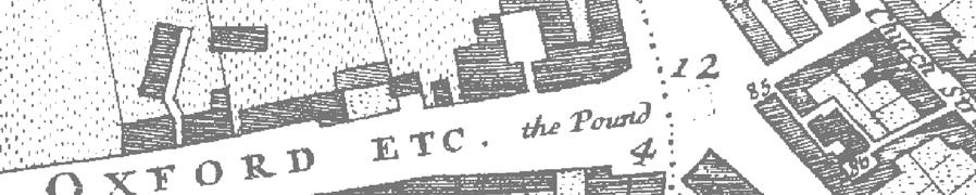
10 MOLA 2010 Greater London!. the site the site!. 0 City of Westminster Tottenham 10km 0 Court Road Station 500m Su CR ST GILES' CIRCUS nsport) (London Tra 7 Posts m TCBs Centre Point Flag Staffs to 15 Subway 1 TCPs C FAL S ER ON B EW C FAL 1 63 GM 165 T GC 12 W y RO E D 135a ROA a 21 sb y Pre M AC hu N DE K AR PL 138 CC rch 140 's R SS CRO RING CHA 143 k atric St P 144 LB Bd N TO 146 n st & 21 T SU Crossrail Eastern Ticket Hall (TCR) site 9 7 TCBs o Asly C 5 TCBs t, GL m 11 3 Cons E Boro 80150/36075 Astoria Theatre ST ORDE EW B ANDR 15 BER ON Pool 1 to 22 LB m Scale A ORA 26 of use Ho b as T h e ar na o St B S oh -in /36000 Reproduced from the Ordnance Survey material with the permission of Ordnance Survey on behalf of the Controller of Her Majesty's Stationery Office Crown Copyright. Unauthorised reproduction infringes Crown copyright and may lead to prosecution or civil proceedings. Tfl N DE TCBs E PH 3 to S 12 Goslett Yard site LB GO D Bank AR TY L ET 25m Fig 1 Site location CAMD1144WB10#01 M
11 MOLA 2010 Sutton Row 12 Charing Cross Road / the site a Goslett Yard 80150/36008 Reproduced from the Ordnance Survey material with the permission of Ordnance Survey on behalf of the Controller of Her Majesty's Stationery Office Crown Copyright. Unauthorised reproduction infringes Crown copyright and may lead to prosecution or civil proceedings. Tfl Fig 2 Location of targeted watching brief 0 10m CAMD1144WB10#02

12 Fig 3 View of site from Centre Point, looking West 7 p:\camd\1144\tcg09\field\targetedwatchingbriefnov10.doc
13 8 Results of the targeted watching brief th 20th century industrial structures At the first significant horizon a sequence of brick structures dating to the 19th and early 20th centuries was revealed. Previous recording of standing buildings in the vicinity and associated documentary research indicated that the site formed part of the industrial complex of the Victorian enterprise Crosse & Blackwell at this time. The potential for associated buried structures had been confirmed in the field evaluation and this phase was one of the key objectives of the TWB. These structures included the brick walls and wooden floors of the factory buildings, cellars, a circular bricklined furnace and a machine base. A brass plate on the machinery is for J & E Hall Ltd, a company established in Dartford since the 18th century and pioneers of early refrigeration equipment. A brick vaulted chamber in the central area of the site, possibly beneath an open yard had been carefully lined with cement and is interpreted as a cistern, also associated with the Crosse & Blackwell works. When it went out of use it was backfilled with late 19th century ceramic containers for their products. Large assemblages of Crosse & Blackwell pottery and glass vessels were present within this and other features. A MOLA pottery specialist was present on site to log and sample this material Early 20th century features Early 20th century features OD Level (Top) Preliminary interpretation and date Ash and clinker [34] 24.72m OD Levelling deposit for concrete slab Sandy silt and pottery [43] 24.57m OD Levelling deposit When Crosse & Blackwell departed in 1925 the warehouse buildings that occupied the site were redeveloped. The buildings were part demolished and replaced with a building constructed of brick with steel joists, concrete foundation pads and concrete slab floors. In the north-west area of the site, levelling deposits [34] and [43] recorded beneath the concrete slab and overlying earlier warehouse floors (Sec 8.1.3) contained large quantities of Crosse & Blackwell pottery dating to between 1900 and In the north-east area of the site a 20th century brick and concrete plinth for a machine base was recorded (Fig 4). This included a brass plate on the machine base for J & E Hall Ltd, a company established in Dartford since the 18th century and pioneers of early refrigeration equipment. It is possible that this represents part of a purpose-built early 20th century cold store with slate-lined walls associated with a later phase of the Crosse & Blackwell works. Another interpretation is that as J & E Hall Ltd are listed as also having produced lift equipment, it is possible that the machinery recorded is part of a lift mechanism for an elevator noted on the 1st floor plan of the previous standing building (MOLA 2009, A Standing Buildings Report, Fig 11). 8 p:\camd\1144\tcg09\field\targetedwatchingbriefnov10.doc
 Preliminary interpretation and date Circular, concave brick lined pit [45] 24.")
14 Fig 4 View of 20th century machine base, looking East th century circular brick lined pit and associated trenches 19th century industrial sequence OD Level (Top) Preliminary interpretation and date Circular, concave brick lined pit [45] 24.12m OD Possible furnace or chimney base Brick lined trench [47] 24.08m OD Possible flue Brick lined trench [48] 24.10m OD Possible flue Brick floors [41], [42], [49] and [138] m OD Possible industrial furnace, kiln or boiler room floors In the northern area of the site a large room constructed entirely of firebricks dating from the mid to late 19th century was recorded. This structure contained a circular brick lined pit [45] that may be part of a furnace base, chimney base or similar, two parallel running large rectangular brick trenches [47] and [48] that may represent a flue system and floors [41], [42], [49] and [138] (Fig 12). The structures were substantial enough to suggest they are of an industrial nature and represent part of the Crosse & Blackwell enterprise that occupied the site at this time. At one stage in the structures usage the circular pit was halved in size [146] (Fig 5) and the two brick lined trenches were also much reduced in length with the addition of internal walls [139] and [160] and being partially backfilled by rubble deposits [147], [148] and [146]. This suggests the structures were linked in their usage and that the alterations may represent a degree of downsizing or re-use. An interesting collection of firebricks of various forms were recorded in the backfills (Fig 6), suggesting some structures were demolished down to floor level. 9 p:\camd\1144\tcg09\field\targetedwatchingbriefnov10.doc

15 Although the fabric and forms of these building materials suggest kiln, oven or furnace structures there is little evidence, apart from the presence of soot deposits, for their being exposed to high heats during their use. Brick lined pit [45] is the only structure that shows evidence for the exposure to high heat temperature. The material from context [148] comprises of various shapes of firebrick used principally in kiln construction and what may be kiln shelving made from the same material and manufactured by E J & J Pearson Ld, Stourbridge, West Midlands. Firebricks from this manufacturer were found during the first phase of evaluation and date from 1852 to around Fig 5 View of brick lined pit [45], looking North 10 p:\camd\1144\tcg09\field\targetedwatchingbriefnov10.doc
 Preliminary interpretation and date Iron plated floor [35] 24.")
16 Fig 6 Sample of firebricks taken from context [148] Warehouse floors and associated features Warehouse floors and associated features OD Level (Top) Preliminary interpretation and date Iron plated floor [35] 24.58m OD Warehouse floor Timber floor [37] 24.37m OD Warehouse floor Two phases of flooring associated with the Crosse & Blackwell warehouses were recorded in the north-west area of the site (Fig 7). Floor [35] consisted of re-used heavy iron plates resting on timber joists. Although only fragments of this floor survived later development it is evident that it would have originally provided a substantially hard wearing work surface. The iron plates originate from a previous industrial use possibly associated with the firebrick structures recorded in the eastern half of the site (Section 8.1.2). The underlying levelling deposit for this [36] was predominately made up of an extensive assemblage of Crosse & Blackwell fragmented glass, ceramic and stoneware food vessels and a large quantity of glass stoppers dating to between 1870 and Beneath this the remains of a timber floor [37], composed of softwood planks aligned north south on timber joists, was recorded that represents an earlier probably late 19th century phase of warehousing. 11 p:\camd\1144\tcg09\field\targetedwatchingbriefnov10.doc
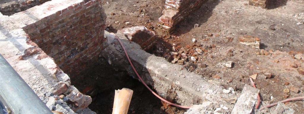
![Fig 7 View of,warehouse floors [35] and [37], looking North 8.1.4 Brick vaulted cistern Brick vaulted cistern OD Level Preliminary (Top) interpretation and date Brick vaulted chamber [104] 24.](/docs-images/94/120365378/images/17-0.jpg "57m OD Cistern A brick vaulted chamber [104] in the central area of the site (Figs 8-10), had been carefully lined with cement and is interpreted as a cistern, also associated with the Crosse &")
![Blackwell works. When it went out of use it was backfilled with late 19th century ceramic containers for their products [131] and [149]. A large percentage of this pottery was sampled.](/docs-images/94/120365378/images/17-1.jpg "Context [149], the undisturbed fill of the cistern under [131] contained the most pottery with over 2.7 tonnes of ceramics dumped here (Fig 10).")
17 Fig 7 View of,warehouse floors [35] and [37], looking North Brick vaulted cistern Brick vaulted cistern OD Level Preliminary (Top) interpretation and date Brick vaulted chamber [104] 24.57m OD Cistern A brick vaulted chamber [104] in the central area of the site (Figs 8-10), had been carefully lined with cement and is interpreted as a cistern, also associated with the Crosse & Blackwell works. When it went out of use it was backfilled with late 19th century ceramic containers for their products [131] and [149]. A large percentage of this pottery was sampled. Context [149], the undisturbed fill of the cistern under [131] contained the most pottery with over 2.7 tonnes of ceramics dumped here (Fig 10). The majority is of the largest sized grooved whiteware jar form with c10,000 of these vessels present. Again representing a large clear out of Crosse & Blackwell s stock, the range of stoneware stamps from Charles Bailey s operation of the Fulham pothouse during (Green 1999) indicate that much of this material was made and used during the last quarter of the 19th century. A large proportion of the pottery in this context was collected, with only the voluminous quantities of grooved jar body sherds not subject to stringent retrieval. The cistern fits within the footprint of a large property seen on the Ordnance Survey map of 1871 (Fig 14) which suggests it may be associated with this, although it could also be of an earlier date and lie possibly beneath an open yard. Before and during the second half of the 19th century, a period when Crosse & Blackwell began acquiring properties for development other commercial activities existed on the site and it is possible that this vaulted chamber could have been associated with a previous occupant. 12 p:\camd\1144\tcg09\field\targetedwatchingbriefnov10.doc
18 Fig 8 View of vaulted cistern [104], looking North-West 13 p:\camd\1144\tcg09\field\targetedwatchingbriefnov10.doc
19 Fig 9 View of site looking North-East, showing 19th century fire brick structures, vaulted cistern and 17th - 18th century cellar with arch roofed alcove 14 p:\camd\1144\tcg09\field\targetedwatchingbriefnov10.doc
![Fig 10 Crosse & Blackwell pottery collection within cistern [104] 8.1.5 19th century Building foundations 19th century building foundations OD Level (Top) Brick walls [80], [82], [96] and [97] 24.](/docs-images/94/120365378/images/20-0.jpg "52m 24.")
20 Fig 10 Crosse & Blackwell pottery collection within cistern [104] th century Building foundations 19th century building foundations OD Level (Top) Brick walls [80], [82], [96] and [97] 24.52m 24.79m OD Preliminary interpretation and date 19th-20th century building foundations The Ordnance Survey map of 1871 (Fig 14) shows the south-west corner of the site is occupied by a group of four individually outlined properties on the corner of George Yard (later Goslett Yard), which may have housed small manufacturers with independent workshops. The alignment of the 19th-20th century buildings follow those of the previous occupation across the site. This can be seen in the western half of the site where a number of walls, associated drainage and foundations (Fig 13) were built directly onto the remains of the demolished 17th-18th century structures. Walls [80], [82], [96] and [97] may represent the two southern properties fronting onto George Yard (Fig 11). A brick culvert [85] was recorded running along the perimeter of the site that may represent associated drainage. 15 p:\camd\1144\tcg09\field\targetedwatchingbriefnov10.doc
21 A narrow alleyway can be seen running between the south-west corner property and the northern properties on the Ordnance Survey map of 1871 (Fig 14) and also Ordnance Survey maps of 1894 and 1914 (not re-produced here). This may be the narrow space seen between walls [80] and [106] (Figs 13-14). A circular brick feature [79] was recorded within this open area which may represent a drainage feature such as a soak-away (Fig 11). A further series of walls and features were also recorded beneath the modern concrete slab that may represent a third, large property to the immediate north. Walls [60], [65], [68], [75], and [76] represent the northern wall of this property and were built directly on top of the property line and southern wall of an underlying 17th to eighteenth century cellar [121]. The walls, foundations and drainage features recorded within this area may be associated internal features and additions. Walls [103], [106], [100] and [143] may be part of the southern section of this property. Fig 11 View of 17th - 19th century wall foundations and circular soak-away in southern area of site, looking East 16 p:\camd\1144\tcg09\field\targetedwatchingbriefnov10.doc

22 Fig 12 View of 19th century wall foundations in south-west corner of site, looking South-West 17 p:\camd\1144\tcg09\field\targetedwatchingbriefnov10.doc
23
24
25 8.2 17th 18th century structures Beneath the 19th 20th century buildings and features including those associated with the Crosse & Blackwell development, the brick walls, foundations and drainage of 17th 18th century properties fronting onto Bow Street and George Yard (now Goslett Yard) were recorded (Fig 15). These features can be related to historic maps of the period (Fig 16) and included a brick floored cellar with vaulted alcove recorded in the north west of the site. Development began in the 1670s and it can be seen that by 1682 Soho Square and adjoining streets were laid out and (partially) built up (Fig 16). An integral part of the development was the street marked as Bow Street, parallel to and just to the east of Soho Square. The southern part of this street, however, was known as George Yard (now Goslett Yard) and the buildings on its west side comprised the stables and coach houses for the grander houses fronting Soho Square (SoL 81,82). This northsouth street was broken by at least the mid-18th century but the northern arm is still represented by Falconberg Mews. The road crossing Bow Street - Giles Street - is now Sutton Row. Buildings on the east side were almost certainly smaller domestic properties whilst the square left in the centre bounded by other properties facing Crown Street (now Charing Cross Road) to the east was clearly back yards or gardens. It is therefore likely that the walls found during the investigation represent the original structures on the east side of Bow Street/George Yard. 20 p:\camd\1144\tcg09\field\targetedwatchingbriefnov10.doc
26
27
28 th 18th century cellar 17th 18th century cellar OD Level (Top) Preliminary interpretation and date Walls [91], [107] and [121] 24.12m 17th 18th century cellar 24.36m OD Brick floor [133] 22.57m OD 17th 18th century cellar floor Brick arch [88] 24.20m OD 17th 18th century Internal arch roofed alcove Walls [107], [121] and [91] form the west, south and east walls of a 17th-18th century cellar with brick floor [133] and an internal arch-roofed alcove [88] abutting the eastern back wall [91] (Figs 17-18). The cellar shows signs of being in use through both the eighteenth and perhaps 19th centuries. An additional wall [120], which forms an internal western wall of the cellar, appears to have a recess that was bricked up at a later date with a possible 18th century wall [125]. This feature may have been for an entrance way, light well or similar. A later stairway [124] was recorded in the southern wall [121] of the cellar with the addition of a brick supporting plinth to the immediate west of this entranceway and abutting the internal face of cellar wall [121], (Fig 19). These later additions are evidence that the cellar remained in use into the 19th century. Fig 17 View of Internal arch-roofed alcove [88], looking East 23 p:\camd\1144\tcg09\field\targetedwatchingbriefnov10.doc
29 Fig 18 View of cellar floor [133], looking East Fig 19 View of stairway addition [124], looking South 24 p:\camd\1144\tcg09\field\targetedwatchingbriefnov10.doc
30 Fig 20 View of cellar wall [121] and later cistern [104], looking North-East th 18th century buildings and associated features 17th 18th century buildings and associated features OD Level (Top) Preliminary interpretation and date Tile surface [112] 23.70m OD Tiled floor surface Brick drains [110] and [115] 23.56m OD Brick lined drains associated with 17th 18th century properties Brick wall [158] 23.97m OD 17th 18th century property wall Brick walls [81], [95] and [99] 24.20m 24.32m OD 17th 18th century properties Brick walls [144] and [159] 24.07m OD 17th 18th century property To the west of the cellar a brick drain with ragstone slab capping [115] was recorded running parallel and abutting wall [107]. To the south this drain was built into the north face of wall [158], probably for a down drain pipe, and in the north the drain continued beneath a tiled floor surface [112]. In the north there was a junction with an east- west running brick drain [110] which was truncated to the west by 20th century buildings. A main structural wall [158], the probable continuation of property wall [121] also continued west beyond the limit of excavation until truncated by 20th century buildings, which suggests the original building may have continued westwards beyond the limit of excavation. 25 p:\camd\1144\tcg09\field\targetedwatchingbriefnov10.doc
31 To the south of this, walls [159] and [144] represent the remains of a 17th-18th century building without cellar that also fronts onto the east side of Bow Street (now Goslett Yard). Wall [102], which continues west beyond the limit of excavation, may be a later soakaway or cess pit with associated brick drain [101]. A later brick culvert [69] was also recorded in this area. Walls [81], [95] and [99] represent the remains of 17th-18th century properties fronting onto the southern section of George Yard including the corner building of Bow Street and Georges Yard (Fig 15). These three wall foundations truncate large levelling deposits [98], [105] and [119] down to natural gravel [137] but show no evidence that these properties were cellared. Pottery sherds date these levelling deposits to between 1650 and 1700 and fragments of clay tobacco pipes date to between 1680 and 1710 which suggests the construction of the buildings is of a late 17th century date. 8.3 Pre-urbanisation The area of the site was known as Soho Fields, comprising 22 acres, from an early date and remained open ground until the mid 17th century. Our site lies in the northeast corner of this area, just to the west of Hog Lane (later Crown Street and now Charing Cross Road) which formed the boundary between the ancient parishes of St Martin in the Fields to the west and St Giles in the Fields to the east Post-Medieval levelling deposits Post-Medieval levelling deposits OD Level (Top) Preliminary interpretation and date Deposits [98], [105] and [119] 23.76m OD Late 17th century levelling deposits At the second main archaeological horizon the post-medieval buildings had cut into 17th century levelling deposits [98], [105] and [119]. These represent the general dumping of post-medieval demolition material and infill prior to development. Deposit [98] contained pottery sherds dating to between 1650 and 1700 and clay tobacco pipes dating to between 1680 and These deposits may have originally have covered a large area but were recorded mainly in the southern part of the site having been completely truncated in the north by basements and in the east by substantial brick foundations relating to the 19th century Crosse & Blackwell development. 26 p:\camd\1144\tcg09\field\targetedwatchingbriefnov10.doc
32 8.3.2 Post-Medieval quarrying Post-Medieval quarrying OD Level (Top) Preliminary interpretation and date Clayey, sandy silt [129] Late 18th century soil 22.77m OD Clayey, sandy silt [151] 22.47m OD Late 18th century soil A uniform part-waterlain deposit of dark sandy silt [129], becoming more clayey and humic with depth, was recorded as the lowest archaeological level across the site, beneath these infill deposits (Fig 21). This deposit contained pottery sherds dating to between 1670 and 1720 and clay tobacco pipes dating to between 1680 and An underlying mid dark grey/brown clay sandy silt [151] that represents a dumping/levelling layer was also recorded. These two deposits represent a postmedieval rudimentary soil layer developing within an area of extensive but shallow open-cast brickearth quarrying prior to backfill and construction activity in the 17th century through a mixture of dumping, soil development and bioturbation. The absence of brickearth; the relatively low level and uniform truncation of the underlying terrace gravel and the presence of post-medieval finds in these deposits all support this hypothesis. There was therefore no evidence of an original soil profile or associated prehistoric, Roman or medieval features. The evidence suggests that the quarrying had already removed this horizon across the site and that the TWB has answered this question. The dating of these deposits and the closely dated overlying levelling deposits suggest the urbanisation of the area followed closely after quarrying in the late 17th century. This confirms the chronology of the first urbanisation of the area, as first indicated from historic maps. Fig 21 View of South-West corner of site, showing pre-urbanisation deposit [129], looking South 27 p:\camd\1144\tcg09\field\targetedwatchingbriefnov10.doc
33 8.4 Natural deposits Natural geology sequence OD Level (Top) Preliminary interpretation and date Silt and gravel [140] 22.75m OD Truncated natural Sandy gravel [137] 22.15m OD Truncated terrace gravels Context (140), recorded at heights of between 22.15m and 22.75m AOD), was a greeny grey silt with fine rootlines, moderately frequent gravel throughout with associated iron staining and fissures filled with silts from above. Interestingly the fissures in [140] could indicate a period of drying out prior to the accumulation of [129] over [140]. Furthermore, the fine rootlines indicate vegetation (although probably light) did take hold on or over [140]. The sediments of this context were considered to be the remnants of a truncated and trampled area probably as a result of quarrying activity Context [137], although not sampled in either monolith or bulks was the river terrace gravels underlying the whole site and consisted of compact, orange, heavily iron stained sands and sub-rounded to sub-angular gravels (Figs 22-23). This context undulated across the site but lay some 0.4m below the monolith sample at approximately 22.15m AOD. The gravels are a Pleistocene deposit and form the basis to the Holocene sequence of deposits that is of interest both archaeologically and palaeo-environmentally. 28 p:\camd\1144\tcg09\field\targetedwatchingbriefnov10.doc
34
35 Fig 23 View of South-West corner of site showing natural gravel deposit [137], looking South-West 30 p:\camd\1144\tcg09\field\targetedwatchingbriefnov10.doc
36 9 Assessment of results against original expectations and review of targeted watching brief strategy GLAAS guidelines (English Heritage, 1998) require an assessment of the success of the investigation in order to illustrate what level of confidence can be placed on the information. The recommendations suggest that there should be: Assessment of results against original expectations (using criteria for assessing national importance of period, relative completeness, condition, rarity and group value)... (Guidance Paper V, 4 7) Department of the Environment guidelines for assessing the importance of individual monuments for possible Scheduling include the following criteria: Period; Rarity; Documentation; Survival/Condition; Fragility/Vulnerability; Diversity; and Potential. The guide lines stresses that these criteria should not...be regarded as definitive; rather they are indicators which contribute to a wider judgement based on the individual circumstances of a case. Criterion 1: period Taken as a whole, the archaeological deposit sequence is largely characteristic of the 17th to early 20th centuries. The results of the investigation confirm historic map evidence with the first urbanisation consisting of 17th century structural remains with further phases of building development in the 18th, 19th and early 20th centuries. The 17th and 18th century structures were associated with properties fronting onto Bow Street and George Yard (now Goslett Yard) and include a brick cellar with vaulted arched alcove, wall foundations and drainage. The later 19th and 20th century structures include building walls and foundations, possible furnace or kiln structures and warehouse floors associated with the commercial and industrial occupation of the site. Of particular interest was a vaulted chamber interpreted as a cistern which had been filled with a significant assemblage of ceramic and glass vessels when the structure went out of use. These are associated with the Victorian company, Crosse and Blackwell, which is known to have occupied the site until the 1920 s. This urbanisation was preceded by (and perhaps associated with) quarrying of the brickearth deposit for brick manufacture. Criterion 2: rarity The post-medieval urbanisation has some local rarity, in that the predictive deposit survival modelling carried out by MOLA for the Tottenham Court Road/Tottenham Court Road Station Upgrade sites indicates that the majority has been removed by modern basements. However, these remains are still unlikely to be of more than local significance (excluding the Crosse and Blackwell element). The accumulation of so much late 19th century industrial pottery within the site is certainly unusual. However, this is likely to be rare only in a regional context. Criterion 3: documentation There are surviving documentary records for remains in the area from what appears to be the earliest development of the site in the 17th century onwards. In particular, there is considerable contemporary documentation for the later 19th century occupation of the site by Crosse & Blackwell Ltd. 31 p:\camd\1144\tcg09\field\targetedwatchingbriefnov10.doc
37 Much of this documentation may well be specific enough to relate to individual properties and features. Criterion 4: group value The earliest archaeological remains on the site appear to relate to uniform development of the wider area in the 17th century. By the end of the 19th century much of the site was part of the larger premises of Crosse and Blackwell Ltd. There is a group value in that the site-specific remains can probably be set within a wider area context, from both archaeological and historical data sources. Criterion 5: survival/condition The targeted watching brief has demonstrated that archaeological remains survive well on the site, despite the intrusive construction of the existing building over and through them. The good state of preservation is largely due to the absence of a basement within that building. Thus, for example, the survival of a wooden floor and pottery spread (some vessels with preserved paper labels) may be considered very unusual in urban conditions. Criterion 6: diversity Given its consistency, state of preservation and potential group value it is likely that the classes of 17th-19th century urbanisation across the site are representative of land uses within the surrounding area. Diversity would be represented mainly by possible changes in ownership and land use, e.g. from a 17th century residential layout to 19th century industrialisation. Criterion 7: potential The potential of the site appears to be associated with development of a previously open area from the 17th century. Land usage within this time frame seems to have shifted from domestic to industrial and commercial by the 20th century. The results of the targeted watching brief and previous evaluation have provided a great amount of detail as to the occupation of the area from the 17th century onwards. The potential for future study to investigate documentary evidence of industrial and commercial activity and to match this to the findings would help to clarify the exact function of industrial features such as the 19th century circular pit, trenches and furnace or kiln ware recorded on the site. The earlier 17th to 18th century buildings and the later alterations into more commercial properties will add greatly to the understanding of these transitional periods of urbanisation with the potential of comparison to the results of previous and future works in the local area. The site has also provided information of how the area would have appeared just prior to this urbanisation and how wide scale brickearth quarrying had removed evidence of any previous occupation or activity on the site. Deposits recorded overlying natural represent a rudimentary soil layer developing over quarried ground prior to the construction activity in the 17 th Century. These deposits have been sampled and there is potential of future work on these which may provide information of whether the land cultivated for a short time rather than just waste ground. A better understanding of the natural stratigraphy and vegetation of the site is likely to have local significance, as it would help to reconstruct the past landscape characteristics of the area prior to development of the 17 th Century. 32 p:\camd\1144\tcg09\field\targetedwatchingbriefnov10.doc
38 10 Statement of potential archaeology The Targeted Watching Brief successfully achieved the objectives set out in the Method Statement (Crossrail Version 2, June 2010) with regard to understanding the post-medieval building sequence and the nature of the underlying pre-urban landscape. The investigation has suggested significant potential for correlating the recording of buried structures and standing buildings now demolished, with historic documentary sources and finds assemblages on the Goslett Yard and adjacent sites. The whole area between Charing Cross Road and Soho Square was extensively occupied by the Crosse and Blackwell industrial complex, which adapted and extended earlier buildings. Both this firm and the refrigeration pioneers J & E Hall are still extant and may have supporting archives. The archaeological remains are assessed as of local significance in terms of the development of this part of London increasing to regional significance in the case of industrial remains associated with Crosse and Blackwell because of the comparative potential with documentary evidence. 11 Conclusions 11.1 Geology The earliest deposit recorded on the site was context [137], the river terrace gravels underlying the whole site and consisted of compact, orange, heavily iron stained sands and sub-rounded to sub-angular gravels (Figs 22-23). This context undulated across the site at approximately 22.15m AOD. The gravels are a Pleistocene deposit and form the basis to the Holocene sequence of deposits. This deposit was truncated from above by quarrying activity. Overlying this was context (140), recorded at levels of between 22.15m and 22.75m AOD, was a greeny grey silt with fine rootlines, moderately frequent gravel throughout with associated iron staining and fissures filled with silts from above. Interestingly the fissures in [140] could indicate a period of drying out prior to the accumulation of overlying silt deposit [129]. Furthermore, the fine rootlines indicate vegetation (although probably light) did take hold on or over [140]. The sediments of this context were considered to be the remnants of a truncated and trampled area probably as a result of quarrying activity th century land use The brick walls, foundations and drainage of 17th 18th century properties fronting onto the east side of Bow Street and George Yard (now Goslett Yard) were recorded (Fig 15). These features, which were recorded beneath the 19th 20th century buildings and features including those associated with the Crosse & Blackwell development, can be related to historic maps of the period (Fig 16) and included a brick floored cellar with vaulted alcove recorded in the north west of the site. The area of the site was known as Soho Fields, comprising 22 acres, from an early date and remained open ground until the mid 17th century. Our site lies in the north- 33 p:\camd\1144\tcg09\field\targetedwatchingbriefnov10.doc
39 east corner of this area, just to the west of Hog Lane (later Crown Street and now Charing Cross Road) which formed the boundary between the ancient parishes of St Martin in the Fields to the west and St Giles in the Fields to the east. Development began in the 1670s and it can be seen that by 1682 Soho Square and adjoining streets were laid out and (partially) built up. An integral part of the development was the street marked as Bow Street, parallel to and just to the east of Soho Square. The southern part of this street, however, was known as George Yard (now Goslett Yard) and the buildings on its west side comprised the stables and coach houses for the grander houses fronting Soho Square (SoL 81,82). This northsouth street was broken by at least the mid 18 th century but the northern arm is still represented by Falconberg Mews. The road crossing Bow Street - Giles Street - is now Sutton Row. Buildings on the east side were almost certainly smaller domestic properties whilst the square left in the centre bounded by other properties facing Crown Street (now Charing Cross Road) to the east was clearly back yards or gardens Later development 19th-20th century walls, foundations and drainage features were recorded across the site that represent properties fronting onto the east side of Bow Street and George Yard (later Goslett Yard). The alignment of the 19th-20th century buildings follow those of the previous occupation across the site. This can be seen in the western half of the site where a number of walls, associated drainage and foundations (Fig 13) were built directly onto the remains of the demolished 17th-18th century structures (Sec 8.1.5). The Ordnance Survey map of 1871 (Fig 14) shows the south-west corner of the site is occupied by a group of four individually outlined properties on the corner of George Yard (later Goslett Yard), which may have housed small manufacturers with independent workshops. The walls recorded during the targeted watching brief of this date in the western half of the site may represent these properties th century industrial development David Sorapure Two phases of warehouse floors were recorded in the north-west of the site. The levelling deposits of these floors can be directly related to the Crosse & Blackwell works that occupied the site from the 19th to early 20th centuries. A large brick lined cistern, backfilled in the late 19th century with pottery from the same Crosse & Blackwell occupation of the site is also probably associated with these works. In the eastern half of the site a circular kiln, furnace base or similar with associated floors and two brick lined rectangular trenches all constructed of fire bricks on substantial foundations was recorded. This structure dates to the 19th century and represents an industrial process associated with the Crosse & Blackwell works. The new, wider Charing Cross Road opened in and shortly after Messrs Crosse and Blackwell had expanded their food manufacturing business to the site of the Astoria, on the northern side of Sutton Row, then called Sutton Street. The site can be seen to the south of this warehouse building on the 1871 OS map not illustrated). The small yard off Sutton Street, behind the Roman Catholic Chapel (St Patrick s) to the north of the site, was present by this date. This survival as an open space reflects the persistence of property divisions and indicates the growth of 34 p:\camd\1144\tcg09\field\targetedwatchingbriefnov10.doc
40 Crosse and Blackwell within the site, involving the gradual acquisition and piecemeal development of smaller units of property by the company, rather than one redevelopment all at once. Development, function and occupants of the standing buildings Crosse & Blackwell acquired their first premise at No.20 Soho Square in 1858 and the growing success of their enterprise led to successive acquisitions of neighbouring properties. (SoL 33, 34). The company s development contributed to the architectural character of the area bounded by Soho Square to the west, Goslett Yard to the south, Charing Cross to the east and Falconberg Court to the north; Industrial premises became the norm built of stock bricks, 2-3 storeys high with loops, large windows and sometimes a striking difference between the imposing façade on Charing Cross and the stricter functionalism of the rear. An inventory of goods of 1868 provides evidence of the possessions of the Crosse & and Blackwell in properties on Sutton Place, George Yard (now Goslett Yard), Denmark Street, Stacey Street, Dean Street and Earl Street. The list for George Yard included: a single purchase crab crane, with wrought iron and apparatus; two wire sieves; an iron pan with brick setting and furnace and earthen flue; the water supply pipe from Company s main with cocks; a length of India rubber tube; four washing tubs and stands under; the enclosure of copper and glass bin; the enclosure of room adjoining; a stepping stage; 3 double gas burners; two single do. (LMA 1868 p.75) Amongst properties located on Sutton Street the inventory mentions a cooperage, along with smiths shop, a dry cask warehouse, and the basket and makers room, all workshops associated with the storage and distribution of foodstuffs. These had replaced earlier activities on the site, listed in the 1841 postal directory as a shaft and timber bender at No 5 and a locksmith at No 9 whose workshops and tools could have been firstly purchased by the Crosse & Blackwell and only later redeveloped as company warehouses. By 1877 Crosse and Blackwell had commissioned the architects R.L. Roumieu and A. Aitchinson to build new warehouse buildings and stables. The postal directory of 1882 has a gap in its listing between 14 Crown Street (to the north of Sutton Street) and 26 Crown Street (to the south of Sutton Street). The omission of warehouses from postal directories is understandable as they were not residential addresses and post to the Crosse and Blackwell Company would have gone to their Soho Square offices. However the new development was not without its problems. Shortly after work began R.L Roumieu died but his son R.A. Roumieu completed his designs. Complaints were raised about the height of the building and construction was not completed until Entries in the 1882 post office directory, at a time when the new warehouse on the site were perhaps still under construction note a mixture of shops, businesses and small scale manufacturers. However, the ownership of these properties is obviously not indicated by the postal directories, only the occupancy, so it could be conjectured that Crosse and Blackwell may have gradually acquired the ownership of these smaller business premises, ready for further expansion in the future when conditions allowed. The 1894 OS map (not reproduced here) shows the Crosse and Blackwell building on the southern side of Sutton Street linked to that on the northern side by a small bridge over the street. The northern building is itself linked by a similar structure to number 20 Soho Square, which again is linked to another building on the corner of Falconberg Court. Small business premises, presumably shops, are shown fronting 35 p:\camd\1144\tcg09\field\targetedwatchingbriefnov10.doc
41 onto the new and wider Charing Cross Road, as there are today. The open area to the north of the site, east of St Patrick s Church, is clearly visible. The standing building over the site appears as a separate property on the corner of George Yard, although by this time St Patrick s Church had expanded to its present size and shape and the Crosse and Blackwell warehouse appears to cover part of the site. The 1899 postal directory documents how Crosse and Blackwell warehouses were located alongside smaller manufacturers and shops Charing Cross Road, forming the south-eastern corner of the site was constructed in 1905 replacing the previous individual shops. Crosse and Blackwell s business continued to expand before and after the 1st World War with mergers and acquisitions and in the 1920s the company grew with a national transportation network including warehouses, and depots across the country Charing Cross Road was converted to showrooms in between (Pevsner, 2003, 403), and this probably resulted in the first remodelling of the façade of the former warehouse. The conversion of the warehouse also saw the provision of new retail units on the ground floor, fronting Charing Cross Road. 12 Publication and dissemination proposals It is recommended that the results of the targeted watching brief at 12 Goslett Yard be integrated with results that extend beyond the 12 Goslett Yard site on other Crossrail sites (such as the Tottenham Court Road Station Upgrade Development, Crossrail Eastern Ticket Hall site and Crossrail West Contract) in order to take into account the complex development of the Crosse and Blackwell industrial sites in this part of London. 13 Archive deposition The site archive containing original records and finds will be stored temporarily with MOLA pending a future decision over the longer-term archive deposition and public access process for the wider Crossrail project. 14 Bibliography Askey, D, 1998 Stoneware bottles, 2nd edition, Elsecar Heritage Centre, near Barnsley Atkinson, D R and Oswald, A, 1969 London clay tobacco pipes, J British Archaeol Assoc 32, Bell, R.C, 1986 Maling and Other Tyneside Pottery, Shire Publications Crossrail Version 2, June 2010, Method Statement for Targeted Watching Brief, Crossrail Eastern Ticket Hall (TCR),12 Goslett Yard Crossrail, January 2009, Multi-Disciplinary Consultant Works Package 2, Tottenham Court Road Station Site Specific Archaeological Scheme of Investigation (CR-SD- TCR-EN-OT-00001); 36 p:\camd\1144\tcg09\field\targetedwatchingbriefnov10.doc
42 Crossrail, June 2009, Archaeology Specification for Evaluation & Mitigation (including Watching Brief) (Document Number: CR-PN-LWS-EN-SP-00001); Davey, P 1997 Clay pipes from Bolsover church, unpublished archive report English Heritage, 1991 Management of Archaeological Projects (MAP2) English Heritage Greater London Archaeology Advisory Service, June 1998 Archaeological Guidance Papers 1-5 English Heritage Greater London Archaeology Advisory Service, May 1999 Archaeological Guidance Papers 6 Green, C, 1999 Fulham Pottery excavations , English Heritage Higgins, D A and Davey, P, 1994 Draft guidelines for using the clay tobacco pipe record sheets, unpublished report Institute for Archaeologists, (IFA), 2001 By-Laws, Standards and Policy Statements of the Institute for Archaeologists, (rev. 2001), Standard and guidance: field evaluation Institute for Archaeologists (IFA), supplement 2001, By-Laws, Standards and Policy Statements of the Institute for Archaeologists: Standards and guidance the collection, documentation conservation and research of archaeological materials McGee, October 2009, Tottenham Court Road LU, Construction Phase Plan (Document No CPHSP-004) McGee, December 2009, Tottenham Court Road Station Upgrade, Method Statement for MOLAS Excavations in Goslett Yard (Document No MS087) MOLA, January 2010, Crossrail Eastern Ticket Hall, 12 Goslett Yard, London WC2: An archaeological evaluation report MOLA, November 2009, Tottenham Court Road, Crossrail Eastern Ticket Hall, 12 Goslett Yard, London WC2, A method statement for archaeological evaluation MOLA, July 2009, Tottenham Court Road, Crossrail Eastern Ticket Hall, Goslett Yard, London WC2, Archaeological Deposit Survival Plan MOLA, 2009, Tottenham Court Road Station Upgrade. London Borough of Camden and London Borough of Westminster; A standing building survey report. MOLA, 2009 Building material, St Giles Court, St Giles high Street, WC2 (SIC06) Museum of London, 1994 Archaeological Site Manual 3rd edition Museum of London, 2002 A research framework for London archaeology 2002 Pearson, L, 2005 Tile Gazetteer, Shepton Beauchamp Pevsner Bradley, S & Pevsner, N, 2003, The Buildings of England. London 6: Westminster, Yale University Press. Oswald, A, 1975 Clay pipes for the archaeologist, BAR 14, Oxford 37 p:\camd\1144\tcg09\field\targetedwatchingbriefnov10.doc
43 Smith, T P, 2008 Some sources of fireclay bricks used in London, Information (J British Brick Soc) 106, Survey of London, Volume XXXIII; The Parish of St Anne Soho, University of London / Greater London Council, Acknowledgements The author and MOLA would like to thank Will Peters (LU Section Manager) and all staff at London Underground and Mike Curran (Site Manager) and all staff at BAM Nuttall Ltd for their co-operation and assistance during this project. The author and MOLA would also like to thank John Brown (English Heritage Archaeological Planning Officer) and J. Carver (Crossrail Project Archaeologist). The investigation was supervised by the author with the assistance of Antonietta Lerz, Steve Turner, Simon Stevens, David Harrison, Steve White, Vince Gardiner, Mark Wiggins, Richard Hewett and Valeria Boesso. Other MOLA staff who were involved in the project were Nigel Jeffries (pottery), Sarah Jones and Gideon Simmons (surveying), Maggie Cox (photography), Graham Srurr (geoarchaeology) and Dave Sorapure (buildings). The MOLA Senior Contracts Manager was George Dennis and the Contract Manager was Elaine Eastbury. 38 p:\camd\1144\tcg09\field\targetedwatchingbriefnov10.doc
44 16 NMR OASIS archaeological report form 16.1 OASIS ID: molas Project details Project name 12 Goslett Yard Short description of the project Targeted Watching Brief. 17th century made ground over natural.!7th to 20th century structural remains. Project dates Start: End: Previous/future work Yes / Not known Any associated project reference codes TCG09 - Sitecode Type of project Field evaluation Site status None Current Land use Industry and Commerce 4 - Storage and warehousing Monument type BRICK WALLS Post Medieval Monument type POTTERY Post Medieval Significant Finds POTTERY Post Medieval Methods & techniques 'Targeted Trenches' Development type Rail links/railway-related infrastructure (including Channel Tunnel) Prompt Direction from Local Planning Authority - PPG16 Position in the planning process Not known / Not recorded 39 p:\camd\1144\tcg09\field\targetedwatchingbriefnov10.doc
45 Project location Country Site location England GREATER LONDON CITY OF WESTMINSTER CITY OF WESTMINSTER 12 Goslett Yard Postcode WC2 Study area Square metres Site coordinates TQ N W Point Height OD / Depth Min: 22.15m Max: 24.79m Project creators Name of Organisation MOL Archaeology Project brief originator London Underground Project design originator MOL Archaeology Project director/manager Elaine Eastbury Project supervisor Paul Thrale Type of sponsor/funding body London Underground Name of sponsor/funding body London Underground Project archives Physical Archive recipient LAARC 40 p:\camd\1144\tcg09\field\targetedwatchingbriefnov10.doc
46 Physical Archive ID TCG09 Physical Contents 'Animal Bones','Ceramics','Environmental','Glass','Industrial','Metal' Digital Archive recipient LAARC Digital Archive ID TCG09 Digital Media available 'Database','Images raster / digital photography','survey','text' Paper Archive recipient LAARC Paper Archive ID TCG09 Paper Media available 'Context sheet','matrices','plan','report','unpublished Text' Project bibliography 1 Publication type Title Grey literature (unpublished document/manuscript) Crossrail Eastern Ticket Hall, 12 Goslett Yard, London WC2, A targeted watching bief report Author(s)/Editor(s) Thrale, P Date 2010 Issuer or publisher MOL Archaeology Place of issue or publication London Description A4 ring bound report Entered by Paul Thrale (pthrale@molas.org.uk) Entered on 21 September p:\camd\1144\tcg09\field\targetedwatchingbriefnov10.doc
47 Appendices: 16.2 Building materials Ian M Betts Summary note on firebricks and other building materials A total of 15 fragments of firebrick were recovered from the second phase of TCG09 (contexts [146] and [148]) along with a wall tile (context [131] and a glazed pantile (context [127]). Firebrick The material from context [148] comprises of various shapes of firebrick used principally in kiln construction and what may be kiln shelving made from the same material. It is not always apparent whether certain individual items were part of the kiln structure itself or from the interior of the kiln. The use of certain items may have been interchangeable. Products from E J & J Pearson Ld, Stourbridge, West Midlands Firebricks from this manufacturer were found during the first phase of excavation at TCG09. These date from 1852 to around A number of different products are present. Standard firebricks measuring x x 74 76mm stamped E J & J PEARSON LD / STOURBRIDGE (contexts [146] <47> and [148] <48> <49>). Those from [146] have soot blackened stretcher faces. One firebrick from [148] (<48>) is unusual in having the lettering in a slightly raised rectangular border with screw holes clearly visible at each end. This indicates the firebrick was impressed with a wooded stamped with the letters screwed into place on two metal plates. The words Pearson and Stourbridge are closer together in this firebrick so it was clearly marked with a different stamp to the other Pearson firebricks. Semi-circular firebrick stamped E J & J PEARSON (LD) / STOURBRIDGE (context [148] <44>). Above the stamp is what appears to be batch or production mark with the number 5 followed by what may be a faint letter I or number 1. This was added by a separate stamp. The firebrick measures 226 x 113 x 73mm in size. Large rectangular firebrick with a partial semi-circular curved face and rounded end. The curved surface is stamp E J & J PEARSON L(D) / STOURBRIDGE. Above (but upside down) is another stamp, with larger letters, with what appears to be the word SHORT (perhaps the size of the product). This firebrick measures 296 x 227 x mm. Product from Poultons, Reading, Berkshire There are a number of large rectangular firebricks with a curved end ([context 148] <40> <43>). These are stamped on the upper face: POULTONS PATENT CURVILINEAR READING 42 p:\camd\1144\tcg09\field\targetedwatchingbriefnov10.doc
48 The lower faces are deeply stamped 5A with the letters LONG in a separate stamp below. Again the former seems to be batch or production mark, with the word LONG perhaps representing the size of product. These firebricks probably date from the second half of the 19th to the early 20th century. Other products Perhaps the most unusual unmarked product is a fired clay stopper (context [148] <40>). This measures 160mm diameter by 160mm in length. The top of the stopper has an indented circular area with a bar across the middle to enable the stopped to be turned when in place. From the same context ([146] <45>) are a number of square shaped firebricks with a curved end. These measures 109mm square by 68mm in thickness. All are stamped on the upper/lower face with the number 6 or 9. Part of a square of rectangular firebrick measuring 298mm in breadth by 80mm in thickness (context [148]). This may be kiln shelving as definite shelving measuring 295mm in breadth by 60mm thick was found 9 Albert Embankment (AEB01) the site of one of Doulton s Lambeth pothouses -although these were pierced. Thin rectangular firebrick measuring 230 x 114 x 24mm (context [148]). Again this may be kiln shelving although there is no indication it was ever used in a kiln. Mortar of the top and base would suggest use as brick walling. Other building material Two pieces of black glazed pantile were found in context [127]. The glaze is in pristine condition suggesting they may not have actually been used on a roof. These tiles are probably 18th or 19th century. There are four pieces of wall tile, possibly all part of the same tile, from context [131]. These are machine-made products made with a black speckled light grey firing clay. There are marked on the back, but most are obscured by hard mortar, although the numbers, 1, 2, 3 and 4 are visible. This tile is probably mid late 19th century, or later, in date. Discussion The second phase of the site has produced a fascinating array of stamped and unstamped firebricks in a variety of different shapes and forms. More work is required to determine the precise use of the various firebrick types, although all were presumably indented for a kiln of oven structure, although not all firebricks seem to have been used for this purpose. Of particular importance are the large rectangular firebricks with semi-circular ends made by Poultons of Reading. This is the first recorded occurrence of firebricks from this manufacturer in London. 43 p:\camd\1144\tcg09\field\targetedwatchingbriefnov10.doc
49 16.3 Victorian and later pottery Nigel Jeffries Summary/Introduction This text considers the Victorian and later pottery retrieved in four contexts ([34], [43], [131] and [149]) from the targeted watching brief at TCG09. It further evaluates the character and the date range of the assemblage, determines the research questions this material can address while identifying areas of further work. These four contexts, relating to the occupation of this site by the famous food manufacturing company Crosse & Blackwell, yielded sherds from vessels and weighed 3232 kilos (or 3.2 tonnes) with the filling of a cistern (context [149]) containing the most material. The pottery is late Victorian and possibly Edwardian in date. Reflecting the sites usage by Crosse & Blackwell until the 1920s it is characterised by a variety of different shaped and sized whiteware preserve jars and stoneware food storage jars, all of which had been thrown away before being filled with their food preserve contents. Methodology During the 2009 evaluation (Bowsher 2010) of this site it was clear that within the cistern identified in Trench 3 alone remained hundreds of complete and thousands of smashed pots, in addition to the other large-sized fragments located in Trench 7. Clearly such quantities of pottery, if kept, would fill a large portion of the Museum of London s Archaeological Archive (LAARC) and take considerable resources to curate. Therefore following custom and practice established for recording and managing similarly large quantities of waste pottery derived from excavations on London s earlier stoneware and tin-glazed ware pothouses, the repetitive nature of this Victorian and later pottery lended itself to a on and off site sampling strategy. The method statement produced for this site (Dennis and Eastbury 2009) also further defines the parameters by which these sorts of deposits are dealt with: all material from stratified archaeological deposits is retained unless it is clearly residual or part of a large but routine assemblage, in which case samples of both typical and diagnostic items are retained (Dennis and Eastbury 2009, 7). A MoLA pottery specialist (Nigel Jeffries) was therefore present during some of this targeted watching brief (in particular during the excavation of contexts [34], [43] and [131]; see below) and devised a system for retention, recording and discard. All the pottery was then recorded on computer, using standard Museum of London codes for fabrics, forms and decoration. The numerical data comprises sherd count (SC), estimated number of vessels (ENV) and weight (by grammes) but because of the large volume of material was entered onto an excel spreadsheet per context (pot.xls) rather than the less flexible ORACLE database. A summary of each context and the pottery it contained is given below. Representing a large dump of pottery of around one metre depth spread underneath the warehouse flooring, context [34] appears a response to the ground levelling and make-up required prior to this construction. The integrity of this deposit was however damaged by the two contractor s test pits required to evaluate the extent of the eastern facing footings of St Patrick s Chapel. A large quantity of plain white marmalade jars - many with paper labels relating to Crosse & Blackwell products - where observed with Bristol-glazed stoneware upright bottles and bung jars also 44 p:\camd\1144\tcg09\field\targetedwatchingbriefnov10.doc
50 common. Unlike contexts [43], [131] and [149], the whiteware grooved preserve jars that dominate these last deposits where not common although importantly the few labelled examples in [34] demonstrate they contained jam. Conversely the plain whiteware jars so much in evidence in context [34] where largely absent in the previously noted contexts. As the integrity of this layer was damaged by the noted test pits none of the pottery from [34] was sorted, counted and weighed and was instead sampled under watching brief conditions with an emphasis on recovering the labelled pots. The information from these vessels will shed important light on the packaging and advertising of Crosse & Blackwell s products with the statement made on these labels of the company being purveyors to his Majesty the King indicating it was discarded during the reign of either Edward VII or George V. Context [43] is stratigraphically similar to [43] and is also related to the same dumping episode of make-up required before the warehouse floor was laid and a significant portion of the pottery (7853 SC/1466 ENV) from this context was retained on site (although not all body sherds where collected). It supplied the only examples of smallest sized Bristol-glazed stoneware mustard jars, whiteware marmalade pots and blue-transfer printed whiteware ginger jars. In common to contexts [131] and [149] it is nevertheless dominated by the largest sized whiteware grooved preserve jars and stoneware bung jars. The whiteware grooved preserve jars where mostly fragmented and broken and so where discarded after being recorded, as better examples existed in the cistern, however the variety of different stonewares and the ginger jars present means that a reasonable proportion of the pottery in this context was retained for research and for archive. Context [131] represents machine excavated pottery found in Trench 3 during the initial evaluation. This deposit, the upper fill of the cistern and therefore related to the same event as [149], was then reinstated onto a Terram sheet upon the completion of this phase of archaeological work. Inevitably this action lead to more breakages among this already damaged group and consequently when (re) excavated during this targeted watching brief was recovered in a poor condition. After being sorted by fabric and form and counted and weighed, nearly all the sherds (from 998 vessels weighing 165 kilos) from this deposit were therefore discarded as better examples where found elsewhere. It was context [149], the undisturbed fill of the cistern under [131] that contained the most pottery (38419 SC/12112 ENV) with over 2.7 tonnes of ceramics dumped here. The majority is of the largest sized grooved whiteware jar form with c10000 of these vessels present. Again representing a large clear out of Crosse & Blackwell s stock, the range of stoneware stamps from Charles Bailey s operation of the Fulham pothouse during (Green 1999) indicate that much of this material was made and used during the last quarter of the 19th century. A large proportion of the pottery in this context was collected, with only the voluminous quantities of grooved jar body sherds not subject to stringent retrieval Fabrics and forms The pottery is largely divided into whiteware and stoneware, with whiteware dominating the assemblage. 45 p:\camd\1144\tcg09\field\targetedwatchingbriefnov10.doc
51 Whiteware Three mains whiteware forms related to food canning where identified, with most examples stamped Maling Newcastle, a pottery factory attributed to revolutionising the production of food storage and canning wares and in particular the mechanisation of jam and marmalade jars. Grooved jam and meat paste jars The vast proportion of the overall pottery assemblage is of the same type and decoration: the tightly grooved heavier bodied whiteware jar often stamped on the base Maling Newcastle. Over 1000 of these vessels were retrieved complete in the cistern backfill (context [149]) alone. Three different sizes of this jar are present, with the larger sized jam jar by far the most frequent (the evidence of what they contained is provided by labelled examples in context [34]) with the two smaller grooved jar sizes identified likely to have contained meat extract. Plain cylindrical preserve and meat paste jars Four different sized examples of this form were found. The largest, of the same size and shape to the few black printed Keiller marmalade examples that survived, include 13 intact examples. The last may have held meat and fish pastes but further examination of the labelled examples recovered in [34] should reveal what Crosse & Blackwell products they contained. A further three sizes of these pots were found with some stamped Maling Average 8oz and like the smaller examples of above grooved jars were probably for meat extracts and pastes. Plain shouldered marmalade jars Similar in shape to the stoneware bung jars found (see below), the next most common whiteware are shouldered jars with 45 examples recovered complete. Of one size, these heavier bodied whitewares are again stamped around the base with Maling Newcastle or Maling Newcastle Two Pounds and the intact labelled example in context [149] demonstrates they once held marmalade. Another example is black-transfer printed with the standard and common form of print used by the Keiller marmalade company of Dundee. Other forms A few other whiteware forms also survive, although only in small quantities. A second jam jar type is fluted under the rim with some of these pots stamped Maling Average 1IB and Maling Average 16 oz on the base. The third jam jar type is panelled and restricted to two vessels only, with one stamped Castell Brown and Maling on its base. The whitewares from this site are completed by the two highly decorative and collectable tableware marmalade pots and their lids found in context [43] with the type of base located registration stamp used between indicating they were made in Stoneware English made stoneware supplies the other significant component of this assemblage. The stamps demonstrate that Crosse & Blackwell largely sourced these wares from four manufacturers, either relating to C I C Bailey s ownership of west London s Fulham pothouse (between : Green 1999), James Stiff & Son in Lambeth (south London), Powell of Templegate Bristol (Askey 1998, 127) and Derbyshire s Joseph Bourne & Sons (ibid, ). It is known that Crosse & Blackwell s custom was the mainstay of the Fulham pothouse during the later 19th century following its acquisition of the Vauxhall Pottery s customers (Green 1999, 169). Beige Bristol-glazed wares are the more common, with the products of the 46 p:\camd\1144\tcg09\field\targetedwatchingbriefnov10.doc
52 Derbyshire pothouse restricted to brown salt-glazed stonewares with a darker second dip around the shoulder and rim. All examples are glazed inside. The five main stoneware forms are described below with many of these vessels and their functions where identified during the excavations on the Fulham pothouse or are can be matched to the 1873 dated price lists for James Stiffs & Sons (Green 1999, 361-4) and Doulton & Watts (ibid, 365-8). Among the few labelled stonewares advertising their contents is an example advertising Crosse & Blackwell s famous Chow Chow Piccalilli. Bung jars Bristol-glazed and brown salt-glazed stoneware bung jars (ibid, form 396, fig 136, 167) - vessels suited for storing food products such as mustard, pickles etc - are the most common stoneware form found. Brown salt-glazed stoneware bung jars in two different sizes and beaded shoulders were supplied by the Derbyshire pothouse of Joseph Bourne & Sons in contexts [43] and [149] and the triangular stamped C&B (for Crosse & Blackwell) also applied towards the bottom of the base. In context [149], black painted batch numbers are daubed on 23 bases with nos. 3.1, 3.4 and 3.8 being the most used. Among the more common Bristol-glazed bung jars, the eight different base sizes identified ranging between mm reflect different volume capacities with the James Stiff & Sons price list illustrating they where sold in ¼ to 3 pint, 2 3 quart and 1 6 gallon measures (Green 1999, Appendix 17, 362). Cork stoppered, three different rims types are identified (two with beaded shoulders) and a number of sherds linear stamped with Crosse & Blackwell, Oilmen and 21 Soho Square are also present. Batch numbers applied to these bases are interestingly restricted to the largest size jar (190mm base) or on the most common 150mm sized base, with numbers ranging between 3.1 and 3.14 used on the last. Extract pots and wide mouth jars These vessels, advertised in Doulton & Watts price list as either extract pots or wide mouth pots for soups, jellies, & c. (ibid, 362) these forms provide only a small proportion of the overall stoneware. Three different sizes where identified and retained, with some examples stamped 3 located under the groove below the rim. Mustard jars The two different sizes of this form (each restricted to contexts [43] and [149]) can be matched to excavated examples from the Fulham pothouse (Green 1999, form 426, fig 139, 171) and those illustrated in the noted Doulton & Watts 1873 price list (ibid, Appendix 17, 365). However, the jars depicted in the last price list also bears a resemblance to what Stiff s corresponding list described as a jam jar (ibid, 362). Beaded or rouletted around the shoulders, the no. 15 batch number daubed in blue paint under the base of all the examples in [43] is restricted to the smaller sized examples found here. The circular stamps located towards the bottom of the base display the mark of the Powell pothouse in Bristol (Askey 1998, 127). Upright bottles Four different sizes of stoneware upright bottle (Green 1999, form 391 2, fig 135, 165 6; form 403 4, fig 138, ) were retrieved with bases sizes ranging from 210mm (largest) to 120 mm (smallest, probably akin to Green form 404, ibid). Complete or reconstructable examples for each size were found in context [149] and retained as the research sample and for archive. Contemporary records show they were sold as bottles for acids with screw stoppers with stoneware widely used to contain corrosive chemicals (ibid, 169). Bailey s operation of the Fulham pothouse 47 p:\camd\1144\tcg09\field\targetedwatchingbriefnov10.doc
53 provide most of the makers marks, usually applied to the shoulder, in addition to a few pots with the diamond stamp bearing the mark of the Union Potteries of Vauxhall Walk in Lambeth. Cylindrical meat paste jars The Bristol-glazed stoneware cylindrical jars in up to three different sizes denote the smallest stoneware retrieved. Maker s stamps and batch numbers are absent and they are not listed as among the products of the Fulham pothouse (Green 1999) or in the Stiff and Douton & Watts price lists (ibid). The fragmentary labels present on two pots do however supply clues to their function, with the partial lettering EXT observed on the first thought to be for EXTRACT and the second displaying..eat probably MEAT. Many have some kind of tin (?) seal around the rim and groove although this requires further examination. Other forms Food jars (Green 1999, form 425, fig 139, 171) sealed by a metal closure fitted to the seal lid were found with both the iron and ceramic components of these closures also retrieved. They occur in two different sizes and display the linear Bailey Fulham stamp on the underside of the base. 48 p:\camd\1144\tcg09\field\targetedwatchingbriefnov10.doc
54 Analysis of potential Pottery Despite these vessels appearing apparently familiar - the mass produced products of an industrial age - the later 19th century and 20th century often remains outside the guidelines that govern British archaeology and therefore outside the prism of the profession s interest. Little is known of these jars, surviving either as museum pieces displayed out of context or as mementos, yet they once circulated in the homes of people of all classes throughout Britain and were widely exported throughout her Empire. Though some of the pots found here are collectable, most mass produced pottery (and glass) of this date is unscientifically retrieved by bottle collectors from landfill sites and has been subject to little academic study. A few ideas relating to the potential and value of this group are therefore highlighted below: Preservation and packaging of food in late Victorian/early 20th century Britain This vast pottery assemblage supplies the material evidence of the increasingly industrialised nature of food preservation and packaging as the 19th century progressed. Examining further the range of paper labels found on this site (in particular in context [34]) provide an important resource for understanding labels as a flexible mechanism by which preserved food could be advertised during the early 20th century. There appears as much emphasis on the labelling dispelling any health concerns as there is extolling the various awards each product had received. Initial observation indicates that the majority of labels applied to the cylindrical whiteware jars are for one particular orange marmalade product. Examining the range of pottery and their labels will supply important evidence on the emphasis and weight that Crosse & Blackwell placed on the range of products represented and the markets they catered for. In addition the paper labels will also provide an important mechanism by which the functions of the mass of unlabelled examples found in from Victorian dated domestic sites in London and elsewhere can be better understood. Examining the products of the Maling factory The assemblage has value for understanding the range of whiteware marmalade and jam pots made by the Maling factory in Newcastle within a well sealed archaeological context. The Maling factory was closed in the 1963 and much of its archive destroyed. While a research group remains (see most of the focus on its products is from the collectors and connoisseurs of the studio art ware it made. Crosse and Blackwell warehouses and the site sequence With the site occupied by the warehouses of Crosse and Blackwell, the pottery and the deposits excavated have a very clear context and are of significance for understanding the development of the site and its functions. The paper labels proudly displaying that Crosse & Blackwell where purveyors of foods to his majesty the King in contexts [34] and [43] indicate that this material was discarded during the first decades of the 20th century. This contrasts to the cistern fill (contexts [131] and [149]) with the range of stamps on the stoneware related here to Charles Bailey s 49 p:\camd\1144\tcg09\field\targetedwatchingbriefnov10.doc
55 ownership of the Fulham pothouse suggesting the cistern was filled during the last quarter of the 19th century. Although at first glance the pottery in all four deposits might appear homogenous and repetitive, differences in the wares and forms can be observed in all four deposits. For example, contexts [131] and [149] mostly contained unlabelled grooved jam jars and stoneware bung jars whereas context [43] displayed a far wider range of forms pertaining to the different stock held by the company. This contrasts to context [34], which relates to the same ground make-up episode as the material in [43] but yielded a large quantity of labelled jars. The pottery in each action may well have been selected by taking different elements of the companies stock. The nature of the batch or stock marks on the bases of the stoneware mustard pots and upright bottles also needs to further understood. However, two significant questions remain. The first is understanding why this material dumped here. Is it related to the period when Crosse and Blackwell removed their premises from the site in the 1920s, or from a general period of expansion or shift in emphasis of production? Crosse & Blackwell supplied rations to the British Army during WWI and the mass clear out of usable stock might be related to production being given over to producing tinned rations. Secondly why were such large quantities of apparently useable pottery that presumably represented a significant proportion of its stock discarded during these events? Significance The pottery from this site is of considerable significance. Work that combine the site sequence with the surviving records of the Crosse & Blackwell company curated at the London Metropolitan Archive (LMA/4467/A-K), with the excavations at the Fulham stoneware pothouse and the price lists of the two London stoneware manufacturers of James Stiff & Son and Doulton & Watts (Green 1999), with the pottery (in particular the paper labels) and the other material culture found would provide the (first) history of the company within the context of packaged foods. 50 p:\camd\1144\tcg09\field\targetedwatchingbriefnov10.doc
56 16.4 Post-medieval pottery Jacqui Pearce Introduction This note comments on pottery from TCG09 that has not been included in the assessment carried out by Nigel Jeffries, based on the very large dumps of material recovered from contexts [34], [43], [131], [149] and others that have not been recorded on the MOLA Oracle database. The very considerable quantities of pottery collected from the Crosse & Blackwell premises have been recorded in detail on an Excel spreadsheet, which is reported on separately by Jeffries. The pottery considered here comes largely from contexts that predate this material, although some individual items of note from the main dumps have been included. All finds were recorded in accordance with current MOLA procedure, using standard codes for fabric, form and decoration, with quantification by sherd count (SC), estimated number of vessels (ENV) and weight in grams. These data, coming from 19 contexts, were entered onto the Oracle database and form the basis if the present note, which is to be seen as complementary to the main assessment by Jeffries. The pottery A breakdown of the pottery recorded on Oracle is given in Table 1 by context, with quantification for those that form the subject of this note. Contexts listed as VL (very large) are without quantification since this is included in the assessment by Jeffries. Context [131] is one of these, although five sherds were recorded on Oracle in addition to those on the Excel spreadsheet. The dating applied here is based on the TPQ of ceramic fabrics and forms that include long-lived types remaining in production and circulation for longer than the span indicated. Some of these dates, notably those of late 19th-century contexts associated directly with the Crosse & Blackwell premises, may need adjustment in light of the overall range assigned in the assessment. Ctxt TPQ TAQ Size SC ENV Wt S S S VL S VL S M S S S S M M S VL S VL S Total p:\camd\1144\tcg09\field\targetedwatchingbriefnov10.doc
57 Table 1: dating and quantification of pottery recorded on Oracle A total of 230 sherds from a minimum of 151 vessels (16124 g) were recorded as part of the present exercise. These are in addition to those entered onto the Excel spreadsheet by NJ. Many of these come from contexts that yielded only a handful of sherds and which can therefore be difficult to date closely. There are 11 contexts dating to the 17th to 18th centuries, two of which are of medium size (with between 30 and 100 sherds in each: [129] and [127]). Contexts dated to the 17th century include fabrics and forms in common everyday use throughout the London area. The main types are Surrey-Hampshire border ware, London-area redware and delftware or tin-glazed ware. Much of the more closely datable pottery is typical of the mid to late 17th century, as shown by distinctive forms and styles of decoration. Border whitewares with green, clear (yellow) and brown glaze were recorded in addition to redwares from the same source in common forms including flanged dishes, bowls, tripod pipkins, porringers and chamber pots. Two of the flanged dishes from context [129] (dated to c ) are decorated, one with a series of dimples around the rim and the other with multiple wheel-shaped stamps. London-area redwares were produced throughout the post-medieval period; those datable to the 17th century include bowls and dishes in various forms and sizes, large storage jars, cauldrons or pipkins, a jug and a large, deep, oval straight-sided trough with horizontal side handles at each end (context [129]). The last is an unusual form, the purpose of which is unclear. There is also part of a large domed lid, glazed externally only, from the same context, although the form for which this was intended is again uncertain. Fine Essex-type redwares are of minimal importance, with sherds from two mugs in post-medieval black-glazed ware the only examples recorded at this date. There are also sherds from seven butter pots in Midlands purple and Midlands orange ware tall cylindrical jars used to transport dairy produce and common throughout the London area. The main decorative pottery consists of tablewares and pharmaceutical jars in delftware. Styles typical of the early and mid 17th century include both blue and white and polychrome decoration, typically in geometric patterns. These are found on jars and dishes, with sherds from plain white delftware also recorded. The latest 17th-century material consists of sherds from bowls decorated with the so-called chinamen in grasses style and Persian blue, current during the last quarter of the 17th century (contexts [59], [105] and [129]). The only imports recorded are part of a jug in pale grey Rhenish stoneware, probably Westerwald, a sherd from a very large Spanish amphora in [129] and part of a saucer in Chinese blue and white porcelain in [105]. Three contexts have been dated to the 18th century. The largest of these is [127] (c ), with 33 sherds. A similar range of fabrics was recorded, continuing the trends observed in 17th-century contexts. Surrey-Hampshire border wares are less frequent by comparison with London-area redwares, although the same range of forms is represented. Delftware is also less frequent, consisting of part of an ointment pot with pale blue glaze overall and the complete profile of a saucer-dish with finely painted floral decoration typical of the mid 18th century (context [127]). The same context also yielded part of a bowl probably made in Dutch tin-glazed ware, with oriental-style figures finely painted around the exterior. The only imported ware is a mineral water or selzer bottle in Westerwald stoneware from [130]. It is substantially complete, lacking only the base, and has an impressed mark on the shulder bearing the word SELTER in a circle, surrounding a cross with the letters C and T each side, an R below and the number p:\camd\1144\tcg09\field\targetedwatchingbriefnov10.doc
58 Three contexts have been dated to the late 19th century in addition to the very large groups reported separately: [77], [78] and [36], all of which include pottery typical of the finds made in the large assemblages. These consist of large sherds from a range of large shouldered and cylindrical jars in English stoneware with Bristol glaze, typical of the output of the Doulton factory during the last quarter of the 19th century, some of them marked accordingly. There are also examples of the medium cylindrical jars with plain or ribbed bodies in refined white earthenware, as produced by Maling in Newcastle during the same period. No further comment is offered here on these wares since a more detailed assessment has been prepared by Nigel Jeffries. The only other pottery found in these contexts includes a near-complete small cylindrical jar in blue stoneware, glazed inside, from [36]; the base of a rounded one-handled bowl in red border ware and sherds of refined white earthenware with sponged decoration and transfer-printed ware in [77]. 53 p:\camd\1144\tcg09\field\targetedwatchingbriefnov10.doc
59 16.5 The clay tobacco pipes Jacqui Pearce Introduction The clay tobacco pipe assemblage from TCG09 was recorded in accordance with current MOL Archaeology practice and entered onto the Oracle database. The pipe bowls have been classified and dated according to the Chronology of London Bowl Types (Atkinson and Oswald 1969), using the prefix AO. Quantification and recording follow guidelines set out by Higgins and Davey (1994; Davey 1997). The clay pipes A total of 81 fragments of clay tobacco pipe were recovered from 13 contexts, most of which included no more than 12 pieces. This includes 69 bowls. The largest group comes from context [129] and consists of 29 bowls and five stem fragments, dated to c There is one accessioned item: a decorated and marked bowl from [34]. All pipe bowls identified are typical of London manufacture and most of the pipes have been smoked. Ctxt TPQ TAQ B S M Total Table 2: dating and quantification of clay pipes from the site The identifiable clay pipe bowls mostly range in date from c 1660 to c All are types common in London during this period, including types AO15 and AO18 (both made c ) and types AO20, AO21 and AO22, which are typical of the period c , which saw an increase in size and a marked lengthening of the bowl. They still retain the bottered rim that characterised the earlier, 17th-century pipes and just predate the introduction of the gin press, which saw the move to a cut rim that was no longer sloping forward at an angle to the stem. Only 11 are milled and three examples are burnished, out of a total of 69 pipe bowls. Both features are indicators of better quality, and their low incidence suggests that the sample collected represents ordinary, everyday smoking habits that entailed minimal expense. This is further borne out by the complete absence of marked or decorated pipes in the 17thto 18th-century pipes these are again indications of better quality. Contexts in which stem fragments alone have been found are dated only broadly to the entire period of production (c ). The stems could have been deposited at any time during this period, although they are most likely to fall within the main date range of other pipes recovered on the site. For the most part, contexts dated by 54 p:\camd\1144\tcg09\field\targetedwatchingbriefnov10.doc
60 clay pipes to c (see Table 2) fall within the date range assigned to pottery from the same contexts, and help to refine that range in some cases. One type AO20 bowl in context [149] is residual, but the remaining examples appear to be contemporary with deposition. The latest clay pipe recorded on the site is a type AO20 bowl (c ) decorated with thorns and marked by the maker on the sides of the heel with moulded stars in relief (context [34] <35>). Thorn pipes were very popular from the mid 19th century onwards and continued to be made into the early 20th century. Potential and significance The pipe assemblage has limited potential for further chronological refinement, although valuable in the integration of all finds data to clarify the site sequence. The material is chiefly relevant in relation to the site Notes on a range of finds from 12 Goslett Yard, London Borough of Camden, WC2 (TGC09) Lyn Blackmore Summary/Introduction The finds are summarised by material and function, including bulk and accessioned finds together. They comprise a large assemblage of bottle glass and a range other items, some of an industrial nature. Ceramic The base and lower body of a large thick-walled crucible (<34>; weight 540g) was found in [127]; this is in a buff-coloured fabric and has an incised horizontal line around the body (?post-firing). Context [34] contained a large cake of solidified matter that may be the contents of a crucible (<33>; diameter c 220mm, thickness up to 4mm). This should perhaps more correctly be classed as slag. Copper alloy The only stratified find is a single dress pin <14>, found in [59]. Of interest is an oval brass plate (<28>, unstratified) with eyes for attachment on either side. The lettering in relief reads / J. & E.HALL, L D / MAKERS. / REFERENCE N O / M323 / DARTFORD, ENGLAND / on a cross hatched background and within flat border. J and E Hall were established in 1785 as maker of foundry equipment but later branched into refridgeration, supplying ships and warehouses, hospitals and hotels with cold storage facilities from the early 20th century onwards. The present find is from such a storage unit. Another development was in transportation, including chassis for busses and lorries, lifts and escalators. Iron A near complete iron paddle was found in [43]; its length is now 420mm, but was probably u p to 450mm; the bowl/blade is now 160 x 18mm but was probably a bit longer than this. The handle is a simple shaft with round-section and bevelled heel. This is probably a 19th- or 20th-century piece of equipment. 55 p:\camd\1144\tcg09\field\targetedwatchingbriefnov10.doc
61 An unstratified find is a large rectangular plate (30 x 13mm) from a cold storage unit (<27>) with eyes for fixing to the wall at the mind-point of either side, and octagonal bolts that secure a separate element on the back, made of folded sheet metal and apparently designed to grip a rectangular object. The front bear the words /J&E HALL L TD / DARTFORD / with B1 in the bottom right corner; at the centre of the right side is a smaller plate (60 x 30mm), held in place by round-headed screws. The incised lettering (upside down in relation to the main panel), reads / USE MINERAL / OIL ONLY / VACUUM DTE AA /. See above for more details on this company. In addition, an iron nail was found in context [43], and two others in [129] (from sieved sample {4}). Glass Bulk glass was present in a most contexts. The assemblage is of interest in it most can be related to the Cross and Blackwell business, and because a number of pieces with lettering or symbols in relief, usually on the underside of the base. Large amounts were found in [36], [43] and [149]. The following is based on a quick scan of the finds, and so no quantification is possible at this stage. Most bottles and jars are in natural green glass but a smaller group is in colourless glass; a few are bright green and one or two are in a bright blue-green glass. Wine bottles The earliest bottle glass is from [149], which contained fragments of possible shaftand-globe bottle dating to the late 17th century. The rim/neck of an onion/mallet bottle (residual) was found in [43], while context [127] contained a base fragment from a mallet bottle of squat cylindrical bottle dating to the mid 18th century. Part of the base of a similar bottle was found in [59]. A large, slightly oval base from [119] is flatter than most bottles; from its size it should be from a mallet bottle or perhaps a carboy-type form. Context [36] contains 19th-century green glass including a small base and a neck/rim made in a two-part mould (neck/rim), Soft drink bottles Context [49] contained three bottles bottles with cylindrical bodies and concave necks that probably contained ginger beer (two complete and one near complete) and a bottle sold by Batey and Co that would also have contained ginger beer made by William Batey in the factory established by him c 1853 at 216 Kingsland Rd (on the east side, south of the Regents canal), which used bottles of stoneware as well as glass. Following Batey s bankruptcy in 1881 the company was purchased on 5th October 1882 by Robert George Alabaster, manufacturer of mineral water, who registered Batey and Co on 17th December 1886 and established the brand as a limited company in His sons John and Richard James Alabaster (d 1937) were directors of the company, although also producing drinks under their own name J & R.J Alabaster, London. An advertisement of 1910 shows Batey s as John Bull s favourite ginger beer. Sauce bottles Bottles with a rectangular body with bevelled corners are usually associated with medicines, but here they were clearly used for sauces. The most obvious example is a find from [34] (complete body, neck/rim missing) that has part of the original label, indicating that it contained Mushroom Catsup made by Crosse and Blackwell s. A complete bottle of this type from [36] has the initials / C&B / in relief at the base of one of the main faces, with / KE / on the underside of the base. The body of another was found in [36]. A cylindrical bottle from [149] has the words / LEA & PERRINS / 56 p:\camd\1144\tcg09\field\targetedwatchingbriefnov10.doc
62 down the side. Another more complete example also has the words / WORCESTER SHIRE SAUCE / around the top (unstratified). An elegant ribbed bottle from [34], again in natural green glass, probably also contained a condiment. A near complete example and part of another were found in [43], while a straight-sided fluted example was found in [36], and part of another in olive green glass in [149]. The neck and shoulder of a bottle in colourless glass with a band of vertical ribbing just below the shoulder was found in [36], along with another rim/neck that has an external screw thread and decorative rings at intervals. Contexts [34] and [36] include bottles of flattened oval section. Possible milk bottle A complete bottle with conical profile from [34] may have contained milk, although there is nothing to indicate the contents. Small bottles A distinctive form is a small bottle in clear glass with lentoidal section and cylindrical neck, probably for a concentrated sauce or essence, but perhaps for spirits or perfume. Two complete examples of slightly different sizes were found in [34], one in [36] and part of another is present in [43]. The largest group is form [149], which (from the bases) contained up to 20 examples. Bottles/Jars Numerous jars are represented, including a complete large straight-sided jar with angled shoulder and cylindrical neck found in [34]; faint lettering is apparent on the underside of the base. Part of another of the same type was found in this context, while others are present in the fids from [36] and [43]. Some of the larger bases from both jars and bottles have lettering and/or numbers in relief. Those from [36] include / C.S & C O L D / and the / TKB / monogram noted on some of the lids. The finds from [149] also include four examples of / C.S & C O L D /, two of / K / 3128 /, a large base from / CASTLEFORD / and three smaller bases with numbers. Bottles with lettering in colourless glass include a cylindrical bottle from [34] is with the letters / CB / in relief inside a triangle and the number / 73 /on the underside of the base. Others from [36] (in colourless glass) have the numbers / 200 / and / 1227 / A / in triangles, while one has a star. One reads / 9288 / H P / while another reads / B & C O /. A large jar from [36] has an incised zig-zag band below the rim, while a small squat jar from [34] with ribbed wall in colourless glass probably contained a relish or fish paste. Table wares Context [149] contained a large part of a mould-blown jar (<53>) with slightly recessed upright rim and geometric cut glass decoration; lettering in relief on the underside of the concave base reads / DEPOSÉ / H.P. /. This suggests that it was used to hold a sauce bottle on the dining table, although it could also have had a hinged lid. Possible Flask A complete vessel from [34] has a biconical body with low carination and a cylindrical neck; it is decorated with two bands of an oblique Greek key-type pattern; part of another was found in the same context, while another is present in [149]. 57 p:\camd\1144\tcg09\field\targetedwatchingbriefnov10.doc
63 Ink bottle A complete ink bottle was found in [34], with lettering in relief on the underside of the base / FCC / 4 /. Possible phials Three complete small bottles/phials (height c 78mm) and most of a fourth one of the same type were found in [149], along with a more typical phial of about the same size were found in [149]. Window glass Window glass was found in [43] and is probably present in some of the other large groups. The bottle and jar lids, corks and stoppers Cork A large number of corks were found, totalling 91 examples (659g); most of which are from [36] (84 examples, 614g); the others are from [34] (two examples) and [43]. The corks vary in shape and size, and measurements are hindered by the fact that several are somewhat distorted. All were measured to ascertain their diameter and thickness, and the data was recorded in an excel file. The majority are flat discs used to seal jars; diameters range between 30mm and 95mm, with a small group of 30m to 45mm (seven examples). Most are over 50mm across, with 10 examples at 52 55mm, and three more at 56 57mm. The main cluster is at 58 63mm (37 examples), with two at 65mm and one with a diameter of 95mm. Thickness usually ranges between c 16mm and 22mm. Most have more or less straight sides, but in a few cases that are more bevelled, and it was sometimes apparent from a constriction in the side that a cork had been reused to seal a jar slightly smaller than that which it was originally made for. An interesting feature, noted on three examples, is a central perforation that is larger on the upper side than on the underside; two are round, but one is rectangular in outline. Two other corks have semi-finished perforations. A few corks from [36] and [43] are of cylindrical form; four from [36] are of wine bottle type (diameter c 20mm), but others are larger in diameter (32 50mm; thickness 20 48mm) and must have been used for other bottles or narrow-necked jars. Stoppers Three mould-made stoppers with milled sides from [30] (<8>) are in a buff-coloured ware that includes abundant fine organic matter (possibly cork?). At the centre of the recessed upper surface is a crown motif flanked by the words / TRADE / and / MARK /; the lettering around the flat-topped border is largely worn away and has not yet been deciphered. The short cylindrical neck is hollow. Two smaller examples from [36] (<16>, <52>) differ in that there is a long peg on the underside which fitted into a hole in a cork (remains still in situ). Example <16> is in an orange-coloured fabric; the lettering in relief, within a beaded border, is in the usual Cross and Blackwell format, but the central motif is now the royal coat of arms of England flanked by the lion and the unicorn. Stopper <52> is probably the same but the lettering is obscured by later deposits. 58 p:\camd\1144\tcg09\field\targetedwatchingbriefnov10.doc
64 Composite lids Two circular ceramic discs with bevelled sides from [34] (<37>) and 12 identical examples from [36] (<36>, <38>) have a central pin made of a dark silvery metal, the disc-shaped head of which is stamped with the letters / Y & /. In every case a white powdery substance survives around the pin. These objects would have been part of a composite closure that probably involved an iron clip-on cover as supplied with stoneware jars made by Doulton and Watts, Lambeth (cf Green 1990, 362, 366). Other more complete examples are currently being processed. Glass lids Two complete lids were found in [34]. One reads /AIRE & CALDER BOTTLE CO / CASTLEFORD & LONDON /, while the other is plain but bisected by a deep groove. Another of the latter type was found in [55]. A large group of 23 lids was found in [36], with a range of sizes from 40mm to c 68mm in diameter. Twelve lids in four different sizes are quite plain. Two of the largest size are bisected by a groove, while two read / SYKES MACVAY & C O / ALBION GLASSWORKS CASTLEFORD /. One small lid reads / JOHN KILNER / WAKEFIELD /, while two of different sizes read / CANNINGTON SHAW / ST HELENS /. Three lids in two different sizes have a monogram at the centre made up of the letters KTB, and the smaller ones also have the number / 7 /. Another lid has the same initials in a different arrangement. Two complete lids were also found in [43]; one has the same lettering as the above, while the other reads / SYKES MACVAY & C O / ALBION GLASSWORKS CASTLEFORD /. Three of the five examples from [149] are plain, while one reads / WRIGHT & C O / BRIERLEY HULL /; the fifth has a monogram of the letters / KCB /. Glass stoppers Seven glass stoppers were found in [34], all with flat disc heads and a conical peg that would originally have had a cork collar at the top (a complete example was found in [43]). Four examples have metal caps which read / CROSS & BLACKWELL / PURVEYORS TO HER MAJESTY / around the edge, with / 21 SOHO SQ / LONDON / at the centre, within a milled border. The same type of stopper, with a metal cap and lettering in relief and picked out in red was found in [36] (<15>); the lettering around the edge reads / D. COUTTS & C O / LONDON /. Within this is / OLD YET FIRM / and / TRADE / REGISTERED / MARK /; the motif at the centre is unclear but may have been an oak tree. Nothing has yet been found out about this firm. Numerous other glass stoppers were found in [43], [78], [131] and [149]; others are still being washed and dried. Lead Two crumpled items of lead-tin alloy from [43], both distorted, are seals that would have covered the corks in a bottle. The smaller <12> has a diameter of c 23mm; it is unclear whether it had any markings or not. The larger <11> has a diameter of c 43mm and bears a large circular motif in relief. At the centre is a crown, around which are the words / PURVEYORS TO HER MAJESTY / and around this are traces of / CROSS & BLACKWELL /; below the crown is possibly part of an address (hidden where the edge is bent), and below this / LONDON /. This probably read / 21 SOHO S Q / (see above, glass stoppers). A third example, also bent, is <13> from [149] has part of a lentoidal border in relief, at the centre of which is a circular motif. 59 p:\camd\1144\tcg09\field\targetedwatchingbriefnov10.doc
65 Above this is the word / PATENT /, with across / BETTS C O / to the left and / LTD / to the right. The lettering below this is very faint and has not yet been deciphered. Rubber Stopper <17> from [43] is made of vulcanite, a specially treated rubber. It has a screw thread and chisel top of rectangular form with recessed panels on each side, one containing the word / RILEY S /, the other / PATENT /. Nothing has yet been found out about the inventor. Leather A small amount of leather was recovered from a sieved sample of context [[46]. Bone A complete button was found in [43] (<7>; this is a flat-backed circular disc with a centring hole for the cutting tool and four holes in the central recess. The closest parallel in the typology devised by South and published by Noël Hume (1969, 90 3) is type 19, which is most common between 1837 and The slag Four large pieces of slag (total weight 4.002kg) were recovered from [59]. These have a mixed texture, being partly slag and partly clinker; pieces of coal are also embedded in the surface. All pieces have relatively flat surfaces and one has a rounded edge suggesting that all could be from the base of a hearth, but this not the kind of hearth bottom associated with smithing, and so it has been recorded as undiagnostic furnace slag. A small piece of vitrified hearth lining was found in a sieved sample from [129] Geoarchaeological Assessment - J Andrews Introduction Two visits were made by a MOL Archaeology geoarchaeologist to the site to examine, record and sample two sequences of sediments exposed in the evaluation trenches at Goslett Yard, London, WC2. This exercise followed a request by the site supervisor and Crossrail Archaeological Consultant. The purpose of the visit was to determine whether the deposits exposed in the trenches were soils and to evaluate their environmental potential. The site lies on the river terraces of the Thames, which comprise gravels, overlain in places by brickearth and slope deposits. Cartographic evidence and previous archaeological investigation in the area suggests the site was open, rural land prior to urbanisation in the 17th century. The earliest archaeologically significant deposits in the site vicinity have included peaty soils, alluvial clay/silts and reworked brickearth which suggest a wet, marshy environment and agricultural activity. The brickearth is also likely to have been removed and disturbed by quarrying. Methodology 60 p:\camd\1144\tcg09\field\targetedwatchingbriefnov10.doc
66 On-site The best-preserved area of stratigraphy exposed in each of the two trench sections (specifically contexts (137), (140) and (129)) was examined in detail and the deposit characteristics recorded. A preliminary interpretation of their mode of deposition and the environments represented was made. In order to test and enhance these on-site interpretations three monoliths and five bulk samples were taken for off-site examination of environmental remains. The monolith tins were hammered in to the cleaned section face. The OD height of the monolith was surveyed in by the on-site archaeologists. The monoliths were then located on the section drawings, photographed in situ, cut from the section, wrapped in cling film and will be retained in the MOL Archaeology cold store until a decision is made on the requirement for off-site analysis. The five bulk samples taken from the contexts sampled by the monolith have been processed for environmental remains. Off-site No work has been undertaken on the three monolith samples. All five bulk samples were processed by flotation/wet sieving using a modified Siraf flotation tank with meshes of 0.25mm and 1mm to retain the flot and residue respectively. The sample residues were dried and sorted by eye for artefacts and environmental materials. The residue sample density (RSD) of each sample was calculated and recorded. This measurement, expressed as a percentage shows the ratio of matrix (<1mm) to residue (>1mm) and allows quick comparison of the overall abundance of material, including stone recovered from the sample. The flots were air dried then scanned briefly, using a low-powered binocular microscope, and the abundance, diversity and nature (method of preservation, specific features) of plant macrofossils and any faunal or artefactual remains were recorded on the MOLA Oracle database. Results Stratigraphy Sequence One Monolith <3> (23.05m AOD.). Bulk Samples <3> <4> and <5> Context 129 (22.95m to 22.75m AOD) was a moderately firm, dark brown gritty silt, poorly sorted with occasional brick, clinker, oyster shell, mortar and flint gravel. This was interpreted as a post medieval layer probably formed through a mixture of dumping, soil development and bioturbation. Context 140 (22.75m to 22.15m AOD) consisted of light to medium brown silts mixed with increasingly frequent and increasingly compact, iron stained rounded to subangular flint gravel and was very poorly sorted as a whole. The sediments of this context were considered to be the remnants of a truncated and trampled area probably as a result of quarrying activity on top of which (129) accumulated. Context 137, although not sampled in either monolith or bulks was the river terrace gravels underlying the whole site and consisted of compact, orange, heavily iron stained sands and subrounded to subangular gravels. This context undulated across the site but lay some 0.4m below the monolith sample at approximately 22.15m AOD. The gravels are a Pleistocene deposit and form the basis to the Holocene sequence of deposits that is of interest both archaeologically and palaeo-environmentally. 61 p:\camd\1144\tcg09\field\targetedwatchingbriefnov10.doc
 were used to obtain a continuous sequence approximately 0.93m long from 22.")
 was described in this area as a medium grey (becoming darker and more humic with depth), slightly fine sandy silt with occasional clinker, CBM and gravel throughout.")
 was a firm, mid dark grey/brown clay sandy silt with occasional flecks of charcoal, CBM, animal bone, oyster and gravel. It is possible this is a dumping/levelling layer.")
67 Fig 24 Sequence of monolith tin sample <3> Sequence Two Monoliths <6a> and <6b> (22.72 m AOD). Bulk Samples <7> <8> and <9> In this area to the east of the site, two monolith tins (both sample <6>) were used to obtain a continuous sequence approximately 0.93m long from 22.72m AOD and resting on top of the river terrace gravels at 21.75m AOD. Context (129) was described in this area as a medium grey (becoming darker and more humic with depth), slightly fine sandy silt with occasional clinker, CBM and gravel throughout. This was interpreted as a post medieval layer probably formed through a mixture of dumping, soil development and bioturbation. Context (151) was a firm, mid dark grey/brown clay sandy silt with occasional flecks of charcoal, CBM, animal bone, oyster and gravel. It is possible this is a dumping/levelling layer. Context (140) was a greeny grey silt with fine rootlines, moderately frequent gravel throughout with associated iron staining and fissures filled with silts from above. Interestingly the fissures in 140 could indicate a period of drying out prior to the accumulation of 129 over 140. Furthermore, the fine rootlines indicate vegetation (although probably light) did take hold on or over 140. The sediments of this context were considered to be the remnants of a truncated and trampled area probably as a result of quarrying activity 62 p:\camd\1144\tcg09\field\targetedwatchingbriefnov10.doc
Greater London GREATER LONDON 3/606 (E ) TQ
 TQ") GREATER LONDON City of London 3/606 (E.01.6024) TQ 30358150 1 PLOUGH PLACE, CITY OF LONDON An Archaeological Watching Brief at 1 Plough Place, City of London, London EC4 Butler, J London : Pre-Construct
GREATER LONDON City of London 3/606 (E.01.6024) TQ 30358150 1 PLOUGH PLACE, CITY OF LONDON An Archaeological Watching Brief at 1 Plough Place, City of London, London EC4 Butler, J London : Pre-Construct
An archaeological evaluation at 16 Seaview Road, Brightlingsea, Essex February 2004
 An archaeological evaluation at 16 Seaview Road, Brightlingsea, Essex February 2004 report prepared by Kate Orr on behalf of Highfield Homes NGR: TM 086 174 (c) CAT project ref.: 04/2b ECC HAMP group site
2 Saxon Way, Old Windsor, Berkshire
 2 Saxon Way, Old Windsor, Berkshire An Archaeological Watching Brief For Mrs J. McGillicuddy by Pamela Jenkins Thames Valley Archaeological Services Ltd Site Code SWO 05/67 August 2005 Summary Site name:
Former Whitbread Training Centre Site, Abbey Street, Faversham, Kent Interim Archaeological Report Phase 1 November 2009
 Former Whitbread Training Centre Site, Abbey Street, Faversham, Kent Interim Archaeological Report Phase 1 November 2009 SWAT. Archaeology Swale and Thames Archaeological Survey Company School Farm Oast,
An archaeological evaluation in the playground of Colchester Royal Grammar School, Lexden Road, Colchester, Essex
 An archaeological evaluation in the playground of Colchester Royal Grammar School, Lexden Road, Colchester, Essex February 2002 on behalf of Roff Marsh Partnership CAT project code: 02/2c Colchester Museum
New Composting Centre, Ashgrove Farm, Ardley, Oxfordshire
 New Composting Centre, Ashgrove Farm, Ardley, Oxfordshire An Archaeological Watching Brief For Agrivert Limited by Andrew Weale Thames Valley Archaeological Services Ltd Site Code AFA 09/20 August 2009
Church of St Peter and St Paul, Great Missenden, Buckinghamshire
 Church of St Peter and St Paul, Great Missenden, Buckinghamshire An Archaeological Watching Brief for the Parish of Great Missenden by Andrew Taylor Thames Valley Archaeological Services Ltd Site Code
An archaeological evaluation at the Blackwater Hotel, Church Road, West Mersea, Colchester, Essex March 2003
 An archaeological evaluation at the Blackwater Hotel, Church Road, West Mersea, Colchester, Essex report prepared by Laura Pooley on behalf of Dolphin Developments (U.K) Ltd NGR: TM 0082 1259 CAT project
Silwood Farm, Silwood Park, Cheapside Road, Ascot, Berkshire
 Silwood Farm, Silwood Park, Cheapside Road, Ascot, Berkshire An Archaeological Watching Brief For Imperial College London by Tim Dawson Thames Valley Archaeological Services Ltd Site Code SFA 09/10 April
An archaeological watching brief and recording at Brightlingsea Quarry, Moverons Lane, Brightlingsea, Essex October 2003
 An archaeological watching brief and recording at Brightlingsea Quarry, Moverons Lane, Brightlingsea, Essex commissioned by Mineral Services Ltd on behalf of Alresford Sand & Ballast Co Ltd report prepared
Colchester Archaeological Trust Ltd. A Fieldwalking Survey at Birch, Colchester for ARC Southern Ltd
 Colchester Archaeological Trust Ltd A Fieldwalking Survey at Birch, Colchester for ARC Southern Ltd November 1997 CONTENTS page Summary... 1 Background... 1 Methods... 1 Retrieval Policy... 2 Conditions...
Archaeological Watching Brief (Phase 2) at Court Lodge Farm, Aldington, near Ashford, Kent December 2011
 at Court Lodge Farm, Aldington, near Ashford, Kent December 2011") Archaeological Watching Brief (Phase 2) at Court Lodge Farm, Aldington, near Ashford, Kent December 2011 SWAT. Archaeology Swale and Thames Archaeological Survey Company School Farm Oast, Graveney Road
Archaeological Watching Brief (Phase 2) at Court Lodge Farm, Aldington, near Ashford, Kent December 2011 SWAT. Archaeology Swale and Thames Archaeological Survey Company School Farm Oast, Graveney Road
39, Walnut Tree Lane, Sudbury (SUY 073) Planning Application No. B/04/02019/FUL Archaeological Monitoring Report No. 2005/112 OASIS ID no.
 Planning Application No. B/04/02019/FUL Archaeological Monitoring Report No. 2005/112 OASIS ID no.") 39, Walnut Tree Lane, Sudbury (SUY 073) Planning Application No. B/04/02019/FUL Archaeological Monitoring Report No. 2005/112 OASIS ID no. 9273 Summary Sudbury, 39, Walnut Tree Lane, Sudbury (TL/869412;
39, Walnut Tree Lane, Sudbury (SUY 073) Planning Application No. B/04/02019/FUL Archaeological Monitoring Report No. 2005/112 OASIS ID no. 9273 Summary Sudbury, 39, Walnut Tree Lane, Sudbury (TL/869412;
Grim s Ditch, Starveall Farm, Wootton, Woodstock, Oxfordshire
 Grim s Ditch, Starveall Farm, Wootton, Woodstock, Oxfordshire An Archaeological Recording Action For Empire Homes by Steve Ford Thames Valley Archaeological Services Ltd Site Code SFW06/118 November 2006
Greater London Region GREATER LONDON 3/567 (E.01.K099) TQ BERMONDSEY STREET AND GIFCO BUILDING AND CAR PARK
 TQ BERMONDSEY STREET AND GIFCO BUILDING AND CAR PARK") GREATER LONDON 3/567 (E.01.K099) TQ 33307955 156-170 BERMONDSEY STREET AND GIFCO BUILDING AND CAR PARK Assessment of an Archaeological Excavation at 156-170 Bermondsey Street and GIFCO Building and Car
GREATER LONDON 3/567 (E.01.K099) TQ 33307955 156-170 BERMONDSEY STREET AND GIFCO BUILDING AND CAR PARK Assessment of an Archaeological Excavation at 156-170 Bermondsey Street and GIFCO Building and Car
Archaeological evaluation at the Onley Arms, The Street, Stisted, Essex
 Archaeological evaluation at the Onley Arms, The Street, Stisted, Essex November 2014 report by Pip Parmenter and Adam Wightman with a contribution from Stephen Benfield and illustrations by Emma Holloway
An archaeological evaluation at the Lexden Wood Golf Club (Westhouse Farm), Lexden, Colchester, Essex
, Lexden, Colchester, Essex") An archaeological evaluation at the Lexden Wood Golf Club (Westhouse Farm), Lexden, Colchester, Essex January 2000 Archive report on behalf of Lexden Wood Golf Club Colchester Archaeological Trust 12 Lexden
An archaeological evaluation at the Lexden Wood Golf Club (Westhouse Farm), Lexden, Colchester, Essex January 2000 Archive report on behalf of Lexden Wood Golf Club Colchester Archaeological Trust 12 Lexden
Archaeological. Monitoring & Recording Report. Fulbourn Primary School, Cambridgeshire. Archaeological Monitoring & Recording Report.
 Fulbourn Primary School, Cambridgeshire Archaeological Monitoring & Recording Report October 2014 Client: Cambridgeshire County Council OA East Report No: 1689 OASIS No: oxfordar3-192890 NGR: TL 5190 5613
Test-Pit 3: 31 Park Street (SK )
") -Pit 3: 31 Park Street (SK 40732 03178) -Pit 3 was excavated in a flower bed in the rear garden of 31 Park Street, on the northern side of the street and west of an alleyway leading to St Peter s Church,
-Pit 3: 31 Park Street (SK 40732 03178) -Pit 3 was excavated in a flower bed in the rear garden of 31 Park Street, on the northern side of the street and west of an alleyway leading to St Peter s Church,
ARCHAEOLOGICAL EVALUATION AT BRIGHTON POLYTECHNIC, NORTH FIELD SITE, VARLEY HALLS, COLDEAN LANE, BRIGHTON. by Ian Greig MA AIFA.
 ARCHAEOLOGICAL EVALUATION AT BRIGHTON POLYTECHNIC, NORTH FIELD SITE, VARLEY HALLS, COLDEAN LANE, BRIGHTON by Ian Greig MA AIFA May 1992 South Eastern Archaeological Services Field Archaeology Unit White
Cambridge Archaeology Field Group. Fieldwalking on the Childerley Estate, Cambridgeshire. Autumn 2014 to Spring Third interim report
 Cambridge Archaeology Field Group Fieldwalking on the Childerley Estate, Cambridgeshire Autumn 2014 to Spring 2015 Third interim report Summary Field walking on the Childerley estate of Martin Jenkins
1 The East Oxford Archaeology and History Project
 1 The East Oxford Archaeology and History Project EXOP TEST PIT 72 Location: Bartlemas Chapel, Cowley Date of excavation: 6-8 November 2013. Area of excavation: 0.8m x 1.2m, at the eastern end of the chapel.
THE PRE-CONQUEST COFFINS FROM SWINEGATE AND 18 BACK SWINEGATE
 THE PRE-CONQUEST COFFINS FROM 12 18 SWINEGATE AND 18 BACK SWINEGATE An Insight Report By J.M. McComish York Archaeological Trust for Excavation and Research (2015) Contents 1. INTRODUCTION... 3 2. THE
3. The new face of Bronze Age pottery Jacinta Kiely and Bruce Sutton
 3. The new face of Bronze Age pottery Jacinta Kiely and Bruce Sutton Illus. 1 Location map of Early Bronze Age site at Mitchelstown, Co. Cork (based on the Ordnance Survey Ireland map) A previously unknown
An archaeological watching brief at Sheepen, Colchester, Essex November-December 2003
 An archaeological watching brief at Sheepen, Colchester, Essex November-December 2003 report prepared by Ben Holloway on behalf of Colchester Borough Council CAT project ref.: 03/11c Colchester Museums
An archaeological watching brief on one section of an Anglian Water main Spring Lane, Lexden, Colchester
 An archaeological watching brief on one section of an Anglian Water main Spring Lane, Lexden, Colchester April-September 2001 on behalf of Breheny Contractors CAT project ref.: 01/4D Colchester Museum
7. Prehistoric features and an early medieval enclosure at Coonagh West, Co. Limerick Kate Taylor
 7. Prehistoric features and an early medieval enclosure at Coonagh West, Co. Limerick Kate Taylor Illus. 1 Location of the site in Coonagh West, Co. Limerick (based on the Ordnance Survey Ireland map)
An archaeological evaluation by trial-trenching at Scotts Farm, Lodge Lane, Purleigh, Essex October 2011
 An archaeological evaluation by trial-trenching at Scotts Farm, Lodge Lane, Purleigh, Essex October 2011 report prepared by Adam Wightman on behalf of Richard Emans CAT project ref.: 11/10a NGR: TL 582719
Archaeological trial-trenching evaluation at Chappel Farm, Little Totham, Essex. April 2013
 Archaeological trial-trenching evaluation at Chappel Farm, Little Totham, Essex April 2013 report prepared by Ben Holloway commissioned by Tim Harbord Associates on behalf of Mr Tom Howie Planning reference:
Land North of Pesthouse Lane Barham Suffolk BRH 054
 Land North of Pesthouse Lane Barham Suffolk BRH 054 Archaeological Evaluation Report SCCAS Report No. 2012/142 Client: Barham Parish Council Author: Jezz Meredith September 2012 SCCAS Land North of Pesthouse
Essex Historic Environment Record/ Essex Archaeology and History
 Essex Historic Environment Record/ Essex Archaeology and History CAT Report 578 Summary sheet Address: Kingswode Hoe School, Sussex Road, Colchester, Essex Parish: Colchester NGR: TL 9835 2528 Type of
ARCHAEOLOGICAL MONITORING REPORT
 ARCHAEOLOGICAL MONITORING REPORT SCCAS REPORT No. 2009/324 Thorington Hall, Stoke by Nayland SBN 087 HER Information Date of Fieldwork: November 2009 - January 2010 Grid Reference: TM 0131 3546 Funding
Oxfordshire. Wallingford. St Mary-le-More. Archaeological Watching Brief Report. Client: JBKS Architects and St Mary s Renewal Campaign.
 St Mary-le-More Wallingford Oxfordshire Archaeological Watching Brief Report February 2010 Client: JBKS Architects and St Mary s Renewal Campaign Issue No:1 OA Job No: 4432 NGR: SU 6071 8933 Archaeological
Peace Hall, Sydney Town Hall Results of Archaeological Program (Interim Report)
") Results of Archaeological Program (Interim Report) Background The proposed excavation of a services basement in the western half of the Peace Hall led to the archaeological investigation of the space in
Results of Archaeological Program (Interim Report) Background The proposed excavation of a services basement in the western half of the Peace Hall led to the archaeological investigation of the space in
FURTHER MIDDLE SAXON EVIDENCE AT COOK STREET, SOUTHAMPTON (SOU 567)
") Roc. Hampshire Field Club Archaeol. Soc 52,1997, 77-87 (Hampshire Studies 1997) FURTHER MIDDLE SAXON EVIDENCE AT COOK STREET, SOUTHAMPTON (SOU 567) By M F GARNER andj VINCENT with a contribution byjacqueline
Roc. Hampshire Field Club Archaeol. Soc 52,1997, 77-87 (Hampshire Studies 1997) FURTHER MIDDLE SAXON EVIDENCE AT COOK STREET, SOUTHAMPTON (SOU 567) By M F GARNER andj VINCENT with a contribution byjacqueline
The Swan Hotel, Lavenham LVM 080
 The Swan Hotel, Lavenham LVM 080 Post-Excavation Assessment Report v0.4 SCCAS Report No. 2013/148 Client: TA Hotel Collection Author: Rob Brooks December/2014 Suffolk County Council Archaeological Service
ARCHAEOLOGICAL S E R V I C E S. St Nicholas' Church, Barrack Hill, Nether Winchendon, Buckinghamshire. Archaeological Watching Brief.
 T H A M E S V A L L E Y ARCHAEOLOGICAL S E R V I C E S St Nicholas' Church, Barrack Hill, Nether Winchendon, Buckinghamshire Archaeological Watching Brief by Steven Crabb Site Code: STW17/229 (SP 7735
Fort Arbeia and the Roman Empire in Britain 2012 FIELD REPORT
 Fort Arbeia and the Roman Empire in Britain 2012 FIELD REPORT Background Information Lead PI: Paul Bidwell Report completed by: Paul Bidwell Period Covered by this report: 17 June to 25 August 2012 Date
An archaeological evaluation by trial-trenching at Playgolf, Bakers Lane, Westhouse Farm, Colchester, Essex
 An archaeological evaluation by trial-trenching at Playgolf, Bakers Lane, Westhouse Farm, Colchester, Essex commissioned by Mr Stephen Belchem on behalf of ADP Ltd. report prepared by Chris Lister Planning
Evidence for the use of bronze mining tools in the Bronze Age copper mines on the Great Orme, Llandudno
 Evidence for the use of bronze mining tools in the Bronze Age copper mines on the Great Orme, Llandudno Background The possible use of bronze mining tools has been widely debated since the discovery of
Cetamura Results
 Cetamura 2000 2006 Results A major project during the years 2000-2006 was the excavation to bedrock of two large and deep units located on an escarpment between Zone I and Zone II (fig. 1 and fig. 2);
Phase 2 Urban consolidation AD
 Phase 2 Urban consolidation AD 1250-1350 The second recognised phase of activity at Rådhuspladsen corresponded approximately to the High medieval period (c. AD 1250 1350), and saw consolidation of the
Monitoring Report No. 99
 Monitoring Report No. 99 Enniskillen Castle Co. Fermanagh AE/06/23 Cormac McSparron Site Specific Information Site Name: Townland: Enniskillen Castle Enniskillen SMR No: FER 211:039 Grid Ref: County: Excavation
Fieldwalking at Cottam 1994 (COT94F)
") Fieldwalking at Cottam 1994 (COT94F) Tony Austin & Elizabeth Jelley (19 Jan 29) 1. Introduction During the winter of 1994 students from the Department of Archaeology at the University of York undertook
Fieldwalking at Cottam 1994 (COT94F) Tony Austin & Elizabeth Jelley (19 Jan 29) 1. Introduction During the winter of 1994 students from the Department of Archaeology at the University of York undertook
Foreign Whaling in Iceland Archaeological Excavations at Strákatangi in Hveravík, Kaldrananeshreppi 2007 Data Structure Report
 Foreign Whaling in Iceland Archaeological Excavations at Strákatangi in Hveravík, Kaldrananeshreppi 2007 Data Structure Report Caroline Paulsen, Magnús Rafnsson and Ragnar Edvardsson February 2008 NV nr.
Excavations at Shikarpur, Gujarat
 Excavations at Shikarpur, Gujarat 2008-2009 The Department of Archaeology and Ancient History, the M. S. University of Baroda continued excavations at Shikarpur in the second field season in 2008-09. In
An archaeological watching brief at St Leonard s church, Hythe Hill, Colchester, Essex
 An archaeological watching brief at St Leonard s church, Hythe Hill, Colchester, Essex report prepared by Adam Wightman on behalf of Dorvell Construction CAT project ref.: 10/5d Colchester and Ipswich
Cambridge Archaeology Field Group. Fieldwalking on the Childerley Estate Cambridgeshire
 Cambridge Archaeology Field Group Fieldwalking on the Childerley Estate Cambridgeshire 2009 to 2014 Summary Fieldwalking on the Childerley estate of Martin Jenkins and Family has revealed, up to March
Erection of wind turbine, Mains of Loanhead, Old Rayne, AB52 6SX
 Erection of wind turbine, Mains of Loanhead, Old Rayne, AB52 6SX Ltd 23 November 2011 Erection of wind turbine, Mains of Loanhead, Old Rayne, AB52 6SX CONTENTS 1 INTRODUCTION 3 2 ARCHAEOLOGICAL BACKGROUND
Chapter 2. Remains. Fig.17 Map of Krang Kor site
 Chapter 2. Remains Section 1. Overview of the Survey Area The survey began in January 2010 by exploring the site of the burial rootings based on information of the rooted burials that was brought to the
AN EARLY MEDIEVAL RUBBISH-PIT AT CATHERINGTON, HAMPSHIRE Bj>J. S. PILE and K. J. BARTON
 AN EARLY MEDIEVAL RUBBISH-PIT AT CATHERINGTON, HAMPSHIRE Bj>J. S. PILE and K. J. BARTON INTRODUCTION THE SITE (fig. 21) is situated in the village of Catherington, one mile north-west of Horndean and 200
16 members of the Fieldwalking Group met York Community Archaeologist Jon Kenny at Lou Howard s farm, Rose Cottage Farm, at
 Terrington History Group Fieldwalking Group Field 1 Final report 21 October 2011 - fieldwalking 16 members of the Fieldwalking Group met York Community Archaeologist Jon Kenny at Lou Howard s farm, Rose
17 Phase 5. High and Late medieval features and activities AD
 17 Phase 5. High and Late medieval features and activities 1200 1550 AD 17.1 Results This time phase is based on all findings that can be placed in the High and Late medieval period 1200 1550 AD based
Control ID: Years of experience: Tools used to excavate the grave: Did the participant sieve the fill: Weather conditions: Time taken: Observations:
 Control ID: Control 001 Years of experience: No archaeological experience Tools used to excavate the grave: Trowel, hand shovel and shovel Did the participant sieve the fill: Yes Weather conditions: Flurries
ROMAN AND MEDIEVAL ACTIVITY IN THE UPPER WALBROOK VALLEY: EXCAVATIONS AT MOORGATE, CITY OF LONDON, EC2, 1997
 ROMAN AND MEDIEVAL ACTIVITY IN THE UPPER WALBROOK VALLEY: EXCAVATIONS AT 12 18 MOORGATE, CITY OF LONDON, EC2, 1997 Graham Bruce, Dominic Perring, Tim Stevens and Melissa Melikian SUMMARY In January and
Suburban life in Roman Durnovaria
 Suburban life in Roman Durnovaria Additional specialist report Finds Ceramic building material By Kayt Brown Ceramic building material (CBM) Kayt Brown A total of 16420 fragments (926743g) of Roman ceramic
BALNUARAN. of C LAVA. a prehistoric cemetery. A Visitors Guide to
 A Visitors Guide to BALNUARAN of C LAVA a prehistoric cemetery Milton of Clava Chapel (?) Cairn River Nairn Balnuaran of Clava is the site of an exceptionally wellpreserved group of prehistoric burial
Moated Site at Manor Farm, Islip, Oxfordshire
 Moated Site at Manor Farm, Islip, Oxfordshire An Archaeological Excavation By Jo Pine Site Code MFI05 December 2007 Summary Site name: Moated Site at Manor Farm, Islip, Oxfordshire Grid reference: SP 5298
TIPPERARY HISTORICAL JOURNAL 1994
 TPPERARY HSTORCAL JOURNAL 1994 County Tipperary Historical Society www.tipperarylibraries.ie/ths society@tipperarylibraries. ie SSN 0791-0655 Excavations at Cormac's Chapel, Cashel, 1992 and 1993: a preliminary
Archaeological Evaluation Report
 16-18 Church Street Brill Buckinghamshire o a February 2008 Client: Stephen Moss Developments Issue N o : 1 OA Job N o : 3858 Planning Ref N o : 06/01304 NGR: SP 6553 1377 Client Name: Stephen Moss Developments
NGSBA Excavation Reports
 ISSN 2221-9420 NGSBA Excavation Reports Volume 1 (2009) Salvage Excavation at Nahal Saif 2004 Final Report Excavation Permit: B - 293/2004 Excavating Archaeologist: Yehuda Govrin Y. G. Contract Archaeology
A visit to the Wor Barrow 21 st November 2015
 A visit to the Wor Barrow 21 st November 2015 Following our exploration of Winkelbury a few weeks previously, we fast forwarded 12 years in Pitt Rivers remarkable series of excavations and followed him
ARCHAEOLOGICAL EVALUATION REPORT. Home Farm, Woolverstone
 ARCHAEOLOGICAL EVALUATION REPORT Home Farm, Woolverstone WLV 047 A REPORT ON THE ARCHAEOLOGICAL EVALUATION, 2007 Kieron Heard Field Team Suffolk County Council Archaeological Service December 2007 Lucy
TA 04/15 OASIS ID
 River Tees Rediscovered Project Archaeological Excavations in Egglescliffe Stockton on Tees 2015 TA 04/15 OASIS ID 1-238455 River Tees Rediscovered Project Archaeological Excavations in Egglescliffe Stockton
Wantage County Primary School, Garston Lane, Wantage, Oxfordshire
 Wantage County Primary School, Garston Lane, Wantage, Oxfordshire An Archaeological Evaluation for Oxfordshire County Council by Erlend Hindmarch Thames Valley Archaeological Services Ltd Site Code GLW
Lanton Lithic Assessment
 Lanton Lithic Assessment Dr Clive Waddington ARS Ltd The section headings in the following assessment report refer to those in the Management of Archaeological Projects (HBMC 1991), Appendix 4. 1. FACTUAL
CUMBRIA 2/635 (C ) NY
 NY") CUMBRIA Allerdale 2/635 (C.16.6017) NY 11803070 BRIDGE STREET, COCKERMOUTH Report on an Archaeological Evaluation at Bridge Street, Cockermouth, Cumbria (Report No. 5/00) Grahame, R Carlisle : Carlisle
CUMBRIA Allerdale 2/635 (C.16.6017) NY 11803070 BRIDGE STREET, COCKERMOUTH Report on an Archaeological Evaluation at Bridge Street, Cockermouth, Cumbria (Report No. 5/00) Grahame, R Carlisle : Carlisle
39 & 41 MEDINA AVENUE, NEWPORT, ISLE OF WIGHT AN ARCHAEOLOGICAL EVALUATION REPORT. Planning Application Ref: Pre-Application
 39 & 41 MEDINA AVENUE, NEWPORT, ISLE OF WIGHT AN ARCHAEOLOGICAL EVALUATION REPORT National Grid Reference: SZ 5025 8861 Planning Application Ref: Pre-Application By: AOC ARCHAEOLOGY GROUP Commissioned
Grange Farm, Widmer End, Hughenden, Buckinghamshire
 Grange Farm, Widmer End, Hughenden, Buckinghamshire An Archaeological Evaluation for British Flora by Andy Taylor Thames Valley Archaeological Services Ltd Site Code GFH 05/63 July 2005 Summary Site name:
Limited Archaeological Testing at the Sands House Annapolis, Maryland
 Limited Archaeological Testing at the Sands House Annapolis, Maryland Report Submitted to Four Rivers Heritage Area by John E. Kille, Ph.D., Shawn Sharpe, and Al Luckenbach, Ph.D February 10, 2012 In May-June
S E R V I C E S. St John the Baptist Church, Penshurst, Kent. Archaeological Watching Brief. by Daniel Bray and James McNicoll-Norbury
 T H A M E S V A L L E Y ARCHAEOLOGICAL S E R V I C E S St John the Baptist Church, Penshurst, Kent Archaeological Watching Brief by Daniel Bray and James McNicoll-Norbury Site Code: JPK11/25 (TQ 5273 4385)
Centre for Archaeological Fieldwork,
 Centre for Archaeological Fieldwork, School of Geography, Archaeology and Palaeoecology, Queen s University Belfast Data Structure Report No. 70 (preliminary report) Archaeological Excavations at Carrickfergus
Wandsworth London. Alma Tavern. o a. A rch aeol ogi cal I nvestigation R eport. Client: Young s and Co. Brewery Plc and Nickless Allen.
 Alma Tavern Wandsworth London Archaeological Investigation Report o a April 2010 Client: Young s and Co. Brewery Plc and Nickless Allen Issue No: 1 NGR: TQ 260 750 A rch aeol ogi cal I nvestigation R eport
SALVAGE EXCAVATIONS AT OLD DOWN FARM, EAST MEON
 Proc. Hants. Field Club Archaeol. Soc. 36, 1980, 153-160. 153 SALVAGE EXCAVATIONS AT OLD DOWN FARM, EAST MEON By RICHARD WHINNEY AND GEORGE WALKER INTRODUCTION The site was discovered by chance in December
ARCHAEOLOGICAL EXCAVATION REPORT: THE PADDOCK, HIGH DIKE, NAVENBY, LINCOLNSHIRE
 ARCHAEOLOGICAL EXCAVATION REPORT: THE PADDOCK, HIGH DIKE, NAVENBY, LINCOLNSHIRE NGR: 499398, 357274 AAL Site Code: NAPA 13 OASIS Reference Number: allenarc1-205997 Report prepared for Navenby Archaeology
A POST-EXCAVATION ASSESSMENT AND UPDATED PROJECT DESIGN REPORT
 ASE A POST-EXCAVATION ASSESSMENT AND UPDATED PROJECT DESIGN REPORT Centre Buildings Redevelopment London School of Economics and Political Science Houghton Street, City of Westminster London, WC2A 2AE
Monitoring Report No Sacred Heart Church Aghamore Boho Co. Fermanagh AE/10/116E. Brian Sloan L/2009/1262/F
 Monitoring Report No. 202 Sacred Heart Church Aghamore Boho Co. Fermanagh AE/10/116E Brian Sloan L/2009/1262/F Site Specific Information Site Address: Sacred Heart Church, Aghamore, Boho, Co. Fermanagh
Excavation. Post-Medieval Ditches. Land off Norwich Common Road Wymondham Norfolk. Excavation. Client: November 2013
 Land off Norwich Common Road Wymondham Norfolk. Excavation November 2013 Client: OA East Report No: 1546 OASIS No: oxfordar3-163105 NGR: TG 12770 02684 Excavation Post-Medieval Ditches Post-Medieval Ditches
Burrell Orchard 2014: Cleveland Archaeological Society Internship Amanda Ponomarenko The Ohio State University June - August 2014
 1 Burrell Orchard 2014: Cleveland Archaeological Society Internship Amanda Ponomarenko The Ohio State University June - August 2014 Selected for the 2014 Cleveland Archaeological Society Internship in
Archaeological sites and find spots in the parish of Burghclere - SMR no. OS Grid Ref. Site Name Classification Period
 Archaeological sites and find spots in the parish of Burghclere - SMR no. OS Grid Ref. Site Name Classification Period SU45NE 1A SU46880 59200 Ridgemoor Farm Inhumation Burial At Ridgemoor Farm, on the
Tell Shiyukh Tahtani (North Syria)
") Tell Shiyukh Tahtani (North Syria) Report of the 2010 excavation season conducted by the University of Palermo Euphrates Expedition by Gioacchino Falsone and Paola Sconzo In the summer 2010 the University
Tell Shiyukh Tahtani (North Syria) Report of the 2010 excavation season conducted by the University of Palermo Euphrates Expedition by Gioacchino Falsone and Paola Sconzo In the summer 2010 the University
Old Brewery Close and Walton Street, Aylesbury, Buckinghamshire
 Old Brewery Close and Walton Street, Aylesbury, Buckinghamshire An Archaeological Evaluation for Berkeley Homes (Oxford and Chiltern) Ltd by Sian Anthony Thames Valley Archaeological Services Ltd Site
STONES OF STENNESS HISTORIC ENVIRONMENT SCOTLAND STATEMENT OF SIGNIFICANCE
 Property in Care (PIC) ID: PIC321 Designations: Scheduled Monument (SM90285); Taken into State care: 1906 (Guardianship) Last reviewed: 2003 HISTORIC ENVIRONMENT SCOTLAND STATEMENT OF SIGNIFICANCE STONES
Museum of London Archaeological Archive: standards 2 Archive Components: Standards and Specifications 2.3 Finds
 Author Maloney, Cath. LAARC Version 3 Date 08/05/2013 Status Pre-publication Change History 2.9. Replacement of Registered Finds cards with image 2.3.4.3 2.8 Additions to Appendix: sample Finds Inventory
December 6, Paul Racher (P007) Archaeological Research Associates Ltd. 900 Guelph St. Kitchener ON N2H 5Z6
 Archaeological Research Associates Ltd. 900 Guelph St. Kitchener ON N2H 5Z6") Ministry of Tourism, Culture and Sport Culture Programs Unit Programs and Services Branch Culture Division 401 Bay Street, Suite 1700 Toronto ON M7A 0A7 Tel.: 416-314-2120 Ministère du Tourisme, de la
Ministry of Tourism, Culture and Sport Culture Programs Unit Programs and Services Branch Culture Division 401 Bay Street, Suite 1700 Toronto ON M7A 0A7 Tel.: 416-314-2120 Ministère du Tourisme, de la
Archaeological Material From Spa Ghyll Farm, Aldfield
 Archaeological Material From Spa Ghyll Farm, Aldfield Introduction Following discussions with Linda Smith the Rural Archaeologist for North Yorkshire County Council, Robert Morgan of 3D Archaeological
Undley Hall, Lakenheath LKH 307
 ARCHAEOLOGICAL EVALUATION AND MONITORING REPORT SCCAS REPORT No. 2010/005 Undley Hall, Lakenheath LKH 307 E. Muldowney SCCAS January 2010 www.suffolkcc.gov.uk/e-and-t/archaeology Lucy Robinson, County
Chapel House Wood Landscape Project. Interim Report 2013
 Chapel House Wood Landscape Project Interim Report 2013 Chapel House Wood Landscape Project Interim Report 2013 The annual Dales Heritage Field School was held at Chapel House Wood again this year, and
ST PATRICK S CHAPEL, ST DAVIDS PEMBROKESHIRE 2015
 ST PATRICK S CHAPEL, ST DAVIDS PEMBROKESHIRE 2015 REPORT FOR THE NINEVEH CHARITABLE TRUST THE UNIVERSITY OF SHEFFIELD AND DYFED ARCHAEOLOGICAL TRUST Introduction ST PATRICK S CHAPEL, ST DAVIDS, PEMBROKESHIRE,
Small Finds Assessment, Minchery Paddock, Littlemore, Oxford (MP12)
") Small s Assessment, Minchery Paddock, Littlemore, Oxford (MP12) Introduction A total of 51 objects recovered from excavations at Minchery Paddock, Littlemore, Oxford (MP12) were submitted for dating and
Small s Assessment, Minchery Paddock, Littlemore, Oxford (MP12) Introduction A total of 51 objects recovered from excavations at Minchery Paddock, Littlemore, Oxford (MP12) were submitted for dating and
Date: Monday, 6 October :00PM. Location: Museum of London
 Pompeii of the North: Excavations at Bloomberg London and the Return of the Temple of Mithras Transcript Date: Monday, 6 October 2014-1:00PM Location: Museum of London 6 October 2014 Pompeii of the North:
SERIATION: Ordering Archaeological Evidence by Stylistic Differences
 SERIATION: Ordering Archaeological Evidence by Stylistic Differences Seriation During the early stages of archaeological research in a given region, archaeologists often encounter objects or assemblages
Former Filling Station, High Street, Dorchester-on-Thames, Oxfordshire
 Former Filling Station, High Street, Dorchester-on-Thames, Oxfordshire An Archaeological Evaluation for Country Visions OK Limited by Sarah Coles Thames Valley Archaeological Services Ltd Site Code HSD01/36
THE RAVENSTONE BEAKER
 DISCOVERY THE RAVENSTONE BEAKER K. J. FIELD The discovery of the Ravenstone Beaker (Plate Xa Fig. 1) was made by members of the Wolverton and District Archaeological Society engaged on a routine field
MARSTON MICHAEL FARLEY
 MARSTON MICHAEL FARLEY On 9 March agricultural contractors, laying field drains for Bucks County Council Land Agent's Department, cut through a limestone structure at SP 75852301 in an area otherwise consistently
A Sense of Place Tor Enclosures
 A Sense of Place Tor Enclosures Tor enclosures were built around six thousand years ago (4000 BC) in the early part of the Neolithic period. They are large enclosures defined by stony banks sited on hilltops
Higher National Unit Specification. General information for centres. Fashion: Commercial Design. Unit code: F18W 34
 Higher National Unit Specification General information for centres Unit title: Fashion: Commercial Design Unit code: F18W 34 Unit purpose: This Unit enables candidates to demonstrate a logical and creative
Chapter 2: Archaeological Description
 Chapter 2: Archaeological Description Phase 1 Late Neolithic, c 3000-2400 BC (Figs 6-9) Evidence of Neolithic activity was confined to pits dug across the southern half of the site (Fig. 6). Eighteen pits
The Papar Project Hebrides
 The Papar Project Hebrides Barbara E. Crawford and Ian Simpson H1. Pabay/Pabaigh (Uig, Lewis) Parish History H2. Pabbay/Pabaigh (Harris) Ecclesiastical Monuments Other Archaeological Sites Fieldwork 2005
An archaeological evaluation at Thistle Hall, Mope Lane, Wickham Bishops, Essex July 2009
 An archaeological evaluation at Thistle Hall, Mope Lane, Wickham Bishops, Essex July 2009 report prepared by Howard Brooks and Ben Holloway on behalf of Clarity Ecoworks Ltd CAT project ref.: 09/1f ECC