Hen Gastell, Llanwnda
|
|
|
- Jonah Collins
- 5 years ago
- Views:
Transcription


1 1306 Evaluation of Scheduling Proposals Hen Gastell, Llanwnda Excavation Report Ymddiriedolaeth Archaeolegol Gwynedd Gwynedd Archaeological Trust
2 Evaluation of Scheduling Proposals Hen Gastell, Llanwnda Excavation Report Project No. G2246 Report No Prepared for: Cadw March 2016 Written by: Jane Kenney, with contributions by Nóra Bermingham, Julie Edwards, Jonathan Goodwin, Derek Hamilton, David Jenkins, Cath Langdon, Rosalind McKenna, Quita Mould, Phil Parkes, James Rackham, R Scaife, George Smith and Tim Young Illustration by: Jane Kenney Cover photograph: medieval copper alloy decorative dress accessories and iron knife from Hen Gastell Cyhoeddwyd gan Ymddiriedolaeth Achaeolegol Gwynedd mddiriedolaeth Archaeolegol Gwynedd Craig Beuno, Ffordd y Garth, Bangor, Gwynedd, LL57 2RT Published by Gwynedd Archaeological Trust Gwynedd Archaeological Trust Craig Beuno, Garth Road, Bangor, Gwynedd, LL57 2RT Cadeiryddes/Chair - Yr Athro/Professor Nancy Edwards, B.A., PhD, F.S.A. Prif Archaeolegydd/Chief Archaeologist - Andrew Davidson, B.A., M.I.F.A. MaeYmddiriedolaeth Archaeolegol Gwynedd yn Gwmni Cyfyngedig (Ref Cof ) ac yn Elusen (Rhif Cof ) Gwynedd Archaeological Trust is both a Limited Company (Reg No ) and a Charity (reg No )
3 G2246 EVALUATION OF SCHEDULING PROPOSALS HEN GASTELL, LLANWNDA (PRN 584, SH ) GAT report 1306 Contents 1. SUMMARY INTRODUCTION BACKGROUND METHODOLOGY D digital model Excavation Public engagement Copyright RESULTS Topsoil, ploughsoil and natural Postholes Metal-working pits Other features Inner bank Finds Palaeoenvironmental Evidence Radiocarbon dates DISCUSSION Interpretations of excavated features Parallels and comparisons RECOMMENDATIONS Finds Palaeoenvironmental Evidence Radiocarbon dates Further excavation Publication ACKNOWLEDGEMENTS REFERENCES APPENDIX I: Site Records APPENDIX II: List of finds APPENDIX III: List of samples and processing information List of soil and stone samples Soil sample processing APPENDIX IV: List of contexts APPENDIX V: Palaeoenvironmental assessments Assessment of the palaeoenvironmental potential of deposits from evaluation trench (trench 1)
4 14.2. Assessment of the palaeoenvironmental potential of deposits from the main excavation (trench 2) APPENDIX VI: Pollen Assessment APPENDIX VII: Animal Bones APPENDIX VIII: Metal Objects Conservation Assessment of the portable metal finds APPENDIX IX: Assessment of archaeometallurgical residues APPENDIX X: Lithics APPENDIX XI: Assessment of Post-Medieval Ceramics and Clay Tobacco Pipes APPENDIX XII: A note on a sherd of medieval pottery APPENDIX XIII: Burnt stone petrology APPENDIX XIV: Radiocarbon dating Report on Radiocarbon dating and Bayesian modelling Table appxiv.2: Table of radiocarbon dates from Hen Gastell Radiocarbon Certificates FIGURES AND PLATES
5 Figures Figure 1. Location of Hen Gastell and nearby sites Figure 2. Hen Gastell showing topography and location of trenches Figure 3. Outline plan of features within trench 2, also showing trench 1 Figure 4. Plan of trench 2 showing burnt stone deposits and detail of post-pipes and packing stones Figure 5. Plan of trench 2 showing banks exposed and other features fully excavated Figure 6. Sections of postholes Figure 7. Sections of postholes Figure 8. Sections of pits Figure 9. North facing section through bank (2116) and burnt stone layer (2003) Figure 10. East facing section through banks (2116) and (2018) and burnt stone layers (2003) and (2023) Figure 11. South-west facing section through bank (2018) and burnt stone layer (2023) Figure 12. Finds. Copper alloy: SF20 - strap end, SF32 and 34 - decorative mounts. Iron: SF55 - knife, SF154 possible arrowhead socket, SF fiddle-key horseshoe nail, SF knife blade. Pottery - SF151 - small medieval pot sherd (all at a scale of 2:1) Figure 13. Distribution of metal-working debris across trench 2 Figure 14. Distribution of bone across trench 2 Figure 15. Distribution of charcoal by species across trenches 1 and 2 Figure 16. Distribution of total quantities of charcoal across trenches 1 and 2 Figure 17. Distribution of charred hazelnut shells and cereal grains across trenches 1 and 2 (sample 29 from smithing pits excluded. This contains 3381 cereal grains and fragments of chaff) Figure 18. Excavated features related to earthworks with possible interpretations Figure 19. Grey scale geophysics plot with excavated features overlaid Figure 20. Plan of house VII, Mirville (Figure 8.23b, from Higham, R. and Barker, P., Timber Castles, University of Exeter Press, Exeter, 264) Figure 21. Plan of the summit of the motte at Castlehill of Strachan (Illus. 3, from Yeoman, P. A., Excavations at Castlehill of Strachan, , Proc Soc Antiq Scot, 114, ) Plates Plate 1. View of 3D model: Hen Gastell from the west Plate 2. Site under excavation from the air (copyright Alan K Hole) Plates 3 to 5. Volunteers cleaning, excavating and recording on site Plate 6. School children excavating in trench 3 Plate 7. Inside the marquee at the Open Day Plate 8. Site tours were given in Welsh and English on a wet Open Day Plate 9. Arc of postholes marked by white arrows Plate 10. Posthole [2122] fully excavated Plate 11. Posthole [2068] half sectioned showing burnt stone in post-pipe Plate 12. Posthole [2108] half sectioned showing burnt stone in post-pipe Plate 13. Post-pipe and packing stones in posthole [2005] Plate 14. Stone blocking top of post-pipe [2096] in posthole [2092] Plate 15. Posthole [2102] and beam slot [2104] Plate 16. Pits [2076], [2078] and [2081] fully excavated Plate 17. Hollow [2067] half sectioned Plate 18. Iron object SF40 from pit [2081] Plate 19. Smithing hearth pit [2078] half sectioned, showing clay in the base of the pit Plate 20. Pit [2113] in baulk section Plate 21. Area of burnt natural [2115] Plate 22. Ice wedge [2124], continuing under baulk Plate 23. NE facing section through bank 2116 Plate 24. Section of bank (2018) Plate 25. Section of bank (2116) with burnt stone deposit (2003) built up against inner side Plate 26. Copper alloy decorative mount (SF32), before conservation (cm scale) 3
6 G2246 EVALUATION OF SCHEDULING PROPOSALS HEN GASTELL, LLANWNDA (PRN 584, SH ) GAT report SUMMARY Hen Gastell, Llanwnda is a small defended enclosure (PRN 584), with a ditch and bank around the northern side of the site. It has an interior platform with a low inner bank visible around three sides. Following on from a geophysical survey and evaluation trench in 2013 a more extensive excavation was carried out in 2014 within the interior of the site. This revealed a structure defined by large postholes. This may have either been circular with one flattened side or the rounded end of a longer structure. Remains of a smithing hearth, with associated pits full of metal-working debris, was found inside this structure. The inner bank was shown to continue around the south-western corner of the site and extensive burnt stone deposits were found overlying the inner edge of the bank. The burnt stone deposits are suggested as being waste from cooking and other activities taking place inside the building. Sections through the inner bank showed it to be composed of rounded cobbles with a buried soil beneath. Finds, including copper alloy decorative mounts, indicate occupants of some status. Radiocarbon dates demonstrate a fairly short duration of use of the inner platform lasting no more than three or four generations sometime in the 11 th and 12 th centuries cal AD. This site therefore appears to be a medieval defended site of fairly high status, but below the level of a llys, with possibly a timber tower or a hall. The site was abandoned and dismantled after a fairly short period of importance and was not reused except as the location of a possible small farmhouse in the post-medieval period. 2. INTRODUCTION The Prehistoric Defended Enclosures Project (G1770) was a Cadw grant-aided project carried out by Gwynedd Archaeological Trust (GAT) to provide information for management and schedule enhancement of this class of site in Gwynedd and Anglesey (Smith 2003). This project highlighted the site of Hen Gastell (PRN 584), amongst others, as a site of potentially national importance that was not scheduled. This atypical defended enclosure, located at Llanwnda, Gwynedd, required further evaluation before a decision on scheduling could be made. A geophysical survey was therefore carried out on 1 st October 2013, and the information from this survey was used to locate a trial trench. This was excavated between 21 st and 25 th October A topographic survey was also carried out to allow an improved interpretation of the site. The results of this work have been reported in GAT report 1167 (Kenney and Hopewell 2014). More work was required to establish the nature and date of the site so a second phase of work was undertaken. Samples taken during the trial excavation were processed and material was submitted for radiocarbon dating in order to obtain a rough date for the site. The material was submitted on 22 nd May 2014 and the results were received on 6 th August An excavation was carried out between 3rd and 28th July 2014 to investigate the interior of the site and establish its use. The first two weeks of this was run as a community excavation. In the last week a smaller team of experience volunteers helped to complete the excavation and recording. A preliminary report was produced on the work in March 2015 (Kenney 2015, GAT report No 1228). This described the features investigated and proposed analysis and other work to be carried out. The present report includes specialist assessment of artefacts and samples and detailed drawings of the archaeological features. Some specialists have recommended further work and this report includes proposals for that further work. This is therefore not the final report, which will be produced in BACKGROUND Hen Gastell is located at SH on the southern edge of Llanwnda community area, on the northern bank of the Afon Carrog (Figure 1). It lies on a narrow band of sedimentary bedrock composed of Lower Cambrian sandstones and conglomerates. This bedrock is overlain by moraines of glacial till with outwash sand and gravel deposits (Geology of Britain Viewer). Ridges of moraine probably account for the gently undulating nature of the landscape. 5
7 Hen Gastell is situated on the end of a low ridge and its southern side is defined by a steep bluff (plate 1, figure 2). It is under improved pasture and currently well-grazed by sheep, keeping the grass short and making earthwork features easily visible. The site has been modified by stone revetment walls built to support the steeper slopes. Cloddiau (earth banks faced with stone) and drystone walls run across the site, enclosing most of the monument within a small field. The site is defined on the northern side by a deep and wide ditch, which encloses a small sub-rectangular interior platform. Outside the ditch is a bank. The RCAHMW considered the site to be a small promontory fort (RCAHMW 1960, 225), and it was include in the Prehistoric Defended Enclosures Project on the assumption that it was prehistoric and a defended site. Smith, however, considered it to be unconvincing as a defensive site. He speculated that it was an Iron Age settlement reusing an earlier feature, such as a henge, or that the ditch was a natural feature, perhaps a relict river meander (Smith 2005, 10). The interpretation of the site in defensive terms is problematic as the bank is outside the ditch and higher than the interior of the site. A farm-house, named Hen Gastell after the earthworks, has been built against the south-eastern corner of the site. There has been an assumption that part of the site was cut away to level ground for the farm, so creating the steep bluff, but there is no convincing evidence for this (see below). A quern of unknown type is reported to have come from the site (RCAHMW 1960, 225) and a single waste flint flake was collected from a molehill during a site visit associated with an assessment for the Penygroes/Llanllyfni Bypass (GAT 1993, 7). The 2013 evaluation work (Kenney and Hopewell 2014) clarified many details of the site. It showed that the ditch was massive and steep-sided. Comparisons of ground levels showed the full height of the outer bank and proved that it was a substantial feature. The outer bank at its full height before erosion and with the ditch open to its full depth would have been very impressive, but would not have been a conventionally effective defensive feature due to the apparent lack of an outer ditch to prevent access to the bank. It appeared that the inner bank had probably run around the southern side of the interior suggesting that very little of the interior had been lost. There was no reason for the farm to cut into the monument as the main farm buildings are to the side of it and the quantity of gravel that would have to be moved to level the area if the ridge had continued would seem to have been excessive for the return. It is likely that the bluff was originally created by the river cutting through the gravel ridge and that the natural scarp has been straightened and modified but not significantly cut back. The evaluation showed that there had been activity on the interior platform and that further remains were likely to survive, but the nature of this activity could not be established in the small area excavated. The evaluation also demonstrated later activity in the ditch, possibly a cut for a semi-subterranean building, most likely to be post-medieval in date. A trackway cut through the outer bank and the field walls forming a small paddock may have been associated with this proposed building. More work was required to clarify the nature and date of the site. Although further investigation of the semisubterranean building would be of considerable interest this would not have clarified the original use of the site. Further work was therefore concentrated on the interior platform where occupation and other activity was likely to have been focused. 4. METHODOLOGY D digital model A 3D digital model of the site was created in order to retain an accurate, measurable record of the site prior to excavation. The whole site was photographed with a GPS enabled Canon DX3100 digital camera set to maximum resolution (RAW) mounted on a camera pole. This produced a series of overlapping frames from an elevated viewpoint. A number of control points on the ground were digitally surveyed using a Trimble TSC2 controlled GPS receiver (Trimble R6 Unit), with the results tied into the National Grid. The photographs were converted to JPEGs (2mb maximum size) with the use of the ViewNX 2 program. The resulting 1675 JPEGs were used to produce a 3D model of the site using photogrammetry software program Agisoft PhotoScan. A 3D 6
8 modelling software program, Blender, was used to produce a video from the model. This was shown on the site open day and linked to the GAT website to allow the public to view it: ( The GPS co-ordinates of the ground control points were integrated so as to convert the model to the proper scale and location to an accuracy of less than 10mm. It is therefore possible to interrogate the model to determine the height and length of specific features. The final model will be archived with the rest of the digital archive from the project so that it can be used in future research. See plate 1 for an orthographic elevation of the site from the 3D model. A 3D pdf of the site accompanies this report Excavation A trench measuring c.14m by 13m was dug inside the western half of the interior platform of the site, with an extension running through the inner bank (plate 2, figure 2). The topsoil and ploughsoil were stripped from the trench using a mini-digger with a toothless bucket under constant archaeological supervision. Machining reached the natural substratum in the interior but care was taken stripping over the inner bank where only the turf was removed by machine. The topsoil and ploughsoil were stored by the trench side in separate heaps to allow for backfilling and the spoil was kept at least 1m from the edge of the trench to prevent collapse into the trench. The machining was carried out on 3 rd and 4 th July The main trench is referred to as trench 2 (trench 1 being the evaluation trench dug in 2013). Another trench (trench 3) measuring c.8m by 5m was opened on the northern side of the outer bank (figure 2). This trench was intended to investigate the nature of the bank and any buried soil below it. However the number and complexity of features within trench 2 fully occupied volunteer and staff time on the project, so it was not possible to investigate trench 3. This trench was deturfed by hand and then used for school children to experience trowelling. Once the school visits had finished the topsoil was removed by hand over the trench, but as time prohibited other work being carried out the trench was backfilled at the end of the field work without further investigation or recording. The excavation was carried out between 7th and 28th July 2014 by a team of volunteers with supervision from GAT staff. The trench was cleaned by hand and any remaining overburden removed. Cut features in the interior were half sectioned, their sections drawn and then the features were fully excavated. Deposits of burnt stone within the trench were removed by hand after planning and bank deposits in the south-western corner of the site were fully excavated by hand. In the north-western side of the trench a slot was hand dug through the inner bank so that it could be recorded in section down to natural deposits. All features were recorded by hand drawn plans and sections, context sheets and photographs. Volunteers were involved in recording under the close supervision of professional field staff. The trench plan was located by a Trimble Global Positioning System (GPS), and the height of the Temporary Bench Mark used to calculate levels was also located by GPS. The full size of postholes [2118] and [2122] was only determined on the last day after rain had revealed the packing fills. Speed and confidence in finding the edges of the postholes meant that all the packing fill was removed with the aim of drawing a profile rather than a section. However in the rush of getting everything finished the present author, who was to draw the profiles, forgot to do so. The sections produced in figure 7 for these two features are created from the sections of the post-pipes plus the profile of the posthole as obtained from a 3D model of the completed site. The profiles are therefore not as accurate as if drawn by hand. All artefacts found were retained. Soil samples were taken from contexts with visible charcoal Public engagement The excavation was set up as a community training dig to allow as many people as possible to experience working on an archaeological excavation. From 7th to 18th July 2014 the focus was on training and most people working on the site had little or no previous archaeological experience. This included young people on work experience from schools in the region. They were given a full health and safety induction and detailed training and supervision to allow them to excavate, plan, take photographs and make written records (plates 3 to 5). 7
9 In the last week (21st to 28th July 2014) a smaller team of experienced volunteers assisted GAT staff to complete the excavation and recording. During the excavation Anita Daimond, GAT Outreach officer, arranged for children from local schools to visit the site. Under her guidance they carried out a small excavation of their own on the outside of the outer bank and were able to see the archaeologists at work (plate 6). Table of pre-visits to schools School Date no of pupils no of teachers Ysgol Felinwnda 08/07/ Ysgol Bontnewydd 11/07/ Ysgol Llandwrog 11/07/ Canolfan Llwybrau Ni (Pupil 14/07/ Referral Unit) Ysgol Bronyfoel 14/07/ Ysgol Carmel 14/07/ Table of site visits by schools School Date no of pupils no of teachers Ysgol Felinwnda 10/07/ Ysgol Rhostryfan 10/07/ Ysgol Rhosgadfan 11/07/ Ysgol Llandwrog 14/07/ Canolfan Llwybrau Ni (Pupil 15/07/ Referral Unit) Ysgol Bronyfoel 15/07/ Ysgol Bontnewydd 16/07/ Ysgol Carmel 16/07/ An Open Day was held on the 19 th July 2014, allowing the public to visit the site (plates 7 and 8). Despite rain for much of the morning this was a great success. About 100 people came to see the site and tours of the site ran in Welsh and English throughout the day. There were displays in a marquee and a canteen where tea and coffee were served. A projected and animated 3D image of the site was also displayed in the canteen. There were children's activities including colouring in historical pictures and a chance to examine a collection of reproduction medieval artefacts on loan from Cadw that intrigued children and adults alike. Plaid Cymru Councillor John Wynn Jones was invited to visit the site and was given a tour by Anita Diamond, the Trust's Outreach Officer. Emily La Trobe-Bateman, Head of Heritage Management at GAT, discussed the work of the Trust with him, especially the value of projects like Hen Gastell where volunteers can get involved in archaeological excavations. A blog was maintained on the GAT website ( during the excavation so that people could follow the progress of the dig. The information and photographs were also released on Facebook and Twitter Copyright The copyright of this report is held by Cadw and Gwynedd Archaeological Trust Ltd. The maps are based on Ordnance Survey mapping provided by the National Assembly for Wales with the permission of the Controller of Her Majesty s Stationary Office, Crown Copyright. All rights reserved. Unauthorised reproduction infringes Crown Copyright and may lead to prosecution or civil proceedings. License No (2016). 8
10 Historic Mapping, reproduced here, is covered under Crown Copyright and Landmark Information Group. All rights reserved. Gwynedd Archaeological Trust Ltd., on behalf of Welsh Government Scheduled Ancient Monument polygon data in this report is based on Cadw s Historic Assets Data (Crown Copyright- Cadw). 5. RESULTS Detailed descriptions of all contexts are listed in appendix IV. See figure 2 for the location of the trench and figures 3, 4 and 5 for the features within the trench Topsoil, ploughsoil and natural The topsoil and ploughsoil became thicker towards the south-western side of the trench. Against the southwestern section the topsoil (2001) was up to 0.26m deep and the ploughsoil (2002) was up to 0.54m deep. In contrast, against the north-eastern baulk the natural deposits were little more than 0.2m below the ground surface, with the ploughsoil in places being less than 0.05m deep. The ploughsoil (2002) was a grey-brown silt with occasional stones, while the topsoil, the active organic horizon, was similar but darker grey. The differences in depth suggest that the ploughing had moved soil downslope from north-east to south-west, where it had built up against the remains of the inner bank on the edge of the platform. The very level appearance of the platform today is therefore due to the movement of soil after the site was abandoned and used as a small field. The platform must have been more sloping when the monument was in use. The natural deposits also changed from north-east to south-west across the trench. In the north-eastern half of the trench the glacial gravels were close to the surface. This deposit (2100) was a very compact, friable orangebrown gravelly, slightly clayey, sand containing numerous stones, some up to 0.40m long. It was concreted and very hard in places, although elsewhere was loose and friable. The largest stones protruded from the deposit. In the south-western half of the trench the gravel was covered by a yellowish brown silt (2094) with abundant stones. The two natural deposits merged where they met Postholes For sections see figures 6 and 7 Most of the features found during the excavation were postholes. These could generally be confidently identified as such because they contained packing stones and/or a post-pipe, where the post had decayed away. Four large postholes ([2068], [2108], [2118] and [2122]) formed an arc across the trench (plate 9). These were sub-circular, between about 0.9m and 1.0m in diameter and between 0.5 and 0.77m deep (plate 10). They become shallower from north-west to south-east, probably indicating some truncation of the ground towards the south-east, probably due to ploughing. All the postholes in this feature had visible post-pipes, which were up to about 0.5m in diameter, indicating that the original posts were of similar dimensions. The post-pipes in [2068] and [2108] were filled with dark deposits containing a high proportion of burnt stone (plates 11 and 12) and fragments of burnt bone. Extensive deposits of burnt stone had built-up against the inner bank (see below), and as this also contained burnt bone fragments and had a similar appearance it is likely that this was the source of the stone in the post-pipes. It seems probable that these post-pipes were created not by the post rotting away but by the post being removed and the burnt stone deposit being deliberately used to fill the resulting hole. The post-pipes in postholes [2118] and [2122] were filled with dark brown sandy silt with occasional flecks of charcoal and small stones. In all four postholes the post had been held in place by a packing deposit that seemed to be the natural gravel dug out of the hole that was then placed back in again. In the case of [2118] and [2122] this packing fill was not initially recognised and only after rain had shown up the differences in the deposits could it be seen that the postholes had not been completely excavated. As well as forming the end of the arc posthole [2068] also formed the start of a straight line of postholes running west-south-west to east-north-east close to the south-eastern edge of the trench. The other three postholes on this line ([2005], [2083] and [2087]) were also very substantial, measuring up to 1.2m long and up to 0.92m wide. However they were shallower; between 0.3m and 0.45m deep, and either oval or rather irregular in plan. The deepest was [2005] and at 0.45m it was not much different to [2068] at 0.50m deep. It may be that these two at the end of the line were deeper and the two in the middle were never very deep. However, as mentioned above, all the features along this side of the trench may have been subject to some truncation by ploughing. No postpipe was recognised in [2087], which seemed to have been disturbed, but [2005] contained a nearly rectangular 9
11 post-pipe measuring 0.65m by 0.22m. It also had large packing stones up to 0.34m long (plate 13). Posthole [2083] also had an area of darker fill at one end measuring 0.66m in diameter, but only 0.15m deep, so although this was not a well-preserved post-pipe, it probably still indicated the position and rough size of the post. Roughly parallel and to the north-east of this line of large postholes was a line of three smaller postholes ([2052], [2119], and [2092]). These were still substantial but no larger than 0.80 by 0.50m, and up to 0.43m deep. Posthole [2052] also had the remains of a possibly disturbed post-pipe measuring 0.38m by 0.24m and posthole [2092] had a fairly clear post-pipe measuring 0.4m by 0.34m. This had a large cobble in the top measuring 0.4m long and blocking the post-pipe (plate 14). It is probable that the post had been pulled out in this case and the stone had fallen or been placed into the top of the void. There was also a stone in the top of the post-pipe in [2052], so the same had probably happened here. Posthole [2119] was obscured by a shallow linear feature [2061], which had probably disturbed and truncated it. At 0.26m deep this was the shallowest of these postholes and it had no surviving packing stones or post-pipe. To the north-east of this line was another group of three postholes ([2007], [2009], and [2011]). Postholes [2007] and [2009] were very similar, both sub-rectangular, measuring up to 0.85m by 0.60m and 0.40m deep. They contained post-pipes measuring about 0.5 by 0.4m. These were rectangular and positioned in the southeastern corner of [2009] and the north-eastern corner of [2007], so that they were mirror images of each other. Posthole [2011], which measured 0.74m by 0.68m, and 0.29m deep, had a darker deposit in the middle of its fill. Although this seemed to have been disturbed and was not a well-preserved post-pipe it appears to have been where a post was removed. These substantial postholes seemed to form a group. Certainly [2007] and [2009] must have been a pair functioning together. A feature, recorded as pit [026] in the evaluation trench, was reopened and the area to the north-east of it also explored. In the context of the other postholes on the site this appears likely to also have been a posthole. It was re-recorded as [2102], and was rather polygonal in plan; measuring 1.10 by 0.90m, and 0.20m deep. There was a large stone in the side of the cut but this was not a packing stone as it was embedded in the natural. The interpretation of this feature as a posthole was supported by a straight slot running north-east from it. This slot [2104] ran south-west to north-east, and was hidden under the baulk at its north-eastern end. It had a narrower rounded south-western end, which just reached feature [2102] (plate 15). The base of the slot was shallower at this end. Its sides were near vertical and the base was flat, and it measured more than 1.26m long by m wide, and was at most 0.30m deep. Its fill was a friable brown silty sand with some stones. A few of the larger stones, up to 25cm long, were set on edge and appeared to be in situ packing stones. This suggests that the slot was a beam slot to hold a horizontal timber. This would have run from the post in [2102], which could have helped to support a superstructure based on the horizontal beam. The arc of large postholes and the line on the south-eastern side seem to have formed the wall of a timber structure. If the arc is projected it can be seen that the feature [015] found in the evaluation trench was on the same arc and was almost certainly another posthole and part of the same structure. This feature was no more than 0.2m deep but was dug into the very hard natural and so great depth may not have been necessary. It had probably also been truncated by ploughing as it was not far below the present soil surface. This is the only posthole that seems to have been replaced, as feature [013] seemed to cut through it. This feature is slightly off the arc of postholes and may have been an additional support as the timbers rotted rather than a complete replacement. The arc could have formed part of a circle 12m in diameter. If an entire circle is extrapolated from the arc it would suggest that there was another posthole just obscured under the north-western baulk between postholes [2108] and [015], and that the circle continued under the north-eastern baulk. The south-eastern arc of the structure was flattened off as shown by the line of postholes. The three smaller postholes behind this line seem to have been directly related to this structure. It is possible that postholes [2011] and [2102] were a pair despite their difference in size, but there was no visible trace of a beam slot related to [2011], despite close inspection of this area. The similarities between postholes [2007] and [2009] show that they must have been a pair but it is not obvious how they function with the rest of the structure. Post-packing deposits from the postholes contained few finds but some fragments of burnt bone were recovered from soil samples and small quantities of metal-working debris. This material probably became incorporated into the packing deposits during the use of the building. There was also an iron timber nail (SF43) from the packing in posthole [2068]. This was presumably from the building itself, lost either during construction or repairs. Posthole [2087] contained a flint flake. 10
12 The fills of the post-pipes were slightly richer in finds, including a flint blade (SF36), presumably residual, two fiddle-key horseshoe nails of th century date (SF38 and 39) and a small, iron stem or rivet (SF103). Very small amounts of burnt bone were found in many of the post-pipe fills but the fill of the post-pipe in posthole [2068] contained 14g of burnt bone (SF42 and 84). There were also small quantities of metal-working debris from many of the post-pipe fills, but the soil sample from the post-pipe in posthole [2108] produced 18.8g of mixed slag and hammerscale (SF140 and 141). This sample also produced 6.3g of burnt bone (SF153). Most of the finds in the post-pipes probably relate to the use of the building, having eroded into the hole after the post was removed or had rotted. However in the post-pipes containing burnt stones, in postholes [2068] and [2108], the finds were probably introduced with the burnt stones from the dump around the inside of the bank. The fairly high level of burnt bone and metal-working debris in these fills reflects the levels of these materials in the burnt stone layers Metal-working pits For sections see figure 8 Three small pits and a shallow hollow were excavated just north-west of the centre of the structure described above. The three pits ([2076], [2078], [2081]) were roughly circular ([2076] being more oval), up to 0.6m in diameter and a maximum of 0.2m deep (plate 16). The adjacent hollow [2067] was irregular in plan and measured 1.60m by 1.10m, but was only 0.15m deep (plate 17). The hollow was filled by a dark greyish-brown sandy silt with lenses of charcoal present throughout. Slag and other metal-working debris was collected by hand and from soil samples from this feature (SF46, 104, 105, 106). This comprised 2.8kg of macro-residues with in addition over 1kg of smithing floor and 0.9kg of fine-grained metallurgical residues. There were also fragments of furnace lining (SF 62), and two small pieces of rectangular iron strip (SF155.1 and SF155.2), probably pieces of bar iron. Feature [2081] was little more than a hollow in the natural, with a clean silty fill lacking charcoal but it did contain a tiny fragment of a copper alloy rivet shank (SF64) and an iron object (SF40). The rivet shank was part of a high status decorative item as analysis showed that it had been gilded (Parkes, appendix VIII). The iron object (plate 18) was initially taken for a piece of farming machinery but once cleaned up it appeared more intriguing. Its surface has casts of organic matter and in places a sandy texture and it may possibly have been formed by accretion of iron-rich deposits in the corner of an organic container (Tim Young pers. com.). This was located in the very top of the fill (figure 8) and probably originated from the smithing activity. Pit [2076] was almost precisely circular and appeared to cut feature [2081]. It had steep sides and a flat base and was the deepest of these features, at 0.3m deep. It had a thin sandy deposit in the base, probably from erosion of the sides, but the main fill was dark grey brown sandy silt with a high proportion of charcoal. A total of 430g of slag was recovered from this feature (SF57, 107, 108), including a broad spectrum of residues with a rich hammerscale assemblage. A sherd of post-medieval pottery (SF41) found near the top of the fill (figure 8) was probably intrusive considering the radiocarbon date obtained from this activity (see below), but a tiny sherd of medieval pottery was also recovered from a soil sample from this feature. This sherd (SF151, figure 12) was the only medieval pottery found on the site and is similar to earthenwares produced in the 13 th and early 14 th centuries in Cheshire and Rhuddlan. However the sherd is not particularly diagnostic and there is nothing that would rule out an earlier date, although this would be unusual as very little pottery was used in North Wales before the 13 th century (Edwards, appendix XII). Pit [2078] was the smallest feature in the group, measuring 0.47m by 0.40m and 0.2m deep. It was sub-circular with steep sides and a flat base and a stone projecting from the natural deposits in one side. A thin charcoal-rich silt lined the base of the pit on which lay a lump of heat-reddened clay (plate 19). This did not fill the whole of the base of the pit and it was unclear whether it was part of a floor or collapse from a roof or superstructure. The main fill was a dark brown sandy silt with c.30% stones, many of which were heat-fractured. A total of about 330g of metal-working debris (SF1209, 110, 111, 123, 137, 144) was recovered from all the fills of this pit as well as a fragmented large piece of smithing hearth cake (SF65). A timber nail was found in the lowest layer of the pit and a small iron knife (SF55, figure 12) was also recovered from the pit, with traces of mineralised organic remains, probably a handle, on its tang (Parkes, appendix VIII). These features are interpreted as a smithing site with pit [2078] being the base of the smithing hearth. Pit [2076], with its hammerscale-rich assemblage, seems to have been the focus of hammering objects and was probably the foundation cut for a wooden anvil block on which a small metal anvil could be placed. Waste from the smithing was dumped or accumulated in feature [2067], which may have been a working hollow (Young appendix IX). 11
13 The knife from pit [2078] and fragments of bar iron in [2067] may represent the types of objects being produced Other features For sections see figure 8 Many of the features investigated appeared to be of a natural origin ([2027], [2029], [2031], [2033], [2037], [2039], [2045], [2055], [2059], [2064], and [2110]). Some of these may have been caused by tree roots, others were the result of animal burrowing in the softer soil in the western half of the trench. Others were little more than an unevenness in the surface of the natural or where a stone had been pulled out by the plough. Feature [2035] was slightly deeper at 0.2m and may have been the truncated remains of a small pit. Features [2049] and [2089] on the line of postholes on the south-eastern side of the main structure could also be genuine archaeological features, possibly related to this wall line, but apart from flecks of charcoal in the fill of [2089] there was little to prove this. Feature [2113], partly hidden under the north-western baulk of the trench appeared to be a pit with steep sides and a flat base (plate 20). It measured c.0.8m in diameter and was 0.25m deep. Its fill was a brown sandy silt with no charcoal present. Its position next to posthole [2108] could suggest that it had a structural function. It would certainly have been very close to the wall supported by these postholes. Extending from the north-eastern baulk was an irregular area of reddened natural sub-stratum (2115) (plate 21). It is assumed that the reddening was caused by heat but as there was no charcoal present it is possible that the heat was from a bonfire on the present surface as the natural was only 0.25m below the surface at this point. However, no charcoal could be seen in the ploughsoil as might be expected from a fairly recent bonfire. A straight, narrow feature [2061] ran south-west to north-east across the trench within the area of the posthole structure. This was about 4.1m long and up to 0.6m wide. It was originally thought to be longer but the northeastern end was much more irregular than the rest and wandering rather than straight. This end [2124], on investigation, had steep sides and a narrow base not reached after digging 0.35m down into the feature. The stony fill was very clean and this is almost certainly a natural ice wedge (plate 19). The remaining, straight part of the feature [2061] was no more than 0.06m deep and was filled with dark brown silt. It was considered possibly to be the trace of a beam slot, especially as it appeared to have a posthole [2119] at the north-eastern end. However if that were the case, it should have run to posthole [2092], which it avoided to the south. It therefore seems probable that [2061] was unrelated to the sub-circular structure and was either a hollow in the top of the ice wedge that held ploughsoil or a plough scar in the surface of the natural Inner bank See figures 9 to 11. The inner bank was investigated in two places. The first was the south-western corner of the trench where the bank could be seen turning the corner around the edge of the inner platform, and the second the north-western side of the trench where an extension to the trench was dug specifically to investigate the bank. In the south-western corner of the trench the bank (2116) was a substantial feature, 0.7m high, built mainly of rounded cobbles (2013) with a deposit of gravel (2047) against the inner face (plate 23, figures 9 and 10). The bank rested on a dark silty layer (2082) containing occasional charcoal and burnt bone along with quantities of heat-shattered stone. This only survived under the bank but it was unclear whether it was a deliberate levelling layer for the bank or remains of a more general occupation layer that had been eroded away elsewhere and was only preserved under the bank. Underlying this deposit was a buried soil composed of an organic A horizon (2054) and an inorganic sandy silt B horizon (2111). The gravel over the bank was cut at its foot by a near vertical edge 0.12m high [2057]. This straight cut truncated the base of the gravel deposits and could be seen in both plan and section. In the north-western corner of the trench, the bank (2018) was up to 0.6m high. This comprised a dump of orange gravel (2020) with rounded stones (2021) dumped against the south-eastern side. These deposits formed the main part of the bank (plate 24, figure 11). Under the toe of deposit (2020) on the north-western side was a darker, more soily layer with larger stones (2024). This does not seem to have been a deliberate revetment but probably the result of some turf being deposited in this area and larger stones rolling to the base of the bank. 12
14 There was no continuous layer of burnt stones under this part of the bank but there was a patch of burnt stones (2095) under its northern side. Under this was a buried soil (2079/2085). The inner, south-eastern side of the bank was also cut by a vertical edge [2058]. This was 0.2m high and quite well-defined in plan, but less easy to see in section. The cause of this truncation of the bank base is uncertain. After the base of the bank had been truncated, an extensive deposit of burnt stone was dumped up against its inside face (plate 25). This was recorded as (2003) in the south-west corner of the trench and (2023) in the north-western part. Traces of the deposit along the base of the western baulk of the trench suggested that this was a continuous deposit and that more of it survived, beyond the excavation, built up against the western part of the bank. This deposit contained about 75% angular heat-shattered stones in a very dark brown, sandy silt matrix with flecks of charcoal. Samples of the stones were studied and were seen to be stones naturally occurring in the glacial gravels but rounded by glacial or fluvial action. Their angular shape was due to the cracking of the rounded pebbles by heat in a fire. They could have been collected from the river where they were washed out of the glacial deposits (Jenkins appendix XIII). Soil samples were recovered from these deposits: 40 litres was taken from context (2003) and 20 litres from (2023). Forty litres of soil had previously been recovered from the similar deposit (017) in trench 1. These soil samples produced charcoal and charred plant remains as well as burnt bone and metal-working debris. A total of 137g of burnt bone was recovered by hand collection and from soil samples from deposits (2003) and (2023). Much of this is in small fragments but some is identifiable, including an unburnt pig s tooth from (2003) (SF30). The burnt stone deposit found in trench 1 (017) also produced some burnt bone including a pig s tooth. A total of 119.5g of metal-working debris was recovered from deposits (2003) and (2023) as well as occasional pieces of furnace lining (SF21 and 61). The slag includes hammerscale and possible smithing hearth cake fragments and one piece of furnace lining (SF21) which has part of a blowhole or tuyère with an unusually large bore. This could indicate that the clay was packed around a metal tuyère (Young, appendix IX). It seems likely that this material came from the smithing hearth but the quantities were not large, so the burnt stone deposits are not primarily waste from the hearth. All the soil samples produced fragments of burnt hazelnut shells, with a large number in context (2003), but hazel charcoal was found only in one of the 10 litre samples from (2003). All samples had a fairly high proportion of charcoal with most identifiable pieces being of oak, except in context 17 where alder, willow/poplar and ash were as common or more common than oak. Contexts (2003) and (017) produced charred cereal grains, although the samples from (2023) did not contain any. Most of the cereal grains were unidentifiable but context (017) contained 6 oat grains. A small number of seeds of dock, the cabbage family and grasses were also present. The scarcity of hazel charcoal suggests the hazelnut shells were introduced as food waste not on fuel branches. The cereal grains are also suggestive of food waste, as is the amount of bone, mostly burnt, found in these deposits. The burnt stone deposits contained a larger weight of bone than all the other sampled deposits on the site put together and this material appears to be from food waste. Although the burnt stone deposits include some smithing waste, including part of a tuyère, which presumably came from the smithing hearth, this is not predominantly a deposit of waste from the hearth, as it contains little more than was generally distributed over the site. A timber nail (SF35), two fiddle-key horseshoe nails dating to the 11 th to 12 th centuries (SF28.1 and SF156) and the blade of a small knife (SF28.2) (figure 12) were recovered from the burnt stone deposits, as well as a flint flake (SF53). There were also copper alloy finds; a decorated strap end (SF20) and two very similar decorative studs (SF32) and (SF54). The latter was recorded as coming from the buried soil (2054) but most likely was from the very base of (2003). These studs have four leaves or petals to provide a decorative effect and were probably used to decorate a leather belt or other personal accessory (plate 26, figure 12). The burnt stone deposits clearly post-date the inner bank construction but their relationship with the building was not demonstrated stratigraphically. Radiocarbon dates discussed below suggest that they are probably contemporary with the use of the building. The presence of very similar deposits within the post-pipes of some of the larger postholes suggests that the posts were removed and the resulting voids filled with the same material, but it is likely that this came from the pre-existing dumps around the bank. 13
15 5.6. Finds See appendix I for a detailed list of finds and appendices VII to XIII for full specialist reports. Metal objects Following best practice all iron objects were x-rayed, even those from the topsoil, to ensure that no significant artefacts were missed. This was worthwhile as one of the iron finds recovered by metal-detecting was found to be the socket possibly of an arrowhead (SF154). All copper alloy objects and selected iron objects were conserved. This was done by Phil Parkes of Cardiff Conservation Services. Seventy six objects were assessed by Quita Mould. They are quantified by material below. Material Count Iron 37 Copper alloy 31 Lead 6 White metal 1 Silver 1 Total 76 The majority of the objects were recovered during the metal-detector survey in 2013 or while metal-detecting the exposed ploughsoil in These were clearly 19th or 20th century items principally occurring as a result of casual loss. A small number of metal-detected items were datable to the 11-12th century, late medieval or early post medieval periods. Nineteen objects came from stratified contexts of potentially direct relevance to the interpretation of the site. Several copper alloy items interpreted as dress accessories were found, including two copper alloy mounts (SF32, 34) and a decorated strap end (SF20) suggested as being of late medieval date (14 th -early 16 th centuries) (Mould, appendix VIII) (figure 12). There was also a small broken tip from a gilded copper alloy rivet/pin (SF64), a piece broken from a rivet cut from copper alloy sheet (SF18) and two iron stem/rivet fragments (SF103) from a metal mount or possibly a pin. A small knife (SF 55) was found in the upper fill of pit [2078] associated with metalworking activity, and the tip of another knife (SF28.2) was found the burnt stone deposit (2003) (figure 12). Four fiddlekey horseshoe nails (SF 28.1, 38 and 39) datable to the 11th-12th centuries were found in stratified deposits, along with two unstratified nails of a similar type. Two timber nails and a broken shank from a third were recovered from stratified deposits (SF43, SF145 and SF35). Two small pieces of rectangular strip (SF155.1 and SF155.2) were found in the slag-rich fill (2066) of an irregular, shallow hollow [2067] adjacent to the smithing forge. It is likely that the strip fragments are pieces of bar iron produced by the smithy. The unstratified material comprised principally of coins and small personal items (buckles, buttons, badge, thimble, silver ferrule, modern key, heel irons) of chiefly 19 th and 20 th century date and apparently the result of casual loss. A smaller quantity of household items (furniture knob, window catch, window lead, copper alloy miscellaneous fittings) may suggest that some of the material derives from later occupation in the vicinity or brought in from elsewhere. Other unstratified finds included a mason s pick, tool handle tang, a modern spanner, broken horseshoes and a musket ball. A small number of the unstratified objects could be dated to the medieval or early post medieval period, including a cuboid-headed horseshoe nail (14 th -15 th century), a socket possibly broken from a small medieval arrowhead (SF154) (figure 12), and a small rotary key and timber nail with faceted head (medieval/early post medieval). A rectangular block (SF40) weighing 438g with irregular surfaces, including an upstanding flange and a vertical slot or groove in one side, was found in the top of a shallow hollow [2081] next to the smithing site. This object appears to be an iron-rich concretion formed in a rectangular sectioned depression. Tim Young (GeoArch) has suggested it may have been formed by accretion of iron-rich deposits in the corner of an organic container and this seems a likely explanation for its formation. 14
16 Special Copper Alloy Objects Quita Mould Figure 12 Two small cast copper alloy mounts (SF32 and 34) were found, one (SF32) in the burnt stone deposit (2023), the other (SF34) in the top of the relict soil (2054), but probably actually from the burnt stone deposit (2003). The mounts are of the same design and construction and are likely to have come from the same item. The mounts were essentially square-headed with decorative scalloped and nicked edges producing a four-armed or cruciform appearance but were heavily worn and the edges of the arms are now broken. They had been used to decorate a leather belt or other personal accessory. A small rivet shank (SF64), possibly part of a similar mount, had traces of gilding present indicating a relatively expensive decoration. A simple folded strap end of copper alloy sheet (SF20) was found in a burnt soil deposit (2003). Strap ends of folded sheet are a common type being the simplest form to produce, this example (SF20) is relatively wide and has simple incised decoration. Of the examples from the city of London none came from contexts earlier than the late 13 th century (Egan and Pritchard 1991, 129). The impression of woven textile present on both the interior and exterior surface may suggest that the strap end had been attached to a textile girdle rather than a leather strap but the large rivet holes would appear excessive if intended to rivet to anything other than a very coarse material. It may be that the fibres and textile impression are the result of post-depositional proximity to textile. Small decorative mounts such as these were commonly used to decorate a range of personal dress accessories and leather fittings for horses, dogs and hawks in the later medieval period and early post-medieval period across north Western Europe, being at their most popular in the late 14 th, 15 th and 16 th centuries (Egan and Pritchard 1991; Willemsen and Ernst 2012, 14). The radiocarbon dates for the contexts from which these came at Hen Gastell suggest a much earlier date. Metal-working debris Tim Young The metal-working debris was a small assemblage, entirely of residues from the end-use working of iron, i.e. blacksmithing. The collection derived from a variety of contexts, with small amounts of hammerscale and other micro-residues being recovered from the postholes of the main structure and more significant amounts from a stony deposit overlying the bank. Most, however, were from a group of small pits interpreted as the remains of a forge (figure 13). The forge comprised an irregular hollow [2067], perhaps simply a hollow worn in the working floor, containing a wide variety of residues, a circular pit [2076], perhaps an anvil base, with micro-residues, and a small hearth [2078], apparently with micro-residues in its primary fills, but a more diverse assemblage in its upper backfill. The macro-residues included seven smithing hearth cakes, of which five weighed less than 170g, a composite example 306g and a large example with an original weight of probably approximately 1kg. There was also a large quantity of sandy and gravelly slags with a very clinkery appearance. Tiny quantities of coal were recovered, although not from contexts in the forge. Micro-residues included hammerscale, but also a large proportion of slag flats; thin films of slag that in many cases show evidence for having encrusted the tip of the smith s tongs. The material is indicative of a blacksmithy undertaking light forge work. The residue assemblage is similar to those from other medieval forges where general purpose smithy work appears to have been undertaken. The characteristics of the assemblage are not indicative of date, since late medieval and early post-medieval smithies are almost unknown in Wales. Lithics George Smith There were few non-flaked stone objects. The most significant being a rubbing stone fragment (SF146) made of very coarse gritstone, probably broken by burning and recovered from the buried soil (2079). The flaked stone assemblage includes a flint flake (SF 14) with a small area of possible secondary retouch, a retouched flint flake fragment (SF36) and an utilised flint blade (SF53). These came from the topsoil, a posthole and a burnt stone deposit respectively and must have been residual in their contexts. 15
17 There were also five natural fragments of flint originating from the glacial gravels (SF 67) and two broken natural fragments (SF 44 and 54). SF14, 36 and 53 could be associated and suggest a minor presence of Mesolithic or Neolithic activity here. A briefly used flint knapping or camp site would be appropriate for the location on a knoll overlooking a stream. Pottery The small assemblage comprises 28 ceramic vessel sherds and eight clay tobacco pipe fragments, the majority of which were recovered from the ploughsoil. Pottery from the late 17 th or early 18 th century onwards is represented, including earthenware, blackware, pearlware and whiteware. Two of the clay pipe stems are marked as being made in Chester. A detailed catalogue is included in appendix XI. A single medieval sherd was found. This sherd (SF151) came from the fill of a small pit [2076] associated with metal-working. It is of earthenware with a reduced grey/black core and interior surface and an oxidised red/brown exterior (figure 12). The pit that the sherd was recovered from is dated by association with the adjacent smithing hearth to the 11 th or 12 th century AD (see below). The fabric of the sherd is similar to pieces produced in Chester and Rhuddlan of a 13 th or early 14 th century date but its small size and eroded condition suggest that the sherd may be intrusive in this context (Edwards, appendix XII). However no other evidence was recovered for activity on the site in 13 th and 14 th centuries, so it must be considered possible that this sherd does date to the main period of use of the site and that pottery was very occasionally used in North Wales prior to the 13 th century. Animal bones Nóra Bermingham A small assemblage of mostly burnt animal bone was recovered mainly from wet sieving of soil samples, but also by hand collection. With the exception of a small number of teeth all of the bone recovered is unidentifiable to species, although is clearly animal rather than human in origin. Pig and cattle are represented by tooth fragments with the majority of fragments classified as unidentified mammal with medium and large-sized mammals represented in small amounts. Animal bone was recovered from 31 individual contexts with most coming from the burnt stone deposits (figure 14). Most fragments measured less than 10mm long and in general the pieces were too small to allow for identification to species and/or skeletal element. The assemblage is poorly preserved with almost all of it burnt; unburnt tooth fragments occur in contexts (017) and (2003). Fragments derive from both the head and body suggesting that whole animals or carcases were butchered on site. Given that most of the pieces retrieved are burnt to white, and also small in size, it is likely that this material represents general waste from domestic fires. The small size of the assemblage and its preservation mean that this material is of limited interpretative value. Nonetheless it demonstrates the presence of two major domesticates and is suggestive of general domestic waste Palaeoenvironmental Evidence Charcoal remains and charred plant macrofossils were recovered from 38 of the 40 samples taken. The charcoal remains showed the exploitation of several species, with the oak being most commonly selected and used as fire wood. The species present indicate oak woodland close to the site with some hazel on the woodland edges or in clearings. The willow or poplar recovered probably came from trees growing in the damp conditions by the river (figure 15). The other charred plant remains include hazelnut shells and cereal grains, mostly indeterminate but some identifiable as wheat and oats. There are also weed seeds, including grasses, goosefoot or orache, corn marigold, dock and members of the cabbage family. However the small number of cereal grains and associated weed seeds limits the interpretations possible from the assemblage. The only exception is the large assemblage from sample 29 collected from fill (2077) in the smithing hearth pit [2078]. This is worthy of further analysis to determine the details of the assemblage and established evidence of the farming regime in the area. As this pit is radiocarbon dated this evidence can be very closely tied to the occupation of the building on the site. The smithing activity stands out as having the greatest concentration of charcoal, with other deposits having relatively low amounts (figure 16). This is due to these deposits being the waste from fires and being relatively 16
18 unmixed with other deposits. There is also a fairly large amount of charred cereal grains and chaff from the smithing pits (figure 17). The quantity is very much higher than shown in this diagram as sample 29 from the smithing hearth [2078] has been excluded because it is so much larger than the other samples that they cannot be clearly represented on the same scale. Sample 29 from (2077), the main fill of the pit, contains 342 wheat grains, 5 wheat spikelet fragments, 2 oat awns, 2943 unidentifiable cereal grains and 86 fragments of unidentifiable cereal chaff. The charred grains were also found in both the clay deposit (2098) and underlying black layer (2099) in the base of the pit. Just over 30 litres of soil samples were recovered from the smithing pits, so the amounts of cereal grains are very significant. This quantity of cereal grains and chaff may suggest the use of cereal processing waste as fuel or to start the fire. Significant numbers of charred cereal grains were recovered from the burnt stone deposits and from context (2082) from beneath the inner bank. It is likely that this is also processing waste but that chaff has not survived in these more disturbed contexts. Cereal grains are unlikely to become charred during normal use as food but they may possibly have been dried prior to milling or cooking and become accidentally charred in the process and so could represent food use. The cereal grains from the burnt stone layers were recovered from 80 litres of soil samples, but only 20 litres of soil samples were collected from context 2082 under the bank, so the quantity of charred cereal grains is more significant and probably indicates either crop processing or occupation activity. The presence of hazelnut shells in several contexts may suggest their use as food. They are often prominent on sites of various periods because their shells are likely to be disposed of in domestic fires and therefore have a high chance of being charred. However, the hazelnut shell fragments show no marks associated with breaking the shells for food, and as there is hazel charcoal present across the site this may indicate that the hazelnut shells were introduced on branches burnt as fuel. The largest quantities of hazelnut shells were recovered from the smithing activity, the burnt stone deposits and the burnt stone fills of post-pipes; the latter two deposits probably being from the same source. In these the number of hazelnut shells was very significantly higher than elsewhere on site. Although the smithing activity seemed to have used slightly more hazel wood than other activities on the site, the burnt stone deposits, while containing some hazel charcoal, seemed to have no more than other deposits. This may suggest that the hazelnut shells were indeed food waste. It is possible that the smithing activity took place in autumn and that a large number of nutshells were present on branches used as fuel, although this seems very wasteful of nuts. The burnt stone deposit seems to have built up over an extended period of time and it is unlikely that this material was only produced in autumn. It therefore seems probable that hazelnuts were used as food on the site, even if some were accidentally introduced on branches. Small samples of soil were taken from the buried soil under the banks from context 2079 under bank 2018 and context 2054 under bank The pollen within these samples was assessed by Dr Cath Langdon and Prof. R Scaife of University of Southampton and they concluded that the preservation of pollen was generally poor, particularly in the sample from context However the pollen did suggest an open environment prior to the construction of the bank, with both arable and pastoral activity close by. The presence of cereal pollen could indicate cereal cultivation on the site but it could alternatively suggest crop processing Radiocarbon dates A total of 14 samples were submitted to the Scottish Universities Environmental Research Centre (SUERC) Radiocarbon Laboratory for accelerator mass spectrometry (AMS) dating (see appendix XIV.2 for full table of dates). All the samples were from short-lived entities and in most cases two samples were dated from each context allowing for a check on the dates produced and identifying any contamination or other mixing of materials of different dates. Four samples were sent for dating in 2014 from the 2013 evaluation trench to obtain a general indication of the date of the site and inform a decision on further dating. The material dated was from the buried soil layer (021) under the inner bank and the burnt stone fill (017) of the possible slot [018] in the top of the inner bank. After the larger excavation in 2014 another 10 samples were selected for dating. The aim was to establish more precisely the duration of use of the site, and to attempt to detect any activity significantly earlier or later than the main phase. It was also necessary to test whether the metal-working pits belonged to the main phase of activity. As the burnt stone layers (2003 and 2023) were part of a stratigraphic sequence two dates were obtained on these layers to compare to the dates from the burnt stone deposit (017) previously dated. A layer (2082) from 17
19 under bank 2116 was dated. This contained burnt material and appeared to represent pre-bank activity, potentially a significantly earlier phase of activity. The date of the main structure was investigated by dating material from two postholes ([2068] and [2092]). In both cases material from both the packing deposit and the fill of the post-pipe was dated. Charred material is likely to be incorporated into the packing deposits during the use of the building as the floor is cleaned and rubbish swept into corners and around the base of posts. The fill of the post-pipe in posthole [2068] contained a high proportion of burnt stone, possibly from the same source as the main burnt stone layers and almost certainly introduced into the post-pipe after the post had been removed. Two dates were obtained from pit [2078], which represented the remains of a smithing hearth to date the metalworking activity. A simple visual comparison of dates can be misleading and imprecise. To enable a rigorous comparison of the dates chi-squared tests were done on pairs of dates from the same feature to establish whether they were statistically consistent or indicated a deposit with material of mixed dates. All the dates were then compared using Bayesian modelling in which stratigraphic relationships can be used to allow a more precise interpretation of the dates and suggest a duration of use of the site. The statistical analysis was carried out by Derek Hamilton of SUERC (see appendix XIV.1). The chi-squared tests showed that the two dates from the buried soil (021) were not statistically consistent and mixing of material of different dates had occurred in the soil, as might be expected. However the two dates from the activity layer (2082) under the bank were shown to be statistically consistent and this layer could have been produced by a short-lived activity. The two dates from the burnt layers (2003) and (2023) (one from each layer) were statistically consistent and these layers could be part of the same activity and of the same date. However some mixing of material of different dates was indicated in the other burnt stone deposit dated (017). The two dates from each of the dated postholes were statistically consistent, despite one date being from the packing fill and one from the post-pipe in each case. The two dates from the smithing hearth [2078] were also statistically consistent, showing that this was used for a fairly short period of time. Although the dates are all quite similar and many of the pairs statistically consistent if the pre-bank dates are removed and the others compared they are not statistically consistent showing that the pit, post-holes and the post-bank burnt deposits do not reflect a single event, but rather activity over a protracted period. A Bayesian model was set up taking into account stratigraphic relationships such as the pre and post bank deposits and the packing of the postholes being earlier than the fills of the post-pipes. This model has good agreement between the radiocarbon dates and the archaeology and estimates that the dated activity began in cal AD (95% probability), and probably in either cal AD (38% probability) or cal AD (30% probability). The inner bank was constructed in cal AD (95% probability), and probably in cal AD (63% probability). Activity on the site ended in either cal AD (18% probability) or cal AD (18% probability) or cal AD (77% probability), and probably in cal AD (68% probability). The overall span of dated activity is years (95% probability), and probably years (68% probability). The smithing hearth fits well within the main phase of activity and must have been in use at the same time as the structure. There was clearly some activity that took place before the bank was constructed but the radiocarbon dates suggest that this was not significantly earlier than the main phase of activity on the site and could have been related to preparations for the construction of the bank, or possibly the outer defences. There is no evidence of Iron Age activity. It appears that the burnt stone deposits were deposited over an extended period during the use of the site. It is likely that these deposits were reused to fill in some of the post-pipes, but the dates of material filling the postpipes would reflect the occupation of the building not its destruction. There was no evidence of later use of this inner platform from the dates obtained, although the probable building found in the ditch in the evaluation trench suggests that the site was a whole was later reused. 18
20 The modelling suggests that activity on the inner platform covered a period of three or four generations sometime in the 11 th and 12 th centuries cal AD. As no earlier activity was indicated that might support an earlier phase to the outer defences it is assumed that the whole monument was constructed during this period. The possibility of the monument being a Neolithic henge or Iron Age defensive site that was later modified is not supported by the dates obtained. Dates suggested for some of the artefacts such as the copper alloy strap end (SF20) and the tiny sherd of medieval pottery are later than the dates suggested by the radiocarbon dating. The sherd is insufficiently diagnostic to provide firm dating and it is suggested that the radiocarbon dates might be used to date the strap end and suggest that decorated items of this sort might have been used earlier in north Wales than has been previously assumed. Additional remodelling of the dates suggests that obtaining further dates would not improve the precision of the model or allow further separation of different phases of activity. This is due to a wiggle in the relevant section of the calibration curve (Hamilton pers. comm.). It must therefore be accepted that a date comparable to a historical date cannot be obtained and this site can only be fitted in a fairly general way within the documented history of the area. However the firm demonstration that there was no significant earlier or later activity on the site is very valuable for its interpretation. 6. DISCUSSION 6.1. Interpretations of excavated features Main structure The postholes revealed in the excavation suggest the presence of a large timber structure. As the full area of the inner platform was not excavated the plan of the building remains open to discussion. There are two probable alternatives for the building plan; sub-circular or sub-rectangular. A circular structure with one side flattened would fit the evidence well and would fit neatly in the space available with room for ancillary buildings in the eastern end of the platform (figure 18). In this reconstruction the structure would have been about 12m in diameter. However the flattened side suggests that this could alternatively be interpreted as the western end of a longer, rectangular structure with at least one curved end. This could have been up to between 18m and 20m long depending whether the eastern end was curved or straight. In either case the large postholes with post-pipes up to 0.5m in diameter suggest that this was a substantial structure, possibly with a second storey. Both alternative interpretations leave several internal postholes unexplained. The similarity in character of these postholes and lack of coherent evidence for another structure on the site suggests that they were all contemporary. This is confirmed by the radiocarbon dates from one internal posthole and one of the main wall postholes which are essentially contemporary. The rectangular postpipes, especially in some of the interior postholes, suggest squared timbers were used for some features in the structure, indicating that considerable time, effort and skill was used in the construction. In the sub-circular reconstruction the beam slot [2104], running from posthole [2102], could possibly be related to an entrance on the eastern side, especially if there was originally a similar slot related to posthole [2011]. The flattened south-eastern side of the structure is parallel to the edge of the scarp and the bank must originally have run along this side just beyond the line of postholes. It is difficult to see how there could be an entrance in this side of the structure, so an entrance in the eastern side, possibly facing ancillary buildings, is probable. If the sub-rectangular reconstruction is considered there is more potential for internal partitions that may explain these interior postholes. Unfortunately the geophysical survey gives no help in predicting what may be under the unexcavated part of the platform. While the survey clearly picked up the metal-working pits it did not detect the postholes found in the excavation, so a lack of apparent postholes in the remainder of the area cannot be taken to mean that there were no structures there (figure 19). If the building was sub-circular it is possible that the remainder of the platform was retained as a yard and that it contained no substantial structures. Only further excavation would solve the question of the shape of the structure and the presence of other structures on the platform but good practice means that such work should be left for future generations when techniques and questions may be different. 19
21 The radiocarbon dates are consistent with the traces of activity under the bank being related to the construction of the building rather than being part of an earlier phase of occupation on the site. The pollen evidence can be interpreted as suggesting that this construction took place on a field previously used for arable cultivation. The radiocarbon dates suggest a duration of activity on the site of probably years (68% probability), a very short period of time for a site that might be interpreted as a high status dwelling. The building appears to have been deliberately demolished at the end of its life, as evidenced by the purposeful back-filling of some of the post holes. The material used for filling these holes was that most easily available, i.e. the burnt stone deposits around the inside of the bank. The post-pipes in postholes [2092] and [2052] were blocked with large stones, also suggesting that the posts had been removed and the postpacking disturbed or the stones deliberately used to fill the holes. The evidence from some of the post-holes was less easy to determine, and these post pipes may have resulted from posts rotting in situ. Inner bank The presence of the inner bank in the south-western corner of the trench strongly suggests that it had originally continued around the south-eastern side of the platform but has subsequently been largely eroded away. At about 0.7m above the original ground surface even in an eroded state this bank would have been quite substantial. In neither of the two sections of bank investigated in 2014 was there any evidence for a palisade or similar structure as found in the 2013 evaluation trench, context [018]. It was initially thought that the steeply eroded scarp at the foot of the bank (cuts 2057 and 2058) might be related to slot [018], however it is hard to see how these features at the base of the bank are related to one in the middle of the bank. It is possible that there was a palisade along the top of the bank but that the posts had been pulled out in the same manner as those forming the interior building. Where the resulting slot was backfilled with burnt stone material the trace of the palisade survived but where this did not occur perhaps the palisade slot became filled with stones from the bank and was not distinguishable. If this was combined with the reduction of the bank by later ploughing then it is possible that any traces of a former palisade would not have survived along much of the bank. The pulling out of timbers would help explain the confused and largely lost south-eastern side of slot [018] as the process could have entirely disturbed the slot on that side. It was also initially considered that the truncation scarps (2057 and 2058) on the bank were caused by ploughing inside the inner platform. However the close radiocarbon dates for the pre-bank activity and the burnt stone layer overlying the bank and sealing these scarps, makes it difficult to envisage ploughing taking place within the sequence of events. The only possibility would be if ploughing occurred after the bank was built but before the building was constructed, yet it seems most practical to build the structure before the bank, allowing easier access. If as suggested below the burnt stone deposit was generated during the use of the building there is no space chronologically for the inner platform to be open and free for ploughing between building the bank and the deposition of the burnt stone. The truncation must therefore have a cause other than ploughing, perhaps the passage of humans or animals between the building and the bank. Smithing hearth and related features Although some slag and other material was found in a variety of deposits the group of pits towards the northern side of the structure were clearly the focus of metal-working activity within the excavated area. Most of the slag and other residues came from an irregular hollow [2067], which seems not to have been a deliberately dug pit but is likely to have been a worn working hollow that became filled with debris. The adjacent neatly dug circular pit [2076] had an assemblage particularly rich in hammerscale, and it could have held a wooden anvil block into the top of which a small metal anvil was placed. Next to this was a small sub-circular pit [2078] with remains of a possible clay lining. It is likely that this pit was the smithing hearth, although it was unusually small for a medieval forge hearth, and may have been intended only for the production of small objects. It is possible that the burnt clay deposit in this pit was part of the superstructure of the hearth, perhaps a wall between the hearth and the bellows, but it may alternatively have been an attempt to stabilise the sides of the pit (Young, appendix IX). The fills of the smithing hearth [2078] contained a large number of charred cereal grains, the identifiable grains being all wheat, with oats represented by two awn fragments. This suggests that waste from cereal processing was used to fuel the smithing hearth or at least to start the fire. There was also a significant number of charred hazelnut shells in all the fills of pit [2078] and as some hazel charcoal was identifiable it is possible that these were introduced on branches used as fuel. However small quantities of burnt bone from this pit and the neighbouring ones suggest that general food waste might have been burnt on the forge and this could have included hazelnut shells. Much of the main fuel used seems to have been oak. 20
22 The small amount of archaeometallurgical waste recovered from the rest of the site suggests that the waste from the smithy was disposed of outside the excavated area. The radiocarbon dates demonstrate that the smithing hearth and related pits are approximately contemporary with the rest of the activity on the site and must have been used inside the structure. As smithies were generally inside buildings this would be perfectly practical but it presents a less domestic character to the building than would otherwise be the case. It suggests that part of the building was industrial or perhaps smithing took place on the ground floor while the upper floor was domestic. Burnt stone deposit The origin and nature of the burnt stone deposits is still not entirely clear but the radiocarbon dates suggest that it was produced at the same time as the rest of the activity on the site. This makes it likely that the deposit is waste from activity within the building. The burnt stone deposits resemble those found on burnt mounds where hot stones were used to heat water for cooking or other purposes. While most of these features are Bronze Age in date an early medieval example was found near Pentrefelin, Criccieth. This produced dates of cal AD (1414 ±30 BP, SUERC-46265) and cal AD (1444 ±30 BP, SUERC-46266) at 2 sigma, which compared using Bayesian analysis produced a best estimate for the date of the feature of cal AD (68% probability) (Hamilton 2014, 62; Kenney et al 2014, 5, 9). This is the latest dated burnt mound from north-west Wales but later examples are possible. However the burnt stone at Hen Gastell was not associated with troughs or pits for heating water and was up on the well-drained ridge away from the river, an atypical location for a burnt mound. It therefore appears that the shattered stone was not produced as part of classic burnt mound activity. The only other example of a medieval burnt stone deposit in the area known to the author is from an excavation in the Deanery Yard, Bangor (Smith 2013 and 2015). Here a grey-coloured silty deposit containing charcoal and heat-shattered stones was found in two trenches. The deposit contained burnt bone, charred cereals and hazelnut shells suggestive of food waste. A hazel nut shell and a small twig of salix/populus from this deposit were dated and produced dates of cal AD 1020 to 1210 (970 +/- 40 BP, Beta ) and Cal AD 1020 to 1210 (900 +/- 40 BP, Beta ) at 2 sigma (Smith 2013, 40). These dates are similar to those produced from Hen Gastell. It was suggested that the Deanery deposit could have been derived from extensive cooking for the work force building Bangor cathedral (Smith 2013, 43). It is possible that the activity that produced the heat-shattered stones at Hen Gastell was carried out away from the inner platform of the site and the stones were later brought on to the site. However a considerable effort in moving the stones would have been involved. A possible reason for expending this effort could have been to reinforce the inner bank, but the stones seem to have been casually dumped against the inner face of the bank rather than being used to increase its height or more deliberately reinforce it. The position of the deposit is more consistent with waste material generated within the inner platform being dumped against the bank, as a convenient place for disposal. The metal-working activity was the only significant area of burning picked up on the geophysics within the inner platform but the excavation did reveal an area of heat-altered natural substrata (2115). This could indicate the site of a fire most of the evidence of which has been lost due to the later ploughing of the area. This feature did not appear on the geophysical survey so other truncated fire sites might have existed in the unexcavated part of the inner platform. It is therefore proposed that the burnt stone originated from stones heated on small fires to boil water for cooking and that this activity took place inside the main building or adjacent buildings. The waste stone and food waste was then dumped outside the building along the inside of the bank. As there was no trace of pits or troughs dug into the ground to hold the water for cooking it seems probable that other containers were used such as leather bags held on wooden or metal supports, metal cauldrons or barrels. It is possible therefore that activities very similar to those that took place on burnt mounds were carried out here but that dug pits were not involved and water was carried up from the river. As with earlier burnt mounds this activity does not necessarily need to have been restricted to cooking and could have been related to other activities requiring boiling water such as beer brewing, clothes dying etc. Such collections of burnt stones are found on Iron Age sites without troughs and they are usually interpreted as the remains of cooking activities. It is therefore argued that the burnt stone deposits at Hen Gastell are the medieval equivalent of Bronze Age burnt mounds and represent the waste from cooking or other activities that were carried out on the inner platform. When the main building was dismantled this burnt stone deposit seems to have been used to fill in some of the holes left by removing the posts of the building. Dates on the fill of the post-pipes therefore reflect the use of the 21
23 building not its demolition. There are some hints of similar possible cooking processes being carried out before or while the building was being constructed as deposits under the inner bank also contained some burnt stone. A significant amount of burnt bone was found in the pre-bank activity deposit (2082) and some had even got mixed into the bank material. It is therefore suggested that similar cooking techniques were used to feed the men constructing the main building and then the inner bank, and presumably the outer defences, as were later used to feed the inhabitants of the site. The technology for making substantial cauldrons suspended over fires was clearly available in the medieval period so this raises the question of why hot stones might still have been used for cooking. It may be that where large quantities of water were needed such cauldrons were too expensive for even someone of moderate status in Welsh society and that a barrel or similar container firmly resting on the ground may have been a much cheaper alternative. More archaeological evidence and experimental work is needed to explore this question and more securely demonstrate the origin of these heat-shattered stone deposits Parallels and comparisons The internal structure In GAT report 1167 (Kenney and Hopewell 2014) Hen Gastell was compared to sites of supposed Iron Age or Roman period date, but the dates obtained would indicate both the enclosure and the internal structure date from the medieval period. Two alternative designs are suggested above for the internal post-built structure, however parallels for either are not easy to find. Only one example of the first design, a timber hall with a curved or apsidal end is given in Higham and Barker s (2006) list of excavated structures associated with medieval timber castles. This is a late 11 th century timber hall on the castle at Mirville, Seine Maritime, France (ibid, ), which measured 17m by 8m, and so was of a similar scale to the proposed sub-rectangular building at Hen Gastell. The Mirville hall had a fairly straight eastern end but the western end was bowed or apsidal. Four large posts had straight sections of wall running between them; the layout of the postholes being very similar to the arc of four postholes at Hen Gastell (figure 20). Although geographically this structure is far removed from north-west Wales, chronologically it is quite close and at least shows that such buildings could be associated with defended sites at a period when there were strong links between France and England, if not directly with Wales. The flattened circular alternative seems harder to justify by comparison to medieval structures elsewhere. D- shaped towers, especially in stone, are quite common in Britain, including in Wales, but these are a very different shape to the proposed flattened circle at Hen Gastell. There is one possible parallel to the sub-circular reconstruction of Hen Gastell. A structure excavated on top of the motte at Castlehill of Strachan, Aberdeenshire, has many similarities. The 13 th century structure had postholes 3m apart that were up to 1m deep, which defined an arc (figure 21). Some of the postholes retained post-pipes and packing stones (Yeoman 1984, 326). The structure was partially damaged and incomplete, allowing a variety of interpretations. Yeoman (1984, 344) suggests that it was 'boat-shaped', with dimensions of c.14m by 12m, and compares it to Viking buildings. Murray (1984, 346) argues for a circular plan and compares it to a 12 th century circular building excavated on Castle Hill, Peebles. The Castle Hill structure, which measured c. 12.4m in external diameter, was constructed in a different fashion with a wall defined by a gully rather than a ring of postholes (Murray and Ewart 1980, 522). Higham and Barker (2006, 312-3) preferred a reconstruction as a single storey roundhouse despite its date. Whether this structure may have had a straight side like Hen Gastell is impossible to say from the surviving remains, but it supports the possibility of a sub-circular structure, although cultural links would be difficult to explain. If the putative sub-circular structure at Hen Gastell was two stories high and in effect a small tower, it would correct the disparity between the height of the outer bank and that of the interior, making the site work more effectively for defence. There is a Welsh example of a medieval roundhouse as part of one was found at Maenclochog, Pembrokeshire, within a defensive site (Dyfed PRN 99501). However, this appears to have been a fairly slight structure with a post trench and stakeholes forming the wall, quite different to the substantial structure at Hen Gastell. A single date of AD 880 to 1020 (2 sigma calibrated) was obtained from under the defensive bank around the site, so it is possible that the Maenclochog roundhouse was of a similar date to Hen Gastell, although this structure was not directly dated (Schlee 2007). The defensive earthworks Trying to find parallels for such a small, oddly-shaped defended medieval site is also difficult. Hen Gastell is unusual in having a very large ditch for the size of the interior and a substantial bank outside the ditch. The 22
24 interior platform on which the main building stands measures only about 30m by 14m and the overall dimensions of the site cannot be much more than 50m by 46m. Higham and Barker (2006, 49-56) list several Saxon private defended sites across England dating to the 10 th and 11 th centuries. These have all been adapted into later castles, so in most cases the form of their original defences is unclear. However remains of the rampart and ditch around the site at Goltho, Lincolnshire shows that some of these had substantial defences (ibid, 54-55). In all cases they are much larger than Hen Gastell, with several timber or stone buildings inside, but show that small, private defended sites did exist in southern Britain at this period. Excavated sites within north Wales of a 11 th to 12 th century date that are not llys sites are rare. The only obvious example is Castell at Porth Trefadog, Anglesey, excavated in 1984 (Longley 1991). This site made use of natural features, in this case a cliff edge, and had a massive ditch and a much larger inner bank than Hen Gastell, surrounding a small interior. While not exactly the same in plan as Hen Gastell there are similarities in the small interior size and large ditch. Excavation in the interior revealed the remains of a rectangular stone building, which might have had the same function as the proposed sub-rectangular timber option for Hen Gastell. Ironworking hearths were found within the building. The five hearths were dug through the floor of the building, but it is assumed that they represent a later phase of activity after domestic occupation ended but before the roof collapsed. Seven radiocarbon dates were obtained from four of the hearths and these date range from cal AD (CAR-907, 1090±60 BP) to cal AD (CAR-904, 750±60 BP) (95% probability) 1 (Longley 1991, 74). Longley places the occupation of the house on this site in the 11 th and 12 th centuries AD followed by the ironworking hearths and then final abandonment in the 12 th to 13 th centuries. He considers the possibilities of Norman or Norse influence on the site and the possible context in Gruffydd ap Cynan s struggle for power with the Normans from AD Ultimately the character of the house leads him to favour the suggestion of a land grant to Manx or Dublin Vikings leading to the creation of the defended site (Longley 1991, 79-84). Another potential Viking site is the castle of Bon y Dom mentioned in The History of Gruffydd ap Cynan as having a mound and a ditch. Its construction was attributed to Olaf, King of Dublin, who was Gruffydd s maternal grandfather. The pedigree of Gruflydd on his mother's side. King Gruflydd, son of Ragnaillt the daughter of Olaf, king of the city of Dublin and a fifth part of Ireland and the Isle of Man which was formerly of the kingdom of Britain. Moreover he was king over many other islands, Denmark, and Galloway and the Rinns, and Anglesey, and Gwynedd where Olaf built a strong castle with its mound and ditch still visible and called The Castle of King Olaf." In Welsh, however, it is called Bon y Dom. (Jones 1910, 105) The Royal Commission Inventory for Anglesey cannot identify any surviving remains associated with this site (RCHAMW 1937, cxlvi), but Hogg (1962) suggests Castell Bryn Gwyn, Llanidan (PRN 3140), with its impressive but largely undated ringwork, as the nearest defended site to the Bon y Don ferry, which may reflect the name of the Viking castle. However Longley (1991, 82-3) suggests Dinas, Y Felinheli (PRN 3682), as this is also close to the Bon y Dom ferry but on the Gwynedd side, and The History does imply that the castle was in Gwynedd not Anglesey. Olaf would have built his castle around AD 1000 (Longley 1991, 82) and though the speculations above do not provide anything that can be closely compared to Hen Gastell it gives a context of what was happening in the area if the earlier end of the Hen Gastell date range is correct. Vikings living in Llanwnda may be less likely than on the coast of Anglesey but the recent metal detector find of a Viking-style hoard in Llandwrog does suggest that there may have been a Viking presence nearby. The hoard (PAS reference NMGW ) contains both silver ingots and silver coins and a deposition date of about AD is suggested. With an estimated construction date for the inner bank at Hen Gastell of cal AD (95% probability) this suggests that the site post-dated the deposition of the hoard, but this does not rule out continued Viking influence in the area. Mottes in north Wales are generally assumed to have been built by the Normans. Some of the more remote sites far down the Llŷn peninsula, such as Tŷ Newydd, Nefyn and Abersoch may have different origins as English control of this area, with the exception a short foray in AD 1075, did not come until the Edwardian Conquest (Davies 2013a and b). Small mottes might therefore be part of the range of defended sites that were built by the native Welsh lords at the same period that Hen Gastell was built. There are also ringworks, such as Castell Crwn 1 Recalibrated using OxCal v
25 (PRN 3515), Llanrhwydrys, Anglesey (RCAHMW 1937, 108-9), which may be a 12 th century native defended site. Tomen Fawr (PRN 1329), Llanystumdwy, is a ring motte without a bailey (RCAHMW 1960, 237) that was probably occupied by the Lord of Eifionydd in the 12 th century (Gresham 1973, 338). None of these sites closely resemble Hen Gastell, but perhaps indicate that there was a range of options for a local lord to choose from when considering building a defensive site. Only about 850m to the west of Hen Gastell is the site of Dinas y Prif (PRN 593). This is a small defended site with an interior measuring 40m by 40m. It is unlike Hen Gastell as it is nearly square in plan with mounds at the corners of the rampart, which may have supported towers. It has not been dated by excavation, but is suggested as possibly early medieval in date, although this seems largely to be based on a local tradition that it was the home of Gibor, a Goidel (Irishman) (RCAHMW 1960, 225). Hen Gastell and Dinas y Prif are however joined by a footpath that may indicate the route of an ancient trackway and excavations at the latter site would be of considerable interest to see if they might possibly have been contemporary. A close comparison for Hen Gastell is located on the south coast of Anglesey. A defended enclosure near St Mary s Church, Llanfairpwllgwyngyll was investigated by geophysics and trial trenching (Smith 2012). The sub-rectangular enclosure resembles the inner platform of Hen Gastell, although it is a little longer and certainly wider. It has a fairly substantial ditch up to 1.8m deep in the trial trenches; this is a little shallower than the Hen Gastell ditch which is over 2m deep. The St Mary s site had an inner bank but no large outer bank was evident. Postholes suggested structures inside the enclosure but the excavations were too small to define the form of any buildings. Three dates were obtained from the ditch and a posthole: cal AD (SUERC 37188, 930±30 BP), cal AD (SUERC 37186, 945±30 BP) and cal AD (SUERC 37187, 935±30 BP) (Smith 2012, 35). This suggests a very similar date to that for Hen Gastell. Smith suggests that the St Mary s enclosure was a response to the political instability of the 11 th century in north Wales (Smith 2012, 36), and Hen Gastell could certainly be seen as a similar response that became unnecessary as stability increased in the late part of Gruffydd ap Cynan s reign and under Owain Gwynedd (Carr 1982, 40-44). On the basis of the current evidence it seems reasonable to see Hen Gastell as the well-defended home of a local medieval Welsh lord with tenurial rights over the adjacent lands. 7. RECOMMENDATIONS 7.1. Finds Metal-working debris Tim Young The assemblage provides a very complete assemblage of macro-and micro-residues produced by what may have been a rather limited set of processes. Some detailed analysis and characterisation of these materials would assist in the understanding of the technology employed, aiding both the interpretation of the site and of similar materials when encountered elsewhere. There have been no detailed investigations of smithing assemblages of this type from the medieval of Wales. The closest analogous investigated site in terms of features process and age would be the medieval smithing site at Coolamurry, Co. Wexford, although similar assemblages have also been examined at assessment level from Exminster and Worcester. A programme of analysis is therefore recommended. It is also strongly recommended that all the residues are retained for deposition as part of the site archive, as there are so few such assemblages on a national basis. The aim of the analysis is to characterise all the materials and determine (and quantify if possible) their genetic relationships. The purpose is to examine the chemical working of the hearth for comparison with other sites studied in detail, and to clarify the nature of the metallurgical activity. Both micro-residues and macro-residues are to be examined to gain a full picture of the smithing waste. Analysis of hearth lining will assist with interpretation of the role of the ceramic. These data will address both technological questions associated with the process, as well as those associated with the product. Analysis of the possible iron offcuts may also assist with the provenancing of the iron being used (a key question when there are no currently known smelting sites in Wales of this precise age). The analysis phase will re-examine and quantify the micro-residues from the various contexts of the hearth area to assist with interpretation of the metallurgical facilities. All materials for analysis are to be drawn from context 24
26 2066 (apart from the large smithing hearth cake in (2077) and perhaps the ceramic) in order to try to ensure the materials were contemporary with each other. Analysis will be as follows: Polished mounts will be created from three samples of micro-residues including spheroids, flakes and large particles for investigation under the scanning electron microscope. Full chemical analysis will be carried out on four samples of macro-residues One large and one small smithing hearth cake will be submitted to petrographic examination under the scanning electron microscope Lithics The basic report has been produced on this small assemblage and no pieces have been recommended for illustration. No further work is recommended. Metal objects The majority of the finds will require no further work, but the iron objects from stratified deposits should be described in more detail, along with relevant independently datable items from unstratified deposits. A final summary text should then be written. Five items have previously undergone conservation. One further item would benefit from conservation the complete iron knife SF55. The tip of the blade of this knife (SF55) is fractured but held in place within an iron corrosion blister. Conservation would allow it to be more easily illustrated. A horseshoe nail (SF63) and two strip fragments (SF155.1, 155.2) were recovered from amongst metal-working debris during post-excavation processing. These items require X-radiography to confirm identification and provide a permanent record. The principal objects from stratified deposits need to be illustrated either by line drawing or good quality photography. These are: copper alloy decorated buckle plate SF20 (2003) copper alloy mounts SF32 (2023) and SF34 (2054) iron knife SF55 (2077) iron fiddlekey horseshoe nail SF28 (2003) The iron rectangular block/concretion (SF40) from shallow hollow [2081] associated with metal working should be considered along with the slag during metallographic analysis of the metalworking debris. Pottery Further analysis of the material is unlikely to yield any further, significant information and, as such, is not considered necessary in this instance. Bone The assemblage is of limited interpretative value and its research potential has been realised by completing the analysis reported on here. No further work is recommended Palaeoenvironmental Evidence No further work is required on the majority of the charcoal and plant macrofossils samples, however the plant macrofossils from sample 29 from a pit feature should be fully identified and quantified. This sample is from the fill (2077) of a pit [2078] associated with metalworking activity. It is possible that some of the smaller remains of cereal chaff and weed seeds were missed in this initial assessment, and more time may recover higher numbers. A thorough research into comparable sites must also be made in the light of the radiocarbon dates Radiocarbon dates Additional remodelling of the dates suggests that obtaining further dates would not improve the precision of the model or allow further separation of different phases of activity. This is due to a wiggle in the relevant section of the calibration curve (Hamilton pers. comm.). No further dates are therefore recommended. 25
27 7.4. Further excavation It would be interesting to investigate the possible building in the ditch found in 2013 (see GAT report 1167 (Kenney and Hopewell 2014)), and excavation of the ditch down to its base could not only determine its full depth but may reveal artefacts and ecofacts that could contribute to the understanding of the use of the site. However the excavation and post-excavation analysis carried out so far have successfully defined the date and function of the original monument and provide sufficient evidence for a decision on scheduling. It is therefore suggested that, while further excavation might be desirable, it is not necessary for the current requirement to provide evidence to inform scheduling. It is specifically recommended that no further excavation occurs inside the interior of the monument as a large proportion of this part of the site has already been excavated and it is consistent with best practice to leave the remainder for future generations to study as there is no current threat to it and scheduling will further reduce potential threats Publication Once the results of the small amount of further work proposed above have been obtained a full report will be produced for Cadw and for inclusion in the HER. This is a very important site that will contribute significantly to our knowledge of a part of the medieval period which has relatively little documentary evidence and even less archaeological evidence in north-west Wales. It is therefore important to ensure that the information reaches the wider archaeological community. The final report will be converted into a paper for publication. The importance of this paper justifies submitting it to the journal Medieval Archaeology, or if it is rejected to be submitted to Archaeologia Cambrensis. To ensure a wider audience there will also be talks about the site, including one in Llanwnda, where the summary report will also be distributed to local people. 8. ACKNOWLEDGEMENTS Thanks are due to the very many volunteers that worked on the excavation. The experienced volunteers that helped finish the recording of the site were John Burman, Clifton (Beaver) Hughes, Jeff Marples, Brian Milner, Avis Reynolds and George Smith. The photographs for the 3D model were taken by Neil McGuiness and the data was processed by David McNicol. Neil McGuiness and Sam Emmett supervised the volunteers and Anita Diamond ran the schools programme. Dan Amor supervised the work experience students. The careful machining was carried out by Meirion Davies. Thanks to the specialists who studied material from the site. This report was edited by Andrew Davidson. The Trust would like to extend to particular thanks to Tom and Barbara Ellis, the owners and farmers of the land, for their permission to carry out the work and for their toleration and support while the excavations and Open Day caused considerable disruption to their work and daily routine. 9. REFERENCES Carr, A. D., Medieval Anglesey, Anglesey Antiquarian Society, Llangefni Davies J. G. 2013a, The Earth and Timber Castles of the Llŷn Peninsula in their Archaeological, Historical and Landscape Context (BA Dissertation University of Durham, Department of Archaeology, unpublished) Davies, J. G., 2013b. Y Mount, Tŷ Newydd, Llannor: earth and timber castles of the Llŷn Peninsula in their archaeological, historical and landscape context, Archaeology in Wales, vol 52, Egan, G. and Pritchard, F., Dress accessories c c Medieval finds from excavations in London: 3. London: HMSO GAT, A487 Penygroes/Llanllyfni Bypass: Archaeological Assessment, unpublished GAT report No. 075 Geology of Britain Viewer, British Geological Survey, Gresham, C. A., Eifionydd: a study in landownership from the medieval period to the present day, University of Wales Press, Cardiff Hamilton, D., Radiocarbon dating, in Kenney, J, 2014, Gas Pipeline Replacement, Pwllheli to Blaenau Ffestiniog: Report on archaeological mitigation, Volume I, unpublished GAT report 1136,
28 Higham, R. and Barker, P., Timber Castles, University of Exeter Press, Exeter (reprint of 2 nd edition) Hogg, A. H. A., King Olaf s Castle?, Archaeologia Cambrensis, 91, Jones, A. (translator), The History of Gruffydd, University Press, Manchester Kenney, J., Evaluation of Scheduling Proposals , Hen Gastell, Llanwnda: Preliminary Excavation Report, unpublished GAT report No Kenney, J. and Hopewell, D., Evaluation of Scheduling Proposals : Hen Gastell, Llanwnda, unpublished GAT report No Kenney, J., Bale, R., Grant, F., Hamilton, D., McKinley, J. I., Nayling, N. and Rackham, J., Archaeological work along a gas pipeline replacement route from Pwllheli to Blaenau Ffestiniog, Archaeology in Wales 53, 3-26 Longley, D, The excavation of Castell, Porth Trefadog, a coastal promontory fort in North Wales, Medieval Archaeology, vol XXXV, Murray, H., Appendix 1: The Building: Reconstruction, in Yeoman 1984, Murray, H. and Ewart, G., Two early medieval timber buildings from Castle Hill, Peebles, Proc Soc Antiq Scot, 110 ( ), PAS NMGW : Portable Antiquities Scheme website: consulted 01/03/2016 Royal Commission on the Ancient and Historical Monuments of Wales Inventory of Anglesey, HMSO, Cardiff Royal Commission on the Ancient and Historical Monuments of Wales Inventory of Caernarvonshire: Central, volume II, HMSO, Cardiff Schlee, D., Maenclochog Castle, Archaeology in Wales 47, 157 Smith, G., Prehistoric Defended Enclosures: Scoping for a Pan-Wales Assessment, unpublished GAT report 497 Smith, G., A Survey of Prehistoric Defended Enclosures in North-West Wales, : West Conwy, Gwynedd (Arfon) and Anglesey, unpublished GAT report 580, parts 1 and 2 Smith, G., A medieval defended enclosure, St Mary s Church, Llanfairpwllgwyngyll@, Anglesey Antiquarian Society and Field Club Transactions, Smith, G., Afon Adda Refurbishment, Bangor: Archaeological Excavation in the Deanery Yard and Watching Briefs along the Afon Adda, , unpublished GAT report 1154 Smith, G., Afon Adda Refurbishment, Bangor: Archaeological Excavation in the Deanery Yard, Bangor , Archaeology in Wales 54, Willemsen, A. and Ernst, M Medieval Chic in Metal. Decorative mounts on belts and purses from the Low Countries, Zwolle: Spa Uitgevers Yeoman, P. A., Excavations at Castlehill of Strachan, , Proc Soc Antiq Scot, 114,
29 10. APPENDIX I: Site Records Trench 1 Context sheet Context register Digital photographs Site drawings Day records Trench 2 Context sheet Context register Levels for plans and sections Digital photographs Site drawings 46 sheets 2 sheets 110 files 14 drawings on 8 sheets 8 sheets 124 sheets 7 sheets 5 sheets 193 files 47 drawings on 14 sheets Trenches 1 and 2 combined Photo record sheets 12 sheets Drawing sheet register 1 sheet Drawing register 3 sheets Finds register 6 sheets Sample register 2 sheets Finds deposition form 1 29
30 11. APPENDIX II: List of finds Find numbers 1 to 19 are from the 2013 evaluation excavation and metal detecting survey. Where there are many or several very small items no count of the items has been entered, just the total weight. Find Context No of Weight Material Period No No items (g) Description Iron Post medieval 1 16 Iron buckle frame (metal detector find) Copper probably 18th century 1 2 Button (metal detector find) alloy Copper 20th century Half penny dated 1951 (metal detector find) alloy Copper alloy 20th century 1 16 Copper alloy fitting, very good condition and presumably recent (metal detector find) Copper 20th century 1 8 Penny dated 1935 (metal detector find) alloy Copper probably 20th century 1 4 Badge (metal detector find) alloy Copper 20th century 1 8 Penny dated 1948 (metal detector find) alloy Copper 20th century 1 10 Modern key (metal detector find) alloy Copper probably late 18th/19th 1 6 Half penny, possibly George III (metal detector find) alloy century Copper 20th century 1 6 Threepenny bit dated 1944 (metal detector find) alloy Copper 20th century 1 9 Penny dated 1910 (metal detector find) alloy Copper 20th century 1 3 Modern penny dated 1991 (metal detector find) alloy Iron late med/post medieval 1 9 Timber nail Flint Prehistoric 1 2 Flint flake Copper alloy 19th and 20th century 2 8 Half penny dated 1920 and thimble (metal detector find) Ceramic post medieval 2 2 Sherd of Buckley ware and clay pipe stem (stamped) Bone medieval 23 8 Burnt bone fragments Copper medieval Copper alloy rivet, sheet alloy Stone medieval? Fractured pebble, possibly heat-fractured Copper medieval frags of copper alloy strap end alloy Slag medieval 1 36 Fragment of furnace lining Bone medieval 1 2 Burnt bone fragment 23 Unstratified Copper 19th/20th century 2 5 Coin/token and button (metal detector find) (T2) alloy 24 Unstratified Ceramic late C18/early 7 14 Clay pipe stems and pipe bowl frags (T2) late C18/early C19? 25 Unstratified (T2) Iron post medieval/medieval Various iron objects including hand-made nails (metal detector find) 26 Unstratified Slag medieval? 1 96 Fragment of smithing hearth cake (T2) 27 Unstratified Lead post medieval 1 16 Lead (metal detector find) (T2) Iron 11-12th century 2 11 Horseshoe nail and blade fragment Bone medieval 2 1 Burnt bone Bone medieval 6 6 Tooth Charcoal discarded 0 0 Charcoal fragment (discarded) Copper medieval Decorative mount alloy Bone medieval 4 1 Burnt bone Copper medieval 1 1 Decorative mount alloy Iron medieval Timber nail Flint Prehistoric 1 2 Broken retouched blade Bone medieval 7 1 Burnt bone fragments 30
31 Find Context No of Weight Material Period No No items (g) Description Iron 11-12th century 1 4 Horseshoe nail Iron 11-12th century 1 7 Horseshoe nail Iron? medieval Rectangular block, possibly caused by iron rich sediment collecting in a container or hollow, with some iron pieces Ceramic late C17- early C Post-medieval pot sherd Bone medieval Burnt bone fragments Iron medieval 1 8 Timber nail Flint Prehistoric 1 2 Flint flake Bone medieval Burnt bone fragments Slag medieval Two bags of slag Bone medieval Burnt bone fragments Bone medieval Burnt bone fragments Bone medieval 1 1 Burnt bone fragment Bone medieval 5 4 Burnt bone fragments Bone medieval 21 9 Burnt bone fragments Bone medieval? Burnt bone fragments Flint Prehistoric 1 2 Flint flake Flint Prehistoric Burnt fragment of scraper edge Iron medieval 1 12 Iron knife Ceramic post medieval Various sherds of post med pot including Buckley ware Slag medieval 7 42 Slag Slag medieval 1 20 Slag Lead unknown 1 4 Piece of lead rolled over (from cleaning over 2003) Silver 19th century 1 1 Silver ferrule with end of cane Slag medieval 2 13 Fragments of furnace lining Slag medieval 3 13 Fragments of possible furnace lining Slag medieval 4 78 Slag including fragment of smithing hearth cake Copper medieval Rivet shank alloy Slag medieval Smithing hearth base Slag medieval? 4 86 Slag from cleaning over bank Flint Prehistoric 5 16 Small pieces of unworked flint from ploughsoil Iron post medieval Iron objects from topsoil in trench Copper alloy post medieval Various recent items recovered by metal-detecting across Hen Gastell Lead post medieval 4 14 Lead recovered by metal-detecting across Hen Gastell Copper 19th and 20th century 2 17 Pennies dated 1916 and 1883 (metal-detector find) alloy Lead post medieval 1 38 Musket ball Bone medieval Burnt bone and teeth frags from soil sample Bone medieval Burnt bone frags from soil sample Bone medieval Burnt bone frags from soil sample Bone medieval Burnt bone frags from soil sample Bone medieval Burnt bone frags from soil sample Bone medieval? Burnt bone frags from soil sample Bone medieval 16 1 Burnt bone frags from soil sample Bone medieval Burnt bone frags from soil sample Bone medieval Burnt bone frags from soil sample Bone medieval Burnt bone frags from soil sample Bone medieval? Burnt bone frags from soil sample Bone medieval 0 3 Burnt bone frags from soil sample Bone medieval Burnt bone frags from soil sample Bone medieval 0 3 Burnt bone frags from soil sample Bone medieval Burnt bone frags from soil sample Bone medieval Burnt bone frags from soil sample Bone medieval 0 1 Burnt bone frags from soil sample Bone medieval? Burnt bone frags from soil sample Bone medieval Burnt bone frags from soil sample Bone medieval Burnt bone frags from soil sample 29 31
32 Find Context No of Weight Material Period No No items (g) Description Bone medieval Burnt bone frags from soil sample Bone medieval Burnt bone frags from soil sample Bone medieval Burnt bone frags from soil sample Bone medieval Burnt bone frags from soil sample Bone medieval Burnt bone frags from soil sample Bone medieval Burnt bone frags from soil sample Bone medieval Burnt bone frags from soil sample Bone medieval? Burnt bone frags from soil sample Bone medieval Burnt bone frags from soil sample Bone medieval Burnt bone frags from soil sample Iron medieval Stem/rivet from soil sample Slag medieval Coarse slag from soil sample Slag medieval Fine slag from soil sample Slag medieval Magnetic metalworking debris from soil sample Slag medieval Slag from soil sample Slag medieval Magnetic metalworking debris from soil sample Slag medieval Slag from soil sample Slag medieval Magnetic metalworking debris from soil sample Slag medieval Magnetic metalworking debris from soil sample Slag medieval 0 9 Slag from soil sample Slag medieval Fine slag from soil sample Slag medieval 0 1 Magnetic metalworking debris from soil sample Slag medieval Magnetic metalworking debris from soil sample 07 (mainly magnetic stones) Slag medieval Magnetic metalworking debris from soil sample Slag medieval Magnetic metalworking debris from soil sample 09 (mainly magnetic stones) Slag medieval Magnetic metalworking debris and coal from soil sample 10 (mainly magnetic stones) Slag medieval Magnetic metalworking debris from soil sample 12 (includes magnetic stones) Slag medieval Magnetic metalworking debris from soil sample 13 (includes magnetic stones) Slag medieval Magnetic metalworking debris from soil sample 14 (includes magnetic stones) Slag medieval Magnetic metalworking debris and coal from soil sample 15 (includes magnetic stones) Slag medieval Magnetic metalworking debris from soil sample 16 (includes magnetic stones) Slag medieval Magnetic metalworking debris and slag from soil sample 18 (includes magnetic stones) Slag medieval Magnetic metalworking debris from soil sample 19 (includes magnetic stones) Slag medieval Magnetic metalworking debris from soil sample 20 (includes magnetic stones) Slag medieval Magnetic metalworking debris from soil sample 22 (includes magnetic stones) Slag medieval Magnetic metalworking debris from soil sample 23 (includes magnetic stones) Slag medieval Magnetic metalworking debris from soil sample 24 (includes magnetic stones) Slag medieval Magnetic metalworking debris from soil sample 26 (includes magnetic stones) Slag medieval Magnetic metalworking debris from soil sample 28 (includes magnetic stones) Slag medieval Magnetic metalworking debris from soil sample 32 (includes magnetic stones) Slag medieval Magnetic metalworking debris from soil sample 34 (includes magnetic stones) Slag medieval 0 1 Magnetic metalworking debris from soil sample 35 (includes magnetic stones) Slag medieval Magnetic metalworking debris from soil sample 36 (includes magnetic stones) 32
33 Find Context No of Weight Material Period No No items (g) Description Slag medieval Magnetic metalworking debris from soil sample Slag medieval Magnetic metalworking debris from soil sample 40 (includes magnetic stones) Slag medieval Magnetic metalworking debris from soil sample 41 (includes magnetic stones) stone natural Porous igneous rock, collected as possible metalworking debris Slag medieval 0 10 Metalworking debris from soil sample 42 (includes magnetic stones) Slag medieval Slag from soil sample Slag medieval Slag from soil sample Slag medieval Slag from soil sample Slag medieval 0 14 Slag from soil sample Iron medieval Timber nail, very corroded, from soil sample Stone medieval? Piece of conglomerate with polished surfaces, frag of possible grinding stone Stone natural Perforated stone, probably natural Burnt clay medieval Frag of burnt clay from soil sample Burnt clay medieval Frags of burnt clay from soil sample Burnt clay medieval Frags of burnt clay from soil sample Ceramic medieval Small pot sherd with dark fabric and red slip Bone medieval 0 11 Burnt bone and a tooth from soil sample Bone medieval Burnt bone frags from soil sample Unstratified Iron medieval Socket possibly of an arrowhead (T2) Iron medieval 2 Two pieces of bar iron (found amongst metal-working debris SF46) Iron 11-12th century 1 Horseshoe nail 33
34 12. APPENDIX III: List of samples and processing information List of soil and stone samples Sample Context Type of No. of % of deposit Notes No. sample tubs sampled Bulk soil 4 5 Taken 2013, processed Bulk soil 1 20 Taken 2013, processed Bulk soil Taken 2013, processed Bulk soil 1 < Bulk soil 1 < Bulk soil 1 < Bulk soil Bulk soil 1 < Bulk soil Bulk soil Stone sample Bulk soil Bulk soil Bulk soil Bulk soil Bulk soil Bulk soil Bulk soil Bulk soil Bulk soil Bulk soil Bulk soil Bulk soil Bulk soil Bulk soil Bulk soil Stone sample Bulk soil 1 < Bulk soil Bulk soil Bulk soil Bulk soil 1 small 100 bag Bulk soil 1 small 100 bag Bulk soil Bulk soil Bulk soil Bulk soil Bulk soil 1 small 30 bag Bulk soil Bulk soil Bulk soil 1 < Bulk soil Pollen sample Pollen sample 1-34
35 12.2. Soil sample processing The soil samples were processed by Iwan Parry of Archaeoleg Brython Archaeology by double floatation to recover charcoal, charred plant remains and small finds of archaeological interest. In line with current Historic England guidelines the un-processed samples were individually placed in a floatation tank in a 50µm nylon mesh and washed with circulating water, floating material was sieved from run-off and collected in a 250µm mesh (flot). The residue remaining in the 50µm mesh was passed through a 10mm sieve, to separate the coarse residue from the fine. All residues and flots were thoroughly air dried. This process was then repeated with the fine residues to retrieve the optimum amount of charcoal and charred plants remains from the samples. The coarse residues were checked by eye for any archaeologically significant material. All recovered material was grouped by material or typology and stored in plastic finds bags marked with project, context and sample numbers. 100% of the coarse residues were checked. The fine residues were checked for macroscopic artefacts and charred plant remains by eye and scanned with a powerful neodymium magnet for ferrous material related to metalworking. All recovered material was grouped by material or typology and stored in plastic finds bags marked with project, context and sample numbers. 100% of the fine residues were checked. Sample Number Context Number Number of Tubs % of Context Sample size (Litres) Coarse Description <5 10 Angular stones >5cm, heat affected <5 10 Sub-rounded to angular stones >5cm, some heat affected <5 10 Sub-rounded to angular stones >5cm, some heat affected Sub-rounded to sub-angular >8cm <5 10 Sub-rounded to angular >5cm, generally heat affected Sub-rounded to sub-angular generally 1cm Sub-rounded to sub-angular >5cm, small amount heat affected Sub-rounded to Sub-angular >8cm, not obviously heat affected Material from Coarse (charred plant remains combined with 1 st flot) Slag, burnt tooth, charred plant remains Burnt bone, possible Iron/panning Burnt bone, possible mortar/concretions, charred plant remains Slag, perforated? Sandstone (uncertain), charred plant remains Burnt bone Material from Fine (charred plant remains individually bagged) Burnt bone and teeth, metalworking debris, charred plant remains Burnt bone, metalworking debris, charred plant remains Burnt bone, metalworking debris, charred plant remains Burnt bone, metalworking debris, charred plant remains Burnt bone, metalworking debris, charred plant remains - Metalworking debris Cinder/coal, charred plant remains Burnt bone, metalworking debris, cinder/slag?, coal, charred plant remains - Burnt bone, metalworking debris, charred plant remains 35
36 Sub-rounded to sub-angular >3cm, not obviously heat affected Generally angular >10cm, clearly fire-cracked Very small amount of subrounded stone >2cm, not obviously heat affected Sub-rounded to angular >8cm, some heat affected including fire-cracked cobbles Sub-rounded to sub angular >5cm, possible mortar or concretions on some, not obviously heat affected Sub-rounded to sub-angular >8cm, not obviously heat affected Sub-rounded to sub angular >3cm, some possible heat affected Sub-rounded to sub-angular >5cm, some possibly heat affected Sub-rounded to sub-angular >5cm, not overly heat affected Sub-rounded to sub-angular >8cm, not obviously heat affected Sub-rounded to sub-angular >10cm, some fire-cracked Generally sub-rounded >8cm, not heat affected Sub-rounded to angular >5cm, some clearly heat affected Sub-rounded to angular >10cm, some clearly fire-cracked cobbles <5 10 Sub-rounded to angular >12cm, some heat affected, occasional - Metalworking debris, charred plant remains Charred plant remains Burnt bone, metalworking debris, slag - Burnt bone, metalworking debris, coal, charred plant remains Burnt bone, slag Possible mortar/concretions? - Possible mortar/concretions? Burnt bone, Iron?, metalworking debris, charred plant remains Metalworking debris - Burnt bone, metalworking debris Slag, charred plant remains Burnt bone, slag, possible metalworking debris/concretions, charred plant remains Slag, abraded orange wear? Charred Burnt bone, metalworking debris, charred plant plant remains remains, large amount of hammerscale - Burnt bone, metalworking debris, charred plant remains - Burnt bone, slag?/cinder?, small amount of metalworking debris, charred plant remains - Burnt bone, small amount of possible metalworking debris Metalworking debris, Iron?, small sherd Burnt bone, metalworking debris, charred plant of pot orange exterior and black remains interior, charred plant remains Fragment of quartzy conglomerate possibly rubbed may be part of a quern or rubbing stone may be nothing Burnt bone, charred plant remains Burnt bone, small amount of metalworking debris, charred plant remains 36
37 fire-cracked Sub-angular to angular >3cm, appear heat affected Sub-rounded >12cm generally 2cm, not heat affected Sub-rounded >5cm, not small bag small bag apparently heat affected Sub-angular to angular >3cm, not apparently heat affected Sub-rounded to sub-angular >5cm, not obviously heat affected Sub-rounded >5cm, not obviously heat affected Sub-angular >10cm, some possibly fire-cracked Sub-rounded to sub-angular >5cm, not obviously heat affected Generally sub-rounded >8cm, 1 or 2 fire-cracked, generally not apparently heat affected small bag 30 0 Sub-rounded to sub-angular >5cm, not apparently heat affected Generally sub-rounded >5cm, not apparently heat affected Sub-rounded to sub-angular >8cm, not apparently heat affected <5 10 Sub-rounded to angular >8cm, heat affected, some fire-cracked Sub-rounded to angular >12cm, heat affected, many fire-cracked Metalworking debris/slag, charred plant Burnt bone, metalworking debris, charred plant remains remains Burnt bone, charred plant remains Small fragment of ceramic material possibly pot or clay lining? Slag, concretions possible metalworking debris? Burnt bone, metalworking debris, possible ceramic material Burnt bone, metalworking debris, charred plant remains - Burnt bone, metalworking debris, charred plant remains - Burnt bone, metalworking debris, charred plant remains - Burnt bone, metalworking debris Burnt bone, slag - Burnt bone - Burnt bone, metalworking debris Perforated stone/slag? Slag, charred plant remains Burnt bone, possible metalworking debris, perforated stone/slag?, charred plant remains Burnt bone, metalworking debris, 2 ferrous pins?, burnt clay, charred plant remains 37
38 13. APPENDIX IV: List of contexts Context Type Description Interpretation Dimensions number 2001 Layer Dark grey-brown silt with occasional stones Topsoil Up to 0.26m deep 2002 Layer Grey-brown silt with occasional stones Ploughsoil Up to 0.54m deep 2003 Layer Soft dark brown sandy silt with abundant stone. Stones are angular and heat-fractured Burnt stone deposit c. 5m x 3m, up to 0.3m deep 2004 Layer Same as 2003, part of Cut Ovoid, almost polygonal cut with steep sides and a concave base Posthole, with post-pipe 2006 Fill Firm orange brown sandy silt with occasional stones Packing fill in [2005] 2007 Cut Sub-rectangular/polygonal cut with vertical sides and flat base 2008 Fill Firm dark brown coarse sand with frequent stones, some fairly large and suggestive of disturbed packing-stones 2009 Cut Sub-rectangular cut with near vertical sides and fairly flat base 2010 Fill Strongly cemented greyish brown silty sand with frequent stones, some fairly large, in situ packing-stones Posthole, with post-pipe Packing fill in [2007] Posthole, with post-pipe Packing fill in [2009] 2011 Cut Sub-circular cut with steep sides and uneven, rounded base Posthole, with possible postpipe 2012 Fill Dark grey brown loamy silt with occasional stones Possible post-pipe fill in [2011] 2013 Layer Very loose brown silt with 90% rounded cobbles and gravel Stony deposit forming part of bank Fill Dark brown, organic sandy silt with moderate stones Fill of post-pipe [2025] in posthole [2009] 2015 Fill Dark grey brown sandy silt with flecks of charcoal and Fill of post-pipe [2026] in moderate stones posthole [2007] 2016 Fill Soft dark brown sand silt with occasional charcoal Lower fill of post-pipe 2017 Fill 6 large sub-angular stones up to 0.34m long, set in a rough circle around post-pipe. [2019] in posthole [2005] Packing stones in posthole [2005] 1.19 x 0.85m, 0.45m deep 0.85m x 0.60m, 0.40m deep 0.7 x 0.65m, 0.40m deep 0.74m x 0.68m, 0.29m deep 0.72 x 0.28m, 0.38m deep 2018 Group Group number for bank in NW corner of trench Inner bank c.5m wide 2019 Cut Rectangular cut with steep sides and a flat base Post-pipe in posthole [2005] 0.65 x 0.22m, 0.33m deep 2020 Layer Firm but friable yellow-brown gravelly silt with medium Gravelly deposit in bank 0.5m deep sub-angular stones. The S side of the deposit slopes down at an angle of 45 degrees Layer Friable dark brown sandy silt with c.75% rounded stones. Stony deposit in bank m deep 2022 Layer Friable dark brown sandy silt with c.25% rounded stones. Soily deposit over bank Layer Friable very dark brown sandy silt with occasional flecks of Burnt stone deposit over charcoal and c.75% angular heat-shattered stones. bank m deep 0.25m deep 2024 Layer Friable dark brown sandy silt with c.75% rounded stones. Stony deposit in bank m deep 2025 Cut Rectangular steep sided cut with fairly flat base. Post-pipe in posthole [2009] 0.5 x 0.4m, 0.38m deep 2026 Cut Rectangular steep sided cut with fairly flat base. Post-pipe in posthole [2007] 0.30 x 0.24m, 0.30m deep 2027 Cut Shallow sub-oval feature with gently sloping sides Natural hollow 0.4 x 0.3m, 0.1m deep 2028 Fill Soft, very dark brown silt with occasional stones Fill of natural hollow [2027] 2029 Cut Shallow sub-rectangular feature with both steeply and gently sloping sides, and a flat base Fill Soft, very dark brown silt with very occasional stones Fill of natural hollow [2029] Natural hollow 0.7 x 0.5m, 0.25m deep 2031 Cut Very shallow sub-oval feature with both steeply and gently Natural hollow sloping sides, and an uneven base Fill Soft, very dark brown silt with very occasional gravel Fill of natural hollow [2031] 2033 Cut Very shallow sub-oval feature with gently sloping sides, and an uneven base. Natural hollow 0.60 x 0.45m, 0.15m deep 0.60 x 0.50m, 0.05m deep 2034 Fill Soft, very dark brown silt with very occasional gravel Fill of natural hollow [2033] 2035 Cut Sub-oval cut with steep sides and a rounded base. Possible small pit 0.55 x 0.48m, 0.20m deep 2036 Fill Dark red-brown, loose silty sand with occasional flecks of charcoal Fill of pit [2035] 2037 Cut Very shallow sub-circular feature with gently sloping sides, Natural hollow and a flat base Fill Soft, very dark brown silt with very occasional gravel. A Fill of natural hollow [2037] 0.2m diameter, 0.02m deep 38
39 Context number Type Description Interpretation Dimensions large flat stone rested in the top of the fill Cut Oval hollow with irregular sides and uneven base. Undercut on one side and burrow leads from it to N. Rabbit burrow 0.51 x 0.50m, 0.30m deep 2040 Fill Soft, very dark brown clayey silt with 5 stones. Lenses of Fill of rabbit burrow [2039] orange brown silt Cut Oval cut with steep sides and flat base. Post-pipe in posthole [2118] 0.64 x 0.48m, 2042 Fill Soft, very dark brown sandy silt with occasional flecks of Fill of post-pipe [2041] charcoal and small stones Cut Sub-circular cut with steep sides and a flat base. Disturbed post-pipe within 2044 Fill Loose brown silt with occasional flecks of charcoal and small rounded, sometimes burnt, stones Cut Irregular sub-circular cut with irregular sides and an uneven base Fill Soft, fine grained dark brownish black silt with orange silt lenses, moderate small stones and a large stone at its base Layer Loose brown sandy gravel with occasional flecks of charcoal Fill Firm mid brownish grey silty sand, with large sub-angular stones set around the sides against cut [2011] Cut Shallow ovoid cut feature with steep sides and an irregular base Fill Fine grained, friable mid greyish brown gravelly silt with occasional sub angular stones up to 9cm long. large posthole [2122] Fill of post-pipe [2043] Rabbit burrow Fill of rabbit burrow [2045] Gravelly deposit forming part of bank 2116 Packing fill in posthole [2011] Cut of possible pit Fill of possible pit [2049] 0.53m deep 0.56 x 0.60m, 0.40m deep 0.50 x 0.50m, 0.40m deep 0.56 x 0.54m, 0.24m deep 2051 Fill Soft, fine grained dark brown sandy silt. Fill of possible packing stone hole in posthole [2007] 2052 Cut Ovoid cut feature with steep sides and a concave base. Cut of posthole 0.80 x 0.50m, 0.43m deep 2053 Fill Loose, mid greyish brown silty sand with frequent small sub-rounded pebbles and a larger stone at the south east Layer Soft, friable, slightly sandy dark brown silt with frequent small stones Cut Irregular shaped, steep sided cut feature with an irregular base Fill Firm, fine grained dark brown sandy clay with occasional small rounded cobbles, <10cm long 2057 Cut Vertical cut that truncates bank deposits, visible in section across bank Cut Break of slope at a 45 angle through foot of bank 2018, visible in section Cut Shallow, irregular ovoid shaped cut with irregular sides and an uneven irregular base Fill Strongly cemented, brownish black silt with occasional small stones Cut Shallow, NE-SW orientated linear cut feature with irregular sides and an irregular base Fill Fine grained, soft dark brown sandy silt with occasional small stones up to 2cm long and occasional small fragments of charcoal and burnt stone Layer Mid yellowish grey to light brownish orange, sandy silty clay with abundant gravel and rounded cobble inclusions, up to 25cm long 2064 Cut Sub circular cut, with steep irregular sides and an irregular uneven base Fill Firm dark brown slightly sandy silt with abundant subangular and sub-rounded cobbles up to 18cm long 2066 Fill Friable, dark greyish brown sandy silt with 25% smaller stones (up to 10cm long) and occasional larger stones up to 20cm long. Lenses of charcoal present throughout and abundant fragments of metal slag Cut Irregularly shaped shallow hollow, steep sided to the N, more gently sloping elsewhere Cut Ovoid, almost polygonal cut with straightish, almost vertical sides and a flattish base Fill Firm, mid greyish, slightly orangey, brown gravelly silty sand. Occasional to moderate sub-rounded and rounded stones (7-10cm long). One large sub angular stone 25cm long. Packing deposit in posthole [2052] Relict ploughsoil under bank 2116 Cut feature, unknown function Fill in cut [2055] Truncation of bank 2116 Truncation of bank 2018 Natural scoop Fill of natural scoop [2059] Cut of gully, possible plough scar or hollow in top of ice wedge Fill of [2061] Natural subsoil deposit, overcut during the excavation of [2055] Natural hollow in stony natural Fill of [2064] Slag-rich fill of shallow hollow [2067] Hollow associated with smithing activity, possible working hollow Cut of a large posthole Packing deposit in posthole [2068] 0.75 x 0.30m, 0.29m deep 0.12m deep. 0.20m deep 0.66 x 0.42m, 0.14m deep c.4.10m x m, m deep 0.45 x 0.47m, 0.32m deep 1.60 x 1.10m, 0.15m deep 0.99 x 0.98m, 0.49m deep 39
40 Context number Type Description Interpretation Dimensions 2070 Fill Loose, dark greyish brown sandy silt. Occasional-moderate small fragments of burnt bone and moderate small flecks and fragments of charcoal. Frequent angular, heat affected stones (average 8cm long) concentrated towards the top of the deposit Fill Loose, friable dark greyish brown sandy silt with frequent small flecks of charcoal and moderate small sub rounded stones up to 5cm long Fill Soft dark brownish brown slightly sandy silt with frequent sub-rounded and sub angular stones up to 8cm long. Moderate angular heat affected stones up to 8cm long. Occasional small fragments of charcoal and very occasional small fragments of burnt bone Cut Sub-circular cut with steep, straight and smooth sides which break sharply to a flattish base Cut Ovoid cut with steep sides that break gradually to a concave base Fill Very friable, very dark greyish brown sandy silt with c. 25% charcoal inclusions. Moderate sub-rounded and sub angular stones up to 15cm long Cut Circular cut, with steep sides that break fairly sharply to a flat base Fill A deposit of dark brown, with very dark brown patches, firm but friable sandy silt. C.30% mainly angular stones up to 10cm long, many heat shattered. Moderate charcoal fragment inclusions and occasional fragments of metalworking slag Cut Sub-circular cut, with steep sides that break fairly gradually to a flat base Fill Friable dark brown sandy silt with c. 50% gravel inclusions. Occasional small and medium rounded and sub-rounded stones up to 10cm long. Occasional small flecks of charcoal Fill Friable mid brown gritty silt with 10% small sub-rounded stones up to 5cm long Cut Ovoid shallow cut feature with generally gradually sloping sides Layer Dark greyish brown gritty sandy silt with yellowish brown patches. Moderate sub angular and angular stones and cobbles, many heat affected and fractured. Occasional fragments of charcoal and burnt bone Cut Ovoid shaped cut with steep irregular sides that break gradually to a slightly concave base, deeper at the N end Fill Friable, loose mid greyish brown sandy silt. Frequent subrounded stones, up to 15cm long Layer Friable brown sandy silt with 20% small and medium stones and small quantities of gravel Fill Firm but friable brown silty sand with occasional small stones Cut Sub-circular cut with generally steep sides that break sharply to a flattish but irregular base Fill Firm mid greyish brown silty with moderate small subrounded stones Cut Sub rectangular cut feature with rounded corners and slightly concave sides that break gradually to as concave base Fill Firm/soft, mid greyish brown sandy silt with moderate flecks of charcoal and small sub-angular, angular and rounded stones, 2-7cm long. Very occasional small fragments of burnt bone Fill Firm, mid to light yellowish greyish brown sandy gritty silt. Abundant small sub-rounded and sub-angular stones (5-10cm long) and larger sub-angular, rounded and subrounded stones (15-40cm long) Cut Ovoid shaped cut feature with generally steep sides that break gradually to a flattish but uneven base. Fill of post void [2073] in posthole [2068] Fill of post void [2074] in posthole [2052] Upper fill of post void [2019] in posthole [ 2005] Cut of post void created by removal of post in posthole [2068] Cut of post void created by removal of post in posthole [2052] Charcoal rich fill of small pit [2076] Pit associated with smithing activity, possible foundation cut for wooden anvil block Upper fill of pit [2078] Pit associated with smithing activity, probable smithing hearth Buried soil A horizon under bank 2018 Fill of hollow [2081] Cut of a shallow hollow, probably natural but cut and disturbed by smithing activity Layer containing burnt bone and charcoal that underlies bank 2116 Cut of a possible posthole Post packing deposit in posthole [2083] Lower part of buried soil under bank 2018 Erosion deposit in the base of pit [2076] Cut of posthole Fill in posthole [2087] Small cut feature, unknown function Relatively charcoal rich fill of pit [2089] Deposit of stones seemingly dumped in posthole [2087] Cut of a posthole 0.52 x 0.40m, 0.41m deep 0.38 x 0.24m, 0.30m deep 0.60m diameter, 0.30m deep 0.47 x 0.40m, 0.20m deep 0.1m deep 0.62 x 0.45m, 0.15m deep 1.35 x 0.80m, 0.30m deep 0.15m deep 1.04 x 0.92m, 0.35m deep 0.35 x 0.33m, 0.11m deep 0.66 x 0.53m, 0.30m deep 40
41 Context number Type Description Interpretation Dimensions 2093 Fill Soft dark orangey brown silty clay, occasional to moderate gravel and rounded small stone inclusions, occasionally angular, burnt and heat affected. Occasional larger examples. Stones 3-15cm long Layer Yellowish brown slightly clayey silt. Abundant stones up to 15cm long, with occasional larger examples Layer Friable dark brown sandy silt with 40% stones up to 10cm long. Many of the stones are heat fractured. Occasional fragments of charcoal and very occasional burnt bone fragments Cut Sub-circular cut feature with steep sides that break gradually to a flattish but uneven base Fill Soft, dark brown silty sand with moderate rounded stone inclusions (2-10cm long). Occasional fragments of burnt bone. Single large rounded cobble 40cm long in the top of the fill Fill Slightly malleable reddish brown silty, slightly gritty, clay. Flecks of more reddish coloured clay and occasional flecks of charcoal throughout. Occasional small stones Fill Very dark grey slightly gritty silt. Colour derived mostly from charcoal but few identifiable fragments. Occasional small stone inclusions Layer Very compact, friable orangey brown gravelly, slightly clayey, sand with c. 50% rounded and sub rounded stones up to 40cm long Fill Friable loose dark greyish brown silty sand with frequent sub-rounded stones up to 30cm long Cut Polygonal cut with steep sides that break fairly sharply to a flat base Fill Very friable brown silty sand with c.20% sub-rounded stones up to 25cm long. Occasional angular stones Cut Tapered, straight linear cut with rounded end at the SW. Runs off into the baulk at NE. Generally steep, almost vertical sides that break fairly sharply to a flattish base Fill Very loose dark grey sandy silt with c.50% medium stones, mostly heat fractured and up to 10cm long. Small gravel component, occasional small flecks of charcoal and burnt bone Cut Sub-circular cut feature with steep, near vertical sides that break fairly sharply to a flat base Fill Friable brown sandy silt with approximately 10% rounded and sub-rounded stones up to 10cm long 2108 Cut Apparently circular cut (only half excavated as the other half lies under baulk to the NW) with steep, near vertical sides that break fairly gradually to a flattish base 2109 Fill Dark greyish brown sandy silt with c.50% stones up to 25cm long. Stones include both sub-rounded and angular, possibly heat shattered, examples Cut Ovoid hollow with variably sloping sides with occasional steep sections, that break gradually to a concave base Layer Friable brown sandy silt with occasional small stones and some gravel Fill Friable brown sandy silt with occasional rounded and subrounded stones up to 10cm long Cut Apparently circular cut feature (only half excavated as it continues under baulk to the NW) with fairly steep sides that break gradually to a flattish base Packing deposit in posthole [2092] Natural subsoil over W part of Trench 2 Burnt stone deposit under bank 2018 Cut of a post void created by removal of post in posthole [2092] Fill of post void [2096] in posthole [2092] A lump of heat reddened clay in the base of pit [2078], possibly part of a lining a collapsed superstructure Thin, dark, silty charcoal rich fill in the base of pit [2078] Natural subsoil in E part of Trench 2 Fill of a possible post void at NW end of posthole [2083] Cut of a possible posthole 0.40 x 0.34m, 0.30m deep 1.10 x 0.90m, 0.20m deep Packing fill of possible beam slot [2104] Cut of a possible beam slot >1.26 x m, 0.30m deep Fill of post void [2106] in posthole [2108] Post void in posthole [2108] created by removal of post Packing fill in posthole [2108] Cut of a large posthole Fill of hollow [2110] Cut of a small pit or hollow of unknown function. Lower horizon of buried soil under bank 2116 Fill of pit [2113] Shallow pit of unknown function 2114 Layer Friable brown silt with c.20% small rounded stones. Early ploughsoil or relict soil visible in N baulk at edge of excavated area in Trench Layer Irregular area of reddened natural compacted sandy silt subsoil (2100). Colour varies from strong reddish brown to yellowish brown. Contains occasional, redder, possibly heat affected stones in contrast to (2100) generally Area of heat affected natural subsoil 2116 Group Group number for the bank that cuts across the SW corner of Trench Fill Brown friable sandy silt with abundant sub-rounded stones Packing fill of posthole 0.40m diameter, 0.50m deep 0.85m diameter, 0.77m deep 0.68 x 0.33m, 0.25m deep 0.80m diameter, 0.25m deep 41
42 Context number Type Description Interpretation Dimensions up to 20cm long. [2118] 2118 Cut Circular cut with near vertical sides which break gradually to a flat base Cut Sub-circular cut with sides that are steep and irregular on the E side, more gently sloping on the W. Sides break to a slightly concave base, with a deeper socket in the SW corner Fill Firm mid greyish brown sandy silt with occasional small rounded, angular and sub-angular stones (1-5cm long). Three flat stones sit at the top of the fill, each 3cm thick and 15-16cm long. One heat affected stone with sharp, angular faces, 9cm long. Occasional small fragments of charcoal Fill Very loose brown sandy silt with moderate stones up to 20cm long Cut Ovoid cut with near vertical sides that slope relatively gradually to a fairly flat base. Undercut on the western side Fill Clean, soft reddish brown silt with patches of gravel and c.30% small stones. Some larger stones often sloping down into cut Cut Narrow irregular linear shaped cut with steep sides, base not reached. Cut of a large posthole Small posthole set within gully [2061] Disturbed packing fill of posthole [2119] Packing deposit in posthole [2122] Cut of a large posthole Fill of natural ice wedge [2124] Cut of natural ice wedge 2125 Cut Linear feature with fairly straight, steep sides and flat base. Possible natural hollow with very stony fill 0.90m diameter, 0.60m deep 0.58 x 0.57m, 0.26m deep 1.05 x 0.86m, 0.65m deep c. 4.90m by 0.18m wide, >0.35m deep 1.3 x 1.1m, 0.31m deep 42
43 14. APPENDIX V: Palaeoenvironmental assessments Assessment of the palaeoenvironmental potential of deposits from evaluation trench (trench 1) Rosalind McKenna, freelance palaeoenvironmental specialist Introduction Bulk soil samples were recovered during the evaluation excavation in 2013 from deposits that had evidence of charred plant remains. Three deposits were considered to be worth sampling. These were the buried soil layer (021) under the inner bank, the fill (017) of the possible slot [018] in the top of the inner bank, and (014), the upper fill of cut [015]. These samples were wet sieved and floated and the flots were submitted to Rosalind McKenna for assessment. Methods The bulk soil samples were processed using the GAT standard water flotation methods. The flot (the sum of the material from each sample that floats) was sieved to 0.3mm and air dried. The heavy residue (the material which does not float) was not examined by Rosalind McKenna, and therefore the results presented here are based entirely on the material from the flot. The flot was examined under a low-power binocular microscope at magnifications between x12 and x40. A four point semi-quantitive scale was used, from 1 one or a few specimens (less than an estimated six per kg of raw sediment) to 4 abundant remains (many specimens per kg or a major component of the matrix). Data were recorded on paper and subsequently on a personal computer using a Microsoft Access database. Identification was carried out using published keys (Jacomet 2006, Biejerinkc 1976, Jones unpublished and Zohary & Hopf 2000), online resources ( the authors own specimens and the reference collection housed at Birmingham Archaeology s laboratory. The full species list appears in Table appv.1.2 at the end of this report. Taxonomy and nomenclature follow Stace (1997). The flot was then sieved into convenient fractions (4, 2, 1 and 0.3mm) for sorting and identification of charcoal fragments. Identifiable material was only present within the 4 and 2mm fractions. A random selection of ideally 100 fragments of charcoal of varying sizes was made, which were then identified. Where samples did not contain 100 identifiable fragments, all fragments were studied and recorded. This information is recorded with the results of the assessment in table appv.1.3. Identification was made using the wood identification guides of Scweingruber (1978) and Hather (2000). Taxa identified only to genus cannot be identified more closely due to a lack of defining characteristics in charcoal material. Results Three samples were submitted. Of these, charred plant macrofossils were present in two of the samples and were quite poorly preserved, with few identifying morphological characteristics present. The results of this analysis can be seen in table appv.1.2. The samples produced small assemblages of plant remains both in volume and diversity. The most common and abundant remain was hazel nut shell fragments, which were present in both of the samples in varying amounts. One of the samples (Sample 1) contained nine charred cereal grains, some of which lacked identifying morphological characteristics, and were therefore recorded as indeterminate cereal. A further six of these could be identified as probable oat, but it was impossible to distinguish if these were of the cultivated variety. Several weed / wild seeds were also present in very small numbers in this sample grass seeds, a dock and unidentifiable members of the cabbage family. In sample 3, charred buds were present alongside several indeterminate plant macrofossils. Charcoal remains were present in all three of the samples and scored between 2 and 4 on the abundance scale. There were identifiable remains in all of the samples. The preservation of the charcoal fragments was relatively variable even within the samples. Some of the charcoal was firm and crisp and allowed for clean breaks to the material permitting clean surfaces where identifiable characteristics were visible. However, some of the fragments were very brittle, and the material tended to crumble or break in uneven patterns making the identifying characteristics harder to distinguish and interpret. Table appv.1. 3 shows the results of the charcoal assessment. Two of the samples were dominated by ash, and one of the samples was dominated by willow/poplar charcoal. Oak was also present in all three samples, alder in a single sample and hazel in a single sample. 43
44 The total range of taxa comprises oak (Quercus), ash (Fraxinus), willow/poplar (Salix/Populus), alder (Alnus) and hazel (Corylus). These taxa belong to the groups of species represented in the native British flora. A local environment with a range of trees and shrub is indicated from the charcoal of the site. As seen in table appv.1. 3, ash is by far the most numerous of the identified charcoal fragments, and it is possible that this was the preferred fuel wood obtained from a local environment containing a broader choice of species. Ash is probably the first choice, and with a local abundance it may have been used instead of oak, thereby providing more byproduct fire fuel. All of the samples produced varying amounts of charcoal, indicating the use of a mixture of species being utilised for firewood, although with a preference to using ash. Bark was also present on some of the charcoal fragments, and this indicates that the material is more likely to have been firewood, or the result of a natural fire. Generally, there are various, largely unquantifiable, factors that effect the representation of species in charcoal samples including bias in contemporary collection, inclusive of social and economic factors, and various factors of taphonomy and conservation (Thery-Parisot 2002). On account of these considerations, the identified taxa are not considered to be proportionately representative of the availability of wood resources in the environment in a definitive sense, and are possibly reflective of particular choice of fire making fuel from these resources. Root / rootlet fragments were also present within the samples. This indicates disturbance of the archaeological features, and this may be due to the nature of some features being relatively close to the surface, as well as deep root action from vegetation that covered the site. The presence of earthworm egg capsules in all of the samples, together with insect fragments in two of the samples further confirms this disturbance. From sample 1 (17) oat grains and hazel nut shell fragments have been prepared for two radiocarbon dates. From sample 3 (21) two hazel nut shell fragments have been prepared for radiocarbon dates. Conclusion The samples produced some environmental material, with the charcoal remains from all three samples and the plant macrofossils from two of the samples. These charcoal remains showed the exploitation of several species native to Britain, with the prevalence of ash being selected and used as fire wood. Ash is strong and tough, and makes excellent firewood producing both heat and flame. It will also burn when green (Grogan et al. 2007, 30). Willow/Poplar are species that are ideal to use for kindling. They are anatomically less dense than for example, oak and ash and burn quickly at relatively high temperatures (Gale & Cutler 2000, 34, 236, Grogan et al. 2007, 29-31). This property makes them good to use as kindling, as the high temperatures produced would encourage the oak to ignite and start to burn. Oak is a particularly useful fire fuel as well as being a commonly used structural/artefactual wood that may have had subsequent use as a fire fuel (Rossen and Olsen 1985). Hazel is recorded as a good fuel wood and was widely available within oak woodlands, particularly on the fringes of cleared areas (Grogan et al. 2007, 30). Oak has good burning properties and would have made a fire suitable for most purposes (Edlin 1949). ). Alder is a wood that burns quickly when used for firewood, but has been found suitable for charcoal production, but given that it is not the most abundant taxa, may merely represent a selection of available firewood Dryland wood species indicates the presence of an oak-ash woodland close to the site. This would have consisted of oak and ash which would be the dominant large tree species (Gale & Cutler 2000, 120, 205). On the marginal areas of oak-ash woodlands or in clearings hazel thrives. The evidence of carr fen woodland indicates a damp environment close to the site. This type of woodland would have consisted of alder, willow and poplar which are all trees that thrive in waterlogged and damp soils, particularly in areas close to streams or with a high water table (Stuits 2005, 143 and Gale & Cutler 2000), perhaps indicating such an environment within close proximity to the site. As asserted by Scholtz (1986) cited in Prins and Shackleton (1992:632), the Principle of Least Effort suggests that communities of the past collected firewood from the closest possible available wooded area, and in particular the collection of economically less important kindling fuel wood (which was most likely obtained from the area close to the site), the charcoal assemblage does suggest that the local vegetation would have consisted of an oak woodland close to the site. The archaeobotanical evidence found in the samples shows hazelnut shell, together with several indeterminate cereal grains, several oat grains, and several weed/wild species such as grass, dock and members of the cabbage family. Due to the small number of cereal grains and associated weed seeds, there is limited interpretative 44
45 information other than to state their presence. The fact that oats are the only identified species of cereal may indicate that sample 1, from the palisade slot in the top of the inner bank, is of Medieval date as this species is a common crop of that period. Hazel-nuts are valuable nutritionally, as well as being readily available. In addition, the nut shell is hard and resistant to decay ensuring its survival in some quantities. The hazelnut shells recovered may be indicative of a food source being consumed, perhaps as a snack and their husks being added to the fires as a method of waste disposal. However, the hazelnut shell fragments show no marks typically associated with processed shells. Together with the high portion of hazel charcoal, this may indicate that they are merely representative of hazel wood trees being burnt, which could be either a natural or a man-made process. It is thought to be problematic using charcoal and plant macrofossil records from archaeological sites, as they do not accurately reflect the surrounding environment. Wood was gathered before burning or was used for building which introduces an element of bias. Plant remains were also gathered foods, and were generally only burnt by accident. Despite this, plant and charcoal remains can provide good information about the landscapes surrounding the sites presuming that people did not travel too far to gather food and fuel. References Biejerinck, W, 1976, Zadenatlas der Nederlandsche Flora: Ten Behoeve van de Botanie, Palaeontology, Bodemcultuur en Warenkennis. Backhuys and Meesters. Amsterdam. Edlin, H L, Woodland crafts in Britain: an account of the traditional uses of trees and timbers in the British countryside, London, Batsford Gale, R, and Cutler, D F, 2000, Plants in Archaeology Identification Manual of Artefacts of plant origin from Europe and the Mediterranean, Westbury Scientific Publishing and Royal Botanic Gardens, Kew Grogan, E, Johnston, P, O Donnell, L, 2007, The Bronze Age Landscapes of the Pipeline to the West: An Integrated Archaeological and Environmental Assessment, Wordwell Ltd, Bray, Co Wicklow. Hather, J G The identification of Northern European woods; a guide for archaeologists and conservators, London. Archetype Press. Jacomet, S, 2006, Identification of cereal remains from archaeological sites. IPAS. Basel. Jones, G, Teaching Notes for Archaeobotany. Unpublished. Kenward, H.K., Hall, A.R. and Jones A.K.G. (1980) A tested set of techniques for the extraction of plant and animal macrofossils from waterlogged archaeological deposits. Science and Archaeology 22, 315. Prins, F and Shackleton, CM 1992 Charcoal analysis and the Principle of Least Effort - A conceptual Model. Journal of Archaeological Science, 19, Rossen, J, and Olson, J, 1985 The controlled carbonisation and archaeological analysis of SE US wood charcoals, Journal of Field Archaeology 12, Scholtz, A, 1986, Palynological and Palaeobotanical Studies in the Southern Cape, MA Thesis of Stellenbosch, Stellenbosch, South Africa Schweingruber, F H, 1978 Microscopic wood anatomy. Birmensdorf. Swiss Federal Institute of Forestry Research Stace, C, 1997, New flora of the British Isles, Cambridge University Press, Cambridge Stuijts, I, 2005, Wood and Charcoal Identification in Gowen, M., O Néill, J. and Phillips, M., The Lisheen Mine Archaeological Project , Wordwell Ltd, Bray, Co Wicklow Théry-Parisot, I, 2002, Gathering of firewood during the Palaeolithic in S Thiébault (ed), Charcoal Analysis, Methodological Approaches, Palaeoecological Results and Wood Uses, BAR International Series 1063 Zohary, D, & Hopf, M, 2000, Domestication of Plants on the Old World. Oxford University Press Ltd. Oxford. 45
46 Tables Table app V.1.1. Components of the subsamples from deposits recovered at Hen Gastell, Llanwnda (G2246) Semi quantitative score of the components of the samples is based on a four point scale, from 1 one or a few remains (less than an estimated six per kg of raw sediment) to 4 abundant remains (many per kg or a major component of the matrix). Sample Number Context Number Context Type Palisade slot in top of inner bank Shallow pit Bone fgts. Charcoal fgts Earthworm egg capsules 2 2 Insect fgts. 1 2 Plant macrofossils (ch.) 1 1 Root/rootlet fgts Sand 2 3 Buried soil horizon beneath inner bank Table app V.1.2: Plant Macrofossils. Complete list of taxa recovered from deposits recovered at Hen Gastell, Llanwnda (G2246). Taxonomy and Nomenclature follow Stace (1997). Sample Number 1 3 Context Number Context type Palisade slot in top of inner bank Buried soil horizon beneath inner bank LATIN BINOMIAL COMMON NAME Corylus avellana (fgts.) 5 2 Hazelnut shell fgts. Rumex spp. 1 Dock BRASSICACEAE 2 Cabbage Family POACEAE 4 Grass family Avena spp. 6 Oat Indeterminate cereal 3 Indeterminate cereal Unidentified Unidentified Indeterminate Indeterminate Indeterminate buds 4 Indeterminate buds Table app V.1.3: Charcoal. Complete list of taxa recovered from deposits at deposits Hen Gastell, Llanwnda (G2246). Taxonomy and nomenclature follow Schweingruber (1978). Numbers are identified charcoal fragment for each sample. Sample Number Context Number Context type Palisade slot in top of inner bank Shallow pit (interior of site) Buried soil horizon beneath inner bank No. of fragments Max. size (mm) Latin Common Name Alnus glutinsa Alder 10 Corylus avellana Hazel 4 Salix / Populus Willow/ Poplar Fraxinus excelsior Ash
47 Quercus Oak Indeterminate Assessment of the palaeoenvironmental potential of deposits from the main excavation (trench 2) Rosalind McKenna, freelance palaeoenvironmental specialist Introduction A series of thirty seven samples were submitted in August 2015 from deposits excavated at Hen Gastell, Llanwnda, for an evaluation of their environmental potential. The excavation was centred on NGR SH The excavation was carried out by Gwynedd Archaeological Trust in October 2013 and July The site itself is an atypical defended enclosure, with a ditch and bank around the northern side of the site. The samples came from a range of layers encountered during the excavation. Samples from the site that were previously assessed have produced radiocarbon dates that date to the Medieval period. The samples studied here are as of yet undated, and it is hoped this assessment will provide material for dating, as well as clarifying the function of the site. A programme of soil sampling from sealed contexts was implemented during the excavation. The aim of the sampling was to: assess the type of preservation and the potential of the biological remains provide C14 material for assistance in dating features identify if any human activities were undertaken on the site reconstruct the environment of the surrounding area Methods The initial material was submitted to the author in a processed state. It was processed by staff at Gwynedd Archaeological Trust using their standard water flotation methods. The flot (the sum of the material from each sample that floats) was sieved to 0.25mm and double floated. They were processed once, the residues left to dry, and then the residues were floated again. This was carried out on the advice of James Rackham, to ensure that smaller charred items are not lost. The heavy residue (the material which does not float) was not examined, and therefore the results presented here are based entirely on the material from the flot. The flot was examined under a low-power binocular microscope at magnifications between x12 and x40. A four point semi quantative scale was used, from 1 one or a few specimens (less than an estimated six per kg of raw sediment) to 4 abundant remains (many specimens per kg or a major component of the matrix). Data were recorded on paper and subsequently on a personal computer using a Microsoft Access database. Identification was carried out using published keys (Jacomet 2006, Biejerinkc 1976, Jones unpublished and Zohary & Hopf 2000), online resources ( and the authors own specimens. The full species list appears in table appv.2.2 at the end of this report. Taxonomy and nomenclature follow Stace (1997). The flot was then sieved into convenient fractions (4, 2, 1 and 0.3mm) for sorting and identification of charcoal fragments. Identifiable material was only present within the 4 and 2mm fractions. A random selection of ideally 100 fragments of charcoal of varying sizes was made, which were then identified. Where samples did not contain 100 identifiable fragments, all fragments were studied and recorded. This information is recorded with the results of the assessment in table appv.2.3 below. Identification was made using the wood identification guides of Scweingruber (1978) and Hather (2000). Taxa identified only to genus cannot be identified more closely due to a lack of defining characteristics in charcoal material. Results Thirty seven samples were submitted. Of these, charred plant macrofossils were present in thirty five of the samples and were quite well preserved, with few identifying morphological characteristics present. The results of this analysis can be seen in table appv.2.2 below. The samples produced small assemblages of plant remains 47
48 both in volume and diversity. The most common and abundant remain was hazel nut shell fragments, which was present in thirty three of the samples in varying amounts. Indeterminate cereal grains grains which lacked identifying morphological characteristics, were present in twenty two of the samples. Identifiable cereal grains were present in the form of poorly preserved wheat grains that were present in two samples and oat grains that were present in a single sample. Awns from oats were also recorded in a further sample that lacked any oat grains within it. Grass seeds were present in thirty one of the samples. Many of these were poorly preserved but with further analysis it may be possible to identify these to a species level, and it is also possible that some of them may be oat grains. Several weed / wild seeds were also present in small numbers in eight of the samples such as dock, unidentifiable members of the cabbage family, goosefoot / orache and corn marigold. Charcoal remains were present in all of the samples and scored between 2 and 4 on the abundance scale. There were identifiable remains in thirty five of the samples. The preservation of the charcoal fragments was relatively variable even within the samples. Some of the charcoal was firm and crisp and allowed for clean breaks to the material permitting clean surfaces where identifiable characteristics were visible. However, some of the fragments were very brittle, and the material tended to crumble or break in uneven patterns making the identifying characteristics harder to distinguish and interpret. Table appv.2.3 below shows the results of the charcoal assessment. Oak was the most abundant remain recorded and was present in all thirty five of the samples. Hazel was present in eleven of the samples and willow / poplar was recorded in seven of the samples. The total range of taxa comprises oak (Quercus), willow/poplar (Salix/Populus), and hazel (Corylus). These taxa belong to the groups of species represented in the native British flora. A local environment with a range of trees and shrub is indicated from the charcoal of the site. As seen in table appv.2.3, oak is by far the most numerous of the identified charcoal fragments, and it is possible that this was the preferred fuel wood obtained from a local environment containing a broader choice of species. Oak is probably the first choice structural timber, and with a local abundance it may have been used instead of ash, thereby providing more by-product fire fuel. All of the samples produced varying amounts of charcoal, indicating the use of a mixture of species being utilised for firewood, although with a preference to using oak. Bark was also present on some of the charcoal fragments, and this indicates that the material is more likely to have been firewood, or the result of a natural fire. Generally, there are various, largely unquantifiable, factors that effect the representation of species in charcoal samples including bias in contemporary collection, inclusive of social and economic factors, and various factors of taphonomy and conservation (Thiery-Parisot 2002). On account of these considerations, the identified taxa are not considered to be proportionately representative of the availability of wood resources in the environment in a definitive sense, and are possibly reflective of particular choice of fire making fuel from these resources. Root / rootlet fragments were also present within the samples. This indicates disturbance of the archaeological features, and this may be due to the nature of some features being relatively close to the surface, as well as deep root action from vegetation that covered the site. The presence of earthworm egg capsules, together with insect fragments in some of the samples further confirms this disturbance. The following material has been submitted for radiocarbon dates: Sample Number Context Number Material submitted Cereal gains (unidentifiable) Hazel nut shell fragments Hazel nut shell fragments Hazel nut shell fragments Hazel nut shell fragments Cereal grains (unidentifiable) Hazel nut shell fragments Hazel nut shell fragments Hazel nut shell fragments Cereal grains (unidentifiable) Conclusion The samples produced some environmental material, with the charcoal remains and charred plant macrofossils from thirty five of the samples. 48
49 These charcoal remains showed the exploitation of several species native to Britain, with the prevalence of oak being selected and used as fire wood. Oak is a particularly useful fire fuel as well as being a commonly used structural/artefactual wood that may have had subsequent use as a fire fuel (Rossen and Olsen 1985). Hazel is recorded as a good fuel wood and was widely available within oak woodlands, particularly on the fringes of cleared areas (Grogan et al. 2007, 30). Oak has good burning properties and would have made a fire suitable for most purposes (Edlin 1949). ).Willow/Poplar are species that are ideal to use for kindling. They are anatomically less dense than for example, oak and ash and burn quickly at relatively high temperatures (Gale & Cutler 2000, 34, 236, Grogan et al. 2007, 29-31). This property makes them good to use as kindling, as the high temperatures produced would encourage the oak to ignite and start to burn. Dryland wood species indicates the presence of an oak dominant woodland close to the site. This would have consisted of oak which would be the dominant large tree species (Gale & Cutler 2000, 120, 205). On the marginal areas of oak-ash woodlands or in clearings hazel thrives. The evidence of carr fen woodland through the presence of willow / poplar indicates a damp environment close to the site. This type of woodland would have consisted of willow and poplar and possible alder which are all trees that thrive in waterlogged and damp soils, particularly in areas close to streams or with a high water table (Stuijts 2005, 143 and Gale & Cutler 2000), perhaps indicating such an environment within close proximity to the site. As asserted by Scholtz (1986) cited in Prins and Shackleton (1992:632), the Principle of Least Effort suggests that communities of the past collected firewood from the closest possible available wooded area, and in particular the collection of economically less important kindling fuel wood (which was most likely obtained from the area close to the site), the charcoal assemblage does suggest that the local vegetation would have consisted of an oak woodland close to the site. The archaeobotanical evidence found in the samples shows hazelnut shell, together with indeterminate cereal grains, wheat and oat grains, grasses and several weed/wild species such as goosefoot / orache, corn marigold, dock and members of the cabbage family. Due to the small number of cereal grains and associated weed seeds, there is limited interpretative information other than to state their presence. Hazel-nuts are valuable nutritionally, as well as being readily available. In addition, the nut shell is hard and resistant to decay ensuring its survival in some quantities. The hazelnut shells recovered may be indicative of a food source being consumed, perhaps as a snack and their husks being added to the fires as a method of waste disposal. However, the hazelnut shell fragments show no marks typically associated with processed shells. Together with the presence of hazel charcoal, this may indicate that they are merely representative of hazel wood trees being burnt, which could be either a natural or a man-made process. It is thought to be problematic using charcoal and plant macrofossil records from archaeological sites, as they do not accurately reflect the surrounding environment. Wood was gathered before burning or was used for building which introduces an element of bias. Plant remains were also gathered foods, and were generally only burnt by accident. Despite this, plant and charcoal remains can provide good information about the landscapes surrounding the sites presuming that people did not travel too far to gather food and fuel. An assessment of archaeobotanical remains from a previous evaluation at the site (McKenna 2014) produced three samples with identifiable remains. Small quantities of hazel nut shell fragments, indeterminate cereal grains, Oat grains, grass seeds, docks and unidentifiable members of the cabbage family were recorded from two samples. The remains are very similar to those recovered from the samples submitted for this assessment. Charcoal remains were also present in the evaluation samples they were dominated by ash with smaller numbers of oak, willow/poplar, alder and hazel also recorded. Ash and alder were absent from the samples studied for this assessment. Recommendations The samples have been assessed, and any interpretable data has been retrieved. No further work is required on the majority of the samples. The plant macrofossils from sample 29 from a pit feature should be fully identified and quantified. It is possible that some of the smaller remains of cereal chaff and weed seeds were missed in this initial assessment, and more time may recover higher numbers. Any material recovered by further excavations should be processed to 0.3mm in accordance with standardised processing methods such as Kenward et al. 1980, and the English Heritage guidelines for Environmental Archaeology. A thorough research into comparable sites must also be made at this stage. When the radiocarbon dates from the material listed above are returned, sites of a similar period should also be subjected to a comparable study. 49
50 References Biejerinck, W, 1976, Zadenatlas der Nederlandsche Flora: Ten Behoeve van de Botanie, Palaeontology, Bodemcultuur en Warenkennis. Backhuys and Meesters. Amsterdam. Edlin, H L, Woodland crafts in Britain: an account of the traditional uses of trees and timbers in the British countryside, London, Batsford Gale, R, and Cutler, D F, 2000, Plants in Archaeology Identification Manual of Artefacts of plant origin from Europe and the Mediterranean, Westbury Scientific Publishing and Royal Botanic Gardens, Kew Grogan, E, Johnston, P, O Donnell, L, 2007, The Bronze Age Landscapes of the Pipeline to the West: An Integrated Archaeological and Environmental Assessment, Wordwell Ltd, Bray, Co Wicklow. Hather, J G The identification of Northern European woods; a guide for archaeologists and conservators, London. Archetype Press. Jacomet, S, 2006, Identification of cereal remains from archaeological sites. IPAS. Basel. Jones, G, Teaching Notes for Archaeobotany. Unpublished. Kenward, H.K., Hall, A.R. and Jones A.K.G. (1980) A tested set of techniques for the extraction of plant and animal macrofossils from waterlogged archaeological deposits. Science and Archaeology 22, 315. Prins, F and Shackleton, CM 1992 Charcoal analysis and the Principle of Least Effort - A conceptual Model. Journal of Archaeological Science, 19, Rossen, J, and Olson, J, 1985 The controlled carbonisation and archaeological analysis of SE US wood charcoals, Journal of Field Archaeology 12, Scholtz, A, 1986, Palynological and Palaeobotanical Studies in the Southern Cape, MA Thesis of Stellenbosch, Stellenbosch, South Africa Schweingruber, F H, 1978 Microscopic wood anatomy. Birmensdorf. Swiss Federal Institute of Forestry Research Stace, C, 1997, New flora of the British Isles, Cambridge University Press, Cambridge Stuijts, I, 2005, Wood and Charcoal Identification in Gowen, M., O Néill, J. and Phillips, M., The Lisheen Mine Archaeological Project , Wordwell Ltd, Bray, Co Wicklow Théry-Parisot, I, 2002, Gathering of firewood during the Palaeolithic in S Thiébault (ed), Charcoal Analysis, Methodological Approaches, Palaeoecological Results and Wood Uses, BAR International Series 1063 Zohary, D, & Hopf, M, 2000, Domestication of Plants on the Old World. Oxford University Press Ltd. Oxford. 50
51 Tables Table app V.2.1. Components of the subsamples from deposits recovered at Hen Gastell, Llanwnda (G2246) Semi quantitative score of the components of the samples is based on a four point scale, from 1 one or a few remains (less than an estimated six per kg of raw sediment) to 4 abundant remains (many per kg or a major component of the matrix). Sample Number Context Number Context Type Burnt stone deposit Burnt stone deposit Burnt stone deposit Post-pipe fill Burnt stone deposit Post-pipe fill Pit Post-pipe fill Post hole Bone fgts. Charcoal fgts Earthworm egg capsules Insect fgts Plant macrofossils (ch.) Root/rootlet fgts Sand Snails 1 1 Sample Number Context Number Context Type Burnt stone deposit Post-pipe fill Burnt stone deposit Post hole Post hole Unknown feature Post-void fill Metal working feature Post void fill Bone fgts. 1 1 Charcoal fgts Earthworm egg capsules Insect fgts Plant macrofossils (ch.) Root/rootlet fgts Sand Slag fgts. 2 Snails 1 51
52 Sample Number Context Number Context Type Post void Post hole Pit Buried Layer Pit Post hole Post hole Reddened fill soil clay in horizon base of pit Charcoal fgts Earthworm egg capsules Insect fgts Plant macrofossils (ch.) Root/rootlet fgts Sand Snails 1 Sample Number Context Number Context Type Pit Post hole Pit Post void fill Post hole Post void fill Pit Post hole Layer Charcoal fgts Earthworm egg capsules Insect fgts Plant macrofossils (ch.) Root/rootlet fgts Sand Slag fgts. 1 1 Snails 1 Sample Number 42 Context Number 2105 Context Type Post void fill Charcoal fgts. 4 Earthworm egg capsules 1 Insect fgts. 1 52
53 Plant macrofossils (ch.) 2 Root/rootlet fgts. 3 Sand 3 Table app V.2.2: Plant Macrofossils. Complete list of taxa recovered from deposits recovered at Hen Gastell, Llanwnda (G2246) Taxonomy and Nomenclature follow Stace (1997). Sample Number Context Number Context type Burnt stone deposit Burnt stone deposit Burnt stone deposit Post-pipe Burnt stone deposit LATIN BINOMIAL COMMON NAME Corylus avellana (fgts.) Hazelnut shell fgts. Chenepodium / Atriplex spp. 1 1 Goosefoot / Orache Carex spp. 1 Sedge POACEAE Grass family Indeterminate cereal Indeterminate cereal Sample Number Context Number Context type Post-pipe Pit Post-pipe Post hole Burnt stone deposit LATIN BINOMIAL COMMON NAME Corylus avellana (fgts.) Hazelnut shell fgts. Chenepodium / Atriplex spp. 40 Goosefoot / Orache Rumex spp. 1 Dock POACEAE Grass family Indeterminate cereal Indeterminate cereal 53
54 Sample Number Context Number Context type Post-pipe Burnt stone deposit Post hole Post hole Unknown feature LATIN BINOMIAL COMMON NAME Corylus avellana (fgts.) Hazelnut shell fgts. POACEAE Grass family Indeterminate cereal 2 Indeterminate cereal Sample Number Context Number Context type Post void fill?metal working feature Post void fill Post void fill Post hole LATIN BINOMIAL COMMON NAME Corylus avellana (fgts.) Hazelnut shell fgts. BRASSICACEAE 1 Cabbage Family Chrysanthemum segetum L. 1 Corn marigold POACEAE Grass family Indeterminate cereal Indeterminate cereal Indeterminate 1 1 Indeterminate Sample Number Context Number Context type Buried soil horizon Layer Pit Post hole Reddened clay in base of pit LATIN BINOMIAL COMMON NAME Corylus avellana (fgts.) Hazelnut shell fgts. Chenepodium / Atriplex spp. 25 Goosefoot / Orache 54
55 Polygonum spp. 1 Knotweed Rumex spp. 3 Dock Chrysanthemm segetum L. 5 Corn Marigold POACEAE Grass family Avena spp. 2 Oat Avena spp. awn fgts. 2 Oat awn fgts. Triticum spp. 342 Wheat Triticum spp. spikelet fork 5 Wheat spikelet fork Indeterminate cereal Indeterminate cereal Indeterminate cereal 3 Indeterminate cereal detached embryo detached embryo Unidentified cereal chaff 86 Unidentified cereal fgts. chaff fgts. Unidentified 3 Unidentified Indeterminate 1 Indeterminate Sample Number Context Number Context type Pit Post hole Pit Post-void fill Post hole LATIN BINOMIAL COMMON NAME Corylus avellana (fgts.) Hazelnut shell fgts. Chenepodium / Atriplex spp. 1 Goosefoot / Orache POACEAE Grass family Triticum spp. 28 Wheat Indeterminate cereal Indeterminate cereal Unidentified chaff fgt. 1 Unidentified chaff fgt. Sample Number Context Number Context type Post-void fill Pit Post hole Layer Post-void fill LATIN BINOMIAL COMMON NAME 55
56 Corylus avellana (fgts.) Hazelnut shell fgts. POACEAE Grass family Indeterminate cereal Indeterminate cereal Table app V.2.3: Charcoal. Complete list of taxa recovered from deposits at deposits Hen Gastell, Llanwnda (G2246). Taxonomy and nomenclature follow Schweingruber (1978). Numbers are identified charcoal fragment for each sample. Sample Number Context Number Context type Burnt stone Burnt stone Burnt stone Post pipe fill Burnt stone Post pipe fill deposit deposit deposit deposit No. of fragments Max. size (mm) Latin Common Name Corylus avellana Hazel 31 Quercus Oak Sample Number Context Number Context type Pit Post pipe fill Post hole Burnt stone Post pipe fill Burnt stone deposit deposit No. of fragments Max. size (mm) Latin Common Name Corylus avellana Hazel 7 Quercus Oak Indeterminate
57 Sample Number Context Number Context type Post hole Post hole Unknown Post void fill Metal working Post void fill feature feature No. of fragments Max. size (mm) Latin Common Name Corylus avellana Hazel Quercus Oak Indeterminate Sample Number Context Number Context type Post void fill Post hole Pit Buried soil Layer Pit horizon No. of fragments Max. size (mm) Latin Common Name Corylus avellana Hazel Salix / Populus Willow / Poplar 42 Quercus Oak Indeterminate 18 Sample Number Context Number Context type Post hole Reddened clay in base of pit Pit Post hole Pit Post void fill 57
58 No. of fragments Max. size (mm) Latin Common Name Corylus avellana Hazel Salix / Populus Willow / Poplar Quercus Oak Indeterminate 17 Sample Number Context Number Context type Post hole Post void fill Post hole Layer Post void fill No. of fragments Max. size (mm) Latin Common Name Corylus avellana Hazel 2 12 Salix / Populus Willow / Poplar 8 3 Quercus Oak Indeterminate
59 15. APPENDIX VI: Pollen Assessment Dr Cath Langdon and Prof. R Scaife, Geography and Environment, University of Southampton with comment by James Rackham, Environmental Consultancy Introduction A pollen assessment has been carried out on two samples derived from buried soils beneath a probable medieval defensive bank at Hen Gastell, Caernarfon. The study was undertaken to establish whether sub-fossil pollen and spores are preserved and, if so, to provide some basic preliminary palaeo-environmental data. Pollen method Sediment sub-samples of 2ml volume were prepared using standard techniques for extracting and concentrating the sub-fossil pollen and spores (Moore and Webb 1978; Moore et al. 1992). Micromesh sieving (10 micron) was also used to aid removal of the clay and fine silt content. An assessment count of 300 pollen grains plus spores and other miscellaneous taxa was made where possible. Where preservation was poor smaller numbers only were obtained. Sample preparation was carried out in the Palaeoecology Laboratory of the School of Geography, University of Southampton. Results are tabulated below and presented as raw counts in table appvi.1. The pollen data Context 2079 <sample 43> The only tree pollen type included in pollen sample 2079 <43> is Alnus (alder) in relatively small quantities, meanwhile Corylus avellana type (hazel) and Salix (willow) appear with 1 and 2 grains recorded respectively. Herb pollen types in sample 2079 <43> are dominated by Lactucoideae (dandelion types) and grasses with some Plantago lanceolata and Cereal type pollen also relatively significant within the assemblage. Other herb pollen types present include Brassicaceae, Caryophyllaceae Artemisia and Anthemis types. Ferns (Pteropsida) are part of the spore assemblage with some Polypodium vulgare and Pteridium aqulinum. Sample preservation was generally poor as evidenced by the high values of robust Lactucoideae pollen although concentrations reasonable. Context 2054 <sample 44> Pollen preservation was generally very poor in context 2054 <44> and concentrations significantly lower than in the previous sample described. Again, the only tree taxon recorded was Alnus whilst 8 grass pollen grains were recorded and only a single cereal. Two herb pollen types were recorded, 1 Caryophyllaceae and 82 Lactucoideae, the latter attesting to the poor preservation of the sample. Table appvi.1. Pollen data Hen Gastell Pollen type Context 2079 <43> Context 2054 <44> Alnus glutinosa 4 1 Corylus avellana type 1 Salix 2 Brassicaceae undiff. 1 Hornungia type 1 Caryophyllaceae 2 1 Bidens type 1 Artemisia 1 Anthemis type 1 Lactucoideae Plantago lanceolata 7 Scrophulariaceae 1 Poaceae 87 8 Cereal type 14 1 Large Poaceae >50 micron 5 1 Cyperaceae 2 Pteropsida (monolete) undiff. 7 5 Polypodium vulgare
60 Pteridium aqulinum 3 Unidentified degraded 11 Total pollen Interpretation Due to the relatively poor nature of the pollen preservation only limited assumptions can be made about the surrounding environment. Context 2079 <43> provides the most detailed picture of the landscape during this time. Only a few Alnus (alder) type pollen grains perhaps represent alder growing regionally, whilst the presence of a relatively large amount of grass type pollen and a not insignificant number (14) of Cereal type pollen grains, which tend to have a limited range of dispersal, suggests that the environment was open with cereal cultivation local to the site. Other herbs that may be attributed to an open environment and perhaps also some pastoral activity include Plantago lanceolata and Caryophyllaceae. The abundance of Lactucoideae (dandelion types) is further evidence of an open disturbed environment although the abundance of this is also as a result of preferential preservation of this pollen type. An open environment may also be inferred from context 2054 <44> due to the high quantities of Lactucoideae pollen present, just a single incidence of alder pollen and some grass type pollen. However, it is not possible to conclude further than this due to the poor nature of preservation in the sample and thus the paucity of pollen types present. Summary and Conclusions Context 2079 <43> provided the most detailed information regarding the nature of the vegetation and suggests an open environment with some arable and pastoral activity close to the sampling site. Despite reasonable pollen concentrations in this sample preservation was generally poor. Pollen preservation, diversity and concentrations were quite poor in context 2054 <44> and as such it is difficult to make meaningful inference from this sample. Additional stratigraphic samples would normally be required to put these samples into further context. Counts of 400 or more grains per level should be made where absolute pollen numbers and suitable preservation permits. This would add greater taxonomic detail and statistical significance to the data. However with clear evidence for the poor and relatively poor preservation of pollen in both samples such additional work is not recommended unless better preservation can be found beneath the earthwork bank. References Moore, P.D 'Ancient distribution of lime trees in Britain.' Nature 268, Moore, P.D., Webb, J.A. and Collinson, M.E Pollen analysis. Second edition. Oxford: Blackwell Scientific. Additional comments by James Rackham The very high proportion of Lactuoideae pollen in both samples is a clear indication of poor preservation. Dandelion family pollen is resilient and robust and as other pollen degrades it concentrates in the deposit. With proportionately 87 and 57% in the two samples much pollen must have been lost from the deposits introducing an irresolvable bias against less robust pollen types. Under these circumstances further work on the deposit could not be justified unless an area where, through local circumstances, pollen is better preserved could be located. Despite this significant handicap these data can present an outline picture of the landscape. The biased data would indicate an open landscape of grasslands or pasture, with relatively few trees and shrubs. The cereal pollen indicates arable cultivation but could have been incorporated in the deposits from local crop processing activities being undertaken at the site, rather than adjacent cereal fields. Cereal pollen is heavy and its presence reflects local rather than long distance sources. Bearing in mind the preservational problems a relatively treeless landscape, with some evidence for cereal cultivation in the area is consistent with the medieval period but not sufficient to confidently ascribe such a date to the pollen assemblage in this palaeosol. 60
61 16. APPENDIX VII: Animal Bones Nóra Bermingham, freelance animal bone specialist Introduction A small assemblage of mainly burnt animal bone was recovered from excavations at Hen Gastell, Llanwnda. Most of the bone was retrieved during wet sieving of soil samples taken from various features with 31 individual contexts represented within the assemblage. With the exception of a small number of teeth all of the bone recovered is unidentifiable to species, although is clearly animal rather than human in origin. Pig and cattle are represented by tooth fragments with the majority of fragments classified as unidentified mammal with medium and large-sized mammals represented in small amounts. Methodology A simple fragment count and weight (in grams) were used to quantify the assemblage. Unidentifiable elements were classified in terms of mammal size (UM: Unidentified Mammal; UMM: Unidentified Medium Mammal; ULM: Unidentified Large Mammal). Unidentifiable elements were also categorised as cranial and/or postcranial in origin with the presence/absence of trabecular and/or cortical fragments also noted. Where possible, identifiable elements were recorded in terms of species, skeletal element, fragmentation and preservation. Identifications made with reference to Schmid (1972), Hillson (1992) and the author s comparative collection. All data were catalogued using Excel and summary results tables are included below. An Excel spreadsheet of all data recorded has been provided separately. Results Animal bone was recovered from 31 individual contexts (Tables appvii.1 and appvii.2). A minimum of 491 small fragments and crumbs, weighing at least 172 g are represented. Most fragments measured less than 10mm long with a handful of fragments reaching up to 15mm. In general, however, the pieces were too small to allow for identification to species and/or skeletal element. The assemblage is poorly preserved with almost all of it burnt, specifically calcined. Unburnt tooth fragments occur in contexts 17 and The small size of the assemblage and its preservation mean that this material is of limited interpretative value. Nonetheless it demonstrates the presence of two major domesticates and is suggestive of general domestic waste. Cattle and pig are represented in the assemblage by tooth fragments. Most other pieces, however, can only be categorised as UM, UMM and/or ULM. Fragments derive from both the head and body area suggesting animals (or carcases) rather than prepared joints for example were slaughtered and/or butchered on site. Given that most of the pieces retrieved are burnt to white, and also small in size, it is likely that this material represents general waste from domestic fires likely inadvertently redistributed across the site over its lifetime. Despite the limitations of the assemblage it is apparent that conditions at Hen Gastell allow for the preservation of animal bone. The array of features from which bone was recovered suggests there is significant potential for additional bone finds to be made in future excavations at this site. Recovery may well be dependent on wet sieving but the small number of unburnt pieces retrieved demonstrates the potential for unburnt larger fragments to be recovered, albeit not necessarily in great numbers. The assemblage is of limited interpretative value and its research potential has been realised by completing the analysis reported on here. A final decision on its retention or discard should be made pending results of any further excavations at the site and this decision should be recorded in the final report on the excavation itself. Should further excavations take place at this location and any new data should be combined with the existing results. References Hillson, S Mammal Bones and Teeth. An introductory guide to methods of identification. Institute of Archaeology, London. Schmid, E Atlas of Animal Bones. Elsevier, Amsterdam, London, New York. 61
62 Tables Table appvii.1: Contexts inclusive of burnt bone. Contexts with animal bone Description 17 Fill of linear feature in bank 2002 Ploughsoil 2003 Remains of bank (possible) 2004 Remains of bank (possible) 2014 Post-pipe fill of posthole Post-pipe fill of posthole Stony deposit southside of bank 2023 Deposit against bank Bank 2018 deposit 2036 Fill of possible pit Fill of posthole Fill of posthole Fill of posthole Fill of hollow Fill of posthole Post-pipe fill of posthole Post-pipe fill of posthole Post-pipe fill of posthole Fill of pit Fill of pit Buried soil horizon A under bank Buried layer under bank 2088 Fill of posthole Fill of pit Fill of posthole Post-pipe fill of posthole Oxidised clay in base of cut Basal fill of cut Post-pipe fill of posthole Post-pipe of posthole Fill of posthole 2119 Table appvii.2: Fragment count, weight and species representation from Hen Gastell. Context Find no. Quantity Weight Element Species Preservation g Tooth PIG Unburnt 17 17, g Post-Cranial and Misc. UM Burnt (Calcined) g Post-Cranial UMM Burnt (Calcined) g Cranial and Misc. UMM/ULM Burnt (Calcined) g Tooth PIG Burnt (Calcined) , 75, g Mandibular Tooth PIG Burnt (Calcined) g Tooth COW Burnt (Calcined) , g Cranial, Post-Cranial and Misc. UM Burnt (Calcined) g Post-Cranial UM Burnt (Calcined) <1g Post-Cranial and Misc. UM Burnt (Calcined) <1g Misc. UM Burnt (Calcined) 62
63 Context Find no. Quantity Weight Element Species Preservation <1g Tooth COW Burnt (Calcined) Cranial, Post-Cranial and , 48, 80, g Misc. UM Burnt (Calcined) g Cranial UMM/ULM Burnt (Calcined) <1g Post-Cranial and Misc. UM Burnt (Calcined) g Post-Cranial and Misc. UM Burnt (Calcined) <1g Misc. UM Burnt (Calcined) <1g Misc. UM Burnt (Calcined) <1g Misc. UM Burnt (Calcined) g Misc. UM Burnt (Calcined) Cranial, Post-Cranial and , g Misc. UM Burnt (Calcined) <1g Misc. UM Burnt (Calcined) , g Post-Cranial and Misc. UM Burnt (Calcined) g Misc. UM Burnt (Calcined) , g Post-Cranial and Misc. UM Burnt (Calcined) g Misc. UM Burnt (Calcined) , 91, g Post-Cranial and Misc. UM Burnt (Calcined) <1g Misc. UM Burnt (Calcined) <1g Misc. UM Burnt (Calcined) <1g Misc. UM Burnt (Calcined) , g Post-Cranial and Misc. UM Burnt (Calcined) <1g Misc. UM Burnt (Calcined) <1g Misc. UM Burnt (Calcined) <1g Misc. UM Burnt (Calcined) g Post-Cranial and Misc. UM Burnt (Calcined) <1g Misc. UM Burnt (Calcined) Total g min. 63
64 17. APPENDIX VIII: Metal Objects Conservation All iron and copper alloy objects were submitted to Cardiff Conservation Services, Cardiff University for x-raying. All the copper alloy objects were conserved and iron objects selected by Quita Mould as of importance were also conserved. The x-ray and conservation on the copper alloy objects was carried out in June 2015 (Lab No 6323) and the conservation of the iron objects was done in January 2016 (Lab No 6338). All the work was carried out by Phil Parkes. Lab No Find No Find Type Description of conservation process Copper alloy objects 6323/01 18 Fragment of a rivet Cleaned mechanically using a scalpel to remove overlying dirt and corrosion to reveal a smooth oxide layer. 6323/02 20 Strap end One smaller fragment was cleaned mechanically using a scalpel to remove overlying dirt and corrosion to reveal a smooth oxide layer. The two larger pieces were re-adhered using HMG cellulose nitrate. Examination under a microscope showed that much of the surface had remains of fibres preserved against the copper alloy surface. The decision was made to leave these on the object prior to examination by a finds specialist, although it is likely that the fibres on one side are not in-situ but from burial against a fibrous material. The surface was fragile and could easily be damaged at the edges, so the whole was consolidated by application of a 7% Paraloid B72 (ethyl acrylate / methyl methacrylate co-polymer) in acetone applied by brush. The object is likely to be a strap end, folded over at one end but with the other side missing. The small fragment may be a part of this missing side as it has incised decoration matching that of the larger pieces. There is evidence of fibre remains on both sides of the strap end. Following identification work could be carried out to remove overlying material from the decorated outer surface of the object to enhance the incised decoration if this was deemed necessary. 6323/03 32 Decorative mount Cleaned mechanically using a scalpel to remove overlying dirt and corrosion to reveal a smooth oxide layer, damaged at the edges revealing metal core. 6323/04 34 Decorative mount Cleaned mechanically using a scalpel to remove overlying dirt and corrosion to reveal a smooth oxide layer, damaged at the edges revealing metal core. 64
65 6323/05 64 Rivet shank The object is extremely corroded, with little or no discernible metal core remaining from the x-ray. Examination under a microscope revealed small fragments of a gold coloured material on the surface of the object. A small sample was taken for examination using a scanning electron microscope with an electron dispersive x-ray analyser. The object was consolidated by application of a 7% Paraloid B72 in acetone applied by brush. The object appears to be the end of an object with a square cross-section tapering to a rounded point. Examination using the SEM-EDX showed that the object has a covering of gold (Au) as indicated by the spectra attached. Closer examination of the spectra shows that mercury (Hg) is also present, possibly indicating that the object may have been fire-gilded (Figures appviii.1.1 to 3). 6338/01 28 Two objects, a broken knife tip and a fiddle key nail Iron Objects Cleaned mechanically using an airabrasive machine with aluminium oxide powder to reveal a magnetite (Fe3O4) surface. Repackaged using plastazote foam and placed in a box with silica gel to maintain a low relative humidity environment. See Figure appviii /02 55 Small knife Cleaned mechanically using an airabrasive machine with aluminium oxide powder to reveal a magnetite (Fe3O4) surface. A small knife with what appear to be mineral preserved organic remains on the tang, indicating possibly a wooden handle / grip. The object broke during cleaning due to the large corrosion blister on one side, but was readhered using approx. 30% Paraloid B72 (Ethylymethacrylate / Methylacrylate copolymer) in acetone. Repackaged using plastazote foam and placed in a box with silica gel to maintain a low relative humidity environment. See Figure appviii / Pin or rivet Cleaned mechanically using an airabrasive machine with aluminium oxide powder to reveal a magnetite (Fe3O4) surface. The object was in two pieces. Two attempts to join the pieces were made, using approx. 30% Paraloid B72 (Ethylymethacrylate / Methylacrylate copolymer) in acetone but the join area is very small and did not survive handling. During cleaning the more pointed tip of the object, to the left of the wire as seen in the box, disintegrated and could not be replaced. Repackaged using plastazote foam and placed in a box with silica gel to maintain a low relative humidity environment. See Figure appviii / Possible arrowhead socket Cleaned mechanically using an airabrasive machine with aluminium oxide powder to reveal a magnetite (Fe3O4) surface. Repackaged using plastazote foam and placed in a box with silica gel to maintain a low relative humidity environment. See Figure appviii

66 Figure appviii.1.1. Backscattered electron image of gold-coloured metallic remains on Hen Gastell object find no. 64, indicating location of sample spectrum. 66
67 Figure appviii.1.2. Energy-dispersive x-ray spectrum of gold-coloured metallic remains on Hen Gastell object find no. 64. Figure appviii.1.3. Closer examination of the Au (gold) peak shows a shoulder on the right hand side, indicating the presence of Hg (mercury). 67


68 Figure appviii.1.4. Images of iron objects Find No 28: knife tip and fiddle-key nail Find No 55: small knife 68


69 Find No 103: pin or rivet Find No 154: possible arrowhead socket 69

70 X-rays of iron and copper alloy objects 70
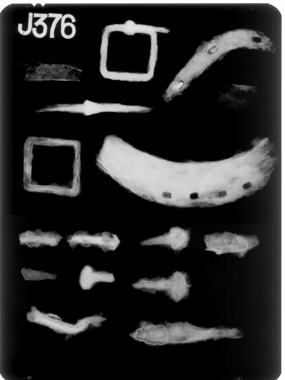
71 71
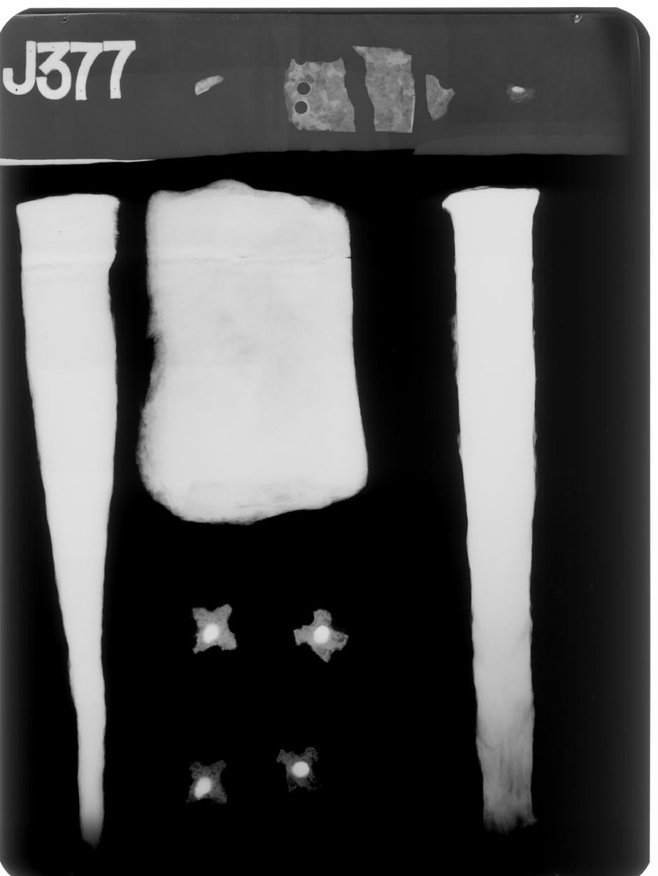
72 72
73 17.2. Assessment of the portable metal finds Quita Mould, freelance finds specialist Methodology This assessment is based on examination of the material and the accompanying X-radiographs. A basic record of the material examined has been made and the catalogue appears as Table appviii.2.1. The information gathered has been correlated with the current contextual information available (Kenney with McKenna 2015) and the finds considered in the light of the specific aims of the project that have been supplied. In addition, it was requested that three copper alloy objects (SF20, 32, and 34) be fully catalogued and they have been fully recorded and discussed in the text below. Condition The material is currently packed in self-sealed polythene bags within air-tight storage boxes containing silica gel. The condition of the metal finds is recorded in the basic record. If a more detailed assessment of condition is required this should be commissioned from an archaeological conservator. Basic quantification and provenance 76 objects from the site were examined and a basic record provided (Table appviii.2.1); they are quantified by material below. Material Count Iron 37 Copper alloy 31 Lead 6 White metal 1 Silver 1 76 The majority of the objects were recovered by metal detecting topsoil/turf in Trench 1 (2013 evaluation trench) and unstratified deposits in Trench 2 (the main excavation) and were clearly 19th or 20th century items principally occurring as a result of casual loss. A small number of metal detected items were datable to the 11-12th century, late medieval or early post medieval periods and are itemised below. 19 objects came from stratified contexts of potentially direct relevance to the interpretation of the site. The principal contexts are: Post holes 2005, 2052, large postholes 2068, 2108 Metalworking pits (pit 2078, shallow hollows 2067 and 2081) Relict plough soil 2054 under inner bank 2116 Slot 17 in inner bank burnt stone deposits 2003 and 2023 (over inner bank 2018) Range and date of the material The stratified material: Dress accessories: Two copper alloy mounts (SF32, 34) and a decorated strap end (SF20) of late medieval date (14 th -early 16 th centuries) are separately catalogued and discussed below (section 6), as requested. A small broken tip from a gilded copper alloy rivet/pin (SF64) came from fill (2080) of a hollow [2081] while a piece broken from a rivet cut from copper alloy sheet (SF18) came from a slot (17) in the inner bank in Trench 1. Two iron stem/rivet fragments (SF103) from a metal mount or possibly pins/needles were recovered from fill (2105) of post void (2106) in post hole [2108]. Knives: A small knife (SF 55) was found in the upper fill of pit [2078] associated with metalworking activity. A fragment broken from the tip of a second example (SF28.2) was found along with a fiddlekey horseshoe nail (SF28.1) in a burnt stone deposit (2003) along with the copper alloy strap end (SF20). Horseshoe nails: Four fiddlekey horseshoe nails of a type used with horseshoes of Clark s Type 2 (Clark 1995) and datable to the 11th-12th centuries were found in stratified deposits: SF28.1 and SF156 were found in a burnt stone deposit (2003) SF 38 upper fill (2072) of post void 2019 in post hole [2005] 73
74 SF39 fill (2071) of post void 2074 in post hole [2052] Timber nails: Two timber nails were recovered from stratified deposits and a broken shank from a third: SF43 from packing deposit (2069) in post hole [2068], SF145 from charcoal rich fill (2099) in the base of pit [2078] associated with metalworking activity, nail shank SF35 from a burnt stone deposit 2023 over bank [2018]. Concreted block: A rectangular block (SF40) weighing 438g with irregular surfaces, including an upstanding flange and a vertical slot or groove in one side, was found in fill (2080) of a shallow hollow [2081], probably a natural feature, thought to have possible relevance to metalworking on the site. Not an iron object, it would appear to be an iron-rich concretion formed in a rectangular sectioned depression. Tim Young (GeoArch) has suggested it may have been formed by accretion of iron-rich deposits in the corner of an organic container (Kenney with McKenna 2015, 8) and this seems a likely explanation for its formation. Bar iron: two small pieces of rectangular strip (SF155.1, 155.2) were found in the slag-rich fill (2066) of an irregular, shallow hollow [2067] adjacent to the feature [2081] containing the concreted block (SF40). Slag and other metal-working debris including remains of a smithing floor and fragments of furnace lining (SF62) were present in the fill [2066] and it is likely that the strip fragments (SF155.1, 155.2) are pieces of bar iron (as defined by Ottaway 1992, 492-3) and also metal-working debris. The unstratified material: The unstratified material comprised principally of coins and small personal items (buckles, buttons, badge, thimble, silver ferrule, modern key, heel irons) of chiefly 19 th and 20 th century date and apparently the result of casual loss. A smaller quantity of household items (furniture knob, window catch, window lead, copper alloy miscellaneous fittings) may suggest that some of the material derives from later occupation in the vicinity or brought in from elsewhere. Other unstratified finds included a mason s pick, tool handle tang, a modern spanner, broken horseshoes and a musket ball. 6 objects found unstratified in Trench 2 can be independently dated to the medieval or early post medieval period, and are listed below: 2 fiddlekey horseshoe nails (11 th -12 th century), 1 cuboid-headed horseshoe nail (14 th -15 th century) Socket possibly broken from a small arrowhead (medieval) Small rotary key and timber nail with faceted head (medieval/early post medieval) Potential for analysis, suggested further work and costing A basic record of the material accompanies this assessment and the majority of the finds will require no further work. It is suggested that the material from stratified deposits be summarised along with relevant independently datable items from unstratified deposits, to inform those writing the site narrative and for inclusion in any published site report as necessary. The detailed description and discussion of the copper alloy objects already selected (see below) will be incorporated into the summary text. Investigative Conservation: Five items have previously undergone conservation (by Phil Parkes Cardiff Conservation Services). One further item would benefit from conservation the complete iron knife SF55 (2077) X-ray J376. The tip of the blade of this knife (SF55) is fractured but held in place within an iron corrosion blister. Conservation would allow it to be more easily illustrated (in consultation with X-radiograph J376). X-radiography: A horseshoe nail (SF63) and two strip fragments (SF155.1, 155.2) were recovered from amongst metal-working debris during post-excavation processing. These items require X-radiography to confirm identification and provide a permanent record. Illustration: It is suggested that the principal objects from stratified deposits be illustrated either by line drawing or good quality photography. copper alloy decorated buckle plate SF20 (2003) copper alloy mounts SF32 (2023) and SF34 (2054) iron knife SF55 (2077) iron fiddlekey horseshoe nail SF28 (2003) Metallurgraphic analysis: The iron rectangular block/concretion (SF40) from shallow hollow [2081] associated with metal working should be considered along with the slag during metallographic analysis of the metalworking debris. 74
75 Detailed description and discussion of selected objects of copper alloy Two small cast copper alloy mounts (SF32 and 34) were found, one (SF32) in a burnt stone deposit (2023) over the inner bank [2018], the other (SF34) in relict ploughsoil (2054) under bank [2116] crossing the SW corner of Trench 2. The mounts are of the same design and construction and are likely to have come from the same item. The mounts were essentially square-headed with decorative scalloped and nicked edges producing a four-armed or cruciform appearance but were heavily worn and the edges of the arms are now broken. They had been used to decorate a leather belt or other personal accessory. A simple folded strap end of copper alloy sheet (SF20) was found in a burnt soil deposit (2003) in Trench 2. Strap ends of folded sheet are a common type being the simplest form to produce, this example (SF20) is relatively wide and has simple incised decoration. Of the examples from the city of London none came from contexts earlier than the late 13 th century (Egan and Pritchard 1991, 129). The impression of woven textile present on both the interior and exterior surface may suggest that the strap end had been attached to a textile girdle rather than a leather strap but the large rivet holes would appear excessive if intended to rivet to anything other than a very coarse material. It may be that the fibres and textile impression are the result of postdepositional proximity to textile. Small decorative mounts such as these were commonly used to decorate a range of personal dress accessories and leather fittings for horses, dogs and hawks in the later medieval period and early post-medieval period across north Western Europe (Egan and Pritchard 1991; Willemsen and Ernst 2012). In general it can be said that small decorative metal mounts were at their most popular in the late 14 th, 15 th and 16 th centuries (Willemsen and Ernst 2012, 14). Detailed catalogue of selected copper alloy finds Copper alloy strap end SF20 Broad strap end of folded sheet 0.5mm thick, folded widthways, one side survives largely intact with a pair of large rivet holes, 3mm in diameter, at the open end and broken across a third. The second side has been broken off close to the fold but a small triangular fragment of it survives. The upper face has crudely incised decoration comprising two triangles infilled with cross hatching; similar decoration is present on the fragment. The impression of woven textile is visible on the inner face and fibres are present on both the outer and inner faces. Incomplete, fractured. Mechanically cleaned and consolidated. Length 30mm, width 23mm. Fragment 13x8mm. SF20, Lab No UWC 6323/02, Trench 2 context Copper alloy mount SF32 Small cast mount with cruciform head and integral round-sectioned rivet. The shank is flat ended. The flat head has four arms each springing from a concave, curving side into a broad, pointed tip flanked by a pair of small projections at the base. None of the four arms are now complete as the edges have been lost through wear. The head has a gently curved profile and is undecorated. Almost complete. Head 13x13mm, shank length 9mm, diameter 3mm. Mechanically cleaned. SF32, Lab No UWC6323/03, Trench 2 context Copper alloy mount SF34 Small cast mount with cruciform head and integral round-sectioned shank, slightly bent over and flattened at the end from hammering. The flat head has a slightly curved profile with concave curving sides with the remains of four arms with paired projections at their base at each corner. Almost complete. Head 13x13mm, 1mm thick. Shank length 8mm. SF34, Lab No UWC 6323/04, Trench 2, context References Clark, J. (ed.) 1995 The Medieval horse and its equipment c c Medieval finds from excavations in London: 5. London: HMSO Egan, G. and F. Pritchard 1991 Dress accessories c c Medieval finds from excavations in London: 3. London: HMSO Kenney J. with R. McKenna 2015 Evaluation of Scheduling Proposals Hen Gastell, Llanwnda. Preliminary Excavation Report. Gwynedd Archaeological Trust Ottaway, P Anglo-Scandinavian Ironwork from Coppergate. The Archaeology of York. The Small Finds 17/6. London: Council for British Archaeology Willemsen, A. and M. Ernst 2012 Medieval Chic in Metal. Decorative mounts on belts and purses from the Low Countries, Zwolle: Spa Uitgevers 75
76 Table appviii.2.1. Basic record of metal objects Context No Find No Material Name Description Condition Completeness Length (mm) width (mm) thickness (mm) diameter (mm) X-ray No Metal detected Lab No Comment Iron buckle frame Copper button alloy Copper alloy Copper alloy Copper alloy Copper alloy Copper alloy Copper alloy Copper alloy Copper alloy Copper alloy Copper alloy Square frame of square section Discoidal button with plain, flat head with no surface decoration visible, broke loop shank broken set into low cone seating encrusted, fissured complete J376 MD post medieval good almost complete 22 MD probably 18th century coin Half penny 1951 George VI good complete MD 20th century fitting T-shaped fitting of sheet c 2mm thick with T-shaped head of dished section with a strap projecting at a right angle with its end pierced by a large central rivet/nail hole good complete head 56, arm 48 head 12, arm 13 2 MD 20th century coin Penny 1935 George V good complete MD 20th century badge discoidal badge with flat round head with traces of yellow and red enamelled surface and recessed border. Integral shank with crescentic head stamped BRAM MEDAL BD Co LTD ALBION BIRMINGHAM good complete 19 MD probably 20th century coin Penny 1948 George VI complete MD 20th century key coin Yale lock key with pierced disc head and stem now bent at a right angle, head stamped UNION made in England comparable size to a Georgian half penny, little surface detail visible, very heavily worn complete 47 (bent) head 24 MD 20th century complete MD probably late 18th/19th century coin Three penny piece 1944 George VI complete MD 20th century coin Penny 1910 Edward VII complete MD 20th century coin Penny 1991 Elizabeth II complete MD 20th century 76
77 Context No Find No Material Name Description Condition Completeness Length (mm) width (mm) thickness (mm) diameter (mm) X-ray No Metal detected Lab No Comment Iron nail, timber fractured timber nail with rectangular sectioned faceted head and rectangular shank with the tip broken Copper alloy Copper alloy encrusted, fissured, fractured almost complete J376 MD late med/post medieval coin Half penny 1920 George IV complete MD 20th century thimble Silver ferrule, collar thimble of thin sheet with machine made indentations, now broken and distorted small collar ferrule of thin sheet from tip of walking cane (remains present within), made in Birmingham Iron pick heavy square-sectioned shank tapering to a rectangular sectioned relatively narrow blade, the flat head is burred. Probably a mason's pick Iron horseshoe right branch of horseshoe broken across the arch with straight-ended flat heel, 4 small rectangular nail holes each 5x4mm, no fuller Iron heel iron left branch of heel iron with planoconvex section tapering slightly to a blunt tip, with 3 rectangular nail holes 2 with shanks in situ Iron buckle square frame of round section with buckle pin (now bent) wrapped around the frame Iron tang, tool round sectioned tang handle, now broken, with a thickened shoulder and beginning of a round sectioned stem Iron sheet c 5 flat sectioned sheet fragments, 2 with a rolled rim, likely to come from a galvanised bucket or similar Copper alloy Copper alloy button button Discoidal button with alpha type loop shank, no surface detail visible on head Discoidal button with edges of head broken in places and cone shank with incomplete height 21+ head 11 MD probably 19th century good complete MD 19th century slightly encrusted, surface flaking encrusted, flaking encrusted, flaking slightly encrusted, surface flaking slightly encrusted, surface flaking complete 175 head 27, shank 20 head 25, shank 20 J377 MD 19th/20th century incomplete J376 MD post medieval incomplete J376 MD post medieval complete 36 5 J376 MD post medieval incomplete 76+ shoulder 11, tang 7 J376 MD post medieval poor incomplete 0.5 rim 8 J376 MD 19th/20th century good complete shank 5 20 MD 19th century good almost complete 30 MD probably 18th century 77
78 Context No Find No Material Name Description Condition Completeness Length (mm) width (mm) thickness (mm) diameter (mm) X-ray No Metal detected Lab No Comment loop missing. Upper face tinned Copper alloy Copper alloy Copper alloy Copper alloy Copper alloy Copper alloy Copper alloy button four hole button with dished centre and flat flange. Flat stamped with raised lettering NOT CUT THREAD LONDON sheet fragment all edges broken with 2 angular nail holes present, 1 with iron corrosion products within knob, furniture window catch cartridge cap sheet, folded fitting Lead window lead junction cast circular knob with recessed head to hold a separate decorative rondel, now missing, concave neck and small circular base with broken iron shank cast window catch with rectangular sectioned, right angled shank with spherical knop terminal with concentric decorative mouldings sheet metal cap with central hole stamped ELEY BROS LONDON small fragment of folded sheet with rolled rim and corrugated profile cast fitting of plano-convex section expanding into a semi-circular straight ended terminal of differing size at each end connected by a short neck. 2 flattened pieces lead, with all edges broken, and a piece of glass 3mm thick sandwiched between. Wt 5g good complete 16 MD 19th/20th century incomplete MD good almost complete 21+ head 26 MD post medieval good complete 59 height 41 MD probably 19th century poor almost complete 21 MD 20th century incomplete 33+ (folded ) 13+ >0.5 MD poor complete MD post medieval incomplete >1 MD post medieval Lead trimming triangular sectioned trimming with slightly curved profile, likely to be cut from a window lead. Wt 4g MD post medieval Lead sheet small fragment of folded sheet Wt 2g incomplete MD White metal spillage thin white metal spillage Wt 1g MD 20th century Copper coin Penny 1916 George V complete MD 20th century alloy Copper coin Penny 1883 Victoria complete MD 19th century 78
79 Context No Find No Material Name Description Condition Completeness Length (mm) width (mm) thickness (mm) diameter (mm) X-ray No Metal detected Lab No Comment alloy Lead musket ball Wt 38g good complete 19 MD post medieval Copper alloy rivet, sheet slightly tapering narrow strip broken at each end and slightly curving in profile, tip of a rivet/shank made sheet metal incomplete J377 UWC 6323/ Lead sheet small piece folded sheet Wt 4g soil adhering incomplete Copper alloy strap end Iron nail, horseshoe Broad strap end of folded sheet, upper face decorated with two opposing incised triangles with cross hatching. Impression of textile on interior, fibres present adhering to exterior fiddlekey horseshoe nail with crescentic head of rectangular section and straight rectangular sectioned shank Iron blade fragment of small blade with triangular section with straight back dropping to the straight edge at a blunt tip, broken before the tang Copper alloy mount cast decorative mount with flat cruciform head and integral round sectioned, flat-ended rivet. Head is gently curved in profile Iron nail, timber rectangular sectioned nail shank with pointed tip Iron nail, horseshoe Copper alloy mount fiddlekey horseshoe nail with crescentic head of rectangular section and curved shank cast decorative mount with flat cruciform head, arms now broken, and integral round sectioned, flat-ended rivet. Head is gently curved in profile Iron bar iron fragment rectangular sectioned strap/strip with straight sides, one end broken, other appears rounded, slightly curved in profile. Found in metalworking debris likely to be conserved incomplete J377 UWC 6323/ 02 encrusted complete 32 head 17 5 J th century encrusted, corrosion blisters incomplete back 4 J376 conserved almost complete head 13 head 13 J377 UWC 6323/ 03 encrusted incomplete 22+ J376 encrusted, flaked at head complete 25 head th century conserved almost complete head 13 encrusted, fissured, flaking complete head 13 J377 UWC 6323/ 04 79
80 Context No Find No Material Name Description Condition Completeness Length (mm) width (mm) thickness (mm) diameter (mm) X-ray No Metal detected Lab No Comment offcut of bar iron Iron bar iron fragment of straight sided strap/strip of rectangular section tapering in thickness at one end which is blunt, other end is straight and slightly burred over. Found in metalworking debris likely to be offcut of bar iron Iron nail, timber clenched shank tapering to a pointed tip iron nail, horseshoe Iron nail, horseshoe fiddlekey horseshoe nail with crescentic head of rectangular section and straight rectangular sectioned shank fiddlekey horseshoe nail with crescentic head of rectangular section and straight rectangular sectioned shank with tip broken Iron knife small knife with centrally placed tang and blade with straight back and edge tapering to a pointed tip Iron concretion rectangular block with straight sides, base has an irregular depression, irregular upper face apparently with a broken upstanding flange around two of the sides and an irregular vertical slot or deep groove in one of the shorter sides. Sooty/charcoal rich deposit on the surface. Probably an iron-rich concretion collected in a rectangular man-made hole. Wt 439g not encrusted Copper alloy rivet shank pointed tip broken from a small shank or rivet of triangular section, other end broken. Gold detected suggesting originally gilded Iron nail, timber small timber nail with flat round head and short shank with the tip now missing encrusted, flaking, corrosion blister present complete encrusted incomplete J376 encrusted complete J th century encrusted almost complete J376 11th-12th century encrusted, corrosion blister complete 73, blade 42 blade 14 back 6 J376 medieval J377 conserved incomplete 7 4 J377 UWC 6323/ 05 encrusted almost complete 21+ head 14 from soil samp le 33 80
81 Context No Find No Material Name Description Condition Completeness Length (mm) width (mm) thickness (mm) diameter (mm) X-ray No Metal detected Lab No Comment Iron stem/rivet 2 fine round sectioned stems each broken at one end and tapering to a pointed end at the other. Broken from needle/pin stems or fine rivets/shanks for metal mounts U/S Tr 2 U/S Tr 2 U/S Tr 2 U/S Tr 2 U/S Tr 2 U/S Tr 2 U/S Tr 2 U/S Tr 2 U/S Tr 2 U/S Tr Copper alloy 23.2 Copper alloy coin button no surface detail visible, of comparable size to a 20th century farthing small discoidal button with gilded head with narrow border, no other surface decoration visible, and alphtype loop shank. Back stamped TREBLE GILT STD COLMS & JD 25.1 Iron spanner spanner with square head of rectangular section with straight, slightly expanded and round ended handle with central tapering tear-drop shaped cut out 25.2 Iron handle round sectioned rod-like handle flattened at one end, now broken, the other end turns at a right angle and is broken across a bifurcated end Iron key small rotary key with remains of broken round bow with simple collar beneath and stem broken across the bit 25.4 Iron nail, horseshoe 25.5 Iron nail, horseshoe 25.6 Iron nail, horseshoe fiddlekey nail with straight shank, tip now missing fiddlekey nail with gently curved shank, tip now missing cuboid headed nail with broken shank 25.7 Iron stem round sectioned stem tapering to a point, other end broken 154 Iron socket?arrowhead small tapering round sectioned socket, potentially from a small arrowhead encrusted incomplete from soil samp le 42 good complete 21 MD post medieval good complete 16 MD 19th/20th century encrusted complete 100 handle 17, head 21x21 encrusted, slightly flaking, corrosion blister encrusted, corrosion encrusted, fissured encrusted, flaking encrusted, fissured encrusted, flaking encrusted, corrosion blister incomplete 107+ stem 9 J375 MD 20th century incomplete 35+ bow 14 J375 MD med/post medieval almost complete J375 MD 11th-12th century almost complete J375 MD 11th-12th century almost complete J375 MD late medieval (14th-15th century) incomplete J375 MD incomplete J375 MD medieval J375 MD 81
82 Context No Find No Material Name Description Condition Completeness Length (mm) width (mm) thickness (mm) diameter (mm) X-ray No Metal detected Lab No Comment U/S Tr 2 U/S Tr 2 U/S Tr 2 U/S Tr 2 U/S Tr 2 U/S Tr 2 U/S Tr 2 U/S Tr 2 U/S Tr Iron heel iron left branch of heel iron with planoconvex section, straight ended with two long rectangular nail holes visible in radiograph Iron nail, timber medium nail with flat round head and square sectioned gently curving broken shank Iron nail, timber medium nail with round flat head and rectangular sectioned curving shank with straight tip Iron nail, timber medium nail with slightly bent rectangular shank broken before the tip and faceted rectangular head flattened from being hit Iron nail, timber nail with round flat head and rectangular sectioned straight shank Iron nail, timber nail with clenched broken shank and small probably rectangular faceted head Iron nail shanks 4 straight nail shank fragments from timber nails ranging from mm in length Iron fragment fragment of thick triangular section, little metal visible in radiograph, no diagnostic features 27 Lead spillage solidified droplet with circular impressed channel in upper surface resulting in a slightly raised disc shaped area. Wt 16g encrusted incomplete J375 MD post medieval encrusted incomplete 112+ head 16 encrusted, flaking slightly encrusted, flaking complete 72 head 17 J375 J375 MD MD almost complete 67+ head 12 head 8 J375 MD encrusted, slightly flaking complete 54 head 12 J375 MD encrusted almost complete 34+ head 10 head 6 J375 MD late med/post medieval encrusted, flaking incomplete J375 MD encrusted incomplete J375 MD MD 82
83 18. APPENDIX IX: Assessment of archaeometallurgical residues Dr T.P. Young, GeoArch: geoarchaeological, archaeometallurgical & geophysical investigations Methods All materials were examined visually with a low-powered binocular microscope where required. As an evaluation, the materials were not subjected to any high-magnification optical inspection, not to any form of instrumental analysis. The identifications of materials in this report are therefore necessarily limited and must be regarded as provisional. The examined materials are listed in Table appix.1. Results Description of residues The submitted materials amounted to an overall total of approximately 7.9kg. The macroscopic collection comprised approximately 900 counted items, with a total weight of 6.1kg, of which approximately 4kg proved to be archaeometallurgical residues in the strict sense (i.e. large after exclusion of concretions and a few pieces of natural rock). Preservation of the residues was generally good. Smithing slags The smithing residues could broadly be divided into two categories smithing hearth cakes (SHCs) and blebby slags containing much partially melted sandy and gravelly sediment. The SHCs were generally well-formed, just slightly concavo-convex, dense slag cakes of small size. Included within this category are smaller slag masses, broadly plano- to concavo- convex, but which are too small to have fully developed the morphology of a typical SHC. These may be interpreted as incipient SHCs, limited in size by the amount of slag generated in the hearth. These have been loosely and informally termed proto-shcs in this account. Taking these and the well-formed SHCs together, there were six reasonably complete examples, weighing 306g, 168g, 104g, 84g, 80g and 72g. The 306g example was a composite cake, including a moderately small SHC attached at its base to an inclined sheet of slag (either an earlier SHC, or perhaps a long-term buildup of slag on the wall/floor of the earth. In addition there was part of a much larger SHC, with a weight of 754g, that might be extrapolated to an original weight in the order of 1kg. This larger cake had a very porous internal structure, with a particularly large void just below the upper surface. The blebby, gravelly, clinkery slags had clearly formed separately from the SHCs, but they too are assigned to the smithing process. Similar slags have been recorded from other sites with low-level hearths on gravelly substrates, both of medieval (e.g. Exminster, Young 2014b) and Roman (e.g. Neath, Young 2013, 2014b) age. Although a small amount of coal was recorded from the site, there was none from the main forge area 9it occurred mainly in isolated pit [2035] and the clinkery appearance of the slags is attributed to the partial melting of a slightly aluminous substrate. The SHCs comprised approximately 49% of the macro-residue assemblage by weight and the clinkery slags 39%. Indeterminate residues There was a variety of slag that was not easily attributable to the classes of slag described above. This indeterminate material comprised approximately 10% of the macroscopic assemblage by weight. Most of the material referred to this class was in the form of fragments too small to be attributed to the other classes, but a small proportion was of small slag blebs and prills. The use of y in Tables appix.2 and appix.3 indicates the presence of indeterminate comminuted slag in the sieved resides samples. Hearth lining There were only a few fragments of hearth lining present (2% of the macro-residue assemblage by weight). The only significant piece was part of a blowhole or tuyère from deposit (2003). This piece showed part of the curving margin of the bore, which suggested a diameter of approximately 35-40mm. The presence of tiny blebs, apparently of slag spatter, on the inside of the bore suggest it was open, but the diameter is unusually large for a 83
84 smithing hearth (more typically the diameter is in the range of 15-30mm) and the possibility that the ceramic was packed around a metal tuyère cannot be discounted. Glazed stone The assemblage included numerous examples of small particles of rock, mainly of gravel grade, that have been glazed by heating in the hearth under the fluxing influence of the fuel ash, but which have not undergone partial melting and incorporation into clinkery slag. Micro-residues The true micro-residues included, dominantly, flake hammerscale, with lesser quantities of spheroidal hammerscale. The coarser micro-residues included examples of slag spheroids, slag blisters and slag flats. Hammerscale is associated with the superficial oxidation of iron at high temperature (Young 2014), with spheroidal hammerscale typically indicative of the process of forge (or fire) welding. Slag spheroids are droplets of smithing slag that cooled within the fuel bed of the hearth, without amalgamating into a large mass. Slag blisters are probably mostly formed as flake hammerscale, but are lifted off the surface of the underlying metal by build-ups of gas. Slag flats are thin skins of slag that, in this case, can be attributed to two distinct origins. Firstly they form as veneers of slag on boulders or cobbles that extend into the hearth pit. This type is characterised by a concave basal fracture. The second type forms by the adherence of slag to either the work piece or to the smith s tools. In the latter case, the presence of slag films with a right angle bend are common having formed in contact with the tips of the smith s tongs or poker. The true micro-residues are accompanied in almost all case by finely comminuted slag debris, derived by the fragmentation of the macroscopic slags. Smithing floor The term smithing floor is applied to concretionary material dominantly or entirely formed by the cementation of fine debris from the smithing process (hammerscale, fine slag fragments and droplets, charcoal ). Most commonly, this material was cemented by the corrosion of small included iron particles, and this appears to be the case with the present material. Although a characteristic material of the floor of a smithy (hence the name), the material may also form in other accumulations of fine-grained smithing debris, such as waste pits. Iron Three iron artefacts were recorded, two fragments of this iron bar and one small nail. Corrosion products from the weathering of iron were also common in the micro-residue collections, but are not always indicated unless certain on the data tables, because of the similarity with iron oxide crusts formed by the weathering of natural rocks. Other The macroscopic collections included, in addition to the material described above, small pieces of coal, concretions formed by iron oxides binding the natural gravel (potentially formed by the weathering of iron objects or debris), and also a number of natural materials. Distribution of residues The distribution of the residues is illustrated in Table appix.2 by context and Table appix.3 sorted by type of feature. Samples from deposits below the bank (layers (2079) and (2082)) produced tiny amounts of hammerscale and fine slag particles. The quantities were very small and the possibility of intrusion of material from later residuerich contexts must be considered, although they may genuinely indicate a degree of pre-bank metalworking. The majority of the residues recovered derived from the cluster of metallurgical features, which bore both the largest assemblages of micro-residues and almost all of the macro-residues. Circular pit [2076] contained a broad spectrum of residues in small quantities, but with a rich hammerscale assemblage. Hollow [2067] produced approximately 70% (2.8kg) of the total true macro-residue from the site (4.0kg). In addition there was over 1kg of smithing floor and 0.9kg of fine-grained metallurgical residues. The upper fills of pit [2078] contained a similar assemblage to that of hollow [2067], but the lower fills lacked macro-residues although they were rich in micro-residues. 84
85 Other pits also yielded residues, with pit [2089] near the southern wall yielding a moderately rich micro-residues assemblage. Pits [2035] and [2056] yielded only trace levels of hammerscale, with pit [2035] also yielding coal and coke. The postholes of the structure produced assemblages of micro-residues and comminuted slag debris from almost all the post-pipe fills and many of the packing fills. The late-stage burnt stone deposits overlying the bank (layer (2003)/(2023)) contained rich hammerscale assemblages accompanied by small quantities of a wide range of macro-residues. Interpretation The nature of both macro- and micro- residues clearly indicates that the metallurgical activity undertaken was ironworking. The small size of the smithing hearth cakes and the abundance of flake hammerscale indicates that the work being undertaken was mostly, if not entirely, associated with the end use of iron in other words blacksmithing. The macroscopic residues were mainly of two kinds a clinkery slag formed of glassy slag binding partially melted sand and gravel in blebby, amorphous masses and denser, typically plano- or concavo- convex masses (SHCs). Several of these masses were so small they could not display the typical form of SHCs, so the term proto-shc has been employed here. These small cakes are interpreted as the early stages of accumulation of a true SHC, and that they would have grown larger given sufficient slag supply. The weight range of the five small SHCs and their incipient equivalents was from 72g to 168g, with a larger piece (306g) being a composite mass of an SHC lying on an earlier denser slag sheet. The exception to these small, dense SHCs, was a partial fragmented SHC weighing 754g (probably originally approximately 1kg). This large SHC had a low density, rather frothy, slag forming much of its upper part. A total assemblage of just seven SHCs does not permit rigorous comparison with SHC assemblages from other sites, but the assemblage is certainly comparable with others from early smithies. With a range of SHC weights of g and a mean weight of approximately 260g for this assemblage, comparative medieval assemblages would include those from: - Exminster, medieval ; SHCs range from g with a mean of 127g.(Young 2014b) - Worcester, Mill Street, 12 th century; SHCs range from g, with a mean of 233g.(Young 2009a) - Worcester, Willow Street, 12 th century; SHCs range from g with a mean of 327g. (Young 2007) - Garryleagh, Co. Cork, 13 th -14 th century; SHCs range from g with a mean of 316g. (Young 2009b) - Coolamurry (Co. Wexford), of 12 th -13 th century date; SHCs range from g with a mean of 386g. (Young 2008) It has been argued (Young 2008b) that in Ireland, the presence of a small proportion of larger SHCs in the assemblages of otherwise small SHCs up until the 13 th /14 th centuries, is due to the need for the smith to undertake some of the final processing of the iron, because iron was traded or moved in an incompletely refined state. The high temperature processing of the iron is a process involving a greater loss of iron, so the slag cakes produced may tend to be larger. That appears, on present evidence, not usually to have been the case in medieval Britain, and fully processed iron may have been the normal form of trade iron. Unusually-sized SHCs that do not fit the main size-frequency distribution for a site, may also indicate another process, such as hearth steel-making. Another factor that may result in the presence of very small SHCs is the potential use of an iron tuyère, instead of a ceramic tuyère or a simple blowhole. The use of an iron tuyère reduces the degree to which the hot-zone impinges on the hearth wall, and therefore reduces the flow of silicate melt into the hearth. The evidence for Hen Gastell was discussed above and it seems likely that a simple clay blowhole was used, but the only surviving blowhole is sufficiently large that it might have held an iron tuyère. The introduction of iron tuyères was progressive, and by the early post-medieval period seems almost universal in England, but ceramic tuyères continued in use well into the post-medieval period in Ireland,. The development of the smithy in this period in Wales is entirely unknown; it is not known whether medieval-style floor level hearths remained in use into the post-medieval period, as it is clear they did, at least locally, in Ireland. 85
86 In summary, the SHCs from Hen Gastell are small, which may reflect one of a number of contributing factors including the tasks undertaken, the nature of the hearth/tuyère and the nature of the iron employed. The hearth technology is certainly compatible with a medieval age, but whether such technology continued in use in N Wales into the post-medieval is not known. The amount of archaeometallurgical waste recovered from the site is relatively low; it is likely that the point(s) of waste disposal from the smithy lay outside the excavated area. This means it is impossible to provide any estimate of the scale or longevity of the activity. None-the-less, the presence of hammerscale in so many of the sampled contexts indicates that a significant quantity must have been distributed across the site. The focus of the activity within the excavated area was the cluster of pits towards the northern side of the structure. Most of the residues (70% of the macro-residues from the site) derive from irregular hollow [2067]. The field description implies this feature had no in-situ burning. This may, therefore, be a worn working hollow, that became filled with debris. Close to this lay circular pit [2076] contained a broad spectrum of residues in small quantities, but with a rich hammerscale assemblage. It is possible this circular pit held a wooden anvil block (into the top of which a small metal anvil could be placed). The unusual iron find SF40 came from a shallow scoop to the north of [2076] and requires further investigation. Furthest east of the features was the probable hearth [2078]. This pit was 0.47 x 0.40m and 0.20m deep. This is unusually small for a medieval forge hearth, but not impossibly so (particularly if the hearth was only intended for the working of small objects). The primary fills of this accumulated on micro-residues, but floor material accumulated in the hearth on its abandonment giving an upper fill somewhat similar to the fill of [2067]. It has been suggested that the red clay within this hearth might be from its superstructure (perhaps particularly a wall between the hearth and the bellows). However, an alternative possibility is that the clay was an attempt to stabilise the pit, for much of the gravelly component observed in the slag may have been derived from the pit sides. The presence of archaeometallurgical residues in the apparently late deposits overlying the bank may indicate late ironworking, but might also indicate movement of waste materials away from the interior of the enclosure long after abandonment of the smithy. Discussion The material is indicative of a blacksmithy undertaking light forge work (evidenced by the small SHCs and by the very small hearth). The residue assemblage is similar to those from other medieval forges where general purpose smithy work appears to have been undertaken. The characteristics of the assemblage are not indicative of date, since late medieval and early post-medieval smithies are almost unknown in Wales. Medieval higher status sites typically yield evidence for at least some working of copper alloy but such evidence is entirely lacking in the present material. The closest comparative assemblages are from a variety of site types, including open rural settings (Exminster, Coolamurry) and an urban setting (Worcester). The scale of the activity cannot be estimated on the basis of the limited material (it is assumed there must have been some off-site dumping of waste), but the permeation of hammerscale into almost all of the adjacent cut features would suggest the activity was not inconsiderable. Further work The assemblage provides a very complete assemblage of macro-and micro-residues produced by what may have been a rather limited set of processes. Some detailed analysis and characterisation of these materials would assist in the understanding of the technology employed, aiding both the interpretation of the site and of similar materials when encountered elsewhere. A programme of analysis is therefore recommended and a costed proposal will be supplied separately. Irrespective of the commissioning of any further work, it is strongly recommended that all the residues are retained for deposition as part of the site archive, as there are so few such assemblages on a national basis. References Young, T.P Evaluation of archaeometallurgical residues from Willow Street and Mill Street, Worcester. GeoArch Report 2007/12. 10pp. 86
87 Young, T.P Archaeometallurgical residues from Coolamurry 7, 04E0323. GeoArch Report 2006/10. 46pp. Young, T.P. 2009a. Evaluation of archaeometallurgical residues from 35 Mill Street, Worcester, GeoArch Report 2009/33, 9 pp. Young, T.P. 2009b. Evaluation of archaeometallurgical residues from the N8 Fermoy-Mitchelstown, Garryleagh, Co. Cork (E2433). GeoArch Report 2009/47. 12pp. Young, T.P Some preliminary observations on hammerscale and its implications for understanding welding. Historical Metallurgy, 45, 1, Young, T.P Assessment of archaeometallurgical residues from Dwr-y-Felin School, Neath (GGAT 677 & 716). GeoArch Report , 31pp. Young, T.P. 2014a. Archaeometallurgical residues from Dwr-y-Felin School, Neath (GGAT 677 & 716). GeoArch Report pp. Young, T.P. 2014b. Assessment of archaeometallurgical residues from Milbury Farm, Exminster, Devon (ACD478). GeoArch Report pp. 87
88 Tables Table appix.1: summary catalogue. Assm = assemblage, FHS = flake hammerscale, SHS = spheroidal hammerscale, SHC = smithing hearth cake Context Find no Sample Label sample Item Item Notes no. wt wt no T2 u/s 26 slag fragment of small SHC, original size not known. Well-formed lower crust with fuel-dimpled base, top largely obscured by concretion cleaning over bank (2018) irregular rounded nubs of black glassy clinkery slag with locally maroon surface and abundant variably melted clasts furnace lining oxidised and slagged lining with blowhole preserved on protrusion. Interior of blowhole is slightly vitrified with fine spatter. Blowhole appears to be 35-40mm diameter Fe slag fragment of irregularly-lobed slag nub with glassy surface, apparently has corroded iron inclusion fine - metalworking 9 assm mainly stone, but some maroon slag, slag spheroids, moderate FHS, some SHS, some fired clay fine - metalworking <1 6 variety of slag types, spheroids, lining, dense, and vesicular fine - metalworking magnet <1 assm small but rich assemblage of FHS, flats, slag fragments, slag spheroid and some stone fine - metalworking magnet <1 assm stone, trace of FHS and SHS, with iron fragment fine - metalworking magnet <1 assm slag fragments and blebs with some FHS in v small assemblage fine - metalworking 2 assm large pieces of lining slag, with trace of FHS amongst finer stones fine - metalworking magnet <1 assm stone, trace of FHS and SHS fine - metalworking magnet 2 assm stone with some FHS and slag - the latter curiously finely crystalline fine - coal <1 5 coal fragments coarse - slag black glassy slag binding variously vitrified, bloated and partially melted lithic clasts fine - metalworking <1 assm stone, trace of FHS and SHS fine - metalworking magnet <1 assm small sample rich in FHS, slag flats and trace of SHS fine - metalworking magnet <1 assm concretion, stone, slag, FHS, slag spheroids, some SHS coarse - slag glassy bound lining slag furnace lining vitrified oxidised fired lining, black glassy vesicular slag. Ceramic has probable leaf impressions Fe slag rusted Fe object - small nail? 88
89 Context Find no Sample Label sample Item Item Notes no. wt wt no dimpled lobate slag nub, possibly part of SHC or incipient SHC, very dense; one end has rusty accretion (probably from iron in slag) blebs of lining slag, pale, glassy cinder? Slag? 4 22 coal and coke fine - coal <1 3 coal fine - metalworking magnet <1 assm stone, trace of FHS and SHS fine - metalworking magnet 3 assm mainly stone, but some FHS and slag flats fine - metalworking magnet <1 assm slag, FHS and SHS fine magnetic material <1 assm stone with trace FHS fine - metalworking magnet <1 assm mainly stone, trace slag and trace FHS coarse metalworking vitrified/glazed gravel debris/slag gravel with adhering slag, in many case glazed also gravel - natural blebby lining influenced slags, mostly with white granule clasts, most maroon surfaced, vitrified slagged lining rough, granular, dense slags dense flowed slag, varying from small good flow slag to more blebby material flats, tool casts etc. only a few show right-angled re-entrants concretionary fragments, mainly rusty, with variably clasts of slag, FHS, charcoal and iron fine metalworking debris (magnet) 524 assm very rich assemblage, dominated by FHS, but with slag flats, slag fragments, slag blebs, slag spheroids, SHS and some concretionary material (lower proportion than in 2099) fine metalworking debris 384 assm assemblage dominated by fine version of maroon, gravel-rich slagged substrate, other material include abundant vesicular to frothy flats, some FS, slag spheroids and prills, vitrified stones,stones attached to slag, concretions and some laminated rusty spalls (unclear if the latter are from rocks or iron) abraded orange ware <1 1 oxidised fired clay 89
90 Context Find no Sample Label sample Item Item Notes no. wt wt no slag 1/ x60x30, small SHC, just slightly concavo-convex, top locally smooth, slightly reddened and with charcoal inclusions, base microdimpled/microprilly, dense x50x25, small proto-shc, prilly base (coated with rusted organics), smooth top with slightly lobate margin double SHC, lower sheet of dense slag, overlain by lining rich SHC, 70x95x60 overall, upper SHC 30mm thick dense stone x65x35, low density SHC, thick gravelly glassy top with stone extending above planar top, lower slag rich in charcoal proto SHC, lobate top with raised centre, strongly prilly base, 60x50x35mm, very gravelly, locally maroon surface block of quartz vein with adhering smithing floor type material - abundant FHS, charcoal and slag x75x40mm, irregular blebby proto-shc, strongly maroon, gravelly, very irregular, upper face was crescentic fragments of very dense cemented smithing floor - rich in FS, slag, charcoal etc iron = 40x20x4mm rounded nubs of low density gravelly lining slag, mostly with slightly maroon surface ferruginous concretions in very coarse gravel some probably associated with iron fragments of gravelly lining slag angular fragment of glass bearing gravel, dense not vesicular fragment from centre of dense concavo-convex SHC with dimpled base and very smooth even top prilly dense slag pieces, probably proto-shc material lip of SHC with extremely porous interior stone fragment slag 2/ small spiky fragments of clinkery lining slag nubs of clinkery lining slag, each low density so possibly coatings on individual clasts 90
91 Context Find no Sample Label sample Item Item Notes no. wt wt no multi-lobed clinkery lining slags, some with inclusions of gravel denser slag lumps, one sheet like, but otherwise these do not resemble SHC fragments rounded strip of iron with turned up end, 45x15x3-4mm with end turned up by c4mm coarse concretions with lots of slag, flats and scale, along with charcoal, straw moulds etc glazed stones natural gravel unusual fired clay with convex iron oxide contact surface one side, one end curves over like blowhole margin - unclear how this could be interpreted as a plug? furnace lining oxidised and slightly slagged ceramic fine slag 1 3 lining slag, one very porous, the other two dense and clinkery fine - metalworking magnet <1 assm mainly stone and FHS, with some slag flats fine magnetic material <1 assm stone with slag, some FHS and SHS fine magnetic material <1 assm stone with trace of slag and FHS metalworking debris 80 <2 1 vitrified/glazed gravel blebby lining influenced slags, mostly with white granule clasts, most maroon surfaced spiky to flowed dense slags flats, tool casts etc concretionary fragments, mainly rusty, with variably clasts of slag, FHS, charcoal and iron (weight includes some dust) <2 8 slag spheroids lining slag with a planar re-entrant face probably picked by tongs/poker fine metalworking debris (magnet) 306 assm assemblage dominated by FHS, with some SHS, also spheroids, slag flats (including re-entrant examples) and other slag debris. Maroon slag and concretions present but in lesser proportion slag fired clay dense clinkery slag nubs, maroon surfaced concretions, at least two probably associated with thin sheet of iron fine metalworking debris 74 assm assemblage dominated by FHS, some larger flats, maroon spheroids, slag 91
92 Context Find no Sample no. Label sample wt Item wt Item no (magnet) fragments, droplets, lining-rich slag blebs metalworking debris 42 assm mainly blebs of clinkery slags, concretions (several lager ones are probably on iron), FHS, slag spheroids, slag fragments, slag flats and blisters slag fragmented large piece of SHC. Bowl filled by vesicular dense slag, base with much adhering gravel (must have formed against sediment not fuel), upper part highly vesicular and frothy, top deeply dimpled with fuel, 115x100v70 fragment, bowl 50mm deep, cannot be more than 80% of original, frothy layer effectively single large void underlies most of the top. top pale and plastic/resinous appearing around fuel dimples irregular mass of glassy gravelly slag, rather dense glass, maroon surface small lining slag fragments fine - metalworking magnet <1 assm stone with trace of slag and SHS fine - metalworking magnet <1 assm stone with trace of slag and FHS porous stone? Slag? porous igneous rock fine magnetic material <1 assm stone with 1 frag of FHS fine - metalworking magnet <1 assm one large piece of lining slag, moderate amount of FHS, some SHS and some fine slag debris, rest stone fine - metalworking magnet <1 assm stone with sparse assemblage of slag, FHS and SHS fine -slag <1 1 bleb of clinkery lining slag fine - metalworking magnet 8 assm dominated by FHS, but lots of maroon slag debris and plenty of SHS and slag spheroids. Some flats and large blisters ceramic 2 7 oxidised fired clay fine metalworking debris 196 assm very rich assemblage of FHS, slag flats, slag spheroids, SHS, maroon slag (magnet) blebs and lots of ashy concretionary material with HS and charcoal mw large slag flats with curved concave attachment areas debris/slag/concretions/iron? maroon slag fragments concretions vitrified pebble <1 1 laminar iron oxides- unclear if spall of rust or from rock fine magnetic material <1 assm. mainly fine stone, one large piece of clinkery lining slag fine - metalworking 4 assm mainly maroon slag, some stone, one carbonised nut (?), fine - metalworking magnet 5 assm mainly stone, some lining slag, moderate FHS, slag spheroid, charcoal Notes 92
93 Context Find no Sample Label sample Item Item Notes no. wt wt no burnt clay <1 1 oxidised fired clay concretion? coarse - slag dark glassy slag binding partially- melted gravel, some charcoal fine - metalworking magnet <1 assm stone with some FHS Table appix.2: summary of residues by context. For the micro-residue assemblages mod = moderate, tr = trace, y = present. context notes macro-residues micro-residues other SHC clinkery slags indet slag hearth lining scale spheroid flats glazed stone smithing floor iron coal conc T2 u/s unstratified cleaning over bank burnt stone deposit 20 y 38 rich y y y 2008 packing fill in p/h [2007] y tr 2012 possible post-pipe fill in p/h [2011] tr 2014 fill of post-pipe in p/h [2009] tr y 2015 fill of post-pipe in p/h [2007] 10 y tr 2023 burnt stone deposit over bank y 14 rich y y fill of pit [2035] tr fill of post-pipe in p/h [2118] tr y 2048 packing fill in p/h [2011] y tr 2053 packing fill in p/h [2052] tr 2056 fill of cut [2055] tr tr 2066 Charcoal and slag rich fill of hollow [2067] rich x 1.10m x 0.15m 2070 fill of post-pipe in p/h [2068] y tr y 2071 fill of post-pipe in p/h [2052] y tr 2072 fill of post-pipe in p/h [2005] y tr 2075 Charcoal rich fill of small pit [2076], 0.60m rich y diameter, 0.30m deep 2079 Buried soil A horizon, under bank 2018 tr 2077 Upper fill of pit [2078] y rich y y 93
94 context notes macro-residues micro-residues other SHC clinkery slags indet slag hearth lining scale spheroid flats glazed stone smithing floor iron coal conc 2082 Layer containing burnt bone and charcoal that tr underlies bank Relatively charcoal rich fill of pit [2089], 0.35 y yes mod x 0.33m, 0.11m deep 2093 packing fill in p/h [2092] y tr 2097 fill of post-pipe in p/h [2092] y 2098 heat reddened clay in the base of pit [2078] y y mod y 2099 Thin, dark, silty charcoal rich fill in the base 2 rich y of pit [2078] 2101 Fill of a possible post void at NW end of posthole [2083] y 2105 Fill of post void [2106] in posthole [2108] 8 y mod y y 2120 Disturbed packing fill of posthole [2119] tr Total weighed Table appix.3: summary of stratified residues by type of feature and context. For the micro-residue assemblages mod = moderate, tr = trace, y = present. Context notes SHC clinkery slags indet slag hearth lining scale spheroids flats glazed stone smithing floor iron Deposits below bank 2079 Buried soil A horizon, under bank 2018 tr 2082 Layer containing burnt bone and charcoal, tr underlies bank 2116 Burnt stone deposits over bank 2003 burnt stone deposit over bank y 38 rich y y y 2023 burnt stone deposit over bank y 14 rich y y 6 Packing fills of postholes 2008 packing fill in p/h [2007] y tr 2048 packing fill in p/h [2011] y tr 2053 packing fill in p/h [2052] tr 2093 packing fill in p/h [2092] y tr 2120 Disturbed packing fill of posthole [2119] tr coal 94
95 Context notes SHC clinkery indet hearth scale spheroids flats glazed smithing iron coal slags slag lining stone floor Post-pipe fills of postholes 2012 possible post-pipe fill in p/h [2011] tr 2014 fill of post-pipe in p/h [2009] y tr y 2015 fill of post-pipe in p/h [2007] 10 tr 2042 fill of post-pipe in p/h [2118] tr y 2070 fill of post-pipe in p/h [2068] y y y 2071 fill of post-pipe in p/h [2052] y y 2072 fill of post-pipe in p/h [2005] tr 2097 fill of post-pipe in p/h [2092] y 2101 Fill of a possible post void at NW end of y posthole [2083] 2105 Fill of post void [2106] in posthole [2108] 8 y mod y Minor pits 2036 fill of pit [2035] y tr fill of cut [2055] tr tr 2090 Relatively charcoal rich fill of pit [2089], 0.35 y y mod x 0.33m, 0.11m deep Metallurgical group 2066 Charcoal and slag rich fill of hollow [2067] rich x 1.10m x 0.15m 2075 Charcoal rich fill of small pit [2076], 0.60m rich y diameter, 0.30m deep 2077 Upper fill of pit [2078] y rich y y 2098 Heat-reddened clay in the base of pit [2078] y y mod y 2099 Thin, dark, silty charcoal rich fill in the base of pit [2078] 2 rich rich
96 19. APPENDIX X: Lithics G. H. Smith, Gwynedd Archaeological Trust Non-flaked stone SF146 Rubbing stone fragment Sub-rounded fragment of very coarse gritstone with predominantly large quartz crystals, rather than a conglomerate. Two faces at approximately 45 to each other have been worn flat with a slight polish. This wear even includes wear of quartz crystals. That could not have happened by any natural wear processes. The broken edges of the object are somewhat rounded rather than angular suggesting that it was broken by burning rather than just shattered. As both faces appear to be flat rather than curving it seems likely to be part of a rubbing stone that has been used on two faces rather than part of a saddle or rotary quern. Gritstone is used for querns and rubbers on Anglesey Iron Age sites, although a conglomerate rock is more common. SF147 Natural piece Concreted quartz-rich fine sand probably from a fossil beach, with preserved marine worm burrow. Not a local material. Similar pieces of material are found off Morfa Conwy when ancient intertidal deposits are exposed so this may have been brought to the site from elsewhere as a curiosity. Flaked stone Measurements in mm along and perpendicular to the striking platform for a flake or max length/breadth/depth for other pieces. () indicates incomplete (broken) dimension. SF14 Flake Yellow-brown pebble flint. Small, thick, secondary, core-trimming flake. Probably punch-struck. 32 x 13 x 7. There is a small area of steep secondary retouch close to the butt and later than the flake itself so is possibly just trample damage. A slight overall gloss suggests the piece has been exposed on the surface for a considerable time in the past. Probably Later Mesolithic or Early Neolithic. SF36 Retouched flake fragment Light grey flint. (17) x (28) x 6. Mid-fragment of a broad flake with shallow secondary retouch on one sharp side edge. Undatable. SF44 Natural piece Light grey flint. Accidentally broken fragment from a natural, angular ice-fractured (glacial) piece. SF53 Utilised blade Mottled light grey/mid-grey flint. 31 x 15 x 4. Thin blade with butt removed by notching and snapping. Utilisation is suggested by unifacial microchipping along one slightly concave sharp side edge. Notch and snap is a Mesolithic technique for production of microlithic points from blades. SF54 Natural piece Mid-grey flint. Small fragment of accidentally broken glacial gravel. SF67 Natural fragments Five natural fragments of shattered and rolled glacial gravel. General Comment SF14, 36 and 53 could be associated and suggest a minor presence of Mesolithic or Neolithic activity here. A briefly used flint knapping or camp site would be appropriate for the location on a knoll overlooking a stream. 96
97 20. APPENDIX XI: Assessment of Post-Medieval Ceramics and Clay Tobacco Pipes Jonathan Goodwin, Stoke-on-Trent Archaeology Service Introduction Stoke-on-Trent Archaeology Service was appointed by Gwynedd Archaeological Trust in April 2015 to undertake the assessment of a small assemblage of post-medieval pottery and clay tobacco pipe fragments recovered from excavations at Hen Gastell, Llanwnda, Gwynedd (SH ). Methodology The small assemblage comprises 28 ceramic vessel sherds and eight clay tobacco pipe fragments. The majority of the finds (c.72%) were recovered from plough-soil layer (2002), supplemented by material from stakehole (004), the fill (2075) of a possible metal-working pit [2076], and an unstratified group. Most of the finds date to the 18 th or 19 th centuries, with a small number of earlier items, one of which (a single sherd from 2002) could be of late-medieval/ early post-medieval date (15 th -16 th century?). The production of a basic catalogue of this material represents an appropriate level of recording. The assemblage is small and largely composed of finds recovered during the cleaning of plough-soil layer (2002). The ceramic catalogue in Table appxi.1 provides details of ware/fabric types, vessel forms, decoration, completeness, quantity (by sherd count) and probable date. A similar methodology was applied to the clay tobacco pipes, which are listed in Table appxi.2. Further analysis of the material is unlikely to yield any further, significant information and, as such, is not considered necessary in this instance. Acknowledgements This report was written by Jonathan Goodwin of Stoke-on-Trent Archaeology Service. Thanks are due to Jane Kenney of Gwynedd Archaeological Trust. References Hemmingway, J Chester Election, The Complete Poll Book. Chester: John Fletcher. Oswald, A Clay Pipes for the Archaeologist. British Archaeological Reports 14. Rutter, J.A Chester s Clay Tobacco Pipes, West Midlands Pottery Research Group Newsletter 7. 97
98 Table appxi.1. Ceramic vessel sherds from Hen Gastell Context Finds no Ware/ fabric description surface dec dec in/on body glzd vessel form/ description Base Body rim/edge spout handle profile no. shds Date Notes coarse e ware y hollow ware * 1 C19 Hard, fine orange/red fabric; iron-rich glaze on interior and exterior (partial) surfaces iron-rich e ware n hollow ware * 1 late medieval? Hard, fine orange fabric; occasional ill-sorted white sub- rounded inclusions; rare burnt-out organic(?) inclusions. slipware trailed slip y hollow ware * 1 late C17- early C18 Brown slip over fine buff fabric; lead glaze. slipware trailed slip y pressmoulded dish * 1 late C17- early C18 Cream and brown slip over fine orange fabric; lead glaze on upper surface. coarse e ware y pan coarse e ware y pan coarse e ware y jar? * * * 1 C18/C19 Hard, fine red fabric; iron-rich glaze on interior and partial exterior. 1 C18/C19 Hard, fine red/orange fabric; patches of ironrich glaze survive on interior and exterior; abraded. 1 C19 Hard, fine red/orange fabric with occasional ill-sorted, sub- rounded white inclusions (clay pellets?); iron-rich glaze on interior and exterior surfaces - possible traces of slip coat beneath. coarse e ware y jar? 1 C18/C19 Hard, fine red/purple fabric with white/cream laminae and occasional, ill-sorted, subrounded white inclusions; one large stone 98
99 Context Finds no Ware/ fabric description surface dec dec in/on body glzd vessel form/ description Base Body rim/edge spout handle profile no. shds Date Notes * inclusion; iron-rich glaze on interior and exterior surfaces (cont.) 56 (cont.) coarse e ware y jar? * 1 C18/C19 Hard, fine red/purple fabric with occasional, ill-sorted, sub- rounded white inclusions; iron- rich glaze on interior and exterior surfaces. coarse e ware y jar? * 1 C18/C19 Hard, fine red fabric with rare, ill-sorted, subrounded white inclusions; iron-rich glaze on exterior surface, slightly reduced on interior. coarse e ware y jar? * 1 C19 Hard, fine red/purple fabric; iron-rich glaze on interior and exterior surfaces. coarse e ware y jar/jug * 1 C19 Hard, fine red/orange fabric; iron-rich glaze on interior and exterior surfaces. coarse e ware y cylindrical mug? * 1 C19 Hard, fine red/orange fabric with rare, illsorted, sub- angular black inclusions (ironore?); iron-rich glaze on interior and exterior surfaces; possible slip coat on exterior at least. coarse e ware y hollow ware 1 C19 Hard, fine red/orange fabric; iron-rich glaze on interior and exterior surfaces. * coarse e ware y small hollow ware bowl? * 1 C19 Hard, fine red/orange fabric; iron-rich glaze on interior and exterior surfaces. coarse e ware y small hollow 1 C19 Hard, fine red fabric; iron-rich glaze on 99
100 Context Finds no Ware/ fabric description 2002 (cont.) 56 (cont.) tin-glazed e ware surface dec dec in/on body glzd vessel form/ description ware Base Body * rim/edge spout handle profile y plate * 1 late C18 creamware? y bowl * 1 early C19 pearlware y plate pearlware UGTP - blue pearlware/ white e ware pearlware/ white e ware UGTP - blue UGTP - blue white e ware UGTP - black pearlware UGP - blue pearlware UGSLD? y y y y y saucer saucer saucer plate cup/bowl turned y cylindrical mug * * * * * * no. shds Date Notes 1 c.1820s/30s 1 1 st half C19 interior and exterior surfaces pitted on exterior. 1 mid C19 Unknown print with coral/seaweed motif. 1 mid C19 Same print and form as above, but probably not part of the same vessel. 1 mid C19 1 early C19 white e ware y jug? * 1 late C19 white e ware y hollow ware * * 1 c.1820s/30s Base/lower body of vessel; possible hint of blue slip within turned band. 1 mid-late C19 bone china UGTP - y cup 1 early-mid Two Temples pattern. 100
101 Context Finds no Ware/ fabric description surface dec dec in/on body glzd vessel form/ description Base Body rim/edge spout handle profile no. shds Date Notes blue C19 * 2002 (cont.) 56 (cont.) porcelaneous fabric? y hollow ware * 1 late C19? Dense, highly fired fabric with tight-fitting glaze on interior and exterior surfaces; somewhat reminiscent of porcelain or china, but is not translucent; exterior glaze is slightly reduced which could indicate an over-fired white e ware blackware y cup 1 late C17- early C18 Hard-fired, fine purple fabric with iron-rich glaze on interior and exterior surfaces. * Total 28 Key: UGTP Under-Glaze Transfer Printed; UGP Under-Glaze Painted; UGSLD Under-Glaze Slip Decorated 101
102 Table appxi.2. Catalogue of clay tobacco pipes from Hen Gastell finds context no. decoration /mark Worn impressed mark comprising a shield with a design of three wheat sheaves and a sword; CHESTER features beneath. u/s 24 Impressed mark AIRES CHESTER * stem bowl * * profile total no. fragments date * 4 C18/C19? * Total 8 notes This design first appears on tobacco pipes produced in Chester during the period (Rutter 1986, 21). 1 late C18/early C19? 1 late C18/early C19? 1 late C18/early C19 The Aires family of pipe makers is recorded in Chester from the mid/late C18 until at least the early C19. Samuel Aires appears in 1767; his son, Thomas, was active between at least 1798 and 1826 (Oswald 1975, 162; Hemingway 1826, 98). A John Aires is also listed in c.1800 (Oswald 1975, 162). 102
103 21. APPENDIX XII: A note on a sherd of medieval pottery A note on a sherd of pottery from Hen Gastell, Llanwnda near Caernarfon - G2246 SF151 from context 2075 Julie Edwards, Chester West and Chester Historic Environment Team A single abraded sherd (2g) of an earthenware with a reduced grey/black core and interior surface and an oxidised red/brown exterior (find no. 151). The exterior is abraded and it is not possible to determine whether the surface was once glazed. The sherd has no distinguishing characteristics that would indicate vessel form. Context (2075) did not produce any evidence, other than the fragment of pottery, which would indicate a deposition date however it is part of a complex of pits related to a forge which radiocarbon analysis dates to cal AD (pers comm Jane Kenney). Discussion The size and condition of this fragment limits any definite identification regarding ware-type, date or provenance. Its condition may also suggest that it is potentially residual to the context in which it was found. There is a lack of evidence for significant pottery use in the medieval period in North Wales before the thirteenth century therefore the association with deposits dated to the 11 th and first part of the 12 th century is potentially significant. The size and condition of the sherd however reduces the level of significance. During the thirteenth and early fourteenth centuries red/grey fired earthenwares were produced at kiln sites in Cheshire and also at Rhuddlan, Denbighshire. They are relatively common finds in Cheshire and North Wales particularly on castle sites where they are linked to the campaigns of the English kings to extend their rule in Wales and the provisioning role of Chester at this time. The fabric of this piece (see description below) is very similar to Fabric 179 in the Cheshire West and Chester Fabric Reference Collection, which is a sample of pottery associated with a dump of pottery production waste found in the Frodsham Street area, to the east of the walled city of Chester ( Rutter 1990). There is also some similarity with the published description of fabric MA2, identified as being from the kiln site at Rhuddlan (Owen 1994, 192). There is not enough evidence to link the sherd with either of these specific production sites and the associated radiocarbon date discounts those sites but the similarity of fabrics suggest that there may be a common clay source which in the Cheshire/North Wales area. A source outside that area cannot be excluded however. It is recommended that the sherd is retained as part of the project archive to enable comparison with any material of contemporary date that may be found in the future. Fabric description Colour: dark brown/black core with black margins, a brownish red exterior surface and a black interior. The fabric is soft with a rough feel and an irregular texture. Inclusions: Moderate ill-sorted fine-medium quartz grains varying in colour from grey to colourless that are largely subangular but with the sparse presence of rounded examples. Sparse very coarse (<2.5 mm) are also present. Moderate-sparse ill-sorted red and black iron-rich inclusions fine to coarse in size (<0.75 mm). Sparse angular - coarse (<1.5 mm) fine grained angular rock fragments black/grey in colour, these are potentially derived from igneous or metamorphic rocks. Sparse coarse (0.75 mm) angular grey fine grained rock (flint/chert?). Sparse coarse (0.5 mm) mica flakes. Surface treatment: slight undulations are apparent on the interior (reduced) surface but it is unclear whether they represent wipe marks or throwing lines. 103
104 References Owen W 1994 Medieval and Post-Medieval pottery (1991). In Quinnell H & Blockley M R with Berridge P 1994 Excavations at Rhuddlan, Clwyd Mesolithic to Medieval. CBA Research Report Rutter J A 1990 Appendix 2 Petrological analysis of thin-sectioned fabrics. In: Ward SW 1990 Excavations at Chester the lesser medieval religious houses, sites investigated Chester City Council Rutter J A 1990 'Arrowcroft Scheme' In: Ward SW 1990 Excavations at Chester the lesser medieval religious houses, sites investigated Chester City Council. 104
105 22. APPENDIX XIII: Burnt stone petrology Dr David Jenkins, freelance geological specialist, formerly of Bangor University The fragmentary rock types within two deposits excavated at Hen Gastell have been examined. Sample 11 (comprising 2 sample buckets) is from context 2023, one of the burnt stone deposits overlying the inner bank, and sample 27 is from context 2070, the fill of post void in posthole [2068]. Information may thereby be obtained about the geographical provenance of the pebbles involved, and also about their selection and utilization: a summary of this analytical data is given in the attached table. Provenance can be in terms of the geological terrain from which the pebbles were derived and of choice of properties for any specific usage that might have been involved. The assemblage of rock types shown in Table 1, however, is seen to be dominated by fine-grained silicic igneous extrusive rocks various rhyolites, some suggesting a glassy early stage, and in associated tuffs grading into sandstones. Such rock types are common in the Palaeozoic strata that form Snowdonia. Dolerites, dark mafic igneous intrusive rocks, are sometimes preferred in fires/furnaces for their thermal properties, but they are only sparsely present in the samples examined, although they are also present in Snowdonia. This suggests that, although limited, the range of pebble types available locally was adequate for requirements which were not apparently demanding. In terms of practical usage, provenance also involves the nature of the source, in this case of rounded to subrounded pebbles. These sources are common locally in the form of the widespread glacial tills and fluvioglacial deposits on the Arfon platform and in more recent derived river and sea-shore gravels. Subsequently, such pebbles have cracked within a fire to give the fragments defined by remnant convex surfaces and the rough cracked fracture surfaces often stained a dark red. More generally, provenance can be revealed by distinctive tracer rock types. Two such tracers may be represented by firstly the angular fragments of a distinctive bright red porphyritic rhyolite found in two of the samples (27 and 11.1), their colour probably deriving from a geological process (such as metasomatism) rather than the darker localized red from a small scale fire. However, the source of this rock material has yet to be identified. Similarly, the rare pebbles of microgranite in one of the samples (11.2) are distinctive and could derive from local intrusions to the south-west. This analysis suggests that the three pebble samples were derived from local sources such as river or beach deposits from the local solid geology. To develop the project any further would require more detailed petrographic analysis of thin sections of the pebbles under a microscope and also field-work to identify specific sources of pebbles. Table: Properties of the three samples: Sample no Context no Weight of samples (kg) Number of stones in sample Size range max (cm) 16x7x6 102x36x4 13x9x6 min (cm) 4x3x1 3x2x1 4x3x1 Shape: rounded (attrition) pebble rounded + fracture surfaces fracture only (planar-conchoidal) surface reddening 50% 45% 68% on the curved/joint distinct/mod/weak - none 9/3/7-8 6/4/5-5 4/4/7-12 on the 19 fractured only distinct/mod/weak - none 8/3/2 23 5/9/ /6/
106 Rock types identified: xx - common; x occasional Sample no Context no Red porphyritic rhyolites * x x - (NB included in counts) Rhyolites and tuffs xx xx xx Microgranites - - x Dolerites x x - Sandstones and tuffs xx xx x Mudstones/phyllites - x x 106
107 23. APPENDIX XIV: Radiocarbon dating Report on Radiocarbon dating and Bayesian modelling Derek Hamilton, Scottish Universities Environmental Research Centre, East Kilbride A total of 14 samples of charred plant material (grain, nut shell, charcoal) were processed for radiocarbon dating from features excavated at the small enclosure site of Hen Gastell, Llanwnda, Wales. The samples were recovered from a range of features that included pits, postholes and post-pipes, and discrete burnt deposits containing large quantities of heat-affected stone. All the samples were short-lived single entities (Ashmore 1999), and were processed and dated at the Scottish Universities Environmental Research Centre, East Kilbride (SUERC). Samples were pretreated, combusted, graphitised, and measured by Accelerator Mass Spectrometry (AMS) as described by Dunbar et al. (2016). The SUERC radiocarbon laboratory maintains rigorous internal quality assurance procedures, and participation in international inter-comparisons (Scott 2003; Scott et al. 2010) indicate no laboratory offsets; thus validating the measurement precision quoted for the radiocarbon ages. The results in Table appxiv.2 are conventional radiocarbon ages (Stuiver and Polach 1977), quoted according to the international standard set at the Trondheim Convention (Stuiver and Kra 1986). The results have been calibrated with the internationally agreed IntCal13 atmospheric curve of Reimer et al. (2013), using OxCal v4.2 (Bronk Ramsey 1995; 1998; 2001; 2009). The date ranges in Table appxiv.2 have been calculated using the maximum intercept method (Stuiver and Reimer 1986), and quoted with the endpoints rounded outward to 10 years. The probability distributions seen in Figure appxiv.1.1 were obtained by the probability method (Stuiver and Reimer 1993). The samples From the evaluation trench (Trench 1) there are four dates from two stratigraphically related contexts. There are two results (SUERC and ) on samples of charred hazel nutshell and willow/poplar charcoal, respectively, that were in a deposit (21) of charred remains mixed into a buried soil. This soil was under the inner bank, and so is indicative of pre-bank activity on the site. The two results are not statistically consistent (T =5.0; ν=1; T (5%)=3.8; Ward and Wilson 1978), suggesting the material is not of a similar age and accumulated over an unknown period of time. The fill (17) of a slot cut into the inner bank returned two results (SUERC and ). These measurements are not statistically consistent (T =7.2; ν=1; T (5%)=3.8; Ward and Wilson 1978). From Trench 2 there is another sequence of radiocarbon dates that bracket the construction of the inner bank. There are two results (SUERC and ) on a fragment of charred hazel nutshell and a charred cereal grain, respectively, from layer (2082) that contained burnt bone and charcoal and runs underneath the inner bank (2116) in this location. This layer (2082) sits above the buried soil (21) that was identified in Trench 1. The two results are statistically consistent (T =0.0; ν=1; T (5%)=3.8; Ward and Wilson 1978), and could be the same actual age. At some point the inner side of bank (2116) was cut and a deposit of burnt stone (2003) was laid down. From this there is a single date (SUERC-64221) on a charred cereal grain. A similar deposit (2023) of burnt stone formed on the inside of the enclosure where a different section of the inner bank (2118) had been truncated. There is a single result (SUERC-64222) on a fragment of charred hazel nutshell from (2023). While the two burnt deposits (2003) and (2023) are not demonstrably coeval, their composition and location suggests that they may be part of the same general activity. The two results are statistically consistent (T =0.1; ν=1; T (5%)=3.8; Ward and Wilson 1978), so that the two samples could be the same actual age. There are four radiocarbon dates, all on single fragments of charred hazel nutshell, from the fills of two postholes located within the interior of the enclosure. In both cases, there is samples from the material used to pack the post and a second sample submitted that was recovered from the fill of the post-pipe. From post-hole [2068], there is a date (SUERC-64226) from the packing deposit (2069) and a date (SUERC-64227) from the fill (2070) of the post-pipe. The two results are statistically consistent (T =0.0; ν=1; T (5%)=3.8; Ward and Wilson 1978) and could be the same actual age. Post-hole [2092] had a date (SUERC-64230) packing deposit (2093) and a date (SUERC-64231) from fill (2097) of the post-pipe [2096]. These two measurements are also statistically consistent (T =0.4; ν=1; T (5%)=3.8; Ward and Wilson 1978). There are a final two dates from the base of pit [2078]. The first result (SUERC-64232) is on a fragment of charred hazel nutshell that was embedded in a lump of fire-reddened clay (2098). This was lying on the base of the pit, on a thin charcoal-rich deposit (2099) from which a charred cereal grain was also dated (SUERC- 107
108 64236). The two results are statistically consistent (T =0.0; ν=1; T (5%)=3.8; Ward and Wilson 1978) and could be the same actual age. It is interesting to note that all the results are not statistically consistent (T =27.6; ν=13; T (5%)=22.4; Ward and Wilson 1978). Even after removal of the four results from the pre-bank deposits, the remaining results are not statistically consistent (T =18.9; ν=9; T (5%)=16.9; Ward and Wilson 1978). This suggests that while there is a high degree of internal consistency within the pit, post-holes and the post-bank burnt deposit, the radiocarbon results do not reflect a single event, but rather activity over a protracted period. The model The initial Bayesian model for the results adhered to the observed field stratigraphy and supposed chronological relationships, based on taphonomic understanding of the contexts. For the deposits related directly to the inner ditch, they are placed into two groups: pre- and post-bank deposits. Therefore (21) and (2082) are earlier than (17), (2003), and (2023). Furthermore, the model calculates the probability of an event between the two sets of deposits to provide a date estimate for when the bank was constructed. For the two post-holes, the dates of the material in the packing deposit should date to when the post was put into the ground or before, while the material in the post-pipe should date activity that occurred around the post, with the material falling into voids around the post as it decayed (Reynolds 1995). Therefore, the material from the post-packing should pre-date the material from the post-pipe, and this is reflected in the model as well. While the clay lump on the base of pit [2078] is stratigraphically later than the deposit on the base, the two may very well actually be part of the same event and have been left as an unordered pair in the model. The results This model has good agreement between the radiocarbon dates and the archaeology (Amodel=61). The model estimates that the dated activity at Hen Gastell began in cal AD (95% probability; Fig. 1; start: Hen Gastell), and probably in either cal AD (38% probability) or cal AD (30% probability). The inner bank was constructed in cal AD (95% probability; Fig. 1; build: Inner Bank), and probably in either cal AD (6% probability) or cal AD (63% probability). Activity on the site ended in either cal AD (18% probability; Fig. 1; end: Hen Gastell) or cal AD (18% probability; Fig. 1; end: Hen Gastell) or cal AD (77% probability), and probably in either cal AD (68% probability). The overall span of dated activity is years (95% probability; Fig. 2; span: Hen Gastell), and probably years (68% probability). Sensitivity analysis An alternative model was constructed to test the sensitivity of the modelled data to the inclusion of the sequencing of the post-hole dates. That model has poor agreement between the radiocarbon dates and model assumptions (Amodel=54). This suggests that ordering of the samples, as inferred from the archaeology, is critical to the production of a robust chronological model. Discussion The chi-square tests between pairs of dates show that the results on paired samples from many of the features are statistically consistent, indicating the measurements could be the same age. This suggests the material is likely to be closely related in date. However, because the overall chi-squares for measurements on all the samples, and just those that do not clearly pre-date the inner bank construction, are not statistically consistent, it is likely that the activity within the enclosure was not necessarily short lived. The modelling suggests that it perhaps covered a period of three or four generations sometime in the 11 th and 12 th centuries cal AD. Works Cited Ashmore, P.J., Radiocarbon dating: avoiding errors by avoiding mixed samples, Antiquity 73, Bronk Ramsey, C., Radiocarbon calibration and analysis of stratigraphy: the OxCal program, Radiocarbon 37, Bronk Ramsey, C., Probability and dating, Radiocarbon 40, Bronk Ramsey, C., Development of the radiocarbon calibration program, Radiocarbon 43, Bronk Ramsey, C., Bayesian analysis of radiocarbon dates, Radiocarbon 51, Bronk Ramsey, C., Higham, T.F.G., Leach, P., Towards high-precision AMS: progress and limitations, Radiocarbon 46, Bronk Ramsey, C., Hedges, R.E.M., Use of the CO 2 source in radiocarbon dating by AMS, Radiocarbon 31, Buck, C.E., Cavanagh, W.G., Litton, C.D., Bayesian approach to interpreting archaeological data, John Wiley & Sons, Ltd., Chichester. 108
109 Dunbar, E., Cook, G.T., Naysmith, P., Tripney, B.G., Xu, S., AMS 14 C dating at the Scottish Universities Environmental Research Centre (SUERC) Radiocarbon Dating Laboratory, Radiocarbon 58(1) Reimer, P.J., Bard, E., Bayliss, A., Beck, J.W., Blackwell, P.G., Bronk Ramsey, C., Buck, C.E., Cheng, H., Edwards, R.L., Friedrich, M., Grootes, P.M., Guilderson, T.P., Haflidason, H., Hajdas, I., Hatté, C., Heaton, T.J., Hoffmann, D.L., Hogg, A.G., Hughen, K.A., Kaiser, K.F., Kromer, B., Manning, S.W., Niu, M., Reimer, R.W., Richards, D.A., Scott, E.M., Southon, J.R., Staff, R.A., Turney, C.S.M., van der Plicht, J., IntCal13 and Marine13 radiocarbon age calibration curves 0 50,000 years cal BP, Radiocarbon 55, Reynolds, P.J., The life and death of a post-hole, Interpreting Stratigraphy 5, Scott, E.M., The Third International Radiocarbon Intercomparison (TIRI) and the Fourth International Radiocarbon Intercomparison (FIRI) : results, analysis, and conclusions, Radiocarbon 45, Scott, E.M., Cook, G.T., Naysmith, P., A report on phase 2 of the Fifth International Radiocarbon Intercomparison (VIRI), Radiocarbon 52. Stuiver, M., Kra, R.S., Editorial comment, Radiocarbon 28, ii. Stuiver, M., Polach, H.A., Reporting of 14 C data, Radiocarbon 19, Stuiver, M., Reimer, P.J., A computer program for radiocarbon age calibration, Radiocarbon 28, Stuiver, M., Reimer, P.J., Extended 14 C data base and revised CALIB C calibration program, Radiocarbon 35,
110 Figures Figure appxiv.1.1: Chronological model for the dated activity associated with the enclosure at Hen Gastell, Llanwnda. Each distribution represents the relative probability that an event occurred at some particular time. For each of the radiocarbon measurements two distributions have been plotted, one in outline which is the result of simple radiocarbon calibration, and a solid one which is based on the chronological model use. The other distributions correspond to aspects if the model. For example, start: Hen Gastell is the estimated date that the activity began at the site. The large square brackets down the left-hand side along with the OxCal keywords define the overall model exactly. 110
111 Figure appxiv.1.2: Probability distribution for the number of years over which activity at the Hen Gastell took place. The probability is derived from the model defined in Figure appxiv
112 23.2. Table appxiv.2: Table of radiocarbon dates from Hen Gastell Lab ID Context description Material δ 13 C ( ) Radiocarbon age (BP) Calibrated date (95% confidence) SUERC Fill (17) of slot in the inner bank in Trench 1. Contained burnt stone deposits charred hazel nutshell ±30 cal AD SUERC SUERC SUERC Context (17). Same context as SUERC Buried soil (21) under the inner bank in Trench 1. Charred remains are mixed into the buried soil here and represent prebank activity. Context (21). Same context as SUERC SUERC Burnt layer (2003) with an abundance of angular and heat-fractured stone SUERC Burnt stone layer (2023) over bank Contained charcoal and heat-fractured stones. SUERC Packing deposit (2069) in posthole [2068] SUERC Deposit (2070) filling the post-pipe in posthole [2068]. The deposit contained a high proportion of burnt stone. SUERC Layer (2082) of burnt bone and charcoal underlying bank SUERC Layer (2082) of burnt bone and charcoal underlying bank 2116 and above the buried pre-bank soil. SUERC Packing deposit (2093) in posthole [2092] with some burnt and heataffected stones. SUERC Fill (2097) of post void [2096] in posthole [2092]. SUERC Lump (2098) of heat reddened clay in the base of pit [2078]. Possibly part of the lining of a collapsed superstructure. SUERC Thin charcoal-rich fill (2099) in the base of pit [2078] charred cereal grain: Avena sp. charred hazel nutshell charcoal: Salix/Populus sp.) charred grain: indeterminate charred hazel nutshell charred hazel nutshell charred hazel nutshell charred hazel nutshell charred cereal grain: indeterminate charred hazel nutshell charred hazel nutshell charred hazel nutshell charred cereal grain: indeterminate ±30 cal AD ±30 cal AD ±30 cal AD ±29 cal AD ±29 cal AD ±29 cal AD ±27 cal AD ±29 cal AD ±29 cal AD ±29 cal AD ±29 cal AD ±27 cal AD ±29 cal AD
113 23.3. Radiocarbon Certificates 113
114 114
115 115
116 116
117 117
118 118
119 119
120 120
121 121
122 122
123 123
124 124
125 125
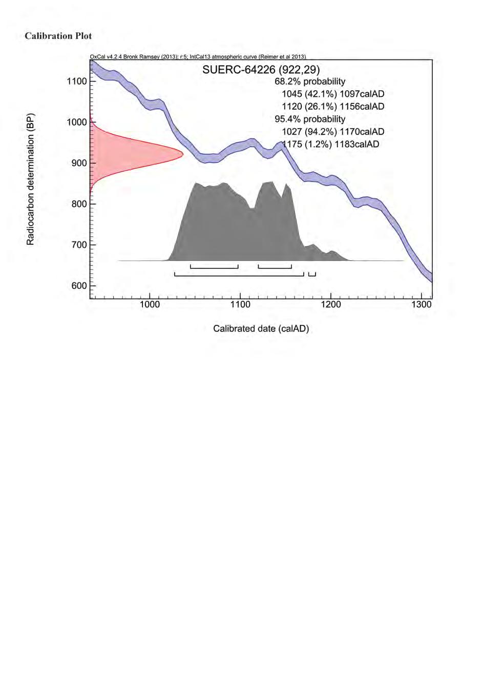
126 126
127 127
128 128
129 129
130 130
131 131
132 132
133 133
134 134
135 135
136 136
137 137
138 138
139 139
140 140
141 24. FIGURES AND PLATES Figures Figure 1. Location of Hen Gastell and nearby sites Figure 2. Hen Gastell showing topography and location of trenches Figure 3. Outline plan of features within trench 2, also showing trench 1 Figure 4. Plan of trench 2 showing burnt stone deposits and detail of post-pipes and packing stones Figure 5. Plan of trench 2 showing banks exposed and other features fully excavated Figure 6. Sections of postholes Figure 7. Sections of postholes Figure 8. Sections of pits Figure 9. North facing section through bank (2116) and burnt stone layer (2003) Figure 10. East facing section through banks (2116) and (2018) and burnt stone layers (2003) and (2023) Figure 11. South-west facing section through bank (2018) and burnt stone layer (2023) Figure 12. Finds. Copper alloy: SF20 - strap end, SF32 and 34 - decorative mounts. Iron: SF55 - knife, SF154 possible arrowhead socket, SF fiddle-key horseshoe nail, SF knife blade. Pottery - SF151 - small medieval pot sherd (all at a scale of 2:1) Figure 13. Distribution of metal-working debris across trench 2 Figure 14. Distribution of bone across trench 2 Figure 15. Distribution of charcoal by species across trenches 1 and 2 Figure 16. Distribution of total quantities of charcoal across trenches 1 and 2 Figure 17. Distribution of charred hazelnut shells and cereal grains across trenches 1 and 2 (sample 29 from smithing pits excluded. This contains 3381 cereal grains and fragments of chaff) Figure 18. Excavated features related to earthworks with possible interpretations Figure 19. Grey scale geophysics plot with excavated features overlaid Figure 20. Plan of house VII, Mirville (Figure 8.23b, from Higham, R. and Barker, P., Timber Castles, University of Exeter Press, Exeter, 264) Figure 21. Plan of the summit of the motte at Castlehill of Strachan (Illus. 3, from Yeoman, P. A., Excavations at Castlehill of Strachan, , Proc Soc Antiq Scot, 114, ) Plates Plate 1. View of 3D model: Hen Gastell from the west Plate 2. Site under excavation from the air (copyright Alan K Hole) Plates 3 to 5. Volunteers cleaning, excavating and recording on site Plate 6. School children excavating in trench 3 Plate 7. Inside the marquee at the Open Day Plate 8. Site tours were given in Welsh and English on a wet Open Day Plate 9. Arc of postholes marked by white arrows Plate 10. Posthole [2122] fully excavated Plate 11. Posthole [2068] half sectioned showing burnt stone in post-pipe Plate 12. Posthole [2108] half sectioned showing burnt stone in post-pipe Plate 13. Post-pipe and packing stones in posthole [2005] Plate 14. Stone blocking top of post-pipe [2096] in posthole [2092] Plate 15. Posthole [2102] and beam slot [2104] Plate 16. Pits [2076], [2078] and [2081] fully excavated Plate 17. Hollow [2067] half sectioned Plate 18. Iron object SF40 from pit [2081] Plate 19. Smithing hearth pit [2078] half sectioned, showing clay in the base of the pit Plate 20. Pit [2113] in baulk section Plate 21. Area of burnt natural [2115] Plate 22. Ice wedge [2124], continuing under baulk Plate 23. NE facing section through bank 2116 Plate 24. Section of bank (2018) Plate 25. Section of bank (2116) with burnt stone deposit (2003) built up against inner side Plate 26. Copper alloy decorative mount (SF32), before conservation (cm scale) 141


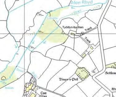
142 46 Crown copyright. All rights reserved. License number AL Gadlys Dinas y Prif Hen Gastell site 57 SH Figure 1. Location of Hen Gastell and nearby sites 57
143 Key 4715 Crown Copyright and database right Ordnance Survey Welsh Government Hawlfraint a hawliau cronfa ddata r Goron Rhif Trwydded yr Arolwg Ordnans Trench excavated 2013 Trenches excavated 2014 Walls/cloddiau Blocked entrances through walls Fences Roofed buildings River Manure heap N A T T1 T2 new extension 5735 gate garden old farmhouse Hen Gastell Farm 5735 barn old orchard Afon Carrog SH 0 50m 5730 Figure 2. Hen Gastell showing topography and location of trenches
144 Key Posthole Postpipe Ditch edge Large stone Burnt stone deposit Metal-working pit semi-subterranean building Area of reddened natural Natural hollows Trench Other archaeological features Natural deposits with context no bank N 0 5m Trench bank SH Figure 3. Outline plan of features within trench 2, also showing trench 1
145 Key Cut feature 013 Postpipe Unburnt stones Fig 11 Burnt stones Burnt stone deposit Area of reddened natural 2024 Natural features N 2094 Division in general natural deposits with context numbers Location of sections on figures 6-8 Top of trench edge Base of trench edge bank 2018 Fig Fig 9 0 5m SH bank Figure 4. Plan of trench 2 showing burnt stone deposits and detail of post-pipes and packing stones
146 Key Cut feature Unburnt stones 015 Area of reddened natural Natural features Division in general natural deposits with context numbers Top of trench edge Base of trench edge Sondages within features N bank m 2057 SH 2047 Figure 5. Plan of trench 2 showing banks exposed and other features fully excavated bank
147 58.88m OD NW 2019 SE 58.84m OD SE NW Posthole [2005] Posthole [2007] ENE WSW 58.81m OD 2025 SE 58.95m OD NW Posthole [2009] # # # # Posthole [2011] 0 1m 58.89m OD SW NE 58.50m OD N S Posthole [2068] Posthole [2052] m OD NE SW Key Posthole [2087] 2087 Burnt stones Unburnt stones # # # Charcoal 0 1m SSW NNE 58.71m OD ENE WSW 58.64m OD 2083 Posthole [2083] Posthole [2092] Figure 6. Sections of postholes
148 NW SE 59.18m OD Beam slot [2104] m SW NE 59.14m OD m OD Posthole [2108] and pit [2113] SW NE 61.03m OD WSW ENE 58.70m OD Posthole [2119] Posthole [2118] 0 1m Key Burnt stones NNE SSW Unburnt stones 58.58m OD # # # Charcoal Posthole [2122] Figure 7. Sections of postholes
149 SE NW E W 59.00m OD 58.79m OD Pit [2035] Pit [2049] m 58.92m OD NNW pale lens SSE # # # # # # # # # # 2066 # # # # # # # # # # # # 2067 Smithy hollow [2067] 0 1m 58.91m OD SE 40 NW # # # # # # # # # # # # # # # # 2075 # # 2076 # # # # Possible anvil foundation [2076] 2081 Key Burnt stones Unburnt stones # # # Charcoal Pot sherd 58.94m OD SSE NNW Iron object Heat reddened clay Find number Smithing hearth base [2078] Figure 8. Sections of pits
150 E W m OD m OD m Figure 9. North facing section through bank (2116) and burnt stone layer (2003) S N 58.78m OD m OD m Key Burnt stones Figure 10. East facing section through banks (2116) and (2018) and burnt stone layers (2003) and (2023) Unburnt stones Limit of excavation NW SE m OD m OD m Figure 11. South-west facing section through bank (2018) and burnt stone layer (2023) Figures 4 and 5


151 SF mm SF 34 SF 32 SF 55 SF 154 SF 28.1 SF mm SF 151 Figure 12. Finds. Copper alloy: SF20 - strap end, SF32 and 34 - decorative mounts. Iron: SF55 - knife, SF154 - possible arrowhead socket, SF fiddle-key horseshoe nail, SF knife blade. Pottery - SF151 - small medieval pot sherd (all at a scale of 2:1)
152 Figure 13. Distribution of metal-working debris across trench Total weight of metal-working debris (g) Buried soil Burnt stone Metal-working Smithing Pits Ploughsoil Post packing Post-pipe Pre-bank layer US pits Feature type Figure 14. Distribution of bone across trench Total weight of bone (g) Bank Buried soil Burnt stone Metal-working Smithing Pits Ploughsoil Post packing Post-pipe Pre-bank layer pits Feature type
153 Key 500 Oak Hazel Willow/poplar Ash Alder Number of fragments Buried soil Burnt stone Burnt stone in post-pipes Smithing Metal-working Pits Pit Post packing Post-pipe Pre-bank layer pits Feature types Figure 15. Distribution of charcoal by species across trenches 1 and 2
154 Number of fragments Burnt stone Buried soil Burnt stone Burnt stone post-pipe Metal-working Smithing Pits Post packing Post-pipe Pre-bank layer in post-pipes pits Feature types Figure 16. Distribution of total quantities of charcoal across trenches 1 and 2
155 350 Key Hazelnut shells 300 Charred cereal grains 250 Number of items Buried soil Burnt stone Burnt stone in post-pipes Smithing Metal-working pits Pits Post packing Post-pipe pre-bank layer Feature type Figure 17. Distribution of charred hazelnut shells and cereal grains across trenches 1 and 2 (sample 29 from smithing pits excluded. This contains 3381 cereal grains and fragments of chaff.)
156 5740 Key Trench excavated Crown Copyright and database right Ordnance Survey Welsh Government. Hawlfraint a hawliau cronfa ddata r Goron Rhif Trwydded yr Arolwg Ordnans Trenchs excavated 2014 Walls/cloddiau Blocked entrances through walls Fences Roofed buildings Excavated features Posthole Burnt stone deposit Metal-working pit Area of reddened natural Excavated ditch Cut for possible building Interpretation Possible circular structure Possible rectangular stucture new extension 0 10m old farmhouse 5735 SH gate 5735 garden Figure 18. Excavated features related to earthworks with possible interpretations Figure Hen G


157 Key Trench excavated 2013 Trench excavated 2014 Posthole Burnt feature Possible circular structure Possible rectangular stucture Strong black and white signals are ferrous dipoles caused by iron objects in the soil 0 10m Figure 19. Grey scale geophysics plot with excavated features overlaid

158 Figure 20. Plan of house VII, Mirville (Figure 8.23b, from Higham, R. and Barker, P., Timber Castles, University of Exeter Press, Exeter, 264) Figure 21. Plan of the summit of the motte at Castlehill of Strachan (Illus. 3, from Yeoman, P. A., Excavations at Castlehill of Strachan, , Proc Soc Antiq Scot, 114, )


159 Plate 1. View of 3D model: Hen Gastell from the west Plate 2. Site under excavation from the air (copyright Alan K Hole)


160 Plates 3 to 5. Volunteers cleaning, excavating and recording on site


161 Plate 6. School children excavating in trench 3 Plate 7. Inside the marquee at the Open Day Plate 8. Site tours were given in Welsh and English on a wet Open Day


162 Plate 9. Arc of postholes marked by white arrows Plate 10. Posthole [2122] fully excavated Plate 11. Posthole [2068] half sectioned showing burnt stone in post-pipe


163 Plate 12. Posthole [2108] half sectioned showing burnt stone in post-pipe Plate 13. Post-pipe and packing stones in posthole [2005] Plate 14. Stone blocking top of post-pipe [2096] in posthole [2092]

![beam slot [2104] Plate](/docs-images/96/127297365/images/164-1.jpg "16. Pits [2076], [2078]")
![and [2081] fully](/docs-images/96/127297365/images/164-2.jpg "excavated Plate 17.")
164 Plate 15. Posthole [2102] and beam slot [2104] Plate 16. Pits [2076], [2078] and [2081] fully excavated Plate 17. Hollow [2067] half sectioned

![SF40 from pit [2081] Plate 19.](/docs-images/96/127297365/images/165-1.jpg "Smithing hearth pit [2078]")

165 Plate 18. Iron-rich concretion object SF40 from pit [2081] Plate 19. Smithing hearth pit [2078] half sectioned, showing clay in the base of the pit Plate 20. Pit [2113] in baulk section

![[2115] Plate 22.](/docs-images/96/127297365/images/166-1.jpg "Ice wedge [2124],")

166 Plate 21. Area of burnt natural [2115] Plate 22. Ice wedge [2124], continuing under baulk Plate 23. NE facing section through bank 2116
 Plate 25.")
 built up")

167 Plate 24. Section of bank (2018) Plate 25. Section of bank (2116) with burnt stone deposit (2003) built up against inner side Plate 26. Copper alloy decorative mount (SF32), before conservation (cm scale)

168 Gwynedd Archaeological Trust Ymddiriedolaeth Archaeolegol Gwynedd Craig Beuno, Ffordd y Garth, Bangor, Gwynedd. LL57 2RT Ffon: Ffacs: gat@heneb.co.uk
Hen Gastell, Llanwnda A Medieval Defended Site
 Hen Gastell, Llanwnda A Medieval Defended Site Summary of Excavation Report Ymddiriedolaeth Archaeolegol Gwynedd Gwynedd Archaeological Trust 47 46 48 Crown Copyright and database right 2016. Ordnance
ARCHAEOLOGICAL EVALUATION AT BRIGHTON POLYTECHNIC, NORTH FIELD SITE, VARLEY HALLS, COLDEAN LANE, BRIGHTON. by Ian Greig MA AIFA.
 ARCHAEOLOGICAL EVALUATION AT BRIGHTON POLYTECHNIC, NORTH FIELD SITE, VARLEY HALLS, COLDEAN LANE, BRIGHTON by Ian Greig MA AIFA May 1992 South Eastern Archaeological Services Field Archaeology Unit White
39, Walnut Tree Lane, Sudbury (SUY 073) Planning Application No. B/04/02019/FUL Archaeological Monitoring Report No. 2005/112 OASIS ID no.
 Planning Application No. B/04/02019/FUL Archaeological Monitoring Report No. 2005/112 OASIS ID no.") 39, Walnut Tree Lane, Sudbury (SUY 073) Planning Application No. B/04/02019/FUL Archaeological Monitoring Report No. 2005/112 OASIS ID no. 9273 Summary Sudbury, 39, Walnut Tree Lane, Sudbury (TL/869412;
39, Walnut Tree Lane, Sudbury (SUY 073) Planning Application No. B/04/02019/FUL Archaeological Monitoring Report No. 2005/112 OASIS ID no. 9273 Summary Sudbury, 39, Walnut Tree Lane, Sudbury (TL/869412;
An archaeological evaluation at the Lexden Wood Golf Club (Westhouse Farm), Lexden, Colchester, Essex
, Lexden, Colchester, Essex") An archaeological evaluation at the Lexden Wood Golf Club (Westhouse Farm), Lexden, Colchester, Essex January 2000 Archive report on behalf of Lexden Wood Golf Club Colchester Archaeological Trust 12 Lexden
An archaeological evaluation at the Lexden Wood Golf Club (Westhouse Farm), Lexden, Colchester, Essex January 2000 Archive report on behalf of Lexden Wood Golf Club Colchester Archaeological Trust 12 Lexden
New Composting Centre, Ashgrove Farm, Ardley, Oxfordshire
 New Composting Centre, Ashgrove Farm, Ardley, Oxfordshire An Archaeological Watching Brief For Agrivert Limited by Andrew Weale Thames Valley Archaeological Services Ltd Site Code AFA 09/20 August 2009
TAI COCHION AND TREFARTHEN ROMAN SETTLEMENT
 1037 TAI COCHION AND TREFARTHEN ROMAN SETTLEMENT Interim Excavation Report Ymddiriedolaeth Archaeolegol Gwynedd Gwynedd Archaeological Trust TAI COCHION AND TREFARTHEN ROMAN SETTLEMENT Interim Excavation
An archaeological evaluation at 16 Seaview Road, Brightlingsea, Essex February 2004
 An archaeological evaluation at 16 Seaview Road, Brightlingsea, Essex February 2004 report prepared by Kate Orr on behalf of Highfield Homes NGR: TM 086 174 (c) CAT project ref.: 04/2b ECC HAMP group site
Moray Archaeology For All Project
 School children learning how to identify finds. (Above) A flint tool found at Clarkly Hill. Copyright: Leanne Demay Moray Archaeology For All Project ational Museums Scotland have been excavating in Moray
3. The new face of Bronze Age pottery Jacinta Kiely and Bruce Sutton
 3. The new face of Bronze Age pottery Jacinta Kiely and Bruce Sutton Illus. 1 Location map of Early Bronze Age site at Mitchelstown, Co. Cork (based on the Ordnance Survey Ireland map) A previously unknown
7. Prehistoric features and an early medieval enclosure at Coonagh West, Co. Limerick Kate Taylor
 7. Prehistoric features and an early medieval enclosure at Coonagh West, Co. Limerick Kate Taylor Illus. 1 Location of the site in Coonagh West, Co. Limerick (based on the Ordnance Survey Ireland map)
Colchester Archaeological Trust Ltd. A Fieldwalking Survey at Birch, Colchester for ARC Southern Ltd
 Colchester Archaeological Trust Ltd A Fieldwalking Survey at Birch, Colchester for ARC Southern Ltd November 1997 CONTENTS page Summary... 1 Background... 1 Methods... 1 Retrieval Policy... 2 Conditions...
Church of St Peter and St Paul, Great Missenden, Buckinghamshire
 Church of St Peter and St Paul, Great Missenden, Buckinghamshire An Archaeological Watching Brief for the Parish of Great Missenden by Andrew Taylor Thames Valley Archaeological Services Ltd Site Code
An archaeological watching brief and recording at Brightlingsea Quarry, Moverons Lane, Brightlingsea, Essex October 2003
 An archaeological watching brief and recording at Brightlingsea Quarry, Moverons Lane, Brightlingsea, Essex commissioned by Mineral Services Ltd on behalf of Alresford Sand & Ballast Co Ltd report prepared
Test-Pit 3: 31 Park Street (SK )
") -Pit 3: 31 Park Street (SK 40732 03178) -Pit 3 was excavated in a flower bed in the rear garden of 31 Park Street, on the northern side of the street and west of an alleyway leading to St Peter s Church,
-Pit 3: 31 Park Street (SK 40732 03178) -Pit 3 was excavated in a flower bed in the rear garden of 31 Park Street, on the northern side of the street and west of an alleyway leading to St Peter s Church,
An archaeological watching brief at Sheepen, Colchester, Essex November-December 2003
 An archaeological watching brief at Sheepen, Colchester, Essex November-December 2003 report prepared by Ben Holloway on behalf of Colchester Borough Council CAT project ref.: 03/11c Colchester Museums
Grim s Ditch, Starveall Farm, Wootton, Woodstock, Oxfordshire
 Grim s Ditch, Starveall Farm, Wootton, Woodstock, Oxfordshire An Archaeological Recording Action For Empire Homes by Steve Ford Thames Valley Archaeological Services Ltd Site Code SFW06/118 November 2006
Greater London GREATER LONDON 3/606 (E ) TQ
 TQ") GREATER LONDON City of London 3/606 (E.01.6024) TQ 30358150 1 PLOUGH PLACE, CITY OF LONDON An Archaeological Watching Brief at 1 Plough Place, City of London, London EC4 Butler, J London : Pre-Construct
GREATER LONDON City of London 3/606 (E.01.6024) TQ 30358150 1 PLOUGH PLACE, CITY OF LONDON An Archaeological Watching Brief at 1 Plough Place, City of London, London EC4 Butler, J London : Pre-Construct
An archaeological evaluation in the playground of Colchester Royal Grammar School, Lexden Road, Colchester, Essex
 An archaeological evaluation in the playground of Colchester Royal Grammar School, Lexden Road, Colchester, Essex February 2002 on behalf of Roff Marsh Partnership CAT project code: 02/2c Colchester Museum
2 Saxon Way, Old Windsor, Berkshire
 2 Saxon Way, Old Windsor, Berkshire An Archaeological Watching Brief For Mrs J. McGillicuddy by Pamela Jenkins Thames Valley Archaeological Services Ltd Site Code SWO 05/67 August 2005 Summary Site name:
Bangor University. The Meillionydd Project: Characterising the double ringwork enclosures in Gwynedd Preliminary Excavation Report
 Bangor University The Meillionydd Project: Characterising the double ringwork enclosures in Gwynedd Preliminary Excavation Report Kate Waddington and Raimund Karl Bangor, August 2010 Contents Acknowledements
FURTHER MIDDLE SAXON EVIDENCE AT COOK STREET, SOUTHAMPTON (SOU 567)
") Roc. Hampshire Field Club Archaeol. Soc 52,1997, 77-87 (Hampshire Studies 1997) FURTHER MIDDLE SAXON EVIDENCE AT COOK STREET, SOUTHAMPTON (SOU 567) By M F GARNER andj VINCENT with a contribution byjacqueline
Roc. Hampshire Field Club Archaeol. Soc 52,1997, 77-87 (Hampshire Studies 1997) FURTHER MIDDLE SAXON EVIDENCE AT COOK STREET, SOUTHAMPTON (SOU 567) By M F GARNER andj VINCENT with a contribution byjacqueline
Former Whitbread Training Centre Site, Abbey Street, Faversham, Kent Interim Archaeological Report Phase 1 November 2009
 Former Whitbread Training Centre Site, Abbey Street, Faversham, Kent Interim Archaeological Report Phase 1 November 2009 SWAT. Archaeology Swale and Thames Archaeological Survey Company School Farm Oast,
Essex Historic Environment Record/ Essex Archaeology and History
 Essex Historic Environment Record/ Essex Archaeology and History CAT Report 578 Summary sheet Address: Kingswode Hoe School, Sussex Road, Colchester, Essex Parish: Colchester NGR: TL 9835 2528 Type of
Monitoring Report No. 99
 Monitoring Report No. 99 Enniskillen Castle Co. Fermanagh AE/06/23 Cormac McSparron Site Specific Information Site Name: Townland: Enniskillen Castle Enniskillen SMR No: FER 211:039 Grid Ref: County: Excavation
ARCHAEOLOGICAL MONITORING REPORT
 ARCHAEOLOGICAL MONITORING REPORT SCCAS REPORT No. 2009/324 Thorington Hall, Stoke by Nayland SBN 087 HER Information Date of Fieldwork: November 2009 - January 2010 Grid Reference: TM 0131 3546 Funding
1. Presumed Location of French Soundings Looking NW from the banks of the river.
 SG02? SGS SG01? SG4 1. Presumed Location of French Soundings Looking NW from the banks of the river. The presumed location of SG02 corresponds to a hump known locally as the Sheikh's tomb. Note also (1)
Phase 2 Urban consolidation AD
 Phase 2 Urban consolidation AD 1250-1350 The second recognised phase of activity at Rådhuspladsen corresponded approximately to the High medieval period (c. AD 1250 1350), and saw consolidation of the
STONES OF STENNESS HISTORIC ENVIRONMENT SCOTLAND STATEMENT OF SIGNIFICANCE
 Property in Care (PIC) ID: PIC321 Designations: Scheduled Monument (SM90285); Taken into State care: 1906 (Guardianship) Last reviewed: 2003 HISTORIC ENVIRONMENT SCOTLAND STATEMENT OF SIGNIFICANCE STONES
Evidence for the use of bronze mining tools in the Bronze Age copper mines on the Great Orme, Llandudno
 Evidence for the use of bronze mining tools in the Bronze Age copper mines on the Great Orme, Llandudno Background The possible use of bronze mining tools has been widely debated since the discovery of
Chapel House Wood Landscape Project. Interim Report 2013
 Chapel House Wood Landscape Project Interim Report 2013 Chapel House Wood Landscape Project Interim Report 2013 The annual Dales Heritage Field School was held at Chapel House Wood again this year, and
St Germains, Tranent, East Lothian: the excavation of Early Bronze Age remains and Iron Age enclosed and unenclosed settlements
 Proc Soc Antiq Scot, 128 (1998), 203-254 St Germains, Tranent, East Lothian: the excavation of Early Bronze Age remains and Iron Age enclosed and unenclosed settlements Derek Alexander* & Trevor Watkinsf
Foreign Whaling in Iceland Archaeological Excavations at Strákatangi in Hveravík, Kaldrananeshreppi 2007 Data Structure Report
 Foreign Whaling in Iceland Archaeological Excavations at Strákatangi in Hveravík, Kaldrananeshreppi 2007 Data Structure Report Caroline Paulsen, Magnús Rafnsson and Ragnar Edvardsson February 2008 NV nr.
Cambridge Archaeology Field Group. Fieldwalking on the Childerley Estate, Cambridgeshire. Autumn 2014 to Spring Third interim report
 Cambridge Archaeology Field Group Fieldwalking on the Childerley Estate, Cambridgeshire Autumn 2014 to Spring 2015 Third interim report Summary Field walking on the Childerley estate of Martin Jenkins
1 The East Oxford Archaeology and History Project
 1 The East Oxford Archaeology and History Project EXOP TEST PIT 72 Location: Bartlemas Chapel, Cowley Date of excavation: 6-8 November 2013. Area of excavation: 0.8m x 1.2m, at the eastern end of the chapel.
16 members of the Fieldwalking Group met York Community Archaeologist Jon Kenny at Lou Howard s farm, Rose Cottage Farm, at
 Terrington History Group Fieldwalking Group Field 1 Final report 21 October 2011 - fieldwalking 16 members of the Fieldwalking Group met York Community Archaeologist Jon Kenny at Lou Howard s farm, Rose
THE EXCAVATION OF A BURNT MOUND AT HARBRIDGE, HAMPSHIRE
 Proc Hampshire Field ClubArchaeolSoc5i, 1999,172-179 (Hampshire Studies 1999) THE EXCAVATION OF A BURNT MOUND AT HARBRIDGE, HAMPSHIRE by S J SHENNAN ABSTRACT A burnt mound of Late Brome Age date, as indicated
17 Phase 5. High and Late medieval features and activities AD
 17 Phase 5. High and Late medieval features and activities 1200 1550 AD 17.1 Results This time phase is based on all findings that can be placed in the High and Late medieval period 1200 1550 AD based
Archaeological evaluation at the Onley Arms, The Street, Stisted, Essex
 Archaeological evaluation at the Onley Arms, The Street, Stisted, Essex November 2014 report by Pip Parmenter and Adam Wightman with a contribution from Stephen Benfield and illustrations by Emma Holloway
Lanton Lithic Assessment
 Lanton Lithic Assessment Dr Clive Waddington ARS Ltd The section headings in the following assessment report refer to those in the Management of Archaeological Projects (HBMC 1991), Appendix 4. 1. FACTUAL
The lithic assemblage from Kingsdale Head (KH09)
") 1 The lithic assemblage from Kingsdale Head (KH09) Hannah Russ Introduction During excavation the of potential Mesolithic features at Kingsdale Head in 2009 an assemblage of flint and chert artefacts were
1 The lithic assemblage from Kingsdale Head (KH09) Hannah Russ Introduction During excavation the of potential Mesolithic features at Kingsdale Head in 2009 an assemblage of flint and chert artefacts were
The excavation of a coastal promontory fort at Porth y Rhaw, Solva, Pembrokeshire,
 Archaeologia Cambrensis 159 (2010), 53 98 The excavation of a coastal promontory fort at Porth y Rhaw, Solva, Pembrokeshire, 1995 98 By PETE CRANE and KENNETH MURPHY 1 with contributions by A. E. Caseldine
Forteviot, Perthshire: Excavations at the Entrance Avenue of the Neolithic Palisaded Enclosure Interim Report and Data Structure Report
 Forteviot, Perthshire: Excavations at the Entrance Avenue of the Neolithic Palisaded Enclosure 2007 Interim Report and Data Structure Report by Gordon Noble and Kenneth Brophy Table of Contents Summary
Hembury Hillfort Lesson Resources. For Key Stage Two
 Hembury Hillfort Lesson Resources For Key Stage Two 1 Resource 1 Email 1 ARCHAEOLOGISTS NEEDED Dear Class, I recently moved to Payhembury and I have been having fun exploring the beautiful Blackdown Hills.
Cambridge Archaeology Field Group. Fieldwalking on the Childerley Estate Cambridgeshire
 Cambridge Archaeology Field Group Fieldwalking on the Childerley Estate Cambridgeshire 2009 to 2014 Summary Fieldwalking on the Childerley estate of Martin Jenkins and Family has revealed, up to March
Erection of wind turbine, Mains of Loanhead, Old Rayne, AB52 6SX
 Erection of wind turbine, Mains of Loanhead, Old Rayne, AB52 6SX Ltd 23 November 2011 Erection of wind turbine, Mains of Loanhead, Old Rayne, AB52 6SX CONTENTS 1 INTRODUCTION 3 2 ARCHAEOLOGICAL BACKGROUND
Undley Hall, Lakenheath LKH 307
 ARCHAEOLOGICAL EVALUATION AND MONITORING REPORT SCCAS REPORT No. 2010/005 Undley Hall, Lakenheath LKH 307 E. Muldowney SCCAS January 2010 www.suffolkcc.gov.uk/e-and-t/archaeology Lucy Robinson, County
An archaeological evaluation by trial-trenching at Playgolf, Bakers Lane, Westhouse Farm, Colchester, Essex
 An archaeological evaluation by trial-trenching at Playgolf, Bakers Lane, Westhouse Farm, Colchester, Essex commissioned by Mr Stephen Belchem on behalf of ADP Ltd. report prepared by Chris Lister Planning
Silwood Farm, Silwood Park, Cheapside Road, Ascot, Berkshire
 Silwood Farm, Silwood Park, Cheapside Road, Ascot, Berkshire An Archaeological Watching Brief For Imperial College London by Tim Dawson Thames Valley Archaeological Services Ltd Site Code SFA 09/10 April
An archaeological evaluation at the Blackwater Hotel, Church Road, West Mersea, Colchester, Essex March 2003
 An archaeological evaluation at the Blackwater Hotel, Church Road, West Mersea, Colchester, Essex report prepared by Laura Pooley on behalf of Dolphin Developments (U.K) Ltd NGR: TM 0082 1259 CAT project
Monitoring Report No Sacred Heart Church Aghamore Boho Co. Fermanagh AE/10/116E. Brian Sloan L/2009/1262/F
 Monitoring Report No. 202 Sacred Heart Church Aghamore Boho Co. Fermanagh AE/10/116E Brian Sloan L/2009/1262/F Site Specific Information Site Address: Sacred Heart Church, Aghamore, Boho, Co. Fermanagh
Archaeological. Monitoring & Recording Report. Fulbourn Primary School, Cambridgeshire. Archaeological Monitoring & Recording Report.
 Fulbourn Primary School, Cambridgeshire Archaeological Monitoring & Recording Report October 2014 Client: Cambridgeshire County Council OA East Report No: 1689 OASIS No: oxfordar3-192890 NGR: TL 5190 5613
Fieldwalking at Cottam 1994 (COT94F)
") Fieldwalking at Cottam 1994 (COT94F) Tony Austin & Elizabeth Jelley (19 Jan 29) 1. Introduction During the winter of 1994 students from the Department of Archaeology at the University of York undertook
Fieldwalking at Cottam 1994 (COT94F) Tony Austin & Elizabeth Jelley (19 Jan 29) 1. Introduction During the winter of 1994 students from the Department of Archaeology at the University of York undertook
Grange Farm, Widmer End, Hughenden, Buckinghamshire
 Grange Farm, Widmer End, Hughenden, Buckinghamshire An Archaeological Evaluation for British Flora by Andy Taylor Thames Valley Archaeological Services Ltd Site Code GFH 05/63 July 2005 Summary Site name:
Forteviot, Palisaded Enclosure Excavations Data Structure Report. By Aoife Gould
 Forteviot, Palisaded Enclosure Excavations 2010 Data Structure Report By Aoife Gould Table of Contents Summary 2 Introduction 2 Location 2 Archaeological Background 4 Aims 4 Methodology 5 Results 8 Subsoil
Is this the Original Anglo-Saxon period site of Weathercote?
 Is this the Original Anglo-Saxon period site of Weathercote? A Batty & N Crack 2016 Front Cover. Looking south east across proposed original site of Weathercote. Photograph A 2 3 Weathercote Anglo-Saxon
Forteviot, Perthshire 2008: Excavations of a henge monument and timber circle. Data Structure and Interim Report. by Gordon Noble and Kenneth Brophy
 Forteviot, Perthshire 2008: Excavations of a henge monument and timber circle Data Structure and Interim Report by Gordon Noble and Kenneth Brophy Summary This interim report will describe the provisional
ST PATRICK S CHAPEL, ST DAVIDS PEMBROKESHIRE 2015
 ST PATRICK S CHAPEL, ST DAVIDS PEMBROKESHIRE 2015 REPORT FOR THE NINEVEH CHARITABLE TRUST THE UNIVERSITY OF SHEFFIELD AND DYFED ARCHAEOLOGICAL TRUST Introduction ST PATRICK S CHAPEL, ST DAVIDS, PEMBROKESHIRE,
Moated Site at Manor Farm, Islip, Oxfordshire
 Moated Site at Manor Farm, Islip, Oxfordshire An Archaeological Excavation By Jo Pine Site Code MFI05 December 2007 Summary Site name: Moated Site at Manor Farm, Islip, Oxfordshire Grid reference: SP 5298
Chapter 2: Archaeological Description
 Chapter 2: Archaeological Description Phase 1 Late Neolithic, c 3000-2400 BC (Figs 6-9) Evidence of Neolithic activity was confined to pits dug across the southern half of the site (Fig. 6). Eighteen pits
EXCAVATION AT ST MARY'S ROAD, SOUTHAMPTON (SOU 379 AND SOU 1112)
") Proc. Hampshire Field Club Archaeol. Soc. 58, 2003, 106-129 (Hampshire Studies 2003) EXCAVATION AT ST MARY'S ROAD, SOUTHAMPTON (SOU 379 AND SOU 1112) By M F GARNER With contributions ^DM GOODBURN and L
Proc. Hampshire Field Club Archaeol. Soc. 58, 2003, 106-129 (Hampshire Studies 2003) EXCAVATION AT ST MARY'S ROAD, SOUTHAMPTON (SOU 379 AND SOU 1112) By M F GARNER With contributions ^DM GOODBURN and L
Fort Arbeia and the Roman Empire in Britain 2012 FIELD REPORT
 Fort Arbeia and the Roman Empire in Britain 2012 FIELD REPORT Background Information Lead PI: Paul Bidwell Report completed by: Paul Bidwell Period Covered by this report: 17 June to 25 August 2012 Date
Chapter 2. Remains. Fig.17 Map of Krang Kor site
 Chapter 2. Remains Section 1. Overview of the Survey Area The survey began in January 2010 by exploring the site of the burial rootings based on information of the rooted burials that was brought to the
EXCAVATION OF A BRONZE AGE ROUND BARROW (PRN 55928) AT PANT Y BUTLER, LLANGOEDMOR, CEREDIGION, 2010
 AT PANT Y BUTLER, LLANGOEDMOR, CEREDIGION, 2010") EXCAVATION OF A BRONZE AGE ROUND BARROW (PRN 55928) AT PANT Y BUTLER, LLANGOEDMOR, CEREDIGION, 2010 Prepared by Dyfed Archaeological Trust For: CADW 1 DYFED ARCHAEOLOGICAL TRUST RHIF YR ADRODDIAD / REPORT
EXCAVATION OF A BRONZE AGE ROUND BARROW (PRN 55928) AT PANT Y BUTLER, LLANGOEDMOR, CEREDIGION, 2010 Prepared by Dyfed Archaeological Trust For: CADW 1 DYFED ARCHAEOLOGICAL TRUST RHIF YR ADRODDIAD / REPORT
SUMMARY REPORT OF 2009 INVESTIGATIONS AT OLD TOWN, LANCASTER COUNTY, SOUTH CAROLINA
 SUMMARY REPORT OF 2009 INVESTIGATIONS AT OLD TOWN, LANCASTER COUNTY, SOUTH CAROLINA by R. P. Stephen Davis, Jr. Brett H. Riggs, and David J. Cranford 2012 Between April 29 and June 12, 2009, archaeological
A Sense of Place Tor Enclosures
 A Sense of Place Tor Enclosures Tor enclosures were built around six thousand years ago (4000 BC) in the early part of the Neolithic period. They are large enclosures defined by stony banks sited on hilltops
Control ID: Years of experience: Tools used to excavate the grave: Did the participant sieve the fill: Weather conditions: Time taken: Observations:
 Control ID: Control 001 Years of experience: No archaeological experience Tools used to excavate the grave: Trowel, hand shovel and shovel Did the participant sieve the fill: Yes Weather conditions: Flurries
ARCHAEOLOGICAL EVALUATION REPORT. Home Farm, Woolverstone
 ARCHAEOLOGICAL EVALUATION REPORT Home Farm, Woolverstone WLV 047 A REPORT ON THE ARCHAEOLOGICAL EVALUATION, 2007 Kieron Heard Field Team Suffolk County Council Archaeological Service December 2007 Lucy
Archaeological sites and find spots in the parish of Burghclere - SMR no. OS Grid Ref. Site Name Classification Period
 Archaeological sites and find spots in the parish of Burghclere - SMR no. OS Grid Ref. Site Name Classification Period SU45NE 1A SU46880 59200 Ridgemoor Farm Inhumation Burial At Ridgemoor Farm, on the
Archaeological Material From Spa Ghyll Farm, Aldfield
 Archaeological Material From Spa Ghyll Farm, Aldfield Introduction Following discussions with Linda Smith the Rural Archaeologist for North Yorkshire County Council, Robert Morgan of 3D Archaeological
Greater London Region GREATER LONDON 3/567 (E.01.K099) TQ BERMONDSEY STREET AND GIFCO BUILDING AND CAR PARK
 TQ BERMONDSEY STREET AND GIFCO BUILDING AND CAR PARK") GREATER LONDON 3/567 (E.01.K099) TQ 33307955 156-170 BERMONDSEY STREET AND GIFCO BUILDING AND CAR PARK Assessment of an Archaeological Excavation at 156-170 Bermondsey Street and GIFCO Building and Car
GREATER LONDON 3/567 (E.01.K099) TQ 33307955 156-170 BERMONDSEY STREET AND GIFCO BUILDING AND CAR PARK Assessment of an Archaeological Excavation at 156-170 Bermondsey Street and GIFCO Building and Car
Wantage County Primary School, Garston Lane, Wantage, Oxfordshire
 Wantage County Primary School, Garston Lane, Wantage, Oxfordshire An Archaeological Evaluation for Oxfordshire County Council by Erlend Hindmarch Thames Valley Archaeological Services Ltd Site Code GLW
TA 04/15 OASIS ID
 River Tees Rediscovered Project Archaeological Excavations in Egglescliffe Stockton on Tees 2015 TA 04/15 OASIS ID 1-238455 River Tees Rediscovered Project Archaeological Excavations in Egglescliffe Stockton
Burrell Orchard 2014: Cleveland Archaeological Society Internship Amanda Ponomarenko The Ohio State University June - August 2014
 1 Burrell Orchard 2014: Cleveland Archaeological Society Internship Amanda Ponomarenko The Ohio State University June - August 2014 Selected for the 2014 Cleveland Archaeological Society Internship in
Section Worked stone catalogue By Hugo Anderson-Whymark
 Section 4.11.2 Worked stone catalogue By Hugo Anderson-Whymark Table 4.67: Worked stone from Alfred s Castle. TR Ctxt SF No 1 1000 0 Weaponry Sling-shot Flint pebble 100 1 57 43 37 27 Iron Age 1 1160 0
THE PRE-CONQUEST COFFINS FROM SWINEGATE AND 18 BACK SWINEGATE
 THE PRE-CONQUEST COFFINS FROM 12 18 SWINEGATE AND 18 BACK SWINEGATE An Insight Report By J.M. McComish York Archaeological Trust for Excavation and Research (2015) Contents 1. INTRODUCTION... 3 2. THE
Archaeological trial-trenching evaluation at Chappel Farm, Little Totham, Essex. April 2013
 Archaeological trial-trenching evaluation at Chappel Farm, Little Totham, Essex April 2013 report prepared by Ben Holloway commissioned by Tim Harbord Associates on behalf of Mr Tom Howie Planning reference:
FEATURE DESCRIPTIONS: PART 1. SAN AGUSTÍN MISSION LOCUS, THE CLEARWATER SITE, AZ BB:13:6 (ASM)
") CHAPTER 4 FEATURE DESCRIPTIONS: PART 1. SAN AGUSTÍN MISSION LOCUS, THE CLEARWATER SITE, AZ BB:13:6 (ASM) Thomas Klimas, Caramia Williams, and J. Homer Thiel Desert Archaeology, Inc. Archaeological work
CHAPTER 4 FEATURE DESCRIPTIONS: PART 1. SAN AGUSTÍN MISSION LOCUS, THE CLEARWATER SITE, AZ BB:13:6 (ASM) Thomas Klimas, Caramia Williams, and J. Homer Thiel Desert Archaeology, Inc. Archaeological work
Peace Hall, Sydney Town Hall Results of Archaeological Program (Interim Report)
") Results of Archaeological Program (Interim Report) Background The proposed excavation of a services basement in the western half of the Peace Hall led to the archaeological investigation of the space in
Results of Archaeological Program (Interim Report) Background The proposed excavation of a services basement in the western half of the Peace Hall led to the archaeological investigation of the space in
Suburban life in Roman Durnovaria
 Suburban life in Roman Durnovaria Additional specialist report Finds Ceramic building material By Kayt Brown Ceramic building material (CBM) Kayt Brown A total of 16420 fragments (926743g) of Roman ceramic
BALNUARAN. of C LAVA. a prehistoric cemetery. A Visitors Guide to
 A Visitors Guide to BALNUARAN of C LAVA a prehistoric cemetery Milton of Clava Chapel (?) Cairn River Nairn Balnuaran of Clava is the site of an exceptionally wellpreserved group of prehistoric burial
Tell Shiyukh Tahtani (North Syria)
") Tell Shiyukh Tahtani (North Syria) Report of the 2010 excavation season conducted by the University of Palermo Euphrates Expedition by Gioacchino Falsone and Paola Sconzo In the summer 2010 the University
Tell Shiyukh Tahtani (North Syria) Report of the 2010 excavation season conducted by the University of Palermo Euphrates Expedition by Gioacchino Falsone and Paola Sconzo In the summer 2010 the University
A visit to the Wor Barrow 21 st November 2015
 A visit to the Wor Barrow 21 st November 2015 Following our exploration of Winkelbury a few weeks previously, we fast forwarded 12 years in Pitt Rivers remarkable series of excavations and followed him
An archaeological watching brief at St Leonard s church, Hythe Hill, Colchester, Essex
 An archaeological watching brief at St Leonard s church, Hythe Hill, Colchester, Essex report prepared by Adam Wightman on behalf of Dorvell Construction CAT project ref.: 10/5d Colchester and Ipswich
Cetamura Results
 Cetamura 2000 2006 Results A major project during the years 2000-2006 was the excavation to bedrock of two large and deep units located on an escarpment between Zone I and Zone II (fig. 1 and fig. 2);
1996 Figurine Report Naomi Hamilton
 1996 Figurine Report Naomi Hamilton THE FIGURINES AND OTHER SMALL FINDS Naomi Hamilton Some preliminary comments on the distribution of certain types of artefact, with particular attention to the trench
Bronze-Age and Romano-British Sites South-East of Tewkesbury: evaluations and excavations
 From the Transactions of the Bristol and Gloucestershire Archaeological Society Bronze-Age and Romano-British Sites South-East of Tewkesbury: evaluations and excavations 1991-7 by G. Walker, A. Thomas
Small Finds Assessment, Minchery Paddock, Littlemore, Oxford (MP12)
") Small s Assessment, Minchery Paddock, Littlemore, Oxford (MP12) Introduction A total of 51 objects recovered from excavations at Minchery Paddock, Littlemore, Oxford (MP12) were submitted for dating and
Small s Assessment, Minchery Paddock, Littlemore, Oxford (MP12) Introduction A total of 51 objects recovered from excavations at Minchery Paddock, Littlemore, Oxford (MP12) were submitted for dating and
Changing People Changing Landscapes: excavations at The Carrick, Midross, Loch Lomond Gavin MacGregor, University of Glasgow
 Changing People Changing Landscapes: excavations at The Carrick, Midross, Loch Lomond Gavin MacGregor, University of Glasgow Located approximately 40 kilometres to the south-west of Oban, as the crow flies
SALVAGE EXCAVATIONS AT OLD DOWN FARM, EAST MEON
 Proc. Hants. Field Club Archaeol. Soc. 36, 1980, 153-160. 153 SALVAGE EXCAVATIONS AT OLD DOWN FARM, EAST MEON By RICHARD WHINNEY AND GEORGE WALKER INTRODUCTION The site was discovered by chance in December
Barnet Battlefield Survey
 In terim report on the progress of the Barnet Battlefield Survey December 2016 The Barnet Battlefield Survey is an archaeological investigation into the 1471 Battle of Barnet. It aims to define more accurately
ROMAN AND MEDIEVAL ACTIVITY IN THE UPPER WALBROOK VALLEY: EXCAVATIONS AT MOORGATE, CITY OF LONDON, EC2, 1997
 ROMAN AND MEDIEVAL ACTIVITY IN THE UPPER WALBROOK VALLEY: EXCAVATIONS AT 12 18 MOORGATE, CITY OF LONDON, EC2, 1997 Graham Bruce, Dominic Perring, Tim Stevens and Melissa Melikian SUMMARY In January and
THE RAVENSTONE BEAKER
 DISCOVERY THE RAVENSTONE BEAKER K. J. FIELD The discovery of the Ravenstone Beaker (Plate Xa Fig. 1) was made by members of the Wolverton and District Archaeological Society engaged on a routine field
Centre for Archaeological Fieldwork,
 Centre for Archaeological Fieldwork, School of Geography, Archaeology and Palaeoecology, Queen s University Belfast Data Structure Report No. 70 (preliminary report) Archaeological Excavations at Carrickfergus
Excavation Report. Medieval Occupation at Challis Green Barrington Cambridgeshire. Excavation Report. Client: Hills Partnership Limited.
 Medieval Occupation at Challis Green Barrington Cambridgeshire Excavation Report Excavation Report April 2012 Client: Hills Partnership Limited OA East Report No: 1269 OASIS No: oxfordar3-102493 NGR: TL
Novington, Plumpton East Sussex
 Novington, Plumpton East Sussex The Flint Over 1000 pieces of flintwork were recovered during the survey, and are summarised in Table 0. The flint is of the same types as found in the previous survey of
LAND WEST OF ELM GROVE, EBRINGTON, GLOUCESTERSHIRE. NGR: SP (centred) ARCHAEOLOGICAL EVALUATION
 ARCHAEOLOGICAL EVALUATION") LAND WEST OF ELM GROVE, EBRINGTON, GLOUCESTERSHIRE. NGR: SP 1892 4012 (centred) ARCHAEOLOGICAL EVALUATION Report No. 640 May 2009 1q LAND WEST OF ELM GROVE, EBRINGTON, GLOUCESTERSHIRE. NGR: SP 1892 4012
LAND WEST OF ELM GROVE, EBRINGTON, GLOUCESTERSHIRE. NGR: SP 1892 4012 (centred) ARCHAEOLOGICAL EVALUATION Report No. 640 May 2009 1q LAND WEST OF ELM GROVE, EBRINGTON, GLOUCESTERSHIRE. NGR: SP 1892 4012
U14/712 Lower Terrace
 U14/712 Lower Terrace Report to The New Zealand Historic Places Trust and Fiducia Ltd Louise Furey CFG Heritage Ltd. P.O. Box 10 015 Dominion Road Auckland 1024 ph. (09) 309 2426 louise.f@cfgheritage.com
Please see our website for up to date contact information, and further advice.
 On 1st April 2015 the Historic Buildings and Monuments Commission for England changed its common name from to Historic England. We are now re-branding all our documents. Although this document refers to,
An archaeological watching brief on one section of an Anglian Water main Spring Lane, Lexden, Colchester
 An archaeological watching brief on one section of an Anglian Water main Spring Lane, Lexden, Colchester April-September 2001 on behalf of Breheny Contractors CAT project ref.: 01/4D Colchester Museum
Centre for Archaeological Fieldwork School of Geography, Archaeology and Palaeoecology Queen s University Belfast
 Centre for Archaeological Fieldwork School of Geography, Archaeology and Palaeoecology Queen s University Belfast Data Structure Report: No. 053 Excavations at Dunseverick Cave, Feigh alias Dunseverick,