Report on archaeological fieldwalking and metal-detecting survey on land adjacent to Breck Farm, Stody, Norfolk
|
|
|
- Dayna Mills
- 6 years ago
- Views:
Transcription
1 Report on archaeological fieldwalking and metal-detecting survey on land adjacent to Breck Farm, Stody, Norfolk report prepared by Howard Brooks and Ben Holloway with contributions by Emma Spurgeon and Adam Wightman commissioned by Mineral Services Ltd Planning application number: SP/C/1/2008/1014 NLA reference: CNF41624 NGR: TG Norfolk Museums Site code: ENF CAT project code: 10/4e April 2010 Colchester Archaeological Trust 12 Lexden Road, Colchester, Essex CO3 3NF tel.: (01206) (01206) CAT Report 547 April 2010
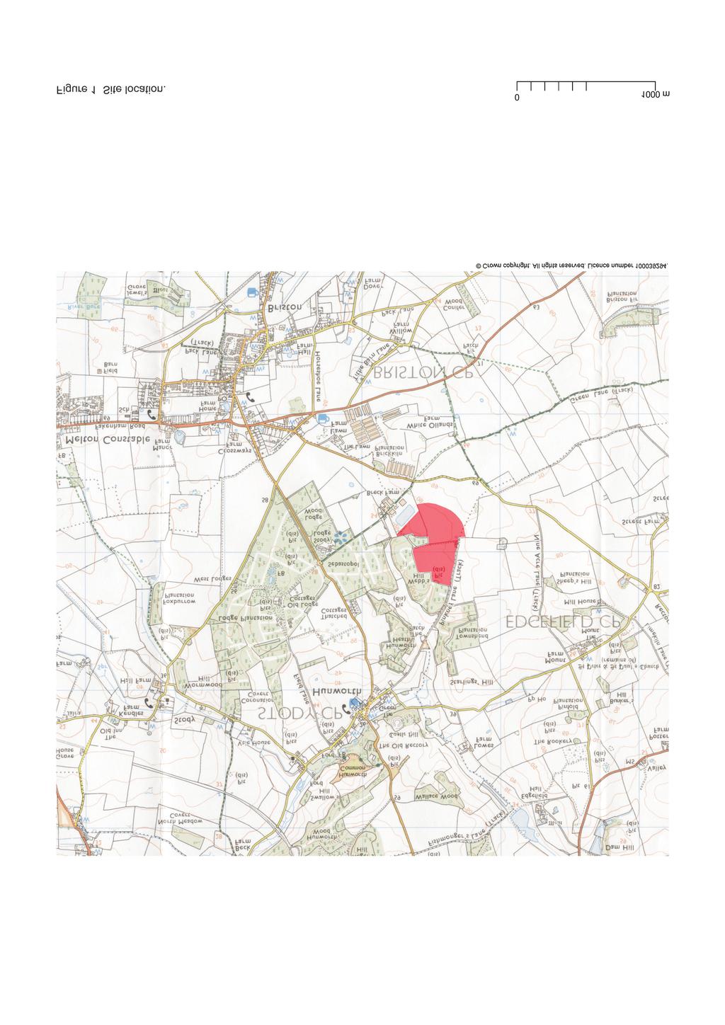
2 Contents 1 Summary 2 2 Introduction 2 3 Archaeological background 2 4 Aim 3 5 Methodology 3 6 Finds from fieldwalking survey by Adam Wightman, Howard Brooks, and Emma Spurgeon. 3 7 Finds from metal-detecting survey, by Emma Spurgeon 4 8 Discussion 6 9 Archive deposition 6 10 Acknowledgements 6 11 References 7 12 Glossary 7 13 NLA Brief 9 Figures after p 12 List of figures Fig 1 Site location. Fig 2 Survey results.
3 1 Summary An archaeological survey by fieldwalking and metal-detecting on a 9.63 ha site at Breck Farm, Stody, recovered very few finds (none of them in significant clusters). The fieldwalking survey recovered three post-medieval pottery sherds, a prehistoric struck flint, and seven brick or tile fragments. The metal-detecting survey recovered thirty-nine items of metalwork. The only significant piece being a World War II, American copper-alloy cap badge. Most of the metal-detecting finds were iron objects (probably fragments of agricultural equipment) or horseshoe fragments. They probably date to the 18th-20th centuries. 2 Introduction 2.1 This is the report on an archaeological survey by fieldwalking and metal-detecting carried out on behalf of clients by Colchester Archaeological Trust on arable land adjacent to Breck Farm, Stody, Norfolk (site centre: TG ). 2.2 Because the development proposal (minerals) would affect a site of unknown archaeological importance, any Planning Permission would be subject to a condition for a Programme of Archaeological Work. Related planning policies include: East of England Regional Assembly, East of England Plan: Revision to the Regional Spatial Strategy for the East of England (May 2008), Policy ENV5: The Historic Environment: Norfolk Minerals Local Plan Review Deposit Version (Norfolk County Council, September 2000), policies MIN 7-8; and Planning Policy Guidance 16, Archaeology and Planning (Department of the Environment s November 1990). 2.3 The Programme of Archaeological Work consisted initially of a geophysical survey using Bartington 1m fluxgate magnetometers carried out by the Bartlett-Clark Consultancy in 2008 (Bartlett and Prince 2008). The survey produced relatively few findings. A large proportion of the detected anomalies were relatively small and weak, and did not suggest any clusters or concentrations of particular interest. Limited positive findings included a linear feature probably caused by cultivation, and possible traces of former ditches or field boundaries, or perhaps land drains. 2.4 Following the geophysical survey, Norfolk Landscape Archaeology (NLA) recommended a systematic fieldwalking and metal-detecting survey to determine the date and extent of artefactual evidence within the ploughsoil. Details of the required survey are given in Brief for archaeological evaluation by fieldwalking and systematic metal-detecting survey at land adjacent to Breck Farm, Stody, Norfolk (NLA 2010) 3 Archaeological background The proposed development affects a site of unknown archaeological importance. The site occupies a large area (over 18ha) on the south side of the Glaven Valley, opposite the earthworks of Castle Hill. Hence the area had high potential to contain deposits of archaeological significance. There was a geophysical survey on this site prior to the fieldwalking and metaldetecting survey reported on here (see 2.3, above).
4 4 Aim The aim was, by carrying out systematic field walking and metal-detecting surveys, to determine the extent, date and significance of artefactual evidence within the ploughsoil. 5 Methodology (Fig 2) 5.1 Fieldwalking survey The field-walking survey followed standard methodology for a 10% surface collection (i.e., by searching 2m-wide corridors at 20m-spacing, thus giving a 10% coverage of the site). The recording system is based on the hectare block. Within each hectare, there are 25 separate collection boxes labelled A-Z (but missing I ). Finds are therefore referenced to the hectare and box, for instance Hectare 2, box K, or Hectare 4, box B. The metal-detecting survey grid is shown on Fig This methodology is described in EAA 14 (page 10) and in the CAT Method Statement (CAT 2010) which followed the NLA Brief (NLA 2010) All surface finds were collected (apart from obviously modern finds such as rope, plastic bags, or hazardous material such as asbestos fragments) All finds were washed and marked with a unique code for example A 26 B, to denote the kilometre, hectare and 20-m box from which they were collected All finds were classified and dated, in order that plots of the different finds types can appear as figures in this report (see Fig 2). 5.2 Metal-detecting survey The survey was carried out to the same methodology as is used in fieldwalking survey collection (i.e., by searching 2m-wide corridors at 20m-spacing, thus giving a 10% coverage of the site). 6 Finds from fieldwalking survey (Fig 2) 6.1 Lithics by A Wightman A 49 Z. Small tertiary flake (23 x 22 x 3mm) of grey flint. Evidence of three previous flake removals, platform preparation and a 'serrated' distal edge, which could be a denticulated edge, use-wear, or simply a result of plough damage. Prehistoric. 6.2 Post-medieval pottery by Howard Brooks Fabric descriptions are after Jennings et al 1981, and Colchester Archaeological Report 7 (CAR 7). Three sherds were collected. This is a small quantity of finds, given the size of the survey area (9.63 ha). Few comments can be made about such a small group. Conventional wisdom is that post-medieval and later sherds have not been ploughed up from underlying archaeological strata, but are the result of recent manure spreading. If so, it would seem that this land may have been pasture in recent centuries.
5 A 49 V 1 body sherd of modern ironstone willow pattern (ie CAR 7 fabric 48d). 5g. 19th 20th century. A 58 E 1 rim sherd of jug in Jennings fabric GRE (Glazed Red Earthenware), 5g. 17th- 18th century. B 52 B Base of jar in Westerwald ware, 16g. 17th-18th century. 6.3 Brick and tile table by E Spurgeon Field Grid Square Description Weight (g) Date A 47 T Peg-tile fragment 41.5 Post-medieval or modern A 48 L Peg-tile fragment 24.4 Post-medieval or modern A 49 S Tile fragment 1.9 Post-medieval or modern A 50 J Tile fragment 48.2 Post-medieval or modern A 58 U Brick/tile fragment Modern B 42 K Brick fragment 6.7 Modern B 51 U Brick fragment 13.7 Modern 7 Finds from metal-detecting survey (Fig 2) 7.1 Small Finds and bulk ironwork by E Spurgeon Summary The small finds include three copper-alloy and one lead small find, the most significant and only closely datable find is SF6, a cap badge from an American enlisted airman from World War II. The majority of the assemblage consists of iron objects (most likely fragments of agricultural equipment) alongside a number of horseshoe fragments. None of the finds can be closely dated but are most likely from the 18 th to 20 th century. Measurements are based on corroded sizes. Lead and copper-alloy SF1, field A, grid 48 sq X. Small lead strip. Twisted once in the centre, length mm, Width mm, thickness 6.24 mm. Dated to post medieval to modern. SF6, field A, grid 58, sq N. Copper alloy US Air Force WWII enlisted cap badge. AAC up with swept wings, style 44. No evidence of the point of attachment on the reverse remains. 3.5g. SF11 field A, grid 68, sq I. Copper alloy button. Plain with a flat head, head width mm. Dated 18 th to 20 th century. SF25 field A, grid 58, sq C. Copper-alloy coin or disc. No markings or stamp visible, 3.5g. Dated 19 th to 20 th century. Iron SF2, field A, grid 48 sq V. Iron object. Sheet fragment with an L shaped oval section handle, probably an attachment point for agricultural machinery. Handle, L mm, W mm, D mm. Dated 18 th to 20 th century.
6 SF3, field A, grid 57, sq T. 1) Iron horseshoe fragment from a large horseshoe. Surviving length mm, thickness mm. Dated 18 th to 19 th century. 2) semi rectangular lump: length mm, width mm, thickness mm. 3) iron strip, length mm, width mm, thickness mm. 4) Iron tapering strip, length mm, width at widest part mm, width at thinnest part mm, thickness mm. All dated between 18 th to 20 th century. SF4, field A, grid 58, sq D. Iron horseshoe fragment from a large horse, possibly something like a Shire horse. Surviving length mm, thickness mm. Dated 18 th to 20 th century. SF5, field A, grid 58, sq M. 1) Iron strip, length mm, width mm, D mm. 2) Iron rod. Slightly curved with a D shaped section, length mm, width mm, thickness mm. Both dating between 18 th to 20 th century. SF7 field A, grid 58, sq P. Iron hook, length 63.66, shaft width mm, hook size mm, probably agricultural or possibly from the fishing industry. Dated 18 th to 20 th century. SF8 field A, grid 58, sq S. Iron file. Triangular in section, length , width mm. Dated 18 th to 20 th century. SF9 field A, grid 59, sq E. Iron strip, possibly a fragment of a tool, length mm, width mm, thickness mm. Dated 18 th to 20 th century. SF10 field A, grid 59, sq V. Iron pipe/monkey wrench. Missing the lower jaw, length mm. Dated 18 th to 20 th century. SF12 field A, grid 69, sq F. Iron horseshoe from a large horse, Surviving length mm, thickness mm. Dated 18 th to 20 th century. SF13 field B, grid 31, sq H. Iron object. Slightly C shaped, length mm, width mm, thickness mm. Dated 18 th to 20 th century. SF14 field B, grid 41, sq E. 1) Iron object, similar to SF13, length mm, width mm, thickness 6.52 mm. 2) Iron strip fragment, length mm, width mm, thickness mm. Both dated between 18 th to 20 th century. SF15 field B, grid 41, sq R. Iron object. Almost triangular in shape. In one of the corners there is a slightly rounded protrusion that could possibly be the beginning of a tang. Surviving length , width at widest part mm, thickness mm. probably a fragment of agricultural equipment but possibly a fragment of a tool. Dated 18 th to 20 th century. SF16 field B, grid 16, sq V. 1) Iron object. L shaped, on of the edges is original, length mm, width of part with the original edge mm, width of the adjoining edge mm, thickness mm. Most likely a part of a blade from agricultural machinery. The side with the original edge is similar to SF13 and SF14. 2) Iron triangular sheet fragment, length mm, width mm, thickness mm. Both dated between 18 th to 20 th century. SF17 field B, grid 51, sq F. Iron sheet fragment. Almost rectangular in shape, length mm, width mm, thickness mm. Dated 18 th to 20 th century. SF18 field B, grid 51, sq P. Iron strip, length mm, width mm, thickness 7.56 mm. Dated 18 th to 20 th century. SF19 field B, grid 52, sq B. Iron object, similar to SF13-14, length mm, width mm SF20 field B, grid 52, sq E. Iron bolt, with complete head and partial shank. Surviving length mm, head width mm, shank width mm. Dated 18 th to 20 th century. SF21 field B, grid 52, sq G. Iron object. Amorphous fragment, length mm, width mm, thickness mm. Dated 18 th to 20 th century. SF22 field B, grid 52, sq W. Iron horseshoe fragment. From a small horse or pony. Surviving length mm, thickness 8.66 mm. Dated 18 th to 20 th century.
7 SF23 field B, grid 52, sq X. Iron object. Small amorphous blob, length mm, width mm, thickness 6.04 mm. Dated 18 th to 20 th century. SF24 field B, grid 52, sq Y. Iron tapering strip. Rounded tip, length mm, width at widest end mm, width at tip mm, thickness mm. Possibly part of the blade from a harrow. Dated 18 th to 20 th century. 7.2 Iron nails by E Spurgeon Nails have a round flat or slightly convex head unless otherwise specified. Those described as complete may lack the last few millimetres of the shank. 1) Field A, grid 49, sq Y. Complete iron nail, length 50.1 mm 2) Field A, grid 58, sq D. Almost complete iron nail, clenched, length mm 3) Field A, grid 69, sq F. Complete iron nail, length mm 4) Field A, grid 79, sq C. Complete iron nail with rectangular head, length mm 5) Field B, grid 41, sq A. a) Almost complete iron nail, length mm. b) iron nail shank fragment, length mm. 6) Field B, grid 41, sq I. Complete clenched iron nail, length mm 7) Field B, grid 52, sq A. Complete nail, length mm 8) Field B, grid 52, sq B. Compete whole nail, length mm 9) Field B, grid 52, sq G. Almost complete iron nail, surviving length mm 8 Discussion Apart from a quantity of agricultural ironwork, there were very few finds. Those which might be regarded as significant (a World-War II cap badge, three postmedieval potsherds and a prehistoric flint) are in such low densities that that their value as evidence of past activity is limited. The sparsity of potsherds (usually brought onto the land during manure spreading) might imply that this land was pasture in recent centuries. The survey supports the findings of the 2008 geophysical survey, that this site has not been the focus of any significant activity in the past apart from recent agricultural operations. 9 Archive deposition The paper archive and find are currently held by CAT at 12 Lexden Road, Colchester, Essex, but will be permanently deposited with Norfolk Museums Service (reference ENF ). 10 Acknowledgements This project was commissioned and funded by Mineral Services Ltd, Oak Barn Offices, Thorington Street, Stoke By Nayland, CO6 4SP, to whom we are grateful. Site work directed by B Holloway, assisted by M Baister, B Hurrell, C Lister, N Rayner, and A Wightman. EDM plots by A Wightman and C Lister. Illustrations by CL. The project was monitored by James Albone for Norfolk County Council. Thanks to James Albone for his input and assistance, and to Hazel White and Sarah Howard of Norfolk Museums for assistance with accession codes.
8 11 References Bartlett, ADH, and Prince, FS 2008 Breck Farm, Report on Archaeogeophysical Survey 2008 (surveyed by Bartlett- Clark Consultancy) CAT 2010 Method Statement for a field-walking and metal-detecting survey, and a linear trenched evaluation on the proposed reservoir site, Stratton Hall, Levington, Suffolk. January 2010 CAR Colchester Archaeological Report 7: Post-Roman pottery from excavations in Colchester, , by John Cotter DoE 1990 Planning Policy Guidance 16: Archaeology and Planning EAA Standards for field archaeology in the East of England, East Anglian Archaeology, Occasional Papers, 14, ed by D Gurney East of England Regional Assembly May 2008 East of England Plan: Revision to the Regional Spatial Strategy for the East of England (Policy ENV5). IfA 2008a Standard and guidance for an archaeological field evaluation IfA 2008b Standard and guidance for the collection, documentation, conservation and research of archaeological materials Jennings, S, et al 1981 (2004 reprint) Eighteen centuries of pottery from Norwich, East Anglian Archaeology 13, by Sarah Jennings, with MM Karshner, WF Milligan, and SV Williams MAP Management of archaeological projects, second edition (English Heritage) Norfolk County Council September 2000 The Historic Environment: Norfolk Minerals Local Plan Review Deposit Version (policies MIN 7-8). NLA 2010 Brief for archaeological evaluation by fieldwalking and systematic metal-detecting survey at land adjacent to Breck Farm, Stody, Norfolk (NLA, 19 March 2010) 12 Glossary AOD above ordnance datum context on an excavation site, a specific location (especially of finds) feature something excavated, ie a wall, a floor, a pit, a ditch, etc IfA Institute for Archaeologists medieval period from AD 1066 to c AD 1500 modern period from c AD 1800 to the present natural geological deposit undisturbed by human activity NLA Norfolk Landscape Archaeology NGR National grid reference post-medieval after c AD 1500 to c AD 1800 prehistoric the years BC
9 13 NLA Brief Brief for Archaeological Evaluation by Fieldwalking Survey at Breck Farm, Stody Norfolk Landscape Archaeology BRIEF FOR ARCHAEOLOGICAL EVALUATION BY FIELDWALKING AND SYSTEMATIC METAL DETECTING SURVEY AT Land adjacent to Breck Farm Stody NORFOLK PLANNING AUTHORITY: Norfolk County Council PLANNING APPLICATION NO.: SP/C/1/2008/1014 NLA REFERENCE CNF41624 ASSOCIATED. Y/N NHER NO. FOR THIS PROJECT: To be arranged GRID REFERENCE: TG MAP EXTRACT ATTACHED: No DEVELOPMENT PROPOSAL: Minerals AREA: 18ha CURRENT LAND USE: Agricultural ISSUED BY: Ken Hamilton Head of Archaeological Planning Norfolk Landscape Archaeology Union House, Gressenhall Dereham, Norfolk NR20 4DR Tel: (direct) Fax: DATE: 19/03/2010 If need this document in large print, audio, Braille, alternative format or in a different language please contact Ken Hamilton on and we will do our best to help.
10 Brief for Archaeological Evaluation by Fieldwalking Survey at Breck Farm, Stody Summary The development proposal affects a site of unknown archaeological importance. Planning Permission has been or may be granted subject to a condition for a Programme of Archaeological Work (hereafter PoAW). Field survey is required in the first instance to determine the date and extent of artefactual evidence within the ploughsoil. This Evaluation may indicate a need for a further phase of trial trenching if significant scatters of archaeological finds in the ploughsoil are located. Trial trenching may then indicate a need for Archaeological Excavation or an Archaeological Watching Brief during the development if features of importance exist on the site and these cannot be preserved in situ. Archaeological Contractors are reminded that they should submit a copy of their Method Statement or Specification to Norfolk Landscape Archaeology (NLA) for approval, before costs are prepared for commissioning clients, in line with the Institute of Field Archaeologists guidance. 1. Policy Background. The relevant planning policies can be found in : East of England Regional Assembly, East of England Plan: Revision to the Regional Spatial Strategy for the East of England (May 2008), Policy ENV5: The Historic Environment. Norfolk County Council's Norfolk Minerals Local Plan Review Deposit Version (September 2000), policies MIN 7-8. and The Department of the Environment s Planning Policy Guidance 16, Archaeology and Planning (November 1990). 2. Archaeological Background. The proposed development affects a site of unknown archaeological importance. The site occupies a large area (over 18ha) on the south side of the Glaven Valley, opposite the earthworks of Castle Hill. Hence the area has high potential to contain deposits of archaeological significance. 3. Planning Background. Planning Permission has been or may be granted, subject to a condition for a PoAW. This Brief provides an outline of the first phase of the PoAW, the results of which will be assessed by NLA to determine whether further investigations (trial trenching and/or excavation) are necessary should archaeological remains be found to exist on the site and these cannot be preserved in situ. 4. Requirement for Work. Field survey by systematic field walking and metal-detecting is required to determine the extent, date and significance of artefactual evidence within the ploughsoil. The Archaeological Contractor will prepare a Method Statement or Specification for this phase of the PoAW and submit this to NLA for approval before costs are prepared for the commissioning client. The PoAW will include, as appropriate, background research, fieldwork, assessment, analysis, preparation of report, publication and deposition of the project archive.
11 The Archaeological Contractor will contact the HER Officer of NLA in advance of work starting to obtain a HER number for the site or, if a number is already given on the Brief, to ensure that it is still applicable. The archaeological research aims and objectives of the project will be clearly stated, and the Method Statement or Specification will demonstrate how these will be met. Appropriate reference will be made to the following documents:- Glazebrook, J. (ed) 1997, Research and Archaeology: a Framework for the Eastern Counties, 1. Resource assessment (E. Anglian Archaeol. Occ. Pap. 3). Brown, N. and Glazebrook, J. (eds), 2000, Research and Archaeology: a Framework for the Eastern Counties, 2. Research agenda and strategy (E. Anglian Archaeol. Occ. Pap. 8). At the start of work (immediately before fieldwork commences) an OASIS online record must be initiated and key fields completed on Details, Location and Creators forms. When the project is completed, all parts of the OASIS online form must be completed for submission to the Norfolk Historic Environment Record. This will include an uploaded.pdf version of the entire report. Hard copies of the report must also be provided, as specified below. 5. Standards. Method Statements or Specifications prepared by Archaeological Consultants or Contractors should state that all works will be carried out in full accordance with the appropriate sections of Gurney, D., 2003, Standards for Field Archaeology in the East of England, as adopted by the Association of Local Government Archaeological Officers for the East of England Region and published as East Anglian Archaeology Occasional Paper 14. This is available as a PDF file on the web at Archaeological Contractors should note that the Standards document stipulates basic methodological standards. It is considered axiomatic that all contractors will strive to achieve the highest possible qualitative standards, with the application of the most advanced and appropriate techniques possible within a context of continuous improvement aimed at maximising the recovery of archaeological data and contributing to the development of a greater understanding of Norfolk s historic environment. Monitoring officers will seek and expect clear evidence of commitment to the historic resource of Norfolk, with specifications being drawn up within a context of added value. 6. Other matters Archaeological Contractors are reminded that they should submit a copy of their Method Statement or Specification to NLA for approval, before costs are prepared for commissioning clients, in line with the Institute of Field Archaeologists guidance. The Method Statement or Specification should indicate the number of person days allocated to the fieldwork stage of the project. NLA will be responsible for monitoring progress and standards throughout the project. The archaeological contractor will give NLA not less than two week's written notice of the commencement of the work so that arrangements for monitoring the project can be made. Any subsequent variation to a Detailed Project Specification or Method Statement must be agreed with NLA prior to its implementation.
12 This brief is valid for a period of one year from the date of issue. After that time, it may need to be revised to take account of new discoveries, changes in policy or the introduction of new working practices or techniques. Three hard copies and PDF copy on CD of the Assessment Report and Updated Project Design should be supplied to NLA for the attention of the Head of Archaeological Planning within the stipulated time-scale on the understanding that this will become a public document after an appropriate period of time (generally not exceeding six months). Three hard copies and a PDF copy of the draft publication report will be supplied to NLA for comments within stipulated or agreed time-scale for the completion of fieldwork. Contractors may wish to submit drafts for comments prior to sending the rest of the copies. A fourth hard copy of both reports should be sent directly to J. Heathcote, Regional Advisor for Archaeological Science, English Heritage, Brooklands House, 24 Brooklands Avenue, Cambridge CB2 2BU. 7. Notes for Applicants/developers NLA is responsible for safeguarding the County's archaeological heritage. NLA is consulted by Local Planning Authorities and provides specialist information and advice on the archaeological implications of development proposals. An Archaeological Project will usually consist of one or more of the following: Desk-based assessment: a report drawing together existing information about a site from a wide range of sources. Survey: usually fieldwalking and metal-detecting, sometimes non-intrusive geophysical surveys (e.g. magnetometer survey) Evaluation: survey and/or trial-trenching or test-pitting. Excavation: larger-scale excavation Watching brief or monitoring: the presence of an archaeologist during the development to record any features exposed Post-excavation: analysis, and the preparation of a report and archive of records and finds at the end of any archaeological project A phased approach to fieldwork is frequently adopted, with one stage leading on to another (if necessary) after each phase is reported upon and reviewed. If an evaluation is required before an application is determined or if Planning Permission is granted subject to a condition for a programme of archaeological work, NLA will provide a Brief for the archaeological project. This outline of the project is forwarded to you by NLA or the Planning Authority. You should then ask one or more Archaeological Contractors to prepare a Method Statement or Specification which will detail how the project is to be undertaken, and how the brief will be fulfilled. This will be sent to NLA for approval on behalf of the Planning Authority, after which the Contractor will give you details of costs. Details of archaeological contractors based in Norfolk and beyond may be found in the Institute of Field Archaeologists Yearbook & Directory, available from the I.F.A., University of Reading, 2 Earley Gate, PO Box 239, Reading RG6 6AU. Tel: Fax: admin@archaeologists.net. Website: NLA does not see Contractors' costings, nor do we give advice on the costs of archaeological projects. This is between you and the archaeological contractor(s). You may wish to obtain a number of quotations or to employ the services of an archaeological consultant. For further information or advice on any archaeological matters please contact the person issuing this report whose details are on Page1.
13 Colchester Archaeological Trust 2010 Distribution list: Mineral Services Ltd. Norfolk Landscape Archaeology Norfolk Museums Service English Heritage. Colchester Archaeological Trust 12 Lexden Road, Colchester, Essex CO3 3NF tel.: (01206) (01206) checked by: Philip Crummy date: PC c:/projects/projects 10/Breck Farm Stody/report547.doc
14
15 E J P U Z D I N T Y C H M 70 S X B G L R W A F K Q V Area Kilometre B Kilometre A Area 3 Area m potsherd flint cu alloy button Fig 2 Results of fieldwalking and metal detector survey, with insert showing individual hectare methodology.
An archaeological evaluation at 16 Seaview Road, Brightlingsea, Essex February 2004
 An archaeological evaluation at 16 Seaview Road, Brightlingsea, Essex February 2004 report prepared by Kate Orr on behalf of Highfield Homes NGR: TM 086 174 (c) CAT project ref.: 04/2b ECC HAMP group site
An archaeological watching brief and recording at Brightlingsea Quarry, Moverons Lane, Brightlingsea, Essex October 2003
 An archaeological watching brief and recording at Brightlingsea Quarry, Moverons Lane, Brightlingsea, Essex commissioned by Mineral Services Ltd on behalf of Alresford Sand & Ballast Co Ltd report prepared
An archaeological evaluation in the playground of Colchester Royal Grammar School, Lexden Road, Colchester, Essex
 An archaeological evaluation in the playground of Colchester Royal Grammar School, Lexden Road, Colchester, Essex February 2002 on behalf of Roff Marsh Partnership CAT project code: 02/2c Colchester Museum
Archaeological evaluation at the Onley Arms, The Street, Stisted, Essex
 Archaeological evaluation at the Onley Arms, The Street, Stisted, Essex November 2014 report by Pip Parmenter and Adam Wightman with a contribution from Stephen Benfield and illustrations by Emma Holloway
An archaeological watching brief at Sheepen, Colchester, Essex November-December 2003
 An archaeological watching brief at Sheepen, Colchester, Essex November-December 2003 report prepared by Ben Holloway on behalf of Colchester Borough Council CAT project ref.: 03/11c Colchester Museums
Archaeological trial-trenching evaluation at Chappel Farm, Little Totham, Essex. April 2013
 Archaeological trial-trenching evaluation at Chappel Farm, Little Totham, Essex April 2013 report prepared by Ben Holloway commissioned by Tim Harbord Associates on behalf of Mr Tom Howie Planning reference:
An archaeological evaluation at the Lexden Wood Golf Club (Westhouse Farm), Lexden, Colchester, Essex
, Lexden, Colchester, Essex") An archaeological evaluation at the Lexden Wood Golf Club (Westhouse Farm), Lexden, Colchester, Essex January 2000 Archive report on behalf of Lexden Wood Golf Club Colchester Archaeological Trust 12 Lexden
An archaeological evaluation at the Lexden Wood Golf Club (Westhouse Farm), Lexden, Colchester, Essex January 2000 Archive report on behalf of Lexden Wood Golf Club Colchester Archaeological Trust 12 Lexden
An archaeological evaluation at the Blackwater Hotel, Church Road, West Mersea, Colchester, Essex March 2003
 An archaeological evaluation at the Blackwater Hotel, Church Road, West Mersea, Colchester, Essex report prepared by Laura Pooley on behalf of Dolphin Developments (U.K) Ltd NGR: TM 0082 1259 CAT project
Colchester Archaeological Trust Ltd. A Fieldwalking Survey at Birch, Colchester for ARC Southern Ltd
 Colchester Archaeological Trust Ltd A Fieldwalking Survey at Birch, Colchester for ARC Southern Ltd November 1997 CONTENTS page Summary... 1 Background... 1 Methods... 1 Retrieval Policy... 2 Conditions...
An archaeological evaluation by trial-trenching at Playgolf, Bakers Lane, Westhouse Farm, Colchester, Essex
 An archaeological evaluation by trial-trenching at Playgolf, Bakers Lane, Westhouse Farm, Colchester, Essex commissioned by Mr Stephen Belchem on behalf of ADP Ltd. report prepared by Chris Lister Planning
An archaeological evaluation by trial-trenching at Scotts Farm, Lodge Lane, Purleigh, Essex October 2011
 An archaeological evaluation by trial-trenching at Scotts Farm, Lodge Lane, Purleigh, Essex October 2011 report prepared by Adam Wightman on behalf of Richard Emans CAT project ref.: 11/10a NGR: TL 582719
Grim s Ditch, Starveall Farm, Wootton, Woodstock, Oxfordshire
 Grim s Ditch, Starveall Farm, Wootton, Woodstock, Oxfordshire An Archaeological Recording Action For Empire Homes by Steve Ford Thames Valley Archaeological Services Ltd Site Code SFW06/118 November 2006
An archaeological evaluation at Thistle Hall, Mope Lane, Wickham Bishops, Essex July 2009
 An archaeological evaluation at Thistle Hall, Mope Lane, Wickham Bishops, Essex July 2009 report prepared by Howard Brooks and Ben Holloway on behalf of Clarity Ecoworks Ltd CAT project ref.: 09/1f ECC
Fieldwalking at Cottam 1994 (COT94F)
") Fieldwalking at Cottam 1994 (COT94F) Tony Austin & Elizabeth Jelley (19 Jan 29) 1. Introduction During the winter of 1994 students from the Department of Archaeology at the University of York undertook
Fieldwalking at Cottam 1994 (COT94F) Tony Austin & Elizabeth Jelley (19 Jan 29) 1. Introduction During the winter of 1994 students from the Department of Archaeology at the University of York undertook
Report on an archaeological trial-trenching evaluation: proposed reservoir site, land north of Redgate House, Wherstead, Suffolk.
 Report on an archaeological trial-trenching evaluation: proposed reservoir site, land north of Redgate House, Wherstead, Suffolk. August-September 2010 report prepared by Ben Holloway and Howard Brooks
An archaeological watching brief at St Leonard s church, Hythe Hill, Colchester, Essex
 An archaeological watching brief at St Leonard s church, Hythe Hill, Colchester, Essex report prepared by Adam Wightman on behalf of Dorvell Construction CAT project ref.: 10/5d Colchester and Ipswich
New Composting Centre, Ashgrove Farm, Ardley, Oxfordshire
 New Composting Centre, Ashgrove Farm, Ardley, Oxfordshire An Archaeological Watching Brief For Agrivert Limited by Andrew Weale Thames Valley Archaeological Services Ltd Site Code AFA 09/20 August 2009
Church of St Peter and St Paul, Great Missenden, Buckinghamshire
 Church of St Peter and St Paul, Great Missenden, Buckinghamshire An Archaeological Watching Brief for the Parish of Great Missenden by Andrew Taylor Thames Valley Archaeological Services Ltd Site Code
2 Saxon Way, Old Windsor, Berkshire
 2 Saxon Way, Old Windsor, Berkshire An Archaeological Watching Brief For Mrs J. McGillicuddy by Pamela Jenkins Thames Valley Archaeological Services Ltd Site Code SWO 05/67 August 2005 Summary Site name:
39, Walnut Tree Lane, Sudbury (SUY 073) Planning Application No. B/04/02019/FUL Archaeological Monitoring Report No. 2005/112 OASIS ID no.
 Planning Application No. B/04/02019/FUL Archaeological Monitoring Report No. 2005/112 OASIS ID no.") 39, Walnut Tree Lane, Sudbury (SUY 073) Planning Application No. B/04/02019/FUL Archaeological Monitoring Report No. 2005/112 OASIS ID no. 9273 Summary Sudbury, 39, Walnut Tree Lane, Sudbury (TL/869412;
39, Walnut Tree Lane, Sudbury (SUY 073) Planning Application No. B/04/02019/FUL Archaeological Monitoring Report No. 2005/112 OASIS ID no. 9273 Summary Sudbury, 39, Walnut Tree Lane, Sudbury (TL/869412;
Silwood Farm, Silwood Park, Cheapside Road, Ascot, Berkshire
 Silwood Farm, Silwood Park, Cheapside Road, Ascot, Berkshire An Archaeological Watching Brief For Imperial College London by Tim Dawson Thames Valley Archaeological Services Ltd Site Code SFA 09/10 April
An archaeological watching brief and evaluation at Great Notley business park, near Braintree, Essex June-September 2005
 An archaeological watching brief and evaluation at Great Notley business park, near Braintree, Essex report prepared by Kate Orr commissioned by Andrew Martin Associates Ltd on behalf of Countryside Properties
Archaeological evaluation by trial-trenching on land adjacent to 25 East Hill, Colchester, Essex, CO1 2QX September 2015
 Archaeological evaluation by trial-trenching on land adjacent to 25 East Hill, Colchester, Essex, CO1 2QX September 2015 by Laura Pooley with contributions by Stephen Benfield, illustrations by Chris Lister
An archaeological watching brief on one section of an Anglian Water main Spring Lane, Lexden, Colchester
 An archaeological watching brief on one section of an Anglian Water main Spring Lane, Lexden, Colchester April-September 2001 on behalf of Breheny Contractors CAT project ref.: 01/4D Colchester Museum
Essex Historic Environment Record/ Essex Archaeology and History
 Essex Historic Environment Record/ Essex Archaeology and History CAT Report 578 Summary sheet Address: Kingswode Hoe School, Sussex Road, Colchester, Essex Parish: Colchester NGR: TL 9835 2528 Type of
ARCHAEOLOGICAL EVALUATION AT BRIGHTON POLYTECHNIC, NORTH FIELD SITE, VARLEY HALLS, COLDEAN LANE, BRIGHTON. by Ian Greig MA AIFA.
 ARCHAEOLOGICAL EVALUATION AT BRIGHTON POLYTECHNIC, NORTH FIELD SITE, VARLEY HALLS, COLDEAN LANE, BRIGHTON by Ian Greig MA AIFA May 1992 South Eastern Archaeological Services Field Archaeology Unit White
Archaeological trial-trenching evaluation at Dale Hall, Cox s Hill, Lawford, Essex
 Archaeological trial-trenching evaluation at Dale Hall, Cox s Hill, Lawford, Essex Fieldwork directed by Ben Holloway report prepared by Howard Brooks with a contribution by Stephen Benfield on behalf
ARCHAEOLOGICAL MONITORING REPORT
 ARCHAEOLOGICAL MONITORING REPORT SCCAS REPORT No. 2009/324 Thorington Hall, Stoke by Nayland SBN 087 HER Information Date of Fieldwork: November 2009 - January 2010 Grid Reference: TM 0131 3546 Funding
An archaeological evaluation by test-pitting on the putting green and in the nursery, Upper Castle Park, Colchester, Essex April 2007
 An archaeological evaluation by test-pitting on the putting green and in the nursery, Upper Castle Park, Colchester, Essex report prepared by Kate Orr on behalf of Colchester Borough Council CAT project
Cambridge Archaeology Field Group. Fieldwalking on the Childerley Estate Cambridgeshire
 Cambridge Archaeology Field Group Fieldwalking on the Childerley Estate Cambridgeshire 2009 to 2014 Summary Fieldwalking on the Childerley estate of Martin Jenkins and Family has revealed, up to March
Archaeological Watching Brief (Phase 2) at Court Lodge Farm, Aldington, near Ashford, Kent December 2011
 at Court Lodge Farm, Aldington, near Ashford, Kent December 2011") Archaeological Watching Brief (Phase 2) at Court Lodge Farm, Aldington, near Ashford, Kent December 2011 SWAT. Archaeology Swale and Thames Archaeological Survey Company School Farm Oast, Graveney Road
Archaeological Watching Brief (Phase 2) at Court Lodge Farm, Aldington, near Ashford, Kent December 2011 SWAT. Archaeology Swale and Thames Archaeological Survey Company School Farm Oast, Graveney Road
Fort Arbeia and the Roman Empire in Britain 2012 FIELD REPORT
 Fort Arbeia and the Roman Empire in Britain 2012 FIELD REPORT Background Information Lead PI: Paul Bidwell Report completed by: Paul Bidwell Period Covered by this report: 17 June to 25 August 2012 Date
Archaeological. Monitoring & Recording Report. Fulbourn Primary School, Cambridgeshire. Archaeological Monitoring & Recording Report.
 Fulbourn Primary School, Cambridgeshire Archaeological Monitoring & Recording Report October 2014 Client: Cambridgeshire County Council OA East Report No: 1689 OASIS No: oxfordar3-192890 NGR: TL 5190 5613
Cambridge Archaeology Field Group. Fieldwalking on the Childerley Estate, Cambridgeshire. Autumn 2014 to Spring Third interim report
 Cambridge Archaeology Field Group Fieldwalking on the Childerley Estate, Cambridgeshire Autumn 2014 to Spring 2015 Third interim report Summary Field walking on the Childerley estate of Martin Jenkins
Excavation. Post-Medieval Ditches. Land off Norwich Common Road Wymondham Norfolk. Excavation. Client: November 2013
 Land off Norwich Common Road Wymondham Norfolk. Excavation November 2013 Client: OA East Report No: 1546 OASIS No: oxfordar3-163105 NGR: TG 12770 02684 Excavation Post-Medieval Ditches Post-Medieval Ditches
7. Prehistoric features and an early medieval enclosure at Coonagh West, Co. Limerick Kate Taylor
 7. Prehistoric features and an early medieval enclosure at Coonagh West, Co. Limerick Kate Taylor Illus. 1 Location of the site in Coonagh West, Co. Limerick (based on the Ordnance Survey Ireland map)
An archaeological excavation of test-holes at St Barnabas Church, Alphamstone, Essex March and May 2007
 An archaeological excavation of test-holes at St Barnabas Church, Alphamstone, Essex March and May 2007 report prepared by Kate Orr commissioned by David Whymark Building Design and Conservation on behalf
Archaeological Material From Spa Ghyll Farm, Aldfield
 Archaeological Material From Spa Ghyll Farm, Aldfield Introduction Following discussions with Linda Smith the Rural Archaeologist for North Yorkshire County Council, Robert Morgan of 3D Archaeological
Former Whitbread Training Centre Site, Abbey Street, Faversham, Kent Interim Archaeological Report Phase 1 November 2009
 Former Whitbread Training Centre Site, Abbey Street, Faversham, Kent Interim Archaeological Report Phase 1 November 2009 SWAT. Archaeology Swale and Thames Archaeological Survey Company School Farm Oast,
16 members of the Fieldwalking Group met York Community Archaeologist Jon Kenny at Lou Howard s farm, Rose Cottage Farm, at
 Terrington History Group Fieldwalking Group Field 1 Final report 21 October 2011 - fieldwalking 16 members of the Fieldwalking Group met York Community Archaeologist Jon Kenny at Lou Howard s farm, Rose
ARCHAEOLOGICAL EVALUATION REPORT. Home Farm, Woolverstone
 ARCHAEOLOGICAL EVALUATION REPORT Home Farm, Woolverstone WLV 047 A REPORT ON THE ARCHAEOLOGICAL EVALUATION, 2007 Kieron Heard Field Team Suffolk County Council Archaeological Service December 2007 Lucy
Grange Farm, Widmer End, Hughenden, Buckinghamshire
 Grange Farm, Widmer End, Hughenden, Buckinghamshire An Archaeological Evaluation for British Flora by Andy Taylor Thames Valley Archaeological Services Ltd Site Code GFH 05/63 July 2005 Summary Site name:
The lithic assemblage from Kingsdale Head (KH09)
") 1 The lithic assemblage from Kingsdale Head (KH09) Hannah Russ Introduction During excavation the of potential Mesolithic features at Kingsdale Head in 2009 an assemblage of flint and chert artefacts were
1 The lithic assemblage from Kingsdale Head (KH09) Hannah Russ Introduction During excavation the of potential Mesolithic features at Kingsdale Head in 2009 an assemblage of flint and chert artefacts were
Neolithic and Roman remains on the Lufkins Farm reservoir site, Great Bentley, Essex October-November 2007
 Neolithic and Roman remains on the Lufkins Farm reservoir site, Great Bentley, Essex report prepared by Howard Brooks and Ben Holloway on behalf of A O Poole & Sons and George Wright Farms NGR: TM 0975
Erection of wind turbine, Mains of Loanhead, Old Rayne, AB52 6SX
 Erection of wind turbine, Mains of Loanhead, Old Rayne, AB52 6SX Ltd 23 November 2011 Erection of wind turbine, Mains of Loanhead, Old Rayne, AB52 6SX CONTENTS 1 INTRODUCTION 3 2 ARCHAEOLOGICAL BACKGROUND
Moray Archaeology For All Project
 School children learning how to identify finds. (Above) A flint tool found at Clarkly Hill. Copyright: Leanne Demay Moray Archaeology For All Project ational Museums Scotland have been excavating in Moray
3. The new face of Bronze Age pottery Jacinta Kiely and Bruce Sutton
 3. The new face of Bronze Age pottery Jacinta Kiely and Bruce Sutton Illus. 1 Location map of Early Bronze Age site at Mitchelstown, Co. Cork (based on the Ordnance Survey Ireland map) A previously unknown
Archaeological sites and find spots in the parish of Burghclere - SMR no. OS Grid Ref. Site Name Classification Period
 Archaeological sites and find spots in the parish of Burghclere - SMR no. OS Grid Ref. Site Name Classification Period SU45NE 1A SU46880 59200 Ridgemoor Farm Inhumation Burial At Ridgemoor Farm, on the
Novington, Plumpton East Sussex
 Novington, Plumpton East Sussex The Flint Over 1000 pieces of flintwork were recovered during the survey, and are summarised in Table 0. The flint is of the same types as found in the previous survey of
Suburban life in Roman Durnovaria
 Suburban life in Roman Durnovaria Additional specialist report Finds Ceramic building material By Kayt Brown Ceramic building material (CBM) Kayt Brown A total of 16420 fragments (926743g) of Roman ceramic
Monitoring Report No Sacred Heart Church Aghamore Boho Co. Fermanagh AE/10/116E. Brian Sloan L/2009/1262/F
 Monitoring Report No. 202 Sacred Heart Church Aghamore Boho Co. Fermanagh AE/10/116E Brian Sloan L/2009/1262/F Site Specific Information Site Address: Sacred Heart Church, Aghamore, Boho, Co. Fermanagh
ARCHAEOLOGICAL S E R V I C E S. St Nicholas' Church, Barrack Hill, Nether Winchendon, Buckinghamshire. Archaeological Watching Brief.
 T H A M E S V A L L E Y ARCHAEOLOGICAL S E R V I C E S St Nicholas' Church, Barrack Hill, Nether Winchendon, Buckinghamshire Archaeological Watching Brief by Steven Crabb Site Code: STW17/229 (SP 7735
Test-Pit 3: 31 Park Street (SK )
") -Pit 3: 31 Park Street (SK 40732 03178) -Pit 3 was excavated in a flower bed in the rear garden of 31 Park Street, on the northern side of the street and west of an alleyway leading to St Peter s Church,
-Pit 3: 31 Park Street (SK 40732 03178) -Pit 3 was excavated in a flower bed in the rear garden of 31 Park Street, on the northern side of the street and west of an alleyway leading to St Peter s Church,
Greater London GREATER LONDON 3/606 (E ) TQ
 TQ") GREATER LONDON City of London 3/606 (E.01.6024) TQ 30358150 1 PLOUGH PLACE, CITY OF LONDON An Archaeological Watching Brief at 1 Plough Place, City of London, London EC4 Butler, J London : Pre-Construct
GREATER LONDON City of London 3/606 (E.01.6024) TQ 30358150 1 PLOUGH PLACE, CITY OF LONDON An Archaeological Watching Brief at 1 Plough Place, City of London, London EC4 Butler, J London : Pre-Construct
Monitoring Report No. 99
 Monitoring Report No. 99 Enniskillen Castle Co. Fermanagh AE/06/23 Cormac McSparron Site Specific Information Site Name: Townland: Enniskillen Castle Enniskillen SMR No: FER 211:039 Grid Ref: County: Excavation
Archaeological Evaluation at Alconbury Weald Enterprise Zone
 Archaeological Evaluation at Alconbury Weald Enterprise Zone Archaeological Evaluation Report June 2015 Client: CgMS OA East Report No: 1768 OASIS No: oxfordar3-212519 NGR: TL 1975 7684 Archaeological
St Germains, Tranent, East Lothian: the excavation of Early Bronze Age remains and Iron Age enclosed and unenclosed settlements
 Proc Soc Antiq Scot, 128 (1998), 203-254 St Germains, Tranent, East Lothian: the excavation of Early Bronze Age remains and Iron Age enclosed and unenclosed settlements Derek Alexander* & Trevor Watkinsf
E x cav atio n R e p o r t
 Medieval Trackway on land at Ivy Farm Royston, Hertfordshire Excavation Report E x cav atio n R e p o r t October 2011 Client: CgMs Consulting OA East Report No: 1305 OASIS No: oxfordar3-112012 NGR: TL
Lanton Lithic Assessment
 Lanton Lithic Assessment Dr Clive Waddington ARS Ltd The section headings in the following assessment report refer to those in the Management of Archaeological Projects (HBMC 1991), Appendix 4. 1. FACTUAL
Archaeological trial-trenching evaluation on land west of Hams Farmhouse, Back Road, Trimley St Martin, Suffolk
 Archaeological trial-trenching evaluation on land west of Hams Farmhouse, Back Road, Trimley St Martin, Suffolk Fieldwork date: January 2014 report prepared by Ben Holloway and Howard Brooks with contributions
S E R V I C E S. St John the Baptist Church, Penshurst, Kent. Archaeological Watching Brief. by Daniel Bray and James McNicoll-Norbury
 T H A M E S V A L L E Y ARCHAEOLOGICAL S E R V I C E S St John the Baptist Church, Penshurst, Kent Archaeological Watching Brief by Daniel Bray and James McNicoll-Norbury Site Code: JPK11/25 (TQ 5273 4385)
A Fieldwalking Project At Sompting. West Sussex
 by John Funnell Introduction A Fieldwalking Project At Sompting. West Sussex During March -and April 1995 the Brighton and Hove Archaeological Society conducted fie1dwa1king in a field at Sompting West
FURTHER MIDDLE SAXON EVIDENCE AT COOK STREET, SOUTHAMPTON (SOU 567)
") Roc. Hampshire Field Club Archaeol. Soc 52,1997, 77-87 (Hampshire Studies 1997) FURTHER MIDDLE SAXON EVIDENCE AT COOK STREET, SOUTHAMPTON (SOU 567) By M F GARNER andj VINCENT with a contribution byjacqueline
Roc. Hampshire Field Club Archaeol. Soc 52,1997, 77-87 (Hampshire Studies 1997) FURTHER MIDDLE SAXON EVIDENCE AT COOK STREET, SOUTHAMPTON (SOU 567) By M F GARNER andj VINCENT with a contribution byjacqueline
Tepe Gawra, Iraq expedition records
 Tepe Gawra, Iraq expedition records 1021 Last updated on March 02, 2017. University of Pennsylvania, Penn Museum Archives July 2009 Tepe Gawra, Iraq expedition records Table of Contents Summary Information...
Museum of London Archaeological Archive: standards 2 Archive Components: Standards and Specifications 2.3 Finds
 Author Maloney, Cath. LAARC Version 3 Date 08/05/2013 Status Pre-publication Change History 2.9. Replacement of Registered Finds cards with image 2.3.4.3 2.8 Additions to Appendix: sample Finds Inventory
December 6, Paul Racher (P007) Archaeological Research Associates Ltd. 900 Guelph St. Kitchener ON N2H 5Z6
 Archaeological Research Associates Ltd. 900 Guelph St. Kitchener ON N2H 5Z6") Ministry of Tourism, Culture and Sport Culture Programs Unit Programs and Services Branch Culture Division 401 Bay Street, Suite 1700 Toronto ON M7A 0A7 Tel.: 416-314-2120 Ministère du Tourisme, de la
Ministry of Tourism, Culture and Sport Culture Programs Unit Programs and Services Branch Culture Division 401 Bay Street, Suite 1700 Toronto ON M7A 0A7 Tel.: 416-314-2120 Ministère du Tourisme, de la
Moated Site at Manor Farm, Islip, Oxfordshire
 Moated Site at Manor Farm, Islip, Oxfordshire An Archaeological Excavation By Jo Pine Site Code MFI05 December 2007 Summary Site name: Moated Site at Manor Farm, Islip, Oxfordshire Grid reference: SP 5298
Caistor Roman Project Interim Summary of 2015 Season of Test pits at Caistor Old Hall
 Caistor Roman Project Interim Summary of 2015 Season of Test pits at Caistor Old Hall Introduction This brief report summarises the first results of the 2015 campaign of test-pitting in the grounds of
Land North of Pesthouse Lane Barham Suffolk BRH 054
 Land North of Pesthouse Lane Barham Suffolk BRH 054 Archaeological Evaluation Report SCCAS Report No. 2012/142 Client: Barham Parish Council Author: Jezz Meredith September 2012 SCCAS Land North of Pesthouse
Whitton Church Lane (Recreation Ground) WHI 014
 WHI 014") ARCHAEOLOGICAL EVALUATION REPORT Whitton Church Lane (Recreation Ground) WHI 014 A REPORT ON THE ARCHAEOLOGICAL EVALUATION, 2008 (Planning app. no. 1362/05/FUL) Jezz Meredith Field Team Suffolk C.C. Archaeological
ARCHAEOLOGICAL EVALUATION REPORT Whitton Church Lane (Recreation Ground) WHI 014 A REPORT ON THE ARCHAEOLOGICAL EVALUATION, 2008 (Planning app. no. 1362/05/FUL) Jezz Meredith Field Team Suffolk C.C. Archaeological
January report prepared by Laura Pooley, Ben Holloway, Philip Crummy and Rob Masefield. on behalf of Taylor Woodrow
 Assessment report on the archaeological investigations carried out on Areas C1, C2, E, J1, O, Q and S1 of the Alienated Land, Colchester Garrison, including the Time Team trenches and the Alienated Land
THE RAVENSTONE BEAKER
 DISCOVERY THE RAVENSTONE BEAKER K. J. FIELD The discovery of the Ravenstone Beaker (Plate Xa Fig. 1) was made by members of the Wolverton and District Archaeological Society engaged on a routine field
Appendix 10.D Metal Detecting Report
 Appendix 10.D Metal Detecting Report Entec UK Limited Entec UK Limited KELMARSH WINDFARM SITE: NASEBY BATTLEFIELD Report on a survey undertaken by the Battlefields Trust on behalf of E.ON during October-December
Evidence for the use of bronze mining tools in the Bronze Age copper mines on the Great Orme, Llandudno
 Evidence for the use of bronze mining tools in the Bronze Age copper mines on the Great Orme, Llandudno Background The possible use of bronze mining tools has been widely debated since the discovery of
Greater London Region GREATER LONDON 3/567 (E.01.K099) TQ BERMONDSEY STREET AND GIFCO BUILDING AND CAR PARK
 TQ BERMONDSEY STREET AND GIFCO BUILDING AND CAR PARK") GREATER LONDON 3/567 (E.01.K099) TQ 33307955 156-170 BERMONDSEY STREET AND GIFCO BUILDING AND CAR PARK Assessment of an Archaeological Excavation at 156-170 Bermondsey Street and GIFCO Building and Car
GREATER LONDON 3/567 (E.01.K099) TQ 33307955 156-170 BERMONDSEY STREET AND GIFCO BUILDING AND CAR PARK Assessment of an Archaeological Excavation at 156-170 Bermondsey Street and GIFCO Building and Car
SERIATION: Ordering Archaeological Evidence by Stylistic Differences
 SERIATION: Ordering Archaeological Evidence by Stylistic Differences Seriation During the early stages of archaeological research in a given region, archaeologists often encounter objects or assemblages
Crouched Friars: the medieval church structure and its associated cemetery Crouch Street, Colchester: January-April 2007
 Crouched Friars: the medieval church structure and its associated cemetery. 38-40 Crouch Street, Colchester: January-April 2007 report prepared by Stephen Benfield and Howard Brooks on behalf of Bellway
Chapter 2. Remains. Fig.17 Map of Krang Kor site
 Chapter 2. Remains Section 1. Overview of the Survey Area The survey began in January 2010 by exploring the site of the burial rootings based on information of the rooted burials that was brought to the
THE EXCAVATION OF A BURNT MOUND AT HARBRIDGE, HAMPSHIRE
 Proc Hampshire Field ClubArchaeolSoc5i, 1999,172-179 (Hampshire Studies 1999) THE EXCAVATION OF A BURNT MOUND AT HARBRIDGE, HAMPSHIRE by S J SHENNAN ABSTRACT A burnt mound of Late Brome Age date, as indicated
Fieldwalk On Falmer Hill, Near Brighton - Second Season
 Fieldwalk On Falmer Hill, Near Brighton - Second Season by the Brighton and Hove Archaeological Society This report as well as describing the recent fieldwalks also includes descriptions of previous discoveries
Specialist Report 11 Worked Flint by Hugo Anderson-Whymark
 London Gateway Iron Age and Roman Salt Making in the Thames Estuary Excavation at Stanford Wharf Nature Reserve, Essex Specialist Report 11 Worked Flint by Hugo Anderson-Whymark Specialist Report 11 Worked
Search of Highland Sites & Monuments Record for Useable Mesolithic Information
 ScARF Palaeolithic & Mesolithic Panel Search of Highland Sites & Monuments Record for Useable Mesolithic Information Steven A Birch Introduction At the first ScARF Palaeolithic and Mesolithic panel meeting,
Archaeological Evaluation Report
 16-18 Church Street Brill Buckinghamshire o a February 2008 Client: Stephen Moss Developments Issue N o : 1 OA Job N o : 3858 Planning Ref N o : 06/01304 NGR: SP 6553 1377 Client Name: Stephen Moss Developments
Wantage County Primary School, Garston Lane, Wantage, Oxfordshire
 Wantage County Primary School, Garston Lane, Wantage, Oxfordshire An Archaeological Evaluation for Oxfordshire County Council by Erlend Hindmarch Thames Valley Archaeological Services Ltd Site Code GLW
Changing People Changing Landscapes: excavations at The Carrick, Midross, Loch Lomond Gavin MacGregor, University of Glasgow
 Changing People Changing Landscapes: excavations at The Carrick, Midross, Loch Lomond Gavin MacGregor, University of Glasgow Located approximately 40 kilometres to the south-west of Oban, as the crow flies
Cetamura Results
 Cetamura 2000 2006 Results A major project during the years 2000-2006 was the excavation to bedrock of two large and deep units located on an escarpment between Zone I and Zone II (fig. 1 and fig. 2);
An archaeological evaluation at Dry Street, Basildon, Essex May-June 2006
 An archaeological evaluation at Dry Street, Basildon, Essex May-June 2006 report prepared by Howard Brooks commissioned by Entec on behalf of English Partnerships CAT project ref: 06/5c Site code: BADS
SALVAGE EXCAVATIONS AT OLD DOWN FARM, EAST MEON
 Proc. Hants. Field Club Archaeol. Soc. 36, 1980, 153-160. 153 SALVAGE EXCAVATIONS AT OLD DOWN FARM, EAST MEON By RICHARD WHINNEY AND GEORGE WALKER INTRODUCTION The site was discovered by chance in December
Tips for proposers. Cécile Huet, PhD Deputy Head of Unit A1 Robotics & AI European Commission. Robotics Brokerage event 5 Dec Cécile Huet 1
 Tips for proposers Cécile Huet, PhD Deputy Head of Unit A1 Robotics & AI European Commission Robotics Brokerage event 5 Dec. 2016 Cécile Huet 1 What are you looking for? MAXIMISE IMPACT OF PROGRAMME on
Burrell Orchard 2014: Cleveland Archaeological Society Internship Amanda Ponomarenko The Ohio State University June - August 2014
 1 Burrell Orchard 2014: Cleveland Archaeological Society Internship Amanda Ponomarenko The Ohio State University June - August 2014 Selected for the 2014 Cleveland Archaeological Society Internship in
CUMBRIA 2/635 (C ) NY
 NY") CUMBRIA Allerdale 2/635 (C.16.6017) NY 11803070 BRIDGE STREET, COCKERMOUTH Report on an Archaeological Evaluation at Bridge Street, Cockermouth, Cumbria (Report No. 5/00) Grahame, R Carlisle : Carlisle
CUMBRIA Allerdale 2/635 (C.16.6017) NY 11803070 BRIDGE STREET, COCKERMOUTH Report on an Archaeological Evaluation at Bridge Street, Cockermouth, Cumbria (Report No. 5/00) Grahame, R Carlisle : Carlisle
Archaeological excavation at the former Martello Caravan Park, Kirby Road, Walton-on-the-Naze, Essex, CO14 8QP
 Archaeological excavation at the former Martello Caravan Park, Kirby Road, Walton-on-the-Naze, Essex, CO14 8QP by Laura Pooley with contributions by Ben Holloway, Stephen Benfield, Adam Wightman and Val
63-66 Cannon Street Bury St Edmunds, Suffolk
 63-66 Cannon Street Bury St Edmunds, Suffolk Client: James Ackroyd-Cooper Date: October 2015 BSE 465 Archaeological Excavation Report SACIC Report No. 2015/053 Author: Michael Green SACIC 63-66 Cannon
STONES OF STENNESS HISTORIC ENVIRONMENT SCOTLAND STATEMENT OF SIGNIFICANCE
 Property in Care (PIC) ID: PIC321 Designations: Scheduled Monument (SM90285); Taken into State care: 1906 (Guardianship) Last reviewed: 2003 HISTORIC ENVIRONMENT SCOTLAND STATEMENT OF SIGNIFICANCE STONES
NOTE A THIRD CENTURY ROMAN BURIAL FROM MANOR FARM, HURSTBOURNE PRIORS. by. David Allen with contributions by Sue Anderson and Brenda Dickinson
 Proc. Hampsh. Field Club Archaeol. Soc. 47, 1991, 253-257 NOTE A THIRD CENTURY ROMAN BURIAL FROM MANOR FARM, HURSTBOURNE PRIORS Abstract by. David Allen with contributions by Sue Anderson and Brenda Dickinson
A visit to the Wor Barrow 21 st November 2015
 A visit to the Wor Barrow 21 st November 2015 Following our exploration of Winkelbury a few weeks previously, we fast forwarded 12 years in Pitt Rivers remarkable series of excavations and followed him
SAC S RESPONSE TO THE OECD ALIGNMENT ASSESSMENT
 SAC S RESPONSE TO THE OECD ALIGNMENT ASSESSMENT A Collaboration Between the Sustainable Apparel Coalition and the Organisation for Economic Cooperation and Development February 13, 2019 A Global Language
LAND WEST OF ELM GROVE, EBRINGTON, GLOUCESTERSHIRE. NGR: SP (centred) ARCHAEOLOGICAL EVALUATION
 ARCHAEOLOGICAL EVALUATION") LAND WEST OF ELM GROVE, EBRINGTON, GLOUCESTERSHIRE. NGR: SP 1892 4012 (centred) ARCHAEOLOGICAL EVALUATION Report No. 640 May 2009 1q LAND WEST OF ELM GROVE, EBRINGTON, GLOUCESTERSHIRE. NGR: SP 1892 4012
LAND WEST OF ELM GROVE, EBRINGTON, GLOUCESTERSHIRE. NGR: SP 1892 4012 (centred) ARCHAEOLOGICAL EVALUATION Report No. 640 May 2009 1q LAND WEST OF ELM GROVE, EBRINGTON, GLOUCESTERSHIRE. NGR: SP 1892 4012
2010 Watson Surface Collection
 2010 Watson Surface Collection Carol Cowherd Charles County Archaeological Society of Maryland, Inc. Chapter of Archeological Society of Maryland, Inc. November 2010 2011 Charles County Archaeological
Advanced archaeology at the archive. Museum of London Support materials AS/A2 study day
 Advanced archaeology at the archive Support materials AS/A2 study day Contents National Curriculum links and session description 1-2 Example timetable 3 Practical guidelines 4 Visit preparation and pre-visit