Little Chester Roman Fort, Derby,
|
|
|
- Lindsay Carson
- 6 years ago
- Views:
Transcription

1 Little Chester Roman Fort, Derby, Derbyshire Archaeological Evaluation Report Oxford Archaeology North April 2014 Environment Agency Issue No: /1520 OA North Job No: L10592 NGR:
2
3 Little Chester Roman Fort, Derby, Derbyshire: Archaeological Evaluation Report 1 CONTENTS SUMMARY...2 ACKNOWLEDGEMENTS INTRODUCTION Circumstances of Project Site Location METHODOLOGY Trial Trench Evaluation Archive HISTORICAL BACKGORUND Background EVALUATION RESULTS Introduction Trench Trench Trench THE FINDS Introduction Roman Pottery Roman Building Material Roman Coins Animal Bone Charred and Waterlogged Plant Remains Assessment DISCUSSION Introduction The Roman Ditches Impact CURATION AND CONSERVATION Recipient Museum Conservation Storage Packaging...25 BIBLIOGRAPHY...26 APPENDIX 1: SUMMARY FINDS CATALOGUE...29 ILLUSTRATIONS...32
4 Little Chester Roman Fort, Derby, Derbyshire: Archaeological Evaluation Report 2 SUMMARY The Environment Agency, in partnership with Derby City Council, is planning to develop new flood defences in Derby, which will involve the construction of new embankments along the River Derwent as it flows through Little Chester in Derbyshire. Situated a short distance to the north of Derby city centre, Little Chester is well-known as the site of a Roman fort (Derventio), whilst significant Romano- British, Anglo-Saxon and medieval deposits have also been discovered in the area. The new flood defences are likely to take a route across Parker s Piece, situated between the known sites of the Roman fort and an associated bath house, and Darley Playing Fields, which overlies a significant element of the Roman civilian settlement. The route of the flood defences will also need to pass the site of the Roman fort (centred on NGR ), which is afforded statutory designation as a Scheduled Monument (SM No ). In order to understand and manage the archaeological risks associated with the proposed scheme, the Environment Agency (EA), acting on the advice of English Heritage, commissioned Oxford Archaeology North (OA North) to undertake an archaeological evaluation of defences encompassing the fort. The evaluation was intended to establish the precise location of the defensive circuit. This was achieved via the excavation of three trenches, which were targeted on the projected course of the defensive ditches around the north-eastern corner of the fort, and adjacent to the postulated position of the western gate of the fort. The archaeological evaluation has provided an important opportunity to investigate the defensive circuit associated with the Roman fort of Derventio, and add fresh information as to their location and chronological development. Whilst the footprint of the Roman fort has been subject to numerous archaeological investigations previously, the precise route of the defensive ditches around the north-eastern corner of the fort remained uncertain. The current project has enabled a better understanding of the route of the defensive ditches within this part of the Scheduled Monument, and has demonstrated that they survive largely intact, representing an important archaeological resource. The evaluation has also demonstrated that Roman remains immediately to the west of the Roman fort have been subject to some disturbance, and whilst important remains do survive in-situ, later activity has evidently had some negative impact on buried remains to the west of the fort.
5 Little Chester Roman Fort, Derby, Derbyshire: Archaeological Evaluation Report 3 ACKNOWLEDGEMENTS Oxford Archaeology North (OA North) would like to thank Ed Wilson, Senior Archaeologist for the National Environmental Assessment Service within the Environment Agency, and Kevin Thomas, Project Manager for the Environment Agency, for commissioning and supporting the project. Thanks are also expressed to Steve Baker, the Development Control Archaeologist for Derbyshire County Council Archaeological Services, and to English Heritage, for their advice and support. Especial thanks are due to Joan D Arcy, and her colleagues of the Derbyshire Archaeological Society, for providing invaluable background information. The evaluation was directed by Paul Dunn, who was assisted by Jon Onraet. The report was compiled by Paul Dunn and Ian Miller, and the illustrations were produced by Mark Tidmarsh. The finds were examined by Chris Howard-Davis. The project was managed by Ian Miller, who also edited the report.
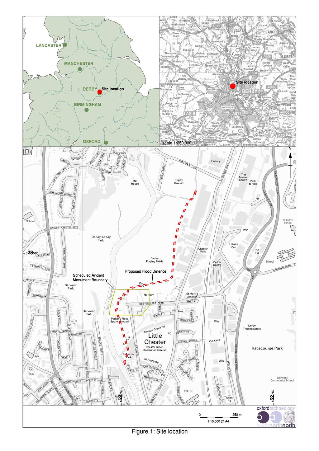
6 Little Chester Roman Fort, Derby, Derbyshire: Archaeological Evaluation Report 4 1. INTRODUCTION 1.1 CIRCUMSTANCES OF PROJECT The Environment Agency, in partnership with Derby City Council, is planning to develop new flood defences in Derby, which will involve the construction of new embankments along the River Derwent as it flows through Little Chester. Situated a short distance to the north of Derby city centre, Little Chester is the site of an important Roman fort (the site of which is afforded statutory designation as a Scheduled Monument), whilst Romano-British, Anglo-Saxon and medieval deposits have also been discovered in the area. The new flood defences will be located at Darley Playing Fields and Parker s Piece, and will also need to traverse the sits of the Roman fort, which is afforded statutory designation as a Scheduled Monument (SM No ) In order to understand and manage the archaeological risks associated with the proposed scheme, the Environment Agency, acting on the advice of English Heritage, commissioned Oxford Archaeology North (OA North) to undertake an archaeological evaluation of the defensive ditches encompassing the fort. The evaluation was intended to establish the precise location of the defensive ditches, particularly around the north-eastern corner of the fort. 1.2 SITE LOCATION The Roman fort at Little Chester, known as Derventio, lies in the north-eastern suburbs of Derby, some 1km from the modern city centre, on the flood plain east of the River Derwent (centred on NGR ). The floor of the river valley at Little Chester is approximately 1.5km wide, with the ground to the east rising gradually to Breadsall (Fig 1) The geology of the Derwent flood plain comprises gravel and sand, which are sealed by varying depths of loam and silt. The higher ground to the east and west comprises interleaved bands of Triassic Mudstone (Keuper Marl), whilst the hill on the west bank of the river, which is occupied by Strutt s Park, comprises bands of marl and sandstone capped by boulder clay (Mello 1876).

7 Little Chester Roman Fort, Derby, Derbyshire: Archaeological Evaluation Report 5 Plate 1: Aerial view of Little Chester, marking the projected footprint of the Roman fort
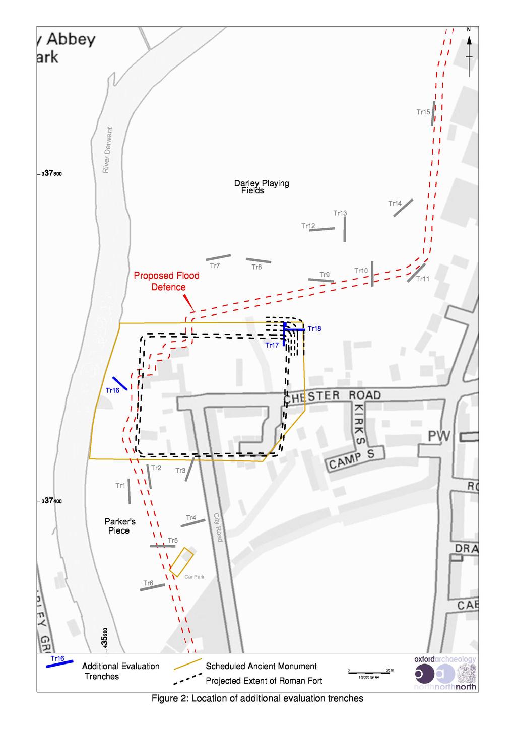
8 Little Chester Roman Fort, Derby, Derbyshire: Archaeological Evaluation Report 6 2. METHODOLOGY 2.1 TRIAL TRENCH EVALUATION In total, three trial trenches were excavated across the projected course of the Roman defences associated with Little Chester Roman fort (Fig 2). Each measured 30m long and 1.8m wide. Following the removal of the turf, the upper deposits in each trench were excavated using a 5-ton tracked machine fitted with a 1.8m wide toothless bucket. The machine operated under close archaeological supervision, down to the first archaeological deposits, whereupon all further excavation was completed manually. All spoil was scanned for artefacts Recording comprised a full description and preliminary classification of the deposits and materials revealed on OA North pro-forma sheets. The trenches were located with a Total Station Theodolite (TST) and tied into the Ordnance Survey grid. Hand-drawn plans were produced showing the contents of the trenches, with representative sections being drawn at a scale of 1:10 or 1:20 as appropriate. An indexed photographic record using monochrome and digital formats was maintained. 2.2 ARCHIVE The results of the archaeological evaluation will form the basis of a full archive to professional standards, in accordance with current English Heritage guidelines (English Heritage 1991; 2006). The project archive represents the indexing of all the data and material gathered during the course of the project OA North conforms to best practice in the preparation of project archives for long-term storage. The archive and the excavated material will be deposited with the Derby Museum and Art Gallery on The Strand, Derby. In addition, a copy of the archive can be made available for deposition in the National Archaeological Record. In addition, the Arts and Humanities Data Service (AHDS) online database project Online Access to index of Archaeological Investigations (OASIS) will be completed as part of the archiving phase of the project The material and paper archive generated from the evaluation will be transferred in accordance with the guidelines provided by Procedures for the Transfer of Archaeological Archives (2003). The Derby Museum and Art Gallery accession number is DBYMU
.")
9 Little Chester Roman Fort, Derby, Derbyshire: Archaeological Evaluation Report 7 3. HISTORICAL BACKGORUND 3.1 BACKGROUND The first Roman fort at Little Chester was established soon after AD 50 at Strutts Park, on the west bank of the River Derwent (Forrest 1967). This was one of a small number of Neronian forts in Derbyshire, which included Chesterfield (Ellis 1989), and possibly the Castle Hill Camp fortlet between Pentrich and South Wingfield (Kay 1961). However, the fort in Strutts Park had been replaced by AD 80 with a fort on the present site, which formed the focus for an associated settlement known as Derventio. In addition to its strategic location at an important crossing point of the River Derwent, the fort lay at the junction of several Roman roads, including Ryknield Street (Plate 2). This military highway ran from Gloucestershire to Templeborough in South Yorkshire, and provided Derventio with a direct link to the fort at Wall in Staffordshire and thus Watling Street, the principal route to North Wales. Another road headed south-east from Derventio to Sawley, on the River Trent, providing the fort with a link to the river for water traffic. A further road headed west, leading to Rocester, near Uttoxeter. Plate 2: The projected footprint of the Roman fort and the courses of the Roman roads, with the location of the evaluation trenches excavated in 2013
10 Little Chester Roman Fort, Derby, Derbyshire: Archaeological Evaluation Report The Roman fort at Little Chester was surveyed in 1724 by the pioneering antiquarian, William Stukeley, who noted a stone wall and surrounding ditch (Stukeley 1724, 50), although no trace of this survives in the modern landscape. A series of excavations carried out during the twentieth century concluded that the line of the defences surveyed by Stukeley overlay Flavian and early Antonine occupation on a different alignment. The excavated remains dating to this initial phase of extensive Roman occupation included timber buildings of probable military and civilian type, which seemingly spanned the late first- to mid-second century (Beswick and Fowkes 2002). An excavation in 1968 also revealed the foundations of a stone gate, suggesting the presence of an early defensive circuit. The eastern defences of the fort were found to comprise an Antonine clay rampart that had been cut back to allow the stone wall to be inserted in the late third century, with some remodelling of the defensive ditches (Brassington 1996). It was also noted that the eastern stone defences appeared to be of slightly different date from those on the west and south; the western and southern stone defences appeared to date from the mid-second century, although the excavation report does not refer to clay ramparts. The defensive circuit was found to comprise two outer ditches that seemingly enclosed an area of some seven acres. There is also evidence to suggest that a broad ditch, some 6.6m wide, was dug c 20m from the wall on the eastern side of the fort in the fourth century It seems that this defended area was given over to civilian settlement in the late second century, and some substantial buildings were erected within the defences, and also at the junction of the roads to the east (Brassington 1982a). These buildings included what may have been a mansio or a bath-house, the remains of which were discovered in 1924 during the construction of a school pavilion (Brassington 1982b) Roman burials have also been discovered at Little Chester, particularly along the edges of the main roads. Part of a Roman cemetery was also uncovered at Darley Grove, where graves containing skeletons, coins and other artefacts were discovered in By the early third century, much of the area was under cultivation and no longer in military occupation. Derventio was abandoned by the end of the fourth century, although evidence for post-roman settlement in the area is provided by cemetery close to the east gate of the fort, which is known to have been in use during the late fifth and early sixth centuries. Fragments of brooches, shields, a spearhead and a bowl, all dated to the sixth century, have been recovered from excavations in this cemetery. The focus of settlement shifted south to the modern city centre thereafter In the later Anglo-Saxon period, a rubble platform outside the rounded southeastern corner of the Roman wall may have supported a strengthening of the wall or the addition of a bastion. Thereafter, the ground was given over to agriculture until the eighteenth century, when the fort defences were destroyed and farm buildings erected on the site, to be succeeded in the nineteenth century by the railway embankment, now replaced by housing.
11 Little Chester Roman Fort, Derby, Derbyshire: Archaeological Evaluation Report 9 4. EVALUATION RESULTS 4.1 INTRODUCTION In total, three trenches were excavated across the projected line of the defensive ditches associated with the Roman fort at Little Chester (Fig 2). The following section provides a summary of the results obtained from the work. 4.2 TRENCH Trench 16 was placed on the nursery gardens nearest the river to the west of Derwent House, and was aligned north-west/south-east (Fig 2). The trench measured 22 x 1.8m, and was excavated to a maximum depth of 1.67m below the modern ground surface. The topsoil (1601) was removed mechanically to a depth of 0.30m, and modern deposit 1602 was similarly removed mechanically a further 0.70m The natural geology (1604) was identified at the northern end of the trench, and also at the southern end as orange-yellow sand. At the northern end of the trench, the natural geology was overlain by a bluish-grey clay deposit, 1614, which may represent the vestiges of a palaeo-channel. This deposit was overlain by mid- to light brown sandy silt alluvium (1603). Excavation of this layer yielded three fragments of animal bone A north/south-aligned ditch (1608), cut into natural geology 1604, was exposed at the southern end of the trench (Fig 3). The ditch was 3m wide, with a flat base and a maximum depth of only 0.52m, suggesting that it may not have been intended as a defensive features associated with the fort. The ditch was filled by a layer of compacted stone or gravel (1607), which appeared to have slumped into the ditch, and then overlain by homogeneous deposit that seemingly represented (1606) gradual silting. Neither of these layers yielded any artefacts, although they were almost certainly of Roman date The ditch fills were overlain by a layer of compact dark brown silt (1605). This was overlain by a layer of reddish-brown rubble (1609), which was in turn cut by the foundation trench (1613) for wall Wall 1611 was aligned east/west, and measured 0.40m wide (Fig 3). The fabric of the wall comprised roughly hewn stone and brick, suggesting that it was of a post-medieval date. This was corroborated by the range of artefacts recovered from the fill of the wall foundation trench (1612), which contained fragments of post-medieval pottery, clay pipe and glass Alluvial 1603 and the deposits south of wall 1611 were overlain by a light brown yellow alluvium (1616). This deposit was cut by a robber trench 1615 above wall This was filled by a dark brown clayey silt 1610 containing post-medieval pottery and glass. The deposits were sealed by a layer of modern disturbance 1602 containing concrete and metal measuring a depth of 0.70m. This was then sealed by topsoil 1601.


12 Little Chester Roman Fort, Derby, Derbyshire: Archaeological Evaluation Report 10 Plate 3: Trench 16 looking north-west Plate 4: North-east-facing section of ditch 1608
13 Little Chester Roman Fort, Derby, Derbyshire: Archaeological Evaluation Report TRENCH Trench 17 was aligned north/south across the nursery gardens to the south of Darley Playing Fields (Plate 5), and was targeted on the north-eastern corner of the defensive circuit associated with the Roman fort (Fig 2). Significant archaeological remains pertaining to the Roman period were encountered in this trench and, specifically, the remains of two substantial ditches The modern made ground and topsoil (1701) was removed mechanically to a depth of between 0.40m and 0.70m, and the subsoil (1702) was excavated mechanically for a further 0.40m. All excavation subsequently was carried out using exclusively manual techniques The natural geology was identified in the middle of the trench as orangeyellow clayey sand. The natural geology was cut by two large linear features, which almost certainly represented elements of the Roman fort s defences (Fig 4). In the central part of the trench was a V-shaped ditch (1705). It was aligned east/west, and measured 7.45m wide at the top and had a maximum depth of 2.30m deep (Fig 5). The primary fill of the ditch (1717) comprised a deposit of dark grey clayey silt, which was devoid of any finds Fill 1717 was overlain by deposit 1707, which seemingly represented the gradual silting of the ditch. Excavation of fill 1707 yielded 17 fragments of Roman pottery, and numerous fragments of animal bone. The maximum date range of the pottery spanned the late first to third centuries, although the group included a fragment of a South Gaulish samian bowl (Section below) that was characteristic of the first century, and generally out of production by c AD 85 (Webster 1996). In addition to the samian component, the group of pottery also included fragments amphora, frequently associated with a Roman military supply The upper fill of the ditch (1706) was very similar to made-ground deposit 1703, which may have slumped into the ditch once it had been abandoned. No artefacts or dating material was recovered from this upper fill The second large linear feature, exposed in the northern part of the trench (Fig 4), had evidently been re-cut of several occasions, indicating that it had been a long-lived feature. Two initial cuts lay parallel (1708 and 1715), but on a slightly different alignment to ditch 1705 (Fig 4). Ditch 1708 had a more rounded profile than ditch 1705, survived to a width of 2.4m, and had a maximum depth of 1.4m (Fig 5). It contained a single homogeneous fill (1710), which seemingly represented the gradual silting of the ditch over an extended period of time (Plate 6). Excavation of this fill yielded several fragments of Roman pottery, a low denomination Roman coin, a fragment of animal bone, and a fragment of ceramic building material. None of these artefacts can be dated with precision Ditch 1715 had been truncated by a later ditch (1713), and survived to a maximum width of 0.96m and depth of only 0.3m (Fig 5). It was filled by deposit 1716, which did not contain any artefacts.


14 Little Chester Roman Fort, Derby, Derbyshire: Archaeological Evaluation Report 12 Plate 5: General view along Trench 17, looking north Plate 6: East-facing section of ditch 1705
 seemingly represented a gradual silting of the ditch.")
15 Little Chester Roman Fort, Derby, Derbyshire: Archaeological Evaluation Report Ditch 1713 was slightly shallower than the earlier ditches. This had evidently persisted as a feature of the landscape for some time, as its fill (1714) seemingly represented a gradual silting of the ditch. However, excavation did not yield any artefacts to provide any indication for the abandonment and infilling of the ditch, although it was almost certainly of Roman origin Fill 1714 was cut by 1711, which represented the re-cutting of the ditch. The re-cut ditch was filled by two homogeneous deposits of silt (1712 and 1709). Fill 1712 contained several fragments of Roman pottery, with a probable second-century date, and a small fragment of ceramic building material The southern end of the trench appeared to have been raised artificailly. There were two layers of made ground: 1718, which represented the earlier deposit; and These layers were very mixed and well compacted, possibly suggesting a raised bank or platform, and potentially represent the base of the rampart for the Roman fort. However, no dating evidence was recovered from these deposits that could demonstrate these deposits to be of Roman origin. The made ground was overlaid by the modern material (1701), which included layers of hardcore and brick rubble (Plate 7). Plate 7: East-facing section of ditches 1708, 1711, 1713 and 1715
.")
16 Little Chester Roman Fort, Derby, Derbyshire: Archaeological Evaluation Report TRENCH Trench 18 was placed across the nursery gardens south of Darley Playing Fields, and was aligned east/west from approximately half way along Trench 17 (Fig 2). The topsoil (1801) was removed mechanically to a depth of 0.30m, and the subsoil (1802) was excavated mechanically to a depth of 0.80m (Plate 8). These deposits sealed the archaeological remains, which comprised significant Roman deposits. Plate 8: General view along Trench 18, looking west The natural geology (1803) was identified along the base of the excavated trench as yellow clayey sand. This was cut by three principal features: a shallow pit/posthole (1805); and two large ditches (1807 and 1813). The ditches were almost certainly associated with the defences of the Roman fort. Pit/posthole 1805 was identified at the western end of trench, and was filled by This had a diameter of 0.62m and survived to a maximum depth of 0.12m (Plate 9) Ditch 1807 was aligned north/south across Trench 18 (Fig 6). The ditch survived to a maximum width of 4.50m, and was 2.20m deep beneath the overburden. It seemingly had a similar profile to ditch 1705 in Trench 17, suggesting strongly that is was a Roman military defensive ditch of a contemporary date to 1705, although it flooded with water immediately upon excavation (Plate 10). Ditch 1807 was filled by a single homogenous deposit (1806), which seemingly derived from a gradual accumulation of silt. The fill contained several fragments of Roman pottery, with a date range spanning the later second and third centuries.


17 Little Chester Roman Fort, Derby, Derbyshire: Archaeological Evaluation Report 15 Plate 9: South-facing section of pit/posthole 1805 Plate 10: South-facing section of ditch 1807, showing ingress of groundwater
, followed by one large deep cut (1813).")
18 Little Chester Roman Fort, Derby, Derbyshire: Archaeological Evaluation Report The large ditch at the eastern end of Trench 18 comprised two earlier shallow cuts (1815 and 1817), followed by one large deep cut (1813). The earliest cut of the ditch (1817) was filled by an homogenous deposit of silt (1816). The feature was cut by ditch 1815, and only survived to a maximum depth of 0.20m, with a width of 0.80m (Fig 7); no finds were recovered from fill Ditch 1815 was filled by 1814, which seemingly derived from a gradual accumulation of silt. This ditch survived to a depth of 1.04m, and a width of 2.00m due to it being cut by ditch Fill 1814 was also devoid of artefacts Ditch 1813 had a maximum width of 6.5m, and cut through the fill (1814) of ditch 1815 (Fig 7). The primary fill comprised a thin layer of dark grey silty clay (1812), which contained organic deposits, indicative of a waterlogged environment. Above this deposit was bluish-grey silty clay (1811), which may have derived its colouration from long periods of saturation. This deposit also contained numerous large pieces of animal bone, and fragments of amphora, with a date range spanning the late first to third centuries Fill 1811 was sealed by light brownish-grey clayey silt (1810), which appeared to have washed in from the eastern edge of the ditch, suggesting that there had been some form of bank on that edge. Excavation yielded fragments of Roman pottery, with a date range spanning the later second to fourth centuries. Above this deposit was 1809, a dark brown clayey silt, which also appeared to have been washed into the ditch from the eastern edge. This deposit also contained a fourth-century coin, together with fragments of Roman pottery and animal bone. The final deposit of the ditch was a layer of mid-brown clayey silt (1808), representing the abandonment of the site. Plate 11: South-facing section of ditches 1813, 1815, and 1817
19 Little Chester Roman Fort, Derby, Derbyshire: Archaeological Evaluation Report THE FINDS 5.1 INTRODUCTION A small group of 221 fragments of artefacts and ecofacts were recovered during the evaluation trenching. All quantification is by fragment count, but in any subsequent period of analysis, pottery and other relevant material groups will also by quantified by weight, in order to conform with current standards. The broad division by material is presented below in Table 1, and an outline catalogue sorted by context, material, artefact category, and, where possible at this stage, by artefact type, is presented as Appendix 1. Most of the material appears well-stratified and will sustain some targeted analysis, having a limited potential to contribute significantly to dating the stratigraphic sequence All of the finds recovered from the evaluation were in fair to good condition, and many of the pottery fragments were of large size and unabraded, but no attempt was made at cross-context refits. At this stage in the analysis the few items of metalwork have not been x-rayed, but the single?silver coin survived in very good condition. Material Group Bone (animal) Ceramic Building Material Ceramic Vessel Copper Alloy Industrial Debris Fragment Count Percentage of Total Assemblage No Contexts Producing Finds Silver? Stone Mollusc Date Range Not closely dateable Romano-British Romano-British to medieval Romano-British Not closely dateable Fourth century Romano-British? Not closely dateable Total Table 1: Finds recovered from the evaluation trenches (quantified by material)
20 Little Chester Roman Fort, Derby, Derbyshire: Archaeological Evaluation Report ROMAN POTTERY A small group of 221 fragments of artefacts and ecofacts were recovered during the evaluation trenching. All quantification is by fragment count, but in any subsequent period of analysis, pottery and other relevant material groups will also by quantified by weight, in order to conform with current standards. The broad division by material is presented below in Table 1, and an outline catalogue sorted by context, material, artefact category, and, where possible at this stage, by artefact type, is presented as Appendix 1. Most of the material appears well-stratified and will sustain some targeted analysis, having a limited potential to contribute significantly to dating the stratigraphic sequence The small assemblage of pottery is almost entirely Romano-British in origin, with only one fragment of medieval pottery, recovered unstratified. The range of Roman pottery is very similar to that seen in other phases of the project, although Derbyshire ware, very well represented in the assemblages from earlier phases of the project and often very common in local assemblages (Tyers 1996), is only poorly represented in this group Spot-dating suggests focus on a later second and third century date for the group. Earlier pottery fabrics appear, especially amongst the samian (from ditch fills 1707, 1712, and 1810), with a fragment from a South Gaulish Dr 29 bowl, characteristic of the first century and generally out of production by c AD 85 (Webster 1996), from fill 1707 (Plate 12). Samian ware is relatively common within the group (ten fragments), making up 14% of the pottery present, and includes several decorated vessels, perhaps indicating a close connection with the military supply chain than seen in earlier assemblages, although this must remain speculation in such a small group. Other finewares are confined to Nene Valley-type colour-coated wares, of later second to fourth-century date, with fragments of at least one rouletted beaker noted The coarseware assemblage comprised a range of greywares, and orange oxidised wares, the former probably including Doncaster-type wares including both narrow-necked jars and wide-mouthed bowls, the latter comprises mainly Severn Valley wares, together these strongly suggest a late-second to thirdcentury date, although Black-burnished ware is surprisingly poorly represented for this date, with only two bowls, with a large fragment from ditch fill 1806 and an abraded fragment from ditch fill 1809 (Plate 13) There is only a single fragment of mortarium (from 1808). Its fabric is highly reminiscent of second-century Wroxeter mortaria (Tomber and Dore 1998, 178, pl 149b). 5.3 ROMAN BUILDING MATERIAL There is, in addition, a small amount of Roman ceramic building material, which includes small fragments of imbrices and tegulae, as well as smaller flat tiles. Stone building material is represented by a single dressed fragment of Roman masonry, recovered from Trench 16. Its curving surfaces suggest a roughly dressed column drum, perhaps intended to be stuccoed.


21 Little Chester Roman Fort, Derby, Derbyshire: Archaeological Evaluation Report 19 Plate 12: Fragments of samian recovered from ditch fill 1707 Plate 13: Roman greywares and Black-burnished ware recovered from ditch fill 1809
 remains unidentified (Plate 14).")
.")
22 Little Chester Roman Fort, Derby, Derbyshire: Archaeological Evaluation Report ROMAN COINS Two Roman coins were recovered from the evaluation. One, of copper alloy from ditch fill 1710 (Trench 17) remains unidentified (Plate 14). The other coin, extremely well-preserved, is from ditch fill 1809 (Trench 18), and has been identified as an issue of Crispus, the eldest son of Constantine the Great, and can be dated AD (Plate 15). Plate 14: Unidentified copper-alloy coin recovered from ditch fill 1710 Plate 15: Silver coin recovered from ditch fill 1809
23 Little Chester Roman Fort, Derby, Derbyshire: Archaeological Evaluation Report ANIMAL BONE Although a considerable amount of animal bone was recovered from the evaluation, most derived from a single cow skull and vertebrae found together in ditch fill 1811 (Trench 18), and perhaps representing a deliberate deposit, and a cow lower mandible and other chewed bones from ditch fill CHARRED AND WATERLOGGED PLANT REMAINS ASSESSMENT Quantification: three environmental bulk samples, each 10 litres in volume, were taken from two features for the assessment of charred and waterlogged plant remains (Table 2). The features sampled were ditch 1813, and small pit/posthole The samples were hand-floated and the flots collected on a 250 micron mesh and air-dried. The flots were scanned with a Wild M3Z stereo-microscope and the plant material and charcoal quantified and provisionally identified. The plant remains were scored on a scale of abundance of 1-5, where 1 is rare and 5 is abundant (>100 items). Context Number Sample Number Context Type Volume of Processed Sample (litres) Top fill of ditch Intermediate fill of ditch Primary fill of ditch Fill of small pit/posthole Table 2: Environmental bulk sample assessed for plant remains Results and interpretation: the results of the palaeo-environmental assessment are summarised in Table 3. Two of the contexts (fills 1809 and 1810) contained charred cereal grains, wheat (Triticum sp). The small pit/posthole contained a charred corn marigold (Chrysanthemum segetum) Waterlogged plant remains were recorded in the primary fill of the ditch 1813, and there was some vivianite staining. Plant remains included common sorrel (Rumex acetosa), common nettle (Urtica dioica), common chickweed (Stellaria media), creeping buttercup (Ranunculus repens) and dead nettle (Lamiaceae). Curiously, the primary ditch fill also contained in high quantities poison ivy (Rhus radicans), a poisonous plant from the eastern USA Potential: this rapid assessment of the plant remains has demonstrated that the potential for the survival of plant remains in the deposits from the site is low. The primary ditch fill plant remains had vivianite staining, which can indicate cess deposits, but there were no plant remains that were indicative of food plants. The only seed of any quantity was poison ivy (Rhus radicans), which is very unusual in a Roman context, and may suggest that the ditch fill had been subject to some disturbance that enabled contamination with more recent plant remains. However, there is some material that may be suitable for scientific dating, including the charred cereal grains recovered from ditch fills 1809 and 1810.
24 Little Chester Roman Fort, Derby, Derbyshire: Archaeological Evaluation Report 22 Sample No Context No Feature Flot Volume (ml) Flot Description Plant Remains Potential for Analysis Upper ditch fill Charcoal >2mm (++), Fish scales +, Coal/clinker ++ CPR (1) Cerealia indet WPR (1)Rumex acetosa, Cirsium Low Intermed iate ditch fill Charcoal >2mm (+), Calcined bone (+), Bone (+) CPR (1) Cerealia indet Low Primary ditch fill Charcoal >2mm (+), Coal/clinker (+++), Bone (+) Vivianite (+) staining WPR (4) Rumex acetosa, Urtica dioica, Stellaria media, Lamiacea, Ranunculus repens, Rhus radicans Moderate Fill of posthole Charcoal >2mm (+) CPR (1) Chrysanthemum Segetum Low CPR = charred plant remains WPR = waterlogged plant remains HAVM = heat affected vesicular material Table 3: Charred and waterlogged plant remains from the evaluation Scale 1= present (up to 5 items), 2= frequent (5-25), 3= common (25-50), 4= abundant (50-100), 5= (>100) + is present ++ is abundant
25 Little Chester Roman Fort, Derby, Derbyshire: Archaeological Evaluation Report DISCUSSION 6.1 INTRODUCTION The archaeological evaluation has provided an important opportunity to establish the investigate the defensive circuit associated with the Roman fort of Derventio, and add fresh information as to their location and chronological development. Whilst the footprint of the Roman fort has been subject to numerous archaeological investigations previously, the precise route of the defensive ditches around the north-eastern corner of the fort remained uncertain. The current project has enabled a better understanding of the route of the defensive ditches within this part of the Scheduled Monument, and has demonstrated that they survive largely intact, representing an important archaeological resource. The evaluation has also demonstrated that Roman remains immediately to the west of the Roman fort have been subject to some disturbance, and whilst important remains do survive in-situ, later activity has evidently had some negative impact on buried remains to the west of the fort. 6.2 THE ROMAN DITCHES The remains of ditches associated with the Roman fort were identified in all of the evaluation trenches. The ditch exposed in Trench 16, situated to the west of the Roman fort, had been subject to some disturbance as a result of postmedieval activity. However, the flat-bottomed form of this ditch is inconsistent with the usual character of a Roman fort ditch, suggesting that it may have lay slightly beyond the defensive circuit A series of ditches were exposed in both of the trenches placed across the projected north-eastern corner of the Scheduled Monument. Excavations carried out in 1968 concluded that the defensive circuit comprised two outer ditches, with some suggestion of a third ditch that was added to the defensive system in the fourth century (Brassington 1996). The present evaluation has similarly identified a series of three ditches to the north-east of the fort. It is probable that ditch 1705 (Trench 17) represented the remains of the defensive ditch closest to the fort, and the excavated section lay immediately before the course of the ditch turned through a right angle to continue along the eastern side of the fort (Fig 8). This would certainly explain the slight mis-alignment with the adjacent ditch (1713) exposed in the same trench Ditch 1713 seemingly represented the second ditch from the fort, and had evidently been remodelled slightly; it may originally have comprised two narrower ditches that were expanded to create a single larger ditch subsequently. The date range of artefacts recovered from the fill of ditch 1713 imply that this remodelling had been completed prior to the third century. It seems possible that the north-south-aligned continuation of this ditch along the eastern side of the Roman fort was represented by ditch 1807 (Fig 8), although this section of the ditch did not appear to have been remodelled. Nevertheless, artefacts recovered from the fill of ditch 1807 had a similar date range to those from ditch 1713.
26 Little Chester Roman Fort, Derby, Derbyshire: Archaeological Evaluation Report The ditch exposed at the eastern end of Trench 18 (1813) may represent the outer defensive ditch associated with the Roman fort, and is likely to correspond with the third ditch that identified during the excavation in 1968 (Brassington 1996). However, ditch 1813 evidently derived from a remodelling of earlier ditches, and thus whilst the recovery of fourth-century material from its fill indicate that it persisted as a feature in the landscape though to the end of the Roman period, it is likely to have been an earlier feature, and potentially contemporary with the ditches excavated in Trench IMPACT The development of new flood defences may necessitate considerable groundmoving works, which could have a substantial impact on the sub-surface archaeological resource. An appropriate scheme of further archaeological investigation in advance of development will therefore be required to mitigate the ultimate loss of the buried remains. The details of any further archaeological work required in advance of development should be devised in consultation with the Derbyshire County Council Archaeological Services and English Heritage. However, the results obtained from the evaluation trenching indicate that the impact on the sub-surface archaeological resource may be less substantial along the western side of the Roman fort, where buried remains of archaeological significance have been subject to some disturbance previously.
27 Little Chester Roman Fort, Derby, Derbyshire: Archaeological Evaluation Report CURATION AND CONSERVATION 7.1 RECIPIENT MUSEUM The Derby Museum and Art Gallery has been nominated as having the capacity to co-ordinate the deposition of the finds and the paper and electronic archive. Paper and digital copies of issued reports will be deposited with the museum. The material generated from the excavation has been allocated a unique archive accession number (DBYMU ). 7.2 CONSERVATION Most of the assemblage is well-preserved and in good condition, and thus the conservation requirement is low. Only the copper-alloy Roman coin from Trench 17 is likely to require cleaning, principally in order to facilitate identification. 7.3 STORAGE The complete project archive, which will include written records, plans, black and white, digital plans and photographs, artefacts, ecofacts and sieved residues, will be prepared following the guidelines set out in Environmental standards for the permanent storage of excavated material from archaeological sites (UKIC 1984, Conservation Guidelines 3) and Guidelines for the preparation of excavation archives for long-term storage (Walker 1990), prior to deposition The digital data will be stored temporarily on the server at OA North, which is backed up on a daily basis. For long-term storage of the digital data, CDs will be used, the content including the reports, plans, scanned images and digital photographs. Each CD will be fully indexed and accompanied by the relevant metadata for provenance. The digital record should ideally be duplicated as a paper record for long-term archiving, including comprehensive printouts of photographs and survey plots, labelled and summarised All dry and stable finds will be packed according to the museum s specifications, in either acid-free cardboard boxes, or in airtight plastic boxes for unstable material. Each box will have a list of its contents and will in general contain only one type of material, such as pottery or bone. 7.4 PACKAGING The assemblage is currently well-packaged and will require no further packaging. Box lists derived from the site database have been compiled and will be updated when the identification of objects is complete. The paper records will be presented in either ring binders or in acid-free storage, fully indexed, and with the contents labelled.
28 Little Chester Roman Fort, Derby, Derbyshire: Archaeological Evaluation Report 26 BIBLIOGRAPHY SECONDARY SOURCES Armstrong, P, and Armstrong, SJ, 1987, The Clay Roof Tile, in Armstrong, P and Ayers, B, Excavations in High Street and Blackfriargate, Hull Old Town Report Series No 5, Armstrong, P, 1991, The Clay Roof Tile, in Armstrong, P, Tomlinson, D, and Evans, DH, Excavations at Lurk Lane, , Sheffield, Barrett, D, 2000a An Archaeological Resource Assessment of the Later Bronze and Iron Ages (The First Millennium BC) in Derbyshire. East Midlands Archaeological Research Framework: Barrett, D, 2000b An Archaeological Resource Assessment of Anglo-Saxon Derbyshire. East Midlands Archaeological Research Framework: Barrett, D, 2000c An Archaeological Resource Assessment of Medieval Derbyshire, East Midlands Archaeological Research Framework: Beswick, P, and Fowkes, D, 2002 Excavations on the South-Eastern Defences and Extramural Settlement of Little Chester, Derby, , Derbyshire Archaeological Journal, 122, Boesneck, J, 1969 Osteological Differences between Sheep (Ovis aries Linne) and Goat (Capra hircus Linne), in D Brothwell and E Higgs (eds), Science and Archaeology, 2, London, Brassington, M, 1967 Roman material recovered from Little Chester, Derby, Derbyshire Archaeological Journal, 87, Brassington, M, 1971 A Trajanic kiln-complex near Little Chester, Derby, Antiquaries Journal, 51, Brassington, M, 1981 The Roman Roads of Derby, Derbyshire Archaeological Journal, 101, Brassington, M, 1982a Exploratory Excavations at Little Chester, Derby, Derbyshire Archaeological Journal, 102, Brassington, M, 1982b The Excavation of the Hypocaust on Parker's Piece, Little Chester, Derby, , Derbyshire Archaeological Journal, 102, 84-6 Brassington, M, 1993 Little Chester, Derby: The 1926 Excavations, Derbyshire Archaeological Journal, 113, 21-44
29 Little Chester Roman Fort, Derby, Derbyshire: Archaeological Evaluation Report 27 Brassington, M, 1996 The Roman fort at Little Chester, Derby: The East Wall and Rampart, , Derbyshire Archaeological Journal, 116, Cooper, N (ed), 2006 The Archaeology of the East Midlands: An Archaeological Resource Assessment and Research Agenda, Leicester Archaeol Mono, 13, Leicester Crooks, K, Porter, S, Morriss, R, and Boucher, A, 2003 Derby Magistrates Court, St Mary s Gate, Derby: Excavation and Building Recording, unpubl rep Ellis, P, 1989 Roman Chesterfield. Excavations by Terry Courtney , Derbyshire Archaeological Journal, 109, English Heritage, 1991 Management of Archaeological Projects, 2 nd edn, London English Heritage, 1997 Archaeology Division Research Agenda (draft), unpubl doc English Heritage, 2005 Discovering the Past, Shaping the Future, London English Heritage, 2006 Management of Research Projects in the Historic Environment (MoRPHE), London English Heritage, 2011 The National Heritage Protection Plan, London Hall, RA, and Coppack, G, 1972 Excavations at Full Street, Derby, Derbyshire Archaeol J, 92, James, S, and Millett, M (eds), 2001 Britions and Romans: Advancing an Archaeological Agenda, CBA Res Rep, 125, York Kay, SO, 1961 Some Pottery Fragments from the Roman camp at Pentrich, Derbyshire Archaeological Journal, 81, Kratochvil, Z, 1969 Species Criteria on the Distal Section of the Tibia in Ovis Ammon F. Aries and Capra Aegarus F. Hircus L. in Acta Veterinaria (Brno), 389, Lewis, C, 2006 An Archaeological Resource Assessment and Research Agenda for the Medieval Period in the East Midlands, in Cooper 2006, Mackreth, DF, 2011 Brooches in Late Iron Age and Roman Britain (2 vols), Oxford Mello, JM, 1876 Hand-book to the Geology of Derbyshire, London Moorhouse, S, 1981 The medieval pottery industry and its markets, in D W Crossley (ed), Medieval industry, CBA Res Rep, 40, London, Mould, Q, 2011 Domestic Life, in L Allason Jones (ed), Artefacts in Roman Britain: their Purpose and Use, Cambridge, Myers, A, 2000 An Archaeological Resource Assessment of Roman Derbyshire: East Midlands Archaeological Research Framework,
30 Little Chester Roman Fort, Derby, Derbyshire: Archaeological Evaluation Report 28 OA North, 2013 Former Prince s Supermarket, Bold Lane, Derby: Post-excavation Assessment, unpubl rep Prummel, W, and Frisch, H-J, 1986 A Guide for the Distinction of Species, Sex and Body Side in Bones of Sheep and Goat, J Archaeol Sci, 13, Rigby, V, 2001 Relief-decorated pottery, in PC Buckland, KF Hartley, and V Rigby, The Roman Pottery Kilns at Rossington Bridge. Excavations , Journal of Roman Pottery Studies, 9, Sparey-Green, C, 2002 Excavations on the South-eastern Defences and Extramural Settlement of Little Chester, Derby , Derbyshire Archaeological Journal, 122 Stukeley, W, 1724 Itinerarium Curiosum, London Taylor, J, 2006 The Roman Period, in N Cooper 2006, Todd, M, 1967 The Roman Site at Little Chester, Derby: Excavations in 1966, Derbyshire Archaeological Journal, 87, Tomber, R, and Dore, J, 1998 The National Roman Fabric Reference Collection. A Handbook, London Tyers, P, 1996 Roman Pottery in Britain, London Walker, K, 1990 Guidelines for the Preparation of Archaeological Archives for Long Term Storage, UKIC Archaeology Section, London Webster, G, 1961 An Excavation on the Roman Site at Little Chester, Derby, Derbyshire Archaeological Journal, 81, Webster, P, 1996 Roman Samian Pottery in Britain, CBA Practical Handbook in Archaeology, 13, York
31 Little Chester Roman Fort, Derby, Derbyshire: Archaeological Evaluation Report 29 APPENDIX 1: SUMMARY FINDS CATALOGUE Context Trench 16 OR no Qty Material Category Description Dating Bone animal Not closely dateable Context Trench 17 OR no Qty Material Category Description Dating Bone animal Not closely dateable Ceramic vessel Samian, including decorated forms Dr29, Dr 37, cup Dr Ceramic vessel Coarsewares including Derbyshire ware and greyware Later first to second century Ceramic vessel Amphora, Dressel 20. Late first to mid-third Ceramic vessel Samian, plain form Probably second century Ceramic building material Undiagnostic Romano-British Bone animal Not closely dateable Ceramic vessel Amphora, undiagnostic coarseware Ceramic building material Copper alloy coin Ceramic building material Undiagnostic Low denomination Roman coin Undiagnostic Romano-British Romano-British Romano-British Romano-British Ceramic vessel Samian, plain forms Probably second century Ceramic vessel Whiteware Romano-British
32 Little Chester Roman Fort, Derby, Derbyshire: Archaeological Evaluation Report 30 Context Trench 18 OR no Qty Material Category Description Dating Ceramic vessel Whiteware, orange-oxidised fabric Romano-British Bone animal Not closely dateable Ceramic vessel Derbyshire ware, Black Burnished ware, greyware, orange oxidised ware Ceramic building material Undiagnostic Later secondthird century Romano-British Ind debris Small undiagnostic fragments Not closely dateable Bone animal Not closely dateable Ceramic vessel Greyware, undiagnostic Romano-British Ceramic vessel Mortarium, orange fabric Second century Ceramic vessel Greyware Ceramic building material Undiagnostic Romano-British Ceramic vessel Oxidised ware, undiagnostic Romano-British Cone animal Not closely dateable Ceramic building material Undiagnostic Romano-British Ceramic vessel Nene Valley ware Later second to fourth century Ceramic vessel Greyware Later secondthird/fourth century Ceramic vessel Nene Valley ware, Severn Valley ware Later secondthird/fourth century Ceramic vessel Amphora First to third century Ceramic building material Copper alloy Undiagnostic Romano-British sheet Small fragment of sheet. Not closely dateable Silver? coin Crispus AD Bone animal Not closely dateable Ceramic vessel Nene Valley ware, whiteware Late second to fourth century
33 Little Chester Roman Fort, Derby, Derbyshire: Archaeological Evaluation Report 31 Context OR no Qty Material Category Description Dating Ceramic vessel Samian Probably second century Marine mollusc oyster Not closely dateable Bone animal Not closely dateable Ceramic vessel Amphora First to third century unstrat Ceramic vessel Includes one medieval sherd. Romano-British on unstrat Ind debris Small fragments Not closely dateable unstrat 1 Stone building material Well-dressed, rounded fragment of building stone, possibly a crude column drum? Romano-British?
34 Little Chester Roman Fort, Derby, Derbyshire: Archaeological Evaluation Report 32 ILLUSTRATIONS FIGURES Figure 1: Figure 2: Site location Location of additional evaluation trenches Figure 3: Plan of Trench 16 Figure 4: Plan of Trench 17 Figure 5: Trench 17 sections Figure 6: Plan of Trench 18 Figure 7: Figure 8: Trench 18 sections Plan of projected ditches
35
36

37
38
39
40

41
An archaeological evaluation at 16 Seaview Road, Brightlingsea, Essex February 2004
 An archaeological evaluation at 16 Seaview Road, Brightlingsea, Essex February 2004 report prepared by Kate Orr on behalf of Highfield Homes NGR: TM 086 174 (c) CAT project ref.: 04/2b ECC HAMP group site
An archaeological evaluation in the playground of Colchester Royal Grammar School, Lexden Road, Colchester, Essex
 An archaeological evaluation in the playground of Colchester Royal Grammar School, Lexden Road, Colchester, Essex February 2002 on behalf of Roff Marsh Partnership CAT project code: 02/2c Colchester Museum
ARCHAEOLOGICAL EVALUATION AT BRIGHTON POLYTECHNIC, NORTH FIELD SITE, VARLEY HALLS, COLDEAN LANE, BRIGHTON. by Ian Greig MA AIFA.
 ARCHAEOLOGICAL EVALUATION AT BRIGHTON POLYTECHNIC, NORTH FIELD SITE, VARLEY HALLS, COLDEAN LANE, BRIGHTON by Ian Greig MA AIFA May 1992 South Eastern Archaeological Services Field Archaeology Unit White
New Composting Centre, Ashgrove Farm, Ardley, Oxfordshire
 New Composting Centre, Ashgrove Farm, Ardley, Oxfordshire An Archaeological Watching Brief For Agrivert Limited by Andrew Weale Thames Valley Archaeological Services Ltd Site Code AFA 09/20 August 2009
3. The new face of Bronze Age pottery Jacinta Kiely and Bruce Sutton
 3. The new face of Bronze Age pottery Jacinta Kiely and Bruce Sutton Illus. 1 Location map of Early Bronze Age site at Mitchelstown, Co. Cork (based on the Ordnance Survey Ireland map) A previously unknown
2 Saxon Way, Old Windsor, Berkshire
 2 Saxon Way, Old Windsor, Berkshire An Archaeological Watching Brief For Mrs J. McGillicuddy by Pamela Jenkins Thames Valley Archaeological Services Ltd Site Code SWO 05/67 August 2005 Summary Site name:
39, Walnut Tree Lane, Sudbury (SUY 073) Planning Application No. B/04/02019/FUL Archaeological Monitoring Report No. 2005/112 OASIS ID no.
 Planning Application No. B/04/02019/FUL Archaeological Monitoring Report No. 2005/112 OASIS ID no.") 39, Walnut Tree Lane, Sudbury (SUY 073) Planning Application No. B/04/02019/FUL Archaeological Monitoring Report No. 2005/112 OASIS ID no. 9273 Summary Sudbury, 39, Walnut Tree Lane, Sudbury (TL/869412;
39, Walnut Tree Lane, Sudbury (SUY 073) Planning Application No. B/04/02019/FUL Archaeological Monitoring Report No. 2005/112 OASIS ID no. 9273 Summary Sudbury, 39, Walnut Tree Lane, Sudbury (TL/869412;
Colchester Archaeological Trust Ltd. A Fieldwalking Survey at Birch, Colchester for ARC Southern Ltd
 Colchester Archaeological Trust Ltd A Fieldwalking Survey at Birch, Colchester for ARC Southern Ltd November 1997 CONTENTS page Summary... 1 Background... 1 Methods... 1 Retrieval Policy... 2 Conditions...
An archaeological evaluation at the Blackwater Hotel, Church Road, West Mersea, Colchester, Essex March 2003
 An archaeological evaluation at the Blackwater Hotel, Church Road, West Mersea, Colchester, Essex report prepared by Laura Pooley on behalf of Dolphin Developments (U.K) Ltd NGR: TM 0082 1259 CAT project
Grim s Ditch, Starveall Farm, Wootton, Woodstock, Oxfordshire
 Grim s Ditch, Starveall Farm, Wootton, Woodstock, Oxfordshire An Archaeological Recording Action For Empire Homes by Steve Ford Thames Valley Archaeological Services Ltd Site Code SFW06/118 November 2006
An archaeological watching brief and recording at Brightlingsea Quarry, Moverons Lane, Brightlingsea, Essex October 2003
 An archaeological watching brief and recording at Brightlingsea Quarry, Moverons Lane, Brightlingsea, Essex commissioned by Mineral Services Ltd on behalf of Alresford Sand & Ballast Co Ltd report prepared
An archaeological evaluation at the Lexden Wood Golf Club (Westhouse Farm), Lexden, Colchester, Essex
, Lexden, Colchester, Essex") An archaeological evaluation at the Lexden Wood Golf Club (Westhouse Farm), Lexden, Colchester, Essex January 2000 Archive report on behalf of Lexden Wood Golf Club Colchester Archaeological Trust 12 Lexden
An archaeological evaluation at the Lexden Wood Golf Club (Westhouse Farm), Lexden, Colchester, Essex January 2000 Archive report on behalf of Lexden Wood Golf Club Colchester Archaeological Trust 12 Lexden
Test-Pit 3: 31 Park Street (SK )
") -Pit 3: 31 Park Street (SK 40732 03178) -Pit 3 was excavated in a flower bed in the rear garden of 31 Park Street, on the northern side of the street and west of an alleyway leading to St Peter s Church,
-Pit 3: 31 Park Street (SK 40732 03178) -Pit 3 was excavated in a flower bed in the rear garden of 31 Park Street, on the northern side of the street and west of an alleyway leading to St Peter s Church,
Greater London GREATER LONDON 3/606 (E ) TQ
 TQ") GREATER LONDON City of London 3/606 (E.01.6024) TQ 30358150 1 PLOUGH PLACE, CITY OF LONDON An Archaeological Watching Brief at 1 Plough Place, City of London, London EC4 Butler, J London : Pre-Construct
GREATER LONDON City of London 3/606 (E.01.6024) TQ 30358150 1 PLOUGH PLACE, CITY OF LONDON An Archaeological Watching Brief at 1 Plough Place, City of London, London EC4 Butler, J London : Pre-Construct
Former Whitbread Training Centre Site, Abbey Street, Faversham, Kent Interim Archaeological Report Phase 1 November 2009
 Former Whitbread Training Centre Site, Abbey Street, Faversham, Kent Interim Archaeological Report Phase 1 November 2009 SWAT. Archaeology Swale and Thames Archaeological Survey Company School Farm Oast,
Archaeological. Monitoring & Recording Report. Fulbourn Primary School, Cambridgeshire. Archaeological Monitoring & Recording Report.
 Fulbourn Primary School, Cambridgeshire Archaeological Monitoring & Recording Report October 2014 Client: Cambridgeshire County Council OA East Report No: 1689 OASIS No: oxfordar3-192890 NGR: TL 5190 5613
Essex Historic Environment Record/ Essex Archaeology and History
 Essex Historic Environment Record/ Essex Archaeology and History CAT Report 578 Summary sheet Address: Kingswode Hoe School, Sussex Road, Colchester, Essex Parish: Colchester NGR: TL 9835 2528 Type of
Fort Arbeia and the Roman Empire in Britain 2012 FIELD REPORT
 Fort Arbeia and the Roman Empire in Britain 2012 FIELD REPORT Background Information Lead PI: Paul Bidwell Report completed by: Paul Bidwell Period Covered by this report: 17 June to 25 August 2012 Date
Fieldwalking at Cottam 1994 (COT94F)
") Fieldwalking at Cottam 1994 (COT94F) Tony Austin & Elizabeth Jelley (19 Jan 29) 1. Introduction During the winter of 1994 students from the Department of Archaeology at the University of York undertook
Fieldwalking at Cottam 1994 (COT94F) Tony Austin & Elizabeth Jelley (19 Jan 29) 1. Introduction During the winter of 1994 students from the Department of Archaeology at the University of York undertook
7. Prehistoric features and an early medieval enclosure at Coonagh West, Co. Limerick Kate Taylor
 7. Prehistoric features and an early medieval enclosure at Coonagh West, Co. Limerick Kate Taylor Illus. 1 Location of the site in Coonagh West, Co. Limerick (based on the Ordnance Survey Ireland map)
ARCHAEOLOGICAL MONITORING REPORT
 ARCHAEOLOGICAL MONITORING REPORT SCCAS REPORT No. 2009/324 Thorington Hall, Stoke by Nayland SBN 087 HER Information Date of Fieldwork: November 2009 - January 2010 Grid Reference: TM 0131 3546 Funding
SALVAGE EXCAVATIONS AT OLD DOWN FARM, EAST MEON
 Proc. Hants. Field Club Archaeol. Soc. 36, 1980, 153-160. 153 SALVAGE EXCAVATIONS AT OLD DOWN FARM, EAST MEON By RICHARD WHINNEY AND GEORGE WALKER INTRODUCTION The site was discovered by chance in December
Church of St Peter and St Paul, Great Missenden, Buckinghamshire
 Church of St Peter and St Paul, Great Missenden, Buckinghamshire An Archaeological Watching Brief for the Parish of Great Missenden by Andrew Taylor Thames Valley Archaeological Services Ltd Site Code
A Sense of Place Tor Enclosures
 A Sense of Place Tor Enclosures Tor enclosures were built around six thousand years ago (4000 BC) in the early part of the Neolithic period. They are large enclosures defined by stony banks sited on hilltops
Cetamura Results
 Cetamura 2000 2006 Results A major project during the years 2000-2006 was the excavation to bedrock of two large and deep units located on an escarpment between Zone I and Zone II (fig. 1 and fig. 2);
Archaeological evaluation at the Onley Arms, The Street, Stisted, Essex
 Archaeological evaluation at the Onley Arms, The Street, Stisted, Essex November 2014 report by Pip Parmenter and Adam Wightman with a contribution from Stephen Benfield and illustrations by Emma Holloway
An archaeological watching brief on one section of an Anglian Water main Spring Lane, Lexden, Colchester
 An archaeological watching brief on one section of an Anglian Water main Spring Lane, Lexden, Colchester April-September 2001 on behalf of Breheny Contractors CAT project ref.: 01/4D Colchester Museum
Monitoring Report No. 99
 Monitoring Report No. 99 Enniskillen Castle Co. Fermanagh AE/06/23 Cormac McSparron Site Specific Information Site Name: Townland: Enniskillen Castle Enniskillen SMR No: FER 211:039 Grid Ref: County: Excavation
An archaeological evaluation by trial-trenching at Playgolf, Bakers Lane, Westhouse Farm, Colchester, Essex
 An archaeological evaluation by trial-trenching at Playgolf, Bakers Lane, Westhouse Farm, Colchester, Essex commissioned by Mr Stephen Belchem on behalf of ADP Ltd. report prepared by Chris Lister Planning
Monitoring Report No Sacred Heart Church Aghamore Boho Co. Fermanagh AE/10/116E. Brian Sloan L/2009/1262/F
 Monitoring Report No. 202 Sacred Heart Church Aghamore Boho Co. Fermanagh AE/10/116E Brian Sloan L/2009/1262/F Site Specific Information Site Address: Sacred Heart Church, Aghamore, Boho, Co. Fermanagh
Wantage County Primary School, Garston Lane, Wantage, Oxfordshire
 Wantage County Primary School, Garston Lane, Wantage, Oxfordshire An Archaeological Evaluation for Oxfordshire County Council by Erlend Hindmarch Thames Valley Archaeological Services Ltd Site Code GLW
Silwood Farm, Silwood Park, Cheapside Road, Ascot, Berkshire
 Silwood Farm, Silwood Park, Cheapside Road, Ascot, Berkshire An Archaeological Watching Brief For Imperial College London by Tim Dawson Thames Valley Archaeological Services Ltd Site Code SFA 09/10 April
Greater London Region GREATER LONDON 3/567 (E.01.K099) TQ BERMONDSEY STREET AND GIFCO BUILDING AND CAR PARK
 TQ BERMONDSEY STREET AND GIFCO BUILDING AND CAR PARK") GREATER LONDON 3/567 (E.01.K099) TQ 33307955 156-170 BERMONDSEY STREET AND GIFCO BUILDING AND CAR PARK Assessment of an Archaeological Excavation at 156-170 Bermondsey Street and GIFCO Building and Car
GREATER LONDON 3/567 (E.01.K099) TQ 33307955 156-170 BERMONDSEY STREET AND GIFCO BUILDING AND CAR PARK Assessment of an Archaeological Excavation at 156-170 Bermondsey Street and GIFCO Building and Car
Cambridge Archaeology Field Group. Fieldwalking on the Childerley Estate Cambridgeshire
 Cambridge Archaeology Field Group Fieldwalking on the Childerley Estate Cambridgeshire 2009 to 2014 Summary Fieldwalking on the Childerley estate of Martin Jenkins and Family has revealed, up to March
Moray Archaeology For All Project
 School children learning how to identify finds. (Above) A flint tool found at Clarkly Hill. Copyright: Leanne Demay Moray Archaeology For All Project ational Museums Scotland have been excavating in Moray
FURTHER MIDDLE SAXON EVIDENCE AT COOK STREET, SOUTHAMPTON (SOU 567)
") Roc. Hampshire Field Club Archaeol. Soc 52,1997, 77-87 (Hampshire Studies 1997) FURTHER MIDDLE SAXON EVIDENCE AT COOK STREET, SOUTHAMPTON (SOU 567) By M F GARNER andj VINCENT with a contribution byjacqueline
Roc. Hampshire Field Club Archaeol. Soc 52,1997, 77-87 (Hampshire Studies 1997) FURTHER MIDDLE SAXON EVIDENCE AT COOK STREET, SOUTHAMPTON (SOU 567) By M F GARNER andj VINCENT with a contribution byjacqueline
Suburban life in Roman Durnovaria
 Suburban life in Roman Durnovaria Additional specialist report Finds Ceramic building material By Kayt Brown Ceramic building material (CBM) Kayt Brown A total of 16420 fragments (926743g) of Roman ceramic
An archaeological watching brief at Sheepen, Colchester, Essex November-December 2003
 An archaeological watching brief at Sheepen, Colchester, Essex November-December 2003 report prepared by Ben Holloway on behalf of Colchester Borough Council CAT project ref.: 03/11c Colchester Museums
Lanton Lithic Assessment
 Lanton Lithic Assessment Dr Clive Waddington ARS Ltd The section headings in the following assessment report refer to those in the Management of Archaeological Projects (HBMC 1991), Appendix 4. 1. FACTUAL
NOTE A THIRD CENTURY ROMAN BURIAL FROM MANOR FARM, HURSTBOURNE PRIORS. by. David Allen with contributions by Sue Anderson and Brenda Dickinson
 Proc. Hampsh. Field Club Archaeol. Soc. 47, 1991, 253-257 NOTE A THIRD CENTURY ROMAN BURIAL FROM MANOR FARM, HURSTBOURNE PRIORS Abstract by. David Allen with contributions by Sue Anderson and Brenda Dickinson
Cambridge Archaeology Field Group. Fieldwalking on the Childerley Estate, Cambridgeshire. Autumn 2014 to Spring Third interim report
 Cambridge Archaeology Field Group Fieldwalking on the Childerley Estate, Cambridgeshire Autumn 2014 to Spring 2015 Third interim report Summary Field walking on the Childerley estate of Martin Jenkins
Chapel House Wood Landscape Project. Interim Report 2013
 Chapel House Wood Landscape Project Interim Report 2013 Chapel House Wood Landscape Project Interim Report 2013 The annual Dales Heritage Field School was held at Chapel House Wood again this year, and
Former Filling Station, High Street, Dorchester-on-Thames, Oxfordshire
 Former Filling Station, High Street, Dorchester-on-Thames, Oxfordshire An Archaeological Evaluation for Country Visions OK Limited by Sarah Coles Thames Valley Archaeological Services Ltd Site Code HSD01/36
MARSTON MICHAEL FARLEY
 MARSTON MICHAEL FARLEY On 9 March agricultural contractors, laying field drains for Bucks County Council Land Agent's Department, cut through a limestone structure at SP 75852301 in an area otherwise consistently
Museum of London Archaeological Archive: standards 2 Archive Components: Standards and Specifications 2.3 Finds
 Author Maloney, Cath. LAARC Version 3 Date 08/05/2013 Status Pre-publication Change History 2.9. Replacement of Registered Finds cards with image 2.3.4.3 2.8 Additions to Appendix: sample Finds Inventory
St Germains, Tranent, East Lothian: the excavation of Early Bronze Age remains and Iron Age enclosed and unenclosed settlements
 Proc Soc Antiq Scot, 128 (1998), 203-254 St Germains, Tranent, East Lothian: the excavation of Early Bronze Age remains and Iron Age enclosed and unenclosed settlements Derek Alexander* & Trevor Watkinsf
Archaeological Watching Brief (Phase 2) at Court Lodge Farm, Aldington, near Ashford, Kent December 2011
 at Court Lodge Farm, Aldington, near Ashford, Kent December 2011") Archaeological Watching Brief (Phase 2) at Court Lodge Farm, Aldington, near Ashford, Kent December 2011 SWAT. Archaeology Swale and Thames Archaeological Survey Company School Farm Oast, Graveney Road
Archaeological Watching Brief (Phase 2) at Court Lodge Farm, Aldington, near Ashford, Kent December 2011 SWAT. Archaeology Swale and Thames Archaeological Survey Company School Farm Oast, Graveney Road
Centre for Archaeological Fieldwork,
 Centre for Archaeological Fieldwork, School of Geography, Archaeology and Palaeoecology, Queen s University Belfast Data Structure Report No. 70 (preliminary report) Archaeological Excavations at Carrickfergus
ROMAN AND MEDIEVAL ACTIVITY IN THE UPPER WALBROOK VALLEY: EXCAVATIONS AT MOORGATE, CITY OF LONDON, EC2, 1997
 ROMAN AND MEDIEVAL ACTIVITY IN THE UPPER WALBROOK VALLEY: EXCAVATIONS AT 12 18 MOORGATE, CITY OF LONDON, EC2, 1997 Graham Bruce, Dominic Perring, Tim Stevens and Melissa Melikian SUMMARY In January and
Undley Hall, Lakenheath LKH 307
 ARCHAEOLOGICAL EVALUATION AND MONITORING REPORT SCCAS REPORT No. 2010/005 Undley Hall, Lakenheath LKH 307 E. Muldowney SCCAS January 2010 www.suffolkcc.gov.uk/e-and-t/archaeology Lucy Robinson, County
Derwent Lodge Cottage and Sibby Brows Field, PAPCASTLE, CUMBRIA
 Derwent Lodge Cottage and Sibby Brows Field, PAPCASTLE, CUMBRIA Archaeological Report Oxford Archaeology North April 2008 Time Team Issue No: 2008-09/ 810 OA North Job Nos: L9508 NGR: NY 1093 3150 Derwent
Erection of wind turbine, Mains of Loanhead, Old Rayne, AB52 6SX
 Erection of wind turbine, Mains of Loanhead, Old Rayne, AB52 6SX Ltd 23 November 2011 Erection of wind turbine, Mains of Loanhead, Old Rayne, AB52 6SX CONTENTS 1 INTRODUCTION 3 2 ARCHAEOLOGICAL BACKGROUND
THE RAVENSTONE BEAKER
 DISCOVERY THE RAVENSTONE BEAKER K. J. FIELD The discovery of the Ravenstone Beaker (Plate Xa Fig. 1) was made by members of the Wolverton and District Archaeological Society engaged on a routine field
Evidence for the use of bronze mining tools in the Bronze Age copper mines on the Great Orme, Llandudno
 Evidence for the use of bronze mining tools in the Bronze Age copper mines on the Great Orme, Llandudno Background The possible use of bronze mining tools has been widely debated since the discovery of
1 The East Oxford Archaeology and History Project
 1 The East Oxford Archaeology and History Project EXOP TEST PIT 72 Location: Bartlemas Chapel, Cowley Date of excavation: 6-8 November 2013. Area of excavation: 0.8m x 1.2m, at the eastern end of the chapel.
A visit to the Wor Barrow 21 st November 2015
 A visit to the Wor Barrow 21 st November 2015 Following our exploration of Winkelbury a few weeks previously, we fast forwarded 12 years in Pitt Rivers remarkable series of excavations and followed him
E x cav atio n R e p o r t
 Medieval Trackway on land at Ivy Farm Royston, Hertfordshire Excavation Report E x cav atio n R e p o r t October 2011 Client: CgMs Consulting OA East Report No: 1305 OASIS No: oxfordar3-112012 NGR: TL
Archaeological Material From Spa Ghyll Farm, Aldfield
 Archaeological Material From Spa Ghyll Farm, Aldfield Introduction Following discussions with Linda Smith the Rural Archaeologist for North Yorkshire County Council, Robert Morgan of 3D Archaeological
THE UNFOLDING ARCHAEOLOGY OF CHELTENHAM
 THE UNFOLDING ARCHAEOLOGY OF CHELTENHAM The archaeology collection of Cheltenham Art Gallery & Museum contains a rich quantity of material relating to the prehistoric and Roman occupation of the North
STONES OF STENNESS HISTORIC ENVIRONMENT SCOTLAND STATEMENT OF SIGNIFICANCE
 Property in Care (PIC) ID: PIC321 Designations: Scheduled Monument (SM90285); Taken into State care: 1906 (Guardianship) Last reviewed: 2003 HISTORIC ENVIRONMENT SCOTLAND STATEMENT OF SIGNIFICANCE STONES
Phase 2 Urban consolidation AD
 Phase 2 Urban consolidation AD 1250-1350 The second recognised phase of activity at Rådhuspladsen corresponded approximately to the High medieval period (c. AD 1250 1350), and saw consolidation of the
THE PRE-CONQUEST COFFINS FROM SWINEGATE AND 18 BACK SWINEGATE
 THE PRE-CONQUEST COFFINS FROM 12 18 SWINEGATE AND 18 BACK SWINEGATE An Insight Report By J.M. McComish York Archaeological Trust for Excavation and Research (2015) Contents 1. INTRODUCTION... 3 2. THE
A NEW ROMAN SITE IN CHESHAM
 A NEW ROMAN SITE IN CHESHAM KEITH BRANIGAN AND MICHAEL KIRTON THE site under discussion was first noted in 1958 and since that time several discoveries have been made. Its investigation has been pursued
Peace Hall, Sydney Town Hall Results of Archaeological Program (Interim Report)
") Results of Archaeological Program (Interim Report) Background The proposed excavation of a services basement in the western half of the Peace Hall led to the archaeological investigation of the space in
Results of Archaeological Program (Interim Report) Background The proposed excavation of a services basement in the western half of the Peace Hall led to the archaeological investigation of the space in
An archaeological evaluation by trial-trenching at Scotts Farm, Lodge Lane, Purleigh, Essex October 2011
 An archaeological evaluation by trial-trenching at Scotts Farm, Lodge Lane, Purleigh, Essex October 2011 report prepared by Adam Wightman on behalf of Richard Emans CAT project ref.: 11/10a NGR: TL 582719
ST PATRICK S CHAPEL, ST DAVIDS PEMBROKESHIRE 2015
 ST PATRICK S CHAPEL, ST DAVIDS PEMBROKESHIRE 2015 REPORT FOR THE NINEVEH CHARITABLE TRUST THE UNIVERSITY OF SHEFFIELD AND DYFED ARCHAEOLOGICAL TRUST Introduction ST PATRICK S CHAPEL, ST DAVIDS, PEMBROKESHIRE,
Grange Farm, Widmer End, Hughenden, Buckinghamshire
 Grange Farm, Widmer End, Hughenden, Buckinghamshire An Archaeological Evaluation for British Flora by Andy Taylor Thames Valley Archaeological Services Ltd Site Code GFH 05/63 July 2005 Summary Site name:
Land North of Pesthouse Lane Barham Suffolk BRH 054
 Land North of Pesthouse Lane Barham Suffolk BRH 054 Archaeological Evaluation Report SCCAS Report No. 2012/142 Client: Barham Parish Council Author: Jezz Meredith September 2012 SCCAS Land North of Pesthouse
ROMAN OBJECTS FROM LANCASHIRE AND CUMBRIA: A ROUND-UP OF FINDS REPORTED VIA THE PORT ABLE ANTIQUITIES SCHEME IN 2006
 ROMAN OBJECTS FROM LANCASHIRE AND CUMBRIA: A ROUND-UP OF FINDS REPORTED VIA THE PORT ABLE ANTIQUITIES SCHEME IN 2006 Dot Bruns INTRODUCTION The Portable Antiquities Scheme is a voluntary scheme to record
Small Finds Assessment, Minchery Paddock, Littlemore, Oxford (MP12)
") Small s Assessment, Minchery Paddock, Littlemore, Oxford (MP12) Introduction A total of 51 objects recovered from excavations at Minchery Paddock, Littlemore, Oxford (MP12) were submitted for dating and
Small s Assessment, Minchery Paddock, Littlemore, Oxford (MP12) Introduction A total of 51 objects recovered from excavations at Minchery Paddock, Littlemore, Oxford (MP12) were submitted for dating and
16 members of the Fieldwalking Group met York Community Archaeologist Jon Kenny at Lou Howard s farm, Rose Cottage Farm, at
 Terrington History Group Fieldwalking Group Field 1 Final report 21 October 2011 - fieldwalking 16 members of the Fieldwalking Group met York Community Archaeologist Jon Kenny at Lou Howard s farm, Rose
THE EXCAVATION OF A BURNT MOUND AT HARBRIDGE, HAMPSHIRE
 Proc Hampshire Field ClubArchaeolSoc5i, 1999,172-179 (Hampshire Studies 1999) THE EXCAVATION OF A BURNT MOUND AT HARBRIDGE, HAMPSHIRE by S J SHENNAN ABSTRACT A burnt mound of Late Brome Age date, as indicated
BALNUARAN. of C LAVA. a prehistoric cemetery. A Visitors Guide to
 A Visitors Guide to BALNUARAN of C LAVA a prehistoric cemetery Milton of Clava Chapel (?) Cairn River Nairn Balnuaran of Clava is the site of an exceptionally wellpreserved group of prehistoric burial
An archaeological watching brief at St Leonard s church, Hythe Hill, Colchester, Essex
 An archaeological watching brief at St Leonard s church, Hythe Hill, Colchester, Essex report prepared by Adam Wightman on behalf of Dorvell Construction CAT project ref.: 10/5d Colchester and Ipswich
Control ID: Years of experience: Tools used to excavate the grave: Did the participant sieve the fill: Weather conditions: Time taken: Observations:
 Control ID: Control 001 Years of experience: No archaeological experience Tools used to excavate the grave: Trowel, hand shovel and shovel Did the participant sieve the fill: Yes Weather conditions: Flurries
LAND WEST OF ELM GROVE, EBRINGTON, GLOUCESTERSHIRE. NGR: SP (centred) ARCHAEOLOGICAL EVALUATION
 ARCHAEOLOGICAL EVALUATION") LAND WEST OF ELM GROVE, EBRINGTON, GLOUCESTERSHIRE. NGR: SP 1892 4012 (centred) ARCHAEOLOGICAL EVALUATION Report No. 640 May 2009 1q LAND WEST OF ELM GROVE, EBRINGTON, GLOUCESTERSHIRE. NGR: SP 1892 4012
LAND WEST OF ELM GROVE, EBRINGTON, GLOUCESTERSHIRE. NGR: SP 1892 4012 (centred) ARCHAEOLOGICAL EVALUATION Report No. 640 May 2009 1q LAND WEST OF ELM GROVE, EBRINGTON, GLOUCESTERSHIRE. NGR: SP 1892 4012
Moated Site at Manor Farm, Islip, Oxfordshire
 Moated Site at Manor Farm, Islip, Oxfordshire An Archaeological Excavation By Jo Pine Site Code MFI05 December 2007 Summary Site name: Moated Site at Manor Farm, Islip, Oxfordshire Grid reference: SP 5298
Latest archaeological finds at Must Farm provide a vivid picture of everyday life in the Bronze Age 14 July 2016
 Latest archaeological finds at Must Farm provide a vivid picture of everyday life in the Bronze Age 14 July 2016 Simplified schematic representation of a typical house at the Must farm settlement. The
AN EARLY MEDIEVAL RUBBISH-PIT AT CATHERINGTON, HAMPSHIRE Bj>J. S. PILE and K. J. BARTON
 AN EARLY MEDIEVAL RUBBISH-PIT AT CATHERINGTON, HAMPSHIRE Bj>J. S. PILE and K. J. BARTON INTRODUCTION THE SITE (fig. 21) is situated in the village of Catherington, one mile north-west of Horndean and 200
ARCHAEOLOGICAL S E R V I C E S. St Nicholas' Church, Barrack Hill, Nether Winchendon, Buckinghamshire. Archaeological Watching Brief.
 T H A M E S V A L L E Y ARCHAEOLOGICAL S E R V I C E S St Nicholas' Church, Barrack Hill, Nether Winchendon, Buckinghamshire Archaeological Watching Brief by Steven Crabb Site Code: STW17/229 (SP 7735
Archaeological trial-trenching evaluation at Chappel Farm, Little Totham, Essex. April 2013
 Archaeological trial-trenching evaluation at Chappel Farm, Little Totham, Essex April 2013 report prepared by Ben Holloway commissioned by Tim Harbord Associates on behalf of Mr Tom Howie Planning reference:
Whitton Church Lane (Recreation Ground) WHI 014
 WHI 014") ARCHAEOLOGICAL EVALUATION REPORT Whitton Church Lane (Recreation Ground) WHI 014 A REPORT ON THE ARCHAEOLOGICAL EVALUATION, 2008 (Planning app. no. 1362/05/FUL) Jezz Meredith Field Team Suffolk C.C. Archaeological
ARCHAEOLOGICAL EVALUATION REPORT Whitton Church Lane (Recreation Ground) WHI 014 A REPORT ON THE ARCHAEOLOGICAL EVALUATION, 2008 (Planning app. no. 1362/05/FUL) Jezz Meredith Field Team Suffolk C.C. Archaeological
Advanced archaeology at the archive. Museum of London Support materials AS/A2 study day
 Advanced archaeology at the archive Support materials AS/A2 study day Contents National Curriculum links and session description 1-2 Example timetable 3 Practical guidelines 4 Visit preparation and pre-visit
Chapter 2: Archaeological Description
 Chapter 2: Archaeological Description Phase 1 Late Neolithic, c 3000-2400 BC (Figs 6-9) Evidence of Neolithic activity was confined to pits dug across the southern half of the site (Fig. 6). Eighteen pits
ARCHAEOLOGICAL EVALUATION REPORT. Home Farm, Woolverstone
 ARCHAEOLOGICAL EVALUATION REPORT Home Farm, Woolverstone WLV 047 A REPORT ON THE ARCHAEOLOGICAL EVALUATION, 2007 Kieron Heard Field Team Suffolk County Council Archaeological Service December 2007 Lucy
A Middle-Late Iron Age field system and post-medieval garden features at Stedlyn Retreat, Lynsted, Kent
 A Middle-Late Iron Age field system and post-medieval garden features at Stedlyn Retreat, Lynsted, Kent Wessex Archaeology, Portway House, Old Sarum Park, Salisbury SP4 6EB tel: 01722 326867 fax: 01722
Hembury Hillfort Lesson Resources. For Key Stage Two
 Hembury Hillfort Lesson Resources For Key Stage Two 1 Resource 1 Email 1 ARCHAEOLOGISTS NEEDED Dear Class, I recently moved to Payhembury and I have been having fun exploring the beautiful Blackdown Hills.
Excavations at Shikarpur, Gujarat
 Excavations at Shikarpur, Gujarat 2008-2009 The Department of Archaeology and Ancient History, the M. S. University of Baroda continued excavations at Shikarpur in the second field season in 2008-09. In
ARCHAEOLOGICAL EXCAVATION REPORT: THE PADDOCK, HIGH DIKE, NAVENBY, LINCOLNSHIRE
 ARCHAEOLOGICAL EXCAVATION REPORT: THE PADDOCK, HIGH DIKE, NAVENBY, LINCOLNSHIRE NGR: 499398, 357274 AAL Site Code: NAPA 13 OASIS Reference Number: allenarc1-205997 Report prepared for Navenby Archaeology
Bronze-Age and Romano-British Sites South-East of Tewkesbury: evaluations and excavations
 From the Transactions of the Bristol and Gloucestershire Archaeological Society Bronze-Age and Romano-British Sites South-East of Tewkesbury: evaluations and excavations 1991-7 by G. Walker, A. Thomas
Excavations of Late Iron Age and Roman features and a Roman road north of Gosbecks Archaeological Park, Colchester, Essex
 Excavations of Late Iron Age and Roman features and a Roman road north of Gosbecks Archaeological Park, Colchester, Essex 1995-1996 report by Stephen Benfield with contributions from Justine Bailey, Peter
Chapter 2. Remains. Fig.17 Map of Krang Kor site
 Chapter 2. Remains Section 1. Overview of the Survey Area The survey began in January 2010 by exploring the site of the burial rootings based on information of the rooted burials that was brought to the
Excavation. Post-Medieval Ditches. Land off Norwich Common Road Wymondham Norfolk. Excavation. Client: November 2013
 Land off Norwich Common Road Wymondham Norfolk. Excavation November 2013 Client: OA East Report No: 1546 OASIS No: oxfordar3-163105 NGR: TG 12770 02684 Excavation Post-Medieval Ditches Post-Medieval Ditches
Mab s Orchard Community Excavation
 Mab s Orchard Community Excavation Trotshill, Worcester Archaeological Excavation Date: 26 October 2018 By: Mark Collard Client: Worcester City Council Project Code: MOCE17 Mab s Orchard Community Excavation
Foreign Whaling in Iceland Archaeological Excavations at Strákatangi in Hveravík, Kaldrananeshreppi 2007 Data Structure Report
 Foreign Whaling in Iceland Archaeological Excavations at Strákatangi in Hveravík, Kaldrananeshreppi 2007 Data Structure Report Caroline Paulsen, Magnús Rafnsson and Ragnar Edvardsson February 2008 NV nr.
Changing People Changing Landscapes: excavations at The Carrick, Midross, Loch Lomond Gavin MacGregor, University of Glasgow
 Changing People Changing Landscapes: excavations at The Carrick, Midross, Loch Lomond Gavin MacGregor, University of Glasgow Located approximately 40 kilometres to the south-west of Oban, as the crow flies
Archaeological trial-trenching evaluation at Dale Hall, Cox s Hill, Lawford, Essex
 Archaeological trial-trenching evaluation at Dale Hall, Cox s Hill, Lawford, Essex Fieldwork directed by Ben Holloway report prepared by Howard Brooks with a contribution by Stephen Benfield on behalf
The lithic assemblage from Kingsdale Head (KH09)
") 1 The lithic assemblage from Kingsdale Head (KH09) Hannah Russ Introduction During excavation the of potential Mesolithic features at Kingsdale Head in 2009 an assemblage of flint and chert artefacts were
1 The lithic assemblage from Kingsdale Head (KH09) Hannah Russ Introduction During excavation the of potential Mesolithic features at Kingsdale Head in 2009 an assemblage of flint and chert artefacts were
Tell Shiyukh Tahtani (North Syria)
") Tell Shiyukh Tahtani (North Syria) Report of the 2010 excavation season conducted by the University of Palermo Euphrates Expedition by Gioacchino Falsone and Paola Sconzo In the summer 2010 the University
Tell Shiyukh Tahtani (North Syria) Report of the 2010 excavation season conducted by the University of Palermo Euphrates Expedition by Gioacchino Falsone and Paola Sconzo In the summer 2010 the University
Rådhuspladsen, KBM 3827
 KØBENHAVNS MUSEUM / MUSEUM OF COPENHAGEN Rådhuspladsen, KBM 3827 Cultural Historical Report, Metro Cityring Excavation Ed Lyne and Hanna Dahlström Foreword As a result of the extensive archaeological