ARCHAEOLOGICAL FIELD NOTEBOOK 2008 A RECORD OF THE PROJECTS OF THE : BRIGHTON AND HOVE ARCHAEOLOGICAL SOCIETY FIELD UNIT
|
|
|
- Mildred Warner
- 5 years ago
- Views:
Transcription
1 ARCHAEOLOGICAL FIELD NOTEBOOK 2008 A RECORD OF THE PROJECTS OF THE : BRIGHTON AND HOVE ARCHAEOLOGICAL SOCIETY FIELD UNIT
2 INTRODUCTION The 2007 season of field activities focused this year on Student projects. Several members of the BHAS field unit have been taking their degrees at Sussex University and part of the course is an excavation. This year the society assisted Susan Birks with her excavation at Peacehaven, Carol white with her dig at Ovingdean and Lisa Fisher with a resistivity survey and excavation at Varley Halls, Coldean. The Society also helped Giles Standing with his excavations in a school field at Southwick, close to the site of the large Roman villa. The field unit continued to be very active at Arlington and joined Greg Chuter for most of the summer. The new investigations of the Roman settlement site running parallel to the Roman road revealed a number of ditches and pits, and produced finds that included complete Roman pots. David Staveley conducted a major resistivity survey of the fields surrounding the site and is continuing to trace the Roman road running eastwards towards Pevensey. Another small resistivity survey was conducted in a garden at Staplefield, looking for a lost house shown on a drawing. During the summer the Young Archaeologists Club (YAC) joined the BHAS diggers at Ovingdean and Arlington and training for new members of the BHAS field unit continued throughout the year. Finds processing and days schools have been an essential part of the educational process and post excavation. Good numbers of people turned up for the finds processing at the new Patcham Community Centre venue, and the glass workshop with John Shepherd. Other events included assisting Dr Matt Pope with some field walking at Beedings, the rescue excavation of a number of Saxon burials east of Lewes with Greg Chuter and various forays onto the Sussex Downs and finding news archaeological sites with David Bangs. It has been an extremely eventful year for the BHAS Field Unit and 2009 promises to be just as interesting and active. Hard copies of this report are passed to Mr G.Bennett at Brighton and Hove Planning Department, Casper Johnson, the County Archaeologist, Brighton Museum, Barbican House, the East Sussex Records Office and the National Monuments Records Office at Swindon. CD-Rom copies are produced by the Society s web master Mr Martin Devereux and are made available to the field unit members and others who desire a copy. John Funnell 1 st December 2009
3 CONTENTS EXCAVATIONS 1) Rocky Clump, Stanmer, Brighton-A Romano-British Farmstead-Interim Report ) Ovingdean Interim report on the Medieval Manorial Complex 3) Ovingdean Excavation at Hog Croft Field 4) Rottingdean A Sheep Burial 5) Peacehaven Excavation of the Barrow 6) Arlington Roman Settlement 7) Varley Halls Bronze Age Location Part 1 - Casual Notes Part 2 - Interim Report 8) Beddingham Saxon Burials 9) Southwick Excavations of a Roman Wall, by Giles Standing GEOPHYSICS 1) Staplefield A Resisitivity Survey at The Old Kennels Miscellaenous 1) Beddingham Roman and prehistoric Finds 2) Horseshoe Plantation An Earthwork and Prehistoric Flintwork ARCHAEOLOGICAL WATCHING BRIEFS 1) Lewes, the Landport site Second World War Air Raid Shelters 2) 26, The Cliff, Roedean 3) Whitehawk Hill, Brighton Race Course, Wilson Avenue BHAS Field Unit Attendance Record Acknowledgements
4 ROCKY CLUMP 2008 Introduction The 2008 season at Rocky Clump was divided into two parts, with excavations beginning in March for a few weeks, and then a return to the site in October. The majority of the summer was spent by the BHAS Field Unit assisting Greg Chuter, the Assistant County Archaeologist, with his excavations at Arlington, Susan Birks with her excavation of the barrow at Peacehaven and Carol white at Ovingdean and Lisa Fisher with her geophysical surveying and excavations at Varley Halls. (Ref. individual reports). The excavations at Rocky Clump were quite low key as the team knew that we would be moving to various locations throughout the year. A new area in the north bones trench was opened with the use of 2 metre square grids being the continuing method of excavation. The idea of the 2 x 2 metre areas is to study the dispersal of finds in plough soil contexts (Fig 1.). The new context numbers were 640, 641, 642, 643, 665 and 674. Excavations also continued in the east trench. Rocky Clump 2008 Page 1 of 9
5 The North Bones Trench (Fig 2.) An immediate affect of the new sections was to note that the general depth of top soil onto chalk, which generally measured 250 millimetres, was dramatically increasing as the excavation progressed northwards. Much of the focus of the excavation was on two features, the large pit, partially excavated but disappearing into the baulk of context 832, and the large north/south ditch still continuing northwards of context 833. The north/south ditch continued to produce copious amounts of finds, and the start of this season uncovered a metal find which could possibly be part of a chatelaine, or a broken key (SF 88). The ditch fill consisted of a black, silty upper layer, the bottom of which produced large amounts of butchered bone. The lower level of mixed chalk nodules produced more complete bones. The bone deposits included a number of complete cow/horse skulls. The various layers in the ditch were labelled 833A, 833B and 833C, with C being the lower and A the upper layers. With the number of people coming along to the excavation in April it was decide to extend the new area further northwards with more new 2 x 2 metre contexts 917, 918, 919 and 920. Rocky Clump 2008 Page 2 of 9 Fig 2 During April the team had trouble with young bikers who came into the field and considered it great fun to try and stampede the herd of cattle in the field. The BHAS team thwarted their ambitions, took photographs and informed the police, passing the images through by . The new collection of contexts 640, 641, 642, 643, 665 and 674 were planned and completed and the levels taken before the team moved to Peacehaven for the barrow excavation. The team returned to Rocky Clump on Saturday 25 th October. The increasing depth of soil produced quite a greater clarity of stratigraphic detail. The new contexts 917, 918, 919 and 920 were to be excavated using the clear divisions shown within the section created by the previous excavations earlier in the season. The new areas produced metal finds of coins and a buckle in the upper plough soil layers. (SF 89, 90, 91 and 92)
6 One of the first features to be observed was a grave-like horizon in context 920. The area was devoid of either flint or chalk nodules and consisted of a soft silty fill. The feature proved to be quite shallow and produced no finds, although charcoal and small flecks of daub were observed in the fill and taken for soil analysis. The north/south ditch fill of plough soil, called context 917A, came down onto a layer of large flint nodules. This fill had been noted in other sections of the north/south ditch found in earlier seasons, and it has been suggested that it could be a possible sealing layer for the prolific bone deposits found in the lower depths. This season pottery has been less prolific in quantity but a couple of pieces could be defined as having some diagnostic features. One piece of pottery was a lovely small vessel with a number of ridges, and the other appears to be part of a Roman cup, having a small attached handle. Malcolm Lyne informs us that there are parallels and that the object is probably East Sussex Ware. The East Trench (Fig 3) The excavations continued in the east trench in both periods, the area being affectionately named Old Gits Corner as the general membership in this area being Bob Crowhurst, aged 80 and Bill Santer aged 76. The top soil was being removed in 2 x 2 metre square sections given contexts 720, 757, 826 and 827. The careful removal of the top soil revealed a distinct cut that could only be one of the 4 sections cut by Clive Skeggs in the 1960 s. At least we now have an accurate location for one of his sections. Clive Skeggs conducted a small excavation consisting of 4 cuts into the ditch surrounding the trees at Rocky Clump. No details of this excavation have ever been published. The excavations at Rocky Clump in 2008 ended on the 29 th November. Rocky Clump 2008 Page 3 of 9
7 Conclusions Rocky Clump continues to produce important information about a low status Romano-British rural settlement dating from the 1 st century BC through to the early 4 th century AD. Despite the low key this season new features have been revealed and an intriguing set of new and deeper layers that may be covering unknown elements further north. The finds of coins and a buckle clearly indicate that the site continues to produce important metal finds and although the quantity of pottery is diminishing, the amount of bone being revealed is still interesting. The east trench is still considered to be an enigmatic area. The geophysical studies in the past clearly indicate a lack of intrusive features into the chalk bedrock below, and the previous excavations failed to find anything dramatic, but the large quantity of finds of pottery and marine molluscs are a perplexing problem and must be considered to be more than the contents of a fill or spoil heap from a previous excavation. The excavations at Rocky Clump were once again used for training purposes with guidance and teaching in planning, section drawing and on site surveying being part of the BHAS programme. It is anticipated that the excavations will continue at Rocky Clump in 2009 with the removal of more fills from the bones trench and an extension to the small excavation in Old Gits Corner. John Funnell 1 st December 2008 Rocky Clump 2008 Page 4 of 9
8 SITE TITLE: ROCKY CLUMP SITE CODE NO SMALL FIND TOP SOIL CONTEXT G16 M16 REMARKS TBM LEVEL DATE 1 COIN E493.6 N502 AD BARB RADIATE 2 ROMAN KEY E500.8 N519.5 CHEST KEY 3 BRONZE STUD E501.6 N519.5 FURNITURE DECORATION 4 BRONZE PIN CONTEXT 57/70 SHOE PIN 5 BRONZE BROACH CONTEXT 92 PART OF PIT CONTEXT 83 6 BRONZE BROACH E501.6 N519.5 END SECTION ONLY 7 CLAY BEAD CONTEXT 57/70 8 ROTARY QUERN CONTEXT 57/70 BROKEN IN MANUFACTURE 9 QUERNSTONE CONTEXT 82 FRAGMENT ONLY 10 RUBBING STONE CONTEX LOOM WEIGHT CONTEXT 57/70 TRIANGULAR CHALK 12 COIN 234 CLAUDIUS II A.D COIN 236 CLAUDIUS II A.D COIN 229 CONSTANTINE I A.D CLAY BEAD BRONZE PERF PLATE LOCS C6 & C10 17 BRONZE BROACH LOCS C6 & C10 18 BRONZE FRAG COIN 457 TRAJAN AD BRIDLE PIECE 348/408 BRONZE 2 PIECES 21 IRON BLADE 443B KNIFE 22 REPAIRED SAMIAN BOWL 440 Rocky Clump 2008 Page 5 of 9
9 SITE TITLE ROCKY CLUMP SITE CODE NO SMALL FIND TOP SOIL CONTEXT G16 M16 REMARKS TBM LEVEL DATE 23 COIN 473/525 HENRY VIII SILVER GROAT 24 CUNIEFORM BROACH 473/525 2ND/3RD CENTURY 25 COIN 474/524 BARB RADIATE 295/97 26 COIN 478/537 BARB RADIATE 295/97 27 COIN 489 BADLY CORRODED UNDATED 28 BRONZE NAIL 492 SQUARE HEADED x40mm 29 COIN SOUTH FIELD TRAJAN FOUND WITH POT 30 ROMAN GLASS 525 FOUND IN LOWER DITCH 31 COIN 536A BARB RADIATE 32 COIN 478 BARB RADIATE 33 BRONZE TOOL 562 DEPRESSING TOOL? 34 SAMIAN BASE 536D IN DUMP OF FLINT COBBLES BRONZE STRIP 536D ABOVE HORSE MANDIBLE BRONZE STRIP 536D LYING NEXT TO SKULLS RUBBING STONE 536D SAME FINE NAIL 536D LYING IN BONES FLAT IRON OBJECT 536E PART OF A HINGE? FLAT IRON OBJECT 536C BRONZE RING AMONG FLINTS TOP SOIL RUBBING STONE CHARCOAL AREA POTTERY CUP 525F BASE UPWARDS BRONZE PIN 531A CLOSE TO POTTERY Rocky Clump 2008 Page 6 of 9
10 SITE TITLE ROCKY CLUMP NO SMALL FIND CONTEXT G16 M26 REMARKS TBM LEVEL DATE 45 LONG FLAT IRON 531A CIRCULAR BRONZE 531B BRONZE STRIP 516F DECORATED GLASS LEAD STRIP 513F HOBNAIL 513F BROOCH 513F WITH BONE & SARSEN BRONZE SHOE STUD 513F G16 M26 53 GLASS SPINDLE WHORL 531U GREEN GLASS 564A RUBBING STONE 531U LOWER FILL IRON STUD,HOBNAIL 531U LOWER FILL IRON STUD,HOBNAIL 531U LOWER FILL DECORATED JAW 531B DECORATED EDGE BUFFED BROOCH SPRING END SAMIAN RIM PLOUGH SOIL G16 L26 62 COIN (SILVER) PLOUGH SOIL COIN (SILVER) 613A BRONZE BRACELET 613B BRONZE BROOCH 610A PIT UPPER FILL Rocky Clump 2008 Page 7 of 9
11 SITE TITLE ROCKY CLUMP NO SMALL FIND TOP SOIL CONTEXT G16 L26 REMARKS TBM LEVEL DATE 66 COPPER ALLOY PIECE 572A POSSIBLE COIN BEAD 598 DISSOLVED IN WASH? COIN LUCILLA 597 TOP SOIL CONTEXT FLINT BEAD? 517 H M TOP SOIL CONTEXT COIN 598 H M TOP SOIL CONTEXT COIN (SILVER) 619C LOWER DITCH FILL WITH BONE SPINDLE WHORL 630A H L PIT UPPER FILL COIN 665 H L TOP SOIL CONTEXT IRON NAIL PT PT 2 IN DITCH? DISC (COIN)? PT PT 2 IN DITCH? SPINDLE WHORL 757A 14.7 PT 1 25 PT 2 NEW GRID SECTION? DECORATED POT 760B CONTEXT 655/ CIRCLE LINK & INSERT POSSIBLE BELT BUCKLE METAL OBJECT? SAMIAN PIECE DECORATED IRON PIN FINE PIN APPROX 1" METAL FIND? 820C GATE POSS SHAFT/BLADE? POT (LAMP)? 674C OIL LAMP OR CUP IRON NAIL 6" 834A UPPER DITCH FILL LEAD SEAL 665 SE 3 SW 5.2 LOWER FILL BONE TRENCH IRON HOOK NW 4.1NE N/S DITCH BONES TRENCH IRON RING 904 N/S DITCH BONES TRENCH 88 IRON KEY OR? 833A N/S DITCH BONES TRENCH COIN 917 PLOUGH SOIL Rocky Clump 2008 Page 8 of 9
12 SITE TITLE ROCKY CLUMP 90 COIN BARB RAD 919 PLOUGH SOIL COIN 919 PLOUGH SOIL BUCKLE 918B JUST BELOW PLOUGH SOIL COIN North Field Metal Detecting Bronze Pin 918C IN GENERAL FILL COIN North field Metal Detecting PIECE OF MARBLE PIT OR LAYER Roman glass vessel 919D 5.65M from west side of from above floor layer 0.56 TBM bones trench 97 Bronze Snake Ring 919D 4.8M east of west edge 0.7 s from above floor layer 0.52 TBM Bronze Strip 938B M K second layer down 0.61TBM Roman Glass 939B second layer down Rocky Clump 2008 Page 9 of 9
13 EXCAVATIONS AT HOG CROFT FIELD OVINGDEAN INTERIM REPORT 2008 Introduction The new season of excavations at Hog Croft field began in early May and continued till the middle of June. The excavations were the focus for an MA dissertation for Carol White a student at Sussex University, and her objective was to excavate a trench close to the location in the field considered to be the site of a medieval kitchen. A second trench would investigate the south west quadrant of a medieval building, believed to be a manor house, in the south section of the field close to the wall of the cemetery surrounding the church of St Wulfran. The Brighton and Hove Archaeological Society have conducted a number of projects in Hog Croft field beginning with resistivity surveys in 1986, 1991 and The results of the various surveys produced evidence for a number of significant features including buildings and walls. Excavations were conducted in 2003 and 2006 to evaluate and date a number of the anomalies revealed. The results of the excavations revealed a building, deemed to be a manor house, with walls over 1 metre thick, flint platforms, which may be a floor or fallen wall and a well. Parts of a flint cobbled floor may indicate the presence of some form of court-yard and a number of ditches and pits were observed going in various directions. The features and finds, recorded so far, have been creating a picture of activity dating from the 11 th century A.D. through to the early part of the 20 th century. The main focus of activity is based within a mounded enclosure and dates to the 13 th century. This has been confirmed by pottery and metalwork finds. The excavations have been written up in a series of interim reports (Funnell). The 2008 season consisted of the digging of two trenches. One was called the kitchen trench and measured 5 metres in length and 3 metres in width. This trench was later extended to the east by another area 4 metres in length and 2 metres in width, creating an L shaped configuration (Fig 0.) The other trench, called the manor trench measured 7 metres in length and 4 metres in width (Fig 0.). The kitchen trench was designed to pick up a possible ditch or wall foundation trench found in It was hoped that a west boundary ditch/wall might be revealed. An east boundary ditch/wall was found in The excavations were conducted by members of the Brighton and Hove Archaeological Society Field Unit, and the student associated with this excavation is appended to this interim report. Ovingdean Page 1 of 11
14 Ovingdean Page 2 of 11
15 The Kitchen Trench The area was divided up into 1 metre squares for the recording of top soil finds. The depth of soil is very shallow in Hog Croft field and when the turf is removed the archaeology is immediately below. The soil is a light grey, soft and silty chalky loam. The kitchen trench sub divisions were given context numbers 101 to 115. The soil was removed and finds placed in separate bags relating to each context area. The top soil was littered with numerous large nodules of flint, and some with mortar attached. This flint spattered upper level was recorded in previous seasons, in the same level of deposition. The natural chalk level is only a few centimetres below the top turf and once the upper fill had been removed revealed a number of features. The finds from the layer immediately below the turf produced some very interesting finds. Among the pottery, shell and bone were also a number of metal items including a medieval arrow head, a sword chape (highly decorated and considered extremely rare by the Sussex Finds Liaison Officer Laura Burnett) and a silver thimble. There were alos a number of coins, but none unfortunately of medieval date. Ovingdean Page 3 of 11
16 The Ditch One of the most prominent features was a continuation of the wide east/west ditch or possible robbed kitchen wall foundation trench. The ditch is about a metre in width and 50 centimetres deep. It had steep sides and a flat bottom in the excavations in The new section of ditch was the same width, but appeared to be cutting a large pit. The ditch was excavated using the quadrant method in the south east area, and the chronological sequence was observed in the subsequent section. The east/west ditch cut through what looked like a possible pit. This was later proved to be the junction of 2 ditches, the larger one running east/west and the smaller north/south. There was no evidence for the smaller ditch continuing north of the east/west ditch. The large fill contained a numbers of layered deposits (refer section drawing) and some of the lower layers contained a number of large flint nodules, but not in a formation to suggest vestiges of any in-situ wall. Finds from the ditch fills included pottery, marine molluscs and bone. The kitchen trench was later extended another 4 metres to the east, and about 2 metres in width to chase the ditch back to the excavations conducted in The ditch maintained the Ovingdean Page 4 of 11
17 same width in the new area, and no other ditches were observed. The fill in this area contained some traces of soot and possible burning and in the final few moments of the excavations soot was found to overlay medieval floor tile. Unfortunately the floor tile was part of the ditch fill and not an in-situ feature. Close to the floor tile and again in the ditch fill was found a collection of sherds that are almost certainly the same vessel and appear to be a medieval cooking vessel. A similar vessel was found in the ditch fill in the 2006 excavations only a few metres away to the east. The length of this east/west ditch excavated and partially excavated is 10 metres in length. While the east terminus of the ditch has been found, and a small section indicating that after a break it continues in a northerly direction, no trace has been found of a terminus or change of direction on the west end. The Post Holes The kitchen trench produced a series of three rectangular shaped post holes, measuring 60cms in length and 40cms in width. They appeared be a regular size. The northerly post hole disappeared under the baulk and was not fully excavated. One of the post holes (Context 0) has a series of inter-cutting fills and a chronological sequence was noted, involving a number of cuts from differing periods. The most southerly of the post holes produced evidence for an in-situ post pipe. The beam that had been inserted into the post hole appears to have been rectangular and was located against the east side of the chalk post hole with the chalk loam packing, with some small flint compressed against the post on the west side of the post. All three of the large post holes were found north of the east/west ditch, but this not mean that they do not continue further south into the unexcavated area. One feature found south of the east/west ditch was a smaller beam slot type post hole. The orientation of the rectangular feature had the wider section running from east to west, parallel to the large ditch. It is possible that this is an end post for the line of line of large rectangular post holes running northwards. The new extension to the kitchen trench measured 4 metres in length and 3 metres in width and was an extension in an easterly direction. The new area chased the main east/west ditch. A new section of the ditch was revealed, and maintained the same width as before. The ditch was only partially excavated due to the time restriction. The ditch produced a small area of sooty fill, which covered a medieval floor tile. During the last few minutes of the excavation a collection of medieval cooking pot were recovered, which are probably a single vessel. The location of this cooking pot is not distant from the almost complete vessel found in 2006, which was in a similar depth of the ditch to where the new vessel was found. The most significant find in the extension was the find of another post hole. The post hole was only partially uncovered, but upon excavation was found to be rectangular in shape, and flat bottomed, similar in form, shape and depth to the linear collection of post holes found further to the west. A small 1.5 x 1 metre extension was made to the north side of the kitchen trench in an attempt to find another fourth post hole in that direction. No post hole was found, (in may have been an inaccuracy in setting out the alignment), but it did produce a very significant find. The item was a brooch or buckle in non-ferrous material, but it had been gilded with gold leaf and Ovingdean Page 5 of 11
18 inscribed with the word amore. Laura Burnett dated it to the 13 th century and again it is a very rare find. Conclusions The kitchen trench has not found any evidence for a medieval kitchen in that location. The cumulative amounts of bone, marine molluscs and pottery, while hinting at it being the possible site, is not substantiated by well proven evidence such as an oven or hearth. The large rectangular post holes in the original and extension trench clearly define the outline of a post built structure, of significant proportions. The interior of this building has produced an incredible amount of archaeological artefacts. The location of a small beam slot south the ditch running east west across the site, may be associated with this structure. If this is proved to be the case in future excavations then it would also require a more intensive study of the finds form both the ditch and the building to produce an accurate chronological sequence, as both features could not have been in use at the same time. The finals hours of excavations revealed more cooking pot, and signs of soot and burning, it is possible that the hearth and ovens are still concealed under the baulk further north. The width of the building is interesting as it appears to be the same width as the flint constructed house further to the south. It is also interesting that the post hole building lies on a south/north axis while the manor house is east/west. The main east/west ditch has now been excavated for over a ten metre length, and it stills continues going westward. The terminus was found on the east side, and a new terminus of a possible change in direction going northwards. It is still unclear as to the purpose of this ditch. It was deemed to be a possible robbed wall foundation ditch for the possible detached kitchen, but this now appears highly unlikely. It is possible that it is an internal boundary ditch, but only further investigations will confirm this. The back fill of chalky, loam rubble fails to register on the geophysical surveys, probably as it is very similar to the original natural. However, it is considered peculiar that the ditch was not visible through water retention in the excavated section that is the ditch. It will require further excavation to answer several unanswered questions. What is the length of the new building revealed, where does the east/west ditch terminate, or does it turn northwards, and is it an enclosure? Is the floor revealed in the 2006 excavations associated with the kitchen area? The Manor House The main focus of the 2008 excavations was the potential kitchen area. But a secondary objective was to examine the south/west corner of the medieval manor house. The north/east section of the building was uncovered in 2003 and proved be quite a substantial structure with walls about 1.4M thick. A number of sections were investigated within the precincts of the house and one section measuring 1 metre square was cut to a depth of 1.5 metres onto a pair of sheep burials. The north east corner of the building was excavated and found to be a well constructed feature comprised of Caen stone on the outside and carved chalk block on the inside. This section was not to a great depth but revealed a wider and more substantial wall, or possible step leading into the cellar or undercroft of this building. The excavations in 2008 were planned to confirm the maximum length and width of the manor house, and a trench measuring 7 metres in length and 4 metres in width was envisaged to be of size that would contain all the necessary wall features. It became obvious that the intensity Ovingdean Page 6 of 11
19 of involvement in the kitchen trench was going to seriously deplete the resources in the manor trench and so a more contained plan of action was formulated. The trench was divided in to 6 contexts each measuring 2 metres by 2 metres. The contexts were numbered An additional 2 contexts measuring 2 metres north/south and 1 metre east/west were added at the western end of the trench when it became obvious that the wall had not been completely uncovered. The digging was focused on 3 contexts 121 and 122 in the south west corner and 117 in the south east corner. Additional light digging was conducted over the contexts 116,119,120 and 123 when the Young Archaeologists Club visited in June. The whole area produced a veritable mixture of finds from red roofing tile, large flint cobbles, medieval tile and pottery and a large collection of metal work, including a very early boy s scout badge. A number of coins were recovered including George II, George III and Victorian. The excavations were of little depth and the only really interesting feature was a collection of large beach pebble stones in context 119, the significance of which became apparent in the two areas that were excavated to a greater depth. Ovingdean Page 7 of 11
20 Context 117 (The South East Corner) The section measured 2 metres by 2 metres and was excavated to reveal a part of the southern wall of the known medieval building. The excavation revealed only the wall and there was very little intrusion into the interior fills. The wall width measured about 1.4M, similar in fact to the measurements of the early phased wall found in The new wall was very crude and appeared to lack the finesse of construction found in the interior faces of The inside face was not as clean or concise and there appeared to be some form of intrusive material for 2 fairly contemporary bricks were observed cemented into the side of the medieval wall. The limited excavation did not determine why such recent objects had been inserted and for what purpose? Contexts 121 and 122 (The South West Corner) It became apparent from the outset and immediately after the turf removal that something substantial lay below. The trench was filled with red roofing tile. During the removal of this tile, and the dark silty soil associated with it a mixture of medieval artefacts were recovered. Among the finds recovered were a medieval bone comb, pottery and floor tile. The fill was a Ovingdean Page 8 of 11
21 real mixture of both medieval and relatively contemporary materials, which included some small pieces of dressed stone. The significant walls were revealed, and as in context 117 proved to be very crude, but large with the same width measurement of 1.4M. The internal corner was of a radial nature, and not as well constructed as the interior wall found in the 2003 excavations. What was readily visible was that the walls were being systematically removed. The flint from the inner side of the wall was devoid of flint nodules and mortar and had been removed slightly down to create an interior lower terrace. As the excavation progressed it became apparent that the inside corner of the building had a void. The void produced a large number of red roofing tiles and other debris. It measured about 1 metre square. The central section of this trench was excavated down to a greater depth and a very clean edge to the interior wall, of well constructed flint nodules was noted for about 1 metre in length. The final phase of excavation came down onto an in-situ floor constructed of very large oval beach flint pebbles. The floor was the same material as the similar beach pebble flints found in context 119, but in that context the nodules were not visible as a floor, but debris. The floor in context 121 was clean back and revealed for about 1 metre. No excavation was made through the floor layer. The excavation in context 121 had by going deeper revealed an interesting stratigraphy in the south facing side of context 120. The excavation only partially revealed the true edge of the building on the south and west sides, the excavations probably required about another ½ of single metre extension in both areas to be accurate. One feature noted was on the west edge of the wall. Cleaning back revealed a smooth even surface running north/south within the wall, and on the outer edge. It is possible that this was cleaned to locate some form of timber wall. The features were not pursued into context 123 due to the limited time available. Conclusions The 2008 season of excavations at Hog Croft field Ovingdean has produced more fascinating evidence for life in the medieval period at Ovingdean and raised a number of new questions. There appears at present to be very little evidence for a detached kitchen in the area examined. The large east/west ditch still continues in a westerly direction and the series of 4 post holes suggest that a timber framed building once stood in this vicinity. The finds from within the building structure tend to show some form of activity, with items such as an arrow head and sword chape indicating aspects of a medieval life style. It is possible that the timber framed building was a precursor to the later more substantial flint and mortared manor house. It is possible that the timber framed building was being lived in while the larger house was being built. It is also possible that the large ditch is a boundary for the building and demarcation for lordly or thegnly holdings. The continuing finds of cooking pots and food debris are still a strong indicator of cooking and kitchen activity in this vicinity, but the lack of ovens or hearths clearly has some implication. Only further excavation will reveal the answer to these questions. The manor house is another interesting area, with many unanswered questions. The manor house building lacks consistency in preservation, with walls varying in thickness and depth. The house can clearly been robbed of much of its structure for use elsewhere. The pieces of Ovingdean Page 9 of 11
22 dressed stone that have been this season and in previous seasons testifies to a substantial high status building associated with a medieval lord. The new season of excavations, although limited in nature have added more evidence for the chronological sequence already appreciated and published in past interim reports. The wall in the south/west corner appears much cruder than the walls found in 2003, however, this roughness may be the result of the systematic robbing of the walls, and not the original construction. The excavation was very limited in depth and it is possible that a much better state of preservation may be revealed in the lower depths. A good squared edge was uncovered on the central section of context 122, and it is possible that this may have been the same along the rest of the wall. Alternatively, it is possible that this more distinct edge is part of an internal shallow buttress for the cellar or undercroft.. During the 2003 excavations digging revealed the skeletons of a pair of sheep at some depth, thereby confirming the presence of a cellar. The various phases and history of the could be discerned from the evidence produced. This season another phase was revealed, the in-situ floor comprised of ovoidal beach pebbles. The floor had been cut through in the south/west corner by a hole probably used as an instrument for gaining access to the flint nodules in the lower wall, and making it easier to remove them. The cobbled floor is well above the deeper floor level containing the skeletons. The removal of the fill in the south/west corner produced a section from the turf level down to the cobbled floor. What was observed in the side of the section was the largew dump of materials from a variety of periods, mostly comprised of roofing tile, but with other materials from several periods. It is evident that the cobbled floor was froma later phase and the smooth surface found on the wall layer on the west edge may both be associated with a later phased low status building, or may even be a second lower statuse structure, lather than the barn like feature that would have sheltered the sheep found at the lower depth. The final phasing dates over a number of centuries. It may be assumed that once the lower status building went out of use, and either fell down or was demolished it left a significant depression in the landscape. During a number of centuries this depression was used as a common dumping ground. It was also used for the dumping of broken roofing tiles when the church was re-roofed, and the church has been repaired a number of times. The rubbish in the pits has produced supportive coin evidence form both the Georgian and Victorian periods. The manor house is a tantalising mixture of artefacts and building techniques, from several periods. It is becoming apparent that a more detailed study of this structure will be necessary before the complex issues are resolved the answer to a multitude of questions answered by more detailed excavations. Future Excavation and Investigation A site visit was may to Hog Croft field in October 2008 by Casper Johnson, the County Archaeologist, and Greg Chuter the Assistant County Archaeologist from East Sussex County Council. It became obvious during the meeting that Hog Croft field has produced some very interesting and important data and finds form the medieval period. A number of questions still need to be answered. What are the complete dimensions of the manor house, what is the depth of the cellar, does it have an in-situ medieval floor. Other questions include Ovingdean Page 10 of 11
23 investigating the curious lower wall, or perhaps set of steps found in the north/east corner of the building. The kitchen area also has a number of outstanding queries the basic ones being, what are the overall dimensions of the timber framed building and is the east/west ditch part of an internal complex or a completely separate issue? The barn structure to the north of the timber framed building has had only one wall revealed, and others are known. Do the internal areas of these barn/barns contain any evidence for their use? A flint floor was partially revealed in the 2006 exacavations, could this floor be the location of the kitchen? And what is the purpose of deeper substantial walls butting up to the robbed out wall that once surrounded the medieval complex. It is obvious that Hog Croft field still has many questions to be answered and it is anticipated that future projects will provide more detail evidence for the archaeological and historical images presently collated. A post script to this excavation comes from historical sources. It is known that Ovingdean was one of three manors held by Godfrey Pierpoint after the invasion. Ovingdean was not the principal manor, as this was at Portslade(Packham). It is of interest that this manor is still standing, albeit in ruins at Portslade, and has been the subject of a report for the Sussex Archaeological Collections. The Brighton and Hove Archaeological Society visited the Portslade manor in September of They were given an in depth tour of the buildings with Mr Trevor Povey, a local historian, and the manor is still very impressive. We are indebted to Carol White of the BHAS Field Unit for allowing us access to her historical investigations. John Funnell 10 th November 2008 References:- Funnell J.D Field Notebook of the Brighton & Hove Archaeological Society Funnell J.D Field Notebook of the Brighton & Hove Archaeological Society Funnell J.D Field Notebook of the Brighton & Hove Archaeological Society Packham A.B Portslade Manor House Sussex Arch Colls. 75, pp 1-18 Ovingdean Page 11 of 11

24 Candidate No: EXCAVATIONS 2008 AT HOG CROFT FIELD. OVINGDEAN FURTHER INVESTIGATIONS OF A KNOWN MEDIEVAL SITE Hog Croft Page 1 of 49
25 Candidate No: Index List Of Photographs... 3 List of Figures... 4 Abstract and Location... 5 Site Survey... 6 Geology... 7 Historical Background... 8 Methodology The Excavation Outline Trench Trench 1 Features: Trench Trench 3 (Context 139) Finds Report Pottery Animal Bone Bone Report by Species Sus (Pig) Ovis (Sheep) Bos (Cattle) Canis (Dog) FaIIow Deer Flint Fire Cracked Flint Worked Marine Molluscs Land Molluscs Glass Iron Ceramic Building Material Trench Ceramic Building Material Trench Miscellaneous Finds Pencils Clay Pipes Beach Pebbles Post-2nd World War Coins Special Finds Bone Coins Metal Objects Silver Copper AIIoy Iron Other fabrics Shell Miscellaneous Further Analysis X-Ray Investigations Environmental Evidence Interpretation and Discussion Conclusions and Future Investigations Acknowledgements Hog Croft Page 2 of 49
26 Candidate No: List Of Photographs Photograph 1 Excavation in progress Ovingdean Photograph 2 The relationship of Trenches 1, 2 and 3. Trench 1 is partially back-filled; Trench 3 is to the top of the photograph. Photograph 3 Trench 1 illustrating flint scatter once turf and top soil removed. Photograph 4 Trench 1 with flint nodules removed revealing chalk platform. Soil marks illustrate presence of ditch to south of ditch and features are evident to the north Photograph 5 Context 125 shallow feature. Photograph 6 Context 136 Post hole. The relationship of this post hole to Context 128 (Ditch) is illustrated. Photograph 7 Context 129 Post Pipe Photograph 8 Context 129 Post pipe; Context Area of Packing; Context 135 Post Hole Photograph 9 Context 131 Section of Post Hole. Photograph 10 Context 137 Beam slot partially excavated Photograph 11 Context 126 Ovoid pit. Photograph 12 Section of Ditch, context 127 Photograph 13 Trench 2 facing north. Context 140 with Context 128 is evident illustrating a) an area of burning and b) pottery deposit. Context 141 (post hole) is evident to the top of the photograph. Photograph 14 Context 140 Post hole within Trench 2 facing North. Photograph 15 The rim and top of a handle from a jug marry. up to the remainder of the handle excavated in 2006 Photograph 16 Saggy base from a cooking pot. Photograph 17 Sample of pottery type recovered during excavation Photograph 18 Sample of pottery type recovered during excavation Photograph 19 Sample of pottery type recovered during excavation Photograph 20 Sample of pottery type recovered during excavation Photograph 21 Sus Maxilla indicating tooth wear. Note Molar 3 in the process of eruption. Photograph 22 Ovis mandible with incisor in course of eruption Photograph 23 Sample of the worked flint assemblage Photograph 24 Worked oyster shell Photograph 25 Front of Needle Photograph 26 Reverse of Needle Photograph 27 Silver thimble Photograph 28 Copper alloy coil Photograph 29 Sword scabbard chape front Photograph 30 Sword scabbard chape reverse Photograph 31 Copper alloy buckle Photograph 32 Decorated buckle Photograph 33 Book Clasp? Photograph 34 Iron brooch or buckle bar. Photograph 35 Arrow head Photograph 36 Norman Fiddle Key horseshoe nails Photograph 37 Worked oyster shell. Photograph 38 Worked shale. Photograph 39 Beach pebble, possibly used as a fishing net weight. Photograph 40 Chimney Pot Top Photograph 41 X-Ray image (photographed by L. Fisher) Hog Croft Page 3 of 49
27 Candidate No: List of Figures Figure 1 General location of Ovingdean Figure 2 General location of excavation area to the north of St. Wulfran s Church Figure 3 Total station survey, geophysics overlaid an aerial photograph of the site. The trenches under report are highlighted in red Figure 4 Geology Map. The area of excavation is arrowed Figure 5 Tithe Map Extract illustrating Hog Croft field (No. 2) and the Church and Churchyard (No. 24) (ESRO/TD/E66) Figure 6 Extract from Dudley Land Use Map Figure 7 Sketch plan illustrating co-ordinates and grid. Points A and B are 20m apart along the boundary wall to the Church. Figure 8 Site Plan of Trenches 1 and 2 with main features. N.B. Context 128 within Trench 2 was not fully excavated Figure 9 Quadrant sections of East/West Ditch 128 drawn by S. Birks. Hog Croft Page 4 of 49
 Field Unit between May and July 2008. The site is located within a field known as Hag Croft (TQ 3555036) to the immediate north of St.")
28 Candidate No: Abstract and Location Excavations were undertaken in Ovingdean an a known medieval manorial complex (HER ref MES7318) which appears to be enclosed by earthworks, by Brighton and Hove Archaeological Society (BHAS) Field Unit between May and July The site is located within a field known as Hag Croft (TQ ) to the immediate north of St. Wulfran s Church (HER ref MES254) Excavations undertaken during had located a manorial dwelling house dating to the thirteenth century, several tumbled walls sited at a distance from the house, and a well, all situated within the earthworks. Towards the end of the 2006 season an area which produced copious amounts of animal bone and cooking pot sherds (including an in-situ Hog Croft Page 5 of 49

29 Candidate No: pot) was provisionally interpreted as a detached kitchen. The purpose of the 2008 excavation was to further investigate the possible kitchen area, together with the excavation of a quadrant of the known manorial dwelling house located dose to the Church. This report refers to the investigation of the kitchen area only. Site Survey Fig 3 Total station survey geophysics overlaid an aerial photograpgh of site. The trenches under report are hightlighted in RED During this current season of excavation, a survey of the site was undertaken by David Staveley of Brighton and Hove Archaeological Society FieId Unit using a Total Station; this survey then overlaid the earlier geophysical survey of the site and both surveys overlaid an aerial view of the site on Google Earth. During the course of the Total Station Survey it was observed that the earthworks continue across the Churchyard and it is suggested that the enclosure would have encompassed the Church. Hog Croft Page 6 of 49

30 Candidate No: Geology Fig 4 Geology Map. The area of excavtion is arrowed Hog Croft Page 7 of 49

31 Candidate No: The geology is of Newhaven Chalk Formation dating to the Campanian Santonian (i.e. late Cretaceous) period within the excavation site, with an area of Head deposits immediately to the east (Greenways). Chalk with Flints is found to the west of the site, immediately to the rear of Roedean School. As can be seen from Figure 3, there is no indication in the geophysical survey undertaken of buildings within the trench location. This is due to the geology of the site being chalk. The area within the earthworks is considered to be a false platform, constructed from chalk extracted from a quarry to the immediate west of the site, obscured in Figure 3 beneath a line of trees. Historical Background The translation of the Domesday Book (Ed. Morris, 1976; p.12) records that Ovingdean was held by Alnoth directly from Edward the Confessor at the time of the Conquest. Godfrey acquired Ovingdean from William, which consisted of eight hides held as one manor. A small Church is recorded together with five villagers, five smallholders and four slaves. The Tithe Map for Ovingdean (ESRO/TD/E 66) together with the apportionment detail note that Plot (as illustrated below) was known as Hog Croft and its designated use was meadow. Fig 5 : Tithe map Extract illustrating Hog Croft field (no 2) and the Church and Churchyard (no 24) (ESRO/TD/E66) Hog Croft Page 8 of 49

32 Candidate No: The Church plot (No. 24) on the Tithe Map extract further suggests that it may have been part of a larger, ancient enclosure. Fig 6 Extract from Dudley Land Use map The Dudley land-use map illustrated above records that the area of excavation was recorded as meadowland and permanent grass at that time. Hog Croft Page 9 of 49
33 Candidate No: Methodology An area measuring 20m x 20m was enclosed by an electric fence due to the presence of a herd of cattle. Referring to previous excavations on site, a 5m x 3m trench was located dose to the area of previous excavations in 2006, using known co-ordinates. The trench was measured in from known points (A and ~ on sketch plan below) along the boundary wall With the Church as illustrated below. The coordinates are given in the table below. The turf was cut and lifted by hand. One metre square grids were then laid out. All excavation was undertaken by hand trowel and all spoil was sieved to maximise recovery of finds. Soil samples were taken from within features in order to gain environmental information. A temporary Bench Mark (TBM) was taken using a Dumpy level and staff at the start of each day, from point B on the sketch plan above. Features and special finds were then measured in from points C to H. Metal detectors were utilised throughout excavations. Each trench was systematically detected and markers inserted where applicable. This was repeated as excavations progressed. The spoil heap was also detected. A total collection strategy was adopted, with any unusual or particularly datable metalwork (e.g. coins, buckles) treated as a Special Find and recorded separately. All photographs were taken by the author unless otherwise stated. The directional arrows added to photographs indicate north. All site drawings are included as Appendix 1. Hog Croft Page 10 of 49
34 Candidate No: The Excavation Outline The turf was removed by hand and set aside for re-use. Top soil was hand towelled and all spoil was sieved for maximum data collection. Soil samples were taken from within features in order to record available environmental evidence. Three trenches were excavated and will be dealt with separately in this section of the report. Relationships between features revealed will then be discussed further under Interpretation and Discussion. Grid numbers were utilised for initial context numbers, for ease of identification both on site and in later reports. Hog Croft Page 11 of 49

35 Candidate No: Photo 2 The relationship of Trenches 1, 2 and 3. Trench 1 is partialy backfilled: Trench 3 is to the top of the photogragh Hog Croft Page 12 of 49

36 Candidate No: Trench 1 The trench was sub-divided into fifteen one metre grids, delineated by string. The immediate top soil was removed (Contexts ). Finds within the top soil had a wide date range from a twelfth century sword scabbard chape to a 1962 sixpence, thus suggestive of use for habitation and then pasture, rather than an arable use. Once the top soil had been removed, a flint scatter within a chalky loam was revealed. These flint nodules were scattered across the trench, although with a concentration to the centre and west. Photo 3 Trench 1 illustrating flint scatter once turf and top soil removed. Hog Croft Page 13 of 49

37 Candidate No: The chalky loam and flint nodules were removed and the chalk platform on which the site stands was revealed. Several features were noted and are discussed in detail below. Photo 4 Trench 1 with flint nodules removed revealing chalk platform. Soil marks illustrate presence of ditch to south of ditch and features are evident to the north. Hog Croft Page 14 of 49
.")
38 Candidate No: Trench 1 Features: Contexts 124, 125, 130 and 138 are shallow dish type features and their function was not immediately apparent. Their position is recorded on the Site Plan. Contexts 130 and 138 were not associated with any other feature within this trench. Context 124 was situated within the south-west comer of the trench and abutted Context 128 (ditch). This feature extended beyond the baulk of the trench. Context 125 abutted Context 135 (Post Hole). Of these four shallow features, only Context 125 had any associated finds, a partial Bos mandibular hinge. Photo 5 - Context 125 shallow feature. A line of three post holes of roughly rectangular shape were identified within Trench 1. Hog Croft Page 15 of 49

39 Candidate No: Post hole 1 (Context 136) (southernmost) abutted Ditch 128. There was no evidence of a post pipe within the feature. Photo 6: Context 136 Post hole. The relationship of this post hole to Context 128 (Ditch) is illustrated. Hog Croft Page 16 of 49
 packed with flint nodules Photo 7 Context 129 -")
 continued into the baulk where a post pipe was visible in section.")
40 Candidate No: Post hole 2 (Context 135) contained the remains of a post pipe (Context 129), with the excess area of the feature (Context 134) packed with flint nodules Photo 7 Context Post Pipe Photo 8 Context 129 Post pipe Context Area of Packing Context 135 Post Hole Post hole 3 (Context 131) continued into the baulk where a post pipe was visible in section. Hog Croft Page 17 of 49
 was located to the southwest of the three post holes in Trench 1.")
41 Candidate No: Photo 9 - Context 131 Section of Post Hole A further post hole (Context 140) was identified in Trench 2, approximately six metres to the east of Post Hole No. 1 and roughly parallel thereto. A feature interpreted as a beam slot (Context 137) was located to the southwest of the three post holes in Trench 1. This had the appearance of being angled, presumably to take a diagonal timber. Hog Croft Page 18 of 49


42 Candidate No: Photo 10 - Context 137 Beam slot partially excavated. It is likely that these post holes represent part of a timber framed structure, possibly of an earlier phase of occupation of the site. However, this theory will be further discussed under the heading Interpretation and Discussion later in this report. Context 126 Ovoid pit. This feature measured 69 cm wide and was 20 cm deep. The full extent was not excavated as it continued through the baulk. A use was not immediately apparent but the feature had been recut to the north side, the fill of this area comprising chalky loam; the fit to the south side comprised compact chalk. Photo 11 Context 126 Ovoid pit. Hog Croft Page 19 of 49

43 Candidate No: Context 127 North-South ditch cut by a large east west ditch immediately to the north. The fit was a loose, coarse chalky loam with flint sherds. Photo 12 Section of Ditch, context 127. Context 128 An East/West ditch was identified to the southern width of Trench 1. A thin yellow layer of clay or clay with sand overlay part of the ditch as illustrated below. No use was evident for this layer and further investigation would be necessary. This ditch continued through Trench 2 and will be discussed further under the heading Trench 2 Features. A section of the ditch was excavated in quadrants as initially it was suspected a pit had been cut through the ditch section. No evidence of a pit was apparent. Hog Croft Page 20 of 49
44 Candidate No: A plan of the position of the above sections is included within the excavation archive. This ditch appears to cut through the possible earlier phase of occupation represented by the post holes mentioned above, and is therefore Iater than that building. Finds within the ditch were quantities of oyster shell, animal bone and 13-14th Century pottery (see Pottery report). As no evidence to confirm a kitchen area within Trench 1, the decision was taken to extend to the east. Trench 2 Trench 1 was extended by a trench (No. 2) 4m x 2m to the east (see photos/plan?), the overall length of the combined trench being 7m to the south. This new trench was divided into two, two metre squares, again with string denoting the change in context (Nos. 132 and 133). Again, the top soil was removed by hand trowel and all spoil sieved for maximum data collection. Large quantities of roof tile were apparent within the top soil, this identified to be a mix of medieval and Victorian tile, mostly concentrated within Context 133 to the eastern end of the trench. The east-west ditch (Context 128) continued for a further four metres for the length of Trench 2. To the eastern end it appeared to curve gently to the south. This ditch section was not totally excavated due to time constraints. Plastic sheeting was laid within the ditch to denote the extent of the excavation prior to back-filling Hog Croft Page 21 of 49

45 Candidate No: To the eastern two metres of the ditch section (Context 128), an area of burnt material was noted. lt is not considered that this material is in-situ but rather that lt was deposited from elsewhere, the content of the burnt material suggestive of possible destruction by fire of a structure close by. A pottery deposit was found to the eastern end of the ditch. Photo 13 Trench 2 facing north. Context 140 with Context 128 is evident illustrating a) an area of burning and b) pottery deposit. Context 141 (post hole) is evident to the top of the photograph. To the northern side of the ditch a further post hole (Context 140) was noted, this approximately six metres from Context 136 (Post hole) in Trench 1. Again, this post hole continued through the baulk, where a post pipe was evident in section. Hog Croft Page 22 of 49

46 Candidate No: Photo 14 Context 140 Post hole within Trench 2 facing North. Two areas of three pairs of small, shallow dish-like features were noted in this trench, possibly eroded stake holes. They were not given separate context numbers but their position is recorded on the sketch plan of Trench 2. There were no associated finds. Trench 3 (Context 139) A one metre square evaluation trench was inserted immediately to the north of Trench 1 to investigate the presence of evidence to confirm the continuation of a line of rectangular post holes. No such feature was identified and this area was closed down. However, lt is possible that excavation of a larger trench would reveal such detail. The only feature identified within this trench was a small shallow dish within the chalk platform to the north east corner. This was identified as a possible stake hole. Hog Croft Page 23 of 49

47 Candidate No: Finds Report Pottery A total of kg of pottery were recovered from Trenches 1, 2 & 3. Four fabric types were identified from the 2008 assemblage and are discussed further in the interim pottery report attached as Appendix 2. The pottery assemblage recovered from the 2008 excavation is very similar to that excavated in 2006, which had a date range of AD. (Edgar, 2006). lt was apparent that the 2006 and 2008 assemblages were closely associated as pottery sherds from both seasons were found to join together, illustrating that they were from the same pot. This is further illustrated in Photo 15 below and Figs. 16 and 17 of Appendix 2. Similarly decorated jugs (Photos 18 and 19) were identified at Hangleton (Hurst; 1964) Photo 15 The rim and top of a handle from a jug marry up to the remainder of the handle excavated in The sherds recovered from within the ditch section (Context 128) within Trench 2 were identified as part of a saggy based pot. Hog Croft Page 24 of 49

48 Candidate No: Photo 16 saggy base from a cooking pot Photos samples of pottery types recovered Hog Croft Page 25 of 49

49 Candidate No: Animal Bone 669 sherds of animal and bird bone weighing kg were recovered, of which 229 sherds (715g) were excavated from Trench No. teeth were recovered. The bone was very fragmented and only 65 sherds were identifiable to species and taxonomic part. Sheep, pig, cattle, fallow deer, dog, rabbit and chicken were present. Due to the small size of the identifiable assemblage, no meaningful interpretation is possible; the 2008 assemblage should be considered with the bone reports for previous and forthcoming seasons. Bone Report by Species Sus (Pig) A portion of the right hand side of a maxilla was recovered, with teeth in place. The 3 rd molar was in the process of eruption and an age range of sixteen months to approximately two years (Hillson, p.234) at the time of death can be estimated. Photo 21 Sus Maxilla indicating tooth wear. Note Molar 3 in the process of eruption. Eleven bones were identified as Sus, the majority long bones and phalanges. lt is likely that butchery was undertaken on site given the presence of phalanges and vertebra. Hog Croft Page 26 of 49

50 Candidate No: Ovis (Sheep) Ovis was represented by skeletal elements, again suggesting butchery on site, other than vertebra all elements were present. Two incomplete mandibles were recovered. The smaller example exhibited an incisor in the course of eruption. Further analysis of the bone assemblage for the /10 excavations as a whole should provide season of death and information regarding the economy of the site. Photo 22 Ovis mandible with incisor in course of eruption. Bos (Cattle) The only identifiable bone for this species was metacarpal, calcaneum, phalange and fragments of vertebra and two mandibular hinges. This sample, however, should be considered with other bone recovered from this site in previous years as a sample this small would be naturally biased. Canis (Dog) Five bones identified as Canis were present, these recovered from Trenches 1 and 2. An articulated burial is ruled out in this instance. Further analysis of the bones should confirm whether the bones represent a domestic dog or a Fox. Hog Croft Page 27 of 49

51 Candidate No: FaIIow Deer Fragments of two skeletal elements, Ulna and Acetabulum, were recovered and identified as Fallow Deer. Flint Fire Cracked 547 pieces of fire cracked flint weighing kg were excavated of which kg was recovered from Trench 2. This may represent the destruction of a flint walled building by fire given that areas of burning were identified in Trench 2. Unfortunately this trench was not fully excavated due to time constraints and further excavation of the trench combined with the excavation of a wider area would be required to clarify the likely cause of the area of burning. Flint Worked Twenty seven pieces of struck flint were found on excavation. The flints were identified as twenty-two flakes and five blades. The flint assemblage report is appended (Appendix 3) to the end of this report. Photo 23 - a sample of the worked flint assemblage. Hog Croft Page 28 of 49
, scallop (2No.) and limpet (1 No.). A small quantity of burnt oyster shell was recovered from Context 1 32A within a general area of burning.")
52 Candidate No: Marine Molluscs 188 marine mollusc shells weighing kg were recovered, of which kg (96) were oyster shells excavated from the east-west ditch (128A). Other molluscs identified were mussel (4No.), scallop (2No.) and limpet (1 No.). A small quantity of burnt oyster shell was recovered from Context 1 32A within a general area of burning. Two pieces of worked oyster shell were identified (See also Special Finds below). Similar worked oyster shell was recovered at Hangleton Similar items were recovered at Hangleton (Holden, p175 (Fig 39),p177) Photo 24 - Worked oyster shell Edible Periwinkle was also identified. Usually found on rocky coastlines, the beach is within walking distance of the site. Cockle shell was also identified during wet sieving of soil samples taken from within features. Land Molluscs Snail shells were only collected from below the top soil contexts and within features. D. McBrien of Brighton and Hove Archaeological Society undertook the mollusc identification and reported as follows: Species identified (Cepea Nemoralis, Valonia Excentrica, P. Ferussaciidae, Cecilioides Acicula, Helicella Itala) are indicative of grassland, pasture and arable land. The area surrounding the site is pasture and arable. Helix Pomata was also identified. An edible snail, it is thought to have been introduced by the Romans for food and it is possible that it was also consumed during the Medieval period. Hog Croft Page 29 of 49
53 Candidate No: Glass 84 sherds weighing 499g were recovered. With the exception of one sherd, all were recovered from top soil contexts. it is likely that the glass dates from the Victorian period. Clear glass was most predominant (37 sherds) followed by dark green (32 sherds) Iron 200 iron objects weighing 1.057kg were recovered, of which 120 items (749g) were from top soil contexts and with the exception of two medieval nails, a 19th/20th Century date was considered appropriate. These top soil finds included nails, large bolts (possibly from carts or farm machinery), sheet iron of which one piece showed evidence for a hp and may have been the remains of a can (Luke Barber; pers. comm.) The top soil finds are likely remains of the works known to have been undertaken to the Church during the 19th Century. A corroded iron spoon was recovered from Context 1 33A. Its shape and the width of the extant handle would appear to indicate a 19thi Century date range. From the east-west ditch fill (Context 1 28A) were identified a hinge pivot, a Norman horse shoe nail and eight identifiable types of nails. Pottery from this context dated 1 3~ /l 5th Century. Ceramic Building Material Trench 1 A total of 213 sherds, weighing 6.647kg were recovered, of which only 3 sherds (281g) were medieval tile. The material comprised predominantly Victorian roof tile and lumps of mortar (21 pieces with a total weight of 963g.) This Victorian assemblage is thought likely to represent debris deposited during extensive building works to the Church and building adjacent during the nineteenth century. Ceramic Building Material Trench 2 A total of 456 sherds, weighing kg were recovered; of which 7.812kg came from contexts 133 and 1 33A, i.e. that closest to the 2006 excavation of this area. The material comprised predominately medieval roof and floor tile, several pieces of dressed stone and smaller quantities of Victorian roof tile (from the top soil contexts), broken brick, slate and mortar. Medieval roof and floor tiles were also recovered from within the east-west ditch (Context Hog Croft Page 30 of 49
54 Candidate No: A). Several sherds of medieval roof tile displayed a green glaze; although this may have been accidental during the firing process (www. archaeoloqicalplannin~iconsultancy.co. uk) Burnt floor tile was recovered from the north/south ditch (128A). Miscellaneous Finds Pencils Small pieces of lead pencil were recovered. The lead was not encased in wood. These pencils are considered to date from the Victorian period. (not illustrated) Clay Pipes Four pieces of white pipe stern were recovered. One piece of pipe bowl was identified this undecorated. (not illustrated) Beach Pebbles Eight beach pebbles were identified. (not illustrated) Post-2nd World War Coins A 1962 sixpence was recovered from the top soil. (not ihlustrated) Hog Croft Page 31 of 49


55 Candidate No: Special Finds A total of thirty six items were recorded as Special Finds during the course of excavation, although two have since been identified as nails. Six were recovered from the House Trench and are therefore excluded from this report. Of the twenty-eight remaining, eight were found within top soil contexts, with a date range of The Special Finds are described below accordingly to typology. The Special Finds Register is included within the Site Archive attached to the end of this report. Bone 0V08/104A/15 - A bone needle was recovered. Similar needles have been found at Shoreham and have been interpreted as for use in making and repairing fishing nets. Photo 25 Front of Needle Photo 26 Reverse of needle Coins 008/104/1 - A copper farthing inscribed Camlus A and with the bust facing left was recovered. The coin was found in a top soil context and was very worn. To the reverse could be seen an outline of Britannia. The date was 1672 or (not illustrated). Hog Croft Page 32 of 49

56 Candidate No: Metal Objects Silver 0V A silver thimble with an encrustation of iron oxide to the tip was recovered from a top soil context. The item is slightly compressed. The method of manufacture was known as deep drawing was used from post 1769 until 1825, mainly in Birmingham (L. Burnett, F.L.O., pers comm.) Further investigation of the encrustation is deemed appropriate as it may indicate the presence of small rings and semi-circular features, possibly part of an iron link purse in which the thimble was contained (W. Santer, pers. comm). Photo 27 Silver thimble Hog Croft Page 33 of 49
 A similar item was assigned a fifteenth century date during excavations in Poole (Horsey; 1992, p.9) and Lurk Lane, Beverley (Armstrong; 1991, p.")
 was recovered from a top soil context. lt had been manufactured from folded sheet copper, the lower section being broadly trapezoidal. The item is decorated, the front and reverse differ.")
57 Candidate No: Copper AIIoy Five copper alloy objects were recovered. 1. 0V08/1 02N1 6 - A small coil of copper alloy, twisted to form a link, possibly used to tie items together (L. Burnett, F.L.O. pers.comm.) A similar item was assigned a fifteenth century date during excavations in Poole (Horsey; 1992, p.9) and Lurk Lane, Beverley (Armstrong; 1991, p.153) although, again, its use was uncertain. Photo 28 Copper alloy coil. 2. 0V08/1 11/3 - A sword scabbard chape dated to approximately twelfth century (L. Bumett, F.L.O. pers. comm) was recovered from a top soil context. lt had been manufactured from folded sheet copper, the lower section being broadly trapezoidal. The item is decorated, the front and reverse differ. Unusually lt is complete with the rivet. Similar (but not so well preserved) chapes have been recovered in Hampshire (Portable Antiquities Scheme (PAS) ref: HAMP-AB8257; HAMP-143B41; HAMP-D08C40). Photo 29 Sword scabbard chape front; Photo 30 - reverse Hog Croft Page 34 of 49
.")
 A date range of 1250-1315 is suggested (L. Burnett, pers. comm.). This item was recovered from a top soil context.")
58 Candidate No: V A buckle, square with an indented line to one end. To the other end there is a small worn area, indicative of a buckle bar which has been lost. lt is complete. Although the style of this item would indicate an l8th century artefact, the patination is consistent with medieval metal work and therefore would date to 13-15th Century (Luke Barber, pers. comm.). This item was recovered from a top soil context. Photo 31 Copper alloy buckle /139/33 - Part of a copper alloy oval buckle with traces of gold leaf and the word Amor inscribed. A similar buckle was found in Norfolk in 2005 (NMS-DDC3840) A date range of is suggested (L. Burnett, pers. comm.). This item was recovered from a top soil context. Photo 32 Decorated buckle Hog Croft Page 35 of 49

.")
59 Candidate No: V08/1 32.A132 A length of copper alloy folded over itself and secured with a rivet. This item was initially interpreted as part of a strap end. However, as it widens to one end lt is possibly part of a book clasp. (L. Burnett, pers.comm). Photo 33 Book Clasp? Iron 1.0V08/1 1 0N7 Brooch bar or buckle bar. No date is possible. Photo 34 Iron brooch or buckle bar. Hog Croft Page 36 of 49
 of an arrowhead typology (Jessop; 1996) and with a broad date range of the tenth to the sixteenth")
60 Candidate No: V08/1 04A/8 an iron arrow head with a socket for the shaft. Given the corroded nature of the artefact, lt would appear comparable with type MP3 (multi-purpose) of an arrowhead typology (Jessop; 1996) and with a broad date range of the tenth to the sixteenth century. Photo 35 Arrow head 3. 0V08/1 15/19 Corroded iron, this item has been interpreted as either window furniture or part of a strap/hinge from a box. This was one of a number of items selected to be x-rayed and will be discuss further later in the report. (Not illustrated) Hog Croft Page 37 of 49

61 Candidate No: V08/1 14/2; 008/11 ONI 0; 0V08/1 1 OA/6; 0V08/132/28; 0V08/1 33N29 - Fiddle-key Norman horse shoe nails. Several of these items were recovered, both recorded as special finds and during finds processing. They were recovered from both top soil contexts and below the flint rubble layer. This type of horse shoe nail has a date range of mid-eleventh to mid-thirteenth century. (Finds Research Group Datasheet 4). One nail (008/11 3A/9) was selected from x-ray analysis and will be discussed further later in the report. Photo 36 - Norman Fiddle Key horseshoe nails Special Finds 008/115/19, 0V08/1 32N30, 0V08/1 02N20, ON1 1 and A/9 were selected for x-ray analysis and will be discussed and illustrated later in this report. Hog Croft Page 38 of 49

62 Candidate No: Other fabrics Shell 0V08/106N23 - A worked oyster shell. This artefact appears to have been worked on both sides to a smooth, polished finish. lt is unclear whether the hole was purposely made or was accidental. Photo 37 - Worked oyster shell. Two further pieces of worked oyster shell were recovered during finds processing, these without a hole. Similar items were recovered at Hangleton (Holden, p175 (Fig 39], p177.) As at Hangleton, no purpose (other than decorative) can be assigned. Hog Croft Page 39 of 49

63 Candidate No: Miscellaneous 0V08/133A/34 a fragment of what would appear to be a spindle whorl. However, the material is shale or slate and this fragment weighs 28g. Using a pottery rim chart, lt is estimated that this fragment represents 25% of the complete artefact. Therefore the weight of the complete object would have been at least 1 12g. The top face has a smooth finish but the reverse has suffered from shaling in the past. The centre has been smoothed. Shale or slate are not native materials to this part of Sussex and lt is therefore suggested that the artefact was imported to site. No comparables were found. Photo 38 Worked shale. Hog Croft Page 40 of 49

64 Candidate No: /11 3N1 3 A stone object, possibly beach pebble. There is a hole through the centre and each end appears to have been flattened. lt is unclear whether the hole is natural or manmade. A possible use is as a fishing net weight. Further analysis under a Scanning Electron Microscope may provide evidence whether this item has been worked or is natural. Photo 39 Beach pebble, possibly used as a fishing net weight. Hog Croft Page 41 of 49

65 Candidate No: OV08/133A/31 Chimney Pot Top A fragment of a chimney pot top was identified. This weighed 390g. The fabric had been pierced to allow the escape of air during the firing process. No sooting was evident to the interior of the chimney pot top; sooting was however evident to the exterior. Similar chimney pot tops were during excavation of a medieval kiln in Ringmer (SAC 119, p. 101). Further analysis of the fabric would be necessary in order to establish the kiln of origin. The piercing exhibited in this example is similar to an Illustration in Barton s Medieval Sussex Pottery (1979; p. 66 fig. 15). Barton suggests a date of 13th to 14th Century. Photograph 40 Chimney Pot Top Hog Croft Page 42 of 49
66 Candidate No: Further Analysis X-Ray Investigations Six Iran artefacts were selected for x-ray examination. The x-rays were undertaken at Fishbourne Roman Palace, Chichester. The artefacts chosen were heavily corroded and lt was hoped datable evidence by way of decoration or form would become evident. No decoration was, however, evident an any object. 0V08/133 Jew s Harp This artefact was recovered from a top soil context, and is most likely to date to the nineteenth century and contemporary with the Church refurbishment. 0V08/1 15/19 An iron object, possibly window furniture or a strap/hinge from a box. From the x-ray image, no decoration or screw/nail fixing holes were apparent. No further clarification is therefore possible. 0V08/1 32N30 An iron object, similar to 0V08/115/19 above, although smaller. Again no decoration was evident from the x-ray image. To the wider end of the piece a slight dip is apparent, probably indicative of a breakage in the past. 0V08/1 02N20 and 008/11 OA/1 1 As a result of the x-ray analysis, lt is apparent that both these items are nails. Hog Croft Page 43 of 49

67 Candidate No: /11 3A/9 From the x-ray analysis this item is likely to be a Norman horseshoe nail. Photo 41 X-Ray image (photographed by L. Fisher) Hog Croft Page 44 of 49
68 Candidate No: Environmental Evidence Three soil samples were taken from the ditch fill one from Trench 1 and two from Trench 2 (Context 128A). A further sample was taken from Context 1 36A (the fill of Post Hole 136). All samples were wet sieved. D. McBrien of Brighton and Hove Archaeological Society Field Unit undertook the soil sampling. The environmental evidence gathered by Mrs. McBrien is detailed below. Trench 1 - Sample - Context 128A The sample was taken from the eastern end of the ditch fill section (Context 128A) within Trench 1 and from below a deposit of bone identified as Sus (pig) maxilla. Several pieces of burnt, but not carbonised, wood were identified together with small fragments of metal. Grains of carbonised wheat were recorded. Trench 1 - Sample - Context 136A A soil sample was taken from the fill of a post hole, Context 136. Small pieces of charcoal, burnt building material, burnt flint and a small piece of burnt glass were recovered, together with fragments of animal bone and a sheep tooth, and a fish bone (not identifiable). One seed of Hair Tare was identified. Trench 2 - Sample 1 This sample was taken from the western end of the ditch fill section (Context 128A) within Trench 2. Pieces of charcoal, possibly Oak, were recovered together with small pieces of burnt mortar. Small fragments of animal bone were noted, although too fragmented to be identified either to species or anatomical part. Again, small fragments of metal were noted. Carbonised wheat was present. Trench 2 - Sample 2 This sample was taken from the far eastern end of the ditch fill section (Context 128A) of Trench 2. Plant seeds including Common Vetch, Bulbous Buttercup and Fools Parsley were identified. A large piece of tabular flint was identified with what appeared to be plaster or mortar adhering to either side. Small fragments of bone and metal were again recovered. Two sherds of early Medieval pottery were noted. Hog Croft Page 45 of 49
69 Candidate No: Interpretation and Discussion Within the area of excavation, there was minimal stratigraphical evidence that would suggest multi-phase occupation or land use. There are no plough marks within the area of excavation to suggest an arable use of the area. The archaeology is located approximately 30 cm under the turf and those features that were identified appeared undisturbed. No~ evidence to suggest the presence of a detached kitchen was identified within either Trench 1 or Trench 2 and no evidence suggestive of a hearth was noted. An area of burning within the east/west ditch within Trench 2 was identified, somewhat suggestive of a fire, possibly of a building given the amount of fire cracked and burnt flint recorded in this area, together with burnt floor tiling and quantities of charcoal recovered from the soil samples. Pottery from this burnt area dates to approximately As this ditch area in Trench 2 was not fully excavated due to time constraints further evidence 15 likely to be present in the unexcavated levels. The series of three rectangular post holes identified within Trench 1 together with the edge of a similar post hole identified in Trench 2 may be indicative of an earlier phase of the site, predating the substantially built manorial dwelling house (J. Funnell, pers.comm.) already identified elsewhere on site. These post holes were aligned approximately north to south. The presence of a fourth post hole located approximately six metres to the east within Trench 2 was recorded, and therefore a width of six metres for the building is indicated. The overall length is unknown. A series of three similarly sized and shaped post holes to those identified at Hog Croft were present at the Medieval Farm at Bullock Down (Drewett and Freke, 1982; p.146) although no building type was assigned. As at Bullock Down, there is no evidence of a trench to house a sole plate, as would usually be found for a timber framed dwelling. Further excavations may reveal a continuation of the clay layer identified to the top of the ditch layer. lt is a possibility that this layer represents the infill of a trench to carry a sole plate; although this does not follow the line of post holes and may therefore indicate an internal partition. The east/west ditch cuts between the southernmost post hole and a beam slot (for an angled vertical timber) in Trench 1. If the beam slot forms part of this structure, then eastwest ditch cuts through the building and may indicate a change of use, possibly from residential to agricultural. lt is also possible that the beam slot is evidence for another building. Soil samples taken from a post hole produced no datable evidence other than charcoal, although the samples recovered are too small for further research to be undertaken; other than a few sherds of post medieval pottery found in top soil contexts, no date later than c can be assigned to the pottery assemblage. Ovingdean Grange, a house dating from c.1520 (Martin, 1993) is generally thought to have replaced the complex of buildings in Hag Croft field. The evidence recovered to date would therefore suggest a period of perhaps one hundred and seventy years where there was no principal dwelling within the Manor. Further historical research may shed light an this Hog Croft Page 46 of 49
70 Candidate No: period. The large quantity of Victorian roofing tiles recovered is contemporaneous with the refurbishment of the Church in In excess of 1,000 tiles and quantities of coarse mortar and bricks were ordered in August of that year for Church repairs (ESRO/PAR436/9/1/6). Repairs to the Church steeple were undertaken in July 1843 (ESRO/PAR436/9/1/20). lt would not be unreasonable to surmise that Hag Croft field was likely to have been utilised as a makeshift builder s yard; as lt would not have been feasible for building materials in such volumes to be stored within the Churchyard. lt would also be feasible for discarded building materials to have been stored within Hag Croft Field prior to disposal away from site. Finds such as lead pencils, and clay pipe stems would further support this theory. Small quantities of dressed stone, Caen and Portland, were identified. Whether these materials are from a building within Hog Croft Field or represent repairs to the Church are unknown at this time. Hog Croft Page 47 of 49
71 Candidate No: Conclusions and Future Investigations Other than an area of burning and large volumes of fire cracked and burnt flint together with large quantities of cooking pot sherds, no evidence to confirm a detached kitchen were found. The burnt area does not represent the remains of a hearth as lt is situated within an east/west ditch, dated from pottery found therein to have been extant from c An in-situ cooking pot found dose by the burnt area is similarly dated. Whilst the evidence suggests a fire on the site (French raids along the coast are known at this time, particularly in neighbouring Rottingdean and Brighton), further archaeological investigation is necessary to confirm this. As no remains for a hearth, or hearths, have been found, lt is evident that excavations to date have been outside, rather than inside, buildings. However, as the natural geology (and the apparent man-made platform on which the site appears to be sited) is of chalk geophysical survey results are inconclusive, other than in the area known to be a house and which is out with this report. No sign of a hearth is apparent from geophysical survey. Only further excavation of the site will reveal the history and archaeology of the site and, subject to requisite permissions, Brighton and Hove Archaeological Society will return to Ovingdean in The County Archaeologist for East Sussex, Casper Johnson, visited the site post excavation and the decision was taken to Schedule the site. However, this scheduling is subject to certain clarifications being made as detailed below: > Two quadrants have previously been excavated of the manorial house but these have been inclusive as to the extent of the building. This area of the site (immediately to the north of the original north entrance to the Church) is to be uncovered and recorded. lt is known that there is an undercroft to the eastern end of the building but its extent is to be verified. > The area surrounding the series of rectangular post holes is to be excavated to expose further features and confirm whether these post holes are representative of a timber framed structure. > A section is to be cut through the raised area currently interpreted as an enclosure. This should verify this feature and provide a chronological sequence. Once these investigations have been undertaken, the site will be Scheduled. A return to Ovingdean for final excavations an this site is programmed for 2009 and, if necessary, Hog Croft Page 48 of 49
72 Candidate No: Acknowledgements The author would like to thank the following either for granting permission to excavate the site or for their assistance during both excavation and post excavation: Brighton and Hove City Council the Landowners David Carr the Tenant Farmer Brighton and Hove Archaeological Society Field Unit, including: John Funnell and Norman Phippard, for their support and advice during the excavations.; Bob Crowhurst who washed a large proportion of the finds; Maria Gardiner who assisted with the Bones Report; Keith Edgar - the Pottery Report; Mark Gillingham - the Worked Flint Report; Dot McBrien Land Mollusc report and Soil Sample Evidence; Bill Santer and Brenda Collins who met with Laura Bennett. Laura Burnett, Finds Liaison Officer, Lewes and Luke Barber (Sussex Archaeological Society) for assisting me with the identification of the Special Finds and metalwork. and David Rudling for his invaluable advice during the excavations. Hog Croft Page 49 of 49
73 SHEEP BURIAL AT ROTTINGDEAN Introduction On Monday 14 th July 2008 workmen digging foundation holes for park benches just north of the Rottingdean Pitch and Putt Golf Course uncovered bones. The site reference is (TQ366024). The site location is south east of the Rottingdean wind mill which revealed warrior burials when its foundations were being created. The Brighton and Hove Archaeological Society have conducted two resistivity surveys to the west of the new find spot, and these have produced a number of interesting anomalies. (Funnell) The bones find initiated a response from both BHAS and County Hall Lewes as it was initially believed that the bones could be human. Bill Santer from the archaeological society visited the site on Monday afternoon, but the police were already present, and Jeremy Adams who had retired from the Booth Museum had also been contacted. On Tuesday 15 th July members of the BHAS Field Unit sieved all of the soil that had been removed from the grave cut, while Greg Chuter the Assistant County Archaeologist organised the opening of a larger excavation area to examine the burial in more detail. The excavation was undertaken on Wednesday 16 th July with several members of the BHAS Field Unit who were later joined by Carol White of the BHAS bones team. A sheep skull was revealed at the south east corner of the grave and subsequent meticulous excavation produced a number of articulated bones including a complete rib cage and vertebrae, along with another badly damaged skull. The grave was completely excavated producing bones from an adult sheep with possibly one or even two baby sheep lying in a location that appeared to show that they were unborn. Some sherds of possibly Iron Age pottery were also recovered from the grave cut. During the early part of the excavation the long bones protruding from the cutting side had looked, because of the orientation, very similar to those of human remains. The consideration that the protruding bones could be human is why a burial license was applied for, along with the fact that other burials had been found in close proximity. Conclusions The burial of a pregnant sheep raises some unanswerable questions. The grave cut was quite a well constructed feature, but the animal appeared to be ignominiously dumped into the hole with the head facing east. It is not possible to determine the reason for this burial, but Jeremy Adams has suggested an Iron Age date. The fact that the bones were a sheep burial will not justify funding for an accurate burial date by Carbon 14. Carol White has taken the bones away for further study and will produce a report in the near future. Apparently sheep burials for reasons other than disease frequently occur in archaeological environments. Rottingdean Page 1 of 2
74 The BHAS were a little disappointed that the burial was not human, but it is worth noting that there was a good response to a rescue call out, and the excavation was conducted with meticulous care. The event was a very useful training exercise for all concerned. Mr Greg Chuter the Assistant County Archaeologist will be writing the formal report John Funnell 18 th July 2008 References:- Funnell J.D Field Notebook of the Brighton & Hove Archaeological Society Funnell J.D Field Notebook of the Brighton & Hove Archaeological Society Rottingdean Page 2 of 2
75 EXCAVATIONS AT THE PEACEHAVEN BARROW - APRIL 2008 About 30 volunteers of the BHAS and MSFAT Field Units assisted with the phase 2 excavation of a Bronze Age barrow on Peacehaven Heights in April this year. The barrow is very close to the cliff edge and will be lost to cliff erosion in the not too distant future. The mound is a scheduled monument sited on the crest of a hill on what is now open Downland. The cliff edge is only about 3m from the southern most edge of the barrow and encroaching rapidly. The mound is built on top of layers of sand and clay deposits known as Woolwich Beds that lie over the chalk to a depth of approximately 6m in this area. The silts which cover the valley down towards Newhaven would have provided fertile farming land and hence the focus for prehistoric settlement. The land now lost to the sea would have stretched for some distance but a deep marine shelf lies just a little way out and would have defined the not too distant coastal limit in prehistoric times. The north/west quadrant of the mound was the focus of the excavations. Earlier excavations of this same quadrant in 2007 revealed that the mound had been used during World War II for military purposes. The mound commands tremendous coastal views and two slit trenches had been dug by soldiers into the centre effectively removing large quantities of the interior of the earthworks. The trenches were part of the coastal defences and used to protect the radar station that once stood adjacent to the mound. Copper communication wire was found in last year s excavation, which probably linked the trenches to other gun or command posts that existed in the area. This year a mechanical digger was used to remove the turf and top soil enabling the excavation to proceed much more quickly than last time and the whole quadrant was taken down spit by spit mainly using trowels in the two weeks available. The location provided many challenges, being a considerable distance from any facilities and also subject to very bracing coastal breezes which at times made recording almost impossible. Despite this and with a courageous effort from volunteers, the excavations revealed that the large mound that exists today covers a smaller mound with an approximate 8m radius. This comprises layers of the local sandy/clay deposits as well as flint (both worked and unworked), pebbles and pieces of sandstone. Beneath the sandy layers lay the natural - a solid yellow clay. Around three thousand pieces of worked flint and waste flint flakes (debitage) were collected for analysis (virtually 95% collection). The flint work is of mixed period Mesolithic, Neolithic and Bronze Age and includes scrapers, piercers, blades, cores, an axe rough-out and a (probably) Neolithic arrowhead. Some 40 sherds of pottery were also recovered, most of which are prehistoric; some are of typical Bronze Age fabric with some possibly being Beaker. Other sherds look Iron Age and Roman. These are being processed prior to being sent for dating/analysis. The excavation failed to produce any evidence for a central burial but a sherd of green glazed pottery deep in the centre along with two pieces of clay pipe in the layers above it suggest the centre of the barrow has been disturbed, probably by Antiquarian robbers from the Peacehaven Barrow Page 1 of 2
76 1800s. The robber trench probably corresponds with one of the craters in the mound just beyond the excavated area. Beyond this intrusion and below the flint layers we discovered a number of small pits containing burnt stone, charcoal and pot sherds. Although no cremated bone appears to have survived, these are likely to be cremation pits. Pottery and charcoal was taken from these features for dating. A number of stake- and post-holes were also revealed adjacent to and around the pits, which may indicate grave markers or some other funerary or earlier structure. However, as yet, only one quadrant has been excavated, so further excavation is needed to have the full plan of these features. Several soil samples were removed for further investigation along with several, small charcoal samples. No ring ditch was evident but shallow scoops had been removed from the hard yellow clay in an area where the ditch might be expected. This clay was difficult to excavate with modern metal tools and it may have proved too difficult for the barrow builders to dig a ring ditch. The evidence suggests that they brought in soil from the surrounding area instead - possibly from where they were living and farming down on the valley slope - and they made a mound from that. Initial analysis suggests the finds will confirm this to be a Bronze Age funerary monument. The mound has many similarities to that excavated at Crowlink in 1998, which also produced multi-period pottery, cremations and a grave, which had been covered by thousands of pieces of flint debitage. In the case of the Peacehaven mound it appears the hill-top area was first used as a cemetery with cremation pits being dug with possible markers or structures and, at some point after this, the pits were covered with flint and soil to make the mound. A full excavation report is being prepared and there is a possibility of returning to Peacehaven next year to remove the east section of the barrow, following discussions with English Heritage. In the meantime a finds processing day may be organised in due course to process the large amount of flint recovered from the barrow. Details will be posted on the MSFAT website in due course but anyone can register their interest by ing me on sbirks@wilmington.co.uk I would like to take this opportunity to thank all those who dug or visited for their help and support. The dig would not have taken place without the support and funding from BHAS, MSFAT, SAS, CCE Sussex University and English Heritage and Dave Cudmore Archaeological Supplies. Archaeology South East also deserves thanks for help in determining the TBM. Susan Birks (Director) A copy of the dissertation is appended to the BHAS Field Notebook. Peacehaven Barrow Page 2 of 2
77 A RESCUE EXCAVATION OF A ROUND BARROW ABOVE FRIARS BAY IN PEACEHAVEN: INTERIM REPORT FOR 2008 BY SUSAN BIRKS Summary The round barrow in Peacehaven, East Sussex is a Scheduled Ancient Monument (SM207) situated a few metres from the cliff edge above Friar's Bay (Grid ref: TQ ). A soil resistivity survey of the barrow and its immediate surroundings was carried out by members of Brighton & Hove Archaeological Society (BHAS) and Mid Sussex Field Archaeology Team (MSFAT) in 2006, which appeared to confirm the presence of a circular barrow with a possible ring ditch. A magnetometry survey in 2007 suggested the barrow had some areas of possible intrusion, which related to depressions visible in its surface. A multi-phase excavation was started in 2007 and continued in 2008 and has so far investigated the northwest quadrant. The excavation has confirmed that the mound is a barrow, enclosing a flint cairn and covering various deposits and containing pottery from the Bronze Age. It also revealed that the barrow was cut by two slit-trenches, dug during the Second World War. The barrow has also suffered antiquarian intrusion. This interim report presents the findings of the 2008 excavation of this ongoing project. Peacehaven Barrow Rescue Page 1 of 17

78 Peacehaven Barrow Rescue Page 2 of 17
79 Introduction Many coastal sites of archaeological interest have been reviewed in recent times and are now recognised as under threat due to coastal erosion and sea level changes 1. The round barrow on the cliffs at Peacehaven, East Sussex, is one such site. The Scheduled Ancient Monument (SM207) is situated on open grassland, a few metres from the cliff edge above Friar's Bay (NGR: TQ ) at Peacehaven Heights. This region of chalk coastline is suffering from rapid erosion and, as a result, the barrow will partially or wholly disappear within the next years and be lost forever. With permission from English Heritage and the landowner, a soil resistivity survey of the barrow and its immediate surroundings was carried out by members of Brighton & Hove Archaeological Society (BHAS) and Mid Sussex Field Archaeology Team (MSFAT) in June The results of this survey appeared to confirm the presence of a circular barrow with possible pits forming a ring ditch. In view of these findings, English Heritage agreed to a partial excavation of the mound to obtain and record, for future study, as much information as possible about this monument and to retrieve any artefacts before the monument disappears into the sea. The main aims in excavating the mound were to determine and record: Its original shape and construction; its age; its contents; its dimensions and position in the local landscape and how it has altered over time and why. Because the barrow is too close to the cliff edge to safely facilitate total excavation, the proposal was to excavate the northern half of the mound that being furthest from the edge and thus the safest area to work on. The excavation was to be carried out in two phases, each of two weeks duration. Phase 1: excavation of the northwest quadrant and Phase 2: excavation of the northeast quadrant. However, the discovery during Phase 1 in 2007 of two World War 2 (WW2) slit trenches, and a large amount of worked flint, saw considerable time spent on recording these features and the excavation of the northwest quadrant could not be completed. The excavated areas were backfilled and the team returned in 2008 to complete the excavation of the northwest quadrant. A brief overview of the Phase 1 excavation is provided within this report on Phase 2. 1 Holgate R., Prehistoric sites threatened by coastal erosion between Seaford Head and Beachy Head, East Sussex, Sussex Archaeological Collections, 124, Peacehaven Barrow Rescue Page 3 of 17

80 Peacehaven Barrow Rescue Page 4 of 17
81 Site location The barrow is located close to the top of a hill at 60m OD on the eastern slope and overlooks a dry valley to the east. The present mound has a diameter of 25m and a height of approximately 1m. The land is privately owned by Hatley Investments, and is mainly grassland with encroaching gorse. There is a well-used coastal footpath that passes right by the barrow and the surrounding area of coastline is a Site of Special Scientific Interest, which necessitated further permissions prior to excavation. No record has been found of the barrow site being ploughed. However, the land in the valley to the east has been, and is today, under cultivation. The area immediately west of the barrow was used as the site of a radar station during WW2 (Appendix 2). Some of these buildings were demolished between 1995 and 2001 and only the Transformer House now remains 2. Three of the four concrete fence posts marking the boundary of the radar site remain, one already having been lost to coastal erosion. During WW2, the area surrounding the barrow was used extensively for coastal defences. Site geology The barrow is situated on a remnant of the Woolwich Beds - part of the Tertiary deposits of Sussex - which comprise clays with subordinate silts, sands and pebble beds and that can be up to 40m thick. These beds are of Palaeocene age and occur as small isolated outliers on the dip-slope of the South Downs 3. Some 10-20m of the orange brown silts lie beneath the barrow and below that chalk deposits, forming (at this point on the coast) an impressive 200m drop to the beach below. The coast is eroding at between mm per year, according to annual surveys carried out by East Sussex County Council (pers. com.escc surveyor Graham Kean). These cliffs collapse periodically due to the sea undercutting the chalk at sea level. Desktop survey There is no record of any archaeological excavation carried out on this barrow. The mound is mentioned in Grinsell s list of Sussex barrows 4, where he describes its size, location and says that its condition was at that time rather dilapidated. The result of the recent topographical survey showed that it was suffering from animal disturbance at its extremities and it had four depressions in its surface. The latter were thought likely to be as a result of military activity during WW2 and possible antiquarian exploration. 2 Martin R.G Survey of Friars bay Radar Station unpublished (see appendix 1) 3 Young B. and Lake R.D., Geology of the country around Brighton and Worthing. British Geological Survey, London. 4 Grinsell L.V., 1934 Sussex Barrows SAC Peacehaven Barrow Rescue Page 5 of 17

82 Peacehaven Barrow Rescue Page 6 of 17
83 Topographical survey A topographical survey of the barrow was carried out prior to the excavation to provide a detailed record of its present height, diameter and its craters. This was achieved using a dumpy level and taking readings of the levels every 1m across one 20m square of the grid that had been used for both the resistivity and magnetometor survey. These readings were then plotted and interpolated into contours. However, pinpointing the barrow s outer limits on the sloping and uneven ground was difficult and open to subjectivity and the result may not necessarily represent the shape, centre or size of the original mound. Magnetometry survey Prior to the first phase of excavation, a magnetometor survey of the site was undertaken with the help of David Staveley, Maria Gardiner and Tony Birks, to see whether it would reveal any useful information about potential burials, pits, ditches or prior use of the land. The results of the survey confirmed the presence of the round barrow but did not give any indication of a ring ditch. The depressions and areas where the barrow had been subject to disturbance gave particularly high readings. There were linear anomalies to the north of the barrow and to the southeast that will be investigated at later date. Peacehaven Barrow Rescue Page 7 of 17

84 Peacehaven Barrow Rescue Page 8 of 17
85 Overview of Phase 1 excavation The Phase 1 excavation focussed on the northwest quadrant and three areas (Trenches 1, 2 & 3) were opened up. Area 1 was positioned 0.5m west of the current mound centre, running west for 6m and north for 4m. It also cut two of the depressions shown on the topographical survey. Area 2 was 6m by 5m but extended in the northeast corner 1.4m. Area 3 was positioned west of trench 1 to complete the east-west section (S2) and pick up any ring ditch. It measured 3.5m by 2m but was also later extended at the western end by 2.5 m. In Trench 1, five iron staples (250mm in length) were found, upright and apparently in situ just below the top soil. One of these had chicken wire attached. The metal staples were typical of those used by the Military during WW2 to fix camouflage netting (pers. comm. Luke Barber) and wire fencing. A mass of barbed wire and the remains of three wooden stakes, that traversed the trench in an east-west direction, also suggested defensive barbed wire fencing had been used in the area. In one area, again just below the top soil, were small rectangles of grey clay (C4) with looser fill between. These were interpreted as the remains of sand bags, where the fabric had decayed leaving only the clay fill. Further excavation of Area 1 revealed two major cuts (C5 and 7), which corresponded with two of the depressions in the mound. Cut 5 was filled with a coarse, black loamy fill (C6) and on excavation was found to be a slit trench cut to 1.2m at its deepest point. It continued beyond the west end of Area 1, so was not fully excavated. It was lined around its lower edges with iron sheeting. An angle iron that would have supported the corrugated iron was lying at the base of the cut. Part of a shotgun cartridge and some copper communication wire were retrieved from the fill C6. Cut 7 was smaller 750mm wide by 500mm long but continued beyond the southern end of Area 1. It had been cut to a depth of 850mm and also contained a coarse, loamy black fill (C8). Iron sheeting lay at the bottom of Cut 7 and had probably lined the sides but had since collapsed inwards. All evidence suggested Cuts 5 & 7 were WW2 slit trenches that had been backfilled after the war/ During the second week of excavation, and with limited time left, it was decided to concentrate on 1m wide strips along the north-south and east-west sections (S1 & S2) so that these sections could be recorded. Removal of the grey loam topsoil (C1) revealed orangebrown silt with the occasional piece of flint or sandstone (C9). The silt changed very gradually from orange brown to lighter beige-orange and as an increasing number of pieces of worked flint were being recovered it was given (C11). The notation C9/11 was used where finds were found at the indistinct interface of the two contexts. Below that the silt became even lighter and contained a greater quantity of worked flint along with some (5%) un-worked flint nodules (C13). While excavating the east-west section what appeared to be a second, denser layer of flint was exposed (C16). It later transpired that the flints found higher up in C 9/11 had more than likely originated from layer C16, cut through by the soldiers when digging the slit trench and dispersed with the fill in context C9/11. Peacehaven Barrow Rescue Page 9 of 17
86 A piece of clay pipe was found near the centre of the barrow at a depth of some 400mm where the sections S1 and S2 meet. No cut was visible at that time that would explain its presence at this depth. However, after substantial rain and during the backfilling, a very slightly darker layer of silt become apparent in the section S2, close to the centre of the barrow and where the piece of clay pipe had been found during the excavation. This was potential evidence of an earlier intrusion into the barrow at its centre (C17 & 18). The lack of a continuation of the flint line C16 is also potential evidence that this central area had been subject to previous disturbance. On the last day of the two-week dig while the exposing more of sections S1 and S2, the excavation presented an area of orange brown silt with a slightly greyer tinge (Same as C43 in Excavation 2) with charcoal flecking. However, because excavation time had run out, the sections S1 and S2 were recorded, plastic sheeting laid down and the whole excavation area was backfilled. In Area 2, a piece of plastic coated copper communication wire was found in C1 at the north edge of the trench and was most likely used by the Military in the slit trenches for communication with other command points. Area 2 also revealed a layer of flint (C16) that could be seen in section sloping upwards towards the centre of the barrow, possibly indicating an early contour of the flint capping of the barrow. Area 3 was positioned east of Area 1 to complete the east-west section (S2) and determine the presence or absence of any ring ditch. It was initially 3m long in an easterly direction and 2m wide. Here again, due to time constraints, excavation focused on a 1m width along S2 and it was later extended a further 2.5m west. No suggestion of a ring ditch was found anywhere and due to lack of time, the excavation of this section was not completed. Excavation 2 (2008) In 2008, we returned to complete our excavation of the northwest quadrant. In view of the time constraints it was agreed by English Heritage that a mechanical digger could be used to remove the turf and topsoil of the whole excavation area. The area for excavation was reduced in size, however, as it had become apparent from a review of the resistivity results that the ring ditch, if it did exist, would be about 8m from the barrow centre. The northwest quadrant was stripped of its deposits by trowel in 100 mm spits in reverse stratigraphy. Any identified cuts or other features within the barrow mound were halfsectioned and then fully excavated as they were encountered. All special finds, such as flint tools or pottery, were subject to three-dimensional recording and given a unique finds number. All flint (worked and unworked) was collected for later sorting and only sandstone and indigenous pebbles (unless unusual or worked) were discarded. Layers of flint, once exposed, were planned and photographed in situ, then collected and bagged, based on a 5mgrid system. Initially, the soil was sieved and occasional flint flakes were recovered but the extent of flint recovery, estimated to amount to only 0.5 % of the total collection, was considered too small to merit this level of action. As a result, sieving was confined to special Peacehaven Barrow Rescue Page 10 of 17
87 features. There was a regular inspection of the spoil heap for any artefacts missed. Metal detectors were also used on the site and spoil. Sampling strategy As the monolith samples taken by James M Stewart in Excavation 1 through Contexts 9 & 11 showed no survival of molluscs or pollen, no more monolith sample were taken. However, soil samples were taken from features and bagged for wet sieving. Soil samples were taken from the fill of features such as post-holes and pits. Charcoal samples were collected whenever found. Excavation 2 results Mattocks were used to excavate the first few spits of C9 until the first flint flakes began to appear. These were left in situ and recorded in plan before being lifted and bagged per 5mgrid. The first layers appeared in the central areas around the slit trenches C5 and C7 found in the previous excavation. Some sherds of prehistoric pottery, including part of the base of a small vessel, were also found near to slit trench C5 at this level. A flint arrowhead was also found in C9, although no signs of deliberate deposition or a cut was visible. It seemed to simply form part of the flint debitage that lay across the central area. Gradually the soil became slightly paler, more orange and produced a greater amount of flint debitage (C11). The distribution of the flint was largely confined to a circular area of approximately 8m in diameter. Several sherds of prehistoric pottery were found, spread widely across the site in C11. Their positions were recorded in three dimensions. Below a depth of 500mm, the central area became virtually clear of flint, while toward the outer edge of the barrow larger pieces of flint debitage, as well as unworked flint nodules of up to100mm (30%) and sandstone pieces below 100mm (2%) were found. Among this layer was a trace of broken green metal, 15mm long and 3mm wide. The minute pieces were recovered along with the soil around it. As the excavation continued through C13, the pottery finds increased and small stake-holes started to appear. At this level most of the central area produced only one or two pieces of flint debitage (5%). A piece of clay pipe and a sherd of abraded 14th Century pottery (pers. comm Luke Barber) were found near the centre of the barrow but there was no obvious cut at this point. Further trowelling began to reveal small areas of purple brown or grey silts and flecks of charcoal, not present in the layers above. The first of these features, C22 was a pit filled with purple brown silt, burnt sandstone pieces up to100mm (30%) and small flecks of charcoal (1%) (C21). This pit was half-sectioned, recorded and then fully excavated and finds recovered included flint debitage, fire cracked flint and a piece of pot. Adjacent to C22 was a small square feature, C32, which on excavation appeared to be a post hole with a post-pipe. Peacehaven Barrow Rescue Page 11 of 17
88 A further feature, C35, was found which continued under the southern wall of the trench. It contained dark purple silts (C36) with burnt sandstone pieces of up to 20mm (5%) and charcoal flecks (3%), a pottery sherd and fire-cracked flint. There was a mm feature (C37), containing grey silt (C38), abutting its eastern edge. A further cut, C41, was excavated adjacent to slit trench C5. This contained similar purple brown silts (C40) with burnt sandstone pieces of up to 10mm (1%). About 500 mm west of this feature was another possible post hole (C46). An area of slightly darker silts (C43) with charcoal flecking was investigated near the centre of the barrow. This feature continued under the southern end of the trench and was more ephemeral, but contained charcoal flecks (2%) and produced a couple of small sherds of pottery. On the last day of excavation, the central area revealed a further cut (C45), which was also full of purple brown silts (C44), worked flint ({1%), sandstone pieces <20mm (0.5%), charcoal flecks (0.5%) and a sherd of pot. At greater depth the whole central area seemed to comprise a mixture of orange and grey silts, but without defined edges or features. Several small stake holes (SH 1 to 12) were found across the central area, and SH9 was found at the northern end of the trench. The stake holes were all vertical and approximately 50mm in width. No ring ditch was found despite the further exploration of a 1 x 3.5m trench (T2) placed across the area where the ditch should have been based on the resistivity survey. This area was excavated down to the hard yellow clay natural. There were shallow scoops dug out of the clay but no obvious ring ditch. The trench did produce a large amount of worked flint with a predominance of worked cores and blades. Areas at the edge of the flint capping along north-south and east-west sections were also investigated for evidence of a ring ditch. The north-south section (S1) showed only a very slight depression in the clay and the east-west section showed no obvious depression. The Finds Flint Some 209 kg of flint debitage was collected during the excavation comprising over 20,000 thousand pieces. Around 90% of the finds consisted of knapping debitage, which appears to have been used as a major constituent in the construction of the barrow. Because it is such a large collection, the flint is still being processed. A representative sample from each context was, however, assessed briefly by Chris Butler. Initial findings suggest that the main contexts (C9 & C11) that make up the mound matrix are of mixed assemblages ranging from Mesolithic through to BA. C9 appears very mixed and includes some scrapers and one hollow based arrowhead of later Neolithic style but C11 is predominantly later Neolithic and Bronze Age debitage with a few residual Mesolithic pieces. A small sample of C13 viewed by Chris Butler comprised numerous Mesolithic blades and bladelets, cores and a tranchet adze with Peacehaven Barrow Rescue Page 12 of 17
89 possibly a small pick (core tool), but also a typical Neolithic scraper, and flake debitage. A number of flakes collected from the features (C22, 35, 41, 43 and 45) found at the base of the mound are Mesolithic but most pieces were too undiagnostic to provide a date. Several pieces of fire-cracked flint were also present. These will be weighed and total weight per context will be given in the final report. Other stone materials of note were the burnt sandstone pieces found in the features C22, 35, 41 and 43, and which was present in relatively large pieces and significant concentrations in pits C22, 41, and 30 giving the deposits a very striking purple/red hue and to a lesser degree in features C35 and 43. This percentage of sandstone was not present in the rest of the barrow silts. I am unaware any functional purpose for the burnt sandstone. One might assume that the material was simply present in the natural geology of the area and was scooped up and placed in the pit with other burnt material. Alternatively, the material may have a symbolic or visual purpose. In addition to the small round black/green pebbles found in the natural geology of the Woolwich beds, the excavation produced four large, flat brown pebbles of note; one was recovered from the burnt deposits on one of the pits and another immediately above one of the pits; the others were among the flint scatter in C13. Some broken pieces of pebble of similar size and shape to the intact ones were also found within C13. The intact pebbles showed no signs of wear or marking but they had a symmetry and feel that was very pleasing to the senses. Much has been written on the ritual significance of pebbles in funerary sites. I shall not attempt to add to any interpretation here beyond noting their presence and that similar flat quartz pebbles were found in the Crowlink barrow 5. Pottery Some 415g of pottery (45 sherds) were recovered during the excavation and Table 3 lists the assemblage weight by context. The pottery from Peacehaven has, so far, only been briefly spot dated by Mike Seagar Thomas. It is a small assemblage and thus reveals only a presence or absence of activity in various time periods. For example, there are one or two potential EBA sherds, some MBA sherds, mainly LBA sherds, accompanied by some Early to Middle Iron Age and local Romano British East Sussex wares, as well as an intrusive piece of Saxon pottery and a glazed sherd from the s. Only a couple of pieces were recovered from the fills of features C22 and 35 and these have been provisionally spot dated as Mid to Late Bronze Age. It is hoped the further excavation will produce a larger assemblage and thus provide a dating sequence. Some photographs of the different fabrics are given in Appendix 7. As the pottery was recorded three dimensionally, future work will include spatial analysis. 5 Greatorex, C., Evidence of Sussex prehistoric ritual traditions, Sussex Archaeological Collections 139, Peacehaven Barrow Rescue Page 13 of 17
90 Table 3: Weight of pottery from major contexts Context C13 C11 C9 Other Total wt in g 205g 110g 50g 50g 415g Metalwork and other objects The minute traces of green corroded metal found in a 2cm line among the flint scatter in C13, were recovered and sent for analysis by David Randall at the University of Sussex, using a Scanning Electron Microscope (SEM-ED) with Back Scattered Electron Detector (BSE). However, the sample was so small that all that could be determined was that it comprised mainly copper chloride and tin. The minute amount and poor state of preservation prevented any interpretation of its form or purpose or impurity signatures. The clay-pipe stems cannot be dated with any accuracy but they are likely to of a late18 th or 19 th Century date (pers.comm. Luke Barber). Charcoal Several small flecks of charcoal were collected from the barrow from different contexts but nothing larger than 0.5cm. The largest of these will be sent for species analysis and those in suitable uncontaminated contexts might also be sent for radio carbon dating. This too will be carried out once the excavation is complete and the best candidates for analysis have been selected. Wet sieving Wet sieving has so far produced one piece of pot and several small flint flakes. Limited charred organic remains were also recovered from feature C35. These will also be sent for speciation and possible carbon dating. Discussion The excavation, though incomplete, has provided significant data about the barrow s age, construction and about how it has altered over time. The WW2 intrusion into the barrow comprised two slit trenches that would have been used for the defence of the former radar station and coastline. The extent of these trenches could be seen clearly due to their black, Peacehaven Barrow Rescue Page 14 of 17
91 loamy backfill, which was uncharacteristic of the local soil. The sheet iron and angle irons are typical materials used in WW2 slit trenches. Also from Excavation 1, a green plastic button, the metal staples (some with chicken wire attached), military style barbed wire (Luke Barber, pers. com.) and copper communication wire all suggest that military used the monument for defensive purposes during WW2. The intrusions went to the very core of the mound, stopping approx mm above the natural clay in some places but not obliterating the lowest flint scatter in other areas. As a result, they quite probably also cut through one or more prehistoric features and their spoil was most likely spread around the slit trenches to build up ground for extra cover. This spreading of spoil may account for the small amount of prehistoric pot found in C9 which probably originally belonged in a lower C11 or 13. Evidence for other intrusions comes from the pieces of clay pipe and 14/15th century pottery found at the centre of the mound and at a depth of approximately 400mm. Any visible sign of this intrusion was hard to see during excavation or in the sections. However, the fact that the layer of flint C16 does not continue its clear line right to the centre of the barrow in both sections S1 and S2 lends weight to the theory that there were one or more intrusions in the centre at some point in antiquity. A depression still exists immediately south of the barrow s centre and is probably an entry point for intrusion. The clay-pipe found suggests this was sometime between the 1700s and late 1800s. The pot-sherd dating from the s is harder to explain. Abrasion on the edges of the sherd suggests it had been moving around in the soil for some time before it became buried in the mound. One explanation might be that the mound was visited (maybe as a lookout post) in the 1400s and that a piece of a broken vessel from that time was collected much later within the backfill of the hole dug by antiquarians in the s. It is not possible to say whether the intruders found a central burial but their intrusion did reach the prehistoric layers in the centre of the mound. Despite these various intrusions, large areas of the prehistoric surface of the quadrant excavated appeared to be undisturbed. The sections show that the barrow comprised a matrix of silt deposits that were, at some point in time, capped with flint, pebbles and sandstone and silt. The base and outer limits of the flint mound appear to have comprised unworked nodules of brown flint of up to 300 mm (20%), with largely grey blue flint debitage making up the remainder of the mound to a height of around 500 mm. This matrix, which contained sherds of Bronze Age pottery, could have been scooped up locally, or from elsewhere, and deposited on the barrow. The flint layers gave no indication of having been knapped in situ on the mound. The circle formed by the flint layer had a diameter of approximately 8m, consistent with the high resistance on the resistivity plot. A similar cairn style barrow construction was found at Crowlink (ibid). At one or more points in time thereafter, further silt material was added increasing the height of the mound to around a meter. The earliest features of the Peacehaven mound were four shallow pit features (C22, 41, 30, 35 and 43) containing burnt deposits and some pottery. No cremated bone was found in these features or elsewhere in the barrow. This lack of bone is a puzzling yet not uncommon feature of barrows. Especially as ph tests on the deposits came out neutral. Each pit had one or, in some cases, two small postholes (or large stakeholes), either above, adjacent or close Peacehaven Barrow Rescue Page 15 of 17
92 by. This is a phenomenon seen elsewhere in barrow excavations. On Itford Hill 6, Holden noted that in seven cases (eight if the Primary burial was included), the cremation holes were accompanied by a small stake hole. At Peacehaven, the flint capping completely covered these (excluding the one found on the northern edge of the trench), suggesting the capping happened in a later phase than the original deposits. One interpretation of this evidence could be that these postholes are grave markers but they could also form part of some larger funerary structure or dwelling. This will only become clearer on the excavation of further quadrants. The 10 stake holes also form no obvious pattern but this may change once more of the barrow is exposed. In terms of pottery, there were no complete vessels only single sherds spread around the site and what seemed to be only token pieces of pot found in some of the burnt deposits of the pit features (C22, 35 and 45). These sherds could, therefore, also represent debris taken from the area where the soil was collected and used to build the mound. A two dimensional plot of the location of each sherd does not indicate any clusters, instead it produces a broad and fairly even spread across the mound with some sherds coming from beyond the mound. Spot dating by Mike Sega Thomas suggests that these range from a couple of early BA, (possibly Beaker) wares through to MBA, LBA, Iron Age, Romano British and Saxon wares. The sherds were too small to say anything about forms. Despite all efforts to find a ring ditch there was little evidence for one. The shallow scoops found in the clay natural in Trench T2, and seen in S1, could represent attempts to dig a ditch and these may have produced the dark patches on the resistivity survey. But the barrow constructors seem to have soon given up on such efforts - understandably, as the clay was difficult to excavate using metal tools. Although the excavation is still incomplete, the lack of a definite ditch is not dissimilar to that at Crowlink, where excavation revealed only the indistinct trace of a horseshoe shaped ditch or gully (cut 18) identified in the southwest and northwest quadrants by Greatorex (ibid). He describes the 1m wide and 170mm deep profile seen in the section. The barrow in its setting To imagine the barrow in its BA setting one must remember that the coastline has eroded significantly at Peacehaven 7. Woodcock 8 has demonstrated that the off shore, sub-surface contours drop steeply along this coastline. At Peacehaven contours fall over 30 metres within a kilometre of the present coast and it is thought the BA coastline is somewhere within that distance. The evidence suggests that the mound was formed to cover, if not a central burial, several deposits. The fact that the barrow cannot be seen when approaching from the west could indicate that the mound was built by people that lived and farmed the eastern slope and valley, still in agricultural use today. Settlement sites could be on these slopes waiting to be 6 Holden E. W. 1972, A Bronze Age Cemetery Barrow on Itford Hill, Beddingham, Sussex, SAC Jones, D., The Geomorphology of the British Isles Southeast and Southern England. Methuen & Co. Ltd. p Woodcock, A., The archaeological implications of coastal change in Sussex in D. Rudling (ed), The Archaeology of Sussex to AD2000. Heritage Marketing & Publications Ltd, Peacehaven Barrow Rescue Page 16 of 17
93 discovered or they could be on the area now lost to the sea. But how this monument ties in with the enclosure on Castle Hill, or the barrows that once existed on the ridge, now built over requires more investigation. The recent excavations for the sewage works carried out at by ASE at the end of 2009, less than half a mile west of the barrow, have also uncovered BA features. The ASE report is in preparation, and it will be useful to swap data and notes. It is hoped that charcoal samples obtained from the Peacehaven excavation and particularly from feature C35, may provide some paleo-environmental data about the landscape and some dating for the community that may have dwelt near and built or used the barrow. The aim is to return and excavate the Northeast quadrant in September Acknowledgements I would like to thank the landowner Hatley Investments and English Heritage for permission to carry out the excavation, and to Paul Roberts and Dominique De Moulins of English Heritage for their advice. My thanks to Chris Butler and John Funnell, without whose help the project would not have taken place. I would like to thank Keith Butler for his help and patience, recording, photography and being deputy site director. Thank you to all those from BHAS & MSFAT for digging in, often, very difficult conditions. Thanks also to all those involved in the preexcavation surveys Bruce Milton, Graham Kean, David Staveley and Maria Gardiner, and to Mark Tibble of Archaeology South East for taking and plotting GPS readings. Thanks too to Jason M Stewart for his interim report on the soil analysis. My thanks to Luke Barber, Mark Gillingham and Lisa Fischer, Mike Seagar Thomas and David Randall for help with recording and analysis of finds and to Dave Cudmore for help with equipment. And finally thanks to ESCC s Casper Johnson and Greg Chuter for their advice and support. This excavation was helped through funding by the following organisations: MSFAT, B&HAS, Sussex Archaeological Society, Sussex University. Peacehaven Barrow Rescue Page 17 of 17
94 EXCAVATIONS AT ARLINGTON The Brighton and Hove Archaeological Society Field Unit spent most of the early winter months and much of the summer with Greg Chuter at Arlington. The new season investigated features observed as geophysical anomalies in a survey conducted by David Staveley in In previous seasons post holes had been found on the south side of the Roman road known to cross the field in this location (TQ543068). The new season opened an area north of the road and revealed a number of ditches and large pits. A cobbled flint surface maybe a possible link road running northwards to an area of high resistance that could be a Roman building, the crop in that section of the field was noticeably shorter. A chronological sequence could be discerned from the various features, with pits cutting earlier ditches. Sections were cut in various parts of the field to investigate other anomalies, and revealed other pits and ditches. It is obvious that this field possesses a substantial Roman presence from the early Roman period. It is possible that it is a settlement associated with a crossing or bridge over the river Cuckmere. The early pottery may suggest that this settlement was very active until the creation and building of the Saxon Shore fort at Pevensey, and that trade and industry may then have moved to the more protected environment. The report for the excavations at Arlington will be written by the Assistant County Archaeologist Mr Greg Chuter, who was the director of the excavation. John Funnell 1 st December 2009 Arlington Page 1 of 2

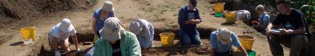
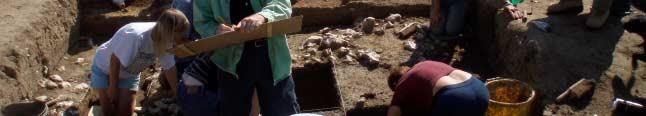
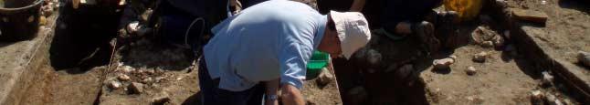
95 Arlington Page 2 of 2
96 EXCAVATIONS AT VARLEY HALLS (Casual Notes by John Funnell) Introduction In July and August of 2008 members of the BHAS Field Unit joined Lisa Fisher, a student from Sussex University for an excavation at Varley Halls, Coldean, Brighton. The project was carried out under the auspices of the Brighton and Hove Archaeological Society and supported by manpower from the Society and other parties. A brief had been submitted to Brighton and Hove City Council and the County Archaeologist who had approved the investigation prior to the commencement of the excavations. The excavation was to focus on a ploughed out lynchet that runs across the field which is located west of the Varley Halls of residence complex. The lynchet is a distinct linear feature known about from aerial photographs, but with very little contour evidence on the ground. The field was ploughed for some considerable time before the tenant farmer released the tenancy from which time the field has lain fallow. The field lies between the known Bronze Age sites at Downsview (Rudling) and Varley Halls (Greig) which were excavated prior to and just after the completion of the Brighton bypass. The field was field walked by BHAS as an assessment for the bypass (Hartridge & Kenward) and later in 1995 (Funnell). The field walking produced finds from the Iron Age and Roman periods with flint work indicating activities during the prehistoric period. The field walking produced very little artefacts in concentrated areas, suggesting that there are no other settlements between the two known Bronze Age sites. The initial stage of the new project was a large geophysical survey that produced clear images of the feature to be investigated. (Fig 1.) A total of 3 trenches were opened with the main trench measuring 10 metres in length and 2 metres in width being the main focus of attention cutting through the lynchet. The other trenches examined other geophysical anomalies and were quite small trenches measuring only 2 metres in length and 1 metre in width. The Excavations The main trench was excavated down to the chalk bedrock and the stratigraphy recorded through section drawing. All of the finds were recorded three dimensionally in an attempt to produce a detailed stratigraphy and note the finds from the various layers. The lynchet proved to be a very shallow feature comprised of a dark, clay like, loam. It was quite distinct in the section. There was no evidence for a negative lynchet of the south side. The lynchet appeared as shallow bank and was carefully sectioned, but it produced no real dateable finds. The small trench to the east of the main excavation revealed only natural chalk and nothing to indicate the anomaly revealed in the geophysical survey. A similar sized trench to the west of the main excavation again failed to find any archaeological features, but did produce a small number of sherds of Bronze Age/ Iron Age pottery. Varley Hall Part 1 Page 1 of 2
97 The Finds Field walking had produced finds of flint work and pottery clearly indicating that the area was utilised during the Iron Age and Roman periods, but nothing to suggest Bronze Age activity. It is highly likely that the delicate structure of the prehistoric pottery would not allow it to survive for too long in such aggravated and tremulous conditions. The majority of the finds consisted of Roman pottery along with a few fragments of Iron Age sherds. There was a small amount of flint work suggesting a late Neolithic to Early Bronze Age usage of the fields in ancient times. A large percentage of the finds were of glass and contemporary ceramics. One aspect of the investigations was a environmental study of the various subtle soil layers. Conclusions The excavations at Varley Halls in 2008 were a very useful investigation of open lands between Bronze Age sites. The finds were few and the paucity tends to suggest that the field was perhaps utilised more in the later Iron Age and Roman periods than the earlier prehistoric period. The investigation also raised the issue of the ploughed out lynchet and its purpose. The evidence tends to discount the feature as a lynchet, and suggest that it maybe a trackway down to the valley bottom and a possible water source. The excavation will now be a detailed report by Lisa Fisher and it is anticipated that the final draught will be deposited at Barbican House. The report will be attached to a later edition of the BHAS Field Notebook and will be placed on the BHAS website once published. The author would like to thank all of the BHAS Field Unit who helped with the field activities at Varley Halls. References:- Funnell J Fieldwalking at Varley Halls and Marquee Brow, Stanmer, Brighton Sussex Arch Colls. 140, Hartridge R. & Kenward R Fieldwalking along the proposed route of the Brighton by-pass. Sussex Arch Colls 127, Greig I Excavations of a Bronze Age settlement at Varley Halls, Coldean, Coldean Lane, Brighton. Sussex Arch Colls. 135, 7-59 Rudling D.R. et al 2002 Downland Settlement and Land-Use, The Archaeology of the Brighton Bypass. Archetype Publications. John Funnell 8 th August 2008 Varley Hall Part 1 Page 2 of 2

98 VARLEY HALLS 2008 INTERIM REPORT LISA JAYNE FISHER, UNIVERSITY OF SUSSEX In the summer of 2008 the author and several members of BHAS conducted initial archaeological investigations into the palaeo-landscape around Varley Halls of Residence, off Coldean Lane in Brighton. This BA settlement site had previously been excavated in 1991 by Ian Grieg from ASE and the site being investigated this year lies on a steep south facing slope halfway between the original excavations and a further BA settlement (Downsview) excavated by David Rudling as part of the Brighton by-pass project. It was hoped that by targeting a small area, a larger palaeo-landscape could be established whereby farming practices and maybe even territorial boundaries in the Middle Bronze Age may be further understood and investigated. It was also hoped to identify and date a linear feature running across the field. The area was originally chosen from BHAS field walking activities in 2000, with the spatial patterning of prehistoric flints used as a target to help select an area for investigation. The author then superimposed aerial photographs over the field walking results to give a clearer pattern of activity. What became very evident was a large linear feature running across the field in a diagonal manner. An area 80m x 60m was then surveyed with a small team (David, Brenda, Dot and the author) in the autumn of 2007 with the unit s resistivity meter. The results in fig.1 clearly show the linear feature, which was provisionally interpreted as a lynchet, due to it s continuity in the surrounding contours of Coldean Valley. This gave a clear target for excavation. Fig.1. Varley Halls geophysical linear feature On July 12 th 2008 the excavation began with the author directing and John Funnell supervising at weekends. Initially the methodology was to open a 1m x 10m wide strip to understand the stratigraphy. This was removed quickly by hand mattocking and the trench hit the chalk bedrock at 60cm. Once removed the stratigraphy became clearer with a lovely section face exposed (fig.2). This was then sampled by Mike Allen for soil micromorphology analysis as well as for mollusc data retrieval. The second 1m strip of the trench was then carefully hand trowelled (apart from the topsoil) with all finds from all periods 3-D recorded (i.e. eastings, northings and height above sea level). The aims of this methodology was to ascertain the position of all finds in the soil to help understand the colluvium depositions throughout different time zones, results for this are pending. Also noted was the activity of worms and bioturbation to help understand residual deposits during excavation. Varley Hall Part 2 Page 1 of 3

 overlaying the edge of")
99 The majority of finds came from within the topsoil, with very few modern artefacts and mostly BA flintwork with a total of 349 struck flints recovered. A handful of prehistoric and Roman pottery sherds have been useful in beginning to date the horizons and at the bottom of the feature we found three small fragments of a bronze alloy pin next to a sherd of BA pottery. The feature itself, once stripped of the topsoil, consisted primarily of a very low bank of flint nodules resting on the chalk bedrock with a relic prehistoric soil (turfline) overlaying the edge of the bank on the southern side (fig.2 and 3). This has been provisionally interpreted as the badly truncated remains of a positive lynchet, dated to the BA by means of a few sherds of BA pottery found lying directly underneath the bank. Later ploughing has removed the top of this lynchet which is now levelled and barely recognizable from the ground. Further down profile was a buried prehistoric rendzina soil which was virtually sterile of any artefacts. There appeared to be no negative lynchet and so this site cannot easily be interpreted or compared to some of the other well known BA lynchets in Sussex, such as Bishopstone and Bullock down, where both positive and negative lynchets are evident. Fig.2. Section face showing buried prehistoric soil horizon as dark brown layer to the right Fig.3. Vertical shot showing the turf line as a dark diagonal band next to the flint bank It is entirely possible that only the top part of the field was cultivated with the flint accumulating over time to form a boundary against a fence line. It is my guess that the bottom field, being of a very steep adverse camber, was too difficult to plough and so this may have been used as pasture for cattle. 75% of the bone assemblage from the adjacent settlement was cattle bone and I have put forward the theory that the hillside naturally inclines (a hanging valley is apparent here) towards a water collection point at the bottom of the field (red dot on fig.4). I have called this the washing machine theory as the area lies halfway between the two BA communities, I believe it may well have been a communal domestic area, but then I am often subject to fanciful thinking! However, further auguring Varley Hall Part 2 Page 2 of 3

100 and/or excavation in this area may well result in more evidence to back this theory up; there is still an existing natural pond on the other side of Coldean Lane, right opposite this area within 10m distance. It would also make sense to keep cattle on the bottom part of this field within easy reach of a natural water hole. The mollusc report backs up the evidence that the landscape consisted of open, possibly arable/pasture land but full dates and interpretation in relation to the stratigraphy is pending full analysis. At present my conclusion includes the possibility that the linear feature may have also been used as a track way running down to the water source from another settlement further upslope of Varley Halls but without further soil sampling and geophysical evidence, this theory is not confirmed but is likely. The basis of this conclusion means that further investigations will take place next summer, trying to understand the bottom of the field and to investigate an area up slope that may or may not contain further BA domestic activity. The author wishes to extend her thanks to the members of BHAS without whom the dig would have been impossible and very boring! Fig.4.The geophysics feature superimposed on the aerial photograph with the red dot indicating a likely water collection point Varley Hall Part 2 Page 3 of 3
101 SAXON BURIALS AT BEDDINGHAM In October of 2008 a request for assistance by the BHAS Field Unit was made by East Sussex County Council. Metal detectorists had found a number of burials in a field close to the Beddingham roundabout. The team opened up 3 small trenches to reveal the complete skeletons of 3 individuals. The location of the cemetery is on a slightly inclined knoll with views to the site of the Beddingham Roman villa and the Iron Age hill-fort of Caburn. The fields around Beddingham have produced other finds dated to several periods including the Neolithic, Roman and Saxon periods. (Funnell) (Rudling) The burials are not that far below the surface and are quite shallow cut graves, but as yet had not been affected by ploughing, although it was a very close situation. The burials were excavated over 4 days and the complete skeletons were removed for further examination. The burials lay in a variety of orientation, with one north/south another east/west and the third at about 45 degrees of orientation to the others. There appeared to be no distinct method or orientation for the burials. It is usual that east/west orientated burials are normally found in Saxon contexts. The burials produced a number of artefacts including weapons and a shield boss in what are thought to be male warrior burials. The third burial contained a number of brooches located close to the shoulders, and around the midriff. This burial also had a bronze or non-ferrous vessel with a handle covering the head. It is quite a unique item and very rare (A.Richardson pers. Comm.) The third burial is believed to be female from the artefacts recovered. The sex of all the skeletons will be confirmed by a more detailed examination of the remains. The field was subjected to a major resistivity and magnetometry survey and it appears that there are a number of other grave cuts. This can only be confirmed by excavation. East Sussex County Council and English Heritage have now scheduled the site to provide legal protection for the remaining grave cuts and other possible associated features. The BHAS Field Unit would like to thank ESCC for inviting them take part in this excavation. The location is being kept strictly secret until further notice. Further information can be obtained by contacting either Mr Casper Johnson, the County Archaeologist or Mr Greg Chuter at County Hall. John Funnell 24 th October 2008 References:- Funnell J.D Brighton and Hove Archaeological Society Notebook 2008 Rudling D.R. Excavations at the Beddingham Roman Villa Forthcoming Beddingham Page 1 of 1
102 EXCAVATIONS AT SOUTHWICK During the latter part of 2008 members of the BHAS Field Unit joined Giles Standing to assist with his excavations at Southwick. Giles organised the small excavation in the playing field area of Manor Hall Middle School as part of the National Archaeology Week in July. The excavation was preceded by a resistivity survey conducted by the Worthing Archaeological Society over a large part of the field. The equipment was borrowed from the Sussex Archaeological Society and Archaeology South East. The location of the excavation is only a short distance from the substantial Roman villa excavated in the 1930 s, which was dated to the first century A.D. The excavation revealed a flint constructed Roman wall, without mortar, and a chalk floor. The finds from the fills of the various features included animal bones, oyster shells, Roman bricks, roofing tile and pottery of both Iron Age and Roman periods. A number of unidentified iron objects were also recovered. Members of the BHAS field unit who assisted were Dot McBrien and Linda Wright who live locally. Susan Birks and Keith Butler went along to plan and draw the sections prior to the back filling. It is possible that a new excavation will be conducted some time in the future. John Funnell Southwick Page 1 of 1
103 Levels Taken at Southwick Excavations Saturday 15 th November 2008 and Converted to the O.D. Measurements. The 10M contour crossed at the north/west corner of the excavation Location North/West Top North/west Bottom Level M (Converted) 10.0 (On the contour line) 9.26 (This means that the excavation was 74cms deep) North/East Top North/East Stepped Depth North/East Bottom 9.25 South/west Top 10.0 South/west Bottom 9.16 South/east Top South/east Bottom Wall Top 9.56 Levels of Floor Feature in west Face, south of wall. Top 9.47 Bottom 9.27 Bottom of SW corner Ref Surface south of the wall (S/W Corner) gulley 9.2 Surface north of wall 9.07 Southwick Levels Page 1 of 1
104 GEOPHYSICS AT STAPLEFIELD In May of 2008 a small number of the BHAS Field Unit joined Sue Ray for a small resistivity survey at the Old Kennels at Staplefield. The house has a very large garden and was once terraced for the creation of a grass tennis court. The object of the survey was to seek evidence for the remains of a substantial building shown in a drawing possessed by the house owner. The resistivity survey used a TR systems machine, the measurements were in Ohms and taken at 1 metre intervals. A total of 3 grids measuring 20 metres x 20 metres were examined (Fig 1.) The ground was quite damp with rain having fallen over the preceding few weeks. A very deep garden pond is located on the north side of the garden and was not included in the survey. The results of the resistivity survey produced no evidence for any building or structure being located beneath the garden/tennis court. It is possible that the drawing has some artistic license and that the building shown is located elsewhere, or that the structure has been substantially removed, but foundation trenches should then have been produced linear arrangements of low resistance. One other possibility is that the building was never there. The author would like to thank the house owner for allowing permission to conduct the survey, Sue Ray for inviting the Society and to David Staveley and Maria Gardiner who conducted the survey. John Funnell 1 st December 2009 Staplefield Page 1 of 3
105 Staplefield Page 2 of 3

106 Staplefield Page 3 of 3
ARCHAEOLOGICAL FIELD NOTEBOOK 2009 A RECORD OF THE PROJECTS OF THE : BRIGHTON AND HOVE ARCHAEOLOGICAL SOCIETY FIELD UNIT
 ARCHAEOLOGICAL FIELD NOTEBOOK 2009 A RECORD OF THE PROJECTS OF THE : BRIGHTON AND HOVE ARCHAEOLOGICAL SOCIETY FIELD UNIT INTRODUCTION The new 2009 season of field work proved to be very active one with
ARCHAEOLOGICAL EVALUATION AT BRIGHTON POLYTECHNIC, NORTH FIELD SITE, VARLEY HALLS, COLDEAN LANE, BRIGHTON. by Ian Greig MA AIFA.
 ARCHAEOLOGICAL EVALUATION AT BRIGHTON POLYTECHNIC, NORTH FIELD SITE, VARLEY HALLS, COLDEAN LANE, BRIGHTON by Ian Greig MA AIFA May 1992 South Eastern Archaeological Services Field Archaeology Unit White
Fieldwalking at Cottam 1994 (COT94F)
") Fieldwalking at Cottam 1994 (COT94F) Tony Austin & Elizabeth Jelley (19 Jan 29) 1. Introduction During the winter of 1994 students from the Department of Archaeology at the University of York undertook
Fieldwalking at Cottam 1994 (COT94F) Tony Austin & Elizabeth Jelley (19 Jan 29) 1. Introduction During the winter of 1994 students from the Department of Archaeology at the University of York undertook
A Fieldwalking Project At Sompting. West Sussex
 by John Funnell Introduction A Fieldwalking Project At Sompting. West Sussex During March -and April 1995 the Brighton and Hove Archaeological Society conducted fie1dwa1king in a field at Sompting West
Cetamura Results
 Cetamura 2000 2006 Results A major project during the years 2000-2006 was the excavation to bedrock of two large and deep units located on an escarpment between Zone I and Zone II (fig. 1 and fig. 2);
Archaeological sites and find spots in the parish of Burghclere - SMR no. OS Grid Ref. Site Name Classification Period
 Archaeological sites and find spots in the parish of Burghclere - SMR no. OS Grid Ref. Site Name Classification Period SU45NE 1A SU46880 59200 Ridgemoor Farm Inhumation Burial At Ridgemoor Farm, on the
A visit to the Wor Barrow 21 st November 2015
 A visit to the Wor Barrow 21 st November 2015 Following our exploration of Winkelbury a few weeks previously, we fast forwarded 12 years in Pitt Rivers remarkable series of excavations and followed him
An archaeological evaluation at 16 Seaview Road, Brightlingsea, Essex February 2004
 An archaeological evaluation at 16 Seaview Road, Brightlingsea, Essex February 2004 report prepared by Kate Orr on behalf of Highfield Homes NGR: TM 086 174 (c) CAT project ref.: 04/2b ECC HAMP group site
An archaeological watching brief and recording at Brightlingsea Quarry, Moverons Lane, Brightlingsea, Essex October 2003
 An archaeological watching brief and recording at Brightlingsea Quarry, Moverons Lane, Brightlingsea, Essex commissioned by Mineral Services Ltd on behalf of Alresford Sand & Ballast Co Ltd report prepared
Archaeological Material From Spa Ghyll Farm, Aldfield
 Archaeological Material From Spa Ghyll Farm, Aldfield Introduction Following discussions with Linda Smith the Rural Archaeologist for North Yorkshire County Council, Robert Morgan of 3D Archaeological
Greater London GREATER LONDON 3/606 (E ) TQ
 TQ") GREATER LONDON City of London 3/606 (E.01.6024) TQ 30358150 1 PLOUGH PLACE, CITY OF LONDON An Archaeological Watching Brief at 1 Plough Place, City of London, London EC4 Butler, J London : Pre-Construct
GREATER LONDON City of London 3/606 (E.01.6024) TQ 30358150 1 PLOUGH PLACE, CITY OF LONDON An Archaeological Watching Brief at 1 Plough Place, City of London, London EC4 Butler, J London : Pre-Construct
AN EARLY MEDIEVAL RUBBISH-PIT AT CATHERINGTON, HAMPSHIRE Bj>J. S. PILE and K. J. BARTON
 AN EARLY MEDIEVAL RUBBISH-PIT AT CATHERINGTON, HAMPSHIRE Bj>J. S. PILE and K. J. BARTON INTRODUCTION THE SITE (fig. 21) is situated in the village of Catherington, one mile north-west of Horndean and 200
THE PRE-CONQUEST COFFINS FROM SWINEGATE AND 18 BACK SWINEGATE
 THE PRE-CONQUEST COFFINS FROM 12 18 SWINEGATE AND 18 BACK SWINEGATE An Insight Report By J.M. McComish York Archaeological Trust for Excavation and Research (2015) Contents 1. INTRODUCTION... 3 2. THE
Control ID: Years of experience: Tools used to excavate the grave: Did the participant sieve the fill: Weather conditions: Time taken: Observations:
 Control ID: Control 001 Years of experience: No archaeological experience Tools used to excavate the grave: Trowel, hand shovel and shovel Did the participant sieve the fill: Yes Weather conditions: Flurries
New Composting Centre, Ashgrove Farm, Ardley, Oxfordshire
 New Composting Centre, Ashgrove Farm, Ardley, Oxfordshire An Archaeological Watching Brief For Agrivert Limited by Andrew Weale Thames Valley Archaeological Services Ltd Site Code AFA 09/20 August 2009
39, Walnut Tree Lane, Sudbury (SUY 073) Planning Application No. B/04/02019/FUL Archaeological Monitoring Report No. 2005/112 OASIS ID no.
 Planning Application No. B/04/02019/FUL Archaeological Monitoring Report No. 2005/112 OASIS ID no.") 39, Walnut Tree Lane, Sudbury (SUY 073) Planning Application No. B/04/02019/FUL Archaeological Monitoring Report No. 2005/112 OASIS ID no. 9273 Summary Sudbury, 39, Walnut Tree Lane, Sudbury (TL/869412;
39, Walnut Tree Lane, Sudbury (SUY 073) Planning Application No. B/04/02019/FUL Archaeological Monitoring Report No. 2005/112 OASIS ID no. 9273 Summary Sudbury, 39, Walnut Tree Lane, Sudbury (TL/869412;
ARCHAEOLOGICAL FIELD NOTEBOOK 2011 A RECORD OF THE PROJECTS OF THE : BRIGHTON AND HOVE ARCHAEOLOGICAL SOCIETY FIELD UNIT
 ARCHAEOLOGICAL FIELD NOTEBOOK 2011 A RECORD OF THE PROJECTS OF THE : BRIGHTON AND HOVE ARCHAEOLOGICAL SOCIETY FIELD UNIT Introduction The new season of activities for the Brighton and Hove Archaeological
Test-Pit 3: 31 Park Street (SK )
") -Pit 3: 31 Park Street (SK 40732 03178) -Pit 3 was excavated in a flower bed in the rear garden of 31 Park Street, on the northern side of the street and west of an alleyway leading to St Peter s Church,
-Pit 3: 31 Park Street (SK 40732 03178) -Pit 3 was excavated in a flower bed in the rear garden of 31 Park Street, on the northern side of the street and west of an alleyway leading to St Peter s Church,
Former Whitbread Training Centre Site, Abbey Street, Faversham, Kent Interim Archaeological Report Phase 1 November 2009
 Former Whitbread Training Centre Site, Abbey Street, Faversham, Kent Interim Archaeological Report Phase 1 November 2009 SWAT. Archaeology Swale and Thames Archaeological Survey Company School Farm Oast,
Moray Archaeology For All Project
 School children learning how to identify finds. (Above) A flint tool found at Clarkly Hill. Copyright: Leanne Demay Moray Archaeology For All Project ational Museums Scotland have been excavating in Moray
2 Saxon Way, Old Windsor, Berkshire
 2 Saxon Way, Old Windsor, Berkshire An Archaeological Watching Brief For Mrs J. McGillicuddy by Pamela Jenkins Thames Valley Archaeological Services Ltd Site Code SWO 05/67 August 2005 Summary Site name:
Church of St Peter and St Paul, Great Missenden, Buckinghamshire
 Church of St Peter and St Paul, Great Missenden, Buckinghamshire An Archaeological Watching Brief for the Parish of Great Missenden by Andrew Taylor Thames Valley Archaeological Services Ltd Site Code
An archaeological evaluation at the Lexden Wood Golf Club (Westhouse Farm), Lexden, Colchester, Essex
, Lexden, Colchester, Essex") An archaeological evaluation at the Lexden Wood Golf Club (Westhouse Farm), Lexden, Colchester, Essex January 2000 Archive report on behalf of Lexden Wood Golf Club Colchester Archaeological Trust 12 Lexden
An archaeological evaluation at the Lexden Wood Golf Club (Westhouse Farm), Lexden, Colchester, Essex January 2000 Archive report on behalf of Lexden Wood Golf Club Colchester Archaeological Trust 12 Lexden
Chapter 2. Remains. Fig.17 Map of Krang Kor site
 Chapter 2. Remains Section 1. Overview of the Survey Area The survey began in January 2010 by exploring the site of the burial rootings based on information of the rooted burials that was brought to the
Novington, Plumpton East Sussex
 Novington, Plumpton East Sussex The Flint Over 1000 pieces of flintwork were recovered during the survey, and are summarised in Table 0. The flint is of the same types as found in the previous survey of
Cambridge Archaeology Field Group. Fieldwalking on the Childerley Estate Cambridgeshire
 Cambridge Archaeology Field Group Fieldwalking on the Childerley Estate Cambridgeshire 2009 to 2014 Summary Fieldwalking on the Childerley estate of Martin Jenkins and Family has revealed, up to March
Monitoring Report No. 99
 Monitoring Report No. 99 Enniskillen Castle Co. Fermanagh AE/06/23 Cormac McSparron Site Specific Information Site Name: Townland: Enniskillen Castle Enniskillen SMR No: FER 211:039 Grid Ref: County: Excavation
Cambridge Archaeology Field Group. Fieldwalking on the Childerley Estate, Cambridgeshire. Autumn 2014 to Spring Third interim report
 Cambridge Archaeology Field Group Fieldwalking on the Childerley Estate, Cambridgeshire Autumn 2014 to Spring 2015 Third interim report Summary Field walking on the Childerley estate of Martin Jenkins
Undley Hall, Lakenheath LKH 307
 ARCHAEOLOGICAL EVALUATION AND MONITORING REPORT SCCAS REPORT No. 2010/005 Undley Hall, Lakenheath LKH 307 E. Muldowney SCCAS January 2010 www.suffolkcc.gov.uk/e-and-t/archaeology Lucy Robinson, County
Grim s Ditch, Starveall Farm, Wootton, Woodstock, Oxfordshire
 Grim s Ditch, Starveall Farm, Wootton, Woodstock, Oxfordshire An Archaeological Recording Action For Empire Homes by Steve Ford Thames Valley Archaeological Services Ltd Site Code SFW06/118 November 2006
SALVAGE EXCAVATIONS AT OLD DOWN FARM, EAST MEON
 Proc. Hants. Field Club Archaeol. Soc. 36, 1980, 153-160. 153 SALVAGE EXCAVATIONS AT OLD DOWN FARM, EAST MEON By RICHARD WHINNEY AND GEORGE WALKER INTRODUCTION The site was discovered by chance in December
16 members of the Fieldwalking Group met York Community Archaeologist Jon Kenny at Lou Howard s farm, Rose Cottage Farm, at
 Terrington History Group Fieldwalking Group Field 1 Final report 21 October 2011 - fieldwalking 16 members of the Fieldwalking Group met York Community Archaeologist Jon Kenny at Lou Howard s farm, Rose
An archaeological evaluation in the playground of Colchester Royal Grammar School, Lexden Road, Colchester, Essex
 An archaeological evaluation in the playground of Colchester Royal Grammar School, Lexden Road, Colchester, Essex February 2002 on behalf of Roff Marsh Partnership CAT project code: 02/2c Colchester Museum
Archaeological. Monitoring & Recording Report. Fulbourn Primary School, Cambridgeshire. Archaeological Monitoring & Recording Report.
 Fulbourn Primary School, Cambridgeshire Archaeological Monitoring & Recording Report October 2014 Client: Cambridgeshire County Council OA East Report No: 1689 OASIS No: oxfordar3-192890 NGR: TL 5190 5613
FURTHER MIDDLE SAXON EVIDENCE AT COOK STREET, SOUTHAMPTON (SOU 567)
") Roc. Hampshire Field Club Archaeol. Soc 52,1997, 77-87 (Hampshire Studies 1997) FURTHER MIDDLE SAXON EVIDENCE AT COOK STREET, SOUTHAMPTON (SOU 567) By M F GARNER andj VINCENT with a contribution byjacqueline
Roc. Hampshire Field Club Archaeol. Soc 52,1997, 77-87 (Hampshire Studies 1997) FURTHER MIDDLE SAXON EVIDENCE AT COOK STREET, SOUTHAMPTON (SOU 567) By M F GARNER andj VINCENT with a contribution byjacqueline
An archaeological watching brief at Sheepen, Colchester, Essex November-December 2003
 An archaeological watching brief at Sheepen, Colchester, Essex November-December 2003 report prepared by Ben Holloway on behalf of Colchester Borough Council CAT project ref.: 03/11c Colchester Museums
Tell Shiyukh Tahtani (North Syria)
") Tell Shiyukh Tahtani (North Syria) Report of the 2010 excavation season conducted by the University of Palermo Euphrates Expedition by Gioacchino Falsone and Paola Sconzo In the summer 2010 the University
Tell Shiyukh Tahtani (North Syria) Report of the 2010 excavation season conducted by the University of Palermo Euphrates Expedition by Gioacchino Falsone and Paola Sconzo In the summer 2010 the University
7. Prehistoric features and an early medieval enclosure at Coonagh West, Co. Limerick Kate Taylor
 7. Prehistoric features and an early medieval enclosure at Coonagh West, Co. Limerick Kate Taylor Illus. 1 Location of the site in Coonagh West, Co. Limerick (based on the Ordnance Survey Ireland map)
ARCHAEOLOGICAL FIELD NOTEBOOK 2004 A RECORD OF THE PROJECTS OF THE : BRIGHTON AND HOVE ARCHAEOLOGICAL SOCIETY FIELD UNIT
 ARCHAEOLOGICAL FIELD NOTEBOOK 2004 A RECORD OF THE PROJECTS OF THE : BRIGHTON AND HOVE ARCHAEOLOGICAL SOCIETY FIELD UNIT CONTENTS INTRODUCTION... 1 EXCAVATIONS Woodingdean Cemetery Project Interim Report
Grange Farm, Widmer End, Hughenden, Buckinghamshire
 Grange Farm, Widmer End, Hughenden, Buckinghamshire An Archaeological Evaluation for British Flora by Andy Taylor Thames Valley Archaeological Services Ltd Site Code GFH 05/63 July 2005 Summary Site name:
Fieldwalk On Falmer Hill, Near Brighton - Second Season
 Fieldwalk On Falmer Hill, Near Brighton - Second Season by the Brighton and Hove Archaeological Society This report as well as describing the recent fieldwalks also includes descriptions of previous discoveries
An archaeological evaluation at the Blackwater Hotel, Church Road, West Mersea, Colchester, Essex March 2003
 An archaeological evaluation at the Blackwater Hotel, Church Road, West Mersea, Colchester, Essex report prepared by Laura Pooley on behalf of Dolphin Developments (U.K) Ltd NGR: TM 0082 1259 CAT project
St Germains, Tranent, East Lothian: the excavation of Early Bronze Age remains and Iron Age enclosed and unenclosed settlements
 Proc Soc Antiq Scot, 128 (1998), 203-254 St Germains, Tranent, East Lothian: the excavation of Early Bronze Age remains and Iron Age enclosed and unenclosed settlements Derek Alexander* & Trevor Watkinsf
Moated Site at Manor Farm, Islip, Oxfordshire
 Moated Site at Manor Farm, Islip, Oxfordshire An Archaeological Excavation By Jo Pine Site Code MFI05 December 2007 Summary Site name: Moated Site at Manor Farm, Islip, Oxfordshire Grid reference: SP 5298
Colchester Archaeological Trust Ltd. A Fieldwalking Survey at Birch, Colchester for ARC Southern Ltd
 Colchester Archaeological Trust Ltd A Fieldwalking Survey at Birch, Colchester for ARC Southern Ltd November 1997 CONTENTS page Summary... 1 Background... 1 Methods... 1 Retrieval Policy... 2 Conditions...
3. The new face of Bronze Age pottery Jacinta Kiely and Bruce Sutton
 3. The new face of Bronze Age pottery Jacinta Kiely and Bruce Sutton Illus. 1 Location map of Early Bronze Age site at Mitchelstown, Co. Cork (based on the Ordnance Survey Ireland map) A previously unknown
Essex Historic Environment Record/ Essex Archaeology and History
 Essex Historic Environment Record/ Essex Archaeology and History CAT Report 578 Summary sheet Address: Kingswode Hoe School, Sussex Road, Colchester, Essex Parish: Colchester NGR: TL 9835 2528 Type of
Greater London Region GREATER LONDON 3/567 (E.01.K099) TQ BERMONDSEY STREET AND GIFCO BUILDING AND CAR PARK
 TQ BERMONDSEY STREET AND GIFCO BUILDING AND CAR PARK") GREATER LONDON 3/567 (E.01.K099) TQ 33307955 156-170 BERMONDSEY STREET AND GIFCO BUILDING AND CAR PARK Assessment of an Archaeological Excavation at 156-170 Bermondsey Street and GIFCO Building and Car
GREATER LONDON 3/567 (E.01.K099) TQ 33307955 156-170 BERMONDSEY STREET AND GIFCO BUILDING AND CAR PARK Assessment of an Archaeological Excavation at 156-170 Bermondsey Street and GIFCO Building and Car
1 The East Oxford Archaeology and History Project
 1 The East Oxford Archaeology and History Project EXOP TEST PIT 72 Location: Bartlemas Chapel, Cowley Date of excavation: 6-8 November 2013. Area of excavation: 0.8m x 1.2m, at the eastern end of the chapel.
Small Finds Assessment, Minchery Paddock, Littlemore, Oxford (MP12)
") Small s Assessment, Minchery Paddock, Littlemore, Oxford (MP12) Introduction A total of 51 objects recovered from excavations at Minchery Paddock, Littlemore, Oxford (MP12) were submitted for dating and
Small s Assessment, Minchery Paddock, Littlemore, Oxford (MP12) Introduction A total of 51 objects recovered from excavations at Minchery Paddock, Littlemore, Oxford (MP12) were submitted for dating and
Archaeological Watching Brief (Phase 2) at Court Lodge Farm, Aldington, near Ashford, Kent December 2011
 at Court Lodge Farm, Aldington, near Ashford, Kent December 2011") Archaeological Watching Brief (Phase 2) at Court Lodge Farm, Aldington, near Ashford, Kent December 2011 SWAT. Archaeology Swale and Thames Archaeological Survey Company School Farm Oast, Graveney Road
Archaeological Watching Brief (Phase 2) at Court Lodge Farm, Aldington, near Ashford, Kent December 2011 SWAT. Archaeology Swale and Thames Archaeological Survey Company School Farm Oast, Graveney Road
THE RAVENSTONE BEAKER
 DISCOVERY THE RAVENSTONE BEAKER K. J. FIELD The discovery of the Ravenstone Beaker (Plate Xa Fig. 1) was made by members of the Wolverton and District Archaeological Society engaged on a routine field
Changing People Changing Landscapes: excavations at The Carrick, Midross, Loch Lomond Gavin MacGregor, University of Glasgow
 Changing People Changing Landscapes: excavations at The Carrick, Midross, Loch Lomond Gavin MacGregor, University of Glasgow Located approximately 40 kilometres to the south-west of Oban, as the crow flies
Peace Hall, Sydney Town Hall Results of Archaeological Program (Interim Report)
") Results of Archaeological Program (Interim Report) Background The proposed excavation of a services basement in the western half of the Peace Hall led to the archaeological investigation of the space in
Results of Archaeological Program (Interim Report) Background The proposed excavation of a services basement in the western half of the Peace Hall led to the archaeological investigation of the space in
1. Presumed Location of French Soundings Looking NW from the banks of the river.
 SG02? SGS SG01? SG4 1. Presumed Location of French Soundings Looking NW from the banks of the river. The presumed location of SG02 corresponds to a hump known locally as the Sheikh's tomb. Note also (1)
NOTE A THIRD CENTURY ROMAN BURIAL FROM MANOR FARM, HURSTBOURNE PRIORS. by. David Allen with contributions by Sue Anderson and Brenda Dickinson
 Proc. Hampsh. Field Club Archaeol. Soc. 47, 1991, 253-257 NOTE A THIRD CENTURY ROMAN BURIAL FROM MANOR FARM, HURSTBOURNE PRIORS Abstract by. David Allen with contributions by Sue Anderson and Brenda Dickinson
Evidence for the use of bronze mining tools in the Bronze Age copper mines on the Great Orme, Llandudno
 Evidence for the use of bronze mining tools in the Bronze Age copper mines on the Great Orme, Llandudno Background The possible use of bronze mining tools has been widely debated since the discovery of
MARSTON MICHAEL FARLEY
 MARSTON MICHAEL FARLEY On 9 March agricultural contractors, laying field drains for Bucks County Council Land Agent's Department, cut through a limestone structure at SP 75852301 in an area otherwise consistently
THE UNFOLDING ARCHAEOLOGY OF CHELTENHAM
 THE UNFOLDING ARCHAEOLOGY OF CHELTENHAM The archaeology collection of Cheltenham Art Gallery & Museum contains a rich quantity of material relating to the prehistoric and Roman occupation of the North
TIPPERARY HISTORICAL JOURNAL 1994
 TPPERARY HSTORCAL JOURNAL 1994 County Tipperary Historical Society www.tipperarylibraries.ie/ths society@tipperarylibraries. ie SSN 0791-0655 Excavations at Cormac's Chapel, Cashel, 1992 and 1993: a preliminary
Chapter 2: Archaeological Description
 Chapter 2: Archaeological Description Phase 1 Late Neolithic, c 3000-2400 BC (Figs 6-9) Evidence of Neolithic activity was confined to pits dug across the southern half of the site (Fig. 6). Eighteen pits
A Sense of Place Tor Enclosures
 A Sense of Place Tor Enclosures Tor enclosures were built around six thousand years ago (4000 BC) in the early part of the Neolithic period. They are large enclosures defined by stony banks sited on hilltops
Silwood Farm, Silwood Park, Cheapside Road, Ascot, Berkshire
 Silwood Farm, Silwood Park, Cheapside Road, Ascot, Berkshire An Archaeological Watching Brief For Imperial College London by Tim Dawson Thames Valley Archaeological Services Ltd Site Code SFA 09/10 April
(photograph courtesy Earle Seubert)
") THE ARCHAEOLOGY OF A CEMETERY THE TRIALS AND TRIBULATIONS OF FINDING THE LOST GRAVES OF WOODMAN POINT QUARANTINE STATION This presentation is about a project initiated by the Friends of Woodman Point and
THE ARCHAEOLOGY OF A CEMETERY THE TRIALS AND TRIBULATIONS OF FINDING THE LOST GRAVES OF WOODMAN POINT QUARANTINE STATION This presentation is about a project initiated by the Friends of Woodman Point and
BALNUARAN. of C LAVA. a prehistoric cemetery. A Visitors Guide to
 A Visitors Guide to BALNUARAN of C LAVA a prehistoric cemetery Milton of Clava Chapel (?) Cairn River Nairn Balnuaran of Clava is the site of an exceptionally wellpreserved group of prehistoric burial
Chapel House Wood Landscape Project. Interim Report 2013
 Chapel House Wood Landscape Project Interim Report 2013 Chapel House Wood Landscape Project Interim Report 2013 The annual Dales Heritage Field School was held at Chapel House Wood again this year, and
The lithic assemblage from Kingsdale Head (KH09)
") 1 The lithic assemblage from Kingsdale Head (KH09) Hannah Russ Introduction During excavation the of potential Mesolithic features at Kingsdale Head in 2009 an assemblage of flint and chert artefacts were
1 The lithic assemblage from Kingsdale Head (KH09) Hannah Russ Introduction During excavation the of potential Mesolithic features at Kingsdale Head in 2009 an assemblage of flint and chert artefacts were
ARCHAEOLOGICAL MONITORING REPORT
 ARCHAEOLOGICAL MONITORING REPORT SCCAS REPORT No. 2009/324 Thorington Hall, Stoke by Nayland SBN 087 HER Information Date of Fieldwork: November 2009 - January 2010 Grid Reference: TM 0131 3546 Funding
Bronze Age 2, BC
 Bronze Age 2,000-600 BC There may be continuity with the Neolithic period in the Early Bronze Age, with the harbour being used for seasonal grazing, and perhaps butchering and hide preparation. In the
This is a repository copy of Anglo-Saxon settlements and archaeological visibility in the Yorkshire Wolds.
 This is a repository copy of Anglo-Saxon settlements and archaeological visibility in the Yorkshire Wolds. White Rose Research Online URL for this paper: http://eprints.whiterose.ac.uk/1172/ Book Section:
Earthworks at Glebe Farm, Tilshead
 Earthworks at Glebe Farm, Tilshead Site Code TL004 Archaeological Field Evaluation And Post-Excavation Assessment Report No. 167.0801 Report date November 2011 Authors R.Holley & L.Amadio 1 Earthworks
Burrell Orchard 2014: Cleveland Archaeological Society Internship Amanda Ponomarenko The Ohio State University June - August 2014
 1 Burrell Orchard 2014: Cleveland Archaeological Society Internship Amanda Ponomarenko The Ohio State University June - August 2014 Selected for the 2014 Cleveland Archaeological Society Internship in
Caistor Roman Project Interim Summary of 2015 Season of Test pits at Caistor Old Hall
 Caistor Roman Project Interim Summary of 2015 Season of Test pits at Caistor Old Hall Introduction This brief report summarises the first results of the 2015 campaign of test-pitting in the grounds of
ARCHAEOLOGICAL S E R V I C E S. St Nicholas' Church, Barrack Hill, Nether Winchendon, Buckinghamshire. Archaeological Watching Brief.
 T H A M E S V A L L E Y ARCHAEOLOGICAL S E R V I C E S St Nicholas' Church, Barrack Hill, Nether Winchendon, Buckinghamshire Archaeological Watching Brief by Steven Crabb Site Code: STW17/229 (SP 7735
An archaeological evaluation by trial-trenching at Playgolf, Bakers Lane, Westhouse Farm, Colchester, Essex
 An archaeological evaluation by trial-trenching at Playgolf, Bakers Lane, Westhouse Farm, Colchester, Essex commissioned by Mr Stephen Belchem on behalf of ADP Ltd. report prepared by Chris Lister Planning
T so far, by any other ruins in southwestern New Mexico. However, as
 TWO MIMBRES RIVER RUINS By EDITHA L. WATSON HE ruins along the Mimbres river offer material for study unequaled, T so far, by any other ruins in southwestern New Mexico. However, as these sites are being
Archaeological evaluation at the Onley Arms, The Street, Stisted, Essex
 Archaeological evaluation at the Onley Arms, The Street, Stisted, Essex November 2014 report by Pip Parmenter and Adam Wightman with a contribution from Stephen Benfield and illustrations by Emma Holloway
Section Worked stone catalogue By Hugo Anderson-Whymark
 Section 4.11.2 Worked stone catalogue By Hugo Anderson-Whymark Table 4.67: Worked stone from Alfred s Castle. TR Ctxt SF No 1 1000 0 Weaponry Sling-shot Flint pebble 100 1 57 43 37 27 Iron Age 1 1160 0
Monitoring Report No Sacred Heart Church Aghamore Boho Co. Fermanagh AE/10/116E. Brian Sloan L/2009/1262/F
 Monitoring Report No. 202 Sacred Heart Church Aghamore Boho Co. Fermanagh AE/10/116E Brian Sloan L/2009/1262/F Site Specific Information Site Address: Sacred Heart Church, Aghamore, Boho, Co. Fermanagh
Phase 2 Urban consolidation AD
 Phase 2 Urban consolidation AD 1250-1350 The second recognised phase of activity at Rådhuspladsen corresponded approximately to the High medieval period (c. AD 1250 1350), and saw consolidation of the
DEMARCATION OF THE STONE AGES.
 20 HAMPSHIRE FLINTS. DEMARCATION OF THE STONE AGES. BY W, DALE, F.S.A., F.G.S. (Read before the Anthropological Section of -the British Association for the advancement of Science, at Birmingham, September
STONE implements and pottery indicative of Late Neolithic settlement are known to
 Late Neolithic Site in the Extreme Northwest of the New Territories, Hong Kong Received 29 July 1966 T. N. CHIU* AND M. K. WOO** THE SITE STONE implements and pottery indicative of Late Neolithic settlement
1996 Figurine Report Naomi Hamilton
 1996 Figurine Report Naomi Hamilton THE FIGURINES AND OTHER SMALL FINDS Naomi Hamilton Some preliminary comments on the distribution of certain types of artefact, with particular attention to the trench
Fort Arbeia and the Roman Empire in Britain 2012 FIELD REPORT
 Fort Arbeia and the Roman Empire in Britain 2012 FIELD REPORT Background Information Lead PI: Paul Bidwell Report completed by: Paul Bidwell Period Covered by this report: 17 June to 25 August 2012 Date
Advanced archaeology at the archive. Museum of London Support materials AS/A2 study day
 Advanced archaeology at the archive Support materials AS/A2 study day Contents National Curriculum links and session description 1-2 Example timetable 3 Practical guidelines 4 Visit preparation and pre-visit
Bronze-Age and Romano-British Sites South-East of Tewkesbury: evaluations and excavations
 From the Transactions of the Bristol and Gloucestershire Archaeological Society Bronze-Age and Romano-British Sites South-East of Tewkesbury: evaluations and excavations 1991-7 by G. Walker, A. Thomas
An archaeological watching brief on one section of an Anglian Water main Spring Lane, Lexden, Colchester
 An archaeological watching brief on one section of an Anglian Water main Spring Lane, Lexden, Colchester April-September 2001 on behalf of Breheny Contractors CAT project ref.: 01/4D Colchester Museum
Excavation Report. Medieval Occupation at Challis Green Barrington Cambridgeshire. Excavation Report. Client: Hills Partnership Limited.
 Medieval Occupation at Challis Green Barrington Cambridgeshire Excavation Report Excavation Report April 2012 Client: Hills Partnership Limited OA East Report No: 1269 OASIS No: oxfordar3-102493 NGR: TL
A NEW ROMAN SITE IN CHESHAM
 A NEW ROMAN SITE IN CHESHAM KEITH BRANIGAN AND MICHAEL KIRTON THE site under discussion was first noted in 1958 and since that time several discoveries have been made. Its investigation has been pursued
Wantage County Primary School, Garston Lane, Wantage, Oxfordshire
 Wantage County Primary School, Garston Lane, Wantage, Oxfordshire An Archaeological Evaluation for Oxfordshire County Council by Erlend Hindmarch Thames Valley Archaeological Services Ltd Site Code GLW
Lanton Lithic Assessment
 Lanton Lithic Assessment Dr Clive Waddington ARS Ltd The section headings in the following assessment report refer to those in the Management of Archaeological Projects (HBMC 1991), Appendix 4. 1. FACTUAL
AREA C. HENRY 0. THOMPSON American Center of Oriental Research Amman, Jordan
 AREA C HENRY 0. THOMPSON American Center of Oriental Research Amman, Jordan Of the 1971 work previously reported,' Squares 4,5, and 6 were not excavated in 1973, but work in Squares 1, 2, and 3 was continued.
Erection of wind turbine, Mains of Loanhead, Old Rayne, AB52 6SX
 Erection of wind turbine, Mains of Loanhead, Old Rayne, AB52 6SX Ltd 23 November 2011 Erection of wind turbine, Mains of Loanhead, Old Rayne, AB52 6SX CONTENTS 1 INTRODUCTION 3 2 ARCHAEOLOGICAL BACKGROUND
Excavations at Shikarpur, Gujarat
 Excavations at Shikarpur, Gujarat 2008-2009 The Department of Archaeology and Ancient History, the M. S. University of Baroda continued excavations at Shikarpur in the second field season in 2008-09. In
A COIN OF OFFA FOUND IN A VIKING-AGE BURIAL AT VOSS, NORWAY. Bergen Museum.
 A COIN OF OFFA FOUND IN A VIKING-AGE BURIAL AT VOSS, NORWAY. BY HAAKON SCHETELIG, Doct. Phil., Curator of the Bergen Museum. Communicated by G. A. AUDEN, M.A., M.D., F.S.A. URING my excavations at Voss
Suburban life in Roman Durnovaria
 Suburban life in Roman Durnovaria Additional specialist report Finds Ceramic building material By Kayt Brown Ceramic building material (CBM) Kayt Brown A total of 16420 fragments (926743g) of Roman ceramic
YCCCART is very grateful to Richard Broomhead for permission to publish this report online.
 YCCCART 2017/Y2 Yatton & Congresbury Wildlife Action Group A Documentary & Archaeological Survey Of Two Moorland Sites In Yatton & Congresbury R.A.Broomhead BA Field Archaeologist RAB/15/9 YCCCART is very
The lab Do not wash metal gently Never, ever, mix finds from different layers
 8 The lab 8.1 Finds processing The finds from the excavations at all parts of the site are brought down at the end of the day to the lab in the dig house. Emma Blake oversees the processing. Monte Polizzo
G. Bersu & D. Wilson. Three Viking Graves in the Isle of Man, London 1966 The Society for Medieval Archaeology Monograph Series: No.
 Scabbards 8 Ballateare & Cronk Moar in the Isle of Man Probably the best known scabbards from the period under study are the two from the Isle of Man. These were excavated primarily by the German archaeologist
EXCAVATION AT ST MARY'S ROAD, SOUTHAMPTON (SOU 379 AND SOU 1112)
") Proc. Hampshire Field Club Archaeol. Soc. 58, 2003, 106-129 (Hampshire Studies 2003) EXCAVATION AT ST MARY'S ROAD, SOUTHAMPTON (SOU 379 AND SOU 1112) By M F GARNER With contributions ^DM GOODBURN and L
Proc. Hampshire Field Club Archaeol. Soc. 58, 2003, 106-129 (Hampshire Studies 2003) EXCAVATION AT ST MARY'S ROAD, SOUTHAMPTON (SOU 379 AND SOU 1112) By M F GARNER With contributions ^DM GOODBURN and L