31 Stoke Street Ipswich, Suffolk
|
|
|
- Kathryn Hall
- 5 years ago
- Views:
Transcription

1 31 Stoke Street Ipswich, Suffolk Client: Fastracker Developments Ltd. Date: March 2015 IPS 758 Archaeological Evaluation Report SACIC Report No. 2015/009 Author: M. Sommers SACIC
2
3 31 Stoke Street, Ipswich IPS 758 Archaeological Evaluation Report SACIC Report No. 2015/009 Author: M. Sommers Contributions By: R. Goffin and M. Green Editor: S. Boulter Report Date: March 2015
4
5 HER Information Site Code: IPS 758 Site Name: 31 Stoke Street, Ipswich Report Number 2015/009 Planning Application No: IP/12/00916 Date of Fieldwork: 17th and 18th February 2015 Grid Reference: TM Oasis Reference: Curatorial Officer: Project Officer: Client/Funding Body: Client Reference: suffolkc Dr A. Antrobus M. Sommers Fastracker Developments Ltd. n/a Digital report submitted to Archaeological Data Service: Disclaimer Any opinions expressed in this report about the need for further archaeological work are those of Suffolk Archaeology CIC. Ultimately the need for further work will be determined by the Local Planning Authority and its Archaeological Advisors when a planning application is registered. Suffolk Archaeology CIC cannot accept responsibility for inconvenience caused to the clients should the Planning Authority take a different view to that expressed in the report. Prepared By: M. Sommers Date: 4th March 2015 Approved By: Position: Date: Signed: S. Boulter Senior Project Officer
6
7 Contents Summary 1. Introduction 1 2. Geology and topography 1 3. Archaeology and historical background 3 4. Methodology 5 5. Results 7 6. Finds and environmental evidence Introduction The Pottery The Fired clay The struck flint Faunal remains Discussion Conclusions and recommendations for further work Archive deposition Acknowledgements Bibliography 15 List of Figures Figure 1. Location map 2 Figure 2. Trench location and summary of recorded features 6 Figure 3. Trench 1 - plan 9 Figure 4. Sections 10 List of Tables Table 1. Summary of HER entries 4 Table 2. Finds quantities 11
8 List of Plates Plate 1. Trench 1, pits 0001 and 0003, camera facing northeast (ref. HZI 84) 16 Plate 2. Trench 1, ditch 0006, camera facing southeast (ref. HWZ 87) 16 Plate 3. Trench 1, pit 0008, camera facing south (ref. HZI 89) 17 Plate 4. Trench 1, pit 0010, camera facing west (ref. HZI 91) 17 Plate 5. Trench 1, pit 0012, camera facing east (ref. HZI 93) 18 Plate 6. Trench 2, general view, camera facing west (ref. HWZ 96) 18 List of Appendices Appendix 1. Appendix 2. Appendix 3. Appendix 4. Written Scheme of Investigation Context List OASIS data collection form Pottery catalogue
9 Summary An archaeological evaluation was carried out at 31 Stoke Street, Ipswich, in advance of a residential development. Two trenches were excavated revealing a small number of features. Finds evidence suggests that at least some of these date from the medieval period. These were interpreted as rubbish pits suggesting occupation in the immediate vicinity, presumably on the street frontage, an area now under later buildings. The site was located in an area that sloped down from west to east and to the north, although this is now heavily landscaped. On the street frontage and along the western arm of the L shaped site it was clear that the surface of the natural subsoil had been truncated to form a roughly level terrace and that Stoke Street itself in this area is a sunken lane cut into the side of the slope. This is further evidenced by the presence of a revetting wall topped by a steep slope on the west side of the street, adjacent to St. Mary s churchyard. Occasional sherds of Middle Saxon Ipswich ware and some possible Late Saxon Thetford-type ware were also recovered as residual finds in the medieval features (Suffolk Archaeology CIC for Fastracker Developments Ltd.)
10
11 1. Introduction Planning permission has been granted for a residential development on land at 31, Stoke Street, Ipswich, Suffolk (application number IP/12/00916). One of the conditions attached to the planning consent called for a programme of archaeological work to be in place in advance of this development. The first stage of the programme of work, as specified in a Brief produced by Dr. Abby Antrobus of the Suffolk County Council Conservation Team, was the undertaking of a trenched evaluation in order to ascertain what levels of archaeological evidence may be present within the development area and to inform any mitigation strategies that may then be deemed necessary. Based on this brief a Written Scheme of Investigation (WSI) was produced and subsequently approved by the Conservation Team (Appendix 1). The National Grid Reference for the approximate centre of the site is TM Figure 1 shows a location plan of the site. The archaeological evaluation was carried out on the 17th and 18th February 2015 by Suffolk Archaeology Community Interest Company (SACIC) who were commissioned by Peter Wells Architects Ltd., acting on the behalf of their client, Fastracker Developments Ltd. 2. Geology and topography The development area is located at between c.10m and 11m above sea level, on a northeast facing slope that runs from a high area to the west down to the River Orwell, which flows west to east in a channel approximately 90m to the north. This slope has been previously landscaped and now forms a series of terraces divided by occasional small pockets of what are possibly remnants of the natural slope. Stoke Street, to the west of the site, climbs up from the north along the eastern boundary of St. Mary s churchyard, from which it is separated by a brick built revetting wall with a steep slope beyond. The underlying geology consists of clay, silt and sand of the Thanet Sand Formation And Lambeth Group, which is overlain with sand and gravel deposits (British Geological Survey). 1


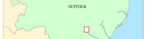

12 Contains Ordnance Survey data Crown copyright 2015 Figure 1. Location map 2
13 3. Archaeology and historical background A number of archaeological sites or findspots are recorded on the Historic Environment Record (HER) within the vicinity of the development site. A summary of these entries is presented in the following table; the recorded locations of which are marked in Figure 1. HER No. Address Date Nature of Evidence IPS055 Foundry Lane/College Street Sax Pair of bone skates with skeleton of a youth at depth of 11 feet, in old river mud, found in E corner of Foundry Lane & College Street. IPS072 Stoke Hill Pal Flint implements and Pleistocene mammals. Found in construction of Stoke Hill Tunnel. Investigation of the railway cutting etc. revealed a black layer of bones and associated flints (Stoke bone beds, probably from Ipswichian Interglacial). IPS139 Church of St Mary, Stoke Med St. Mary's Church new nave, chancel and S porch. Original church became north aisle and Lady Chapel. IPS141 Vernon Street Sax, Med & PMed Excavation revealed a large ditch 4m by 1.65m, four pits (plus two aceramic pits), group of undateable post holes and a foundation trench. Finds include bronze tweezers, pin, sheepbell, iron pin, knives, shears, handle, arm with shaped copper alloy terminal, rhenish lava quern, glass fragments, loomweight, bone comb fragments and needles. Pottery: Ipswich ware, Badorf type ware, relief band amphora. Jet fragments. Residual worked flint and Rom tile also recovered. IPS142 Great Whip Street /Gower Street Sax Ipswich ware in lower topsoil and Thetford type ware from in foundation trenches dug for new warehouse. Waterlogged remains reported but these were not seen by archaeologists at the time. IPS143 IPS144 Great Whip Street Great Whip Street Rom, Sax & Med Sax & Med Excavation revealed one pit (?Rom) and residual finds along with Middle and Late Saxon features. Also Medieval pits and an oven. Excavation revealed Middle Saxon features and finds and one Late Saxon slot. Also three pits C11/C12, ditch parallel to Great Whip Street, two pits later Med. IPS145 Stoke Med Hospital of St Leonard, Leper Hospital, relying chiefly on the alms of travellers. Approximate position in parish of St Peter, near church of St Augustine. IPS215 Grey Friars Road Sax, Med & PMed An area of Sax/Med occupation, now a car park. Excavations have revealed pits ranging in date from the C9 to the PMed period. IPS223 Wolsey Gate, College Street Med Brick gateway originally belonging to a proposed college which Wolsey was to set up at Ipswich. Over the door the coat of arms of the cardinal. The gateway was erected in
14 IPS255 Stoke Mill, Stoke Bridge Med & PMed Stoke Mill & bridge across the Orwell/Gipping shown on Bowen's, Hodskinson's, Saxton's & Speede's maps. Construction dates unknown although Stoke Bridge is one of two (also Handford) earliest documented bridges in Suffolk, being recorded in c.970. IPS269 Foundry Lane PMed Narrow slipway shown on 1837 drawings of Ipswich Dock area by Edward Caley. Foundry Lane appears to be on same alignment as the slipway which was presumably filled in upon construction of the Wet Dock. IPS270 Stoke Quay Pmed King's Cooperidge marked on map of Shipyard marked on map of Site later cut through by the New Cut in 1830s. IPS274 Church of St Peter Med Church of St Peter. Now disused. Close to Augustinian Priory of St Peter & St Paul. Probably connected with Wolsey's College when the church served as a chapel to the college. IPS278 Church of St Mary at the Quay, Foundation St Med IPS413 Ipswich Sax & Med Church of St Mary at the Quay. Redundant. Brasses removed to Christchurch Mansion Museum, the font to Brantham and the pulpit to Elmsett. Medieval (including Saxon) town, defined as Area of Archaeological Importance in Local Plan. IPS455 Former Cardinal Works Site Sax, Med & PMed Evaluation identified Early Saxon pottery, while only occurring in later features, the Early Saxon pottery must relate to the earliest pre-urban phase of occupation that developed into the town of Ipswich. Middle Saxon, Late Saxon and early medieval features were also widespread throughout the site. Predominantly comprising pits, there were also three substantial buildings, two surface lain, of post and slot construction with clay floors, and one possible Sunken Featured Building. IPS517 Rectory Road PMed Brickworks and kiln mapped by OS in 1880s. No longer mapped by 1900s. IPS630 Commercial Road Med? Evaluation revealed a series of undated stakes and two ditches running parallel to the buried "Gipping Channel", possibly part of a flood defence system, aimed at keeping tidal water in the Gipping channel from flooding the drained marshes. They are possibly medieval in date. IPS643 Stoke Quay Sax & Med Evaluation in 2011 identified a medieval cemetery and excavation in 2012 revealed the Norman church of St Augustine (replacing earlier timber structure) and remainder of the cemetery (at least 1000 burials) and numerous medieval and Saxon features/finds. Med occupation traces across the whole site but concentrated close to Whip Street. Table 1. Summary of HER entries 4
15 The recorded sites indicate significant Saxon and medieval occupation in the immediate vicinity of the development site. The site also lies within the area defined for the Saxon and medieval town of Ipswich and is adjacent to the Church of St. Mary, primarily a medieval building (although greatly extended in the Victorian period). Given the proximity of the recorded sites, the adjacent church and the development site s location within the limits of the Saxon and medieval town there was deemed to be a high potential for further archaeological deposits to be present within the development area. 4. Methodology The trial trenches were machine excavated down to the level of the natural subsoil using a toothless bucket fitted to a small (3.5 tonne) mechanical excavator. The machining of the trenches was closely observed throughout in order to identify any archaeological features and deposits and to recover any artefacts that might be revealed. Excavation continued until undisturbed natural deposits were encountered, the exposed surface of which was then examined for cut features. Features or significant deposits identified were then sampled through hand excavation in order to determine their depth and shape and to recover datable artefacts. Scale plans and sections of each recorded feature were drawn in pencil on permatrace sheets. Relative heights were measured with a dumpy level and related to an incised Ordnance Survey bench mark on the nearby Church of St. Mary (recorded height 16.61m OD). A photographic record of the work undertaken was also compiled using an 18 megapixel digital camera. Following excavation of each trench, the nature of the overburden was recorded and the depths noted. The location of each trench was then related to the site boundary using 30m measuring tapes. 5


16 Figure 2. Trench location and summary of recorded features 6
17 5. Results Two evaluation trenches were excavated. One 17m in length (Trench 1) and the other 14.5m in length (Trench 2). Within Trench 1 a number of features were identified. The trench locations and a summary of the recorded features over a plan of the proposed development (extract from drawing PW568-PL01, dated Oct 2012) are marked in Figure 2. A larger scale plan of Trench 1 is presented as Figure 3 and the recorded sections are reproduced in Figure 4. Trench 1 was aligned approximately north to south along an area of site that sloped down gently to the north. Six features of potential archaeological significance were recorded along with two clearly modern disturbances. For much of the southern end of the trench the subsoil lay at a depth of c.0.6m below the ground level before dipping to a depth of c.1m below ground level at the northern end. The relative heights of the present ground level and the surface of the subsoil are marked in Figure 3. At the northern, lower end of the trench the natural subsoil comprised a clayey sand with broken flint, which became increasingly sandy towards the south. The overburden consisted of a thin patchy layer of crushed brick rubble and small fragments of concrete over a deposit of relatively sterile dark silt/loamy topsoil which increased in thickness towards the northern end of the trench. This overlay a layer of pale greyish-yellow sand, which lay directly over the natural subsoil. The recorded features are as follows: 0001: An irregular shaped pit of which an unknown proportion lay beyond the western edge of the trench (plate 1). The feature cut the natural subsoil to a depth of c.0.45m and was filled with a single homogenous deposit of dark brown sandy silt (0002), which yielded sherds of pottery dated to the medieval period along with a small number of residual Anglo-Saxon sherds. Cut by the adjacent pit : A second irregular shaped pit, adjacent to and cutting pit 0001 (plate 1), larger, although the precise dimensions were unknown as a proportion lay beyond the eastern edge of the trench, and significantly deeper, cutting the natural subsoil to a depth of 0.8m. Two fills were evident, a lower fill (0004) of very dark brown to black sandy silt 7
18 overlain by a deposit of a similar but slightly paler material (0005). A number of finds were recovered from the upper fill, these have been dated to the medieval period although some may be earlier. 0006: A linear feature, probably a boundary ditch (plate 2). It measured 0.5m in width and cut the natural subsoil to a depth of 0.24m. The fill (0007) comprised a dark grey brown sandy silt which yielded a single sherd of possibly medieval pottery. 0008: A large pit, sub-circular in shape with near vertical sides and flat base at a depth of 0.82m below the level of the natural subsoil (plate 3). The fill (0009) consisted of dark brown to black silty sand from which no finds were recovered 0010: A pit located on and beyond the western edge of the trench (plate 4). Cuts the natural subsoil to a depth of 0.32m. The fill (0011) consists of dark grey sandy silt from which a single sherd of Hollesley-type ware dating to the late 13th-14th century was recovered. 0012: A small circular shaped pit or possible posthole measuring approximately 0.5m in diameter with near vertical sides down to flat base at a depth of 0.3m (plate 5). The fill (0013) comprised dark grey sandy silt which yielded no finds. Trench 2 was aligned approximately east to west along an area of site that sloped very gently down to the west. The relative heights recorded at each end are 10.52m at the east end and 10.39m at the west end. A number of features were revealed but all were clearly of modern origin and were not recorded (plate 6). At the east end the natural subsoil lay at a depth of c.0.45m below an overburden of dark topsoil with late postmedieval debris but this quickly rose until it lay at a depth of just 0.1m below the present ground level. The interface between the natural subsoil and the overburden was extremely sharp suggesting the surface of the natural subsoil had been truncated, presumably to create a roughly level terrace on what was likely to have originally been an east facing slope and to facilitate access onto Stoke Street, which appears to be a sunken lane running across the slope and revetted by a substantial brick wall that runs along its western edge. 8
19 Figure 3. Trench 1 - plan 9
20 Figure 4. Sections 10
21 6. Finds and environmental evidence Richenda Goffin 6.1 Introduction The small quantity of finds recovered from the features in Trench 1 of the evaluation are listed below. Context Pottery Fired clay Flint Animal bone Spotdate No. Wt/g No. Wt/g No. Wt/g No. Wt/g th-14th C L13th-14th C Medieval? L13th-14th C Total Table 2. Finds quantities 6.2 The Pottery Introduction A total of 22 fragments of pottery weighing 550g was recovered from the evaluation. The assemblage is mainly medieval, but there are a few earlier residual sherds. Methodology The ceramics were quantified using the recording methods recommended in the MPRG Occasional Paper No 2, Minimum standards for the processing, recording, analysis and publication of Post-Roman ceramics (Slowikowski et al 2001). The number of sherds present in each context by fabric, the estimated number of vessels represented and the weight of each fabric group was noted. Other characteristics such as form, decoration and condition were recorded, and an overall date range for the pottery in each context was established. The pottery was catalogued by context using letter codes based on fabric and form and the data has been inputted as on the database (Appendix 4). The codes used are based mainly on broad fabric and form types identified in Eighteen centuries of pottery from Norwich (Jennings 1981), and additional fabric types established by the Suffolk Unit (S Anderson, unpublished fabric list). 11
22 Pottery by feature Eleven sherds weighing 305g were recovered from the single fill 0002 of pit The group consists mainly of medieval coarsewares, including two fragments of a jar with a developed squared rim dating to the 13th-14th centuries. Two fragments of Gritty Ipswich wares were also present as residual finds. Further medieval sherds were found in the upper fill 0005 of pit 0003 which cut pit The group is made up of 9 fragments weighing 213g. Most of the pottery consists of wheelthrown coarseware including a fragment of a Hollesley-type jar (L13th-14th C). In addition three large reduced sherds of a heavily sooted globular vessel with a sagging base were present. The fragments could be medieval or, given the location of the site they may represent a fine variant of an Ipswich Thetford-type ware. A further fragment of Hollesley-type ware dating to the late 13th-14th century was the only pottery from fill 0011 of pit A single sherd of a thickwalled orange sandy ware with a pale grey core present in fill 0007 of the possible ditch 0006 is probably medieval, although it could perhaps be earlier in date. Discussion Small quantities of residual wares in the form of Ipswich wares and possible Ipswich Thetford-type wares were identified in features containing medieval pottery. The diagnostic fragments of medieval coarseware date to the 13th-14th century. Fill 0001 was cut by pit 0003 and both fills contained fragments of the same medieval coarseware vessel. A large thickwalled oxidised sandy ware in ditch 0006 is probably also medieval. No glazed wares were present, and the main forms represented are coarsewares. The pottery from the pits provides further evidence of medieval occupation in this part of Ipswich, with some residual wares which are commonly found on sites in central Ipswich. 12
23 6.3 The Fired clay Two fragments of fired clay were recovered from fill 0002 of pit Both are made from the same fabric, a fine matrix of poorly mixed clay with sparse calcareous inclusions, probably shell. Their function is unknown. 6.4 The struck flint A single struck flint was collected as a residual find from fill 0002 of pit It is a light grey brown flint with light grey chert patches and light patination with multiple flake scars on the dorsal edge. There is moderate edge damage with signs of retouch on one of the edges. Approximately 2% is made up of cortex. The fragment is possibly a blade core rejuvenation flake, and is most likely to date to the Neolithic/Bronze Age. 6.5 Faunal remains Three fragments of animal bone were recovered from fill 0002 of pit These include a fragment of a bovine jawbone with three molars, and the distal end of a sheep s tibia. 7. Discussion The evaluation revealed a small number of features that have been dated to the medieval period. The two larger pits at the northern end of Trench 1 (0001 and 0003) are likely to be rubbish pits and as such are evidence for medieval occupation, probable domestic dwellings that would have fronted onto Stoke Street or possibly Burrell Road to the north, both of which are likely to be early thoroughfares. No positive evidence for the presence of actual structures was identified within the trenches. Two other features (ditch 0007 and pit 0010) yielded only single sherds of medieval pottery and therefore cannot be securely dated, although they could potentially be medieval. The undated features may also be medieval, or possibly earlier, as there was no evidence to suggest they were modern. The soil profile revealed in Trench 2 suggests the area of the site adjacent to Stoke Street has been truncated. This is presumably a result of landscaping of a natural slope to create a level terrace at a similar level to Stoke Street, which appears to be a sunken lane that cuts deeply into the slope, as testified by the revetment wall and steep slope along the eastern edge of the churchyard. This truncation could potentially be medieval in date but the only features noted in this area were clearly modern. 13
24 8. Conclusions and recommendations for further work The evaluation has confirmed that archaeological features dating from the medieval period survive within the eastern, north-south arm of this L shaped site at a depths of c.0.6m increasing to c.1m to the north. The two most productive features, with regards to finds, were located close to the northern end of Trench 1. Comparison of the trench plan overlain on a plan of the proposed development, as supplied by the client (drawing PW568-PL01; dated Oct 2012 see Fig. 2), shows that these lie outside the footprint of the proposed structure, the greater part of which lies along the southern, east-west, arm of the site. The remainder of the site appears to be laid over to hardstanding or open green space, which would suggest the known area of what is relatively deeply buried archaeology is not under obvious threat, although the precise distribution and depth of any proposed groundworks associated with this development, such as service runs and soak-aways, are at present unknown. The final decision on the need for further work is at the discretion of the County Conservation Team. 9. Archive deposition Paper, digital and photographic archive will be sent to the County HER, ref. IPS758. SACCIC digital photograph refs. HZI 83 to HZI 99. The Finds archive will ultimately to be deposited with the local museums service 10. Acknowledgements The fieldwork was carried out by Tim Carter, Mark Sommers and Robert Templar. Project management was undertaken by Stuart Boulter who also provided advice during the production of the report and provided final editing. The Finds report was produced by Richenda Goffin with advice from Mike Green who identified the struck flint. 14
25 11. Bibliography Jennings, S., 1981, Eighteen Centuries of pottery from Norwich. EAA 13, Norwich Survey/NMS. Slowikowski, A., Nenk, B., and Pearce, J., 2001, Minimum standards for the processing, recording, analysis and publication of post-roman ceramics, MPRG Occasional Paper No 2. 15


26 Plates Plate 1. Trench 1, pits 0001 and 0003, camera facing northeast (ref. HZI 84) Plate 2. Trench 1, ditch 0006, camera facing southeast (ref. HZI 87) 16

 Plate 4.")
27 Plate 3. Trench 1, pit 0008, camera facing south (ref. HZI 89) Plate 4. Trench 1, pit 0010, camera facing west (ref. HZI 91) 17
 Plate 6. Trench 2, general view, camera facing west (ref.")
28 Plate 5. Trench 1, pit 0012, camera facing east (ref. HZI 93) Plate 6. Trench 2, general view, camera facing west (ref. HZI 96) 18
29 Appendix 1. Written Scheme of Investigation
30
31 31 Stoke Street Ipswich, Suffolk Archaeological Evaluation: Written Scheme of Investigation Prepared by Suffolk County Council Archaeological Service Field Team January 2015
32 Document Control Title: 31 Stoke Street, Ipswich, Suffolk, Archaeological Evaluation: Written Scheme of Investigation Date: January 2015 Issued by: Author: Suffolk County Council Archaeological Service Field Team Stuart Boulter Checked by: N/A Issued to: Suffolk County Council Archaeological Service Conservation Team and Peter Wells Architects Contents 1. Background 2. Project Objectives 3. Project Details 4. Archaeological Method Statement Figures 1. Site location 2. Site detail and proposed trench locations
33 1 Background The Field Team of the Suffolk County Council Archaeological Service (SCCAS) have been commissioned by Peter Wells Architects (on behalf of their client) to undertake a programme of archaeological evaluation on land at 31 Stoke Street, Ipswich, Suffolk (app. no. IP/12/00916) (TM ) (Figure 1). The site covers an area of approximately 0.04 hectares (400 square metres). A Brief for these works was produced by the Suffolk County Council Archaeological Service Conservation Team (hereafter SCCAS/CT) Archaeologist Abby Antrobus in a document dated 11 th December All SCCAS Field Team work will adhere to the requirements of this document. The archaeological potential for the site is based on its location within the Area of Archaeological Importance as defined for Ipswich Anglo-Saxon and medieval town ain the Ipswich Local Plan (County Historic Environment Record IPS 413). The site lies immediately east of the early church of St. Mary (IPS 139) and is close to the waterfront. There is considered to be a high potential for deposits of Anglo-Saxon and medieval date to survive on the site. This evaluation will be carried out by members of SCCAS Field Team under the supervision of Project Officer Mark Sommers. Stuart Boulter will undertake the project management. The work is projected to be undertaken in the week beginning 16 th February 2015, the fieldwork for which will last between one and two days.
34 2 Project Objectives PO1: Identify the date, approximate form and purpose of any archaeological deposit within the application area, together with its likely extent, localised depth and quality of preservation. PO2: Evaluate the likely impact of past land uses, and the possible presence of masking colluvial deposits. PO3: Establish the potential for the survival of environmental evidence. PO4: Provide sufficient information to construct an archaeological conservation strategy, dealing with preservation, the recording of archaeological deposits, timetables and orders of cost.


35 0 250 Site 500m metres Crown Copyright. All rights reserved. Suffolk County Council Licence No Figure 1. Site location 0
36 0 5 10m Trench 2 Edge of Application Area Trench 1 Crown Copyright. All rights reserved. Suffolk County Council Licence No Figure 2. Site detail and proposed trench locations
37 3 Project Details Site Name 31 Stoke Street, Ipswich Site Location/Parish Ipswich Grid Reference TM Access From Stoke Street Planning No IP/12/00916 HER No./HER Event No. IPS 758/ESF22738 OASIS Ref Suffolkc SCCAS Job Code IPSWSTO001 Type: Archaeological Evaluation Area c.0.04 hectares Project start date Week beginning 16 th February 2015 Duration Projected as 1 to 2 days on site Number of personnel on site 2 SCCAS staff Personnel and contact numbers Project Manager Stuart Boulter Assistant Project Officer (first Mark Sommers point of on-site contact) Outreach Officer Duncan Allan Finds Dept. Richenda Goffin EH Regional Science Advisor Dr Helen Chappell Sub-contractors N/A Curatorial Officer Abby Antrobus Consultant/Contact Sarah Bixby Developer - - Client Peter Wells Architects Site landowner - - Emergency contacts Local Police 10 Museum Street, Ipswich, IP1 1HT Local GP 1 Barrack Lane, Ipswich, Suffolk, IP1 3NQ Location of nearest A&E Heath Road, Ipswich, Suffolk, IP4 5PD Qualified First Aiders Mark Sommers Base emergency no. N/A Hire details Plant: Holmes Plant Accommodation Hire N/A Toilet Hire As required Tool hire: N/A Other Contacts Suffolk Fleet Maintenance Suffolk Press Office SCC Environment Strategy Emma Flint Manager SCC Health and Safety Inspector Martin Fisher
38 4 Archaeological method statement Fieldwork The archaeological fieldwork will be carried out by members of the SCCAS Field Team led by Project Officer Mark Sommers. The primary team of two will include an experienced metal detectorist/excavator from a pool of suitable staff at SCCAS. The c.0.04 hectare site is located on the eastern side of Stoke Street and is bounded to the north and south by extant buildings and to the east by an incised terrace associated with a block of flats (Figures 1 and 2). The Brief (section 4.1) states that archaeological trial-trenching should be undertaken on the site with a representative sample, which in this instance would equate to two 10m 15m long trenches with a minimum width of 1.5m (section 4.4). Figure 2 provides an indicative location for the two proposed trenches. All mechanical excavation will be undertaken using a toothless ditching bucket for a good clean cut and will be constantly supervised by an experienced archaeologist. Topsoil and overburden will be removed stratigraphically by the mechanical excavator. The trenches will be excavated down to the top of the first undisturbed archaeological horizon, or the upper surface of the naturally occurring subsoil. Spoil will be temporarily stockpiled next to the trench with topsoil stored separately to any underlying colluvial material. There may be the need to remove additional masking subsoil layers such as hillwash (colluvium). After excavation and recording, the trenches will be backfilled by pushing the upcast spoil back in sequentially using the mechanical excavator. Formal reinstatement is not the responsibility of the archaeological contractor. The character of the site suggests that it is quite possible that live services could be present. As no information has been provided by the client, any damage incurred to hitherto unknown services is not the responsibility of the archaeological contractor.
39 Although the trenches are unlikely to be deep (<1200mm is anticipated, although localised areas with colluvium could be deeper), they will be backfilled as soon as possible. Where deep trenches are left open over night to facilitate visits by various interested parties, fencing will be employed. If deposits deeper than 1200mm are encountered SCCAS/CT will be consulted in order to explore options such as shoring or battering of trenches. Archaeological features and deposits will be sampled by hand excavation and the trench bases and sections cleaned and recorded as necessary in order to satisfy the project aims. While there is a presumption that the excavation work will cause minimum disturbance consistent with adequate evaluation, with solid or bonded structural remains, building slots or post-holes preserved intact, even if sampled, the following guidelines will be maintained: A minimum of 1m wide slots will be excavated across linear features 50% of discrete features, such as pits, will be sampled, although in some instances 100% may be required Sufficient excavation will be undertaken to provide clear evidence for the period, depth and nature of any archaeological deposit. The depth and character of any colluvial or any other masking deposit will be established across the site. A site plan, which will show the trench location and other areas of investigation, feature positions and levels will be recorded, where necessary, a RTK GPS or TST will be used, otherwise trenches will located by triangulation from extant structures and boundaries. Feature sections and plans will be recorded at 1:20 or 1:50 as appropriate. Normal SCCAS Field Team conventions, compatible with the County HER, will be used during the site recording. The site will be recorded under the HER site code IPS 758 (Event No. ESF22738). All archaeological features and deposits will be recorded using standard pro forma SCCAS Field Team Context Recording Sheets.
40 A photographic record (high resolution digital) will be made during the evaluation. Metal detector searches will be made at all stages of the project covering both the upcast spoil and the base of the trenches. All pre-modern finds will be kept and no discard policy will be considered until all the finds have been processed and assessed. Finds on site will be treated according to First Aid For Finds and a conservator will be available for on-site consultation as required. All finds will be taken to the SCCAS Bury St. Edmunds office for processing, preliminary conservation and packing. Much of the archive and assessment preparation work will be done at the Bury St. Edmunds office, but in some circumstances it may be necessary to send some categories of finds to specialists working in archaeology and university departments in other parts of the country. In order to obtain palaeoenvironmental evidence, bulk soil samples (30-40 litres each) will be taken from selected archaeological features, particularly those which are both datable and interpretable, and retained until an appropriate specialist has assessed their potential for palaeoenvironmental remains. Decisions will be made on the need for further analysis following this assessment. If necessary advice will be sought from Dr Helen Chappell, English Heritage Regional Advisor in Archaeological Science, on the need for specialist environmental sampling. Two samples have been covered by the project costing, should SCCAS/CT require additional samples to be collected and processed then increased costs would be occurred. In the event of human remains being encountered on the site, guidelines from the Ministry of Justice will be followed and a suitable licence obtained before their removal from the site. Human remains will be treated at all stages with care and respect, and will be dealt with in accordance with the law. They will be recorded in situ and subsequently lifted, packed and marked to standards compatible with those described in the IFA s Technical Paper 13 Excavation and post-excavation treatment of Cremated and Inhumed Human Remains, by McKinley & Roberts. Following full recording and analysis, where appropriate, the remains will be reburied.
41 Fieldwork standards will be guided by Standards and Guidance for Archaeological Excavation (IFA, 1995, revised 2001), Standards for Field Archaeology in the East of England (EAA Occasional Papers 14, 2003), SCCAS/CT Requirements for a Trenched Archaeological Evaluation 2011 ver. 1.3 and SCCAS Archive Guidelines Due to the limited nature of the job, SCCAS staff will work from their vehicle and use public welfare facilities. Post-excavation General Post-excavation finds work will be managed by Richenda Goffin (Bury St. Edmunds Office) with the overall post-excavation reporting work the responsibility of Mark Sommers and managed by Stuart Boulter (both Ipswich Office). An archive of all records and finds will be prepared, consistent with the principles of MoRPHE. It will be adequate to perform the function of a final archive for deposition in the Archaeological Store of SCCAS/CT or in a suitable museum in Suffolk (see Archaeological Archives Forum: a guide to best practice 2007). The project manager will consult the intended archive depository before the archive is prepared regarding the specific requirements for the archive deposition and curation to include the specific cost implications of deposition. The final repository (in this SCCAS/CT) will accept the entire archive resulting from the project (both finds and written records) in order to create a complete record of the project. To that end, the archive will comply with SCCAS Archive Guidelines All site data will be entered on a computerised database compatible with the County HER. Site plans and sections will be copied/scanned and digitised to form a permanent archive on archivally stable material. Ordnance Datum levels will be on the section sheets. The photographic archive will be fully catalogued within the SCCAS photographic index.
42 All finds will be processed, marked and bagged/boxed following ICON guidelines and the requirements of the County HER. All finds will be marked with a site code and a context number. Bulk finds will be fully quantified on a computerised database compatible with the County HER. Quantification will fully cover weights and numbers of finds by OP and context with a clear statement for specialists on the degree of apparent residuality observed. Metal finds on site will be stored in accordance with ICON guidelines, initially recorded and assessed for significance before dispatch to a conservation laboratory within four weeks of the end of the excavation. All pre-modern silver, copper alloy and ferrous metal artefacts will be x-rayed and coins will be x-rayed if necessary for identification. Sensitive finds will be conserved if necessary and deposited in bags/boxes suitable for long term storage to ICON standards. All coins will be identified to a standard acceptable to normal numismatic research. Finds reports Specialist finds reports will be undertaken in-house or commissioned as necessary to meet the following requirements at assessment level: The site archive will meet the standards set by The Guideline for the preparation of site archives and assessments of all finds other than fired clay vessels of the Roman Finds Group and Finds Research Group AD (1993). The pottery will be recorded and archived to a standard consistent with the Draft Guidelines of the Medieval Pottery Research Group and Guidelines for the archiving of Roman Pottery, SGRP (ed. M.G. Darling, 1994). Environmental samples will be processed and assessed to standards set by the Regional Environmental Archaeologist (Dr Helen Chapell) with a clear statement of potential for further analysis. Animal and human bone will be quantified and assessed to a standard acceptable to national and regional English Heritage specialists.
43 An industrial waste assessment will cover all relevant material (i.e. fired clay finds as well as slag). Reporting The evaluation report will contain a stand-alone summary and a description of the excavation methodology. It will also contain a clear separation of the objective account of the archaeological evidence from its archaeological interpretation and recommendations to assist the Planning Officer. It will contain sufficient information to stand as an archive report should further work not be required. The report will present a clear and concise assessment of the archaeological value and significance of the results and will be related to relevant known archaeological information held in the Suffolk HER. The finished report will also include an opinion as to the necessity for further evaluation and the scope of these works although the final decision will be made by SCCAS/CT. No further site work will be undertaken until the evaluation results have been assessed and the need for and scope of additional work established by SCCAS/CT. Following approval of a draft copy of the report, a single hard copy as well as a digital copy of the approved report will be marked for the attention of the archaeological officer, who will deposit it with the HER. If applicable, a copy of the approved report will be sent to the local archaeological museum. An OASIS online record was initiated prior to the writing of this WSI document (Ref. suffolkc ). On completion of the projected, all the remaining applicable fields will be filled in a copy will be included in the final report and with the site archive. In addition, the final report (.pdf format) will be uploaded to the OASIS website (
44 If positive results are drawn from the project, a summary report will be prepared, in the established format, suitable for inclusion in the annual Archaeology in Suffolk section of the Proceedings of the Suffolk Institute of Archaeology and History. The summary will be included in the final report and will also be submitted to SCCAS/CT by the end of the calendar year in which the work took place.
45 Appendix 2. Context List Context Number Feature Number Feature Type Category Description Over Under Pit Cut Irregular shaped pit cut of which an unknown proportion lies beyond the western edge of the trench. Steep sided down to a flat base Pit Fill Fill of cut Consists of dark brown sandy silt with occasional small stones a small clay lumps (similar to the natural in this area of the trench). Homogenous Pit Cut Irregular shaped pit cut of which an unknown proportion lies beyond the eastern edge of the trench. Fairly steep sides down to a rounded a flattish base Pit Fill Lower fill within pit Consists of very dark brown to black sandy silt with occasional small stones Pit Fill Upper fill within pit Consists of dark brown sandy silt with occasional small stones. Homogenous Ditch Cut Probable linear feature on an approximate northwest to southeast alignment. C. 0.5m wide and 0.25m deep with a rounded profile Ditch Fill Fill of cut Consists of dark grey brown sandy silt with infrequent small stones. Single homogenous deposit Pit Cut Pit cut. Slightly larger than the width of the trench with steep, near vertical, sides down to a flat base at a depth of 0.8m Pit Fill Fill of cut 0008 consisting of dark brown to black silty sand with infrequent small stones Pit Cut Pit type feature of which an unknown proportion lay beyond the western edge of the trench. Visible portion had curving edges suggesting a circular shaped cut. With sloping sides down to a dished base Pit Fill Fill of cut 0010 consisting of dark grey brown sandy silt Pit Cut Small circular shaped cut interpreted as a probable pit. Near vertical sides down to a flat base Pit Fill Fill of cut 0012 consisting of dark grey brown sandy silt Cut by 0003 Cuts 0001
46
47 Appendix 3. OASIS data collection form OASIS ID: suffolkc Project details Project name Short description of the project 31 Stoke Street Ipswich Trenched evaluation revealed a small number of features dated to the medieval period. These were interpreted as rubbish pits suggesting occupation in the immediate vicinity, presumably on the street frontage, an area now under later buildings. Project dates Start: End: Previous/future work Any associated project reference codes Any associated project reference codes Type of project Current Land use Monument type Monument type Significant Finds Significant Finds Methods & techniques Development type Prompt Position in the planning process No / Not known IPS758 - HER event no. IP/12/ Planning Application No. Field evaluation Vacant Land 1 - Vacant land previously developed PIT Medieval DITCH Medieval POTTERY Medieval POTTERY Early Medieval ''Sample Trenches'' Urban residential (e.g. flats, houses, etc.) National Planning Policy Framework - NPPF After full determination (eg. As a condition) Project location Country Site location England SUFFOLK IPSWICH 31 Stoke Street
48 Study area Site coordinates Square metres TM N E Point Height OD / Depth Min: 8.99m Max: 9.94m Project creators Name of Organisation Suffolk Archaeology Community Interest Company Project brief originator Project design originator Project director/manager Project supervisor Type of sponsor/funding body Local Authority Archaeologist and/or Planning Authority/advisory body Suffolk Archaeology Community Interest Company Stuart Boulter Mark Sommers Land owner Project archives Physical Archive recipient Physical Archive ID Physical Contents Digital Archive recipient Digital Archive ID Digital Contents Digital Media available Paper Archive recipient Paper Archive ID Paper Contents Paper Media available Suffolk County SMR IPS758 ''Animal Bones'',''Ceramics'',''Worked stone/lithics'' Suffolk County SMR IPS758 ''other'' ''Images raster / digital photography'',''text'' Suffolk County SMR IPS758 ''other'' ''Correspondence'',''Plan'',''Section''
49 Project bibliography 1 Publication type Title Grey literature (unpublished document/manuscript) 31 Stoke Street Ipswich, Suffolk: Archaeological Evaluation Report Author(s)/Editor(s) Sommers, M. Other bibliographic details SACIC Report No. 2015/009 Date 2015 Issuer or publisher Place of issue or publication Description SACIC Needham Market printed sheets of A4 paper with card covers and a plastic comb binding Entered by MS (mark.sommers@suffolkarchaeology.co.uk) Entered on 4 March 2015
50
51 Appendix 4. Pottery catalogue Context Ceramic Period Fabric Form Dec Sherd No Estimated No Vessels (ENV) Weight (g) State Illus Comments Fabric date range Context date 0002 MS GIPS BODY A No 650(720) th-14th C 0002 MED MCW CP/JAR S No 0002 MED MCW BODY No 2 joining, Poorly mixed fabric. Developed square rim Lge sherd w sagging base. 1 micaceous 13th-14th C L12th-14th C 0002 MED MCW BODY No 3 joining body sherd L12th-14th C 0002 MED MCW BODY AA No 0005 MED MCW BODY A No Very abraded sandy sherd, poss EMW? Same vessel as one in 0002 same fabric 11th-12th C L12th-14th C 0005 MED MCW BOWL? S No Developed, squared rim 13th-14th C 13th-14th C 0005 MED HOLL CP/JAR No Developed, square rim L13th-14th C 0005 MED MCWC BODY No Oxidised, some calc leached out, poss Melton 12th-14th C 0005 MED MCW BODY No L12th-14th C 0005 MED? MCW? BODY S No 0007 MED? MCW? BODY No 0010 MED HOLL BODY APD No Wheelthrown, lge unabraded sherds, one with sagging base. Globular form, poss earlier? Dk orange fab with grey core. Sl micaceous, thickwalled with slow wheel turning Pale grey fabric, shallow applied strip L12th-14th, or poss Thet Prob med L13th-14th C Medieval? L13th-14th C
52
53
54 Suffolk Archaeology CIC Unit 5 Plot 11 Maitland Road Lion Barn Industrial Estate Needham Market Suffolk IP6 8NZ Rhodri.Gardner@suffolkarchaeology.co.uk
39, Walnut Tree Lane, Sudbury (SUY 073) Planning Application No. B/04/02019/FUL Archaeological Monitoring Report No. 2005/112 OASIS ID no.
 Planning Application No. B/04/02019/FUL Archaeological Monitoring Report No. 2005/112 OASIS ID no.") 39, Walnut Tree Lane, Sudbury (SUY 073) Planning Application No. B/04/02019/FUL Archaeological Monitoring Report No. 2005/112 OASIS ID no. 9273 Summary Sudbury, 39, Walnut Tree Lane, Sudbury (TL/869412;
39, Walnut Tree Lane, Sudbury (SUY 073) Planning Application No. B/04/02019/FUL Archaeological Monitoring Report No. 2005/112 OASIS ID no. 9273 Summary Sudbury, 39, Walnut Tree Lane, Sudbury (TL/869412;
ARCHAEOLOGICAL MONITORING REPORT
 ARCHAEOLOGICAL MONITORING REPORT SCCAS REPORT No. 2009/324 Thorington Hall, Stoke by Nayland SBN 087 HER Information Date of Fieldwork: November 2009 - January 2010 Grid Reference: TM 0131 3546 Funding
An archaeological evaluation at 16 Seaview Road, Brightlingsea, Essex February 2004
 An archaeological evaluation at 16 Seaview Road, Brightlingsea, Essex February 2004 report prepared by Kate Orr on behalf of Highfield Homes NGR: TM 086 174 (c) CAT project ref.: 04/2b ECC HAMP group site
Church of St Peter and St Paul, Great Missenden, Buckinghamshire
 Church of St Peter and St Paul, Great Missenden, Buckinghamshire An Archaeological Watching Brief for the Parish of Great Missenden by Andrew Taylor Thames Valley Archaeological Services Ltd Site Code
New Composting Centre, Ashgrove Farm, Ardley, Oxfordshire
 New Composting Centre, Ashgrove Farm, Ardley, Oxfordshire An Archaeological Watching Brief For Agrivert Limited by Andrew Weale Thames Valley Archaeological Services Ltd Site Code AFA 09/20 August 2009
Greater London GREATER LONDON 3/606 (E ) TQ
 TQ") GREATER LONDON City of London 3/606 (E.01.6024) TQ 30358150 1 PLOUGH PLACE, CITY OF LONDON An Archaeological Watching Brief at 1 Plough Place, City of London, London EC4 Butler, J London : Pre-Construct
GREATER LONDON City of London 3/606 (E.01.6024) TQ 30358150 1 PLOUGH PLACE, CITY OF LONDON An Archaeological Watching Brief at 1 Plough Place, City of London, London EC4 Butler, J London : Pre-Construct
2 Saxon Way, Old Windsor, Berkshire
 2 Saxon Way, Old Windsor, Berkshire An Archaeological Watching Brief For Mrs J. McGillicuddy by Pamela Jenkins Thames Valley Archaeological Services Ltd Site Code SWO 05/67 August 2005 Summary Site name:
Archaeological. Monitoring & Recording Report. Fulbourn Primary School, Cambridgeshire. Archaeological Monitoring & Recording Report.
 Fulbourn Primary School, Cambridgeshire Archaeological Monitoring & Recording Report October 2014 Client: Cambridgeshire County Council OA East Report No: 1689 OASIS No: oxfordar3-192890 NGR: TL 5190 5613
Test-Pit 3: 31 Park Street (SK )
") -Pit 3: 31 Park Street (SK 40732 03178) -Pit 3 was excavated in a flower bed in the rear garden of 31 Park Street, on the northern side of the street and west of an alleyway leading to St Peter s Church,
-Pit 3: 31 Park Street (SK 40732 03178) -Pit 3 was excavated in a flower bed in the rear garden of 31 Park Street, on the northern side of the street and west of an alleyway leading to St Peter s Church,
An archaeological evaluation in the playground of Colchester Royal Grammar School, Lexden Road, Colchester, Essex
 An archaeological evaluation in the playground of Colchester Royal Grammar School, Lexden Road, Colchester, Essex February 2002 on behalf of Roff Marsh Partnership CAT project code: 02/2c Colchester Museum
An archaeological evaluation at the Blackwater Hotel, Church Road, West Mersea, Colchester, Essex March 2003
 An archaeological evaluation at the Blackwater Hotel, Church Road, West Mersea, Colchester, Essex report prepared by Laura Pooley on behalf of Dolphin Developments (U.K) Ltd NGR: TM 0082 1259 CAT project
An archaeological watching brief and recording at Brightlingsea Quarry, Moverons Lane, Brightlingsea, Essex October 2003
 An archaeological watching brief and recording at Brightlingsea Quarry, Moverons Lane, Brightlingsea, Essex commissioned by Mineral Services Ltd on behalf of Alresford Sand & Ballast Co Ltd report prepared
Silwood Farm, Silwood Park, Cheapside Road, Ascot, Berkshire
 Silwood Farm, Silwood Park, Cheapside Road, Ascot, Berkshire An Archaeological Watching Brief For Imperial College London by Tim Dawson Thames Valley Archaeological Services Ltd Site Code SFA 09/10 April
Former Whitbread Training Centre Site, Abbey Street, Faversham, Kent Interim Archaeological Report Phase 1 November 2009
 Former Whitbread Training Centre Site, Abbey Street, Faversham, Kent Interim Archaeological Report Phase 1 November 2009 SWAT. Archaeology Swale and Thames Archaeological Survey Company School Farm Oast,
ARCHAEOLOGICAL EVALUATION AT BRIGHTON POLYTECHNIC, NORTH FIELD SITE, VARLEY HALLS, COLDEAN LANE, BRIGHTON. by Ian Greig MA AIFA.
 ARCHAEOLOGICAL EVALUATION AT BRIGHTON POLYTECHNIC, NORTH FIELD SITE, VARLEY HALLS, COLDEAN LANE, BRIGHTON by Ian Greig MA AIFA May 1992 South Eastern Archaeological Services Field Archaeology Unit White
Land North of Pesthouse Lane Barham Suffolk BRH 054
 Land North of Pesthouse Lane Barham Suffolk BRH 054 Archaeological Evaluation Report SCCAS Report No. 2012/142 Client: Barham Parish Council Author: Jezz Meredith September 2012 SCCAS Land North of Pesthouse
Archaeological Watching Brief (Phase 2) at Court Lodge Farm, Aldington, near Ashford, Kent December 2011
 at Court Lodge Farm, Aldington, near Ashford, Kent December 2011") Archaeological Watching Brief (Phase 2) at Court Lodge Farm, Aldington, near Ashford, Kent December 2011 SWAT. Archaeology Swale and Thames Archaeological Survey Company School Farm Oast, Graveney Road
Archaeological Watching Brief (Phase 2) at Court Lodge Farm, Aldington, near Ashford, Kent December 2011 SWAT. Archaeology Swale and Thames Archaeological Survey Company School Farm Oast, Graveney Road
ARCHAEOLOGICAL EVALUATION REPORT. Home Farm, Woolverstone
 ARCHAEOLOGICAL EVALUATION REPORT Home Farm, Woolverstone WLV 047 A REPORT ON THE ARCHAEOLOGICAL EVALUATION, 2007 Kieron Heard Field Team Suffolk County Council Archaeological Service December 2007 Lucy
Archaeological evaluation at the Onley Arms, The Street, Stisted, Essex
 Archaeological evaluation at the Onley Arms, The Street, Stisted, Essex November 2014 report by Pip Parmenter and Adam Wightman with a contribution from Stephen Benfield and illustrations by Emma Holloway
Archaeological trial-trenching evaluation at Chappel Farm, Little Totham, Essex. April 2013
 Archaeological trial-trenching evaluation at Chappel Farm, Little Totham, Essex April 2013 report prepared by Ben Holloway commissioned by Tim Harbord Associates on behalf of Mr Tom Howie Planning reference:
3. The new face of Bronze Age pottery Jacinta Kiely and Bruce Sutton
 3. The new face of Bronze Age pottery Jacinta Kiely and Bruce Sutton Illus. 1 Location map of Early Bronze Age site at Mitchelstown, Co. Cork (based on the Ordnance Survey Ireland map) A previously unknown
Fieldwalking at Cottam 1994 (COT94F)
") Fieldwalking at Cottam 1994 (COT94F) Tony Austin & Elizabeth Jelley (19 Jan 29) 1. Introduction During the winter of 1994 students from the Department of Archaeology at the University of York undertook
Fieldwalking at Cottam 1994 (COT94F) Tony Austin & Elizabeth Jelley (19 Jan 29) 1. Introduction During the winter of 1994 students from the Department of Archaeology at the University of York undertook
Colchester Archaeological Trust Ltd. A Fieldwalking Survey at Birch, Colchester for ARC Southern Ltd
 Colchester Archaeological Trust Ltd A Fieldwalking Survey at Birch, Colchester for ARC Southern Ltd November 1997 CONTENTS page Summary... 1 Background... 1 Methods... 1 Retrieval Policy... 2 Conditions...
An archaeological watching brief at St Leonard s church, Hythe Hill, Colchester, Essex
 An archaeological watching brief at St Leonard s church, Hythe Hill, Colchester, Essex report prepared by Adam Wightman on behalf of Dorvell Construction CAT project ref.: 10/5d Colchester and Ipswich
Undley Hall, Lakenheath LKH 307
 ARCHAEOLOGICAL EVALUATION AND MONITORING REPORT SCCAS REPORT No. 2010/005 Undley Hall, Lakenheath LKH 307 E. Muldowney SCCAS January 2010 www.suffolkcc.gov.uk/e-and-t/archaeology Lucy Robinson, County
An archaeological evaluation by trial-trenching at Playgolf, Bakers Lane, Westhouse Farm, Colchester, Essex
 An archaeological evaluation by trial-trenching at Playgolf, Bakers Lane, Westhouse Farm, Colchester, Essex commissioned by Mr Stephen Belchem on behalf of ADP Ltd. report prepared by Chris Lister Planning
An archaeological evaluation at the Lexden Wood Golf Club (Westhouse Farm), Lexden, Colchester, Essex
, Lexden, Colchester, Essex") An archaeological evaluation at the Lexden Wood Golf Club (Westhouse Farm), Lexden, Colchester, Essex January 2000 Archive report on behalf of Lexden Wood Golf Club Colchester Archaeological Trust 12 Lexden
An archaeological evaluation at the Lexden Wood Golf Club (Westhouse Farm), Lexden, Colchester, Essex January 2000 Archive report on behalf of Lexden Wood Golf Club Colchester Archaeological Trust 12 Lexden
Essex Historic Environment Record/ Essex Archaeology and History
 Essex Historic Environment Record/ Essex Archaeology and History CAT Report 578 Summary sheet Address: Kingswode Hoe School, Sussex Road, Colchester, Essex Parish: Colchester NGR: TL 9835 2528 Type of
Whitton Church Lane (Recreation Ground) WHI 014
 WHI 014") ARCHAEOLOGICAL EVALUATION REPORT Whitton Church Lane (Recreation Ground) WHI 014 A REPORT ON THE ARCHAEOLOGICAL EVALUATION, 2008 (Planning app. no. 1362/05/FUL) Jezz Meredith Field Team Suffolk C.C. Archaeological
ARCHAEOLOGICAL EVALUATION REPORT Whitton Church Lane (Recreation Ground) WHI 014 A REPORT ON THE ARCHAEOLOGICAL EVALUATION, 2008 (Planning app. no. 1362/05/FUL) Jezz Meredith Field Team Suffolk C.C. Archaeological
Cambridge Archaeology Field Group. Fieldwalking on the Childerley Estate, Cambridgeshire. Autumn 2014 to Spring Third interim report
 Cambridge Archaeology Field Group Fieldwalking on the Childerley Estate, Cambridgeshire Autumn 2014 to Spring 2015 Third interim report Summary Field walking on the Childerley estate of Martin Jenkins
An archaeological watching brief at Sheepen, Colchester, Essex November-December 2003
 An archaeological watching brief at Sheepen, Colchester, Essex November-December 2003 report prepared by Ben Holloway on behalf of Colchester Borough Council CAT project ref.: 03/11c Colchester Museums
Monitoring Report No. 99
 Monitoring Report No. 99 Enniskillen Castle Co. Fermanagh AE/06/23 Cormac McSparron Site Specific Information Site Name: Townland: Enniskillen Castle Enniskillen SMR No: FER 211:039 Grid Ref: County: Excavation
Grim s Ditch, Starveall Farm, Wootton, Woodstock, Oxfordshire
 Grim s Ditch, Starveall Farm, Wootton, Woodstock, Oxfordshire An Archaeological Recording Action For Empire Homes by Steve Ford Thames Valley Archaeological Services Ltd Site Code SFW06/118 November 2006
Monitoring Report No Sacred Heart Church Aghamore Boho Co. Fermanagh AE/10/116E. Brian Sloan L/2009/1262/F
 Monitoring Report No. 202 Sacred Heart Church Aghamore Boho Co. Fermanagh AE/10/116E Brian Sloan L/2009/1262/F Site Specific Information Site Address: Sacred Heart Church, Aghamore, Boho, Co. Fermanagh
63-66 Cannon Street Bury St Edmunds, Suffolk
 63-66 Cannon Street Bury St Edmunds, Suffolk Client: James Ackroyd-Cooper Date: October 2015 BSE 465 Archaeological Excavation Report SACIC Report No. 2015/053 Author: Michael Green SACIC 63-66 Cannon
ARCHAEOLOGICAL S E R V I C E S. St Nicholas' Church, Barrack Hill, Nether Winchendon, Buckinghamshire. Archaeological Watching Brief.
 T H A M E S V A L L E Y ARCHAEOLOGICAL S E R V I C E S St Nicholas' Church, Barrack Hill, Nether Winchendon, Buckinghamshire Archaeological Watching Brief by Steven Crabb Site Code: STW17/229 (SP 7735
63-66 Cannon Street Bury St Edmunds, Suffolk
 63-66 Cannon Street Bury St Edmunds, Suffolk Client: James Ackroyd-Cooper Date: March 2015 BSE 465 Archaeological Evaluation Report v0.1 SACIC Report No. 2015/017 Author: Rob Brooks SACIC 63-66 Cannon
Excavation. Post-Medieval Ditches. Land off Norwich Common Road Wymondham Norfolk. Excavation. Client: November 2013
 Land off Norwich Common Road Wymondham Norfolk. Excavation November 2013 Client: OA East Report No: 1546 OASIS No: oxfordar3-163105 NGR: TG 12770 02684 Excavation Post-Medieval Ditches Post-Medieval Ditches
An archaeological evaluation by trial-trenching at Scotts Farm, Lodge Lane, Purleigh, Essex October 2011
 An archaeological evaluation by trial-trenching at Scotts Farm, Lodge Lane, Purleigh, Essex October 2011 report prepared by Adam Wightman on behalf of Richard Emans CAT project ref.: 11/10a NGR: TL 582719
7. Prehistoric features and an early medieval enclosure at Coonagh West, Co. Limerick Kate Taylor
 7. Prehistoric features and an early medieval enclosure at Coonagh West, Co. Limerick Kate Taylor Illus. 1 Location of the site in Coonagh West, Co. Limerick (based on the Ordnance Survey Ireland map)
Greater London Region GREATER LONDON 3/567 (E.01.K099) TQ BERMONDSEY STREET AND GIFCO BUILDING AND CAR PARK
 TQ BERMONDSEY STREET AND GIFCO BUILDING AND CAR PARK") GREATER LONDON 3/567 (E.01.K099) TQ 33307955 156-170 BERMONDSEY STREET AND GIFCO BUILDING AND CAR PARK Assessment of an Archaeological Excavation at 156-170 Bermondsey Street and GIFCO Building and Car
GREATER LONDON 3/567 (E.01.K099) TQ 33307955 156-170 BERMONDSEY STREET AND GIFCO BUILDING AND CAR PARK Assessment of an Archaeological Excavation at 156-170 Bermondsey Street and GIFCO Building and Car
Grange Farm, Widmer End, Hughenden, Buckinghamshire
 Grange Farm, Widmer End, Hughenden, Buckinghamshire An Archaeological Evaluation for British Flora by Andy Taylor Thames Valley Archaeological Services Ltd Site Code GFH 05/63 July 2005 Summary Site name:
Western Triangle (former Cranfield s Mill garage), Star Lane/College Street, Ipswich IPS 584 (IAS 5804)
, Star Lane/College Street, Ipswich IPS 584 (IAS 5804)") Western Triangle (former Cranfield s Mill garage), Star Lane/College Street, Ipswich IPS 584 (IAS 5804) Archaeological Post-excavation Assessment & Updated Project Design SCCAS Report No. 2013/141 Client:
Western Triangle (former Cranfield s Mill garage), Star Lane/College Street, Ipswich IPS 584 (IAS 5804) Archaeological Post-excavation Assessment & Updated Project Design SCCAS Report No. 2013/141 Client:
Land at Ullswater Road, Campsea Ashe, Suffolk CAA 032. Archaeological Post-excavation Assessment DRAFT. Client: Flagship Housing Group
 DRAFT Land at Ullswater Road, Campsea Ashe, Suffolk CAA 032 Archaeological Post-excavation Assessment SCCAS Report No. 2013/131 Client: Flagship Housing Group Author: Mark Sommers March 2014 Suffolk County
FURTHER MIDDLE SAXON EVIDENCE AT COOK STREET, SOUTHAMPTON (SOU 567)
") Roc. Hampshire Field Club Archaeol. Soc 52,1997, 77-87 (Hampshire Studies 1997) FURTHER MIDDLE SAXON EVIDENCE AT COOK STREET, SOUTHAMPTON (SOU 567) By M F GARNER andj VINCENT with a contribution byjacqueline
Roc. Hampshire Field Club Archaeol. Soc 52,1997, 77-87 (Hampshire Studies 1997) FURTHER MIDDLE SAXON EVIDENCE AT COOK STREET, SOUTHAMPTON (SOU 567) By M F GARNER andj VINCENT with a contribution byjacqueline
S E R V I C E S. St John the Baptist Church, Penshurst, Kent. Archaeological Watching Brief. by Daniel Bray and James McNicoll-Norbury
 T H A M E S V A L L E Y ARCHAEOLOGICAL S E R V I C E S St John the Baptist Church, Penshurst, Kent Archaeological Watching Brief by Daniel Bray and James McNicoll-Norbury Site Code: JPK11/25 (TQ 5273 4385)
Oxfordshire. Wallingford. St Mary-le-More. Archaeological Watching Brief Report. Client: JBKS Architects and St Mary s Renewal Campaign.
 St Mary-le-More Wallingford Oxfordshire Archaeological Watching Brief Report February 2010 Client: JBKS Architects and St Mary s Renewal Campaign Issue No:1 OA Job No: 4432 NGR: SU 6071 8933 Archaeological
Report on an archaeological trial-trenching evaluation: proposed reservoir site, land north of Redgate House, Wherstead, Suffolk.
 Report on an archaeological trial-trenching evaluation: proposed reservoir site, land north of Redgate House, Wherstead, Suffolk. August-September 2010 report prepared by Ben Holloway and Howard Brooks
Lanton Lithic Assessment
 Lanton Lithic Assessment Dr Clive Waddington ARS Ltd The section headings in the following assessment report refer to those in the Management of Archaeological Projects (HBMC 1991), Appendix 4. 1. FACTUAL
E x cav atio n R e p o r t
 Medieval Trackway on land at Ivy Farm Royston, Hertfordshire Excavation Report E x cav atio n R e p o r t October 2011 Client: CgMs Consulting OA East Report No: 1305 OASIS No: oxfordar3-112012 NGR: TL
Cambridge Archaeology Field Group. Fieldwalking on the Childerley Estate Cambridgeshire
 Cambridge Archaeology Field Group Fieldwalking on the Childerley Estate Cambridgeshire 2009 to 2014 Summary Fieldwalking on the Childerley estate of Martin Jenkins and Family has revealed, up to March
1 The East Oxford Archaeology and History Project
 1 The East Oxford Archaeology and History Project EXOP TEST PIT 72 Location: Bartlemas Chapel, Cowley Date of excavation: 6-8 November 2013. Area of excavation: 0.8m x 1.2m, at the eastern end of the chapel.
Hadleigh Quarry (Phase 2), Peyton Hall Farm Hadleigh, Suffolk
, Peyton Hall Farm Hadleigh, Suffolk") Hadleigh Quarry (Phase 2), Peyton Hall Farm Hadleigh, Suffolk Client: J.T. Few Ltd. Date: March 2016 HAD 145 Archaeological Excavation Report SACIC Report No. 2015/088 Author: M. Sommers SACIC Hadleigh
Hadleigh Quarry (Phase 2), Peyton Hall Farm Hadleigh, Suffolk Client: J.T. Few Ltd. Date: March 2016 HAD 145 Archaeological Excavation Report SACIC Report No. 2015/088 Author: M. Sommers SACIC Hadleigh
An archaeological watching brief on one section of an Anglian Water main Spring Lane, Lexden, Colchester
 An archaeological watching brief on one section of an Anglian Water main Spring Lane, Lexden, Colchester April-September 2001 on behalf of Breheny Contractors CAT project ref.: 01/4D Colchester Museum
Erection of wind turbine, Mains of Loanhead, Old Rayne, AB52 6SX
 Erection of wind turbine, Mains of Loanhead, Old Rayne, AB52 6SX Ltd 23 November 2011 Erection of wind turbine, Mains of Loanhead, Old Rayne, AB52 6SX CONTENTS 1 INTRODUCTION 3 2 ARCHAEOLOGICAL BACKGROUND
Lodge Road Ufford UFF 040
 Lodge Road Ufford UFF 040 Archaeological Evaluation Report SCCAS Report No. 2014/121 Client: Briarly Homes Ltd & Wrentham Farms Ltd Author: Jezz Meredith November 2014 Suffolk County Council Archaeological
Rochester Road Soak-away
 Rochester Road Soak-away RAF Lakenheath, Suffolk Client: Defence Infrastructure Organisation Date: October 2015 ERL 236 Archaeological Excavation Report v0.3 SACIC Report No. 2015/005 Author: Rob Brooks
Moated Site at Manor Farm, Islip, Oxfordshire
 Moated Site at Manor Farm, Islip, Oxfordshire An Archaeological Excavation By Jo Pine Site Code MFI05 December 2007 Summary Site name: Moated Site at Manor Farm, Islip, Oxfordshire Grid reference: SP 5298
Wantage County Primary School, Garston Lane, Wantage, Oxfordshire
 Wantage County Primary School, Garston Lane, Wantage, Oxfordshire An Archaeological Evaluation for Oxfordshire County Council by Erlend Hindmarch Thames Valley Archaeological Services Ltd Site Code GLW
The Swan Hotel, Lavenham LVM 080
 The Swan Hotel, Lavenham LVM 080 Post-Excavation Assessment Report v0.4 SCCAS Report No. 2013/148 Client: TA Hotel Collection Author: Rob Brooks December/2014 Suffolk County Council Archaeological Service
Cetamura Results
 Cetamura 2000 2006 Results A major project during the years 2000-2006 was the excavation to bedrock of two large and deep units located on an escarpment between Zone I and Zone II (fig. 1 and fig. 2);
Museum of London Archaeological Archive: standards 2 Archive Components: Standards and Specifications 2.3 Finds
 Author Maloney, Cath. LAARC Version 3 Date 08/05/2013 Status Pre-publication Change History 2.9. Replacement of Registered Finds cards with image 2.3.4.3 2.8 Additions to Appendix: sample Finds Inventory
Novington, Plumpton East Sussex
 Novington, Plumpton East Sussex The Flint Over 1000 pieces of flintwork were recovered during the survey, and are summarised in Table 0. The flint is of the same types as found in the previous survey of
THE PRE-CONQUEST COFFINS FROM SWINEGATE AND 18 BACK SWINEGATE
 THE PRE-CONQUEST COFFINS FROM 12 18 SWINEGATE AND 18 BACK SWINEGATE An Insight Report By J.M. McComish York Archaeological Trust for Excavation and Research (2015) Contents 1. INTRODUCTION... 3 2. THE
Archaeological trial-trenching evaluation at Dale Hall, Cox s Hill, Lawford, Essex
 Archaeological trial-trenching evaluation at Dale Hall, Cox s Hill, Lawford, Essex Fieldwork directed by Ben Holloway report prepared by Howard Brooks with a contribution by Stephen Benfield on behalf
Excavations at Shikarpur, Gujarat
 Excavations at Shikarpur, Gujarat 2008-2009 The Department of Archaeology and Ancient History, the M. S. University of Baroda continued excavations at Shikarpur in the second field season in 2008-09. In
A Fieldwalking Project At Sompting. West Sussex
 by John Funnell Introduction A Fieldwalking Project At Sompting. West Sussex During March -and April 1995 the Brighton and Hove Archaeological Society conducted fie1dwa1king in a field at Sompting West
NOTE A THIRD CENTURY ROMAN BURIAL FROM MANOR FARM, HURSTBOURNE PRIORS. by. David Allen with contributions by Sue Anderson and Brenda Dickinson
 Proc. Hampsh. Field Club Archaeol. Soc. 47, 1991, 253-257 NOTE A THIRD CENTURY ROMAN BURIAL FROM MANOR FARM, HURSTBOURNE PRIORS Abstract by. David Allen with contributions by Sue Anderson and Brenda Dickinson
Sudbury Rugby Ground, Great Cornard COG 028 and COG 030
 Sudbury Rugby Ground, Great Cornard COG 028 and COG 030 Post-Excavation Assessment Report SCCAS Report No. 2011/195 Client: Persimmon Homes (Anglia) Ltd Authors: Abby Antrobus and Mo Muldowney October/2012
December 6, Paul Racher (P007) Archaeological Research Associates Ltd. 900 Guelph St. Kitchener ON N2H 5Z6
 Archaeological Research Associates Ltd. 900 Guelph St. Kitchener ON N2H 5Z6") Ministry of Tourism, Culture and Sport Culture Programs Unit Programs and Services Branch Culture Division 401 Bay Street, Suite 1700 Toronto ON M7A 0A7 Tel.: 416-314-2120 Ministère du Tourisme, de la
Ministry of Tourism, Culture and Sport Culture Programs Unit Programs and Services Branch Culture Division 401 Bay Street, Suite 1700 Toronto ON M7A 0A7 Tel.: 416-314-2120 Ministère du Tourisme, de la
Chapter 2. Remains. Fig.17 Map of Krang Kor site
 Chapter 2. Remains Section 1. Overview of the Survey Area The survey began in January 2010 by exploring the site of the burial rootings based on information of the rooted burials that was brought to the
Land off Lady Lane, Hadleigh HAD 089
 Land off Lady Lane, Hadleigh HAD 089 Archaeological Post-Excavation Assessment Report SCCAS Report No. 2011/054 Client: Persimmon Homes (Anglia) ltd Author: Simon Cass November 2011 Land off Lady Lane,
Archaeological sites and find spots in the parish of Burghclere - SMR no. OS Grid Ref. Site Name Classification Period
 Archaeological sites and find spots in the parish of Burghclere - SMR no. OS Grid Ref. Site Name Classification Period SU45NE 1A SU46880 59200 Ridgemoor Farm Inhumation Burial At Ridgemoor Farm, on the
AN EARLY MEDIEVAL RUBBISH-PIT AT CATHERINGTON, HAMPSHIRE Bj>J. S. PILE and K. J. BARTON
 AN EARLY MEDIEVAL RUBBISH-PIT AT CATHERINGTON, HAMPSHIRE Bj>J. S. PILE and K. J. BARTON INTRODUCTION THE SITE (fig. 21) is situated in the village of Catherington, one mile north-west of Horndean and 200
The lithic assemblage from Kingsdale Head (KH09)
") 1 The lithic assemblage from Kingsdale Head (KH09) Hannah Russ Introduction During excavation the of potential Mesolithic features at Kingsdale Head in 2009 an assemblage of flint and chert artefacts were
1 The lithic assemblage from Kingsdale Head (KH09) Hannah Russ Introduction During excavation the of potential Mesolithic features at Kingsdale Head in 2009 an assemblage of flint and chert artefacts were
St Germains, Tranent, East Lothian: the excavation of Early Bronze Age remains and Iron Age enclosed and unenclosed settlements
 Proc Soc Antiq Scot, 128 (1998), 203-254 St Germains, Tranent, East Lothian: the excavation of Early Bronze Age remains and Iron Age enclosed and unenclosed settlements Derek Alexander* & Trevor Watkinsf
An archaeological evaluation at Thistle Hall, Mope Lane, Wickham Bishops, Essex July 2009
 An archaeological evaluation at Thistle Hall, Mope Lane, Wickham Bishops, Essex July 2009 report prepared by Howard Brooks and Ben Holloway on behalf of Clarity Ecoworks Ltd CAT project ref.: 09/1f ECC
Evidence for the use of bronze mining tools in the Bronze Age copper mines on the Great Orme, Llandudno
 Evidence for the use of bronze mining tools in the Bronze Age copper mines on the Great Orme, Llandudno Background The possible use of bronze mining tools has been widely debated since the discovery of
ROMAN AND MEDIEVAL ACTIVITY IN THE UPPER WALBROOK VALLEY: EXCAVATIONS AT MOORGATE, CITY OF LONDON, EC2, 1997
 ROMAN AND MEDIEVAL ACTIVITY IN THE UPPER WALBROOK VALLEY: EXCAVATIONS AT 12 18 MOORGATE, CITY OF LONDON, EC2, 1997 Graham Bruce, Dominic Perring, Tim Stevens and Melissa Melikian SUMMARY In January and
Peace Hall, Sydney Town Hall Results of Archaeological Program (Interim Report)
") Results of Archaeological Program (Interim Report) Background The proposed excavation of a services basement in the western half of the Peace Hall led to the archaeological investigation of the space in
Results of Archaeological Program (Interim Report) Background The proposed excavation of a services basement in the western half of the Peace Hall led to the archaeological investigation of the space in
Land Adjacent 12 Stow Road, Ixworth IXW 063
 ARCHAEOLOGICAL MONITORING REPORT SCCAS REPORT No. 2010/128 Land Adjacent 12 Stow Road, Ixworth IXW 063 R. Brooks December 2010 www.suffolkcc.gov.uk/e-and-t/archaeology Lucy Robinson, County Director of
39 & 41 MEDINA AVENUE, NEWPORT, ISLE OF WIGHT AN ARCHAEOLOGICAL EVALUATION REPORT. Planning Application Ref: Pre-Application
 39 & 41 MEDINA AVENUE, NEWPORT, ISLE OF WIGHT AN ARCHAEOLOGICAL EVALUATION REPORT National Grid Reference: SZ 5025 8861 Planning Application Ref: Pre-Application By: AOC ARCHAEOLOGY GROUP Commissioned
Archaeological Material From Spa Ghyll Farm, Aldfield
 Archaeological Material From Spa Ghyll Farm, Aldfield Introduction Following discussions with Linda Smith the Rural Archaeologist for North Yorkshire County Council, Robert Morgan of 3D Archaeological
SOUTH-WEST IPSWICH AND SOUTH SUFFOLK SIXTH FORM CENTRE, PINEWOOD, IPSWICH SPT 035
 ARCHAEOLOGICAL ASSESSMENT REPORT SCCAS REPORT No. 2008/064 SOUTH-WEST IPSWICH AND SOUTH SUFFOLK SIXTH FORM CENTRE, PINEWOOD, IPSWICH SPT 035 M. Sommers January 2011 www.suffolk.gov.uk/environment/archaeology
An archaeological watching brief and evaluation at Great Notley business park, near Braintree, Essex June-September 2005
 An archaeological watching brief and evaluation at Great Notley business park, near Braintree, Essex report prepared by Kate Orr commissioned by Andrew Martin Associates Ltd on behalf of Countryside Properties
Archaeological Evaluation Report
 16-18 Church Street Brill Buckinghamshire o a February 2008 Client: Stephen Moss Developments Issue N o : 1 OA Job N o : 3858 Planning Ref N o : 06/01304 NGR: SP 6553 1377 Client Name: Stephen Moss Developments
Intermediate School Gym RAF Lakenheath, Eriswell ERL 214
 Intermediate School Gym RAF Lakenheath, Eriswell ERL 214 Archaeological Excavation Report SCCAS Report No. 2012/017 Client: Defence Infrastructure Organisation Author: Andrew Vaughan Beverton 06/2012 Intermediate
16 members of the Fieldwalking Group met York Community Archaeologist Jon Kenny at Lou Howard s farm, Rose Cottage Farm, at
 Terrington History Group Fieldwalking Group Field 1 Final report 21 October 2011 - fieldwalking 16 members of the Fieldwalking Group met York Community Archaeologist Jon Kenny at Lou Howard s farm, Rose
SALVAGE EXCAVATIONS AT OLD DOWN FARM, EAST MEON
 Proc. Hants. Field Club Archaeol. Soc. 36, 1980, 153-160. 153 SALVAGE EXCAVATIONS AT OLD DOWN FARM, EAST MEON By RICHARD WHINNEY AND GEORGE WALKER INTRODUCTION The site was discovered by chance in December
Fort Arbeia and the Roman Empire in Britain 2012 FIELD REPORT
 Fort Arbeia and the Roman Empire in Britain 2012 FIELD REPORT Background Information Lead PI: Paul Bidwell Report completed by: Paul Bidwell Period Covered by this report: 17 June to 25 August 2012 Date
Report on archaeological fieldwalking and metal-detecting survey on land adjacent to Breck Farm, Stody, Norfolk
 Report on archaeological fieldwalking and metal-detecting survey on land adjacent to Breck Farm, Stody, Norfolk report prepared by Howard Brooks and Ben Holloway with contributions by Emma Spurgeon and
Small Finds Assessment, Minchery Paddock, Littlemore, Oxford (MP12)
") Small s Assessment, Minchery Paddock, Littlemore, Oxford (MP12) Introduction A total of 51 objects recovered from excavations at Minchery Paddock, Littlemore, Oxford (MP12) were submitted for dating and
Small s Assessment, Minchery Paddock, Littlemore, Oxford (MP12) Introduction A total of 51 objects recovered from excavations at Minchery Paddock, Littlemore, Oxford (MP12) were submitted for dating and
Phase 2 Urban consolidation AD
 Phase 2 Urban consolidation AD 1250-1350 The second recognised phase of activity at Rådhuspladsen corresponded approximately to the High medieval period (c. AD 1250 1350), and saw consolidation of the
Phase V, Liberty Village, RAF Lakenheath, Eriswell ERL 203
 ARCHAEOLOGICAL EVALUATION REPORT SCCAS REPORT No. 2009/150 Phase V, Liberty Village, RAF Lakenheath, Eriswell ERL 203 J. A. Craven December 2009 www.suffolkcc.gov.uk/e-and-t/archaeology Lucy Robinson,
LAND WEST OF ELM GROVE, EBRINGTON, GLOUCESTERSHIRE. NGR: SP (centred) ARCHAEOLOGICAL EVALUATION
 ARCHAEOLOGICAL EVALUATION") LAND WEST OF ELM GROVE, EBRINGTON, GLOUCESTERSHIRE. NGR: SP 1892 4012 (centred) ARCHAEOLOGICAL EVALUATION Report No. 640 May 2009 1q LAND WEST OF ELM GROVE, EBRINGTON, GLOUCESTERSHIRE. NGR: SP 1892 4012
LAND WEST OF ELM GROVE, EBRINGTON, GLOUCESTERSHIRE. NGR: SP 1892 4012 (centred) ARCHAEOLOGICAL EVALUATION Report No. 640 May 2009 1q LAND WEST OF ELM GROVE, EBRINGTON, GLOUCESTERSHIRE. NGR: SP 1892 4012
Suburban life in Roman Durnovaria
 Suburban life in Roman Durnovaria Additional specialist report Finds Ceramic building material By Kayt Brown Ceramic building material (CBM) Kayt Brown A total of 16420 fragments (926743g) of Roman ceramic
An archaeological excavation of test-holes at St Barnabas Church, Alphamstone, Essex March and May 2007
 An archaeological excavation of test-holes at St Barnabas Church, Alphamstone, Essex March and May 2007 report prepared by Kate Orr commissioned by David Whymark Building Design and Conservation on behalf
Centre for Archaeological Fieldwork,
 Centre for Archaeological Fieldwork, School of Geography, Archaeology and Palaeoecology, Queen s University Belfast Data Structure Report No. 70 (preliminary report) Archaeological Excavations at Carrickfergus
THE RAVENSTONE BEAKER
 DISCOVERY THE RAVENSTONE BEAKER K. J. FIELD The discovery of the Ravenstone Beaker (Plate Xa Fig. 1) was made by members of the Wolverton and District Archaeological Society engaged on a routine field
Burrell Orchard 2014: Cleveland Archaeological Society Internship Amanda Ponomarenko The Ohio State University June - August 2014
 1 Burrell Orchard 2014: Cleveland Archaeological Society Internship Amanda Ponomarenko The Ohio State University June - August 2014 Selected for the 2014 Cleveland Archaeological Society Internship in