Oxfordshire. Wallingford. St Mary-le-More. Archaeological Watching Brief Report. Client: JBKS Architects and St Mary s Renewal Campaign.
|
|
|
- Preston Floyd
- 5 years ago
- Views:
Transcription

1 St Mary-le-More Wallingford Oxfordshire Archaeological Watching Brief Report February 2010 Client: JBKS Architects and St Mary s Renewal Campaign Issue No:1 OA Job No: 4432 NGR: SU Archaeological Watching Brief Report
2
3 Church of St Mary-le-More, Wallingford, Oxfordshire v.1 Client Name: Client Ref No: Document Title: Document Type: Issue/Version Number: 1 JBKS Architects and St Mary's Church Church of St Mary-le-More, Wallingford, Oxfordshire Watching Brief Report Grid Reference: NGR SU Planning Reference: OA Job Number: 4432 Site Code: WALMOM 09 Invoice Code: Receiving Museum: WALMOM WB Museum Accession No: OXCMS Event No: Oxfordshire County Museums Service Issue Prepared by Checked by Approved by Signature James Mumford 1 Project Officer Andrew Norton Senior Project Manager Edward Biddulph Senior Project Manager Document File Location Graphics File Location Illustrated by \\Server 1\Projects\St Marys Wallingford\Reports \\Servergo\invoice codes r thru z\w_codes\walmomwb Mark Gridley Disclaimer: This document has been prepared for the titled project or named part thereof and should not be relied upon or used for any other project without an independent check being carried out as to its suitability and prior written authority of Oxford Archaeology being obtained. Oxford Archaeology accepts no responsibility or liability for the consequences of this document being used for a purpose other than the purposes for which it was commissioned. Any person/party using or relying on the document for such other purposes agrees, and will by such use or reliance be taken to confirm their agreement to indemnify Oxford Archaeology for all loss or damage resulting therefrom. Oxford Archaeology accepts no responsibility or liability for this document to any party other than the person/party by whom it was commissioned. Oxford Archaeological Unit Ltd 2010 Janus House Osney Mead Oxford OX2 0ES t: +44 (0) e: oasouth@thehumanjourney.net f: +44 (0) w: oasouth.thehumanjourney.net Oxford Archaeological Unit Limited is a Registered Charity No: Oxford Archaeology (i) February 2010
4
5 Church of St Mary-le-More, Wallingford, Oxfordshire v.1 Church of St Mary-le-More, Wallingford, Oxfordshire Archaeological Watching Brief Report Written by James Mumford Illustrated by Mark Gridley Table of Contents Summary Introduction Location and scope of work Geology and topography Archaeological and historical background Acknowledgements Evaluation Aims and Methodology Aims Methodology Results Archaeological deposits Finds summary Palaeo-environmental remains Discussion...9 Appendix A. Context Inventory...10 Appendix B. Bibliography and References...11 Appendix C. Summary of Site Details...12 Oxford Archaeology Page 1 of 12 February 2010
6 Church of St Mary-le-More, Wallingford, Oxfordshire v.1 List of Figures Fig. 1 Site location Fig. 2 Site plan showing archaeological features and Section 1 List of Plates Plate 1 Medieval church wall 101, western section looking south Plate 2 Medieval church wall 101, looking east Plate 3 Grave marker 100 Plate 4 Vault 121, looking north Plate 5 Brick vault 105, looking north-east Plate 6 Brick vault 105, mason's mark Plate 7 Brick vault 122, looking south Plate 8 Brick vault 122, internal view Plate 9 Brick vault 118, looking west Plate 10 Brick vault 124, looking west Plate 11 Brick heating duct 102, looking east Plate 12 Brick heating duct 106, looking west Plate 13 Vestry wall foundation 110, looking west Plate 14 Wall footing 113, looking south Oxford Archaeology Page 2 of 12 February 2010
7 Church of St Mary-le-More, Wallingford, Oxfordshire v.1 Summary From June to December 2009 Oxford Archaeology (OA) carried out an archaeological watching brief at St Mary-le-More, Wallingford, Oxford (NGR SU ). The work was commissioned by JBKS Architects and the St Mary's Renewal Campaign in advance of the installation of new underfloor heating. The watching brief revealed the south wall of the medieval church, seven internal brick lined vaults and a late 19th-century heating system. An eighth vault and part of a boundary wall was revealed in works to the north of the church. Oxford Archaeology Page 3 of 12 February 2010
8 Church of St Mary-le-More, Wallingford, Oxfordshire v.1 1 INTRODUCTION 1.1 Location and scope of work From June 2009 to December 2009 Oxford Archaeology (OA) carried out an archaeological watching brief at St Mary-Le-More, Wallingford, Oxfordshire (Fig. 1). The work was commissioned by JBKS Architects and the St Mary's Renewal Campaign in advance of the installation of new underfloor heating All archaeological work followed an archaeological recording specification set by Julian Munby, the Oxfordshire Diocesan Archaeological Advisor (Oxford Diocese 2008). 1.2 Geology and topography The site lies on alluvium over valley gravels (Geological Survey of Great Britain, Sheet No 254) at 49 m above Ordnance Datum (OD). The site is situated in the centre of the town, immediately south of the town hall in the market place. 1.3 Archaeological and historical background The archaeological background to the watching brief was prepared for the specification for the project (Oxford Diocese 2008) and is reproduced below St Mary-le-More Church existed by when half the church was given to the abbey of St Albans by Neil Daubeney and his wife, Amice. Before 1160 the church had passed to the priory of the Holy Trinity (a cell of St Albans), from which it passed to the crown following the dissolution of the priory in It remained with the crown until 1853, apart from a brief period when it was granted to Cardinal Wolsey for the benefit of Cardinal College, Oxford. Patronage was transferred to the Bishop of Oxford The west tower and chancel walls are the only parts of the church dating from the medieval period. The tower foundations are from the 14th century or earlier, although the upper part was rebuilt in 1653 to repair damage caused by a thunderstorm in the same year. The rest of the church was completely rebuilt in 1854, when the chancel was shortened to extend the nave Excavations by Oxford Archaeological Unit in 1995 exposed the remains of the medieval south wall of the church within the present south aisle. Elsewhere in the church the layer of dust, wood chippings and rubble below the floorboards was not removed and further remains of the earlier building may have remained concealed below. The excavations also found a brick burial vault in the nave, situated close to the original extent of the chancel. It was not explored in detail (OAU 1995). 1.4 Acknowledgements OA's thanks are extended to Jill Ewbank, of JBKS Architects, and Mavis Bolton, of the St Mary's Renewal Campaign, for their help and assistance during the work. Thanks are also extended to Julian Munby of Oxford Archaeology and Brian Waller and Barry Hissey of C Wood and Son (Luton) Ltd. Oxford Archaeology Page 4 of 12 February 2010
9 Church of St Mary-le-More, Wallingford, Oxfordshire v.1 2 EVALUATION AIMS AND METHODOLOGY 2.1 Aims The principal aims of the work were to: (i) (ii) (iii) (iv) Record the location of the sub-floor and sleeper walls following the removal of pews and the boarded platforms below them. Record medieval or post-medieval floor surfaces, monuments, burials and burial vaults, and elements of earlier fabric exposed by clearance below the finished floor level. To identify and record the presence/absence, extent, condition, quality and date of archaeological remains in the areas affected by the development. To make available the results of the archaeological investigation. 2.2 Methodology Following the removal of the pews by external contractors, the exposed deposits were cleaned and examined by an archaeologist for any significant remains. Any areas above m OD were investigated to characterise the nature of the deposits. In principle any significant deposits would be further reduced by hand, and less significant deposits removed by the principal contractor Deeper excavations in advance of new drainage and services were also monitored by a suitably qualified archaeologist During the course of the work the following guidance was followed: (v) (vi) (vii) Human bone was not to be removed from the church Where burial vaults were found they were not opened Where they were found open, observed features were recorded but not disturbed All archaeological features were planned at a scale of 1:100 and where excavated their sections drawn at scales of 1:20. All excavated features were photographed using digital photography and black and white print film. A general photographic record of the work was made. Recording followed procedures detailed in the OAU Fieldwork Manual (Wilkinson 1992). Oxford Archaeology Page 5 of 12 February 2010
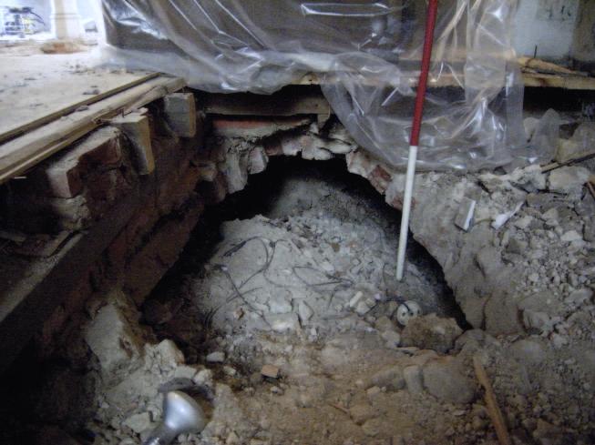
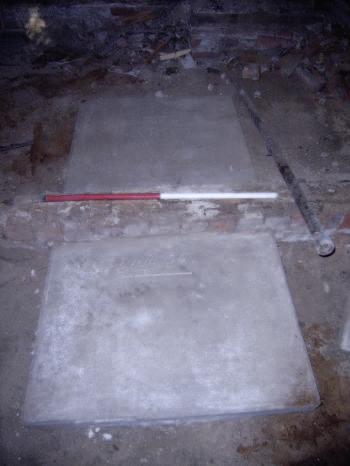
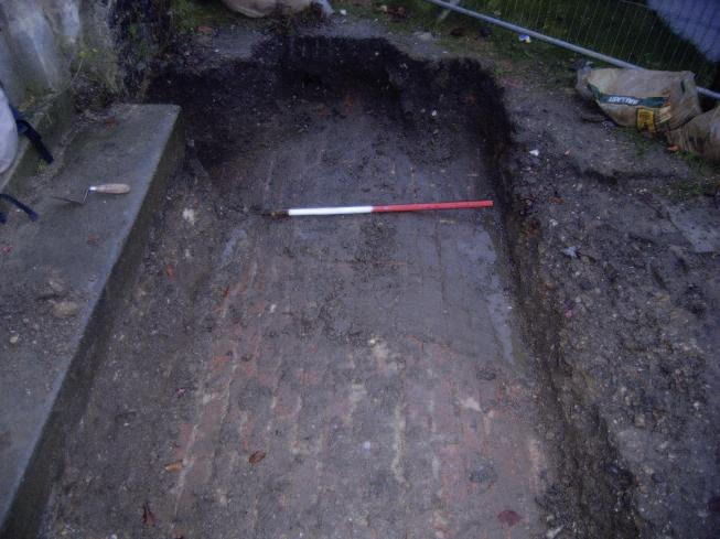
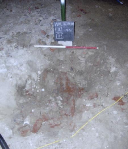
10 Church of St Mary-le-More, Wallingford, Oxfordshire v.1 3 RESULTS 3.1 Archaeological deposits The medieval church Following the removal of the pews, flooring and floor beams the earliest deposit revealed was the south wall of the medieval church (101), previously seen in the 1995 watching brief. The wall was west-east aligned and located within the south aisle (Fig. 2; Plates 1 and 2) and survived to a height of m OD. Only the upper course of the wall was exposed, which was 0.8 m wide and over 15 m long. The wall was constructed from faced limestone blocks and flint fragments, measuring 0.3 m by 0.2 m by 0.2 m. The wall was seen to return to the north in the 1995 watching brief but excavation was not as deep during the more recent works and the return was not seen. The medieval wall was abutted by a rubbly brown, silty clay loam levelling deposit (107). The deposit contained 19th-century glass and earlier redeposited pottery. A testpit to the north-west of wall 101 demonstrated that 107 was at least 0.6 m thick. 19th-century brick built vaults Church wall 101 was abutted by a probable burial vault on its north side. A rectangular cut (108) measuring 2.5 m long by 1.5 m wide was filled with a loose grey brown silty sand (109). This sand was thought to overlie a collapsed burial vault, which had been filled in during the 19th-century renovations An intact vault was revealed within the choir vestry. The top of the vault measured 2.70 m long by 1.17 m wide and was constructed from a double skin of red bricks, each measuring 0.23 m x 0.11 m x 0.08 m. The vault was overlain by a limestone gravestone (100; Plate 3) measuring 1.80 m x 0.95 m x 0.10 m. The stone was inscribed: SACRED to the memory of Sarah The wife of William B. Sheen Solicitor of this Place who died Jan. 30th 1833 Aged 49 Also of the said William Bowell Sheen who died Nov: 1835 Aged Two infilled brick-lined vaults (121) were revealed below the chancel floor and the foundations of the north chancel wall (Fig. 2; Plate 4). The tops of both vaults had collapsed and the structures had been backfilled with rubble and levelled for the laying the timber floor supports. The eastern vault was aligned north to south and measured 2.5 m x 2 m. The western vault was aligned west to east and measured 2 m x 1.75 m; its western end had been rebuilt during the construction of the heating duct 106 (see below). Both structures were constructed of a single skin of bricks, each measuring 0.22m x 0.11 m x 0.07 m. Charnel bones were observed in the backfill of the western vault, presumably a result of the disturbance of a burial during the construction of the 19th-century heating duct. Oxford Archaeology Page 6 of 12 February 2010
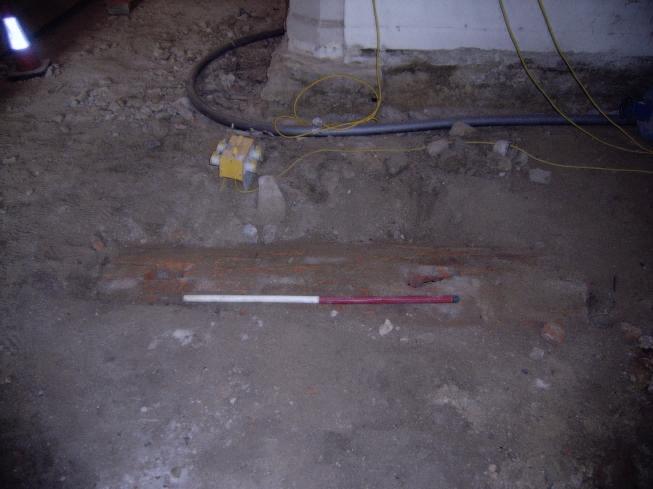
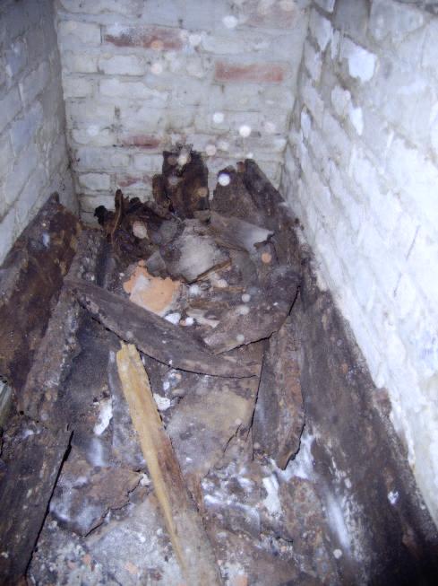
11 Church of St Mary-le-More, Wallingford, Oxfordshire v The most ornate vault (105) was previously observed in the 1995 watching brief (Fig. 2; Plate 5). It comprised a red brick vault measuring over 2 m by 2 m, but possibly truncated by later heating ducts, with a flight of five brick built steps measuring 1 m long, 0.25 m wide and 0.2 m high. A roughly dressed limestone slab blocked the entrance to the vault and bore the inscription: W, VII, NT, probably a mason's mark (Plate 6) A rectangular west-east aligned, brick vault (122) was located in the west end of the north aisle. The structure was trench built and measured 1.95 m x 0.75 m x 0.94 m with a low barrel vaulted top (Fig. 2; Plate 7). The remains of a coffin were present within the vault, which were overlain by the curved wooden frame used to construct the vault's roof (Plate 8) Two trenches were excavated through the floor of the Rector's Office to enable column supports to be constructed. The collapsed east end of a brick vault (118) was revealed within the southern trench; the vault was backfilled by loose brick rubble (Fig. 2; Plate 9) A vault (124) was revealed outside the north porch of the church during the construction of a wheel chair ramp (Fig. 2; Plate 10). The vault was intact and measured over 2.30 m long and 1.20 m wide. It was constructed from red bricks measuring 0.22 m x 0.11 m x 0.07 m in a yellowish sandy mortar bond. The vault was overlain by a 0.45 m thick buried graveyard soil and the stone paving of the existing church path. 19th-century heating ducts Three east-west aligned brick lined heating ducts ( ) were revealed within the centre of the church (Fig. 2; Plate 11). The ducts connected to a north-south aligned duct (106), which led from the boiler room. The structures were over 7 m long and 1.2 m wide, and were constructed from two brick walls, each four courses high and overlain by a course of peg tiles. The bricks measured 0.22 m by 0.08 m by 0.07 m and the base of each duct was constructed from limestone slabs. Where ducts 104 and 106 joined, an upper stone floor was inserted, presumably to aid circulation of the warm air (Plate 12). Other deposits A north-south aligned wall foundation was revealed within an excavation for a service trench to the east of the pulpit. The foundation (110) was was constructed from rough limestone blocks and measured 0.7 m wide and over 0.2 m deep (Fig. 2; Plate 13). It is possible that the wall formed part of the medieval church, but the absence of flint and its location directly beneath the vestry door is makes a 19th-century date more likely. The structure probably formed a foundation for the vestry wall In the north west corner of the church was a flint pebble hardcore base (123) for the construction of the present staircase. The spread measured 4m x 2 m (Fig. 2) A service trench was excavated around the north side of the church. The trench was 0.40 m wide and 0.60 m in depth and was cut through a 0.45 m thick buried soil (112; Fig. 2). This soil had been cut by a construction trench (114) for an old boundary wall (113), the trench measured 0.45 m wide and 0.50 m deep and the wall footing was constructed of chalk fragments in a light brown clay bond (Plate 14). Only the top of the wall foundation was observed and it was overlain by a light brown silty sand backfill (115). The deposits were overlain by the existing stone surface of the churchyard (111). Oxford Archaeology Page 7 of 12 February 2010
12 Church of St Mary-le-More, Wallingford, Oxfordshire v Finds summary John Cotter (OA) identified the pottery and ceramic building material recovered from the site, which included a fragment of a 13th- to 15th-century Brill/Boarstall ware jug base from levelling layer 107, and seven fragments of late medieval or post-medieval peg tiles that were used to level up the top course of the 19th-century heating ducts (101) Ian Scott (OA) identified an 18th- to 19th-century moulded glass bottle recovered from levelling layer Palaeo-environmental remains No deposits suitable for environmental sampling were identified during the watching brief. Oxford Archaeology Page 8 of 12 February 2010
13 Church of St Mary-le-More, Wallingford, Oxfordshire v.1 4 DISCUSSION The relatively shallow depth of the groundworks meant that no new sections of the medieval church were observed. A rubbly levelling deposit, at least 0.6 m thick, was observed throughout the church and either obscured medieval floors and walls or filled voids following the removal of medieval structures. A 15 m section of the south wall of the medieval church was seen, but no new light could be shed on the results of the 1995 watching brief A total of seven brick-built vaults were revealed within the church, and one vault was revealed outside the church's north entrance. The vaults' roofs were all barrel shaped but the vaults varied in size from single shaft graves, to sizeable structures capable of containing several individuals. A stairway led to the base of vault 105, and it is feasible that the chamber was used for several generations. As ground reduction varied within the church it is possible that vaults may survive elsewhere It is unclear whether the vaults pre-dated the deposition of levelling layer 107, but vault 100, the resting place of Sarah and William Sheen, was constructed in 1833 and the brick vaults and levelling layer are likely to be broadly contemporary The heating ducts were cut through the levelling deposits and truncated two of the brick vaults. The ducts were constructed so that a double shaft fed the three central ducts of the heating system. Presumably if only a single shaft fed the three ducts the system would have been less efficient A small section of an undated boundary wall was revealed within the northern churchyard, and it is likely that the church boundary was altered to match the existing road layout. Oxford Archaeology Page 9 of 12 February 2010
14 Church of St Mary-le-More, Wallingford, Oxfordshire v.1 APPENDIX A. CONTEXT INVENTORY Context Type Depth (m) Width (m) Length (m) Comments 100 Slab Grave marker 101 Structure South wall of medieval church 102 Structure th Century heating duct 103 Structure th Century heating duct 104 Structure th Century heating duct 105 Structure Brick vault 106 Structure th Century heating duct 107 Layer 0.6 Construction layer 108 Cut Vault/Grave cut 109 Fill Fill of Structure Foundation wall 111 Layer 0.15 Stone surface in front of church 112 Layer 0.45 Old graveyard soil 113 Structure 0.6 Foundation of churchyard wall 114 Cut Construction trench 115 Fill Backfill of trench Cut Test pit 117 Layer Construction layer in church 118 Structure Brick vault 119 Fill Backfill of vault 120 Cut Test pit 121 Structure 0.8 Brick divider wall of vault 122 Structure Brick vault 123 Layer Hardcore floor make up 124 Structure Brick vault Oxford Archaeology Page 10 of 12 February 2010
15 Church of St Mary-le-More, Wallingford, Oxfordshire v.1 APPENDIX B. BIBLIOGRAPHY AND REFERENCES Geological Survey of Great Britain, Sheet No 254, 1:50,000 OAU, 1995 Church of St Mary-Le-More, Wallingford, Oxfordshire Archaeological Watching Brief, unpublished client report Oxford Diocese, 2008 St Mary Le More Church, Wallingford, (Archdeaconry of Berkshire: Deanery of Wallingford), Archaeological Recording Specification, unpublished client report Wilkinson, D (ed.), 1992 OAU Fieldwork Manual, unpublished report Oxford Archaeology Page 11 of 12 February 2010
16 Church of St Mary-le-More, Wallingford, Oxfordshire v.1 APPENDIX C. SUMMARY OF SITE DETAILS Site name: Site code: WALMOM 09 Grid reference: NGR SU Type: Church of St Mary-le-More, Wallingford, Oxfordshire Watching Brief Date and duration: 8/6/2009 to 2/12/ a total of 8 site visits were made during the course of the ground works. Area of site: 28.5 m x 18 m Summary of results: The watching brief revealed the south wall of the medieval church, brick lined vaults and a 19th-century church heating system. Location of archive: The archive is currently held at OA, Janus House, Osney Mead, Oxford, OX2 0ES, and will be deposited with Oxfordshire County Museums Service in due course, under the following accession number: OXCMS Oxford Archaeology Page 12 of 12 February 2010


17 Servergo:/oaupubs1_RthuZ*WALMOM09*WALMOMWB*ST MARYS CHURCH*MRG* NORWICH BIRMINGHAM OXFORD F LONDON R N Site location Reproduced from the Landranger 1:50,000 scale by permission of the Ordnance Survey on behalf of The Controller of Her Majesty's Stationery Office Crown Copyright All rights reserved. Licence No. AL Figure 1: Site location
18
19 Servergo:/oaupubs1_RthuZ*WALMOM09*WALMOMWB*ST MARYS CHURCH*MRG* N Section 1 S E N W mod Section m : Boiler room Rectors Office Chancel Key 19th Century wall footings Pulpit 19th Century heating duct base 19th Century heating duct walls Bricklined vault 102 Medieval church walls 101 Test pit Test pit 110 Services 100 Underground vaults Old Choir Vestry 0 5 m 1:150 Figure 2: Site plan showing archaeological features and Section 1
20


21 Servergo:/oaupubs1_RthuZ*WALMOM09*WALMOMWB*ST MARYS CHURCH*MRG* Wall 101 Plate 1: Medieval church wall 101, western section looking south Wall 101 Plate 2: Medieval church wall 101, looking east Plates 1 and 2
22
23 Servergo:/oaupubs1_RthuZ*WALMOM09*WALMOMWB*ST MARYS CHURCH*MRG* Plate 3: Grave marker 100 Plate 4: Vault 121, looking north Plates 3 and 4
24


25 Servergo:/oaupubs1_RthuZ*WALMOM09*WALMOMWB*ST MARYS CHURCH*MRG* Plate 5: Brick vault 105, looking north-east Mason s mark Plate 6: Brick vault 105 Mason s mark Plates 5 and 6
26
27 Servergo:/oaupubs1_RthuZ*WALMOM09*WALMOMWB*ST MARYS CHURCH*MRG* Plate 7: Brick vault 122, looking south Plate 8: Brick vault 122, internal view Plates 7 and 8
28
29 Servergo:/oaupubs1_RthuZ*WALMOM09*WALMOMWB*ST MARYS CHURCH*MRG* Plate 9: Brick vault 118, looking west Plate 10: Brick vault 124, looking west Plates 9 and 10
30


31 Servergo:/oaupubs1_RthuZ*WALMOM09*WALMOMWB*ST MARYS CHURCH*MRG* Plate 11: Brick heating duct 102, looking east 106 Plate 12: Brick heating duct 106, looking west Plates 11 and 12
32


33 Servergo:/oaupubs1_RthuZ*WALMOM09*WALMOMWB*ST MARYS CHURCH*MRG* Plate 13: Vestry wall foundation 110, looking west 113 Plate 14: Wall footing 113, looking south Plates 13 and 14
34
35
36
Church of St Peter and St Paul, Great Missenden, Buckinghamshire
 Church of St Peter and St Paul, Great Missenden, Buckinghamshire An Archaeological Watching Brief for the Parish of Great Missenden by Andrew Taylor Thames Valley Archaeological Services Ltd Site Code
Archaeological. Monitoring & Recording Report. Fulbourn Primary School, Cambridgeshire. Archaeological Monitoring & Recording Report.
 Fulbourn Primary School, Cambridgeshire Archaeological Monitoring & Recording Report October 2014 Client: Cambridgeshire County Council OA East Report No: 1689 OASIS No: oxfordar3-192890 NGR: TL 5190 5613
New Composting Centre, Ashgrove Farm, Ardley, Oxfordshire
 New Composting Centre, Ashgrove Farm, Ardley, Oxfordshire An Archaeological Watching Brief For Agrivert Limited by Andrew Weale Thames Valley Archaeological Services Ltd Site Code AFA 09/20 August 2009
Greater London GREATER LONDON 3/606 (E ) TQ
 TQ") GREATER LONDON City of London 3/606 (E.01.6024) TQ 30358150 1 PLOUGH PLACE, CITY OF LONDON An Archaeological Watching Brief at 1 Plough Place, City of London, London EC4 Butler, J London : Pre-Construct
GREATER LONDON City of London 3/606 (E.01.6024) TQ 30358150 1 PLOUGH PLACE, CITY OF LONDON An Archaeological Watching Brief at 1 Plough Place, City of London, London EC4 Butler, J London : Pre-Construct
An archaeological watching brief at St Leonard s church, Hythe Hill, Colchester, Essex
 An archaeological watching brief at St Leonard s church, Hythe Hill, Colchester, Essex report prepared by Adam Wightman on behalf of Dorvell Construction CAT project ref.: 10/5d Colchester and Ipswich
2 Saxon Way, Old Windsor, Berkshire
 2 Saxon Way, Old Windsor, Berkshire An Archaeological Watching Brief For Mrs J. McGillicuddy by Pamela Jenkins Thames Valley Archaeological Services Ltd Site Code SWO 05/67 August 2005 Summary Site name:
An archaeological watching brief and recording at Brightlingsea Quarry, Moverons Lane, Brightlingsea, Essex October 2003
 An archaeological watching brief and recording at Brightlingsea Quarry, Moverons Lane, Brightlingsea, Essex commissioned by Mineral Services Ltd on behalf of Alresford Sand & Ballast Co Ltd report prepared
An archaeological evaluation at 16 Seaview Road, Brightlingsea, Essex February 2004
 An archaeological evaluation at 16 Seaview Road, Brightlingsea, Essex February 2004 report prepared by Kate Orr on behalf of Highfield Homes NGR: TM 086 174 (c) CAT project ref.: 04/2b ECC HAMP group site
Silwood Farm, Silwood Park, Cheapside Road, Ascot, Berkshire
 Silwood Farm, Silwood Park, Cheapside Road, Ascot, Berkshire An Archaeological Watching Brief For Imperial College London by Tim Dawson Thames Valley Archaeological Services Ltd Site Code SFA 09/10 April
ARCHAEOLOGICAL S E R V I C E S. St Nicholas' Church, Barrack Hill, Nether Winchendon, Buckinghamshire. Archaeological Watching Brief.
 T H A M E S V A L L E Y ARCHAEOLOGICAL S E R V I C E S St Nicholas' Church, Barrack Hill, Nether Winchendon, Buckinghamshire Archaeological Watching Brief by Steven Crabb Site Code: STW17/229 (SP 7735
Archaeological Evaluation Report
 16-18 Church Street Brill Buckinghamshire o a February 2008 Client: Stephen Moss Developments Issue N o : 1 OA Job N o : 3858 Planning Ref N o : 06/01304 NGR: SP 6553 1377 Client Name: Stephen Moss Developments
Grim s Ditch, Starveall Farm, Wootton, Woodstock, Oxfordshire
 Grim s Ditch, Starveall Farm, Wootton, Woodstock, Oxfordshire An Archaeological Recording Action For Empire Homes by Steve Ford Thames Valley Archaeological Services Ltd Site Code SFW06/118 November 2006
Archaeological evaluation at the Onley Arms, The Street, Stisted, Essex
 Archaeological evaluation at the Onley Arms, The Street, Stisted, Essex November 2014 report by Pip Parmenter and Adam Wightman with a contribution from Stephen Benfield and illustrations by Emma Holloway
An archaeological evaluation at the Blackwater Hotel, Church Road, West Mersea, Colchester, Essex March 2003
 An archaeological evaluation at the Blackwater Hotel, Church Road, West Mersea, Colchester, Essex report prepared by Laura Pooley on behalf of Dolphin Developments (U.K) Ltd NGR: TM 0082 1259 CAT project
Monitoring Report No. 99
 Monitoring Report No. 99 Enniskillen Castle Co. Fermanagh AE/06/23 Cormac McSparron Site Specific Information Site Name: Townland: Enniskillen Castle Enniskillen SMR No: FER 211:039 Grid Ref: County: Excavation
Former Whitbread Training Centre Site, Abbey Street, Faversham, Kent Interim Archaeological Report Phase 1 November 2009
 Former Whitbread Training Centre Site, Abbey Street, Faversham, Kent Interim Archaeological Report Phase 1 November 2009 SWAT. Archaeology Swale and Thames Archaeological Survey Company School Farm Oast,
Archaeological Watching Brief (Phase 2) at Court Lodge Farm, Aldington, near Ashford, Kent December 2011
 at Court Lodge Farm, Aldington, near Ashford, Kent December 2011") Archaeological Watching Brief (Phase 2) at Court Lodge Farm, Aldington, near Ashford, Kent December 2011 SWAT. Archaeology Swale and Thames Archaeological Survey Company School Farm Oast, Graveney Road
Archaeological Watching Brief (Phase 2) at Court Lodge Farm, Aldington, near Ashford, Kent December 2011 SWAT. Archaeology Swale and Thames Archaeological Survey Company School Farm Oast, Graveney Road
ARCHAEOLOGICAL MONITORING REPORT
 ARCHAEOLOGICAL MONITORING REPORT SCCAS REPORT No. 2009/324 Thorington Hall, Stoke by Nayland SBN 087 HER Information Date of Fieldwork: November 2009 - January 2010 Grid Reference: TM 0131 3546 Funding
Peace Hall, Sydney Town Hall Results of Archaeological Program (Interim Report)
") Results of Archaeological Program (Interim Report) Background The proposed excavation of a services basement in the western half of the Peace Hall led to the archaeological investigation of the space in
Results of Archaeological Program (Interim Report) Background The proposed excavation of a services basement in the western half of the Peace Hall led to the archaeological investigation of the space in
39, Walnut Tree Lane, Sudbury (SUY 073) Planning Application No. B/04/02019/FUL Archaeological Monitoring Report No. 2005/112 OASIS ID no.
 Planning Application No. B/04/02019/FUL Archaeological Monitoring Report No. 2005/112 OASIS ID no.") 39, Walnut Tree Lane, Sudbury (SUY 073) Planning Application No. B/04/02019/FUL Archaeological Monitoring Report No. 2005/112 OASIS ID no. 9273 Summary Sudbury, 39, Walnut Tree Lane, Sudbury (TL/869412;
39, Walnut Tree Lane, Sudbury (SUY 073) Planning Application No. B/04/02019/FUL Archaeological Monitoring Report No. 2005/112 OASIS ID no. 9273 Summary Sudbury, 39, Walnut Tree Lane, Sudbury (TL/869412;
Folkestone Warren High Cliff Instrumentation Kent Archaeological Watching Brief Report. Client: Costain. March 2017
 Folkestone Warren High Cliff Instrumentation Kent Archaeological Watching Brief Report March 2017 Client: Costain Issue No: v1.0 OA Reference No: 6551 NGR: TR 2590 3850 Folkestone Warren High Cliff Instrumentation,
ARCHAEOLOGICAL EVALUATION AT BRIGHTON POLYTECHNIC, NORTH FIELD SITE, VARLEY HALLS, COLDEAN LANE, BRIGHTON. by Ian Greig MA AIFA.
 ARCHAEOLOGICAL EVALUATION AT BRIGHTON POLYTECHNIC, NORTH FIELD SITE, VARLEY HALLS, COLDEAN LANE, BRIGHTON by Ian Greig MA AIFA May 1992 South Eastern Archaeological Services Field Archaeology Unit White
An archaeological evaluation in the playground of Colchester Royal Grammar School, Lexden Road, Colchester, Essex
 An archaeological evaluation in the playground of Colchester Royal Grammar School, Lexden Road, Colchester, Essex February 2002 on behalf of Roff Marsh Partnership CAT project code: 02/2c Colchester Museum
An archaeological evaluation at the Lexden Wood Golf Club (Westhouse Farm), Lexden, Colchester, Essex
, Lexden, Colchester, Essex") An archaeological evaluation at the Lexden Wood Golf Club (Westhouse Farm), Lexden, Colchester, Essex January 2000 Archive report on behalf of Lexden Wood Golf Club Colchester Archaeological Trust 12 Lexden
An archaeological evaluation at the Lexden Wood Golf Club (Westhouse Farm), Lexden, Colchester, Essex January 2000 Archive report on behalf of Lexden Wood Golf Club Colchester Archaeological Trust 12 Lexden
Greater London Region GREATER LONDON 3/567 (E.01.K099) TQ BERMONDSEY STREET AND GIFCO BUILDING AND CAR PARK
 TQ BERMONDSEY STREET AND GIFCO BUILDING AND CAR PARK") GREATER LONDON 3/567 (E.01.K099) TQ 33307955 156-170 BERMONDSEY STREET AND GIFCO BUILDING AND CAR PARK Assessment of an Archaeological Excavation at 156-170 Bermondsey Street and GIFCO Building and Car
GREATER LONDON 3/567 (E.01.K099) TQ 33307955 156-170 BERMONDSEY STREET AND GIFCO BUILDING AND CAR PARK Assessment of an Archaeological Excavation at 156-170 Bermondsey Street and GIFCO Building and Car
FURTHER MIDDLE SAXON EVIDENCE AT COOK STREET, SOUTHAMPTON (SOU 567)
") Roc. Hampshire Field Club Archaeol. Soc 52,1997, 77-87 (Hampshire Studies 1997) FURTHER MIDDLE SAXON EVIDENCE AT COOK STREET, SOUTHAMPTON (SOU 567) By M F GARNER andj VINCENT with a contribution byjacqueline
Roc. Hampshire Field Club Archaeol. Soc 52,1997, 77-87 (Hampshire Studies 1997) FURTHER MIDDLE SAXON EVIDENCE AT COOK STREET, SOUTHAMPTON (SOU 567) By M F GARNER andj VINCENT with a contribution byjacqueline
Moated Site at Manor Farm, Islip, Oxfordshire
 Moated Site at Manor Farm, Islip, Oxfordshire An Archaeological Excavation By Jo Pine Site Code MFI05 December 2007 Summary Site name: Moated Site at Manor Farm, Islip, Oxfordshire Grid reference: SP 5298
Archaeological Services - Urban & Rural
 Report on an Archaeological Watching Brief at St. Mary s Church, Watton, Norfolk NHER 8795 Prepared for: Watton Parochial Church Council c/o St. Mary's Church Watton, Thetford, Norfolk IP25 6DQ Reference
E x cav atio n R e p o r t
 Medieval Trackway on land at Ivy Farm Royston, Hertfordshire Excavation Report E x cav atio n R e p o r t October 2011 Client: CgMs Consulting OA East Report No: 1305 OASIS No: oxfordar3-112012 NGR: TL
Archaeological Evaluation at Alconbury Weald Enterprise Zone
 Archaeological Evaluation at Alconbury Weald Enterprise Zone Archaeological Evaluation Report June 2015 Client: CgMS OA East Report No: 1768 OASIS No: oxfordar3-212519 NGR: TL 1975 7684 Archaeological
Essex Historic Environment Record/ Essex Archaeology and History
 Essex Historic Environment Record/ Essex Archaeology and History CAT Report 578 Summary sheet Address: Kingswode Hoe School, Sussex Road, Colchester, Essex Parish: Colchester NGR: TL 9835 2528 Type of
Grange Farm, Widmer End, Hughenden, Buckinghamshire
 Grange Farm, Widmer End, Hughenden, Buckinghamshire An Archaeological Evaluation for British Flora by Andy Taylor Thames Valley Archaeological Services Ltd Site Code GFH 05/63 July 2005 Summary Site name:
An archaeological evaluation by trial-trenching at Playgolf, Bakers Lane, Westhouse Farm, Colchester, Essex
 An archaeological evaluation by trial-trenching at Playgolf, Bakers Lane, Westhouse Farm, Colchester, Essex commissioned by Mr Stephen Belchem on behalf of ADP Ltd. report prepared by Chris Lister Planning
Monitoring Report No Sacred Heart Church Aghamore Boho Co. Fermanagh AE/10/116E. Brian Sloan L/2009/1262/F
 Monitoring Report No. 202 Sacred Heart Church Aghamore Boho Co. Fermanagh AE/10/116E Brian Sloan L/2009/1262/F Site Specific Information Site Address: Sacred Heart Church, Aghamore, Boho, Co. Fermanagh
3. The new face of Bronze Age pottery Jacinta Kiely and Bruce Sutton
 3. The new face of Bronze Age pottery Jacinta Kiely and Bruce Sutton Illus. 1 Location map of Early Bronze Age site at Mitchelstown, Co. Cork (based on the Ordnance Survey Ireland map) A previously unknown
S E R V I C E S. St John the Baptist Church, Penshurst, Kent. Archaeological Watching Brief. by Daniel Bray and James McNicoll-Norbury
 T H A M E S V A L L E Y ARCHAEOLOGICAL S E R V I C E S St John the Baptist Church, Penshurst, Kent Archaeological Watching Brief by Daniel Bray and James McNicoll-Norbury Site Code: JPK11/25 (TQ 5273 4385)
An archaeological watching brief on one section of an Anglian Water main Spring Lane, Lexden, Colchester
 An archaeological watching brief on one section of an Anglian Water main Spring Lane, Lexden, Colchester April-September 2001 on behalf of Breheny Contractors CAT project ref.: 01/4D Colchester Museum
Land North of Pesthouse Lane Barham Suffolk BRH 054
 Land North of Pesthouse Lane Barham Suffolk BRH 054 Archaeological Evaluation Report SCCAS Report No. 2012/142 Client: Barham Parish Council Author: Jezz Meredith September 2012 SCCAS Land North of Pesthouse
1 The East Oxford Archaeology and History Project
 1 The East Oxford Archaeology and History Project EXOP TEST PIT 72 Location: Bartlemas Chapel, Cowley Date of excavation: 6-8 November 2013. Area of excavation: 0.8m x 1.2m, at the eastern end of the chapel.
Colchester Archaeological Trust Ltd. A Fieldwalking Survey at Birch, Colchester for ARC Southern Ltd
 Colchester Archaeological Trust Ltd A Fieldwalking Survey at Birch, Colchester for ARC Southern Ltd November 1997 CONTENTS page Summary... 1 Background... 1 Methods... 1 Retrieval Policy... 2 Conditions...
Excavation. Post-Medieval Ditches. Land off Norwich Common Road Wymondham Norfolk. Excavation. Client: November 2013
 Land off Norwich Common Road Wymondham Norfolk. Excavation November 2013 Client: OA East Report No: 1546 OASIS No: oxfordar3-163105 NGR: TG 12770 02684 Excavation Post-Medieval Ditches Post-Medieval Ditches
7. Prehistoric features and an early medieval enclosure at Coonagh West, Co. Limerick Kate Taylor
 7. Prehistoric features and an early medieval enclosure at Coonagh West, Co. Limerick Kate Taylor Illus. 1 Location of the site in Coonagh West, Co. Limerick (based on the Ordnance Survey Ireland map)
Former Filling Station, High Street, Dorchester-on-Thames, Oxfordshire
 Former Filling Station, High Street, Dorchester-on-Thames, Oxfordshire An Archaeological Evaluation for Country Visions OK Limited by Sarah Coles Thames Valley Archaeological Services Ltd Site Code HSD01/36
Archaeological trial-trenching evaluation at Chappel Farm, Little Totham, Essex. April 2013
 Archaeological trial-trenching evaluation at Chappel Farm, Little Totham, Essex April 2013 report prepared by Ben Holloway commissioned by Tim Harbord Associates on behalf of Mr Tom Howie Planning reference:
THE PRE-CONQUEST COFFINS FROM SWINEGATE AND 18 BACK SWINEGATE
 THE PRE-CONQUEST COFFINS FROM 12 18 SWINEGATE AND 18 BACK SWINEGATE An Insight Report By J.M. McComish York Archaeological Trust for Excavation and Research (2015) Contents 1. INTRODUCTION... 3 2. THE
C o w e s. Isle of Wight. BAE Systems Land. Archaeological Evaluation Report. Client: BAE Systems. November 2008
 BA Systems Land C o w e s Isle of ight Archaeological valuation Report November 2008 Client: BA Systems Issue No: 1 OA Job No: 4253 NGR: SZ 489 453 Archaeological valuation Report Client Name: BA Systems
Wantage County Primary School, Garston Lane, Wantage, Oxfordshire
 Wantage County Primary School, Garston Lane, Wantage, Oxfordshire An Archaeological Evaluation for Oxfordshire County Council by Erlend Hindmarch Thames Valley Archaeological Services Ltd Site Code GLW
Eton College Courtyard Resurfacing Work, Windsor, Berkshire Archaeological Watching Brief Report. Client: Eton College. March 2017
 Eton College Courtyard Resurfacing Work, Windsor, Berkshire Archaeological Watching Brief Report March 2017 Client: Eton College Issue No: 1 OA Reference No: ETONSWB2 NGR: SU 96701 77909 Client Name:
An archaeological evaluation by trial-trenching at Scotts Farm, Lodge Lane, Purleigh, Essex October 2011
 An archaeological evaluation by trial-trenching at Scotts Farm, Lodge Lane, Purleigh, Essex October 2011 report prepared by Adam Wightman on behalf of Richard Emans CAT project ref.: 11/10a NGR: TL 582719
An archaeological watching brief at Sheepen, Colchester, Essex November-December 2003
 An archaeological watching brief at Sheepen, Colchester, Essex November-December 2003 report prepared by Ben Holloway on behalf of Colchester Borough Council CAT project ref.: 03/11c Colchester Museums
A visit to the Wor Barrow 21 st November 2015
 A visit to the Wor Barrow 21 st November 2015 Following our exploration of Winkelbury a few weeks previously, we fast forwarded 12 years in Pitt Rivers remarkable series of excavations and followed him
Test-Pit 3: 31 Park Street (SK )
") -Pit 3: 31 Park Street (SK 40732 03178) -Pit 3 was excavated in a flower bed in the rear garden of 31 Park Street, on the northern side of the street and west of an alleyway leading to St Peter s Church,
-Pit 3: 31 Park Street (SK 40732 03178) -Pit 3 was excavated in a flower bed in the rear garden of 31 Park Street, on the northern side of the street and west of an alleyway leading to St Peter s Church,
Archaeological Watching Brief Report
 Hampton Court Palace Signage Archaeological Watching Brief Report February 2011 Client: Historic Royal Palaces Issue No: 1 OA Job No: 4371 NGR: TQ 1560 6870 Archaeological Watching Brief Report Servergo:/oaupubs1_AthuH*HCP53*HCP53BS*Hampton
Wandsworth London. Alma Tavern. o a. A rch aeol ogi cal I nvestigation R eport. Client: Young s and Co. Brewery Plc and Nickless Allen.
 Alma Tavern Wandsworth London Archaeological Investigation Report o a April 2010 Client: Young s and Co. Brewery Plc and Nickless Allen Issue No: 1 NGR: TQ 260 750 A rch aeol ogi cal I nvestigation R eport
TIPPERARY HISTORICAL JOURNAL 1994
 TPPERARY HSTORCAL JOURNAL 1994 County Tipperary Historical Society www.tipperarylibraries.ie/ths society@tipperarylibraries. ie SSN 0791-0655 Excavations at Cormac's Chapel, Cashel, 1992 and 1993: a preliminary
Small Finds Assessment, Minchery Paddock, Littlemore, Oxford (MP12)
") Small s Assessment, Minchery Paddock, Littlemore, Oxford (MP12) Introduction A total of 51 objects recovered from excavations at Minchery Paddock, Littlemore, Oxford (MP12) were submitted for dating and
Small s Assessment, Minchery Paddock, Littlemore, Oxford (MP12) Introduction A total of 51 objects recovered from excavations at Minchery Paddock, Littlemore, Oxford (MP12) were submitted for dating and
Old Brewery Close and Walton Street, Aylesbury, Buckinghamshire
 Old Brewery Close and Walton Street, Aylesbury, Buckinghamshire An Archaeological Evaluation for Berkeley Homes (Oxford and Chiltern) Ltd by Sian Anthony Thames Valley Archaeological Services Ltd Site
TOTTENHAM COURT ROAD CROSSRAIL EASTERN TICKET HALL 12 Goslett Yard London WC2
 TOTTENHAM COURT ROAD CROSSRAIL EASTERN TICKET HALL 12 Goslett Yard London WC2 City of Westminster A targeted watching brief report November 2010 Museum of London 2010 Site code: TCG 09 NGR: 529810 181260
Erection of wind turbine, Mains of Loanhead, Old Rayne, AB52 6SX
 Erection of wind turbine, Mains of Loanhead, Old Rayne, AB52 6SX Ltd 23 November 2011 Erection of wind turbine, Mains of Loanhead, Old Rayne, AB52 6SX CONTENTS 1 INTRODUCTION 3 2 ARCHAEOLOGICAL BACKGROUND
EVALUATION REPORT No. 273
 EVALUATION REPORT No. 273 Freeduff Presbyterian Church, 3 Oldtown road, Freeduff, Cullyhanna, County Armagh Licence No.: AE/13/133E Sapphire Mussen Report Date: 20/09/2013 Contents List of Figures... 2
Centre for Archaeological Fieldwork,
 Centre for Archaeological Fieldwork, School of Geography, Archaeology and Palaeoecology, Queen s University Belfast Data Structure Report No. 70 (preliminary report) Archaeological Excavations at Carrickfergus
Undley Hall, Lakenheath LKH 307
 ARCHAEOLOGICAL EVALUATION AND MONITORING REPORT SCCAS REPORT No. 2010/005 Undley Hall, Lakenheath LKH 307 E. Muldowney SCCAS January 2010 www.suffolkcc.gov.uk/e-and-t/archaeology Lucy Robinson, County
BLEA TARN ROAD PIPELINE REPLACEMENT, LANCASTER, LANCASHIRE
 BLEA TARN ROAD PIPELINE REPLACEMENT, LANCASTER, LANCASHIRE Archaeological Watching Brief Report Oxford Archaeology North July 2006 RSK ENSR Environmental Ltd Issue No: 2006-7/538 OA North Job No: L9683
Centre for Archaeological Fieldwork School of Geography, Archaeology and Palaeoecology Queen s University Belfast
 Centre for Archaeological Fieldwork School of Geography, Archaeology and Palaeoecology Queen s University Belfast Data Structure Report: No. 053 Excavations at Dunseverick Cave, Feigh alias Dunseverick,
39 & 41 MEDINA AVENUE, NEWPORT, ISLE OF WIGHT AN ARCHAEOLOGICAL EVALUATION REPORT. Planning Application Ref: Pre-Application
 39 & 41 MEDINA AVENUE, NEWPORT, ISLE OF WIGHT AN ARCHAEOLOGICAL EVALUATION REPORT National Grid Reference: SZ 5025 8861 Planning Application Ref: Pre-Application By: AOC ARCHAEOLOGY GROUP Commissioned
17 Phase 5. High and Late medieval features and activities AD
 17 Phase 5. High and Late medieval features and activities 1200 1550 AD 17.1 Results This time phase is based on all findings that can be placed in the High and Late medieval period 1200 1550 AD based
Archaeological sites and find spots in the parish of Burghclere - SMR no. OS Grid Ref. Site Name Classification Period
 Archaeological sites and find spots in the parish of Burghclere - SMR no. OS Grid Ref. Site Name Classification Period SU45NE 1A SU46880 59200 Ridgemoor Farm Inhumation Burial At Ridgemoor Farm, on the
An archaeological watching brief and evaluation at Great Notley business park, near Braintree, Essex June-September 2005
 An archaeological watching brief and evaluation at Great Notley business park, near Braintree, Essex report prepared by Kate Orr commissioned by Andrew Martin Associates Ltd on behalf of Countryside Properties
Suburban life in Roman Durnovaria
 Suburban life in Roman Durnovaria Additional specialist report Finds Ceramic building material By Kayt Brown Ceramic building material (CBM) Kayt Brown A total of 16420 fragments (926743g) of Roman ceramic
EXCAVATION AT ST MARY'S ROAD, SOUTHAMPTON (SOU 379 AND SOU 1112)
") Proc. Hampshire Field Club Archaeol. Soc. 58, 2003, 106-129 (Hampshire Studies 2003) EXCAVATION AT ST MARY'S ROAD, SOUTHAMPTON (SOU 379 AND SOU 1112) By M F GARNER With contributions ^DM GOODBURN and L
Proc. Hampshire Field Club Archaeol. Soc. 58, 2003, 106-129 (Hampshire Studies 2003) EXCAVATION AT ST MARY'S ROAD, SOUTHAMPTON (SOU 379 AND SOU 1112) By M F GARNER With contributions ^DM GOODBURN and L
AN ARCHAEOLOGICAL EVALUATION AT CAISTOR ST EDMUND CHURCHYARD, NORFOLK
 AN ARCHAEOLOGICAL EVALUATION AT CAISTOR ST EDMUND CHURCHYARD, NORFOLK John W Percival November 2009 An Archaeological Evaluation at Caistor St Edmund Churyard, Norfolk NLA Reference CNF42347 John W. Percival
The Swan Hotel, Lavenham LVM 080
 The Swan Hotel, Lavenham LVM 080 Post-Excavation Assessment Report v0.4 SCCAS Report No. 2013/148 Client: TA Hotel Collection Author: Rob Brooks December/2014 Suffolk County Council Archaeological Service
An archaeological evaluation at Thistle Hall, Mope Lane, Wickham Bishops, Essex July 2009
 An archaeological evaluation at Thistle Hall, Mope Lane, Wickham Bishops, Essex July 2009 report prepared by Howard Brooks and Ben Holloway on behalf of Clarity Ecoworks Ltd CAT project ref.: 09/1f ECC
Chapel House Wood Landscape Project. Interim Report 2013
 Chapel House Wood Landscape Project Interim Report 2013 Chapel House Wood Landscape Project Interim Report 2013 The annual Dales Heritage Field School was held at Chapel House Wood again this year, and
Data Structure Report: Boho High Cross, Toneel North, Co. Fermanagh
 Data Structure Report: Boho High Cross, Toneel North, Co. Fermanagh Colm Donnelly, Philip Macdonald, Eileen Murphy and Nicholas Beer SMR No: Ferm 210:14 Grid Reference: H1167 4621 Excavation Licence: AE/02/49
The Papar Project Hebrides
 The Papar Project Hebrides Barbara E. Crawford and Ian Simpson H1. Pabay/Pabaigh (Uig, Lewis) Parish History H2. Pabbay/Pabaigh (Harris) Ecclesiastical Monuments Other Archaeological Sites Fieldwork 2005
AN EARLY MEDIEVAL RUBBISH-PIT AT CATHERINGTON, HAMPSHIRE Bj>J. S. PILE and K. J. BARTON
 AN EARLY MEDIEVAL RUBBISH-PIT AT CATHERINGTON, HAMPSHIRE Bj>J. S. PILE and K. J. BARTON INTRODUCTION THE SITE (fig. 21) is situated in the village of Catherington, one mile north-west of Horndean and 200
Phase 1 Area: Somerville College, Walton Street, Oxford
 Phase 1 Area: Somerville College, Walton Street, Oxford Archaeological Evaluation Report July 2017 Client: Bidwells LLP for Somerville College Issue No: OA Reference No: OXSCWEV NGR: SP 5093 0689 Oxford
(photograph courtesy Earle Seubert)
") THE ARCHAEOLOGY OF A CEMETERY THE TRIALS AND TRIBULATIONS OF FINDING THE LOST GRAVES OF WOODMAN POINT QUARANTINE STATION This presentation is about a project initiated by the Friends of Woodman Point and
THE ARCHAEOLOGY OF A CEMETERY THE TRIALS AND TRIBULATIONS OF FINDING THE LOST GRAVES OF WOODMAN POINT QUARANTINE STATION This presentation is about a project initiated by the Friends of Woodman Point and
An archaeological excavation of test-holes at St Barnabas Church, Alphamstone, Essex March and May 2007
 An archaeological excavation of test-holes at St Barnabas Church, Alphamstone, Essex March and May 2007 report prepared by Kate Orr commissioned by David Whymark Building Design and Conservation on behalf
Evidence for the use of bronze mining tools in the Bronze Age copper mines on the Great Orme, Llandudno
 Evidence for the use of bronze mining tools in the Bronze Age copper mines on the Great Orme, Llandudno Background The possible use of bronze mining tools has been widely debated since the discovery of
Cambridge Archaeology Field Group. Fieldwalking on the Childerley Estate Cambridgeshire
 Cambridge Archaeology Field Group Fieldwalking on the Childerley Estate Cambridgeshire 2009 to 2014 Summary Fieldwalking on the Childerley estate of Martin Jenkins and Family has revealed, up to March
Museum of London Archaeological Archive: standards 2 Archive Components: Standards and Specifications 2.3 Finds
 Author Maloney, Cath. LAARC Version 3 Date 08/05/2013 Status Pre-publication Change History 2.9. Replacement of Registered Finds cards with image 2.3.4.3 2.8 Additions to Appendix: sample Finds Inventory
Warstone Lane catacombs
 Warstone Lane catacombs Recently, Shortie and Leslam investigated the Warstone Burial indices to try to identify certain grave numbers that do not appear on the grave plans. This was instigated by the
Land Adjacent 12 Stow Road, Ixworth IXW 063
 ARCHAEOLOGICAL MONITORING REPORT SCCAS REPORT No. 2010/128 Land Adjacent 12 Stow Road, Ixworth IXW 063 R. Brooks December 2010 www.suffolkcc.gov.uk/e-and-t/archaeology Lucy Robinson, County Director of
LAND WEST OF ELM GROVE, EBRINGTON, GLOUCESTERSHIRE. NGR: SP (centred) ARCHAEOLOGICAL EVALUATION
 ARCHAEOLOGICAL EVALUATION") LAND WEST OF ELM GROVE, EBRINGTON, GLOUCESTERSHIRE. NGR: SP 1892 4012 (centred) ARCHAEOLOGICAL EVALUATION Report No. 640 May 2009 1q LAND WEST OF ELM GROVE, EBRINGTON, GLOUCESTERSHIRE. NGR: SP 1892 4012
LAND WEST OF ELM GROVE, EBRINGTON, GLOUCESTERSHIRE. NGR: SP 1892 4012 (centred) ARCHAEOLOGICAL EVALUATION Report No. 640 May 2009 1q LAND WEST OF ELM GROVE, EBRINGTON, GLOUCESTERSHIRE. NGR: SP 1892 4012
Chapter 2. Remains. Fig.17 Map of Krang Kor site
 Chapter 2. Remains Section 1. Overview of the Survey Area The survey began in January 2010 by exploring the site of the burial rootings based on information of the rooted burials that was brought to the
Hayling School, Church Road, Hayling Island, Hampshire
 Hayling School, Church Road, Hayling Island, Hampshire An Archaeological Evaluation for George Wimpey Southern Ltd by Helen Moore Thames Valley Archaeological Services Ltd Site Code HSHI 03/46 July 2003
NORTH PENNINES ARCHAEOLOGY LTD
 NORTH PENNINES ARCHAEOLOGY LTD Client Report No. CP/446/07 Planning Reference: 2060799 NCCCT Reference: T13/23; 5982 OASIS Reference: northpen3-25609 Tony Liddell B.Sc. Nenthead Mines Heritage Centre Nenthead
Burials and Wall Foundations on the Site of Chatteris Abbey to the Rear of No. 19 Victoria Street Chatteris Cambridgeshire
 Burials and Wall Foundations on the Site of Chatteris Abbey to the Rear of No. 19 Victoria Street Chatteris Cambridgeshire Archaeological Evaluation Report August 2011 Client: Ian Moore OA East Report
Cambridge Archaeology Field Group. Fieldwalking on the Childerley Estate, Cambridgeshire. Autumn 2014 to Spring Third interim report
 Cambridge Archaeology Field Group Fieldwalking on the Childerley Estate, Cambridgeshire Autumn 2014 to Spring 2015 Third interim report Summary Field walking on the Childerley estate of Martin Jenkins
WESTSIDE CHURCH (TUQUOY)
") Property in Care (PIC) ID: PIC324 Designations: Scheduled Monument (SM90312) Taken into State care: 1933 (Guardianship) Last reviewed: 2004 HISTORIC ENVIRONMENT SCOTLAND STATEMENT OF SIGNIFICANCE WESTSIDE
Property in Care (PIC) ID: PIC324 Designations: Scheduled Monument (SM90312) Taken into State care: 1933 (Guardianship) Last reviewed: 2004 HISTORIC ENVIRONMENT SCOTLAND STATEMENT OF SIGNIFICANCE WESTSIDE
MARSTON MICHAEL FARLEY
 MARSTON MICHAEL FARLEY On 9 March agricultural contractors, laying field drains for Bucks County Council Land Agent's Department, cut through a limestone structure at SP 75852301 in an area otherwise consistently
Archaeological Material From Spa Ghyll Farm, Aldfield
 Archaeological Material From Spa Ghyll Farm, Aldfield Introduction Following discussions with Linda Smith the Rural Archaeologist for North Yorkshire County Council, Robert Morgan of 3D Archaeological
16 members of the Fieldwalking Group met York Community Archaeologist Jon Kenny at Lou Howard s farm, Rose Cottage Farm, at
 Terrington History Group Fieldwalking Group Field 1 Final report 21 October 2011 - fieldwalking 16 members of the Fieldwalking Group met York Community Archaeologist Jon Kenny at Lou Howard s farm, Rose
December 6, Paul Racher (P007) Archaeological Research Associates Ltd. 900 Guelph St. Kitchener ON N2H 5Z6
 Archaeological Research Associates Ltd. 900 Guelph St. Kitchener ON N2H 5Z6") Ministry of Tourism, Culture and Sport Culture Programs Unit Programs and Services Branch Culture Division 401 Bay Street, Suite 1700 Toronto ON M7A 0A7 Tel.: 416-314-2120 Ministère du Tourisme, de la
Ministry of Tourism, Culture and Sport Culture Programs Unit Programs and Services Branch Culture Division 401 Bay Street, Suite 1700 Toronto ON M7A 0A7 Tel.: 416-314-2120 Ministère du Tourisme, de la
ROMAN AND MEDIEVAL ACTIVITY IN THE UPPER WALBROOK VALLEY: EXCAVATIONS AT MOORGATE, CITY OF LONDON, EC2, 1997
 ROMAN AND MEDIEVAL ACTIVITY IN THE UPPER WALBROOK VALLEY: EXCAVATIONS AT 12 18 MOORGATE, CITY OF LONDON, EC2, 1997 Graham Bruce, Dominic Perring, Tim Stevens and Melissa Melikian SUMMARY In January and
Excavations at Shikarpur, Gujarat
 Excavations at Shikarpur, Gujarat 2008-2009 The Department of Archaeology and Ancient History, the M. S. University of Baroda continued excavations at Shikarpur in the second field season in 2008-09. In
Centre for Archaeological Fieldwork School of Geography, Archaeology and Palaeoecology Queen s University Belfast
 Centre for Archaeological Fieldwork School of Geography, Archaeology and Palaeoecology Queen s University Belfast Data Structure Report No. 95 Excavations at the southern doorway of Templecorran Church,
Fieldwalking at Cottam 1994 (COT94F)
") Fieldwalking at Cottam 1994 (COT94F) Tony Austin & Elizabeth Jelley (19 Jan 29) 1. Introduction During the winter of 1994 students from the Department of Archaeology at the University of York undertook
Fieldwalking at Cottam 1994 (COT94F) Tony Austin & Elizabeth Jelley (19 Jan 29) 1. Introduction During the winter of 1994 students from the Department of Archaeology at the University of York undertook