EXCAVATIONS AT DANESBOROUGH CAMP
|
|
|
- Erin Hunter
- 5 years ago
- Views:
Transcription
1 EXCAVATIONS AT DANESBOROUGH CAMP 363 EXCAVATIONS AT DANESBOROUGH CAMP By JAMES BERRY The small excavations described in this paper were made on May 28, 29, and 30 1, 1924, by Mr. W. Bradbrooke, Col. James Wyness, and myself. 2 The object was to ascertain, if possible, 1. Whether the popular attribution of the " camp " to the Danes is correct, or not. 2. Whether the causeway across the encircling ditch, opposite the supposed original entrance on the S. W. side, formed part of the original structure of the earthwork, as seemed probable, or if it were merely mediaeval, or later, filling in of the ditch. Both these problems were solved. 1. The pottery unearthed was partly of Early Iron Age, and partly Eomano-British. Nothing was found that could be definitely dated later than the second 1 A fourth day, May 31, was occupied in filling in and restoring the external surface to its previous appearance. 2 The site was visited during the progress of the work by Mr. E. Hollis (Curator, Aylesbury Museum), Mr. G. Eland (Editor, " Bucks Records").9 Mr. W. Barnes (Hon. Sec., Bucks A. & A. Society). Rev. F. W. Bennitt, Dr. G. Scott Williamson, Mr. SvA'. Sewell, Mrs. Bradbrooke, and Lady Berry, all of whom rendered assistance. The actual digging was done by John Jackson, of Bletchley, John Chinn, of Woburn Sands, Lawrence 'Williamson, of Fenny Stratford, and Thomas North, Thomas Judd, and John Williamson, of Bow Briekhill, who worked with intelligence and good will.

2 364 RECORDS OF BUCKINGHAMSHIRE century A.D. and most of it was of about 1st Cent. B.C. to 1st Cent. A.D The causeway was proved to be undoubtedly original. DESCRIPTION OF THE SITE The Earthwork is on the estate of the Duke of Bedford, who kindly permitted the exploration, and has also been so good as to present all the objects found to the Bucks A. & A. Society's Museum, where they now are. Danesborough Camp is the designation of this large earthwork situated in Wavendon Wood close to the Beds border of this county. In the North Bucks volume (p. 313) of the Report by the Historical Monuments Commission, it is described as of the " contour fort" type and a plan given, of which Fig. 1 is a reproduction. The reduced plan on the 6 inch Ord. Survey Map (sheet XV. S.E.) also shows approximately the shape of the camp, and the supposed situation of the entrance. The shape is roughly oval or rectangular with rounded corners, and encloses about 8 acres. It is 1,100 yards E.NVE. of Bow Brickhill Church, about the same distance S.W. of Woburn Sands village, and nearly two miles S.S.E. of Wavendon. It is rather more than two miles from and more than 270 feet higher than the point at which Watling Street crosses the site of Roman Magiovinium 4 a little south of Fenny Stratford. Placed upon a projecting spur of the Lower Greensand at a height of 500 feet it commands (in the absence of surrounding trees) an extensive view northwards towards Newport Pagnell and Olney, and, north-eastwards, towards Bedford, 12 miles distant. It is protected by a very steep slope on the S.E. side, and by less steep ground on the N.W. and N\E. On 3 We desire to express our cordial thanks to Mr. Reginald Smith, F.S.A., of the British Museum, and Dr. Cyril Fox, F.S.A., late of Cambridge, now of the National Museum of Wales, for kind help in the dating of this pottery. Mr. Smith was also good enough to visit the site with us before the excavations were begun. 4 or Magiovintum.
3 Fig- 1.- Plan of the Earthwork (reproduced by permission of H.M. Stationery Office from the Report of the Historical Monuments Commissioners, Vol. II p. 313).
4 366 RECORDS OF BUCKINGHAMSHIRE the S.W. side there is no protecting slope. At the northern angle the sandy plateau on which the camp is placed becomes a ridge which descends towards Woburn Sands. The rampart and ditch which surround the camp are particularly well marked on the S.E. (Fig. 2) 5 and S.W. sides, but on the other sides have been sadly denuded by mediaeval or modern tracks. ENTRANCES At the N.E. corner is a wide gap (Fig. 3) which may possibly mark the site of an original entrance, although in an unusual situation. Leading up to this along the above-mentioned ridge is a sunken way, now a footpath from Woburn Sands. Inside the camp (Fig. 4) this hollow way extends nearly to the south corner, where, much altered in appearance, it passes out through the vallum a few yards to the north of this corner. There is nothing in the appearance or position of this latter gap to suggest that it could ever have formed any part of the original design. 6 WESTERN ENTRANCE Near the middle of the S.W. side, where the ditch is exceedingly well defined, it is crossed by a narrow causeway leading to a gap in the vallum, here much denuded, especially on the north side. This gap, now occupied by a modern footpath, appeared to be an original entrance. (Fig. 6). It was on this causeway and in the ditch on either side of it that the excavations were made (Fig. 7). 5 The photographic illustrations are the excellent work of Mr. Leopold Durran, of Fenny Stratford, to whom we are greatly indebted. 6 In the S.E. vallum is another narrow gap which obviously is not original (Fig. 5). There is no corresponding gap in the counterscarp bank, and the slight filling up of the ditch is evidently due to the material from the vallum having been thrown into it. There is no evidence of any ancient road having led up to this portion of the camp. It was not thought necessary to attempt any excavation here.
 there is a steep slope of 140 feet")
5 Fig 2, -Looking W. along the S. fosse. Vallum on the right, counterscarp on the Further to the left (outside the photograph) there is a steep slope of 140 feet down the bottomof a ravine. figure standing in this and other views is 6 ft. 3 ins. high.

6 Fig. 3. View of the hollow trackway leading up to the (? mediaeval) gap in the vallum (extreme right of the photograph) at the N. corner of the area. The figure to the left in the background is standing on the vallum. Immediately in front is a well marked section of the fosse.
 within the area of the Camp, taken")
7 Fig. 4. The hollow trackway (probably mediaeval) within the area of the Camp, taken from a point about 40 yards inside the gap seen in preceding photograph.

8 Fig 5. The gap (almost certainly mediaeval or modern) in the vallum on the E. of the camp. No excavation was made here. The two white marks on the right are on the crest of the counterscarp.

9 Fig. 6.- Looking E. along the causeway towards the much denuded W. entrance through the vallum. The upright stick in the foreground is at the centre of the causeway. The white square beyond it marks the centre of the gateway. The figure stands where the N. of this gateway would have been placed. The southern end of Excavation C is seen in the foreground. The beginning of the N. slope from causeway to ditch is visible on the left of this photograph.
, along the middle of the ditch on either side of the entrance causeway, were selected.")
10 EXCAVATIONS AT DANESBOROUGH CAMP 367 THE EXCAVATIONS The camp being in the middle of a thickly planted pine wood, the trees of which we were forbidden to disturb, made the choice of ground for excavation very difficult and limited. Two areas, A and B, each 20ft. by 10ft. (see plan, Fig. 7), along the middle of the ditch on either side of the entrance causeway, were selected. It seemed that here, close to the entrance, we should be more likely than elsewhere to find pottery fragments and other objects rejected or lost by the makers and earliest occupants of the place. Excavation C (Figs. 7, 8, 9) was a trench 24ft. by 4ft. running outwards from the middle of the causeway until it joined A. It was made to ascertain if the causeway were original or made by filling in the ditch. Each of these three areas w r ere divided, chess-board fashion, into squares of lft., which were numbered with Roman numerals from I to X, proceeding from the vallum across the ditch. In the long axis of the ditch the squares were numbered with Arabic numerals from south to north. Each object discovered was, by one or other of the observers, immediately wrapped in paper with the numbers, Roman and Arabic, of the square in which it was found, and a note of the depth from the surface. Owing to the loose nature of the sandy soil it was not possible in all places to make a deep excavation with vertical sides. Blocks of unexcavated sand had to be left in places at each end and one side of Excavation B, trenches being carried in various places into unmistakeably undisturbed greensand. In the case of Excavation A, time did not permit of exposing as thoroughly as could be wished the southern portion of this area. Consequently, very little of the original surface of the north slope of the causeway was actually exposed. The narrowness of Excavation C, limited as it was on each side by trees, and the incompleteness of Excavation A, account for the relatively small number of objects found in these two areas. Nevertheless, since the excavation penetrated in many places through
11 Fig. 7. Plan of Excavations at W. entrance.

12 Fig. 8. S.W. corner of Excavation C at the centre of the causeway. Just to the right of the lower end of the measuring rod, can be seen dark horizontal lines which are in the undisturbed greensand. In the background are, right, the counterscarp bank ; left, the ditch in which Excavation B was made.
 and of the adjacent ditch. The bottom of the ditch in A and B was found to be U shaped.")
13 EXCAVATIONS AT DANESBOROUGH CAMP 369 the silting into undisturbed soil, we were able to obtain a fairly good idea of the shape of the slope on either side of the causeway (Fig. 9) and of the adjacent ditch. The bottom of the ditch in A and B was found to be U shaped. This must not be regarded, however, as indicating that the bottom of the remoter parts was not of the usual Y shape, because the presence of the sloping sides of the causeway would necessarily in such soil transform a V into a U. It is obviously far more difficult to determine the exact outline of a ditch cut in sand than in chalk, in which so many Bronze and Iron Age camps have been excavated in this country. In the second case the contrast between the white chalk in which the ditch is cut and the material with which it is subsequently filled, is much greater than in the first case. THE CAUSEWAY The causeway some 60ft. long is nearly level, there being an ascent of about one foot from its centre to the entrance in the vallum (Figs. 6, 7, 8). The ditch close to the causeway on the south side is slightly wider than elsewhere, since the counterscarp bank, here about 3-4 feet high, bends a little outwards away from the camp., On the opposite (northern) side, the ditch near the causeway appears now to be narrower. This apparent narrowing is due, however, to the construction of a modern track. In making this the material of the bank has evidently been removed and thrown into the ditch. If the curve of the counterscarp bank, at some little distance to the north, where it has not been disturbed, be prolonged, it will be found to fall approximately into line with that of the south side. Doubtless, in its original condition, it also bent slightly away from the vallum as it approached the entrance to the camp. Excavation C (Figs., 8, 9) quickly proved that the causeway formed part of the original plan of the camp, no ditch having been dug here. Beneath a few inches of humus lay two feet of dark, muddy, unstratified ochre-coloured sand, possibly natural, but apparently a good deal disturbed. Beneath this again, at a depth

14 Fig-. 9. Vertical section through N. half of the causeway. Seen from the east (the camp) side.

15 Fig. 10. The S.W. angle of Excavation B at an early stage of the work. On the right the line of stratification of the silting on the counterscarp side can be seen. On the left, similar lines are seen sloping down towards the bottom of the ditch. The spade rests on the layer of ashes, not yet removed. Much of the later pottery was found at or below this level. All the Iron Age fragments were found from one to four feet beneath this layer. (See Fig. 11).

16 EXCAVATIONS AT DANESBOROUGH CAMP 371 of only three feet, was unmistakeable natural Greensand, which had never been disturbed. Of a yellow colour, it was stratified and marked with darker bands of characteristic ferruginous staining. On tracing the upper surface of this layer of undisturbed greensand outwards towards the ditch, it was found to bend down, somewhat abruptly, at a distance of about 10ft. from the centre of the causeway, which had, therefore, originally a breadth of some 20ft. Although the middle part of this slope down to the ditch was not actually exposed, yet further outwards (in excavation A) the same sandy layer was reached in several places, so that the approximate position of the original slope from causeway to ditch was fairly accurately ascertained. Owing to the partial filling up of the ditch on its west side our excavation A did not lie exactly over the centre of the original ditch, but was mostly on the vallum side of it. The nature of the material excavated at A and B consisted mainly of sandy and muddy layers of silting, varying in colour from yellow or ochre-colour to dark reddish-brown or purple, all beneath a superficial layer (6 9 1 inches) of peaty humus in which pine needles were a prominent feature. The true bottom of the ditch was reached at 9ft. in A and 8ft, in B (see Fig. 11). Many flint chips, foreign of course to the soil in which they were found, were discovered in all three excavations, but chiefly in the deeper layers of A and B. They presented all degrees of patination. One large flake which I saw removed from the very bottom of the B ditch had sharp, razor-like edges, and no patination at all on its freshly fractured surfaces. Only two flints showed definite evidence of human workmanship. These are illustrated on Plate X. One was a very beautiful triangular pigmy ( -- x inch) with well-marked secondary chipping along the butt edge. It was found in A at a depth of 1 foot, and 13 feet from the centre of the causeway. The other flake (If inch long) showed no secondary chipping. During the progress of the excavations in the sandy soil, numerous nodular masses and flat slabs of iron-
17 Fig Vertical section across the ditch near the southern slope of the causeway.# All the characteristic pieces of pottery figured in Plates I IX have been projected into this section. I he numbers within circles correspond to those of the figures in the Plates.
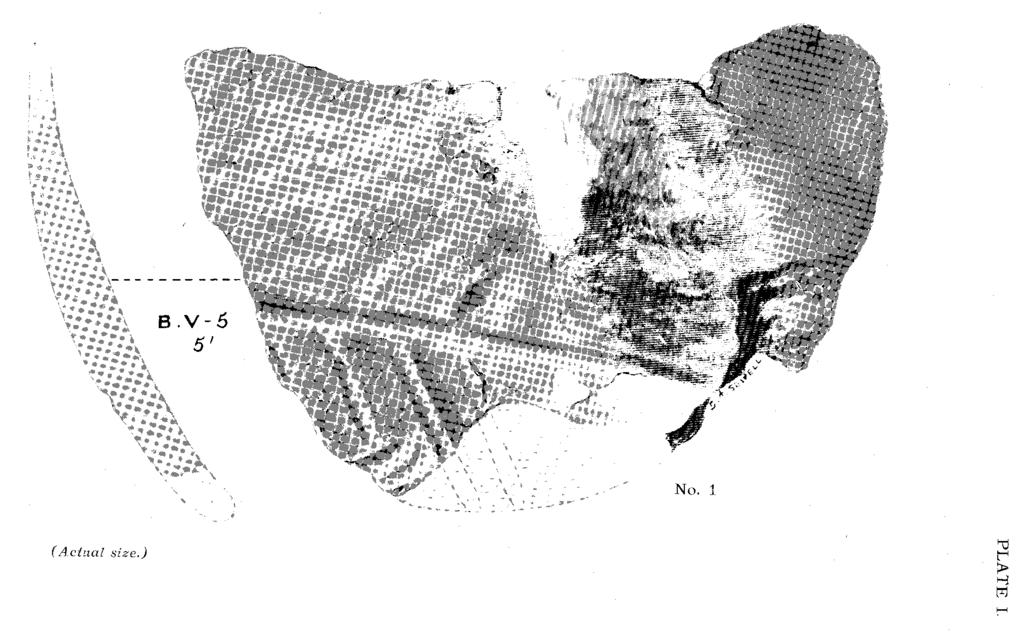
18 No. 1
19 EXCAVATIONS AT DANESBOROUGH CAMP 373 sandstone were found at the deeper levels in all three excavations. Layers and nodules of this material occur naturally in greensand, and would be found in material thrown up from it, In two places in excavations B and C, a number of these stones were found arranged to form very rough hearths, on each of which was a lenticular layer of wood ashes about 9 inches thick at the centre and about 3 feet in diameter. The exact shape and position of these masses of ash is shown in Figs. 2, 3, and 4, and in Fig. 10. At first it was thought that they might mark the sites of small potters' kilns or possibly of a primitive smelting furnace. The complete absence of any wasters of pottery or of scoriae or slag, and the rudeness of the arrangement of the stones, at once negatived any such idea. By far the most important objects found were numerous fragments of pottery. Considering the very limited extent of the excavations, we were fortunate in finding as much as we did, and still more in that most of it could be dated at least approximately, within the comparatively narrow limits of two or three centuries. This pottery will now be described in detail. DESCRIPTION OF THE POTTERY (Plates I-IX) All the pottery found was wheel made, except possibly No. 1, which was doubtful. None of it appeared to be modern or mediaeval. Of the 148 pieces found one was a small complete pot (Plate Y), 16 were portions of rims, and 8 of bases. No handles or spouts of vessels were found. Very few of the fragments could be fitted together, and it was not found possible to reconstruct from the fragments any portion of a pot from rim to base. Portions of at least 15 different kinds of vessel were recognised. With two exceptions no fragment of pottery of any kind was found either on the surface of the ground or at any depth less than 3ft. from it.
20 374 RECORDS OF BUCKINGHAMSHIRE As regards the classification of the pottery, it fell mainly into three broad divisions: - (a) A hard brown or blackish ware, mostly found at the deepest parts of the ditch (none less than 5ft. from the surface, most of it 6-8ft.), and therefore presumably the oldest in date (Plates II, III, IY, YI, 10, 11, 13). (b) A somewhat coarser ware, red or brown on the surface, and with jgrey (ill fired) interior. From the position in which most of it was found (5-9ft. deep) it was apparently of much the same early date as the preceding; (Plate VIII, 19, 21, 22). (c) A hard, very well made, creamy white, ware of good texture, mostly ornamented with horizontal impressed lines (Plate YII). Some of this had a brown burnished surface. It was evidently somewhat later in date than the remainder, and most of it was found at a somewhat higher level (about 3-4 feet deep). Of the total number of fragments, 129 came from excavation B. These could be put into one or other of the above divisions as follows: (a) 30, (b) 44, (c) 55. The fragments from excavation A were mostly of (a) or (b) class, only one fragment of (c) having been found here. The pieces selected for illustration and detailed description (mostly from excavation B) are those which from their shape, texture, or ornamentation are characteristic of the various kinds of pottery that were found. There was nothing in the remainder that is not illustrated by one or other of the specimens figured. The drawings have been made by Mr. Sydney A. Sewell with great care and accuracy. They are of the exact size of the original specimens, with the exception of those in Plate YIII, which have been reduced by one-tenth. The half-tone blocks prepared from them are by Messrs. Waterlow & Sons, Ltd.
21 PLATE II.
")
22 (Actual size.)
23 No. 5 No. 6 (Actual size.)
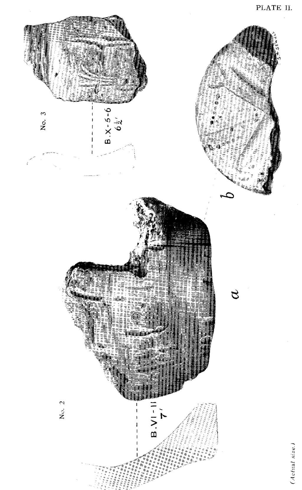
24 EXCAVATION Plate I EXCAVATIONS AT DANESBOROUGH CAMP 375 B No. 1 coarse, reddish, brown ware, ornamented with horizontal and oblique lines, drawn with a stick or other blunt object. Diameter about 15 inches. Centre of ditch. Depth from surface, 5ft. Mr. Reginald Smith considers this to be of " La Tene (pre-roman) date." Plate II No. 2 (a and b). Part of base and side of a thick pot of coarse dark ware rudely ornamented with horizontal and vertical impressed lines. Base flat, with cruciform pattjern and rows of ssmail pits (b). Diameter at base 3ins., at shoulder 4ins. Found near centre of ditch. Depth 7ft. Early Iron Age. No. 3 Fragment of rim of similar ware, perhaps upper part of preceding, close to which it was found. Diameter of mouth about 3ins. Depth 6ft. Early Iron Age. Plate III No. 4 Part of a beaker of Romano-British ware. Smooth dark leather-brown ware. Row of little pits and short lines above the rounded shoulder. Diameter at neck about 2ins., at shoulder about 4ins. Side of ditch. Depth 7ft. Early Iron Age, perhaps list Cent. A.D. Plate IY No. 5 Fragment of ware with smooth leatherbrown surface. Ornament, deeply incised groove of triangular section. Found with two other similar fragments at side of ditch. Depth 7ft. Early Iron Age.,
25 376 RECORDS OF BUCKINGHAMSHIRE No. 6 Fragment of neck of a large pot. Coarse, dark, imperfectly fired ware. Coated with a thin layer of reddish brown clay slip. Centre of ditch. Depth 6ft. Early Iron Age. Plate Y No. 7 Small complete 7 pot of brick red, rather sandy, rough ware. Base flat, and so rough that when the pot is placed on a flat surface it is tilted markedly from the vertical. No ornament. Height ins. Diameter at lipj l ins.., neck (internally) ins., shoulder If ins., base If ins. Centre of ditch. Depth 5ft.? Early Iron Age, but unusual.? Roman. No.- 8 Part of base of a similar pot, also with rough bottom. The section shows the thickness of the base and the pointed lower end of the interior of this and the preceding. Centre of ditch. Depth 6ft. No. 9 Part of neck and rim of an apparently somewhat similar but smaller pot. Centre of ditch. Depth 6ft. With regard to these three pots (7, 8, and 9) it is very difficult to assign a definite date to them. They are certainly rare, and there is, apparently, nothing quite like them in the British Museum or the Cambridge Archaeological Museum. The shape of the neck and rim seem to suggest Early Iron age, but on the other hand the exceeding irregularity of the base in 7 and 8 is certainly very unusual, and demands some explanation. Mr., Reginald Smith, who was at first inclined to assign all three to the Early Iron Age, has recently kindly drawn my attention to an illustrated paper by Mr. Walter J. Kaye, jun., F.S.A., on 7 Quite complete when first excavated except for a slight cut on the side caused by the spade. Afterwards a portion of the rim was unfortunately broken off and lost.
26 No. 8

27 PLATE VI. No. 15 (Actual size.)
28 EXCAVATIONS AT DANESBOROUGH CAMP 377 " Roman and other Triple Vases " and writes to me (Jan. 1, 1926): " I feel almost certain, after looking at the paper once more, that your three examples belonged together, and were stuck on a ring of clay. Roman period." This affords a good explanation of the roughness of the bases of 7 and 8, which certainly look as if they had been loosely attached to something else and subsequently detached without any actual fracture. The great majority of the vessels figured by Mr. Kaye seem, however, to be much more definitely Roman as regards the neck and rim than do those of Danesborough. Plate VI No. 10 Part of a rim of pot or bowl, with slightly concave neck. Leather-brown smooth ware. Diameter of lip 5 ins., neck (internally) 5ins. Centre of ditch. Depth 5 ft. Early Iron Age. No. 11 Part of rim of similar ware, but with slightly different mouldings of the edge. Diameter about 7ins. Centre of ditch. Depth 5ft. Early Iron Age, a little later than the preceding. The neck an this and the preceding specimen presents, immediately below the projecting rim, a slightly concave horizontal band f-f-inch deep. In the development of this class of pottery this band tends to pass gradually from the concave to the absolutely fiat, vertical surface. Specimen No. 10, with its definite CON- cavity, Mr. Smith attributes to the first quarter of the 1st Cent. A.I)., that is, just pre-roman. 8 The Antiquary, Vol. 50, 1914, pp. 172, 223, and 290.
29 378 RECORDS OF BUCKINGHAMSHIRE No. 11, in which the surface is almost flat, is of slightly later date, while in others, still later (not represented in our collection) the band is absolutely flat and vertical. The slightly more elaborate moulding of the projecting rim of 11, compared with 10, points in the same direction, to slight further development, and therefore later date. No. 12 Part of rim of a large bowl or basin of coarse brown gritty ware. No ornament. Diameter about 1ft. or more. Centre of ditch. Depth 5ft. Probably early Romano-British period. No. 13 Fragment of a rim similar to No, 3, as regards colour, texture, and size, but without ornament. Depth 6ft, Early Iron Age. No. 14 Fragment of rim of vessel of pale brownish, hard and rather gritty ware. Diameter about51/2ins. Depth 31/2 ft. Early Romano-British period. No. 15 A similar fragment of rim,, with slightly different moulding. Depth 3ft, Early Romano-British period. Plate VII Nos. 16, 17, and 18. Three fragments (out of more than 50 found) of a hard, well fired, thin, pale buff or cream coloured ware, of much better texture than any of the preceding (except 14 and 15). The paste of some of the pieces is almost white. The ornament consists of very sharply defined parallel grooves of triangular section. Many of the fragments show a brown burnish on the outer surface. The curvature of the fragments in most cases shows that the diameter of the pot from which they came was about 6ins.
30 No. 16
31 EXCAVATIONS AT DANESBOROUGH CAMP 379 No bases or rims definitely belonging to this class of ware were found. With the exception of one piece (17) found at 2ft. near the side of the ditch, and of 4 pieces found at a somewhat lower level than all the rest, the whole of this pottery was found at a depth of 3-4ft, that is well above the levels at. which most of the other pottery was found. Mr. Reginald Smith tells me that he cannot match it in the British Museum, but that it " may be Roman or of Roman period with traces of British technique. It is certainly later than the bulk of the pottery found." Dr. Cyril Fox cannot match it at the Cambridge Archaeological Museum, but agrees as to this being its probable date. Mr. F. W. Reader, formerly one of the late General Pitt Rivers's assistants, considers it to be " Late Keltic," and similar to some found by that archaeologist in Wiltshire. A search through the pottery in the Farnham Museum has failed to produce anything quite like it. nor can I find the same ware figured in any of Pitt Rivers's plates. I have not been able to find any pottery quite like this in any of the English museums that I have examined, but I have seen in the Namur Museum some pottery of exactly the same colour and texture, but without the incised lines of ornament. This came from a Belgian site, and was attributed to the second century A.D. 9 9 It is interesting to note that the discovery of a piece of ornamented red Samian ware by Dr. Bradbrooke at Roman Magiovinium, only two miles from our camp, was published by Prof. Haverfield; it was attributed by him and other experts, to the end of I. Cent. A.D. or the beginning of II. A.D., and to be of EGaulish origin. See Proc. Soc. Antiq. 2nd Series XXIV 35. Jan
32 380 RECORDS OF BUCKINGHAMSHIRE Plate VIII No. 19 Base of a shallow dish or bowl with a raised circular foot -inch high with diameter 2ins. Soft poor ware with 'soapy' surface, and dark interior and reddish brown exterior. Near centre of ditch. Depth 6ft. Mr. H, A. Smith and Dr. Cyril Fox attribute this to 1st Cent. B.C. No. 20 Fragment of base of hard dark brown ware. Base flat, with a deeply incised narrow groove close to outer edge. Diameter of base 2ins. From the side of the ditch. Depth 7ft. This base with its incised ring is exactly matched by Pot 24, 793, in the Cambridge Museum, said to have come from the neighbourhood of Cambridge. Probably 1st Cent., A.D. No. 21 Part of side and flat base of a large bowl of coarse reddish brown ware with dark (ill-fired) interior. Diameter of base about 6ins. Depth 5ft. Early Iron Age. No. 22 Part of base and side of somewhat similar shallow bowl of same ware, but coated with clay slip. Ornament, vertical lines impressed on clay slip. Base raised about J-inch by moulding at the edge. Diameter of base about 4ins. Near centre of ditch. Depth 7ft. Early Iron Age (Dr. Fox); probably La Tene III. (Mr. Smith). No. 23 Fragment of similar rough red ware, with flat base and no ornament. Near centre of ditch. Depth 3ft. Dr. Fox and Mr. Smith both attribute this fragment to 1st half of 1st Cent., A.D.
33 (Reduced 9/l0ths.)

34 No. 22 No. 23 (Reduced 9/10ths.)
35 (Actual size)
36 EXCAVATION EXCAVATIONS AT DANESBOROUGH CAMP 381 A Plate IX No. 24 Fragment of a rim of a large dish or jar, of coarse red earthenware, with ' soapy' surface. Diameter about 12ins. Thickness -inch. Found in the silting of the ditch 40 feet from the centre of the causeway near its junction with the ditch, but on the vallum side of it. Depth 4ft. Probably Early 1st Cent., A.D. No. 25 Fragment of rim of a somewhat similar jar of coarser reddish brown earthenware. Diameter about 15ins. Thickness 3/4-inch. Found in the silting of the ditch 43 feet from the centre of the causeway on the vallum side of the ditch. Depth 6ft. Probably Early 1st Cent., A.D. EXCAVATION C This yielded no pottery. CONCLUSIONS It is the duty of a local archaeological society to record facts, with as much detail as possible, and not to wander off too much into the realm; of theory, in which it is easy to go astray. Facts duly and carefully recorded may be of -considerable value to experts whose wider knowledge may enable them to draw conclusions and to generalise in a manner which it is not always wise for amateurs to attempt. The classification and dating of Early Iron Age pottery is admittedly very difficult. Speaking generally, more is known at present about the identification of Bronze Age pottery than of Early Iron Age pottery. It is often hard to say definitely whether a particular piece of pottery should be attributed to the Early Iron Age or to the subsequent Romano-British period. No doubt there was much

37 382 RECORDS OF BUCKINGHAMSHIRE overlapping of the two periods. In different parts of the country, or even in the same part, both kinds of pottery were being simultaneously manufactured side by side for a considerable time, until the superior culture of the invaders gradually replaced that of the natives./ It must not be assumed that upon the advent of the Romans to our country, the British potters immediately dropped their tools and methods and adopted those of their conquerors. The process of conversion must often have been a gradual one. Although negative evidence is not of any great value in the case of excavations of such limited extent, yet no Bronze Age pottery was forthcoming, nor any that could reasonably be dated later than about the second century A.D. No glazed pottery, or coins, or any objects of metal or glass were found. The pottery that was found made it clear that the ditch was in existence at least many centuries before the period of the Danish invasions. It could not have been made by these people. Whether they, at any time, occupied the already existing enclosure is another matter, upon which the excavations afford no evidence either for or against. Similarly, the few flint flakes found, of which only two show definite evidence of human workmanship, afford no help in the dating of the camp. The Neolithic people, who presumably worked these flints, may have wandered about upon, or even occupied, the site long before the camp was made, and dropped these flints upon the ground. Tlhe finding of so many fragments of pottery of Earlv Iron or Romano-British Age, so near the bottom of the ditch, and the complete absence of any pottery of still earlier date, make it unlikely that the ditch was made, at most, more than a very few centuries before the advent of the Romans to this country. On the other hand, it must be remembered that only an extremely small portion of the actual bottom of the ditch has been uncovered. Subsequent exploration will doubtless throw fresh light upon the subject, and may serve to confirm or modify the conclusions at which we have arrived.
38 Two flints of human workmanship, found in Excavation A. (See page 371). PLATE X.
39 EXCAVATIONS AT DANESBOROUGH CAMP 383 The presence of the two piles of ashes in excavation B and C tell us but little. Situated in each case 3-4ft. below the present surface of the ground and approximately on the same level as the later fragments of pottery, they have no necessary connection with the inhabitants of the camp. They may well have come from fires lighted by some casual wanderers who may have sought a temporary shelter in the ditch perhaps after the camp had been abandoned by its original makers and inhabitants. Within the necessary narrow limits of the present exploration it is clear that the work was abundantly justified by the effectual answers it gave to the two main questions raised on page 363. Meanwhile the results encourage one to hope that it may be found possible, at some future time, to make a further examination on similar lines, with a view to answering some of the.many other questions which arise in connection with this important and interesting earthwork.
Chapter 2. Remains. Fig.17 Map of Krang Kor site
 Chapter 2. Remains Section 1. Overview of the Survey Area The survey began in January 2010 by exploring the site of the burial rootings based on information of the rooted burials that was brought to the
A NEW ROMAN SITE IN CHESHAM
 A NEW ROMAN SITE IN CHESHAM KEITH BRANIGAN AND MICHAEL KIRTON THE site under discussion was first noted in 1958 and since that time several discoveries have been made. Its investigation has been pursued
A visit to the Wor Barrow 21 st November 2015
 A visit to the Wor Barrow 21 st November 2015 Following our exploration of Winkelbury a few weeks previously, we fast forwarded 12 years in Pitt Rivers remarkable series of excavations and followed him
DEMARCATION OF THE STONE AGES.
 20 HAMPSHIRE FLINTS. DEMARCATION OF THE STONE AGES. BY W, DALE, F.S.A., F.G.S. (Read before the Anthropological Section of -the British Association for the advancement of Science, at Birmingham, September
1. Presumed Location of French Soundings Looking NW from the banks of the river.
 SG02? SGS SG01? SG4 1. Presumed Location of French Soundings Looking NW from the banks of the river. The presumed location of SG02 corresponds to a hump known locally as the Sheikh's tomb. Note also (1)
ARCHAEOLOGICAL EVALUATION AT BRIGHTON POLYTECHNIC, NORTH FIELD SITE, VARLEY HALLS, COLDEAN LANE, BRIGHTON. by Ian Greig MA AIFA.
 ARCHAEOLOGICAL EVALUATION AT BRIGHTON POLYTECHNIC, NORTH FIELD SITE, VARLEY HALLS, COLDEAN LANE, BRIGHTON by Ian Greig MA AIFA May 1992 South Eastern Archaeological Services Field Archaeology Unit White
HANT3 FIELD CLUB AND ARCH^OLOGICAL SOCIETY, PLATE 4
 HANT3 FIELD CLUB AND ARCH^OLOGICAL SOCIETY, 1898. PLATE 4 VUU*. ilurti.14 HALF SIZE. BRONZE PALSTAVES, FOUND AT PEAR TREE GREEN. n BRONZE IMPLEMENTS FROM THE. NEIGHBOURHOOD OF SOUTHAMPTON, BY W. DALE,
THE RAVENSTONE BEAKER
 DISCOVERY THE RAVENSTONE BEAKER K. J. FIELD The discovery of the Ravenstone Beaker (Plate Xa Fig. 1) was made by members of the Wolverton and District Archaeological Society engaged on a routine field
Cetamura Results
 Cetamura 2000 2006 Results A major project during the years 2000-2006 was the excavation to bedrock of two large and deep units located on an escarpment between Zone I and Zone II (fig. 1 and fig. 2);
Test-Pit 3: 31 Park Street (SK )
") -Pit 3: 31 Park Street (SK 40732 03178) -Pit 3 was excavated in a flower bed in the rear garden of 31 Park Street, on the northern side of the street and west of an alleyway leading to St Peter s Church,
-Pit 3: 31 Park Street (SK 40732 03178) -Pit 3 was excavated in a flower bed in the rear garden of 31 Park Street, on the northern side of the street and west of an alleyway leading to St Peter s Church,
SALVAGE EXCAVATIONS AT OLD DOWN FARM, EAST MEON
 Proc. Hants. Field Club Archaeol. Soc. 36, 1980, 153-160. 153 SALVAGE EXCAVATIONS AT OLD DOWN FARM, EAST MEON By RICHARD WHINNEY AND GEORGE WALKER INTRODUCTION The site was discovered by chance in December
A COIN OF OFFA FOUND IN A VIKING-AGE BURIAL AT VOSS, NORWAY. Bergen Museum.
 A COIN OF OFFA FOUND IN A VIKING-AGE BURIAL AT VOSS, NORWAY. BY HAAKON SCHETELIG, Doct. Phil., Curator of the Bergen Museum. Communicated by G. A. AUDEN, M.A., M.D., F.S.A. URING my excavations at Voss
Colchester Archaeological Trust Ltd. A Fieldwalking Survey at Birch, Colchester for ARC Southern Ltd
 Colchester Archaeological Trust Ltd A Fieldwalking Survey at Birch, Colchester for ARC Southern Ltd November 1997 CONTENTS page Summary... 1 Background... 1 Methods... 1 Retrieval Policy... 2 Conditions...
Archaeological sites and find spots in the parish of Burghclere - SMR no. OS Grid Ref. Site Name Classification Period
 Archaeological sites and find spots in the parish of Burghclere - SMR no. OS Grid Ref. Site Name Classification Period SU45NE 1A SU46880 59200 Ridgemoor Farm Inhumation Burial At Ridgemoor Farm, on the
St Germains, Tranent, East Lothian: the excavation of Early Bronze Age remains and Iron Age enclosed and unenclosed settlements
 Proc Soc Antiq Scot, 128 (1998), 203-254 St Germains, Tranent, East Lothian: the excavation of Early Bronze Age remains and Iron Age enclosed and unenclosed settlements Derek Alexander* & Trevor Watkinsf
AN EARLY MEDIEVAL RUBBISH-PIT AT CATHERINGTON, HAMPSHIRE Bj>J. S. PILE and K. J. BARTON
 AN EARLY MEDIEVAL RUBBISH-PIT AT CATHERINGTON, HAMPSHIRE Bj>J. S. PILE and K. J. BARTON INTRODUCTION THE SITE (fig. 21) is situated in the village of Catherington, one mile north-west of Horndean and 200
FOUR BRONZE IMPLEMENTS.
 FOUR BRONZE IMPLEMENTS 349 FOUR BRONZE IMPLEMENTS. BY EDWIN HOLLIS. The four implements illustrated witli this article have, I believe, not previously been described. Together they form a very interesting
Fieldwalking at Cottam 1994 (COT94F)
") Fieldwalking at Cottam 1994 (COT94F) Tony Austin & Elizabeth Jelley (19 Jan 29) 1. Introduction During the winter of 1994 students from the Department of Archaeology at the University of York undertook
Fieldwalking at Cottam 1994 (COT94F) Tony Austin & Elizabeth Jelley (19 Jan 29) 1. Introduction During the winter of 1994 students from the Department of Archaeology at the University of York undertook
Notes on Two Bronze Age Discoveries 1n Leicestershire by
 Notes on Two Bronze Age Discoveries 1n Leicestershire by T. G. E. Powell (1) Bronze Age Cremation Burial from Earl Shilton In the course of sand digging in 1938, an urn containing cremated bones was found
To Gazetteer Introduction
 To Gazetteer Introduction Aylesford Belgic Cemetery - Grog-tempered 'Belgic' Pottery of South-eastern England AYLESFORD (K) TQ 727 594 Zone 4 It was in the publication of this cemetery that Evans (1890)
Any Number of Effigy Mounds, Some of Them Artistic A Modern Indian s Bones- Finds of Pottery, Arrows and Stone Implements
 New York Times Prehistoric Wisconsin Ancient Mounds and Earth Works Lately Discovered Any Number of Effigy Mounds, Some of Them Artistic A Modern Indian s Bones- Finds of Pottery, Arrows and Stone Implements
ON "ROMANO-BRITISH" FICTILE VESSELS ]?ROM PRESTON NEAR WINGHAM.
![ON ROMANO-BRITISH FICTILE VESSELS ]?ROM PRESTON NEAR WINGHAM.](/thumbs/83/87866288.jpg "ON ROMANO-BRITISH FICTILE VESSELS ]?ROM PRESTON NEAR WINGHAM.") Archaeologia Cantiana Vol. 20 1893 ON "ROMANO-BRITISH" FICTILE VESSELS ]?ROM PRESTON NEAR WINGHAM. BT &. DOWKEB. IN 1889 the late Mr. Charles Roach Smith wrote to me, " "What evil genius hinders you from
Archaeologia Cantiana Vol. 20 1893 ON "ROMANO-BRITISH" FICTILE VESSELS ]?ROM PRESTON NEAR WINGHAM. BT &. DOWKEB. IN 1889 the late Mr. Charles Roach Smith wrote to me, " "What evil genius hinders you from
Grim s Ditch, Starveall Farm, Wootton, Woodstock, Oxfordshire
 Grim s Ditch, Starveall Farm, Wootton, Woodstock, Oxfordshire An Archaeological Recording Action For Empire Homes by Steve Ford Thames Valley Archaeological Services Ltd Site Code SFW06/118 November 2006
MARSTON MICHAEL FARLEY
 MARSTON MICHAEL FARLEY On 9 March agricultural contractors, laying field drains for Bucks County Council Land Agent's Department, cut through a limestone structure at SP 75852301 in an area otherwise consistently
 While every reasonable attempt has been made to obtain permission to use the images reproduced in this article, it has not been possible to trace or contact the respective copyright holders. There has
SERIATION: Ordering Archaeological Evidence by Stylistic Differences
 SERIATION: Ordering Archaeological Evidence by Stylistic Differences Seriation During the early stages of archaeological research in a given region, archaeologists often encounter objects or assemblages
An archaeological evaluation at the Lexden Wood Golf Club (Westhouse Farm), Lexden, Colchester, Essex
, Lexden, Colchester, Essex") An archaeological evaluation at the Lexden Wood Golf Club (Westhouse Farm), Lexden, Colchester, Essex January 2000 Archive report on behalf of Lexden Wood Golf Club Colchester Archaeological Trust 12 Lexden
An archaeological evaluation at the Lexden Wood Golf Club (Westhouse Farm), Lexden, Colchester, Essex January 2000 Archive report on behalf of Lexden Wood Golf Club Colchester Archaeological Trust 12 Lexden
Excavations at Shikarpur, Gujarat
 Excavations at Shikarpur, Gujarat 2008-2009 The Department of Archaeology and Ancient History, the M. S. University of Baroda continued excavations at Shikarpur in the second field season in 2008-09. In
IRAN. Bowl Northern Iran, Ismailabad Chalcolithic, mid-5th millennium B.C. Pottery (65.1) Published: Handbook, no. 10
 Published: Handbook, no. 10") Bowl Northern Iran, Ismailabad Chalcolithic, mid-5th millennium B.C. Pottery (65.1) IRAN Published: Handbook, no. 10 Bowl Iran, Tepe Giyan 2500-2000 B.C. Pottery (70.39) Pottery, which appeared in Iran
Bowl Northern Iran, Ismailabad Chalcolithic, mid-5th millennium B.C. Pottery (65.1) IRAN Published: Handbook, no. 10 Bowl Iran, Tepe Giyan 2500-2000 B.C. Pottery (70.39) Pottery, which appeared in Iran
Church of St Peter and St Paul, Great Missenden, Buckinghamshire
 Church of St Peter and St Paul, Great Missenden, Buckinghamshire An Archaeological Watching Brief for the Parish of Great Missenden by Andrew Taylor Thames Valley Archaeological Services Ltd Site Code
7. Prehistoric features and an early medieval enclosure at Coonagh West, Co. Limerick Kate Taylor
 7. Prehistoric features and an early medieval enclosure at Coonagh West, Co. Limerick Kate Taylor Illus. 1 Location of the site in Coonagh West, Co. Limerick (based on the Ordnance Survey Ireland map)
Tell Shiyukh Tahtani (North Syria)
") Tell Shiyukh Tahtani (North Syria) Report of the 2010 excavation season conducted by the University of Palermo Euphrates Expedition by Gioacchino Falsone and Paola Sconzo In the summer 2010 the University
Tell Shiyukh Tahtani (North Syria) Report of the 2010 excavation season conducted by the University of Palermo Euphrates Expedition by Gioacchino Falsone and Paola Sconzo In the summer 2010 the University
A Sense of Place Tor Enclosures
 A Sense of Place Tor Enclosures Tor enclosures were built around six thousand years ago (4000 BC) in the early part of the Neolithic period. They are large enclosures defined by stony banks sited on hilltops
The Iron Handle and Bronze Bands from Read's Cavern: A Re-interpretation
 46 THE IRON HANDLE AND BRONZE BANDS FROM READ'S CAVERN The Iron Handle and Bronze Bands from Read's Cavern: A Re-interpretation By JOHN X. W. P. CORCORAN. M.A. Since the publication of the writer's study
New Composting Centre, Ashgrove Farm, Ardley, Oxfordshire
 New Composting Centre, Ashgrove Farm, Ardley, Oxfordshire An Archaeological Watching Brief For Agrivert Limited by Andrew Weale Thames Valley Archaeological Services Ltd Site Code AFA 09/20 August 2009
Cambridge Archaeology Field Group. Fieldwalking on the Childerley Estate, Cambridgeshire. Autumn 2014 to Spring Third interim report
 Cambridge Archaeology Field Group Fieldwalking on the Childerley Estate, Cambridgeshire Autumn 2014 to Spring 2015 Third interim report Summary Field walking on the Childerley estate of Martin Jenkins
Control ID: Years of experience: Tools used to excavate the grave: Did the participant sieve the fill: Weather conditions: Time taken: Observations:
 Control ID: Control 001 Years of experience: No archaeological experience Tools used to excavate the grave: Trowel, hand shovel and shovel Did the participant sieve the fill: Yes Weather conditions: Flurries
Cambridge Archaeology Field Group. Fieldwalking on the Childerley Estate Cambridgeshire
 Cambridge Archaeology Field Group Fieldwalking on the Childerley Estate Cambridgeshire 2009 to 2014 Summary Fieldwalking on the Childerley estate of Martin Jenkins and Family has revealed, up to March
3. The new face of Bronze Age pottery Jacinta Kiely and Bruce Sutton
 3. The new face of Bronze Age pottery Jacinta Kiely and Bruce Sutton Illus. 1 Location map of Early Bronze Age site at Mitchelstown, Co. Cork (based on the Ordnance Survey Ireland map) A previously unknown
An archaeological evaluation at 16 Seaview Road, Brightlingsea, Essex February 2004
 An archaeological evaluation at 16 Seaview Road, Brightlingsea, Essex February 2004 report prepared by Kate Orr on behalf of Highfield Homes NGR: TM 086 174 (c) CAT project ref.: 04/2b ECC HAMP group site
T so far, by any other ruins in southwestern New Mexico. However, as
 TWO MIMBRES RIVER RUINS By EDITHA L. WATSON HE ruins along the Mimbres river offer material for study unequaled, T so far, by any other ruins in southwestern New Mexico. However, as these sites are being
Erection of wind turbine, Mains of Loanhead, Old Rayne, AB52 6SX
 Erection of wind turbine, Mains of Loanhead, Old Rayne, AB52 6SX Ltd 23 November 2011 Erection of wind turbine, Mains of Loanhead, Old Rayne, AB52 6SX CONTENTS 1 INTRODUCTION 3 2 ARCHAEOLOGICAL BACKGROUND
SAXON AND MEDIEVAL POTTERY FRO~i!(IRBY BELLARS
 SAXON AND MEDEVAL POTTERY FROi!(RBY BELLARS by J. G. HURST n 1960 excavations in the churchyard at Kirby Bellars 1 produced over 500 sherds of pottery dating from the Roman period to the present day. 2
A HOARD OF EARLY IRON AGE GOLD TORCS FROM IPSWICH
 A HOARD OF EARLY IRON AGE GOLD TORCS FROM IPSWICH ByJ. W. BRAILSFORD, M.A., F.S.A. On 26 October 1968 five gold torcs (Plates XX, XXI, XXII) of the Early Iron Age were found at Belstead Hills Estate, Ipswich
An archaeological evaluation in the playground of Colchester Royal Grammar School, Lexden Road, Colchester, Essex
 An archaeological evaluation in the playground of Colchester Royal Grammar School, Lexden Road, Colchester, Essex February 2002 on behalf of Roff Marsh Partnership CAT project code: 02/2c Colchester Museum
198 S. ALBANS AND HERTS ARCHITECTURAL AND ARCHAEOLOGICAL SOCIETY. REPORT FOR BY WILLIAM PAGE, F.S.A.
 198 S. ALBANS AND HERTS ARCHITECTURAL AND ARCHAEOLOGICAL SOCIETY. REPORT FOR 1898-9. BY WILLIAM PAGE, F.S.A. It is difficult for those who have made no study of the Roman occupation of this country to
39, Walnut Tree Lane, Sudbury (SUY 073) Planning Application No. B/04/02019/FUL Archaeological Monitoring Report No. 2005/112 OASIS ID no.
 Planning Application No. B/04/02019/FUL Archaeological Monitoring Report No. 2005/112 OASIS ID no.") 39, Walnut Tree Lane, Sudbury (SUY 073) Planning Application No. B/04/02019/FUL Archaeological Monitoring Report No. 2005/112 OASIS ID no. 9273 Summary Sudbury, 39, Walnut Tree Lane, Sudbury (TL/869412;
39, Walnut Tree Lane, Sudbury (SUY 073) Planning Application No. B/04/02019/FUL Archaeological Monitoring Report No. 2005/112 OASIS ID no. 9273 Summary Sudbury, 39, Walnut Tree Lane, Sudbury (TL/869412;
An archaeological watching brief and recording at Brightlingsea Quarry, Moverons Lane, Brightlingsea, Essex October 2003
 An archaeological watching brief and recording at Brightlingsea Quarry, Moverons Lane, Brightlingsea, Essex commissioned by Mineral Services Ltd on behalf of Alresford Sand & Ballast Co Ltd report prepared
Greater London GREATER LONDON 3/606 (E ) TQ
 TQ") GREATER LONDON City of London 3/606 (E.01.6024) TQ 30358150 1 PLOUGH PLACE, CITY OF LONDON An Archaeological Watching Brief at 1 Plough Place, City of London, London EC4 Butler, J London : Pre-Construct
GREATER LONDON City of London 3/606 (E.01.6024) TQ 30358150 1 PLOUGH PLACE, CITY OF LONDON An Archaeological Watching Brief at 1 Plough Place, City of London, London EC4 Butler, J London : Pre-Construct
THE nineteen sites described below all lie on Port Meadow, a large flat
 Archaeological Sites on Port Meadow, Oxford By R. J. C. ATKINSON THE nineteen sites described below all lie on Port Meadow, a large flat grazing-ground of some 300 acres, which lies immediately to the
REPORT ON THE TRIAL EXCAVATIONS AT WARDS COOMBE, IVINGHOE
 REPORT ON THE TRIAL EXCAVATIONS AT WARDS COOMBE, IVINGHOE. 1971. B. R. K. DUNNETT. B.A. During 1970 woodland clearance on National Trust property at Wards Coombe, near Ivinghoe Beacon (Grid Reference S.P.
Azerbaijan National Academy of Sciences Institute of Archaeology and Ethnography. Safar Ashurov
 Azerbaijan National Academy of Sciences Institute of Archaeology and Ethnography Safar Ashurov Zayamchay Report On Excavations of a Catacomb Burial At Kilometre Point 355 of Baku-Tbilisi-Ceyhan and South
I MADE THE PROBLEM UP,
 This assignment will be due Thursday, Oct. 12 at 10:45 AM. It will be late and subject to the late penalties described in the syllabus after Friday, Oct. 13, at 10:45 AM. Complete submission of this assignment
Fieldwalk On Falmer Hill, Near Brighton - Second Season
 Fieldwalk On Falmer Hill, Near Brighton - Second Season by the Brighton and Hove Archaeological Society This report as well as describing the recent fieldwalks also includes descriptions of previous discoveries
Part 10: Chapter 17 Pleated Buttoning
 Part 10: Chapter 17 Pleated Buttoning OUR last chapter covered the upholstering of one of the commonest forms of chair frames. The same chair may be upholstered with deeper buttoning, but instead of indenting
Moray Archaeology For All Project
 School children learning how to identify finds. (Above) A flint tool found at Clarkly Hill. Copyright: Leanne Demay Moray Archaeology For All Project ational Museums Scotland have been excavating in Moray
STONE implements and pottery indicative of Late Neolithic settlement are known to
 Late Neolithic Site in the Extreme Northwest of the New Territories, Hong Kong Received 29 July 1966 T. N. CHIU* AND M. K. WOO** THE SITE STONE implements and pottery indicative of Late Neolithic settlement
Monitoring Report No. 99
 Monitoring Report No. 99 Enniskillen Castle Co. Fermanagh AE/06/23 Cormac McSparron Site Specific Information Site Name: Townland: Enniskillen Castle Enniskillen SMR No: FER 211:039 Grid Ref: County: Excavation
NOTE A THIRD CENTURY ROMAN BURIAL FROM MANOR FARM, HURSTBOURNE PRIORS. by. David Allen with contributions by Sue Anderson and Brenda Dickinson
 Proc. Hampsh. Field Club Archaeol. Soc. 47, 1991, 253-257 NOTE A THIRD CENTURY ROMAN BURIAL FROM MANOR FARM, HURSTBOURNE PRIORS Abstract by. David Allen with contributions by Sue Anderson and Brenda Dickinson
Section Worked stone catalogue By Hugo Anderson-Whymark
 Section 4.11.2 Worked stone catalogue By Hugo Anderson-Whymark Table 4.67: Worked stone from Alfred s Castle. TR Ctxt SF No 1 1000 0 Weaponry Sling-shot Flint pebble 100 1 57 43 37 27 Iron Age 1 1160 0
An early pot made by the Adena Culture (800 B.C. - A.D. 100)
") Archaeologists identify the time period of man living in North America from about 1000 B.C. until about 700 A.D. as the Woodland Period. It is during this time that a new culture appeared and made important
Archaeologists identify the time period of man living in North America from about 1000 B.C. until about 700 A.D. as the Woodland Period. It is during this time that a new culture appeared and made important
Available through a partnership with
 The African e-journals Project has digitized full text of articles of eleven social science and humanities journals. This item is from the digital archive maintained by Michigan State University Library.
Old iron-producing furnaces in the eastern hinterland of Bagan, Myanmar.
 Old iron-producing furnaces in the eastern hinterland of Bagan, Myanmar. Field survey and initial excavation. Bob Hudson U Nyein Lwin. 2002. In November 2001, an investigation was made of a number of sites
The lab Do not wash metal gently Never, ever, mix finds from different layers
 8 The lab 8.1 Finds processing The finds from the excavations at all parts of the site are brought down at the end of the day to the lab in the dig house. Emma Blake oversees the processing. Monte Polizzo
Silwood Farm, Silwood Park, Cheapside Road, Ascot, Berkshire
 Silwood Farm, Silwood Park, Cheapside Road, Ascot, Berkshire An Archaeological Watching Brief For Imperial College London by Tim Dawson Thames Valley Archaeological Services Ltd Site Code SFA 09/10 April
REPORT FROM THE ANTIGUA ARCHAEOLOGICAL SOCIETY ARAWAK CAMPSITES ON ANTIGUA. by M. Fred OLSEN Secretary, Antigua Archaeological Society
 REPORT FROM THE ANTIGUA ARCHAEOLOGICAL SOCIETY ARAWAK CAMPSITES ON ANTIGUA by M. Fred OLSEN Secretary, Antigua Archaeological Society Our first excavation of Arawak sites in Antigua was started in December
Evidence for the use of bronze mining tools in the Bronze Age copper mines on the Great Orme, Llandudno
 Evidence for the use of bronze mining tools in the Bronze Age copper mines on the Great Orme, Llandudno Background The possible use of bronze mining tools has been widely debated since the discovery of
Archaeological Material From Spa Ghyll Farm, Aldfield
 Archaeological Material From Spa Ghyll Farm, Aldfield Introduction Following discussions with Linda Smith the Rural Archaeologist for North Yorkshire County Council, Robert Morgan of 3D Archaeological
The Jawan Chamber Tomb Adapted from a report by F.S. Vidal, Dammam, December 1953
 Figure 1 - The Jawan tomb as photographed from helicopter by Sgt. W. Seto, USAF, in May 1952 The Jawan Chamber Tomb Adapted from a report by F.S. Vidal, Dammam, December 1953 I. Description of work and
Chapel House Wood Landscape Project. Interim Report 2013
 Chapel House Wood Landscape Project Interim Report 2013 Chapel House Wood Landscape Project Interim Report 2013 The annual Dales Heritage Field School was held at Chapel House Wood again this year, and
Peace Hall, Sydney Town Hall Results of Archaeological Program (Interim Report)
") Results of Archaeological Program (Interim Report) Background The proposed excavation of a services basement in the western half of the Peace Hall led to the archaeological investigation of the space in
Results of Archaeological Program (Interim Report) Background The proposed excavation of a services basement in the western half of the Peace Hall led to the archaeological investigation of the space in
The Romano-British Cemetery at The Grange, Welwyn, Herts,
 The Romano-British Cemetery at The Grange, Welwyn, Herts, BY W. PERCIVAL WESTELL, F.L.S., F.S.A. Scot., M.R.A.I. Curator of Letchworth Museum. FOR many years past it has been recognised by archaeologists
Undley Hall, Lakenheath LKH 307
 ARCHAEOLOGICAL EVALUATION AND MONITORING REPORT SCCAS REPORT No. 2010/005 Undley Hall, Lakenheath LKH 307 E. Muldowney SCCAS January 2010 www.suffolkcc.gov.uk/e-and-t/archaeology Lucy Robinson, County
Artifacts. Antler Tools
 Artifacts Artifacts are the things that people made and used. They give a view into the past and a glimpse of the ingenuity of the people who lived at a site. Artifacts from the Tchefuncte site give special
A BARROW ON WOOTTON COMMON, HANTS.
 116 HAMPSHIRE FIELD CLUB A BARROW ON WOOTTON COMMON, HANTS. By W. A. SEABY, F.S.A. T Discovery of the Barrow. HE burning of the gorse bushes on the eastern half of Wootton Common, early in 1939, exposed
Human remains from Estark, Iran, 2017
 Bioarchaeology of the Near East, 11:84 89 (2017) Short fieldwork report Human remains from Estark, Iran, 2017 Arkadiusz Sołtysiak *1, Javad Hosseinzadeh 2, Mohsen Javeri 2, Agata Bebel 1 1 Department of
MacDonald of Glenaladale
 Background MacDonald of Glenaladale The MacDonald of Glenaladale is one of a small group of tartans where an extant specimen survives that can accurately be dated to the mid-c18th. For many years confusion
Hembury Hillfort Lesson Resources. For Key Stage Two
 Hembury Hillfort Lesson Resources For Key Stage Two 1 Resource 1 Email 1 ARCHAEOLOGISTS NEEDED Dear Class, I recently moved to Payhembury and I have been having fun exploring the beautiful Blackdown Hills.
Fort Arbeia and the Roman Empire in Britain 2012 FIELD REPORT
 Fort Arbeia and the Roman Empire in Britain 2012 FIELD REPORT Background Information Lead PI: Paul Bidwell Report completed by: Paul Bidwell Period Covered by this report: 17 June to 25 August 2012 Date
Grange Farm, Widmer End, Hughenden, Buckinghamshire
 Grange Farm, Widmer End, Hughenden, Buckinghamshire An Archaeological Evaluation for British Flora by Andy Taylor Thames Valley Archaeological Services Ltd Site Code GFH 05/63 July 2005 Summary Site name:
ROYAL MAYAN TOMB. Faculty Sponsor: Kathryn Reese-Taylor, Department of Sociology/Archaeology
 ROYAL MAYAN TOMB 93 Royal Mayan Tomb Jennifer Vander Galien Faculty Sponsor: Kathryn Reese-Taylor, Department of Sociology/Archaeology ABSTRACT Little is known about the Mortuary practices of the ruling
Archaeologia Cantiana Vol ( 104 ) DISCOVERY OP FOUNDATIONS OF ROMAN BUILDINGS AND OTHER REMAINS NEAR LOWER HALSTOW, KENT.
 DISCOVERY OP FOUNDATIONS OF ROMAN BUILDINGS AND OTHER REMAINS NEAR LOWER HALSTOW, KENT.") Archaeologia Cantiana Vol. 15 1883 ( 104 ) DISCOVERY OP FOUNDATIONS OF ROMAN BUILDINGS AND OTHER REMAINS NEAR LOWER HALSTOW, KENT. BY GEORGE PAYNE, E.S.A. ON the 3rd of August 1880 intelligence was received
Archaeologia Cantiana Vol. 15 1883 ( 104 ) DISCOVERY OP FOUNDATIONS OF ROMAN BUILDINGS AND OTHER REMAINS NEAR LOWER HALSTOW, KENT. BY GEORGE PAYNE, E.S.A. ON the 3rd of August 1880 intelligence was received
17 Phase 5. High and Late medieval features and activities AD
 17 Phase 5. High and Late medieval features and activities 1200 1550 AD 17.1 Results This time phase is based on all findings that can be placed in the High and Late medieval period 1200 1550 AD based
ROMAN OBJECTS FROM LANCASHIRE AND CUMBRIA: A ROUND-UP OF FINDS REPORTED VIA THE PORT ABLE ANTIQUITIES SCHEME IN 2006
 ROMAN OBJECTS FROM LANCASHIRE AND CUMBRIA: A ROUND-UP OF FINDS REPORTED VIA THE PORT ABLE ANTIQUITIES SCHEME IN 2006 Dot Bruns INTRODUCTION The Portable Antiquities Scheme is a voluntary scheme to record
Decorative Styles. Amanda Talaski.
 Decorative Styles Amanda Talaski atalaski@umich.edu Both of these vessels are featured, or about to be featured, at the Kelsey Museum. The first vessel is the third object featured in the Jackier Collection.
SAWANKHALOK GLOBULAR JARS: THE FIRST SIAMESE CELADON WARE TO REACH ENGLAND, AND OTHER NOTABLE PIECES
 r ' SAWANKHALOK GLOBULAR JARS: THE FIRST SIAMESE CELADON WARE TO REACH ENGLAND, AND OTHER NOTABLE PIECES The Sawankhalok kilns in the kingdom of Sukhothai, in northcentral Siam, produced large numbers
Design Decisions. Copyright 2013 SAP
 Design Decisions Copyright 2013 SAP ELEMENTS OF DESIGN FORM should be in proportion to the shape of the head and face, and the length and width of neck and shoulder SPACE is the area the style occupies;
Foreign Whaling in Iceland Archaeological Excavations at Strákatangi in Hveravík, Kaldrananeshreppi 2007 Data Structure Report
 Foreign Whaling in Iceland Archaeological Excavations at Strákatangi in Hveravík, Kaldrananeshreppi 2007 Data Structure Report Caroline Paulsen, Magnús Rafnsson and Ragnar Edvardsson February 2008 NV nr.
Essex Historic Environment Record/ Essex Archaeology and History
 Essex Historic Environment Record/ Essex Archaeology and History CAT Report 578 Summary sheet Address: Kingswode Hoe School, Sussex Road, Colchester, Essex Parish: Colchester NGR: TL 9835 2528 Type of
Burrell Orchard 2014: Cleveland Archaeological Society Internship Amanda Ponomarenko The Ohio State University June - August 2014
 1 Burrell Orchard 2014: Cleveland Archaeological Society Internship Amanda Ponomarenko The Ohio State University June - August 2014 Selected for the 2014 Cleveland Archaeological Society Internship in
BALNUARAN. of C LAVA. a prehistoric cemetery. A Visitors Guide to
 A Visitors Guide to BALNUARAN of C LAVA a prehistoric cemetery Milton of Clava Chapel (?) Cairn River Nairn Balnuaran of Clava is the site of an exceptionally wellpreserved group of prehistoric burial
Novington, Plumpton East Sussex
 Novington, Plumpton East Sussex The Flint Over 1000 pieces of flintwork were recovered during the survey, and are summarised in Table 0. The flint is of the same types as found in the previous survey of
A cently made by Mr. I. Myhre Hofstad and his sons, of Petersberg,
 MUMMIFIED HEADS FROM ALASKA By FREDERICA DE LAGUNA N ARCHAEOLOGICAL discovery of considerable interest was re- A cently made by Mr. I. Myhre Hofstad and his sons, of Petersberg, southeastern Alaska. In
Earliest Settlers of Kashmir
 Earliest Settlers of Kashmir R. N. KAW KASHMIR is a saucer-shaped vale with a length of 134 km. a breadth of 38 km. at its broadest point and a mean height of 1800 m. above sea level. It has a temperate
'The somewhat indefinite designation "ancient" probably can be applied only
 OBSERVATIONS ON KJOKKEN MODDINGS AND THE FINDS IN ANCIENT GRAVES IN SOUTHERN CALIFORNIA Paul Schumacher, San Francisco, California* it II The deposits of shells and bones that constitute the kitchen middens
Abstract. Greer, Southwestern Wyoming Page San Diego
 Abstract The Lucerne (48SW83) and Henry s Fork (48SW88) petroglyphs near the southern border of western Wyoming, west of Flaming Gorge Reservoir of the Green River, display characteristics of both Fremont
An archaeological evaluation by trial-trenching at Playgolf, Bakers Lane, Westhouse Farm, Colchester, Essex
 An archaeological evaluation by trial-trenching at Playgolf, Bakers Lane, Westhouse Farm, Colchester, Essex commissioned by Mr Stephen Belchem on behalf of ADP Ltd. report prepared by Chris Lister Planning
Copyright 2017 Naturalislabs Pte Ltd. All rights reserved. Published by Eric Kelly.
 UltraFX10.com 1 Copyright 2017 Naturalislabs Pte Ltd. All rights reserved. Published by Eric Kelly. No part of this publication may be reproduced, stored in a retrieval system, or transmitted in any form
KNAP OF HOWAR HISTORIC ENVIRONMENT SCOTLAND STATEMENT OF SIGNIFICANCE. Property in Care (PIC) ID: PIC301 Designations:
 ID: PIC301 Designations:") Property in Care (PIC) ID: PIC301 Designations: Scheduled Monument (SM90195) Taken into State care: 1954 (Guardianship) Last reviewed: 2004 HISTORIC ENVIRONMENT SCOTLAND STATEMENT OF SIGNIFICANCE KNAP
Property in Care (PIC) ID: PIC301 Designations: Scheduled Monument (SM90195) Taken into State care: 1954 (Guardianship) Last reviewed: 2004 HISTORIC ENVIRONMENT SCOTLAND STATEMENT OF SIGNIFICANCE KNAP
Sussex, East Lewes Seaford Overlooking the mouth of the Cuckmere River on the W bank. Field Visit 2001/06/28
 5. Annex COMPONENTS OF DEFENCE AREA 14 Details of the defence works shown on Maps 2 and 3 are given below. The listing is arranged in sequence of the unique database record numbers that are also given