Forteviot, Palisaded Enclosure Excavations Data Structure Report. By Aoife Gould
|
|
|
- Zoe Phelps
- 5 years ago
- Views:
Transcription


1 Forteviot, Palisaded Enclosure Excavations 2010 Data Structure Report By Aoife Gould
2 Table of Contents Summary 2 Introduction 2 Location 2 Archaeological Background 4 Aims 4 Methodology 5 Results 8 Subsoil 8 Large Pit 8 Palisade Entrance Avenue Postholes 8 Palisade Northern Boundary Postholes 11 Pyre Pits 13 Smaller Postholes 16 Modern Agricultural Features 19 Tree Throws 19 Square Posthole Pit 20 Discussion 20 Conclusions 22 Acknowledgements 23 References 23 Appendices 24 i) Contexts 24 ii) Small Finds 28 iii) Drawings 29 iv) Samples 32 v) Photos
3 Summary Between 2 nd and 22 nd August 2010, a number of excavations were undertaken across the cropmark complex to the south of Forteviot Village as part of the SERF Project (see Driscoll et al 2010). This interim report concerns Trench 5B, which focused on the Entrance Avenue and part of the northern outer boundary of a Late Neolithic Palisaded Enclosure. This site was initially identified from aerial photographs revealing a large cropmark complex spread over several fields. As part of the SERF Project, excavations have also taken place at the palisaded enclosure avenue (Trench , Noble & Brophy 2008) and in 2010, excavation work also focused on an area on the eastern side of the enclosure (Trench 7, MacIver 2010). Within Trench 7, five avenue postholes, and five boundary postholes (one of which is discussed in the Trench 5A report (James & Gondek 2010)) were identified and excavated. Other features such as large pits, smaller postholes and tree-throws were also uncovered and investigated. The aims of this work was to ascertain the nature of the junction of the avenue and boundary posts, as well as look for evidence for increased activity around the entrance compared to elsewhere in the enclosure. The work carried out during this season was part of wider project work going on elsewhere in this cropmark complex and the surrounding landscape. Introduction Location The palisaded enclosure at Forteviot is located approximately 0.25km south of the village. It is situated in a heavily cultivated, level area of a field that has been ploughed for a variety of crops including potatoes. The underlying drift geology is largely that of fluvio-glacial gravels and silts. The site provides good views west down the valley to Ben Vorlich and the Highlands, while to either side of the valley, the Ochils and the Gask Ridge rise to enclose the area. To the west of the site the ground falls away steeply to several river terraces caused by the undulating course of the Water of May
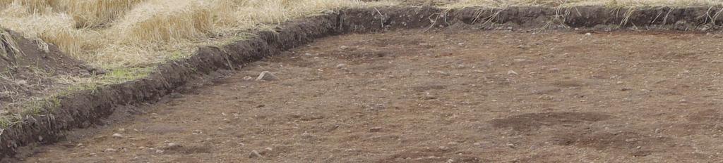
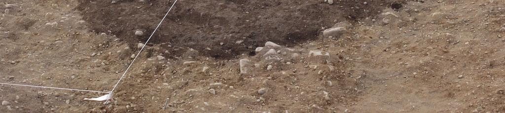
4 Figure 1: Transcription of cropmark complex RCAHMS and location of excavation trench - 3 -
5 Archaeological Background The palisaded enclosure lies within a rich archaeological region. The enclosure itself is c. 260m in diameter and is defined by an irregular line of postholes/pits depicted on the aerial transcription of the area. The evidence for this site shows the enclosure running in an irregular circle with broken and double lines of posts/pits in places. The western part of the enclosure runs outwith the main field and may have been lost due to erosion on the river terraces or utilised the natural steep slope in place of posts as a boundary. The cropmarks of the palisaded enclosure were first identified in Since then this site has been flown over numerous times by RCAHMS and others, expanding the scope and complexity of the cropmark complex. The large pit-defined enclosure at the heart of this complex has since its discovery been characterised as a palisaded enclosure. There are a small group of such sites in Scotland. Dunragit (Thomas, 2001), Meldon Bridge (Burgess 1976, Speak and Burgess 1999) and Blackshouse Burn (Lelong and Pollard 1998) have all been excavated to one extent or another, and shown to be large later Neolithic enclosures. A fifth site, Leadketty, is known only as a cropmark and is intriguingly situated just a few kilometres to the west of Forteviot. SERF excavations in 2007 confirmed that the Forteviot palisaded enclosure was indeed late Neolithic in origin, and defined by large oak post, but differences between all the sites indicate regional differences in the construction and probable function of these sites. A wide range of ancillary monuments have been recorded as cropmarks both within and on the outskirts of the enclosure some of which have been tested by excavation as part of SERF including henge monuments, cairns, timber circles and cist burials. These previous investigations indicate a high level of activity within this landscape from the later Neolithic into the Bronze Age, especially in the 3 rd millennium BC. Associated nearby cropmarks indicate this area was also utilised as a burial/cemetery site in the early medieval period (Poller 2007; Campbell and Gondek 2009). Aims Trench 5B was very specifically located to examine the southern end of the avenue, not investigated in 2007, and its junction with the palisaded enclosure boundary. The aims of this excavation were framed within the following research questions: Can a relationship between the double-ditched enclosure and the large palisaded enclosure be observed? What is the character of the postholes / architectural features of the palisaded enclosure at the junction between the avenue and the perimeter? How do these compare in form and character to the avenue postholes excavated in 2007 and those be exposed in Trench 7? How big were the posts? What wood type was used for the posts? Can any ancillary features directly associated with the architecture of the palisaded enclosure be identified at this junction? Were deposits placed in the postholes (prior to post erection and / or after the post was removed / decayed)? How does the deposition practice identified here compare with what was identified in the other excavated palisade enclosure postholes? Is there any evidence of a bank associated with the large enclosure here? Was the entrance a particular focus for deposition? - 4 -
6 What happened to the posts? Was the same strategy applied to all the posts? In the avenue, as excavated in 2007, some were burnt, some were removed and some rotted What is the nature of the cropmark large pit at the South end of the avenue? Is it contemporary with the enclosure (which would be very interesting given its location)? Methodology Trenches 5A and 5B essentially denote areas within a larger trench, 5, situated over a range of cropmarks across the northern side of the palisaded enclosure. Trench 5A focused on the double palisaded enclosure and is discussed in a separate report (James & Gondek 2010). The area covered by trench B was L-shaped, with the eastern half measuring 30m northsouth by 10m, and an extension measuring 20m east-west by 15m running from its southwest edge. The distinction between the two areas was based on a roughly arbitrary notional line running north-south, with area 5A to the east. Figure 2: Vertical image of Trench 5. The Trench 5B area is left (east) of the red line. Grid north is towards the bottom. The trench was opened using a tracked excavator. It was then cleaned by hand using hoes and subsequently trowels. A local grid was set up using Pentax Total Stations. Features revealed by cleaning were recorded using measured plan drawings, located using the local grid. Contexts were excavated by hand and recorded using pro-forma context sheets, photographs, measured section drawings and post-excavation plans. Samples were only taken from secure archaeological contexts. These samples consisted in the main of bulk soil samples, which will undergo flotation in order to recover any organic remains in order to provide dates for the contexts, and any palaeobotanical information that can be gained. Where large pieces of charcoal were present, these were collected by hand. Large quantities -5-
7 of burnt bone were also collected as samples as opposed to small finds as they tended to be spread throughout contexts. Small finds from secure contexts were recorded in three dimensions using the local grid where possible. Of the five avenue postholes revealed, four were excavated in half-section, with the fifth left unexcavated, as this was half-sectioned during the 2007 excavations. Of the four palisade postholes in 5B (the fifth being in 5A), two were excavated in half section, with the third excavated fully, and the fourth remaining unexcavated. The very large pit to the South of the avenue was quarter-sectioned due to its size and time constraints. One of the large pit features in the West of Trench 5B was excavated fully, with the other half-sectioned. All other excavated features were either half-sectioned or fully excavated, as dictated by time constraints. All excavated features backfilled by hand to maintain the integrity of the remaining half; the rest of the trench was backfilled by machine
8 Figure 3: Post-excavation plan of the trench - 7 -
, with layers of very fine sand in it, such as (5590).")
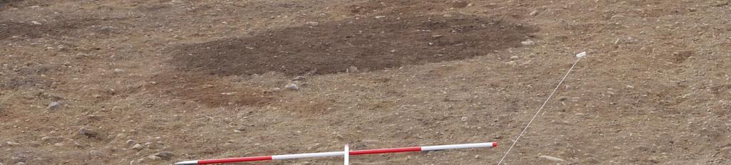
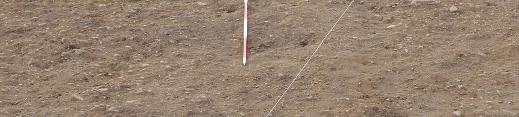
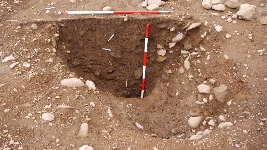
9 Results (Figure 3) Subsoil The predominant subsoil was light, yellow-orange gravel (5501). Underlying this subsoil in the east of the trench was pink boulder clay (5578), with layers of very fine sand in it, such as (5590). Large Pit at southern end of entrance avenue [5502] (Figure 4) Cropmarks indicated that a very large cut feature, or hollow, was located just to the south of the palisaded enclosure entrance within the enclosure. Upon excavation of the northwest quarter of this feature, it was shown to be a very large pit [5502], c7.1m in diameter, and up to 0.59m in depth. The pit had moderately sloping sides, with a flat base, and was c. 2.95m wide to the section at the base, which consisted of a natural clay layer (5578). The uppermost fill of this feature was a dark brown silt (5503). A piece of slag (SF 5505), and possible slag (SF 5506), were found in this context. As these were found only a few centimetres below the surface however, there is little that can be said about the significance of these finds, as at this depth, plough activity may still be a factor. Charcoal and a small amount of burnt bone were also found in this context. Below this was a light red-brown silt fill (5563), which contained a stone fill (5570) (see Figure 3). The lowest fill of this pit was a grey clay layer, (5571). This fill appears to have been the result of sedimentation onto the natural clay layer (5578), caused by water standing for long periods in the pit. A micro-morphology sample was taken from the primary fill and the natural clay in order to ascertain how long this sediment took to form, and to identify any pollen that may remain in the soil in order to help date this feature and reconstruct the environment at the time. Figure 4: Large pit [5502] during excavation Palisaded Enclosure Avenue Postholes [5504, 5506, 5526, 5530, 5542] The four most southerly postholes on the avenue were excavated, two on either side. A fifth [5542] was revealed within the trench, but this was left unexcavated it was half-sectioned in At this point the avenue is about 5m wide, with the posts roughly spaced 3m to 4m apart centre to centre
![The south-easternmost avenue posthole is [5504]. This feature was initially excavated by a 0.](/docs-images/94/118085673/images/10-0.jpg "5m wide sondage in order to identify any interrelationship with the large pit [5502], which is immediately adjacent.")
10 The south-easternmost avenue posthole is [5504]. This feature was initially excavated by a 0.5m wide sondage in order to identify any interrelationship with the large pit [5502], which is immediately adjacent. Once it was found that there was no such relationship, the western half of this feature was excavated. This posthole was 2.65m x 1.7m in plan, and was 1.5m deep, with vertical sides and a rounded bottom. There was no obvious ramp once excavated. The postpipe (5575) was c1m in diameter, and 0.7m depth, a consisted of a dark brown silt. A 0.6m wide pinky clay fill (5574) was found lining the southern half of the posthole, and was overlying river-rounded stones (5623), probably packing stones. There was a lens of charcoal and dark silty material (5573) in the southwest area of the posthole (see Figure 5). This lay just outside postpipe (5575), and c.15cm below the surface. (5626) was to the north of postpipe (5575), and consisted of dark brown silt with small stone inclusions. This fill may well be the same as (5627), which was also a dark brown silt fill with small stone inclusions, that lay between (5575) and (5574). Fill (5627) also came down onto rounded stones (5623), probably packing. The penultimate fill found was (5624), a pink-grey clay which underlay (5575). This fill may also be part of the postpipe, but as it was under the level of the water table, this may explain the different soil-type. The lowest fill of posthole [5504] was (5625), medium brown-grey sandy clay. This appears to be similar to the natural clay, but is slightly darker in colour, and contained charcoal inclusions. As this post does not appear to have been burned, this charcoal may represent deliberate deposition in the bottom of the posthole prior to the post being erected, or the charring of the base of the post to increase the life of the post. Figure 5: Charcoal lens in posthole [5504] - 9 -
11 Figure 6: East facing section of posthole [5506] The avenue posthole immediately the north of [5504] was [5506]. Due to the remnants of a palaeochannel running through the trench here, this posthole was not as clear as those on the western side of the avenue were. (This scenario was also encountered in 2007.) The eastern half of this feature was excavated. In plan this feature was 2.06m x 1.9m, and up to 1.3m deep. The sides of this feature were vertical on the SE and NW, but were stepped to the NE (see Figure 6). This has been interpreted as the ramp of this feature; the steps used by those digging the feature were then used to aid the erection of the post. The section string was moved during excavation of this feature in order to get a safe working space to reach the bottom of the feature. A context that was not visible in the final section was a lens of charcoal and dark silt (5660). This may have been a deposit of charcoal during the packing of the post. The postpipe of this feature is (5605), and was 0.8m wide, tapering to the bottom, and 0.8m deep. To the south of this postpipe lay packing fill (5665). This was a clay matrix that included numerous large, river-rounded stones. This is very similar to the clay and stone packing in posthole [5504]. To the north of the postpipe, the packing (5611) was quite dissimilar. (5611) was clayey silt, with just a few small stone inclusions. In this fill, the only example of Neolithic pottery was found (SF 5522). This may indicate deliberate deposition, but as there was only a very small fragment, this cannot be confirmed. (5686) lay to the north of (5611), and consisted of stony silt. This fill was either deliberate fill of the remainder of the posthole, or it was possibly slumping of material into the hole as the post rotted. The lowest fill of this feature was (5667). This sandy clay lay below the water table, as did the bottom of posthole [5504]. Similarly, this context contained significant quantities of charcoal, indicating the possibility of deliberate charcoal deposition prior to the post being erected. Posthole [5530] was located on the southern end of the western side of the avenue. In plan this feature was a long teardrop shape as a result of a very large ramp. Measuring 2.83m x 0.66m, and 1.16m deep, this posthole had the largest ramp of any of the avenue postholes. This ramp was filled with sandy silt with infrequent pebble inclusions (5531). The uppermost fill of the post area was (5618). This fill was visible on the surface as a subcircle containing a light gravely fill; in section this was triangular shaped. It seems that this fill is the result of the post rotting, and the natural gravel filling in the hollow created. Immediately under this fill in the south of this feature, was a small clay deposit. This may be the remnant of clay packing
12 for the post that stood in this posthole. Much of the posthole fills appear to have been disturbed by an animal burrow. Pipes of charcoal fill (5668) led from almost the surface down to where the deposit appears to have originated; around 0.4m below the surface. As a result, the boundary between the ramp fill (5531) and the main fill (possible postpipe) (5669) is indistinct. This main fill extends from below (5618) and (5668) to the bottom of the posthole, with only (5670), charcoal-rich silty fill seemingly lying within this fill just a few centimetres from the base of the fill. This may be another example of deliberate charcoal deposition prior to post erection. The final avenue posthole excavated was [5526]. This posthole had no visible ramp. This subcircular feature had a U-shaped profile with vertical sides, and was 1.5x 1.4m in plan and 0.88m deep. There was a 0.2m thick, light orange-brown silt fill at the top of the postpipe. This overlaid the main postpipe (5576), which was defined by a dark brown silt fill 0.74m wide and 0.85m deep. The fill in the south of the posthole was (5615), which was light orange-brown silt with very frequent small stone inclusions. This fill may be deliberate packing of the post using the natural soil, which this fill is very similar to, or it may be the result of slumping of natural into the posthole. The fill in the north of the posthole (5577) was fairly similar to (5615), though it was darker in colour, and can be interpreted in the same way. The lowest fill of this posthole was (5601); dark brown silt with a high frequency of charcoal. Once again, this seems to be evidence of charcoal deposition in the base of an avenue posthole prior to the post being erected. Palisade Northern Boundary Postholes [5613, 5518, 5538, 5592] Five palisade postholes were revealed in Trench 5, four of which fell within the 5B area (see James & Gondek 2010). Of these four, one, [5613], was not excavated. This was due to the damage that had been caused to this feature by a modern drainage feature [5520], which also bisected palisade posthole [5518] (see Figure 7), as well as another area of disturbance to the south of [5613]. At this point in the boundary, the posts are set some 6m apart, which is more or less the same as was found in Trench 7, and wider spaced than posts on the avenue. Posthole [5538] was difficult to excavate. Due to incomplete weathering out of this feature until about 10 days into the excavation season, the ramp of this feature had not been identified despite excavation having commenced on the posthole. However, the section line was moved in order to rectify this once the ramp became apparent. The upper postpipe fill (5539) was fairly hard to distinguish from the lower postpipe fill (5549), and could only be done so during excavation. Fill (5539) was 0.38m thick and (5549) c.0.8m deep. This posthole was the only one excavated that had an inclination, and as a result there seems to be packing to the east of the postpipe (5591) that was at the bottom of the posthole, but does not extend to the top of the feature. This dark brown silty sand contained the only example of worked stone from trench 5B, in the form of a tested and abandoned core (SF 5518) found at the base of this fill. This fill also contained a small amount of burnt bone. This indicates that there may have been deliberate deposition within the postholes of the palisade. The ramp had an upper slumped fill (5548), which contained a few large stones. The lower ramp fill (5678), was orange-brown silt, and contained lenses of clay similar to that lining some of the avenue postholes. This fill also contained the river-rounded packing stones (5679) that were at the base of this feature
![Figure 7: Northeast facing section of [5518] Posthole [5518] was bisected by fairly shallow modern drainage feature [5520] (see below). This ramped posthole measured some 1.6m by 1.](/docs-images/94/118085673/images/13-0.jpg "05m, with maximum depth of 1.2m.")
13 Figure 7: Northeast facing section of [5518] Posthole [5518] was bisected by fairly shallow modern drainage feature [5520] (see below). This ramped posthole measured some 1.6m by 1.05m, with maximum depth of 1.2m. The upper fill of the ramp on the NW side of the feature (5662) was medium orange-brown sandy silt, with gravel and infrequent stone inclusions, as well as several pink clay lenses, as in the ramp fill of [5538]. The lower ramp fill (5672) was darker orange-brown sandy silt, also with gravel and infrequent stone inclusions, though also had charcoal inclusions towards the bottom of the context. Within this charcoal was a single example of a charred nutshell. The postpipe (5572) was a very homogenous dark brown silt fill, with charcoal inclusions towards the bottom of the context. The packing (5519) around the postpipe was a sandy silt matrix containing large packing stones 0.1m to 0.35m, concentrated towards the top of the context (see Figure 8). Charcoal and lenses of pink clay were also found in this context. The lowest fill in [5518] was (5675). This fill had significant quantities of charcoal within it, once again indicating deliberate deposition of charcoal prior to post erection
![Figure 8: (5519) packing stones Posthole [5592] was a very difficult feature to define and excavate, in part due to the posthole apparently cutting an earlier feature that had not been identified in](/docs-images/94/118085673/images/14-0.jpg "plan. Posthole [5592] measured 1.2m across in plan, with a maximum depth of 1.12m. There was no evidence for a ramp in [5592].")
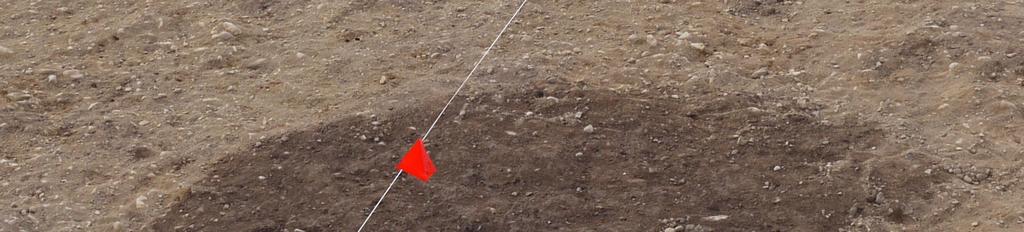
14 Figure 8: (5519) packing stones Posthole [5592] was a very difficult feature to define and excavate, in part due to the posthole apparently cutting an earlier feature that had not been identified in plan. Posthole [5592] measured 1.2m across in plan, with a maximum depth of 1.12m. There was no evidence for a ramp in [5592]. The possible postpipe of [5592] was (5593), dark orangebrown sandy silt with flecks of charcoal. This was distinct from the upper packing fill (5683), which was a medium yellow-brown sandy silt containing frequent rounded pebbles. This fill may have been the natural used as packing. Below (5593), were packing stones (5604). The packing appeared to have tumbled down the sides and towards the bottom, possibly after the post was removed, or as it rotted. Below this stone fill was (5684), medium yellowbrown silt containing charcoal and very infrequent stones. The lowest fill (5685) contained notable amounts of charcoal, as with the other postholes. Little can be said about the feature which [5592] cut due to the difficulty we had in identifying the complex nature of this feature in plan. However, it is possible that [5562] represents an earlier post replaced more or less in the same location. Pyre pits [5512, 5514] Over Trench 5, three large oval pits full of burnt material were identified in an area between the palisaded enclosure and double palisaded structure. Two are described here, while the other, in area 5A, is discussed elsewhere (James & Gondek 2010)
![Figure 9: North facing section of [5512] The most northerly of the three features was a large pit [5512] that was 2.5m by 1.9m in plan, and up to 0.56m deep.](/docs-images/94/118085673/images/15-0.jpg "The pit had shallow sides, slightly steeper on the eastern side, with the base relatively level but sloping down to the east (see Figure 9).")
15 Figure 9: North facing section of [5512] The most northerly of the three features was a large pit [5512] that was 2.5m by 1.9m in plan, and up to 0.56m deep. The pit had shallow sides, slightly steeper on the eastern side, with the base relatively level but sloping down to the east (see Figure 9). The upper fill of this pit (5513) was extremely charcoal rich, with individual pieces of charcoal at up to 10x7x5cm in size. There was also a significant amount of burnt bone. Though these were spread throughout the fill, there were some concentrations within the fill. The lower fill (5598) of this pit was a 30cm deep dump of small rounded stones, maximum size 17x15x7cm. 10m to the south, a second similar, but more complex pit was found. This pit [5514] was very large, 3.5m by 2.4m in plan, and 0.56m deep. Like [5512] this pit had a fairly flat bottom, but the sides were steeper to the west, and shallower to the east. The upper fill of this pit, (5515), was charcoal-rich silt with very infrequent stone inclusions. The charcoal was in much smaller pieces than the upper fill (5513) of [5512], and though there was also burnt bone found in this context, it was again in smaller quantities, and there did not seem to be any concentrations. A small cup-marked stone (SF 5519) was found in this fill. The lower fill (5600) of the pit had a much denser concentration of charcoal than (5515 in pit [5512]. A larger cup-marked stone (SF 5520) was found in this context
![Figure 10: North facing section of [5514] Pit [5514] cut a tree-throw [5516] towards the northeast end of the pit (see Figure 10).](/docs-images/94/118085673/images/16-0.jpg "This large feature had a single fill, (5517), which yet again had within it a cup-marked stone (SF 5521) indicating that potentially this tree was felled a short time before the pyre pit was situated")
![here. Figure 11: West facing section of [5516] and [5514] Pit [5514] also probably cut a second, smaller pit. This feature [5522] was a pit, 1.7 by 1.6m in plan, with a single gravely fill (5523).](/docs-images/94/118085673/images/16-1.jpg "In plan this pit looked reasonably rectangular, but once excavated, it seemed more sub-circular. The sides of this pit were moderately steep all the way around, and the pit went to a depth of 42cm.")
16 Figure 10: North facing section of [5514] Pit [5514] cut a tree-throw [5516] towards the northeast end of the pit (see Figure 10). This large feature had a single fill, (5517), which yet again had within it a cup-marked stone (SF 5521) indicating that potentially this tree was felled a short time before the pyre pit was situated here. Figure 11: West facing section of [5516] and [5514] Pit [5514] also probably cut a second, smaller pit. This feature [5522] was a pit, 1.7 by 1.6m in plan, with a single gravely fill (5523). In plan this pit looked reasonably rectangular, but once excavated, it seemed more sub-circular. The sides of this pit were moderately steep all the way around, and the pit went to a depth of 42cm. The relationship between [5514] and [5522] was not entirely clear as they only clipped one another, and there was a gradation of change between the two features fills (see Figure 11)

17 The third pyre pit sat to the west of both of these, about half way between them, so that together they formed a triangular setting measuring 10m by 8m by 8m. [5512] sits just offset from the palisade enclosure boundary. Smaller Postholes A range of other postholes and pits were found within the Trench 5B area. A sample of these was excavated. Semi-circular post setting [5540, 5564, 5566, 5568, 5613, 5646] At the western edge of the main trench, there was what seemed to be a small semi-circular setting of posts (see Figure 12) that included palisade posthole [5613] as part of the setting. If this is indeed a setting, this may mean that it was established at the same time as the palisaded enclosure, or when it was still visible. The setting consisted of at least three possible posts, with a tree throw in the position of where another post would be expected, were this a circular setting. There is also a possible fourth post associated with this feature, though it would be a little off-line. Feature [5564] was the southernmost of the possible postholes. This feature was fairly amorphous in plan, with a slight NW-SE alignment. It measured 1m by 0.58m and 0.38m deep. The upper fill was (5565); at only 0.05m thickness, this deep dark brown silty sand was most likely remnants of the topsoil. The other upper fill (5617) was restricted to the northwest end of the feature; this was medium yellow brown silt, only 0.06m deep. The rest of the cut was filled by (5619), a medium orange-brown coarse sand and gravel fill, very similar to the natural, but very compacted. There was no evidence for a postpipe in this cut, so any post may have been removed, allowing the natural soil to wash in, with only a little of possible original fill remaining, with a few stones that may be the remnants of packing. This may also have been a pit. Figure 12: Arc of posts, or semi-circular post setting Feature [5566] was the next possible posthole in the series (moving north and clockwise). This was oval in plan at 0.84m by 0.69m and U-shaped in section, with a depth of 0.21m. There was a single fill (5567), which was a dark brown silt with c. 20% stone inclusions at 5x4x3cm, with one stone 18x15x2cm although a distinct postpipe was not evident, the

18 presence of the stones could indicate they were remnants of packing for a post (see Figure 13). The third feature [5568] was quite difficult to differentiate from the natural, and was similar in nature to [5566]. The fourth feature of the setting was palisaded enclosure boundary posthole [5613]. Figure 13: Small post or pit [5566] on semi-circular setting The most northerly feature on this arc was a tree throw [5540]. This feature was not fully exposed in the trench, but what was visible was a 1.2m by 0.7m banana shaped cut, that had a U-shaped profile, and was 0.32m deep. The upper fill (5541) was dark orange-brown silt with 15% small stone inclusions. The lower fill (5671) was light yellow-brown sandy gravel with frequent small stones, much like the natural. This is not surprising, as the first fill of this feature would likely have been clods of soil and gravel adhering to the roots of the fallen tree falling back into the hollow. Unfortunately, no charcoal was found with which to date this feature. The posthole that may be part of the setting, but would be a little off-line was [5646]. Amorphous in plan, 1.05m by 0.97m, this feature resolved itself into a clear posthole, 0.46m deep with postpipe (5647) and packing to the NW (5676) and the SE (5677). Sloping steeply to the SE and moderately to the NW, in profile this posthole was pot and handle shaped (see Figure 14). The postpipe was 0.3m across, and consisted of dark red-brown clay silt. The packing to either side was most likely the same context, but was assigned a context number for each side it appeared on in section. Both were friable, light orange-brown gravel
![Figure 14 Section through possible posthole [5646] Possible linear settings / features near end of avenue There were several small features around the intersection between the palisade and entrance](/docs-images/94/118085673/images/19-0.jpg "avenue. At times these features appeared to resolve themselves into linear settings of posts, or small pits.")
19 Figure 14 Section through possible posthole [5646] Possible linear settings / features near end of avenue There were several small features around the intersection between the palisade and entrance avenue. At times these features appeared to resolve themselves into linear settings of posts, or small pits. Only after radiocarbon dating the small amounts of charcoal found, however, can we begin to tease out individual settings from the general pattern. Cut [5534] was sub-rectangular in plan, and U-shaped in section. About 0.5 x 0.25m in plan, this feature was 0.25m deep. This cut was filled by a single context, (5535). This was dark grey-brown silt with very infrequent gravel inclusions. This feature may be the remains of a small posthole. Feature [5640] was the cut for a small posthole with a ramp. This feature was amorphous in plan, but roughly V-shaped in section, sloping to a maximum depth of 0.22m, with a possible ramp to the west. A postpipe was identified (5641). It was c.0.25m in diameter, and 0.25m deep, and defined as a medium red-brown silt. The fill of the ramp (5688) (0.18m deep, 0.55m long) was very similar to the postpipe; medium red brown silt. However, the ramp fill had both larger and smaller stone inclusions (10x5x4cm and 4x5x3cm respectively). A fill (5687) to the east of the feature was a dark red brown silt with stone inclusions up to 10x8x5cm and gravel, probably packing. Feature [5536] was sub-oval in plan, measuring 1.15m x 0.85m, and 0.24m deep with a U- shaped section. This feature was most likely the cut for a small posthole. This feature had two fills: (5537) and (5663). The former was light orange-brown silt with gravel inclusions, and found down to 0.24m depth and may have represented a postpipe. Fill (5663), a dark brown silt with no inclusions, may have been the remains of the packing. Feature [5656] was not a posthole, but may have been a small pit. This oval feature was only 0.14m deep and in plan measured 0.93m by 0.6m. The upper fill (5657) was dark brown silty sand with small stone inclusions c 15% of the total and just 4.5cm deep. The lower fill was light red brown sand with stone inclusions c 15%
![Feature [5654] was oval in plan and flat-bottomed with sloping sides. This feature was 1m by 0.8m in plan, but was only 0.21m deep. The single fill (5655) was a dark brown silt with c.](/docs-images/94/118085673/images/20-0.jpg "20% stone inclusions. Figure 15 Typical features in the avenue junction area pre-excavation Feature [5648] was oval in plan, measuring 0.9m by 0.6m. In profile, it was a shallow, 0.")
20 Feature [5654] was oval in plan and flat-bottomed with sloping sides. This feature was 1m by 0.8m in plan, but was only 0.21m deep. The single fill (5655) was a dark brown silt with c.20% stone inclusions. Figure 15 Typical features in the avenue junction area pre-excavation Feature [5648] was oval in plan, measuring 0.9m by 0.6m. In profile, it was a shallow, 0.19m deep U-shaped cut. The upper fill (5649) was a 4cm deep and spread over an area some 0.4m across. It was a dark brown silt, which overlay (5659). This 0.12m deep fill was not homogenous, consisting of medium orange brown silt with lenses of darker silt towards the bottom of the fill. It is unclear if this was a pit, or a heavily truncated posthole. Modern Agricultural Features Other than the ephemeral remnants of modern plough furrows that were removed by initial cleaning of the trench, there were two agricultural features present in trench 5B. Drainage feature [5520] bisected palisade posthole [5518] (see Figure 15). Visible only under specific weather and lighting conditions, this feature was not visible at all by the end of the excavation. It ran for at least 20m across the trench. As part of the excavation of [5518], [5520] was exposed in section, and was found to be roughly triangular in profile, 25cm wide at the surface, tapering to a point at a depth of 15cm. The single fill of this (5521) was identical to the natural gravely soil. The second agricultural feature revealed in the trench was [5544]. This was a shallow, 10cm deep plough furrow, likely medieval. Running for 7m in the trench, this feature was 1m across at the widest point. A slot across this feature revealed a U-shaped profile, filled with dark brown silt. Several pieces of modern glass and pottery were found in this context, indicating that the fill of this cut is relatively recent. Tree Throws Three tree throws were excavated in trench 5B, while it is likely others were present within the area, although differential drying made these very difficult to identify. Two of these, [5516] and [5540], have been discussed above. The third, [5524], was a large tree throw with 2.65m by 1.15m exposed in the trench, which may have represented as little as half of the
21 full extent of the feature. A slot was dug across this feature in order to ascertain the size, and whether or not there was any deposition in this feature, which it was found there was not. No datable evidence was found either. Feature [5508], which lay within the entrance avenue may well have been a tree throw as well. Roughly banana shape in plan, this small 1.55m by 0.9m feature had clay silt fill (5574) with several small stone inclusions. This feature may also be a small, amorphous pit feature like those that were identified during the excavations at the avenue in 2007 (Noble & Brophy 2008). There was no evidence for any deposition in this feature, and there was no dateable material found in the fill. Square Posthole Pit One of the most unusual features in trench 5B was shallow, rectangular feature [5510], and the possible posthole [5546] that became visible inside it as a result of a few dry days. In plan, [5510] was assumed to be a fairly modern animal burial due to its rectangular shape and regular edges. However, this was not found to be the case, and the upper fill (5511) was in fact only 0.05m deep. This dark brown silt was likely remnants of the topsoil that had silted into a slight hollow that happened to be roughly rectangular. [5546], once halfsectioned, appeared to be a small post-hole or pit. There was no evidence for a post-pipe. The upper fill (5547) was probably the same as (5511) as it is identical in morphology. The next fill (5606), was a 0.08m deep light orange-brown silt with very infrequent gravel inclusions. Below this was (5607), dark brown gravely coarse silt with more frequent gravel inclusions, again 0.08m deep. The lowest fill, (5610), was a light brown sandy silt with gravel, stone and pebble inclusions. This fill was deeper than those above at 0.14m at its deepest point. This unusual feature was located just to the west of the entrance avenue. Discussion At this stage, before post-excavation analysis and dating has been undertaken, the interpretations of the site, and answers to the research questions, are necessarily provisional. Can a relationship between the double-ditched enclosure and the large palisaded enclosure be observed? No direct stratigraphic relationship could be identified. Initial indications in terms of the few diagnostic artefacts found suggest the late Neolithic palisaded enclosure was the earlier of the two. The double-ditched enclosure, like many other features in the field, seems to respect the boundaries of the palisaded enclosure, indicating it was still visible in the landscape when the round enclosure was constructed. What is the character of the postholes / architectural features of the palisaded enclosure at the junction between the avenue and the perimeter? The postholes at the junction between the avenue are both larger than the posts around them. Both posts respect the large pit in the entrance, or perhaps the big pit respected these posts. There appears to be a concentration of other features at this junction, although the nature of these features and their relationships remains unclear. How do these compare in form and character to the avenue postholes excavated in 2007 and those be exposed in Trench 7? The postholes are roughly similar to those excavated elsewhere in the project. In all cases, however, there are differences. The postholes of 5B all have charred material at the base of the posthole, which was not the case in the rest of the avenue or elsewhere. Like the
22 postholes elsewhere, there are variations in post removal strategy, ramp presence and direction and posthole size. How big were the posts? The size of the post-pipes should indicate the rough size of the posts used in the boundary postholes up to 1m in diameter which suggests these were substantial posts. Post depth indicates posts could have been in the order of 6m in height, although this is a minimum estimate due to plough truncation. The presence of ramps also indicates these were substantial posts. What wood type was used for the posts? Analysis of the charcoal collected will be needed to assess the types of wood used. Typically, we would expect the wood type to be oak, as was the case at the entrance. Can any ancillary features directly associated with the architecture of the palisaded enclosure be identified at this junction? There may be a few smaller settings of posts/ and/ or pits around this entrance area, indicating that this was a site of continuing importance. No evidence of features between palisade posts was found, although it is possible one post was replaced. The semi-circular setting of ephemeral postholes / pits may indicate an attempt to support a large post. Were deposits placed in the postholes (prior to post erection and/ or after the post was removed/ decayed)? All postholes forming the palisade entrance avenue and the boundary have deposits of charcoal at the bottom of the postholes. This was placed in the postholes prior to the posts being erected in most cases, as there are distinct postpipe remains of the posts in situ. (This may also be related to post-base charring.) There is one example of Neolithic pottery, one example of struck stone, one example of charred nutshell and some burnt bone found among the postholes. Any of these may have found their way into the postholes by accident, or through deliberate deposition. How does the deposition practice identified here compare with what was identified in the other excavated palisade enclosure postholes? This area appears to have a slightly higher concentration of deposition than the other two areas of the monument excavated. Overall, the palisaded enclosure is associated with very few artefacts, so it is interesting that pottery was found within a posthole near the southern end of the avenue. Is there any evidence of a bank associated with the large enclosure here? There was no indication of any bank associated with the enclosure boundary, if any existed it is possible that this has been lost with modern plough truncation, nothing was apparent in the section of the field boundary that was cleaned up. Nonetheless, the digging of such large postholes would have generated a lot of spoil. Potentially later structures seem to exist just outwith the enclosure, perhaps hinting that it was marked in some way more durable than wood. Was the entrance a particular focus for deposition? The only piece of Neolithic pottery that was found in this trench was in avenue posthole [5506]. The only possible worked lithic found, a struck and discarded core was found in palisade posthole [5538]. However, the burnt bone and nutshell were not in avenue
23 postholes. Nonetheless, such postholes could be viewed as equivalents to henge terminals, that is places associated with transformation and entrance. What happened to the posts? Was the same strategy applied to all the posts? In the avenue, as excavated in 2007, some posts were burnt, some were removed and some rotted. At least a few of the postholes examined in 2010 suggested posts rotted in situ, as there is clear evidence for postpipes, and material slumping onto rotting posts. There is no evidence for posts burning in situ, as the charcoal found is concentrated only towards the bottoms of the features. There may be one example of a post being removed and replaced. What is the nature of the cropmark pit at the South end of the avenue? Is it contemporary with the enclosure (which would be very interesting given its location)? This feature was a relatively shallow pit c. 8m in diameter that was dug down onto a layer of natural clay subsoil. The lowest fill was indicative of natural silting up under waterlogged conditions. This will be investigated in detail, as a micro-morphology sample of this intersection was taken. The pit does seem do be relatively contemporaneous with the avenue, as the two innermost postholes of the avenue respect the edge of the pit to within less than 1m. It is tempting to see this as a watery place right at the entrance to the palisaded enclosure, as even a small amount of rain would result in waterlogging of this feature. Nonetheless, its date and any other information must await post-excavation analysis. Conclusion The postholes of the palisaded enclosure and entrance avenue share many similarities, but also many differences. They all have evidence for charcoal at the bases of the postholes; this may be due to deposition prior to the posts being erected, or evidence of the charring of the bases of the timbers to increase their longevity. However, their sizes differ greatly, from c. 2.5m in diameter and up to 1.5m deep, to only 1.5m in diameter and 0.88m deep. Most, but not all, of the postholes show evidence for a ramp. The estimated diameter of the posts does not appear to bear any relation to the presence of a ramp. For example, one of the narrowest postholes [5518] has one of the longest ramps. This suggests that although this may have been a relatively narrow post, it may also have been one of the tallest. This is good evidence that these posts were not uniform in size, and the visual impact of each would have been unique. This is entirely within keeping with finds associated with other parts of the palisaded enclosure. The other, smaller features around the palisaded enclosure indicate that this monument was a focus for secondary construction. The possible semi-/ circular post setting, and the possible linear settings may represent shrines or something similar. It is also possible that these are not contemporary with Neolithic activity here, or indeed may be associated with repairs of amendments to the original enclosure. The three large pits possibly related to a pyre may represent the earliest features in the trench, though this can only be concluded with radiocarbon dating. There appears to have been no in situ burning within these pits, suggesting the material was dumped in from a burning event happening nearby (perhaps cremations, given the presence of cremation cemetery, dated to c cal BC, within 150m to the south). The deposition of pecked stones in both [5514] and tree throw [5516] is perhaps one of the most important finds of this trench. The comparable deposition indicates a connection between a tree throw and a pit, both chronologically and ideologically. This is intriguing, as one way to clear woodland is to topple a tree and burn the root pad, which may have generated the large quantities of
24 burnt material found in this particular pit. The burning of trees, and perhaps people, were interconnected here. The excavations at Trench 5B revealed a place of ongoing importance in prehistory, with the same site revisited and added to repeatedly over time. The finds serve to add another layer of complexity and importance to this area of Scotland as one of the most important cultural, spiritual or ideological centres for a period of several thousand years. Acknowledgements The author would like to thank the landowners and Historic Scotland for their permission to excavate on this site. The project was partly sponsored by the British Academy (LRG: 45610); Historic Scotland (Archaeology Funding Programme) and the Universities of Glasgow and Aberdeen. The research of SERF is benefited by partnerships with the Royal Commission on the Ancient and Historical Monuments of Scotland ( and Perth and Kinross Heritage Trust ( Thanks also go to the directors and staff of SERF for their support and advice throughout the season. In particular, thanks go to Alex Partridge who spent a good deal of time assisting and supervising. Lorraine McEwan prepared the line drawing. Final thanks go to all the students and volunteers on Trench 5B, who did all the hard work. References Burgess, C 1976 Meldon Bridge: a Neolithic defended promontory complex near Peebles in Burgess, C and Miket, R (eds) Settlement and Economy in the Third and Second Millenia B.C., , BAR 33, Oxford. Lelong, O and Pollard, T The excavation and survey of prehistoric enclosures at Blackshouse Burn, Lanarkshire Proceedings of the Society of Antiquaries of Scotland 128, Noble, G and Brophy, K 2007 Forteviot, Perthshire: Excavations at the Entrance Avenue of the Neolithic Palisaded Enclosure 2007, Interim Report and DSR. Speak, S and Burgess, C 1999 Meldon Bridge; a centre of the third millennium BC in Peebleshire, Proceedings of the Society of Antiquaries of Scotland 129, Thomas, J 2001 Neolithic enclosures: reflections on excavations in Wales and Scotland, in T. Darvill and J Thomas (eds) Neolithic enclosures in Atlantic NW Europe, 132, 43, Oxbow, Oxford
25 Appendices i) Contexts Context Number Area Type Description and Interpretation 5500 Deposit Topsoil 5501 Deposit Natural, light yellowy-orange gravel Cut of large pit to the South of the entrance avenue of the palisaded 5502 Q, R, W, X Cut enclosure 5503 Q, R, W, X Fill Upper fill of large pit [5502] 5504 K/L Cut Cut of SE-most possible avenue posthole 5505 NOT USED 5506 E/F/K/L Cut Cut of posthole in the entrance avenue of palisaded enclosure 5507 NOT USED 5508 K Cut Cut of amorphous feature in the centre of the avenue- possible tree throw 5509 K Fill Fill of possible tree throw [5508] 5510 J Cut Cut of rectangular shallow scoop around, or possibly cut by, posthole [5546] 5511 J Fill Upper silty fill of shallow scoop [5510], This fill may be the same as (5547), some topsoil remnants 5512 G, H Cut Cut of large pit, possibly used for pyre dumping 5513 G, H Fill Upper Fill of [5512], possible pyre dump 5514 O/U Cut Cut of large pit, steep sided pit roughly 0.5m deep which shelves off and becomes shallower to the NE where the sides also become less steep, changing from >80 to O/U Fill Fill of [5514], homogenous in nature with regular charcoal and burnt bone. Some stones of various sizes throughout O Cut Cut of possible tree throw to N of [5514] 5517 O Fill Fill of [5516] 5518 S, T, Z Cut Cut of palisade posthole with ramp- possibly stepped 5519 S, T, Z Fill Fill of [5518], Packing material for post pipe (5572) 5520 S/T/Y/Z Cut Cut of linear feature (possible field drainage) 5521 S/T/Y/Z Fill Fill of [5520] 5522 T Cut Cut of feature to south of [5514] 5523 T Fill Fill of [5522] 5524 B/C Cut Cut of tree throw 5525 B/C Fill Fill of [5524] 5526 J Cut Cut of avenue posthole 5527 NOT USED 5528 Cut Cut of possible tree throw to north of [5502], Unexcavated 5529 Fill Fill of [5528], Unexcavated 5530 J/P/Q Cut Cut of avenue posthole and ramp 5531 J/P/Q Fill Fill of [5530] 5532 J/P/Q Cut Cut of feature to east of [5502]- small posthole 5533 P Fill Upper silty fill of possible small posthole [5532] 5534 P Cut Cut of possible posthole 5535 P Fill Fill of possible posthole [5534] 5536 I/J/O/P Cut Cut of shallow pit/ poss posthole
26 5537 I/J/O/P Fill Lower fill of shallow pit/ possible posthole [5536] 5538 O/P Cut Cut of palisade posthole and ramp 5539 O/P Fill Upper fill of palisade posthole [5538] 5540 Cut Cut of tree throw 5541 Fill Fill of [5540] 5542 D Cut Cut of probable avenue posthole, Unexcavated 5543 Fill Fill of [5542], Unexcavated 5544 B/H/I/N/O Cut Cut of possible plough furrow 5545 B/H/I/N/O Fill Fill of [5544] 5546 J Cut Cut of possible posthole 5547 J Fill Fill of [5546] 5548 O/P Fill Light sandy and pebbly fill of [5538] 5549 O/P Fill Darker fill than (5548), fill of [5538] 5550 Z Cut Sub-circular pit or animal burrow 5551 Z Fill Upper fill of shallow scoop/animal burrow [5550] 5552 NOT USED 5553 Z Cut Cut of shallow scoop/pit with silty fill 5554 Z Fill Silty fill of shallow scoop/pit [5553] 5555 Z Cut Cut of feature, Unexcavated 5556 Z Fill Fill of [5555]*Unexcavated* 5557 Z Cut Cut of feature *Unexcavated* 5558 Z Fill Fill of [5557]*Unexcavated* 5559 Z Cut Cut of very small stakehole(?) *Unexcavated* 5560 Z Fill Fill of [5559]*Unexcavated* 5561 Z Cut Cut of stakehole(?) *Unexcavated* 5562 Z Fill Fill of [5561]*Unexcavated* 5563 Q Fill Fill underlying (5503) in [5502] 5564 T/U Cut Cut of possible posthole in semi-circular setting 5565 T/U Fill Upper fill of [5564] possible plough soil remnants T Cut Cut of amorphous feature 5567 T Fill Fill of [5566], fill of possible posthole/ small pit within semi-circular setting including palisade posthole [5613] 5568 T Cut Cut of amorphous feature 5569 T Fill Fill of [5568] 5570 Q Fill Stone fill/ dump set into silty layer (5563) in pit [5502] 5571 Q Fill Clayey fill of [5502], Bottom fill of large pit [5502]. Possible organic deposition from standing water in the pit S/T/Z Fill Postpipe of palisade posthole [5518] 5573 K/L Fill Lens of charcoaly material in avenue posthole [5504], to the SW of postpipe fill (5575) 5574 K/L Fill Packing, pinky clay fill of posthole [5504] 5575 K/L Fill Post pipe of avenue posthole [5504] 5576 J Fill Darker fill of [5526] under (5575) 5577 J Fill Fill under (5576), packing and natural sand 5578 Q Deposit A natural clay layer underneath the large pit [5502] 5579 O/P Fill Pinky clay fill of posthole [5538] found under group of large stones, part of packing on the ramp of the posthole 5580 A/C Cut Amorphous cut feature 5581 A/C Fill Fill of [5580]
Forteviot, Perthshire: Excavations at the Entrance Avenue of the Neolithic Palisaded Enclosure Interim Report and Data Structure Report
 Forteviot, Perthshire: Excavations at the Entrance Avenue of the Neolithic Palisaded Enclosure 2007 Interim Report and Data Structure Report by Gordon Noble and Kenneth Brophy Table of Contents Summary
Forteviot, Perthshire 2008: Excavations of a henge monument and timber circle. Data Structure and Interim Report. by Gordon Noble and Kenneth Brophy
 Forteviot, Perthshire 2008: Excavations of a henge monument and timber circle Data Structure and Interim Report by Gordon Noble and Kenneth Brophy Summary This interim report will describe the provisional
An archaeological evaluation at 16 Seaview Road, Brightlingsea, Essex February 2004
 An archaeological evaluation at 16 Seaview Road, Brightlingsea, Essex February 2004 report prepared by Kate Orr on behalf of Highfield Homes NGR: TM 086 174 (c) CAT project ref.: 04/2b ECC HAMP group site
New Composting Centre, Ashgrove Farm, Ardley, Oxfordshire
 New Composting Centre, Ashgrove Farm, Ardley, Oxfordshire An Archaeological Watching Brief For Agrivert Limited by Andrew Weale Thames Valley Archaeological Services Ltd Site Code AFA 09/20 August 2009
ARCHAEOLOGICAL EVALUATION AT BRIGHTON POLYTECHNIC, NORTH FIELD SITE, VARLEY HALLS, COLDEAN LANE, BRIGHTON. by Ian Greig MA AIFA.
 ARCHAEOLOGICAL EVALUATION AT BRIGHTON POLYTECHNIC, NORTH FIELD SITE, VARLEY HALLS, COLDEAN LANE, BRIGHTON by Ian Greig MA AIFA May 1992 South Eastern Archaeological Services Field Archaeology Unit White
Forteviot Pictish Cemetery Excavation Data Structure Report. By Ewan Campbell
 Forteviot Pictish Cemetery Excavation 2010 Data Structure Report By Ewan Campbell Table of Contents Summary 2 Introduction 2 Aims 2 Methodology 2 Results 4 Geology 4 Post-Cemetery Agricultural Activity
3. The new face of Bronze Age pottery Jacinta Kiely and Bruce Sutton
 3. The new face of Bronze Age pottery Jacinta Kiely and Bruce Sutton Illus. 1 Location map of Early Bronze Age site at Mitchelstown, Co. Cork (based on the Ordnance Survey Ireland map) A previously unknown
7. Prehistoric features and an early medieval enclosure at Coonagh West, Co. Limerick Kate Taylor
 7. Prehistoric features and an early medieval enclosure at Coonagh West, Co. Limerick Kate Taylor Illus. 1 Location of the site in Coonagh West, Co. Limerick (based on the Ordnance Survey Ireland map)
Church of St Peter and St Paul, Great Missenden, Buckinghamshire
 Church of St Peter and St Paul, Great Missenden, Buckinghamshire An Archaeological Watching Brief for the Parish of Great Missenden by Andrew Taylor Thames Valley Archaeological Services Ltd Site Code
An archaeological evaluation at the Lexden Wood Golf Club (Westhouse Farm), Lexden, Colchester, Essex
, Lexden, Colchester, Essex") An archaeological evaluation at the Lexden Wood Golf Club (Westhouse Farm), Lexden, Colchester, Essex January 2000 Archive report on behalf of Lexden Wood Golf Club Colchester Archaeological Trust 12 Lexden
An archaeological evaluation at the Lexden Wood Golf Club (Westhouse Farm), Lexden, Colchester, Essex January 2000 Archive report on behalf of Lexden Wood Golf Club Colchester Archaeological Trust 12 Lexden
Former Whitbread Training Centre Site, Abbey Street, Faversham, Kent Interim Archaeological Report Phase 1 November 2009
 Former Whitbread Training Centre Site, Abbey Street, Faversham, Kent Interim Archaeological Report Phase 1 November 2009 SWAT. Archaeology Swale and Thames Archaeological Survey Company School Farm Oast,
Grim s Ditch, Starveall Farm, Wootton, Woodstock, Oxfordshire
 Grim s Ditch, Starveall Farm, Wootton, Woodstock, Oxfordshire An Archaeological Recording Action For Empire Homes by Steve Ford Thames Valley Archaeological Services Ltd Site Code SFW06/118 November 2006
An archaeological evaluation in the playground of Colchester Royal Grammar School, Lexden Road, Colchester, Essex
 An archaeological evaluation in the playground of Colchester Royal Grammar School, Lexden Road, Colchester, Essex February 2002 on behalf of Roff Marsh Partnership CAT project code: 02/2c Colchester Museum
An archaeological watching brief and recording at Brightlingsea Quarry, Moverons Lane, Brightlingsea, Essex October 2003
 An archaeological watching brief and recording at Brightlingsea Quarry, Moverons Lane, Brightlingsea, Essex commissioned by Mineral Services Ltd on behalf of Alresford Sand & Ballast Co Ltd report prepared
Evidence for the use of bronze mining tools in the Bronze Age copper mines on the Great Orme, Llandudno
 Evidence for the use of bronze mining tools in the Bronze Age copper mines on the Great Orme, Llandudno Background The possible use of bronze mining tools has been widely debated since the discovery of
Control ID: Years of experience: Tools used to excavate the grave: Did the participant sieve the fill: Weather conditions: Time taken: Observations:
 Control ID: Control 001 Years of experience: No archaeological experience Tools used to excavate the grave: Trowel, hand shovel and shovel Did the participant sieve the fill: Yes Weather conditions: Flurries
BALNUARAN. of C LAVA. a prehistoric cemetery. A Visitors Guide to
 A Visitors Guide to BALNUARAN of C LAVA a prehistoric cemetery Milton of Clava Chapel (?) Cairn River Nairn Balnuaran of Clava is the site of an exceptionally wellpreserved group of prehistoric burial
Changing People Changing Landscapes: excavations at The Carrick, Midross, Loch Lomond Gavin MacGregor, University of Glasgow
 Changing People Changing Landscapes: excavations at The Carrick, Midross, Loch Lomond Gavin MacGregor, University of Glasgow Located approximately 40 kilometres to the south-west of Oban, as the crow flies
STONES OF STENNESS HISTORIC ENVIRONMENT SCOTLAND STATEMENT OF SIGNIFICANCE
 Property in Care (PIC) ID: PIC321 Designations: Scheduled Monument (SM90285); Taken into State care: 1906 (Guardianship) Last reviewed: 2003 HISTORIC ENVIRONMENT SCOTLAND STATEMENT OF SIGNIFICANCE STONES
Chapter 2: Archaeological Description
 Chapter 2: Archaeological Description Phase 1 Late Neolithic, c 3000-2400 BC (Figs 6-9) Evidence of Neolithic activity was confined to pits dug across the southern half of the site (Fig. 6). Eighteen pits
A Sense of Place Tor Enclosures
 A Sense of Place Tor Enclosures Tor enclosures were built around six thousand years ago (4000 BC) in the early part of the Neolithic period. They are large enclosures defined by stony banks sited on hilltops
FURTHER MIDDLE SAXON EVIDENCE AT COOK STREET, SOUTHAMPTON (SOU 567)
") Roc. Hampshire Field Club Archaeol. Soc 52,1997, 77-87 (Hampshire Studies 1997) FURTHER MIDDLE SAXON EVIDENCE AT COOK STREET, SOUTHAMPTON (SOU 567) By M F GARNER andj VINCENT with a contribution byjacqueline
Roc. Hampshire Field Club Archaeol. Soc 52,1997, 77-87 (Hampshire Studies 1997) FURTHER MIDDLE SAXON EVIDENCE AT COOK STREET, SOUTHAMPTON (SOU 567) By M F GARNER andj VINCENT with a contribution byjacqueline
Bangor University. The Meillionydd Project: Characterising the double ringwork enclosures in Gwynedd Preliminary Excavation Report
 Bangor University The Meillionydd Project: Characterising the double ringwork enclosures in Gwynedd Preliminary Excavation Report Kate Waddington and Raimund Karl Bangor, August 2010 Contents Acknowledements
2 Saxon Way, Old Windsor, Berkshire
 2 Saxon Way, Old Windsor, Berkshire An Archaeological Watching Brief For Mrs J. McGillicuddy by Pamela Jenkins Thames Valley Archaeological Services Ltd Site Code SWO 05/67 August 2005 Summary Site name:
Burrell Orchard 2014: Cleveland Archaeological Society Internship Amanda Ponomarenko The Ohio State University June - August 2014
 1 Burrell Orchard 2014: Cleveland Archaeological Society Internship Amanda Ponomarenko The Ohio State University June - August 2014 Selected for the 2014 Cleveland Archaeological Society Internship in
Lanton Lithic Assessment
 Lanton Lithic Assessment Dr Clive Waddington ARS Ltd The section headings in the following assessment report refer to those in the Management of Archaeological Projects (HBMC 1991), Appendix 4. 1. FACTUAL
Greater London GREATER LONDON 3/606 (E ) TQ
 TQ") GREATER LONDON City of London 3/606 (E.01.6024) TQ 30358150 1 PLOUGH PLACE, CITY OF LONDON An Archaeological Watching Brief at 1 Plough Place, City of London, London EC4 Butler, J London : Pre-Construct
GREATER LONDON City of London 3/606 (E.01.6024) TQ 30358150 1 PLOUGH PLACE, CITY OF LONDON An Archaeological Watching Brief at 1 Plough Place, City of London, London EC4 Butler, J London : Pre-Construct
17 Phase 5. High and Late medieval features and activities AD
 17 Phase 5. High and Late medieval features and activities 1200 1550 AD 17.1 Results This time phase is based on all findings that can be placed in the High and Late medieval period 1200 1550 AD based
Fieldwalking at Cottam 1994 (COT94F)
") Fieldwalking at Cottam 1994 (COT94F) Tony Austin & Elizabeth Jelley (19 Jan 29) 1. Introduction During the winter of 1994 students from the Department of Archaeology at the University of York undertook
Fieldwalking at Cottam 1994 (COT94F) Tony Austin & Elizabeth Jelley (19 Jan 29) 1. Introduction During the winter of 1994 students from the Department of Archaeology at the University of York undertook
39, Walnut Tree Lane, Sudbury (SUY 073) Planning Application No. B/04/02019/FUL Archaeological Monitoring Report No. 2005/112 OASIS ID no.
 Planning Application No. B/04/02019/FUL Archaeological Monitoring Report No. 2005/112 OASIS ID no.") 39, Walnut Tree Lane, Sudbury (SUY 073) Planning Application No. B/04/02019/FUL Archaeological Monitoring Report No. 2005/112 OASIS ID no. 9273 Summary Sudbury, 39, Walnut Tree Lane, Sudbury (TL/869412;
39, Walnut Tree Lane, Sudbury (SUY 073) Planning Application No. B/04/02019/FUL Archaeological Monitoring Report No. 2005/112 OASIS ID no. 9273 Summary Sudbury, 39, Walnut Tree Lane, Sudbury (TL/869412;
Moray Archaeology For All Project
 School children learning how to identify finds. (Above) A flint tool found at Clarkly Hill. Copyright: Leanne Demay Moray Archaeology For All Project ational Museums Scotland have been excavating in Moray
St Germains, Tranent, East Lothian: the excavation of Early Bronze Age remains and Iron Age enclosed and unenclosed settlements
 Proc Soc Antiq Scot, 128 (1998), 203-254 St Germains, Tranent, East Lothian: the excavation of Early Bronze Age remains and Iron Age enclosed and unenclosed settlements Derek Alexander* & Trevor Watkinsf
Chapter 2. Remains. Fig.17 Map of Krang Kor site
 Chapter 2. Remains Section 1. Overview of the Survey Area The survey began in January 2010 by exploring the site of the burial rootings based on information of the rooted burials that was brought to the
Silwood Farm, Silwood Park, Cheapside Road, Ascot, Berkshire
 Silwood Farm, Silwood Park, Cheapside Road, Ascot, Berkshire An Archaeological Watching Brief For Imperial College London by Tim Dawson Thames Valley Archaeological Services Ltd Site Code SFA 09/10 April
Monitoring Report No. 99
 Monitoring Report No. 99 Enniskillen Castle Co. Fermanagh AE/06/23 Cormac McSparron Site Specific Information Site Name: Townland: Enniskillen Castle Enniskillen SMR No: FER 211:039 Grid Ref: County: Excavation
Colchester Archaeological Trust Ltd. A Fieldwalking Survey at Birch, Colchester for ARC Southern Ltd
 Colchester Archaeological Trust Ltd A Fieldwalking Survey at Birch, Colchester for ARC Southern Ltd November 1997 CONTENTS page Summary... 1 Background... 1 Methods... 1 Retrieval Policy... 2 Conditions...
Undley Hall, Lakenheath LKH 307
 ARCHAEOLOGICAL EVALUATION AND MONITORING REPORT SCCAS REPORT No. 2010/005 Undley Hall, Lakenheath LKH 307 E. Muldowney SCCAS January 2010 www.suffolkcc.gov.uk/e-and-t/archaeology Lucy Robinson, County
1 The East Oxford Archaeology and History Project
 1 The East Oxford Archaeology and History Project EXOP TEST PIT 72 Location: Bartlemas Chapel, Cowley Date of excavation: 6-8 November 2013. Area of excavation: 0.8m x 1.2m, at the eastern end of the chapel.
Erection of wind turbine, Mains of Loanhead, Old Rayne, AB52 6SX
 Erection of wind turbine, Mains of Loanhead, Old Rayne, AB52 6SX Ltd 23 November 2011 Erection of wind turbine, Mains of Loanhead, Old Rayne, AB52 6SX CONTENTS 1 INTRODUCTION 3 2 ARCHAEOLOGICAL BACKGROUND
Test-Pit 3: 31 Park Street (SK )
") -Pit 3: 31 Park Street (SK 40732 03178) -Pit 3 was excavated in a flower bed in the rear garden of 31 Park Street, on the northern side of the street and west of an alleyway leading to St Peter s Church,
-Pit 3: 31 Park Street (SK 40732 03178) -Pit 3 was excavated in a flower bed in the rear garden of 31 Park Street, on the northern side of the street and west of an alleyway leading to St Peter s Church,
Cambridge Archaeology Field Group. Fieldwalking on the Childerley Estate, Cambridgeshire. Autumn 2014 to Spring Third interim report
 Cambridge Archaeology Field Group Fieldwalking on the Childerley Estate, Cambridgeshire Autumn 2014 to Spring 2015 Third interim report Summary Field walking on the Childerley estate of Martin Jenkins
Monitoring Report No Sacred Heart Church Aghamore Boho Co. Fermanagh AE/10/116E. Brian Sloan L/2009/1262/F
 Monitoring Report No. 202 Sacred Heart Church Aghamore Boho Co. Fermanagh AE/10/116E Brian Sloan L/2009/1262/F Site Specific Information Site Address: Sacred Heart Church, Aghamore, Boho, Co. Fermanagh
Peace Hall, Sydney Town Hall Results of Archaeological Program (Interim Report)
") Results of Archaeological Program (Interim Report) Background The proposed excavation of a services basement in the western half of the Peace Hall led to the archaeological investigation of the space in
Results of Archaeological Program (Interim Report) Background The proposed excavation of a services basement in the western half of the Peace Hall led to the archaeological investigation of the space in
SALVAGE EXCAVATIONS AT OLD DOWN FARM, EAST MEON
 Proc. Hants. Field Club Archaeol. Soc. 36, 1980, 153-160. 153 SALVAGE EXCAVATIONS AT OLD DOWN FARM, EAST MEON By RICHARD WHINNEY AND GEORGE WALKER INTRODUCTION The site was discovered by chance in December
Greater London Region GREATER LONDON 3/567 (E.01.K099) TQ BERMONDSEY STREET AND GIFCO BUILDING AND CAR PARK
 TQ BERMONDSEY STREET AND GIFCO BUILDING AND CAR PARK") GREATER LONDON 3/567 (E.01.K099) TQ 33307955 156-170 BERMONDSEY STREET AND GIFCO BUILDING AND CAR PARK Assessment of an Archaeological Excavation at 156-170 Bermondsey Street and GIFCO Building and Car
GREATER LONDON 3/567 (E.01.K099) TQ 33307955 156-170 BERMONDSEY STREET AND GIFCO BUILDING AND CAR PARK Assessment of an Archaeological Excavation at 156-170 Bermondsey Street and GIFCO Building and Car
1. Presumed Location of French Soundings Looking NW from the banks of the river.
 SG02? SGS SG01? SG4 1. Presumed Location of French Soundings Looking NW from the banks of the river. The presumed location of SG02 corresponds to a hump known locally as the Sheikh's tomb. Note also (1)
Excavation Report. Medieval Occupation at Challis Green Barrington Cambridgeshire. Excavation Report. Client: Hills Partnership Limited.
 Medieval Occupation at Challis Green Barrington Cambridgeshire Excavation Report Excavation Report April 2012 Client: Hills Partnership Limited OA East Report No: 1269 OASIS No: oxfordar3-102493 NGR: TL
An archaeological evaluation at the Blackwater Hotel, Church Road, West Mersea, Colchester, Essex March 2003
 An archaeological evaluation at the Blackwater Hotel, Church Road, West Mersea, Colchester, Essex report prepared by Laura Pooley on behalf of Dolphin Developments (U.K) Ltd NGR: TM 0082 1259 CAT project
Essex Historic Environment Record/ Essex Archaeology and History
 Essex Historic Environment Record/ Essex Archaeology and History CAT Report 578 Summary sheet Address: Kingswode Hoe School, Sussex Road, Colchester, Essex Parish: Colchester NGR: TL 9835 2528 Type of
Fort Arbeia and the Roman Empire in Britain 2012 FIELD REPORT
 Fort Arbeia and the Roman Empire in Britain 2012 FIELD REPORT Background Information Lead PI: Paul Bidwell Report completed by: Paul Bidwell Period Covered by this report: 17 June to 25 August 2012 Date
Hen Gastell, Llanwnda A Medieval Defended Site
 Hen Gastell, Llanwnda A Medieval Defended Site Summary of Excavation Report Ymddiriedolaeth Archaeolegol Gwynedd Gwynedd Archaeological Trust 47 46 48 Crown Copyright and database right 2016. Ordnance
ARCHAEOLOGICAL MONITORING REPORT
 ARCHAEOLOGICAL MONITORING REPORT SCCAS REPORT No. 2009/324 Thorington Hall, Stoke by Nayland SBN 087 HER Information Date of Fieldwork: November 2009 - January 2010 Grid Reference: TM 0131 3546 Funding
ST PATRICK S CHAPEL, ST DAVIDS PEMBROKESHIRE 2015
 ST PATRICK S CHAPEL, ST DAVIDS PEMBROKESHIRE 2015 REPORT FOR THE NINEVEH CHARITABLE TRUST THE UNIVERSITY OF SHEFFIELD AND DYFED ARCHAEOLOGICAL TRUST Introduction ST PATRICK S CHAPEL, ST DAVIDS, PEMBROKESHIRE,
Phase 2 Urban consolidation AD
 Phase 2 Urban consolidation AD 1250-1350 The second recognised phase of activity at Rådhuspladsen corresponded approximately to the High medieval period (c. AD 1250 1350), and saw consolidation of the
Cambridge Archaeology Field Group. Fieldwalking on the Childerley Estate Cambridgeshire
 Cambridge Archaeology Field Group Fieldwalking on the Childerley Estate Cambridgeshire 2009 to 2014 Summary Fieldwalking on the Childerley estate of Martin Jenkins and Family has revealed, up to March
A visit to the Wor Barrow 21 st November 2015
 A visit to the Wor Barrow 21 st November 2015 Following our exploration of Winkelbury a few weeks previously, we fast forwarded 12 years in Pitt Rivers remarkable series of excavations and followed him
The excavation of a coastal promontory fort at Porth y Rhaw, Solva, Pembrokeshire,
 Archaeologia Cambrensis 159 (2010), 53 98 The excavation of a coastal promontory fort at Porth y Rhaw, Solva, Pembrokeshire, 1995 98 By PETE CRANE and KENNETH MURPHY 1 with contributions by A. E. Caseldine
Bronze Age 2, BC
 Bronze Age 2,000-600 BC There may be continuity with the Neolithic period in the Early Bronze Age, with the harbour being used for seasonal grazing, and perhaps butchering and hide preparation. In the
Archaeological sites and find spots in the parish of Burghclere - SMR no. OS Grid Ref. Site Name Classification Period
 Archaeological sites and find spots in the parish of Burghclere - SMR no. OS Grid Ref. Site Name Classification Period SU45NE 1A SU46880 59200 Ridgemoor Farm Inhumation Burial At Ridgemoor Farm, on the
Archaeological. Monitoring & Recording Report. Fulbourn Primary School, Cambridgeshire. Archaeological Monitoring & Recording Report.
 Fulbourn Primary School, Cambridgeshire Archaeological Monitoring & Recording Report October 2014 Client: Cambridgeshire County Council OA East Report No: 1689 OASIS No: oxfordar3-192890 NGR: TL 5190 5613
Tell Shiyukh Tahtani (North Syria)
") Tell Shiyukh Tahtani (North Syria) Report of the 2010 excavation season conducted by the University of Palermo Euphrates Expedition by Gioacchino Falsone and Paola Sconzo In the summer 2010 the University
Tell Shiyukh Tahtani (North Syria) Report of the 2010 excavation season conducted by the University of Palermo Euphrates Expedition by Gioacchino Falsone and Paola Sconzo In the summer 2010 the University
An archaeological watching brief at Sheepen, Colchester, Essex November-December 2003
 An archaeological watching brief at Sheepen, Colchester, Essex November-December 2003 report prepared by Ben Holloway on behalf of Colchester Borough Council CAT project ref.: 03/11c Colchester Museums
The lithic assemblage from Kingsdale Head (KH09)
") 1 The lithic assemblage from Kingsdale Head (KH09) Hannah Russ Introduction During excavation the of potential Mesolithic features at Kingsdale Head in 2009 an assemblage of flint and chert artefacts were
1 The lithic assemblage from Kingsdale Head (KH09) Hannah Russ Introduction During excavation the of potential Mesolithic features at Kingsdale Head in 2009 an assemblage of flint and chert artefacts were
SUMMARY REPORT OF 2009 INVESTIGATIONS AT OLD TOWN, LANCASTER COUNTY, SOUTH CAROLINA
 SUMMARY REPORT OF 2009 INVESTIGATIONS AT OLD TOWN, LANCASTER COUNTY, SOUTH CAROLINA by R. P. Stephen Davis, Jr. Brett H. Riggs, and David J. Cranford 2012 Between April 29 and June 12, 2009, archaeological
Centre for Archaeological Fieldwork School of Geography, Archaeology and Palaeoecology Queen s University Belfast
 Centre for Archaeological Fieldwork School of Geography, Archaeology and Palaeoecology Queen s University Belfast Data Structure Report No. 73 (preliminary report) On behalf of # Queen s University Belfast
STONE implements and pottery indicative of Late Neolithic settlement are known to
 Late Neolithic Site in the Extreme Northwest of the New Territories, Hong Kong Received 29 July 1966 T. N. CHIU* AND M. K. WOO** THE SITE STONE implements and pottery indicative of Late Neolithic settlement
Chapel House Wood Landscape Project. Interim Report 2013
 Chapel House Wood Landscape Project Interim Report 2013 Chapel House Wood Landscape Project Interim Report 2013 The annual Dales Heritage Field School was held at Chapel House Wood again this year, and
ARO23: Excavation and Survey at Comar Wood Dun, Cannich, Strathglass, Inverness-shire
 ARO23: Excavation and Survey at Comar Wood Dun, Cannich, Strathglass, Inverness-shire Mary Peteranna and Steven Birch With contributions by Beverley Ballin Smith, Catherine Smith and Susan Ramsay Archaeology
THE EXCAVATION OF A BURNT MOUND AT HARBRIDGE, HAMPSHIRE
 Proc Hampshire Field ClubArchaeolSoc5i, 1999,172-179 (Hampshire Studies 1999) THE EXCAVATION OF A BURNT MOUND AT HARBRIDGE, HAMPSHIRE by S J SHENNAN ABSTRACT A burnt mound of Late Brome Age date, as indicated
An archaeological evaluation by trial-trenching at Playgolf, Bakers Lane, Westhouse Farm, Colchester, Essex
 An archaeological evaluation by trial-trenching at Playgolf, Bakers Lane, Westhouse Farm, Colchester, Essex commissioned by Mr Stephen Belchem on behalf of ADP Ltd. report prepared by Chris Lister Planning
ROMAN AND MEDIEVAL ACTIVITY IN THE UPPER WALBROOK VALLEY: EXCAVATIONS AT MOORGATE, CITY OF LONDON, EC2, 1997
 ROMAN AND MEDIEVAL ACTIVITY IN THE UPPER WALBROOK VALLEY: EXCAVATIONS AT 12 18 MOORGATE, CITY OF LONDON, EC2, 1997 Graham Bruce, Dominic Perring, Tim Stevens and Melissa Melikian SUMMARY In January and
Bronze-Age and Romano-British Sites South-East of Tewkesbury: evaluations and excavations
 From the Transactions of the Bristol and Gloucestershire Archaeological Society Bronze-Age and Romano-British Sites South-East of Tewkesbury: evaluations and excavations 1991-7 by G. Walker, A. Thomas
Bristol & Gloucestershire Archaeological Society
 Chris Hayden, Rob Early, Edward Biddulph, Paul Booth, Anne Dodd, Alex Smith, Granville Laws and Ken Welsh, Horcott Quarry, Fairford and Arkell's Land, Kempsford: Prehistoric, Roman and Anglo-Saxon settlement
Excavation of Iron-Age and Roman Occupation at Coln Gravel, Thornhill Farm,Fairford, Gloucestershire, 2003 and 2004.
 From the Transactions of the Bristol and Gloucestershire Archaeological Society Excavation of Iron-Age and Roman Occupation at Coln Gravel, Thornhill Farm,Fairford, Gloucestershire, 2003 and 2004. by Dan
THE RAVENSTONE BEAKER
 DISCOVERY THE RAVENSTONE BEAKER K. J. FIELD The discovery of the Ravenstone Beaker (Plate Xa Fig. 1) was made by members of the Wolverton and District Archaeological Society engaged on a routine field
LAND WEST OF ELM GROVE, EBRINGTON, GLOUCESTERSHIRE. NGR: SP (centred) ARCHAEOLOGICAL EVALUATION
 ARCHAEOLOGICAL EVALUATION") LAND WEST OF ELM GROVE, EBRINGTON, GLOUCESTERSHIRE. NGR: SP 1892 4012 (centred) ARCHAEOLOGICAL EVALUATION Report No. 640 May 2009 1q LAND WEST OF ELM GROVE, EBRINGTON, GLOUCESTERSHIRE. NGR: SP 1892 4012
LAND WEST OF ELM GROVE, EBRINGTON, GLOUCESTERSHIRE. NGR: SP 1892 4012 (centred) ARCHAEOLOGICAL EVALUATION Report No. 640 May 2009 1q LAND WEST OF ELM GROVE, EBRINGTON, GLOUCESTERSHIRE. NGR: SP 1892 4012
U14/712 Lower Terrace
 U14/712 Lower Terrace Report to The New Zealand Historic Places Trust and Fiducia Ltd Louise Furey CFG Heritage Ltd. P.O. Box 10 015 Dominion Road Auckland 1024 ph. (09) 309 2426 louise.f@cfgheritage.com
Old iron-producing furnaces in the eastern hinterland of Bagan, Myanmar.
 Old iron-producing furnaces in the eastern hinterland of Bagan, Myanmar. Field survey and initial excavation. Bob Hudson U Nyein Lwin. 2002. In November 2001, an investigation was made of a number of sites
1996 Figurine Report Naomi Hamilton
 1996 Figurine Report Naomi Hamilton THE FIGURINES AND OTHER SMALL FINDS Naomi Hamilton Some preliminary comments on the distribution of certain types of artefact, with particular attention to the trench
Cetamura Results
 Cetamura 2000 2006 Results A major project during the years 2000-2006 was the excavation to bedrock of two large and deep units located on an escarpment between Zone I and Zone II (fig. 1 and fig. 2);
The Living and the Dead
 The Living and the Dead Round Barrows and cairns The transition from the late Neolithic to the early Bronze Age is traditionally associated with an influx of immigrants to the British Isles from continental
Hembury Hillfort Lesson Resources. For Key Stage Two
 Hembury Hillfort Lesson Resources For Key Stage Two 1 Resource 1 Email 1 ARCHAEOLOGISTS NEEDED Dear Class, I recently moved to Payhembury and I have been having fun exploring the beautiful Blackdown Hills.
ARCHAEOLOGICAL S E R V I C E S. St Nicholas' Church, Barrack Hill, Nether Winchendon, Buckinghamshire. Archaeological Watching Brief.
 T H A M E S V A L L E Y ARCHAEOLOGICAL S E R V I C E S St Nicholas' Church, Barrack Hill, Nether Winchendon, Buckinghamshire Archaeological Watching Brief by Steven Crabb Site Code: STW17/229 (SP 7735
KNAP OF HOWAR HISTORIC ENVIRONMENT SCOTLAND STATEMENT OF SIGNIFICANCE. Property in Care (PIC) ID: PIC301 Designations:
 ID: PIC301 Designations:") Property in Care (PIC) ID: PIC301 Designations: Scheduled Monument (SM90195) Taken into State care: 1954 (Guardianship) Last reviewed: 2004 HISTORIC ENVIRONMENT SCOTLAND STATEMENT OF SIGNIFICANCE KNAP
Property in Care (PIC) ID: PIC301 Designations: Scheduled Monument (SM90195) Taken into State care: 1954 (Guardianship) Last reviewed: 2004 HISTORIC ENVIRONMENT SCOTLAND STATEMENT OF SIGNIFICANCE KNAP
CUMBRIA 2/635 (C ) NY
 NY") CUMBRIA Allerdale 2/635 (C.16.6017) NY 11803070 BRIDGE STREET, COCKERMOUTH Report on an Archaeological Evaluation at Bridge Street, Cockermouth, Cumbria (Report No. 5/00) Grahame, R Carlisle : Carlisle
CUMBRIA Allerdale 2/635 (C.16.6017) NY 11803070 BRIDGE STREET, COCKERMOUTH Report on an Archaeological Evaluation at Bridge Street, Cockermouth, Cumbria (Report No. 5/00) Grahame, R Carlisle : Carlisle
FEATURE DESCRIPTIONS: PART 1. SAN AGUSTÍN MISSION LOCUS, THE CLEARWATER SITE, AZ BB:13:6 (ASM)
") CHAPTER 4 FEATURE DESCRIPTIONS: PART 1. SAN AGUSTÍN MISSION LOCUS, THE CLEARWATER SITE, AZ BB:13:6 (ASM) Thomas Klimas, Caramia Williams, and J. Homer Thiel Desert Archaeology, Inc. Archaeological work
CHAPTER 4 FEATURE DESCRIPTIONS: PART 1. SAN AGUSTÍN MISSION LOCUS, THE CLEARWATER SITE, AZ BB:13:6 (ASM) Thomas Klimas, Caramia Williams, and J. Homer Thiel Desert Archaeology, Inc. Archaeological work
A R C H A E O L O G Y. N o. 3 NORTH WEST CAMBRIDGE (2) EXCAVATIONS Assessment Report Craig Cessford and Christopher Evans
 EXCAVATIONS Assessment Report Craig Cessford and Christopher Evans") NORTH WEST CAMBRIDGE A R C H A E O L O G Y 2012-13 EXCAVATIONS Assessment Report Craig Cessford and Christopher Evans N o. 3 (2) NORTH WEST CAMBRIDGE ARCHAEOLOGY University of Cambridge 2012 13 Excavations
NORTH WEST CAMBRIDGE A R C H A E O L O G Y 2012-13 EXCAVATIONS Assessment Report Craig Cessford and Christopher Evans N o. 3 (2) NORTH WEST CAMBRIDGE ARCHAEOLOGY University of Cambridge 2012 13 Excavations
Foreign Whaling in Iceland Archaeological Excavations at Strákatangi in Hveravík, Kaldrananeshreppi 2007 Data Structure Report
 Foreign Whaling in Iceland Archaeological Excavations at Strákatangi in Hveravík, Kaldrananeshreppi 2007 Data Structure Report Caroline Paulsen, Magnús Rafnsson and Ragnar Edvardsson February 2008 NV nr.
ARCHAEOLOGICAL EXCAVATION REPORT: THE PADDOCK, HIGH DIKE, NAVENBY, LINCOLNSHIRE
 ARCHAEOLOGICAL EXCAVATION REPORT: THE PADDOCK, HIGH DIKE, NAVENBY, LINCOLNSHIRE NGR: 499398, 357274 AAL Site Code: NAPA 13 OASIS Reference Number: allenarc1-205997 Report prepared for Navenby Archaeology
ARCHAEOLOGICAL EVALUATION REPORT. Home Farm, Woolverstone
 ARCHAEOLOGICAL EVALUATION REPORT Home Farm, Woolverstone WLV 047 A REPORT ON THE ARCHAEOLOGICAL EVALUATION, 2007 Kieron Heard Field Team Suffolk County Council Archaeological Service December 2007 Lucy
A Fieldwalking Project At Sompting. West Sussex
 by John Funnell Introduction A Fieldwalking Project At Sompting. West Sussex During March -and April 1995 the Brighton and Hove Archaeological Society conducted fie1dwa1king in a field at Sompting West
2.Valley bottom and hilltop: 6,000 years of settlement along the route of the N4 Sligo Inner Relief Road Michael MacDonagh
 2.Valley bottom and hilltop: 6,000 years of settlement along the route of the N4 Sligo Inner Relief Road Michael MacDonagh Illus. 1 Aerial view of archaeological test-trenches along the route of the N4
2010 Watson Surface Collection
 2010 Watson Surface Collection Carol Cowherd Charles County Archaeological Society of Maryland, Inc. Chapter of Archeological Society of Maryland, Inc. November 2010 2011 Charles County Archaeological
CHAPTER 14. Conclusions. Nicky Milner, Barry Taylor and Chantal Conneller
 PA RT 6 Conclusions In conclusion it is only fitting to emphasise that, useful though the investigations at Star Carr have been in helping to fill a gap in the prehistory of north-western Europe, much
December 6, Paul Racher (P007) Archaeological Research Associates Ltd. 900 Guelph St. Kitchener ON N2H 5Z6
 Archaeological Research Associates Ltd. 900 Guelph St. Kitchener ON N2H 5Z6") Ministry of Tourism, Culture and Sport Culture Programs Unit Programs and Services Branch Culture Division 401 Bay Street, Suite 1700 Toronto ON M7A 0A7 Tel.: 416-314-2120 Ministère du Tourisme, de la
Ministry of Tourism, Culture and Sport Culture Programs Unit Programs and Services Branch Culture Division 401 Bay Street, Suite 1700 Toronto ON M7A 0A7 Tel.: 416-314-2120 Ministère du Tourisme, de la
Please see our website for up to date contact information, and further advice.
 On 1st April 2015 the Historic Buildings and Monuments Commission for England changed its common name from to Historic England. We are now re-branding all our documents. Although this document refers to,
NGSBA Excavation Reports
 ISSN 2221-9420 NGSBA Excavation Reports Volume 1 (2009) Salvage Excavation at Nahal Saif 2004 Final Report Excavation Permit: B - 293/2004 Excavating Archaeologist: Yehuda Govrin Y. G. Contract Archaeology
Human remains from Estark, Iran, 2017
 Bioarchaeology of the Near East, 11:84 89 (2017) Short fieldwork report Human remains from Estark, Iran, 2017 Arkadiusz Sołtysiak *1, Javad Hosseinzadeh 2, Mohsen Javeri 2, Agata Bebel 1 1 Department of
Cronk Guckley, Berk Farm: 2017 Excavation Interim Report
 Cronk Guckley, Berk Farm: 2017 Excavation Interim Report Dr Rachel J. Crellin University of Leicester Dr Chris Fowler Newcastle University 1 Contents Acknowledgements 3 Non-technical Summary 4 Introduction
Archaeological trial-trenching evaluation at Chappel Farm, Little Totham, Essex. April 2013
 Archaeological trial-trenching evaluation at Chappel Farm, Little Totham, Essex April 2013 report prepared by Ben Holloway commissioned by Tim Harbord Associates on behalf of Mr Tom Howie Planning reference: