THE PEMBROKESHIRE CEMETERIES PROJECT
|
|
|
- Aleesha Farmer
- 5 years ago
- Views:
Transcription


1 THE PEMBROKESHIRE CEMETERIES PROJECT EXCAVATIONS AT PORTHCLEW CHAPEL FRESHWATER EAST PEMBROKESHIRE 2008 INTERIM REPORT
2 DYFED ARCHAEOLOGICAL TRUST RHIF YR ADRODDIAD / REPORT NO. 2009/17 RHIF Y PROSIECT / PROJECT RECORD NO Ionawr 2009 January 2009 THE PEMBROKESHIRE CEMETERIES PROJECT EXCAVATIONS AT PORTHCLEW CHAPEL 2008 INTERIM REPORT Gan / By Duncan Schlee Paratowyd yr adroddiad yma at ddefnydd y cwsmer yn unig. Ni dderbynnir cyfrifoldeb gan Ymddiriedolaeth Archaeolegol Dyfed am ei ddefnyddio gan unrhyw berson na phersonau eraill a fydd yn ei ddarllen neu ddibynnu ar y gwybodaeth y mae n ei gynnwys The report has been prepared for the specific use of the client. The Ltd can accept no responsibility for its use by any other person or persons who may read it or rely on the information it contains. YMDDIRIEDOLAETH ARCHAEOLEGOL DYFED CYF Neuadd y Sir, Stryd Caerfyrddin, Llandeilo, Sir Gaerfyrddin SA19 6AF Ffon: Ymholiadau Cyffredinol Adran Rheoli Treftadaeth Ffacs: Ebost: info@dyfedarchaeology.org.uk Gwefan: DYFED ARCHAEOLOGICAL TRUST LIMITED The Shire Hall, Carmarthen Street, Llandeilo, Carmarthenshire SA19 6AF Tel: General Enquiries Heritage Management Section Fax: info@dyfedarchaeology.org.uk Website: Cwmni cyfyngedig ( ) ynghyd ag elusen gofrestredig (504616) yw r Ymddiriedolaeth. The Trust is both a Limited Company (No ) and a Registered Charity (No ) CADEIRYDD CHAIRMAN: C R MUSSON MBE B Arch FSA MIFA. CYFARWYDDWR DIRECTOR: K MURPHY BA MIFA.
3 CONTENTS SUMMARY 1 ACKNOWLEDGEMENTS 1 INTRODUCTION 2 Project background 2 Project objectives 2 Methodology 2 Geophysical survey 2 Building recording 2 Excavation 2 Historical background 3 Geology 3 Site description 3 EXCAVATION RESULTS 5 Trench 1 5 Trench 2 6 Trench 3 7 Trench 4 7 Trench 5 7 Trench 6 7 FINDS AND SPECIALIST ANALYSIS 8 AMS dating 8 Skeletal analysis 8 Bulk flotation samples 8 CONCLUSIONS 9 Archaeology 9 Monument management 9 Outreach 10 Archaeological research 10 Future work 11 SOURCES 12 APPENDIX 1 AMS dating results ILLUSTRATIONS Map 1: Location of Porthclew Map 2: Site location map Map 3: Area of geophysical survey Figure 1: Trench locations in relation to geophysical survey Figure 2: East facing section of Trench 1. Figure 3: Plan of Trench 1, showing main features. Figure 4: Plan of Trench 2. Figure 5: Plan of Trench 3
4 Figure 6: Plan of Trench 4. Figure 7: South facing section in Trench 4. Figure 8: Plan of Trench 5. Figure 9: Plan of Trench 6. Figure 10: Plan of Trench 1 showing location of features with AMS dates. Photo 1: General view of Trench 1 excavations Photo 2: Overall view of Trench 1 at end of excavation looking south Photo 3: Trench 1. The main enclosure ditches, looking northeast Photo 4: Trench 1 looking south. Post hole alignment. Photo 5: Trench 1 looking north. Features inside enclosure Photo 6: Trench 1 looking east. Ditches 118, 139 and pits etc. Photo 7: Trench 1 wall 146 (and tumble to right). Photo 8: Trench 1 looking west. Intercutting pits Photo 9: Trench 2. Burial SK003 looking west. Photo 10: Trench 2 looking west. Ditch 207 with wall 204 to right Photo 11: Trench 3 looking southwest, burial SK002 cut into earlier cist Photo 12: Trench 3 looking southwest, burial SK004 after removal of SK002 Photo 13: Trench 4 looking west. Burial SK001. Photo 14: Trench 4 looking northwest showing windblown sand. Photo 15: Taking column samples through the deposits in Trench 4. Photo 16: Non-articulated bone fragments in Trench 5. Photo 17: Trench 6 looking east, showing chapel wall and burial SK005. Photo 18: Trench 6 looking east, showing chapel wall and burial SK005. Photo 19: Building recording of Porthclew chapel Photo 20: A tour of the site. Photo 21: Some of the participants on the excavation.
5 SUMMARY During the summer of 2008, trenching and excavation were undertaken at the site of Porthclew Chapel, Freshwater East, Pembrokeshire (NGR SS ). Although the chapel is a standing feature, little if anything is known about its origins or history. Burials were revealed in the vicinity during the 1960s, and in 1999 several cist graves were revealed in a cable trench. These finds suggested the chapel might have early medieval origins. The project goal was to inform future strategies for the management of the archaeological resource including the possibility of scheduling the chapel and cemetery site. The project was funded by Cadw grant aid, PCNPA and DAT. Evidence of a substantial sub-circular enclosure surrounding the chapel (and a variety of other features) was revealed by an initial geophysical survey of the site. This enclosure was the main focus of the excavation. In addition, four trenches were opened to ascertain the extent of the cemetery. A small trench was opened to obtain details of the chapel construction. Elevations of the interior and exterior elevations of the chapel were also drawn. Although evidence for several phases of activity was revealed during the excavation, good dating evidence was at a premium, and full understanding of the sequence of occupation at the site awaits both the results of specialist analysis and additional radiocarbon dating and hopefully further excavation. Five human burials were excavated, which it is hoped will provide dating evidence for the use of the cemetery and useful body of evidence for comparison with skeletal remains from other cemeteries in the area that have been recently excavated as part of the Pembrokeshire Early Medieval Cemeteries Project. The excavation was undertaken by staff from DAT, archaeology students, and volunteers from the local community and beyond. This interim report presents the initial results of the excavation, which will be updated following the results of post excavation specialist analysis of finds and samples ACKNOWLEDGEMENTS Thanks to: Louise Austin, Pete Crane, Richard Jones, Marion Page, Simon Ratty, Andrew Shobbrook, Hubert Wilson (DAT), Polly Groom, Rob Scourfield (PCNP), Astrid Caseldine (Cadw), and volunteers: Gareth Nicholls, Hayley Nicholls Barry Courtier, Sikko Vanderbrug, Sue Middleton, Chris Skinner, Nigel Martin, Heather Martin, Sid Howells, Brian Howells, Philip Sterlini, Nicholas Timlin, Stella Davies, Rhiannon Comeau, Catrin Comeau, Mags Rickard, Bob Rickard, Ben James, Rhodri Davies, Barry and Linda Clark, Adelle Mitchel, Shirley Newell, Tasha Scallion, Laura Siddle, Claire Poynter, Jill Reynolds and others.
6 INTRODUCTION Project background This project emerged from the Cadw-funded Early Medieval Ecclesiastical Sites assessment (EMES) undertaken by since The EMES formed part of a pan-wales, Cadw grant-aided project, intended to redress a notable imbalance in the archaeological record for the period (Ludlow 2000). Porthclew Chapel (PRN 4194) lies at NGR SS within the Pembrokeshire Coast National Park, and close to the settlement and popular beach of Freshwater East. Although a standing ruin, the age and history of Porthclew Chapel is uncertain. The history of the wider community of Porthclew and Freshwater East is also little known (James - DRF PRN 38753). Human burials were disturbed during the construction of a house near the chapel in In 1999, several stone-lined cist graves were encountered during the laying of an electricity cable in the same area (Schlee DRF PRN4402). The cist graves suggested that the existing chapel may be a later development of an early medieval chapel site. Porthclew chapel is therefore one of 38 known or possible early medieval cemetery sites in Pembrokeshire. In 2008, were grant aided by Cadw with additional support from the Pembrokeshire Coast National Park Authority (PCNPA) to undertake an archaeological evaluation of the site to clarify its nature, extent and survival, with the aim of informing its future management, including the possibility of scheduling the chapel and cemetery. Project objectives The main goal of the project was to obtain information about the nature, extent and condition of the site, to inform decisions on the future management of the site (including the possibility of scheduling the site). One of the objectives was to ascertain and map the presence and extent of further burials or other features in order to establish the extent of the graveyard or wider area that might require scheduling. A second objective was to ascertain the presence or absence of an early medieval phase at the chapel site, and to look for evidence of possible earlier periods of activity at the site, or within its immediate vicinity. In addition to the archaeological objectives, outreach was an important aspect of the project. The majority of the work was undertaken by local volunteers and archaeology students, offering them a rare opportunity to gain archaeological experience. Because the site is located on private property, it was decided not to publicize the excavation widely. Daily tours of the site were nevertheless well attended by locals and visitors to Freshwater East. Methodology Standard archive sources for aerial photographic coverage, and documentary evidence held at the regional Historic Environment Record (HER) were consulted prior to commencement of the fieldwork. The site is not a Scheduled Ancient
7 Monument (SAM), but is included within a Tir Gofal agri-environment agreement. There is very little documentary or other archive evidence relating to the site. Geophysics A geophysical (magnetometry) survey of the surrounding fields was undertaken to ascertain the possible extent and complexity of the site, and to inform the location and extent of trial trenching. Building recording Detailed scale drawings of the interior and exterior elevations of the chapel were made to record the current state of the building and its surviving features. This was undertaken both to try and ascertain the likely date of the building and to inform any future consolidation of the surviving fabric of the chapel. Excavation Five trenches were opened using a JCB to investigate probable features identified by the geophysical survey and to ascertain the extent of the cemetery. The constraints of the project, however, meant that it was not possible to sample excavate all features of potential archaeological significance. Trench 1 was a relatively large trench, designed to sample each of several apparent enclosure ditches surrounding the chapel, and part of the interior of the enclosed area, so as to establish the sequence of their construction. Trenches 4-5 were excavated diagonally across the field to the south of the chapel to ascertain the extent of the cemetery. Trench 6 was excavated across the north wall of the chapel to ascertain details of its construction, survival and stratigraphic relationships. All archaeological features were hand-excavated, and recorded using the standard system employed by. Plans and section drawings were drawn at 1:20 scale and excavated features photographed in digital format. The majority of the fieldwork was undertaken by local volunteers and by students from the University of Lampeter and Bristol, all under the supervision of staff from. All trenches were backfilled at the end of the excavation. Excavation of human skeletal material was kept to a minimum, but five inhumations were excavated to provide osteological material for analysis and comparison with material from other cemetery excavations recently undertaken in the area. Charcoal samples for AMS dating, bulk soil samples for the recovery of charred plant remains, monolith samples for pollen analysis, geomorphology and mollusc analysis were also taken. Historical background Portclew (PRN 38753) is an example of an 'area' place name being adopted by a particular location. Today the name is shared between four locations: Little Portclew, Portclew Chapel, Upper Portclew and Portclew House. B. G. Charles interprets the name as being derived from porth, meaning inlet or bay and lliw, meaning 'clear' (or fresh) water and being the name of the stream that flows into Freshwater East Bay. Most of the development in the present village is less than 100 years old. The earliest known reference to 'Porthllu' is from 1326, in the 'Black Book of the Bishops of St David's', when Porthclew was part of the manor of Lamphey. The reference is to a Thomas Walter of Porthllu holding a bovate of land within a
8 larger landholding referred to as 'The Sanctuary'. The rents raised from the tenants of Pothclew form a large part of the total returns from Lamphey, perhaps suggesting either that there was a larger population at Porthclew than is now assumed. It has been suggested that 'The Sanctuary' might be centered on Portclew Chapel (James - DRF PRN 38753). It has also been suggested that the chapel was dedicated to St Mary, but this may be based on an erroneous interpretation of a medieval document (Brian Howells pers. comm.). There is no known dedication to the church or the nearby possible holy well. Geology Freshwater East is located on an outcrop of Old Red Sandstone on the northern limb of the Freshwater East Anticline. These deposits, originally laid down in the Late Silurian/Early Devonian geological periods were sculpted by ice sheets and meltwater that truncated the anticline, exposing vertically bedded red and purple mudstones and siltstones, together with fine and coarser sandstones sometimes green in colour. These strata provide the distinctive striped appearance of the weathered bedrock that underlies the site at Porthclew Chapel and which was exposed during the excavation. Above the bedrock and 'rab', windblown sand has accumulated over thousands of years, as with significant sand encroachments along he south Wales coast, particularly those recorded during the 13th to 15th centuries. Site description Porthclew is located at Freshwater East, within the parish of Lamphey, about 2km south of Lamphey village. While it may have had its origins as an early medieval hamlet in its own right, today the name is only associated with three properties and the remains of the chapel. The standing remains of the chapel are the only immediately visible features of archaeological interest. The presence of human burials, some contained within stone-lined cist graves, has been recorded during the construction of a nearby house in 1964 and during the laying of an electricity cable in A possible 'holy' well site is located at SS The well has a built structure surrounding it and is associated with a hollow way of possible medieval origin, and lies in close proximity to the chapel, but is not recorded as a holy well and has no known dedication. The fields that are the focus of this project are currently subject to a Tir Gofal agri-environment agreement and are cropped for hay. The main part of the field has, in the recent past, been used primarily for grazing, and has not been ploughed since the 1980s. Generally, the site is located just off the brow, on the eastern side of a hill, with the ground sloping away to the north, east and south. There are extensive views in these directions, and possibly to the west as well, were it not for the presence of hedges and buildings.
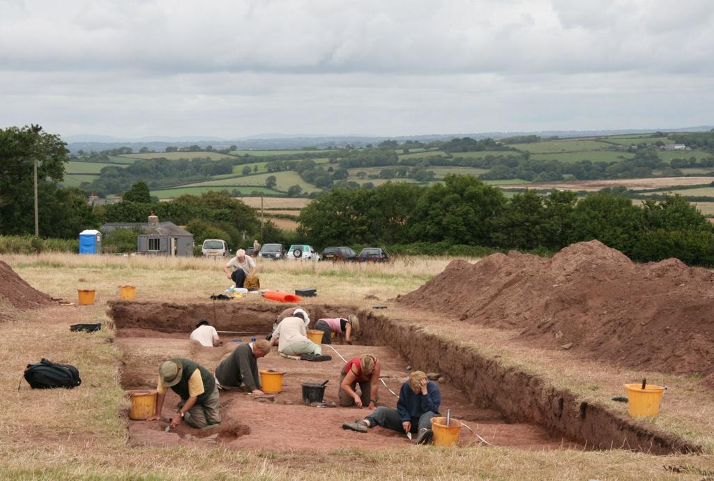
9 EXCAVATION RESULTS The locations of all cut trenches are represented in Figure 1. Trench 1 (Figs 1 and 2) Trench 1 (measuring 20m long, and 4.50m wide) was located so as to characterize a variety of features identified from the geophysical survey. These included a series of ditches apparently enclosing the chapel. A number of possible pits and post holes were identified within the enclosed area, but on excavation, many of these proved unconvincing and have been interpreted as animal burrows or root holes. The fill of one feature contained several human teeth, probably representing a neonate burial. Some post holes were cut into the backfills of the enclosure ditches. No buried soil horizon was identified. Linear feature 106 This is the latest feature within the excavated area. It appeared to terminate at the southern end of the trench, and probably continued northwards beyond the end of the trench. The feature cut all ditch fills and other cut features, but in places it was hard to define. The apparent irregularity of its base suggests it was not structural or designed to carry running water. It is therefore thought to be a shallow field or property boundary. Sub-circular ditch cuts 116 and 117 From the evidence of the geophysical survey, these two ditches appear to follow the same alignment and are therefore assumed to be associated with each other. From the excavated evidence, however, it is unclear whether they were both open at the same time. The ditches have different profiles. There is also no surviving in-situ evidence for banks associated with either ditch. Several pieces of shale which exhibited possible evidence of pick marks were, however, recovered from some of the ditch fills. These may be derived from former bank material. The ditch fills also show evidence of having been re-cut. Several post-holes were located between the ditches, where banks are likely to have been located when either or both ditches were functional. It is not clear whether the post holes pre-date or post-date the ditches (and banks). Discussion Even with associated banks, neither ditch is sufficiently wide or deep to present an impregnable barrier. There is no evidence for palisade or revetment posts associated with either ditch. Porthclew Chapel appears to be located well within the area enclosed by these ditches, but there is as yet no evidence to prove that the chapel and enclosures are necessarily contemporary with each other. It has been suggested that the geophysics survey may indicate an opening in the eastern side of this enclosure. Rectangular? ditch cut 118 The geophysical survey suggests that this feature is a rectilinear cut with curved corners. The excavated evidence, also suggests this ditch is on a different alignment to the outer ditches, perhaps suggesting they are not contemporary with each other. Within the excavated area however, there was no stratigraphic evidence to demonstrate whether ditch 118 was earlier or later than ditch 117. The ditch is relatively wide in relation to its shallow depth and would not have had a defensive function. Within the excavated area, any bank on the inside edge of this ditch would have been removed by the cutting of features 139.
10 Discussion It is not entirely clear from the geophysics whether ditch 118 forms a rectangular enclosure containing the chapel on its eastern edge, or if the chapel is built on top of the ditch. Ditch cut? 139 On the geophysical survey this feature appears to be a ditch running along the inside edge of the enclosure formed by ditch 118 (parallel to its north side). The excavation revealed a shallow, broad, flat-bottomed ditch that appeared to cut the southern edge of ditch 118. The southern edge of 139 was itself cut by intercutting pit group Discussion It is uncertain what this group of features represents. There was no evidence of post-pipes in the fills of pits , perhaps suggesting they were not postholes, though this remains the most likely explanation. They appear to respect the boundary formed by ditch 118, and may be associated with it. They may represent a series of 'rubbish' pits cut along the edge of the enclosed area, or perhaps an unfinished ditch constructed by cutting a series of small intercutting pits. Layer 104 appears to be a backfill deposit within a linear hollow formed by the combined cuts of features 118 and Its fill had a relatively high charcoal content. Wall 146 Wall 146 was built on top of fill 104, and appears to represent a phase of activity that is later than all the enclosure ditches. It is not clear what structure 146 represents, but it may be associated with a possible phase of settlement structures tentatively suggested on the geophysical survey. There are several rectangular features to the north and northeast of the chapel that may represent buildings. Some of these features appear to be built over the backfilled enclosure ditches. A wind-blown sand deposit had accumulated against the north side of wall 146. Discussion If wall 146 represents a phase of occupation or settlement, it would appear to be late in the sequence of events at the site, after at least some of the boundary ditches were backfilled and any associated banks had been leveled. Until dating evidence for the underlying ditches is fully analysed and more is understood about this phase, it remains unknown how any settlement on the site relates to the chapel and cemetery. Wall 146 is similar in character to wall 204 in Trench 2. Both features may belong to the same phase. Trench 2 Trench 2 was one of four trenches located to ascertain the extent of burials in the field to the south of the chapel. The trench contained the well-constructed cist burial of a child (SK003). Other burials in this trench were not excavated, but no evidence of cist structures was apparent. To the south of SK003, ditch 207 is assumed to be a return or continuation of one of the ditches revealed in Trench 1, although which one remains uncertain. On the northern (inside) edge of the ditch was a stone wall base 204, similar in character to wall 146 in Trench could be a remnant of a stone-faced bank. Although these walls may belong to the same phase, it is interesting that while wall 204 is probably contemporary with ditch 207, in Trench 1 there is no surviving evidence of walls associated with the ditches, or a ditch associated with wall 146.
11 It is also interesting that there are burials on both sides of ditch 207, suggesting either that it pre-dates the cemetery, or that the cemetery expanded beyond its original boundary. Trench 3 Trench 3 also contained burials. Two inter-cutting burials were excavated (SK 002 and SK 004), the earlier of which was contained in a cist structure. Evidence of other burials within the trench was noted. Trench 4 Trench 4 was different from the other trenches in that it contained thick deposits of wind-blown sand. These would appear to have accumulated within or against what appears to be a linear feature on the geophysics survey. The character of this feature was not, however ascertained, but it seems likely to be a constructed feature. Cist burials and plain burials were also present, cut into the wind blown sand deposit. One burial (SK001) was excavated, SK006 (of which only the head and shoulders were revealed) and left in situ. Trench 5 Trench 5 contained concentrations of non-articulated human bone. No evidence of surviving in situ burials or burial cuts was identified. The bone may therefore be remnants of ploughed out burials or material that has been transported from elsewhere in the field through plough action. Trench 6 Trench 6 was located to provide a section across the north wall of the chapel to investigate construction methods and the degree of survival of the chapel below ground. On the inside of the chapel the excavation revealed that the floor surface has been removed. A single post-hole next to the wall face may relate to the construction of the chapel. Outside, evidence of an episode of repair or renovation of the chapel was suggested by a mortar spread. There was also evidence of a foundation cut for the chapel wall and a rough rubble surface beneath which was located a cist burial (SK005) on a different alignment to the chapel walls.
12 FINDS AND SPECIALIST ANALYSES Worked stone, pottery, metal artefacts, animal bone, monolith samples (for possible pollen analysis), mollusc samples and geomorphology samples (for possible thin section analysis) recovered from the excavation are currently in storage awaiting future conservation, processing and analysis. The following analyses are currently under way: AMS Dating With contingency funding from Cadw, the following carbon samples have been sent for AMS dating: SAMPLE Fill Cut Trench The AMS dates have recently been received and are included as Appendix 1. The possible implications of the dating evidence are outlined in the conclusions section. Skeletal analysis The excavated skeletal material is currently undergoing isotopic analysis and assessment of age, sex and basic pathology. Burial Fill Cut Trench SK SK SK SK SK Bulk flotation samples Bulk flotation samples from the main enclosure ditches and selected pit and posthole fills are currently being processed.
13 CONCLUSIONS Archaeology The excavations at Porth Clew have provided important information on the nature and character of the early medieval cemetery and confirmed the existence of significant archaeological features across most of the survey area. Although the results from the excavations are necessarily limited, a considerable amount of information has been recovered, This has perhaps resulted in more questions being raised, than have been answered. Some aspects of the chronology of the features is clarified by 6 AMS C14 dates obtained from the lower fills of the ditch features in Trenches 1 and 2. A preliminary interpretation of the dates indicates that all of the features appear to date to the early medieval period, spanning a range from AD550 to AD 1010 at 2 sigma calibration. These dates suggest that the rectilinear enclosure ditch (118) and the intercutting pit group ( ) are contemporary and are the earliest features. Of the two curvilinear enclosure ditches, the inner one (117) is possibly earlier than the outer one (116). This evidence may suggest that the enclosed area was systematically enlarged over time. The dates, stratigraphy and ceramics may also suggest that the possible evidence for occupation (represented by wall 146) postdates both enclosures 118 and 117. The chapel is clearly later than the rectilinear enclosure, and possibly the outer enclosures too. The dating evidence obtained so far, raises several questions about what kind of site the enclosures at Porthclew represents, its longevity and how it may have changed and developed. It will be particularly interesting to obtain dating evidence from the recovered burials, small finds and ceramics, to ascertain at what time the cemetery was established in relation to the chapel, enclosures and settlement. Clearly, the site is proving to be unique in terms of excavated early medieval sites in Pembrokeshire. It is providing new and significant information which has the potential to greatly increase our understanding of the early medieval period in a variety of ways, both within the region and further afield. Monument management From a monument management perspective, the excavation has demonstrated that significant archaeological features important to understanding the context of the site exist beyond the immediate vicinity of the chapel itself. Better understanding of the character of the buried features has clarified the likely implications of potential future threats. It was not, however, possible to evaluate the character and extent of all the archaeology within the study area, or whether archaeological significant features extend beyond the study area. Since 2005, these fields have been subject to a management agreement between PCNPA and the landowners who are sympathetic to and enthusiastic about the conservation and protection of the site. However, the masonry of the chapel will continue to deteriorate if not conserved in the immediate future. Statutory protection will encourage and enable this to be achieved. In addition, although the land is currently sympathetically managed, until the full character, complexity, importance and especially the extent of the site both within and beyond the current study area is ascertained, this management may not
14 encompass the full extent of the significant buried archaeology. While the site remains unprotected, the potential for future damage to the important belowground, cropmark and earthwork aspects of the site remains from a variety of potential threats such as metal detecting, inadvertent conflicts between archaeological and agricultural or habitat management goals, and from housing or infrastructure development. Any original earthwork features surrounding the chapel have been ploughed flat by previous agricultural activity. Cut features and grave structures survive immediately below the plough zone, which varies in depth across the site. Bone preservation on the site is generally fairly good, due to the sandy soil conditions. However, some graves lie close to the present ground surface, and grave structures would be vulnerable to ploughing or other disturbance (as has occurred previously). In addition, the geophysical survey has identified areas of possible settlement. While some evidence of stone-built walls was revealed by the excavations (late in the stratigraphic sequence), the period, extent, character and degree of survival of these features remains unknown, as does their vulnerability. Outreach The project was very successful from the point of view of student training, handson public involvement and public outreach generally. Archaeology students from Lampeter and Bristol universities gained a variety of excavation experience, and, as well as engaging volunteers new to archaeology, participants from previous excavations at West Angle Bay and Maenclochog were also able to attend. Engagement in excavations, followed by public presentations such as the 'Pembrokeshire Day School' brings a new audience to the archaeology of the region, fostering new interest, understanding and support for the protection, management and enjoyment of cultural heritage in both locals and visitors to the area. Archaeological research The excavations have demonstrated that although not yet fully understood, the site clearly has considerable potential to clarify the local history and development of Porth Clew and Freshwater East. The site also offers an opportunity to add to an increasing body of important new information on early medieval ecclesiastical and secular sites in Pembrokeshire such as Brownslade, Angle, St Brides and St Ishmaels and Maenclochog. The site may provide a good example of how small settlements in Pembrokeshire have developed, perhaps in continuity, since the prehistoric, with early and later medieval phases of occupation and/or ritual or ecclesiastical activity represented on the same site. The well preserved skeletal remains could provide an assemblage of national importance to research into the early medieval period in Wales, for comparison with the skeletal assemblage recovered from the recent excavations at Brownslade Barrow. This archaeological potential, combined with the outreach potential make it a good candidate for a broader programme of archaeological excavation for comparison with the numerous other early medieval coastal cemetery sites around the Milford Haven waterway.
15 Future work Several aspects of the site remain to be understood. These include: How far within and beyond the present study area does the cemetery extend? Is there a prehistoric phase on the site? Is there an early medieval ecclesiastical settlement or religious site? Is there evidence of later medieval settlement at the site? How far does it extend? How do the various enclosure ditches relate to the standing chapel? How do the phases of activity on the site relate to episodes of coastal sand inundation? Over what time span has there been a cemetery at the site? Full finds analysis for metal objects and pottery Dating of human bone and analysis of diet, pathology and ethnicity.
16 SOURCES James, H, (ND) Port Clew Settlement History and Morphology. HER DRF PRN Ludlow, N, 2005a, The Pembrokeshire Cemeteries Project, unpublished Cambria Archaeology Report. Ludlow, N, 2000 The Cadw Historic Churches Project: Pembrokeshire, unpublished Cambria Archaeology report. Ludlow, N, 2002 The Cadw Early Medieval Ecclesiastical Sites Project: Pembrokeshire, unpublished report 2002/24, Cambria Archaeology Ludlow, N, 2005 The Pembrokeshire Cemeteries Project Interim Report, unpublished report 2005/138, Cambria Archaeology Lane, A. (eds.), 1992 The Early Church in Wales & West (Oxford, Oxbow Monograph 16), Schlee, D E, 2000 Emergency recording of human burials at Sea Hollies, FreshwateEast. HER DRF PRN4402.
EXCAVATION OF A BRONZE AGE ROUND BARROW (PRN 55928) AT PANT Y BUTLER, LLANGOEDMOR, CEREDIGION, 2010
 AT PANT Y BUTLER, LLANGOEDMOR, CEREDIGION, 2010") EXCAVATION OF A BRONZE AGE ROUND BARROW (PRN 55928) AT PANT Y BUTLER, LLANGOEDMOR, CEREDIGION, 2010 Prepared by Dyfed Archaeological Trust For: CADW 1 DYFED ARCHAEOLOGICAL TRUST RHIF YR ADRODDIAD / REPORT
EXCAVATION OF A BRONZE AGE ROUND BARROW (PRN 55928) AT PANT Y BUTLER, LLANGOEDMOR, CEREDIGION, 2010 Prepared by Dyfed Archaeological Trust For: CADW 1 DYFED ARCHAEOLOGICAL TRUST RHIF YR ADRODDIAD / REPORT
ST PATRICK S CHAPEL, ST DAVIDS PEMBROKESHIRE 2015
 ST PATRICK S CHAPEL, ST DAVIDS PEMBROKESHIRE 2015 REPORT FOR THE NINEVEH CHARITABLE TRUST THE UNIVERSITY OF SHEFFIELD AND DYFED ARCHAEOLOGICAL TRUST Introduction ST PATRICK S CHAPEL, ST DAVIDS, PEMBROKESHIRE,
An archaeological watching brief and recording at Brightlingsea Quarry, Moverons Lane, Brightlingsea, Essex October 2003
 An archaeological watching brief and recording at Brightlingsea Quarry, Moverons Lane, Brightlingsea, Essex commissioned by Mineral Services Ltd on behalf of Alresford Sand & Ballast Co Ltd report prepared
Former Whitbread Training Centre Site, Abbey Street, Faversham, Kent Interim Archaeological Report Phase 1 November 2009
 Former Whitbread Training Centre Site, Abbey Street, Faversham, Kent Interim Archaeological Report Phase 1 November 2009 SWAT. Archaeology Swale and Thames Archaeological Survey Company School Farm Oast,
ARCHAEOLOGICAL EVALUATION AT BRIGHTON POLYTECHNIC, NORTH FIELD SITE, VARLEY HALLS, COLDEAN LANE, BRIGHTON. by Ian Greig MA AIFA.
 ARCHAEOLOGICAL EVALUATION AT BRIGHTON POLYTECHNIC, NORTH FIELD SITE, VARLEY HALLS, COLDEAN LANE, BRIGHTON by Ian Greig MA AIFA May 1992 South Eastern Archaeological Services Field Archaeology Unit White
An archaeological evaluation at 16 Seaview Road, Brightlingsea, Essex February 2004
 An archaeological evaluation at 16 Seaview Road, Brightlingsea, Essex February 2004 report prepared by Kate Orr on behalf of Highfield Homes NGR: TM 086 174 (c) CAT project ref.: 04/2b ECC HAMP group site
FAN FOEL ROUND BARROW, MYNYDD DU
 FAN FOEL ROUND BARROW, MYNYDD DU AN ARCHAEOLOGICAL EXCAVATION, JUNE 2004 Interim report Paratowyd gan Archaeoleg Cambria Ar gyfer Cadw a Parc Cenedlaethol Bannau Brycheiniog Prepared by Cambria Archaeology
New Composting Centre, Ashgrove Farm, Ardley, Oxfordshire
 New Composting Centre, Ashgrove Farm, Ardley, Oxfordshire An Archaeological Watching Brief For Agrivert Limited by Andrew Weale Thames Valley Archaeological Services Ltd Site Code AFA 09/20 August 2009
Monitoring Report No. 99
 Monitoring Report No. 99 Enniskillen Castle Co. Fermanagh AE/06/23 Cormac McSparron Site Specific Information Site Name: Townland: Enniskillen Castle Enniskillen SMR No: FER 211:039 Grid Ref: County: Excavation
Archaeological. Monitoring & Recording Report. Fulbourn Primary School, Cambridgeshire. Archaeological Monitoring & Recording Report.
 Fulbourn Primary School, Cambridgeshire Archaeological Monitoring & Recording Report October 2014 Client: Cambridgeshire County Council OA East Report No: 1689 OASIS No: oxfordar3-192890 NGR: TL 5190 5613
Greater London GREATER LONDON 3/606 (E ) TQ
 TQ") GREATER LONDON City of London 3/606 (E.01.6024) TQ 30358150 1 PLOUGH PLACE, CITY OF LONDON An Archaeological Watching Brief at 1 Plough Place, City of London, London EC4 Butler, J London : Pre-Construct
GREATER LONDON City of London 3/606 (E.01.6024) TQ 30358150 1 PLOUGH PLACE, CITY OF LONDON An Archaeological Watching Brief at 1 Plough Place, City of London, London EC4 Butler, J London : Pre-Construct
Barnet Battlefield Survey
 In terim report on the progress of the Barnet Battlefield Survey December 2016 The Barnet Battlefield Survey is an archaeological investigation into the 1471 Battle of Barnet. It aims to define more accurately
Grim s Ditch, Starveall Farm, Wootton, Woodstock, Oxfordshire
 Grim s Ditch, Starveall Farm, Wootton, Woodstock, Oxfordshire An Archaeological Recording Action For Empire Homes by Steve Ford Thames Valley Archaeological Services Ltd Site Code SFW06/118 November 2006
An archaeological evaluation in the playground of Colchester Royal Grammar School, Lexden Road, Colchester, Essex
 An archaeological evaluation in the playground of Colchester Royal Grammar School, Lexden Road, Colchester, Essex February 2002 on behalf of Roff Marsh Partnership CAT project code: 02/2c Colchester Museum
Colchester Archaeological Trust Ltd. A Fieldwalking Survey at Birch, Colchester for ARC Southern Ltd
 Colchester Archaeological Trust Ltd A Fieldwalking Survey at Birch, Colchester for ARC Southern Ltd November 1997 CONTENTS page Summary... 1 Background... 1 Methods... 1 Retrieval Policy... 2 Conditions...
Church of St Peter and St Paul, Great Missenden, Buckinghamshire
 Church of St Peter and St Paul, Great Missenden, Buckinghamshire An Archaeological Watching Brief for the Parish of Great Missenden by Andrew Taylor Thames Valley Archaeological Services Ltd Site Code
An archaeological evaluation at the Lexden Wood Golf Club (Westhouse Farm), Lexden, Colchester, Essex
, Lexden, Colchester, Essex") An archaeological evaluation at the Lexden Wood Golf Club (Westhouse Farm), Lexden, Colchester, Essex January 2000 Archive report on behalf of Lexden Wood Golf Club Colchester Archaeological Trust 12 Lexden
An archaeological evaluation at the Lexden Wood Golf Club (Westhouse Farm), Lexden, Colchester, Essex January 2000 Archive report on behalf of Lexden Wood Golf Club Colchester Archaeological Trust 12 Lexden
LAND AT LLANEGWAD, CARMARTHENSHIRE: ARCHAEOLOGICAL EXCAVATION 2007
 LAND AT LLANEGWAD, CARMARTHENSHIRE: ARCHAEOLOGICAL EXCAVATION 2007 Prepared by Dyfed Archaeological Trust For: Davies Richards DYFED ARCHAEOLOGICAL TRUST RHIF YR ADRODDIAD / REPORT NO. 2008/70 RHIF Y PROSIECT
The Llandeilo Roman Forts: Archaeological Investigations
 The Llandeilo Roman Forts: Archaeological Investigations 2003-2007 Paratowyd gan Archaeoleg Cambria Ar gyfer Yr Ymddiriedolaeth Genedlaethol Prepared by Cambria Archaeology For the National Trust ARCHAEOLEG
3. The new face of Bronze Age pottery Jacinta Kiely and Bruce Sutton
 3. The new face of Bronze Age pottery Jacinta Kiely and Bruce Sutton Illus. 1 Location map of Early Bronze Age site at Mitchelstown, Co. Cork (based on the Ordnance Survey Ireland map) A previously unknown
Fort Arbeia and the Roman Empire in Britain 2012 FIELD REPORT
 Fort Arbeia and the Roman Empire in Britain 2012 FIELD REPORT Background Information Lead PI: Paul Bidwell Report completed by: Paul Bidwell Period Covered by this report: 17 June to 25 August 2012 Date
An archaeological evaluation at the Blackwater Hotel, Church Road, West Mersea, Colchester, Essex March 2003
 An archaeological evaluation at the Blackwater Hotel, Church Road, West Mersea, Colchester, Essex report prepared by Laura Pooley on behalf of Dolphin Developments (U.K) Ltd NGR: TM 0082 1259 CAT project
THE PRE-CONQUEST COFFINS FROM SWINEGATE AND 18 BACK SWINEGATE
 THE PRE-CONQUEST COFFINS FROM 12 18 SWINEGATE AND 18 BACK SWINEGATE An Insight Report By J.M. McComish York Archaeological Trust for Excavation and Research (2015) Contents 1. INTRODUCTION... 3 2. THE
2 Saxon Way, Old Windsor, Berkshire
 2 Saxon Way, Old Windsor, Berkshire An Archaeological Watching Brief For Mrs J. McGillicuddy by Pamela Jenkins Thames Valley Archaeological Services Ltd Site Code SWO 05/67 August 2005 Summary Site name:
MEDIEVAL AND POST-MEDIEVAL CROSSES
 MEDIEVAL AND POST-MEDIEVAL CROSSES A THREAT-RELATED ASSESSMENT 2010-11 Prepared by Dyfed Archaeological Trust For Cadw DYFED ARCHAEOLOGICAL TRUST RHIF YR ADRODDIAD / REPORT NO. 2011/1 RHIF Y PROSIECT
FURTHER MIDDLE SAXON EVIDENCE AT COOK STREET, SOUTHAMPTON (SOU 567)
") Roc. Hampshire Field Club Archaeol. Soc 52,1997, 77-87 (Hampshire Studies 1997) FURTHER MIDDLE SAXON EVIDENCE AT COOK STREET, SOUTHAMPTON (SOU 567) By M F GARNER andj VINCENT with a contribution byjacqueline
Roc. Hampshire Field Club Archaeol. Soc 52,1997, 77-87 (Hampshire Studies 1997) FURTHER MIDDLE SAXON EVIDENCE AT COOK STREET, SOUTHAMPTON (SOU 567) By M F GARNER andj VINCENT with a contribution byjacqueline
Cambridge Archaeology Field Group. Fieldwalking on the Childerley Estate Cambridgeshire
 Cambridge Archaeology Field Group Fieldwalking on the Childerley Estate Cambridgeshire 2009 to 2014 Summary Fieldwalking on the Childerley estate of Martin Jenkins and Family has revealed, up to March
Moray Archaeology For All Project
 School children learning how to identify finds. (Above) A flint tool found at Clarkly Hill. Copyright: Leanne Demay Moray Archaeology For All Project ational Museums Scotland have been excavating in Moray
7. Prehistoric features and an early medieval enclosure at Coonagh West, Co. Limerick Kate Taylor
 7. Prehistoric features and an early medieval enclosure at Coonagh West, Co. Limerick Kate Taylor Illus. 1 Location of the site in Coonagh West, Co. Limerick (based on the Ordnance Survey Ireland map)
WESTSIDE CHURCH (TUQUOY)
") Property in Care (PIC) ID: PIC324 Designations: Scheduled Monument (SM90312) Taken into State care: 1933 (Guardianship) Last reviewed: 2004 HISTORIC ENVIRONMENT SCOTLAND STATEMENT OF SIGNIFICANCE WESTSIDE
Property in Care (PIC) ID: PIC324 Designations: Scheduled Monument (SM90312) Taken into State care: 1933 (Guardianship) Last reviewed: 2004 HISTORIC ENVIRONMENT SCOTLAND STATEMENT OF SIGNIFICANCE WESTSIDE
Peace Hall, Sydney Town Hall Results of Archaeological Program (Interim Report)
") Results of Archaeological Program (Interim Report) Background The proposed excavation of a services basement in the western half of the Peace Hall led to the archaeological investigation of the space in
Results of Archaeological Program (Interim Report) Background The proposed excavation of a services basement in the western half of the Peace Hall led to the archaeological investigation of the space in
This is a repository copy of Anglo-Saxon settlements and archaeological visibility in the Yorkshire Wolds.
 This is a repository copy of Anglo-Saxon settlements and archaeological visibility in the Yorkshire Wolds. White Rose Research Online URL for this paper: http://eprints.whiterose.ac.uk/1172/ Book Section:
Is this the Original Anglo-Saxon period site of Weathercote?
 Is this the Original Anglo-Saxon period site of Weathercote? A Batty & N Crack 2016 Front Cover. Looking south east across proposed original site of Weathercote. Photograph A 2 3 Weathercote Anglo-Saxon
STONES OF STENNESS HISTORIC ENVIRONMENT SCOTLAND STATEMENT OF SIGNIFICANCE
 Property in Care (PIC) ID: PIC321 Designations: Scheduled Monument (SM90285); Taken into State care: 1906 (Guardianship) Last reviewed: 2003 HISTORIC ENVIRONMENT SCOTLAND STATEMENT OF SIGNIFICANCE STONES
Archaeological sites and find spots in the parish of Burghclere - SMR no. OS Grid Ref. Site Name Classification Period
 Archaeological sites and find spots in the parish of Burghclere - SMR no. OS Grid Ref. Site Name Classification Period SU45NE 1A SU46880 59200 Ridgemoor Farm Inhumation Burial At Ridgemoor Farm, on the
Archaeological Evaluation at Alconbury Weald Enterprise Zone
 Archaeological Evaluation at Alconbury Weald Enterprise Zone Archaeological Evaluation Report June 2015 Client: CgMS OA East Report No: 1768 OASIS No: oxfordar3-212519 NGR: TL 1975 7684 Archaeological
Cambridge Archaeology Field Group. Fieldwalking on the Childerley Estate, Cambridgeshire. Autumn 2014 to Spring Third interim report
 Cambridge Archaeology Field Group Fieldwalking on the Childerley Estate, Cambridgeshire Autumn 2014 to Spring 2015 Third interim report Summary Field walking on the Childerley estate of Martin Jenkins
Chapter 2. Remains. Fig.17 Map of Krang Kor site
 Chapter 2. Remains Section 1. Overview of the Survey Area The survey began in January 2010 by exploring the site of the burial rootings based on information of the rooted burials that was brought to the
Chapter 2: Archaeological Description
 Chapter 2: Archaeological Description Phase 1 Late Neolithic, c 3000-2400 BC (Figs 6-9) Evidence of Neolithic activity was confined to pits dug across the southern half of the site (Fig. 6). Eighteen pits
TIPPERARY HISTORICAL JOURNAL 1994
 TPPERARY HSTORCAL JOURNAL 1994 County Tipperary Historical Society www.tipperarylibraries.ie/ths society@tipperarylibraries. ie SSN 0791-0655 Excavations at Cormac's Chapel, Cashel, 1992 and 1993: a preliminary
Fieldwalking at Cottam 1994 (COT94F)
") Fieldwalking at Cottam 1994 (COT94F) Tony Austin & Elizabeth Jelley (19 Jan 29) 1. Introduction During the winter of 1994 students from the Department of Archaeology at the University of York undertook
Fieldwalking at Cottam 1994 (COT94F) Tony Austin & Elizabeth Jelley (19 Jan 29) 1. Introduction During the winter of 1994 students from the Department of Archaeology at the University of York undertook
A Sense of Place Tor Enclosures
 A Sense of Place Tor Enclosures Tor enclosures were built around six thousand years ago (4000 BC) in the early part of the Neolithic period. They are large enclosures defined by stony banks sited on hilltops
SALVAGE EXCAVATIONS AT OLD DOWN FARM, EAST MEON
 Proc. Hants. Field Club Archaeol. Soc. 36, 1980, 153-160. 153 SALVAGE EXCAVATIONS AT OLD DOWN FARM, EAST MEON By RICHARD WHINNEY AND GEORGE WALKER INTRODUCTION The site was discovered by chance in December
Silwood Farm, Silwood Park, Cheapside Road, Ascot, Berkshire
 Silwood Farm, Silwood Park, Cheapside Road, Ascot, Berkshire An Archaeological Watching Brief For Imperial College London by Tim Dawson Thames Valley Archaeological Services Ltd Site Code SFA 09/10 April
Hen Gastell, Llanwnda A Medieval Defended Site
 Hen Gastell, Llanwnda A Medieval Defended Site Summary of Excavation Report Ymddiriedolaeth Archaeolegol Gwynedd Gwynedd Archaeological Trust 47 46 48 Crown Copyright and database right 2016. Ordnance
The excavation of a coastal promontory fort at Porth y Rhaw, Solva, Pembrokeshire,
 Archaeologia Cambrensis 159 (2010), 53 98 The excavation of a coastal promontory fort at Porth y Rhaw, Solva, Pembrokeshire, 1995 98 By PETE CRANE and KENNETH MURPHY 1 with contributions by A. E. Caseldine
Evidence for the use of bronze mining tools in the Bronze Age copper mines on the Great Orme, Llandudno
 Evidence for the use of bronze mining tools in the Bronze Age copper mines on the Great Orme, Llandudno Background The possible use of bronze mining tools has been widely debated since the discovery of
Cetamura Results
 Cetamura 2000 2006 Results A major project during the years 2000-2006 was the excavation to bedrock of two large and deep units located on an escarpment between Zone I and Zone II (fig. 1 and fig. 2);
Archaeological Watching Brief (Phase 2) at Court Lodge Farm, Aldington, near Ashford, Kent December 2011
 at Court Lodge Farm, Aldington, near Ashford, Kent December 2011") Archaeological Watching Brief (Phase 2) at Court Lodge Farm, Aldington, near Ashford, Kent December 2011 SWAT. Archaeology Swale and Thames Archaeological Survey Company School Farm Oast, Graveney Road
Archaeological Watching Brief (Phase 2) at Court Lodge Farm, Aldington, near Ashford, Kent December 2011 SWAT. Archaeology Swale and Thames Archaeological Survey Company School Farm Oast, Graveney Road
ARCHAEOLOGICAL EXCAVATION REPORT: THE PADDOCK, HIGH DIKE, NAVENBY, LINCOLNSHIRE
 ARCHAEOLOGICAL EXCAVATION REPORT: THE PADDOCK, HIGH DIKE, NAVENBY, LINCOLNSHIRE NGR: 499398, 357274 AAL Site Code: NAPA 13 OASIS Reference Number: allenarc1-205997 Report prepared for Navenby Archaeology
Monitoring Report No Sacred Heart Church Aghamore Boho Co. Fermanagh AE/10/116E. Brian Sloan L/2009/1262/F
 Monitoring Report No. 202 Sacred Heart Church Aghamore Boho Co. Fermanagh AE/10/116E Brian Sloan L/2009/1262/F Site Specific Information Site Address: Sacred Heart Church, Aghamore, Boho, Co. Fermanagh
A visit to the Wor Barrow 21 st November 2015
 A visit to the Wor Barrow 21 st November 2015 Following our exploration of Winkelbury a few weeks previously, we fast forwarded 12 years in Pitt Rivers remarkable series of excavations and followed him
(photograph courtesy Earle Seubert)
") THE ARCHAEOLOGY OF A CEMETERY THE TRIALS AND TRIBULATIONS OF FINDING THE LOST GRAVES OF WOODMAN POINT QUARANTINE STATION This presentation is about a project initiated by the Friends of Woodman Point and
THE ARCHAEOLOGY OF A CEMETERY THE TRIALS AND TRIBULATIONS OF FINDING THE LOST GRAVES OF WOODMAN POINT QUARANTINE STATION This presentation is about a project initiated by the Friends of Woodman Point and
Undley Hall, Lakenheath LKH 307
 ARCHAEOLOGICAL EVALUATION AND MONITORING REPORT SCCAS REPORT No. 2010/005 Undley Hall, Lakenheath LKH 307 E. Muldowney SCCAS January 2010 www.suffolkcc.gov.uk/e-and-t/archaeology Lucy Robinson, County
THE RAVENSTONE BEAKER
 DISCOVERY THE RAVENSTONE BEAKER K. J. FIELD The discovery of the Ravenstone Beaker (Plate Xa Fig. 1) was made by members of the Wolverton and District Archaeological Society engaged on a routine field
Greater London Region GREATER LONDON 3/567 (E.01.K099) TQ BERMONDSEY STREET AND GIFCO BUILDING AND CAR PARK
 TQ BERMONDSEY STREET AND GIFCO BUILDING AND CAR PARK") GREATER LONDON 3/567 (E.01.K099) TQ 33307955 156-170 BERMONDSEY STREET AND GIFCO BUILDING AND CAR PARK Assessment of an Archaeological Excavation at 156-170 Bermondsey Street and GIFCO Building and Car
GREATER LONDON 3/567 (E.01.K099) TQ 33307955 156-170 BERMONDSEY STREET AND GIFCO BUILDING AND CAR PARK Assessment of an Archaeological Excavation at 156-170 Bermondsey Street and GIFCO Building and Car
Test-Pit 3: 31 Park Street (SK )
") -Pit 3: 31 Park Street (SK 40732 03178) -Pit 3 was excavated in a flower bed in the rear garden of 31 Park Street, on the northern side of the street and west of an alleyway leading to St Peter s Church,
-Pit 3: 31 Park Street (SK 40732 03178) -Pit 3 was excavated in a flower bed in the rear garden of 31 Park Street, on the northern side of the street and west of an alleyway leading to St Peter s Church,
STONE implements and pottery indicative of Late Neolithic settlement are known to
 Late Neolithic Site in the Extreme Northwest of the New Territories, Hong Kong Received 29 July 1966 T. N. CHIU* AND M. K. WOO** THE SITE STONE implements and pottery indicative of Late Neolithic settlement
Erection of wind turbine, Mains of Loanhead, Old Rayne, AB52 6SX
 Erection of wind turbine, Mains of Loanhead, Old Rayne, AB52 6SX Ltd 23 November 2011 Erection of wind turbine, Mains of Loanhead, Old Rayne, AB52 6SX CONTENTS 1 INTRODUCTION 3 2 ARCHAEOLOGICAL BACKGROUND
39, Walnut Tree Lane, Sudbury (SUY 073) Planning Application No. B/04/02019/FUL Archaeological Monitoring Report No. 2005/112 OASIS ID no.
 Planning Application No. B/04/02019/FUL Archaeological Monitoring Report No. 2005/112 OASIS ID no.") 39, Walnut Tree Lane, Sudbury (SUY 073) Planning Application No. B/04/02019/FUL Archaeological Monitoring Report No. 2005/112 OASIS ID no. 9273 Summary Sudbury, 39, Walnut Tree Lane, Sudbury (TL/869412;
39, Walnut Tree Lane, Sudbury (SUY 073) Planning Application No. B/04/02019/FUL Archaeological Monitoring Report No. 2005/112 OASIS ID no. 9273 Summary Sudbury, 39, Walnut Tree Lane, Sudbury (TL/869412;
December 6, Paul Racher (P007) Archaeological Research Associates Ltd. 900 Guelph St. Kitchener ON N2H 5Z6
 Archaeological Research Associates Ltd. 900 Guelph St. Kitchener ON N2H 5Z6") Ministry of Tourism, Culture and Sport Culture Programs Unit Programs and Services Branch Culture Division 401 Bay Street, Suite 1700 Toronto ON M7A 0A7 Tel.: 416-314-2120 Ministère du Tourisme, de la
Ministry of Tourism, Culture and Sport Culture Programs Unit Programs and Services Branch Culture Division 401 Bay Street, Suite 1700 Toronto ON M7A 0A7 Tel.: 416-314-2120 Ministère du Tourisme, de la
BALNUARAN. of C LAVA. a prehistoric cemetery. A Visitors Guide to
 A Visitors Guide to BALNUARAN of C LAVA a prehistoric cemetery Milton of Clava Chapel (?) Cairn River Nairn Balnuaran of Clava is the site of an exceptionally wellpreserved group of prehistoric burial
Lanton Lithic Assessment
 Lanton Lithic Assessment Dr Clive Waddington ARS Ltd The section headings in the following assessment report refer to those in the Management of Archaeological Projects (HBMC 1991), Appendix 4. 1. FACTUAL
An archaeological watching brief at Sheepen, Colchester, Essex November-December 2003
 An archaeological watching brief at Sheepen, Colchester, Essex November-December 2003 report prepared by Ben Holloway on behalf of Colchester Borough Council CAT project ref.: 03/11c Colchester Museums
Chapel House Wood Landscape Project. Interim Report 2013
 Chapel House Wood Landscape Project Interim Report 2013 Chapel House Wood Landscape Project Interim Report 2013 The annual Dales Heritage Field School was held at Chapel House Wood again this year, and
1 The East Oxford Archaeology and History Project
 1 The East Oxford Archaeology and History Project EXOP TEST PIT 72 Location: Bartlemas Chapel, Cowley Date of excavation: 6-8 November 2013. Area of excavation: 0.8m x 1.2m, at the eastern end of the chapel.
LAND WEST OF ELM GROVE, EBRINGTON, GLOUCESTERSHIRE. NGR: SP (centred) ARCHAEOLOGICAL EVALUATION
 ARCHAEOLOGICAL EVALUATION") LAND WEST OF ELM GROVE, EBRINGTON, GLOUCESTERSHIRE. NGR: SP 1892 4012 (centred) ARCHAEOLOGICAL EVALUATION Report No. 640 May 2009 1q LAND WEST OF ELM GROVE, EBRINGTON, GLOUCESTERSHIRE. NGR: SP 1892 4012
LAND WEST OF ELM GROVE, EBRINGTON, GLOUCESTERSHIRE. NGR: SP 1892 4012 (centred) ARCHAEOLOGICAL EVALUATION Report No. 640 May 2009 1q LAND WEST OF ELM GROVE, EBRINGTON, GLOUCESTERSHIRE. NGR: SP 1892 4012
NOTE A THIRD CENTURY ROMAN BURIAL FROM MANOR FARM, HURSTBOURNE PRIORS. by. David Allen with contributions by Sue Anderson and Brenda Dickinson
 Proc. Hampsh. Field Club Archaeol. Soc. 47, 1991, 253-257 NOTE A THIRD CENTURY ROMAN BURIAL FROM MANOR FARM, HURSTBOURNE PRIORS Abstract by. David Allen with contributions by Sue Anderson and Brenda Dickinson
The Living and the Dead
 The Living and the Dead Round Barrows and cairns The transition from the late Neolithic to the early Bronze Age is traditionally associated with an influx of immigrants to the British Isles from continental
An archaeological evaluation by trial-trenching at Playgolf, Bakers Lane, Westhouse Farm, Colchester, Essex
 An archaeological evaluation by trial-trenching at Playgolf, Bakers Lane, Westhouse Farm, Colchester, Essex commissioned by Mr Stephen Belchem on behalf of ADP Ltd. report prepared by Chris Lister Planning
Human remains from Estark, Iran, 2017
 Bioarchaeology of the Near East, 11:84 89 (2017) Short fieldwork report Human remains from Estark, Iran, 2017 Arkadiusz Sołtysiak *1, Javad Hosseinzadeh 2, Mohsen Javeri 2, Agata Bebel 1 1 Department of
Archaeological evaluation at the Onley Arms, The Street, Stisted, Essex
 Archaeological evaluation at the Onley Arms, The Street, Stisted, Essex November 2014 report by Pip Parmenter and Adam Wightman with a contribution from Stephen Benfield and illustrations by Emma Holloway
Changing People Changing Landscapes: excavations at The Carrick, Midross, Loch Lomond Gavin MacGregor, University of Glasgow
 Changing People Changing Landscapes: excavations at The Carrick, Midross, Loch Lomond Gavin MacGregor, University of Glasgow Located approximately 40 kilometres to the south-west of Oban, as the crow flies
Excavation Report. Medieval Occupation at Challis Green Barrington Cambridgeshire. Excavation Report. Client: Hills Partnership Limited.
 Medieval Occupation at Challis Green Barrington Cambridgeshire Excavation Report Excavation Report April 2012 Client: Hills Partnership Limited OA East Report No: 1269 OASIS No: oxfordar3-102493 NGR: TL
The Papar Project Hebrides
 The Papar Project Hebrides Barbara E. Crawford and Ian Simpson H1. Pabay/Pabaigh (Uig, Lewis) Parish History H2. Pabbay/Pabaigh (Harris) Ecclesiastical Monuments Other Archaeological Sites Fieldwork 2005
Forteviot, Palisaded Enclosure Excavations Data Structure Report. By Aoife Gould
 Forteviot, Palisaded Enclosure Excavations 2010 Data Structure Report By Aoife Gould Table of Contents Summary 2 Introduction 2 Location 2 Archaeological Background 4 Aims 4 Methodology 5 Results 8 Subsoil
Rådhuspladsen, KBM 3827
 KØBENHAVNS MUSEUM / MUSEUM OF COPENHAGEN Rådhuspladsen, KBM 3827 Cultural Historical Report, Metro Cityring Excavation Ed Lyne and Hanna Dahlström Foreword As a result of the extensive archaeological
Bronze Age 2, BC
 Bronze Age 2,000-600 BC There may be continuity with the Neolithic period in the Early Bronze Age, with the harbour being used for seasonal grazing, and perhaps butchering and hide preparation. In the
Burrell Orchard 2014: Cleveland Archaeological Society Internship Amanda Ponomarenko The Ohio State University June - August 2014
 1 Burrell Orchard 2014: Cleveland Archaeological Society Internship Amanda Ponomarenko The Ohio State University June - August 2014 Selected for the 2014 Cleveland Archaeological Society Internship in
Phase 2 Urban consolidation AD
 Phase 2 Urban consolidation AD 1250-1350 The second recognised phase of activity at Rådhuspladsen corresponded approximately to the High medieval period (c. AD 1250 1350), and saw consolidation of the
Moated Site at Manor Farm, Islip, Oxfordshire
 Moated Site at Manor Farm, Islip, Oxfordshire An Archaeological Excavation By Jo Pine Site Code MFI05 December 2007 Summary Site name: Moated Site at Manor Farm, Islip, Oxfordshire Grid reference: SP 5298
ARCHAEOLOGICAL MONITORING REPORT
 ARCHAEOLOGICAL MONITORING REPORT SCCAS REPORT No. 2009/324 Thorington Hall, Stoke by Nayland SBN 087 HER Information Date of Fieldwork: November 2009 - January 2010 Grid Reference: TM 0131 3546 Funding
E x cav atio n R e p o r t
 Medieval Trackway on land at Ivy Farm Royston, Hertfordshire Excavation Report E x cav atio n R e p o r t October 2011 Client: CgMs Consulting OA East Report No: 1305 OASIS No: oxfordar3-112012 NGR: TL
Suburban life in Roman Durnovaria
 Suburban life in Roman Durnovaria Additional specialist report Finds Ceramic building material By Kayt Brown Ceramic building material (CBM) Kayt Brown A total of 16420 fragments (926743g) of Roman ceramic
Oil lamps (inc early Christian, top left) Sofia museum
 Sofia museum") Using the travel award to attend a field school in Bulgaria was a valuable experience. Although there were some issues with site permissions which prevented us from excavating, I learned much about archaeological
Using the travel award to attend a field school in Bulgaria was a valuable experience. Although there were some issues with site permissions which prevented us from excavating, I learned much about archaeological
Bronze-Age and Romano-British Sites South-East of Tewkesbury: evaluations and excavations
 From the Transactions of the Bristol and Gloucestershire Archaeological Society Bronze-Age and Romano-British Sites South-East of Tewkesbury: evaluations and excavations 1991-7 by G. Walker, A. Thomas
An archaeological watching brief at St Leonard s church, Hythe Hill, Colchester, Essex
 An archaeological watching brief at St Leonard s church, Hythe Hill, Colchester, Essex report prepared by Adam Wightman on behalf of Dorvell Construction CAT project ref.: 10/5d Colchester and Ipswich
Bangor University. The Meillionydd Project: Characterising the double ringwork enclosures in Gwynedd Preliminary Excavation Report
 Bangor University The Meillionydd Project: Characterising the double ringwork enclosures in Gwynedd Preliminary Excavation Report Kate Waddington and Raimund Karl Bangor, August 2010 Contents Acknowledements
Essex Historic Environment Record/ Essex Archaeology and History
 Essex Historic Environment Record/ Essex Archaeology and History CAT Report 578 Summary sheet Address: Kingswode Hoe School, Sussex Road, Colchester, Essex Parish: Colchester NGR: TL 9835 2528 Type of
ARCHAEOLOGICAL S E R V I C E S. St Nicholas' Church, Barrack Hill, Nether Winchendon, Buckinghamshire. Archaeological Watching Brief.
 T H A M E S V A L L E Y ARCHAEOLOGICAL S E R V I C E S St Nicholas' Church, Barrack Hill, Nether Winchendon, Buckinghamshire Archaeological Watching Brief by Steven Crabb Site Code: STW17/229 (SP 7735
The Jawan Chamber Tomb Adapted from a report by F.S. Vidal, Dammam, December 1953
 Figure 1 - The Jawan tomb as photographed from helicopter by Sgt. W. Seto, USAF, in May 1952 The Jawan Chamber Tomb Adapted from a report by F.S. Vidal, Dammam, December 1953 I. Description of work and
Grange Farm, Widmer End, Hughenden, Buckinghamshire
 Grange Farm, Widmer End, Hughenden, Buckinghamshire An Archaeological Evaluation for British Flora by Andy Taylor Thames Valley Archaeological Services Ltd Site Code GFH 05/63 July 2005 Summary Site name:
CHAPTER 14. Conclusions. Nicky Milner, Barry Taylor and Chantal Conneller
 PA RT 6 Conclusions In conclusion it is only fitting to emphasise that, useful though the investigations at Star Carr have been in helping to fill a gap in the prehistory of north-western Europe, much
The first men who dug into Kent s Stonehenge
 From: Paul Tritton, Hon. Press Officer Email: paul.tritton@btinternet.com. Tel: 01622 741198 The first men who dug into Kent s Stonehenge Francis James Bennett (left) and a colleague at Coldrum Longbarrow
EARL S BU, ORPHIR HISTORIC ENVIRONMENT SCOTLAND STATEMENT OF SIGNIFICANCE. Property in Care (PIC) ID: PIC291 Designations:
 ID: PIC291 Designations:") Property in Care (PIC) ID: PIC291 Designations: Scheduled Monument (SM13379) Taken into State care: 1947 (Ownership) Last reviewed: 2004 HISTORIC ENVIRONMENT SCOTLAND STATEMENT OF SIGNIFICANCE EARL S BU,
Property in Care (PIC) ID: PIC291 Designations: Scheduled Monument (SM13379) Taken into State care: 1947 (Ownership) Last reviewed: 2004 HISTORIC ENVIRONMENT SCOTLAND STATEMENT OF SIGNIFICANCE EARL S BU,
Amarna South Tombs Cemetery The 2011 Excavations at the Lower Site and Wadi Mouth Site Preliminary Archaeological Report
 Amarna South Tombs Cemetery The 2011 Excavations at the Lower Site and Wadi Mouth Site Preliminary Archaeological Report A. Stevens July 2012 1 The 2011 season of excavations at the South Tombs Cemetery
SUMMARY REPORT OF 2009 INVESTIGATIONS AT OLD TOWN, LANCASTER COUNTY, SOUTH CAROLINA
 SUMMARY REPORT OF 2009 INVESTIGATIONS AT OLD TOWN, LANCASTER COUNTY, SOUTH CAROLINA by R. P. Stephen Davis, Jr. Brett H. Riggs, and David J. Cranford 2012 Between April 29 and June 12, 2009, archaeological
CUMBRIA 2/635 (C ) NY
 NY") CUMBRIA Allerdale 2/635 (C.16.6017) NY 11803070 BRIDGE STREET, COCKERMOUTH Report on an Archaeological Evaluation at Bridge Street, Cockermouth, Cumbria (Report No. 5/00) Grahame, R Carlisle : Carlisle
CUMBRIA Allerdale 2/635 (C.16.6017) NY 11803070 BRIDGE STREET, COCKERMOUTH Report on an Archaeological Evaluation at Bridge Street, Cockermouth, Cumbria (Report No. 5/00) Grahame, R Carlisle : Carlisle
St Germains, Tranent, East Lothian: the excavation of Early Bronze Age remains and Iron Age enclosed and unenclosed settlements
 Proc Soc Antiq Scot, 128 (1998), 203-254 St Germains, Tranent, East Lothian: the excavation of Early Bronze Age remains and Iron Age enclosed and unenclosed settlements Derek Alexander* & Trevor Watkinsf
EVALUATION REPORT No. 273
 EVALUATION REPORT No. 273 Freeduff Presbyterian Church, 3 Oldtown road, Freeduff, Cullyhanna, County Armagh Licence No.: AE/13/133E Sapphire Mussen Report Date: 20/09/2013 Contents List of Figures... 2