Hayling School, Church Road, Hayling Island, Hampshire
|
|
|
- Ethan Pope
- 5 years ago
- Views:
Transcription
1 Hayling School, Church Road, Hayling Island, Hampshire An Archaeological Evaluation for George Wimpey Southern Ltd by Helen Moore Thames Valley Archaeological Services Ltd Site Code HSHI 03/46 July 2003
2 Summary Site name: Hayling School, Church Road, Hayling Island Grid reference: SU 7230,0020 Site activity: Archaeological Evaluation Date and duration of project: 1st-3rd July 2003 Project manager: Helen Moore Site supervisor: Helen Moore Site code: HSHI 03/46 Area of site: c. 0.8 ha Summary of results: No archaeological features were revealed in any of the evaluation trenches, however a number of probable Neolithic and Bronze Age struck flints and flake tools were collected from the subsoil, as well as a small number of Medieval and Post- Medieval pottery sherds. Monuments identified: None Location and reference of archive: The archive is currently held at Thames Valley Archaeological Services, De Beauvoir Road, Reading, Berkshire, RG1 5NR and it is anticiapted that it will be deposited with Hampshire Museums Service in due course. This report may be copied for bona fide research or planning purposes without the explicit permission of the copyright holder Report edited/checked by: Jo Pine Steve Preston i
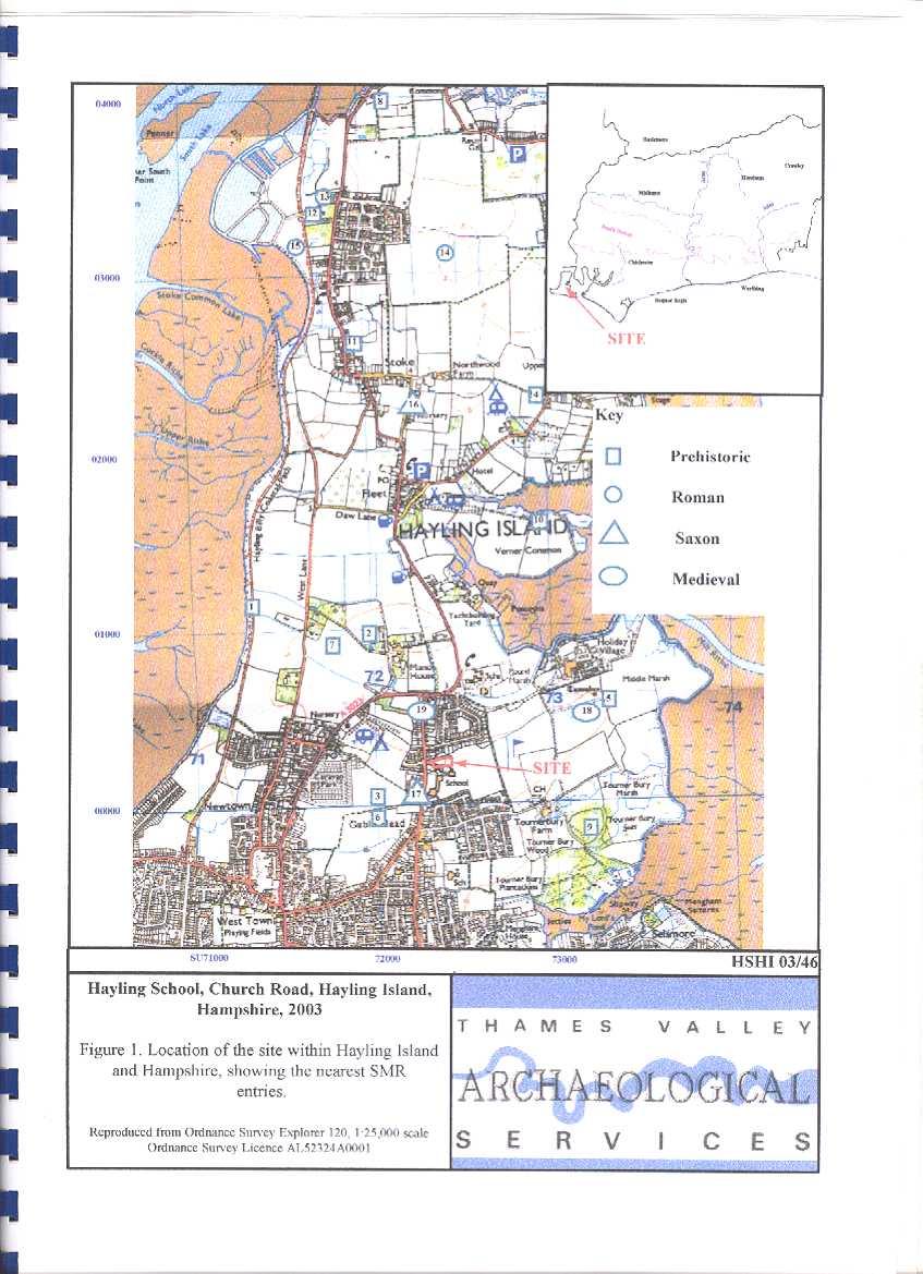
3 Hayling School, Church Road, Hayling Island, Hampshire An Archaeological Evaluation by Helen Moore Report 03/46 Introduction This report documents the results of an archaeological field evaluation carried out at Hayling School, Church Road, Hayling Island, Hampshire, PO110NU (SU ) (Fig. 1). The work was commissioned by Mr David Staniland on behalf of George Wimpey Southern Ltd, Templars House, Lulworth Close, Chandlers Ford, Eastleigh, Hampshire, SO63 3TJ. Planning permission (99/57914/006) has been granted by Havant Borough council, to redevelop the site for housing. The planning permission was subject to a condition which required an archaeological evaluation to be undertaken to assess whether archaeological deposits were present on the site. This would enable a plan to be formulated to mitigate the effects of development upon any surviving archaeology. This is in accordance with the Department of the Environment s Planning Policy Guidance, Archaeology and Planning (PPG ), and the Borough policies on archaeology. A search of the Hampshire Sites and Monuments Record was also requested by Mr Ian Wykes, Senior Archaeologist for Hampshire County Council, to establish what other known sites of archaeological interest are in the area. The field investigation was carried out to a specification approved by Mr Ian Wykes, Archaeologist for Hampshire County Council. The fieldwork was undertaken by Helen Moore and Pamela Jenkins, on the 1st, 2nd and 3rd of July 2003 and the site code is HSHI03/46. The archive is presently held at Thames Valley Archaeological Services, Reading and will be deposited with Hampshire Museum Service in due course. Location, topography and geology The site is located within the grounds of Hayling Comprehensive School on Church Road, which lies immediately to the north of South Hayling town on Hayling Island (Fig. 1). The area is quite built-up, however a golf course and woods and marshland lie immediately to the east and south of the school grounds. The site is fairly flat, and rises slightly towards the west from 6.74m to 6.95m above Ordnance Datum. The Emsworth Channel is approximately 1.25km to the east of the site. The underlying geology is London clay according to the British Geological Survey (BGS 1994). 1
4 The geology observed in the trenches was generally a mid greyish-orange sandy clay, however Trenches 9 and 10 which were the furthest east (Fig. 2) had a slightly darker and more orange-brown sandy clay. Immediately above the natural clay in most of the trenches, lay a mid greyish orange clayey sand subsoil, approximately 0.40m thick. This was a very clean and well sorted deposit, and seems to have formed over a considerable amount of time due to its thickness. All the finds recovered during the evaluation were found from this deposit, or at the interface with the natural clay. Archaeological background A search of Hampshire County Council s Sites and Monuments record revealed a number of archaeological sites and find spots in the vicinity of Hayling School, and also across the Island (Fig. 1). Many of these sites have been found during development over the past 120 years or so, and very few have been properly recorded or published. Prehistoric activity is well documented on the Island, and illustrates domestic, ritual and industrial use of the island throughout Neolithic to Iron Age periods. Few sites of Palaeolithic and Mesolithic date have been recorded, however a Palaeolithic handaxe was found on the foreshore [1], to the northwest of the site in A Mesolithic tranchet axe [2] 10 20cm long was found also to the northwest of the site in a field. A Neolithic polished axe [3] of grey flint was found in a field in 1970 immediately to the west of the site, on the other side of Church Road. It has been reworked possibly for use as a scraper. Both of these objects are now in Portsmouth City Museum. A number of Bronze Age arrowheads [6] were found in the same field. An Early Bronze Age mace head [4] with an hour glass perforation was found in 1920 at Tye Farm to the north east of the site. One of the few sites excavated on Hayling island is a Bronze Age round barrow [5] which lies to the east of the site near Tournerbury wood. It is known as Windmill Hill, and is c. 30m in diameter and 0.70m high. It has no visible ditch, and lies in field under crop overlooking Chichester harbour. It was excavated by Mr McEwen of Richmond House Hayling in The SMR records that Mr McEwen found a pebble pavement 5 10 below the surface. Lying on this surface was a layer of ashes with a hollowed tree trunk either burnt or decayed. The SMR record suggests that this may be a tree trunk coffin burial. The pebble pavement is a feature of barrows on the Isle of Wight. Other finds from the excavation include flint chippings, scrapers, imperfect arrowheads, pot sherds (some glazed) and iron nails. The barrow appears to have been used in the Medieval period [18] for a 2
5 windmill, as cruciform foundations recorded in 1919 by J. P. Williams-Freeman indicated the burnt remains of a windmill. The barrow also appears to have been excavated prior to Mr McEwans excavation, as H R Trigg in his Guide to Hayling Island in 1892 states that in 1862 a labourer digging drains had discovered a quantity of pottery under the mound described as Saxon sacrificial vessels. There is no record of where this pottery ended up. A paddock to the northwest of the site produced a Bronze Age founders hoard [7], found by Mr Walbridge, a metal detectorist. The hoard contained 131 copper alloy items including 14 separate spearhead fragments, 2 complete broad bladed palstaves, a number of ingots, 4 socketed tools comprising a chisel, and fragmentary hammers and other fragments of molten scrap. Thirty sherds of pottery from a probable Deverel-Rimbury vessel were also recovered. These sherds form part of a small bucket urn, decorated with finger impressions below the flat plain rim (Lawson, A 1999). The north coast of Hayling Island very near the modern causeway that carries the road across to the mainland has produced some interesting Bronze Age finds, including chance finds of five Late Bronze Age urned cremation burials which may be part of extensive flat cremation cemeteries. Cremations of this date have also been found on the mainland near the causeway to Hayling Island. A Bronze Age oak pile was recorded, with other timbers and an area of wattles from the north coast of Hayling Island [8]. This is thought to represent the remains of a structure, possibly a wharf (Williams, and Soffe, nd). It has been radio-carbon dated to 900BC+/ Iron Age archaeology is well represented on Hayling Island. The Iron Age hillfort of Tourner Bury [9] lies to the south east of the site. This is one of the lowest hillforts in the country being only roughly 400 metres from the shoreline, and the ground around its north and south sides marshy. It is composed of a bank and ditch enclosing a circular area of 18 ha. The site is a Scheduled Ancient Monument (no 38). The hillfort has been excavated on a number of occasions. At some point during the late 19th century, Mr Trigg excavated two trenches across the ramparts and recovered two sherds of pottery and noted the remains of fires under the earthwork (Williams-Freeman,J.P, 1915). In 1959 Mr J. R. Boyden dug a trench through the rampart and revealed at the outer edge two Norman pots. Two sherds of possible Iron Age pottery were recovered from the former land surface below the rampart. In 1968 Richard Bradley excavated two further sections through the site and produced four Iron Age vessels apparently from the surface contemporary with the rampart. 3
6 The most common features associated with Iron Age activity from Hayling Island are salterns or the remains of burnt material presumed to be associated with the process of salt making. Four possible hearths [10] were seen in section in the bank next to the waters edge opposite Verner Common associated with Iron Age pottery. A thin layer of burnt material containing pot boilers was also recorded by Richard Bradley in 1968 (information in SMR) from this area, probably representing the remains of salt producing activities. Briquetage and burnt flint pot boilers were found in two u-shaped features [11] sectioned by the digging of a sewer trench in Numerous hearths were also visible below the turf line in the trench further to the south. A site in the northern area of Hayling Island at Creek Field [12] excavated in 1966 uncovered two Iron Age salt pans or linear gullies containing briqetage, pot boilers and Iron Age pottery (Rule 1966). The majority of the known Roman remains lie to the north of the site in North Hayling. A Roman building [13] was discovered and very briefly recorded in 1908 by Mr T Ely. He describes a chamber 20 feet long by 10 feet wide with a stone pavement. Roman tiles and wall plaster are also noted. The most well documented and excavated site on Hayling Island is the Iron Age and Roman temple [14] in the north of the island. The site was first recognised as Roman in 1826, and limited excavations took place between 1897 and 1907 interpreting the site as a villa. The drought in 1976 revealed cropmarks, and the site was then excavated by Graham Soffe, Antony King and the late Robert Downey for six years uncovering the whole of an Iron Age temple and most of a Roman one. The site is unique in Britain, with a Roman circular tower or cella enclosed by double walls, and preceding this Roman phase a round wooden building within a square timber palisade, in use in the 1st century BC. Numerous finds including coins, chariot fittings, weapons and brooches were recovered from the excavations (King and Soffe 1994). A possible hut circle [15] of some 60 feet in diameter, consisting of postholes approximately 20 feet apart was discovered also in the northern part of Hayling Island. At the centre of the circle was an area of flints with a large cooking stone in the centre. No date is known for the site, and it could be anything from Bronze Age to Romano-British. Very little evidence of Saxon settlement is recorded near to the site, however the SMR records that sherds of mid Saxon pottery [16] were recovered during development to the north of the site near Stoke. A piece of Saxon sculpture [17] was recovered during excavations near the present vicarage of St Mary s in It is thought to be either a Saxon font, a lavabo or a re-used cross-base, and probably dates from the late 9th century. It is rectangular in shape and hollowed out to form a bowl inside. Three of the sides are decorated 4
7 with simple interlace patterns, and the fourth has more elaborate interlacing forming two circles, (Green, and Green, 1951). Sherds of medieval glazed pottery [18] were found during excavations of the barrow known as Windmill Hill, and to the north of the site [19]. Objectives and methodology The purpose of the evaluation was to determine the presence/absence, extent, condition, character, quality and date of any archaeological deposits within the area of development. Ten trenches were excavated in between the footprints of previously demolished buildings whose foundations still exist on the site. The northern area of the site is covered by mature trees, and as a consequence it was impossible to locate any trenches in this area. The site was also criss-crossed by drains and soakaways still in use by the school, and BT cables were also running across the northern area of the site in front of the trees. These factors meant that it was not always possible to dig a 20 metre long trench in every location, and some trenches are longer or shorter as a consequence. All the trenches were excavated using a JCB, fitted with a toothless ditching bucket, and supervised by an archaeologist at all times. Spoil heaps were monitored for finds. A complete list of trenches giving lengths, breadths, depths and a description of sections and geology is given in Appendix 1. Results (Fig.2 and 3) Trench 1 This was located on the western side of the site on the boundary with the current school house. It was aligned roughly east west and was 13.40m long. Below 0.26m of topsoil, was a pale orangey yellow clayey sand subsoil, 0.44m thick. Three broken flint flakes, and burnt flint were recovered from this deposit. The natural geology was a mid greyish-orange sandy clay. No archaeological features were present in this trench. Trench 2 This trench was aligned roughly north south along the boundary with Church Road. It was 15m long. The subsoil was the same as in trench 1 and was 0.35m thick. The subsoil produced 3 intact flakes, a broken flake, a core, a bashed lump, a spall and 2 Scrapers, as well as nine sherds of medieval and post-medieval pottery, and burnt flint. No archaeological features were observed. 5
8 Trench 3 Trench 3 was aligned NE-SW and was 15.40m long. It was disturbed by a modern pipe trench. Burnt flint and slag were recovered from the subsoil, which was 0.42m thick. No archaeological features were observed. Trench 4 Trench 4 was aligned roughly north south, and was 20.50m long. It was disturbed by a modern drain. Flint and chalk rubble made ground 0.29m thick, lay above the natural clay. No archaeological features were observed. Trench 5 Trench 5 was aligned NE-SW, and was 9.40m long. It was disturbed by a very large modern service trench. No finds were recovered from this trench, and no archaeological features were observed. Trench 6 Trench 6 was located at the southern edge of the proposed development site, and was 17.70m long. It was truncated by a modern trench for fibre optic cables. The subsoil was 0.44m thick, and contained no finds. No archaeological features were observed. Trench 7 Trench 7 (Fig. 2) was aligned roughly east west, and was excavated through a modern tarmac path. It was 20.30m long. Service trenches were cut at intervals along its length. Below the Tarmac was a flint-gravel makeup layer 0.45m thick and subsoil 0.15m thick. No finds or archaeological features were observed. Trench 8 This trench was aligned roughly north south along the western boundary with the former tennis court. It was 20.10m long. The subsoil was 0.44m thick and contained three sherds of medieval pottery and two post-medieval tiles, one broken flake, and a very small quantity of burnt flint. No archaeological features were observed. Trench 9 Trench 9 was located in the former tennis court on the eastern edge of the site, and was aligned NE-SW. It was 20.20m long. Below the Tarmac, was a makeup layer composed of flint and chalk rubble 0.29m thickness. This sealed an organic layer of rotted vegetation and roots, presumably the previous ground surface, overlying the natural clay. No finds or archaeological features were observed. Trench 10 Trench 10 was located also in the former tennis court and was aligned roughly east west. It was 19.30m long. The stratigraphy was the same as Trench 9. Burnt flint, a core and an intact flake were recovered from the top of the natural, and one sherd of post-medieval pottery. No archaeological features were observed. 6
9 Finds Struck flint by Steve Ford A modest collection of 15 struck flints were recovered from the evaluation as detailed in Appendix 2. Nine of these were recovered from Trench 2. The struck flint is not closely datable but is not obviously of Mesolithic or earlier Neolithic origin. It is is probably of later Neolithic or Bronze Age date. Pottery by Malcolm Lyne The site yielded 14 sherds of Medieval and post-medieval pottery as detailed in Appendix 3; most of which were unstratified or in the subsoil on the surface of the natural geology. Three fragments of post-medieval roof-tile were also recovered. All of the assemblages were quantified by numbers of sherds and their weights per fabric. Fabrics were classified using a x8 magnification lens with in-built metric scale for determining the natures, forms, sizes and frequencies of added inclusions and a numbered fabric series created with the prefix M for Medieval. The Medieval fabrics M.1. Oxidized orange with profuse up-to 0.30 mm. multi-coloured quartz and sparse up-to 2.00 mm angular alluvial flint and ironstone. M.2. Oxidized orange with profuse up-to 0.30 mm. multi-coloured quartz filler. M.3. Similar but fired black. M.4. Very fine sanded grey to black fabric fired buff-brown externally with splashed apple-green glaze. The Assemblages These small medieval and post-medieval pottery assemblages are almost certainly the result of field marling over a period of time from c. AD1100 to the 19th century. Slag Five pieces of iron slag were recovered from the subsoil of Trench 3, weighing 480g. Burnt Flint Forty-eight pieces of burnt flint were recovered from the subsoil or the top of the natural clay from Trenches 1, 2, 3, 8, 9 and 10. They weigh a total of 580g. 7
10 Conclusion No archaeological features were observed in any of the ten trenches. However, finds of prehistoric (late Neolithic and Bronze Age) and Medieval and Post-Medieval date were recovered from the subsoil in trenches 1,2,3, 8,9 and 10. The relatively sparse number of finds and the mixed date range of these artefacts suggests that these finds have probably worked their way into the subsoil over a great number of years through agricultural processes such as manuring, and worm action. The lack of archaeological features over the whole site suggests that these finds are the result of occupation in the surrounding area, but not however in this discrete location. Trench 2 produced the greater number of prehistoric flints, including two scrapers, but it is difficult to pinpoint whether this is significant as these are not stratified and lie within the subsoil. Archaeological find spots and sites in the near vicinity of the site have suggested prehistoric activity from the Neolithic to Iron Age, but these have been largely chance unstratified finds. The small number of Medieval pottery sherds recovered also suggests settlement in the area, but the lack of archaeological features indicate the more likely reason for their presence in the subsoil is agricultural. Overall, the results suggest that the archaeological potential of the site is negligible, however the evaluation has proved that prehistoric activities such as tool production were occurring in the vicinity, but were not necessarily focussed on this location. References BGS, 1994, British Geological Survey, 1:50000, Sheet 331, Solid and Drift Edition, Keyworth PPG16, 1990, Archaeology and Planning, Dept of the Environment Planning Policy Guidance 16, HMSO Green, A R, and Green, P M, 1951, Saxon Architecture and Sculpture in Hampshire King, A and Soffe, G, 1994, The Iron Age and Roman Temple on Hayling Island, in A Fitzpatrick and E Morris (eds) The Iron Age in Wessex:Recent Work King, A and Soffe, G, 2002, Hayling Island Current Archaeology 176 Lawson, A, 1999, Bronze Age hoards of Hampshire, in A F Harding (ed) Experiment and Design Rule, M, 1966, Prehistoric Salt Working Site at North Hayling note on Site no 30 Hampshire SMR Williams-Freeman, J P, 1915, An Introduction to Field Archaeology as Illustrated by Hampshire Williams, P and Soffe, G, nd, A Late Bronze Age Timber Structure on Hayling Island Hampshire Field Club Newsletter 8
11 APPENDIX 1: Trench details 0m at xx end Trench No. Length (m) Breadth (m) Depth (m) Comment m 1.60m 0.60m No archaeological features present. Pottery, burnt flint and struck flint recovered from the subsoil. Subsoil a pale orange-yellow clayey sand 0.18m thick. Natural geology was a mid grey-orange sandy clay. 2 15m 1.60m 0.60m-0.67m No archaeological features present. Pottery, burnt flint and flint tools and flakes recovered from the subsoil. Subsoil same as T1, but 0.35m thick. Natural geology was a mid grey-orange sandy clay m 1.60m 0.60m-0.70m No archaeological features present. Burnt Flint and slag were recovered from the subsoil. Subsoil same as T1 but 0.42m thick. Natural geology was a mid grey-orange sandy clay m 1.60m 0.55m-0.72m No archaeological features or finds present. Flint and chalk rubble 0.29m thick lay below a tarmac path 0.15m thick. Natural geology was a mid grey-orange sandy clay m 1.60m 0.70m-1.00m No archaeological features or finds present. The trench was truncated by a large modern service trench. The subsoil was a pale orangeyellow clayey sand, 0.30m thick. Natural geology was a mid greyorange sandy clay m 1.60m 0.56m-0.60m No archaeological features or finds present. The trench was truncated by a modern service trench. The subsoil was a pale orange-yellow clayey sand, 0.70m thick. Natural geology was a mid grey-orange sandy clay m 1.60m 0.43m-0.75m No archaeological features or finds present. The trench was dug through a tarmac path. Below this was a flint gravel rubble makeup layer 0.45m thick. The subsoil was a pale orange-yellow clayey sand, 0.15m thick. Natural geology was a mid grey-orange sandy clay m 1.60m 0.42m-0.50m No archaeological features were present. 1 broken flake, 3 sherds of Medieval pottery and burnt flint were recovered from the subsoil. Subsoil was a pale orange-yellow clayey sand, 0.34m thick. Natural geology was a mid grey-orange sandy clay m 1.60m 0.52m No archaeological features present. Burnt flint was recovered from the surface of the natural clay. The trench was dug through the tarmac tennis court. Below this was a chalk and flint rubble makeup layer 0.37m thick which lay above organic rotted vegetation, presumably the old ground surface. The natural geology was an orange-brown sandy clay m 1.60m 0.47m-0.52m No archaeological features present. A core, and an intact flake, burnt flint, and Post Medieval tile were recovered from the surface of the natural. The trench was dug through the tarmac tennis court. Below this was a chalk and flint rubble makeup layer 0.29m thick which lay above organic rotted vegetation, presumably the old ground surface. The natural geology was an orange-brown sandy clay. 9
12 APPENDIX 2: Worked Flint Trench Feature Fill Type 1 Subsoil - 3 Broken flakes 2 Subsoil - 3 Intact flakes; Broken flake; Core; Bashed lump; Spall; 2 Scrapers 8 Subsoil - Broken flake 10 Subsoil - Core; Intact flake 10
13 APPENDIX 3: Pottery Trench No. Context Fabric Form Date-Range No. of Sherds Weight (g) 1 Subsoil Post-Med Closed Subsoil M3 Cooking pot Subsoil M4? Subsoil Earthenware Subsoil M1 Cooking pot Saxo-Norman 1 2 abraded 2 Subsoil 0.3m from south end M2 Cooking pot Subsoil, spoil, 10-15m M2 Cooking pot Subsoil, north end M4 Jug Subsoil Tile Post-Med Top of Natural clay Post-Med
14 APPENDIX 4: Slag catalogue Iron slag Trench Weight (g) 3 480g 12
15 APPENDIX 4: Burnt Flint catalogue Trench Weight (g) 1 140g 2 130g 3 220g 8 20g 9 25g 10 50g 13
16
17
18
2 Saxon Way, Old Windsor, Berkshire
 2 Saxon Way, Old Windsor, Berkshire An Archaeological Watching Brief For Mrs J. McGillicuddy by Pamela Jenkins Thames Valley Archaeological Services Ltd Site Code SWO 05/67 August 2005 Summary Site name:
New Composting Centre, Ashgrove Farm, Ardley, Oxfordshire
 New Composting Centre, Ashgrove Farm, Ardley, Oxfordshire An Archaeological Watching Brief For Agrivert Limited by Andrew Weale Thames Valley Archaeological Services Ltd Site Code AFA 09/20 August 2009
Church of St Peter and St Paul, Great Missenden, Buckinghamshire
 Church of St Peter and St Paul, Great Missenden, Buckinghamshire An Archaeological Watching Brief for the Parish of Great Missenden by Andrew Taylor Thames Valley Archaeological Services Ltd Site Code
Silwood Farm, Silwood Park, Cheapside Road, Ascot, Berkshire
 Silwood Farm, Silwood Park, Cheapside Road, Ascot, Berkshire An Archaeological Watching Brief For Imperial College London by Tim Dawson Thames Valley Archaeological Services Ltd Site Code SFA 09/10 April
Grim s Ditch, Starveall Farm, Wootton, Woodstock, Oxfordshire
 Grim s Ditch, Starveall Farm, Wootton, Woodstock, Oxfordshire An Archaeological Recording Action For Empire Homes by Steve Ford Thames Valley Archaeological Services Ltd Site Code SFW06/118 November 2006
Grange Farm, Widmer End, Hughenden, Buckinghamshire
 Grange Farm, Widmer End, Hughenden, Buckinghamshire An Archaeological Evaluation for British Flora by Andy Taylor Thames Valley Archaeological Services Ltd Site Code GFH 05/63 July 2005 Summary Site name:
Bronze Age 2, BC
 Bronze Age 2,000-600 BC There may be continuity with the Neolithic period in the Early Bronze Age, with the harbour being used for seasonal grazing, and perhaps butchering and hide preparation. In the
ARCHAEOLOGICAL S E R V I C E S. St Nicholas' Church, Barrack Hill, Nether Winchendon, Buckinghamshire. Archaeological Watching Brief.
 T H A M E S V A L L E Y ARCHAEOLOGICAL S E R V I C E S St Nicholas' Church, Barrack Hill, Nether Winchendon, Buckinghamshire Archaeological Watching Brief by Steven Crabb Site Code: STW17/229 (SP 7735
An archaeological evaluation at 16 Seaview Road, Brightlingsea, Essex February 2004
 An archaeological evaluation at 16 Seaview Road, Brightlingsea, Essex February 2004 report prepared by Kate Orr on behalf of Highfield Homes NGR: TM 086 174 (c) CAT project ref.: 04/2b ECC HAMP group site
An archaeological evaluation in the playground of Colchester Royal Grammar School, Lexden Road, Colchester, Essex
 An archaeological evaluation in the playground of Colchester Royal Grammar School, Lexden Road, Colchester, Essex February 2002 on behalf of Roff Marsh Partnership CAT project code: 02/2c Colchester Museum
Test-Pit 3: 31 Park Street (SK )
") -Pit 3: 31 Park Street (SK 40732 03178) -Pit 3 was excavated in a flower bed in the rear garden of 31 Park Street, on the northern side of the street and west of an alleyway leading to St Peter s Church,
-Pit 3: 31 Park Street (SK 40732 03178) -Pit 3 was excavated in a flower bed in the rear garden of 31 Park Street, on the northern side of the street and west of an alleyway leading to St Peter s Church,
An archaeological evaluation at the Lexden Wood Golf Club (Westhouse Farm), Lexden, Colchester, Essex
, Lexden, Colchester, Essex") An archaeological evaluation at the Lexden Wood Golf Club (Westhouse Farm), Lexden, Colchester, Essex January 2000 Archive report on behalf of Lexden Wood Golf Club Colchester Archaeological Trust 12 Lexden
An archaeological evaluation at the Lexden Wood Golf Club (Westhouse Farm), Lexden, Colchester, Essex January 2000 Archive report on behalf of Lexden Wood Golf Club Colchester Archaeological Trust 12 Lexden
An archaeological watching brief and recording at Brightlingsea Quarry, Moverons Lane, Brightlingsea, Essex October 2003
 An archaeological watching brief and recording at Brightlingsea Quarry, Moverons Lane, Brightlingsea, Essex commissioned by Mineral Services Ltd on behalf of Alresford Sand & Ballast Co Ltd report prepared
ARCHAEOLOGICAL EVALUATION AT BRIGHTON POLYTECHNIC, NORTH FIELD SITE, VARLEY HALLS, COLDEAN LANE, BRIGHTON. by Ian Greig MA AIFA.
 ARCHAEOLOGICAL EVALUATION AT BRIGHTON POLYTECHNIC, NORTH FIELD SITE, VARLEY HALLS, COLDEAN LANE, BRIGHTON by Ian Greig MA AIFA May 1992 South Eastern Archaeological Services Field Archaeology Unit White
39, Walnut Tree Lane, Sudbury (SUY 073) Planning Application No. B/04/02019/FUL Archaeological Monitoring Report No. 2005/112 OASIS ID no.
 Planning Application No. B/04/02019/FUL Archaeological Monitoring Report No. 2005/112 OASIS ID no.") 39, Walnut Tree Lane, Sudbury (SUY 073) Planning Application No. B/04/02019/FUL Archaeological Monitoring Report No. 2005/112 OASIS ID no. 9273 Summary Sudbury, 39, Walnut Tree Lane, Sudbury (TL/869412;
39, Walnut Tree Lane, Sudbury (SUY 073) Planning Application No. B/04/02019/FUL Archaeological Monitoring Report No. 2005/112 OASIS ID no. 9273 Summary Sudbury, 39, Walnut Tree Lane, Sudbury (TL/869412;
Greater London GREATER LONDON 3/606 (E ) TQ
 TQ") GREATER LONDON City of London 3/606 (E.01.6024) TQ 30358150 1 PLOUGH PLACE, CITY OF LONDON An Archaeological Watching Brief at 1 Plough Place, City of London, London EC4 Butler, J London : Pre-Construct
GREATER LONDON City of London 3/606 (E.01.6024) TQ 30358150 1 PLOUGH PLACE, CITY OF LONDON An Archaeological Watching Brief at 1 Plough Place, City of London, London EC4 Butler, J London : Pre-Construct
S E R V I C E S. St John the Baptist Church, Penshurst, Kent. Archaeological Watching Brief. by Daniel Bray and James McNicoll-Norbury
 T H A M E S V A L L E Y ARCHAEOLOGICAL S E R V I C E S St John the Baptist Church, Penshurst, Kent Archaeological Watching Brief by Daniel Bray and James McNicoll-Norbury Site Code: JPK11/25 (TQ 5273 4385)
ARCHAEOLOGICAL MONITORING REPORT
 ARCHAEOLOGICAL MONITORING REPORT SCCAS REPORT No. 2009/324 Thorington Hall, Stoke by Nayland SBN 087 HER Information Date of Fieldwork: November 2009 - January 2010 Grid Reference: TM 0131 3546 Funding
Cambridge Archaeology Field Group. Fieldwalking on the Childerley Estate, Cambridgeshire. Autumn 2014 to Spring Third interim report
 Cambridge Archaeology Field Group Fieldwalking on the Childerley Estate, Cambridgeshire Autumn 2014 to Spring 2015 Third interim report Summary Field walking on the Childerley estate of Martin Jenkins
An archaeological evaluation by trial-trenching at Playgolf, Bakers Lane, Westhouse Farm, Colchester, Essex
 An archaeological evaluation by trial-trenching at Playgolf, Bakers Lane, Westhouse Farm, Colchester, Essex commissioned by Mr Stephen Belchem on behalf of ADP Ltd. report prepared by Chris Lister Planning
3. The new face of Bronze Age pottery Jacinta Kiely and Bruce Sutton
 3. The new face of Bronze Age pottery Jacinta Kiely and Bruce Sutton Illus. 1 Location map of Early Bronze Age site at Mitchelstown, Co. Cork (based on the Ordnance Survey Ireland map) A previously unknown
Wantage County Primary School, Garston Lane, Wantage, Oxfordshire
 Wantage County Primary School, Garston Lane, Wantage, Oxfordshire An Archaeological Evaluation for Oxfordshire County Council by Erlend Hindmarch Thames Valley Archaeological Services Ltd Site Code GLW
Colchester Archaeological Trust Ltd. A Fieldwalking Survey at Birch, Colchester for ARC Southern Ltd
 Colchester Archaeological Trust Ltd A Fieldwalking Survey at Birch, Colchester for ARC Southern Ltd November 1997 CONTENTS page Summary... 1 Background... 1 Methods... 1 Retrieval Policy... 2 Conditions...
7. Prehistoric features and an early medieval enclosure at Coonagh West, Co. Limerick Kate Taylor
 7. Prehistoric features and an early medieval enclosure at Coonagh West, Co. Limerick Kate Taylor Illus. 1 Location of the site in Coonagh West, Co. Limerick (based on the Ordnance Survey Ireland map)
Old Brewery Close and Walton Street, Aylesbury, Buckinghamshire
 Old Brewery Close and Walton Street, Aylesbury, Buckinghamshire An Archaeological Evaluation for Berkeley Homes (Oxford and Chiltern) Ltd by Sian Anthony Thames Valley Archaeological Services Ltd Site
Fieldwalking at Cottam 1994 (COT94F)
") Fieldwalking at Cottam 1994 (COT94F) Tony Austin & Elizabeth Jelley (19 Jan 29) 1. Introduction During the winter of 1994 students from the Department of Archaeology at the University of York undertook
Fieldwalking at Cottam 1994 (COT94F) Tony Austin & Elizabeth Jelley (19 Jan 29) 1. Introduction During the winter of 1994 students from the Department of Archaeology at the University of York undertook
Essex Historic Environment Record/ Essex Archaeology and History
 Essex Historic Environment Record/ Essex Archaeology and History CAT Report 578 Summary sheet Address: Kingswode Hoe School, Sussex Road, Colchester, Essex Parish: Colchester NGR: TL 9835 2528 Type of
Greater London Region GREATER LONDON 3/567 (E.01.K099) TQ BERMONDSEY STREET AND GIFCO BUILDING AND CAR PARK
 TQ BERMONDSEY STREET AND GIFCO BUILDING AND CAR PARK") GREATER LONDON 3/567 (E.01.K099) TQ 33307955 156-170 BERMONDSEY STREET AND GIFCO BUILDING AND CAR PARK Assessment of an Archaeological Excavation at 156-170 Bermondsey Street and GIFCO Building and Car
GREATER LONDON 3/567 (E.01.K099) TQ 33307955 156-170 BERMONDSEY STREET AND GIFCO BUILDING AND CAR PARK Assessment of an Archaeological Excavation at 156-170 Bermondsey Street and GIFCO Building and Car
Novington, Plumpton East Sussex
 Novington, Plumpton East Sussex The Flint Over 1000 pieces of flintwork were recovered during the survey, and are summarised in Table 0. The flint is of the same types as found in the previous survey of
Moated Site at Manor Farm, Islip, Oxfordshire
 Moated Site at Manor Farm, Islip, Oxfordshire An Archaeological Excavation By Jo Pine Site Code MFI05 December 2007 Summary Site name: Moated Site at Manor Farm, Islip, Oxfordshire Grid reference: SP 5298
Former Filling Station, High Street, Dorchester-on-Thames, Oxfordshire
 Former Filling Station, High Street, Dorchester-on-Thames, Oxfordshire An Archaeological Evaluation for Country Visions OK Limited by Sarah Coles Thames Valley Archaeological Services Ltd Site Code HSD01/36
An archaeological evaluation at the Blackwater Hotel, Church Road, West Mersea, Colchester, Essex March 2003
 An archaeological evaluation at the Blackwater Hotel, Church Road, West Mersea, Colchester, Essex report prepared by Laura Pooley on behalf of Dolphin Developments (U.K) Ltd NGR: TM 0082 1259 CAT project
Archaeological. Monitoring & Recording Report. Fulbourn Primary School, Cambridgeshire. Archaeological Monitoring & Recording Report.
 Fulbourn Primary School, Cambridgeshire Archaeological Monitoring & Recording Report October 2014 Client: Cambridgeshire County Council OA East Report No: 1689 OASIS No: oxfordar3-192890 NGR: TL 5190 5613
Former Whitbread Training Centre Site, Abbey Street, Faversham, Kent Interim Archaeological Report Phase 1 November 2009
 Former Whitbread Training Centre Site, Abbey Street, Faversham, Kent Interim Archaeological Report Phase 1 November 2009 SWAT. Archaeology Swale and Thames Archaeological Survey Company School Farm Oast,
A Fieldwalking Project At Sompting. West Sussex
 by John Funnell Introduction A Fieldwalking Project At Sompting. West Sussex During March -and April 1995 the Brighton and Hove Archaeological Society conducted fie1dwa1king in a field at Sompting West
FURTHER MIDDLE SAXON EVIDENCE AT COOK STREET, SOUTHAMPTON (SOU 567)
") Roc. Hampshire Field Club Archaeol. Soc 52,1997, 77-87 (Hampshire Studies 1997) FURTHER MIDDLE SAXON EVIDENCE AT COOK STREET, SOUTHAMPTON (SOU 567) By M F GARNER andj VINCENT with a contribution byjacqueline
Roc. Hampshire Field Club Archaeol. Soc 52,1997, 77-87 (Hampshire Studies 1997) FURTHER MIDDLE SAXON EVIDENCE AT COOK STREET, SOUTHAMPTON (SOU 567) By M F GARNER andj VINCENT with a contribution byjacqueline
Archaeological sites and find spots in the parish of Burghclere - SMR no. OS Grid Ref. Site Name Classification Period
 Archaeological sites and find spots in the parish of Burghclere - SMR no. OS Grid Ref. Site Name Classification Period SU45NE 1A SU46880 59200 Ridgemoor Farm Inhumation Burial At Ridgemoor Farm, on the
SALVAGE EXCAVATIONS AT OLD DOWN FARM, EAST MEON
 Proc. Hants. Field Club Archaeol. Soc. 36, 1980, 153-160. 153 SALVAGE EXCAVATIONS AT OLD DOWN FARM, EAST MEON By RICHARD WHINNEY AND GEORGE WALKER INTRODUCTION The site was discovered by chance in December
Archaeological evaluation at the Onley Arms, The Street, Stisted, Essex
 Archaeological evaluation at the Onley Arms, The Street, Stisted, Essex November 2014 report by Pip Parmenter and Adam Wightman with a contribution from Stephen Benfield and illustrations by Emma Holloway
An archaeological watching brief at Sheepen, Colchester, Essex November-December 2003
 An archaeological watching brief at Sheepen, Colchester, Essex November-December 2003 report prepared by Ben Holloway on behalf of Colchester Borough Council CAT project ref.: 03/11c Colchester Museums
Archaeological Watching Brief (Phase 2) at Court Lodge Farm, Aldington, near Ashford, Kent December 2011
 at Court Lodge Farm, Aldington, near Ashford, Kent December 2011") Archaeological Watching Brief (Phase 2) at Court Lodge Farm, Aldington, near Ashford, Kent December 2011 SWAT. Archaeology Swale and Thames Archaeological Survey Company School Farm Oast, Graveney Road
Archaeological Watching Brief (Phase 2) at Court Lodge Farm, Aldington, near Ashford, Kent December 2011 SWAT. Archaeology Swale and Thames Archaeological Survey Company School Farm Oast, Graveney Road
A visit to the Wor Barrow 21 st November 2015
 A visit to the Wor Barrow 21 st November 2015 Following our exploration of Winkelbury a few weeks previously, we fast forwarded 12 years in Pitt Rivers remarkable series of excavations and followed him
Lanton Lithic Assessment
 Lanton Lithic Assessment Dr Clive Waddington ARS Ltd The section headings in the following assessment report refer to those in the Management of Archaeological Projects (HBMC 1991), Appendix 4. 1. FACTUAL
Archaeological Material From Spa Ghyll Farm, Aldfield
 Archaeological Material From Spa Ghyll Farm, Aldfield Introduction Following discussions with Linda Smith the Rural Archaeologist for North Yorkshire County Council, Robert Morgan of 3D Archaeological
Archaeological trial-trenching evaluation at Chappel Farm, Little Totham, Essex. April 2013
 Archaeological trial-trenching evaluation at Chappel Farm, Little Totham, Essex April 2013 report prepared by Ben Holloway commissioned by Tim Harbord Associates on behalf of Mr Tom Howie Planning reference:
Undley Hall, Lakenheath LKH 307
 ARCHAEOLOGICAL EVALUATION AND MONITORING REPORT SCCAS REPORT No. 2010/005 Undley Hall, Lakenheath LKH 307 E. Muldowney SCCAS January 2010 www.suffolkcc.gov.uk/e-and-t/archaeology Lucy Robinson, County
A Sense of Place Tor Enclosures
 A Sense of Place Tor Enclosures Tor enclosures were built around six thousand years ago (4000 BC) in the early part of the Neolithic period. They are large enclosures defined by stony banks sited on hilltops
An archaeological watching brief at St Leonard s church, Hythe Hill, Colchester, Essex
 An archaeological watching brief at St Leonard s church, Hythe Hill, Colchester, Essex report prepared by Adam Wightman on behalf of Dorvell Construction CAT project ref.: 10/5d Colchester and Ipswich
AN EARLY MEDIEVAL RUBBISH-PIT AT CATHERINGTON, HAMPSHIRE Bj>J. S. PILE and K. J. BARTON
 AN EARLY MEDIEVAL RUBBISH-PIT AT CATHERINGTON, HAMPSHIRE Bj>J. S. PILE and K. J. BARTON INTRODUCTION THE SITE (fig. 21) is situated in the village of Catherington, one mile north-west of Horndean and 200
Monitoring Report No. 99
 Monitoring Report No. 99 Enniskillen Castle Co. Fermanagh AE/06/23 Cormac McSparron Site Specific Information Site Name: Townland: Enniskillen Castle Enniskillen SMR No: FER 211:039 Grid Ref: County: Excavation
Cambridge Archaeology Field Group. Fieldwalking on the Childerley Estate Cambridgeshire
 Cambridge Archaeology Field Group Fieldwalking on the Childerley Estate Cambridgeshire 2009 to 2014 Summary Fieldwalking on the Childerley estate of Martin Jenkins and Family has revealed, up to March
Erection of wind turbine, Mains of Loanhead, Old Rayne, AB52 6SX
 Erection of wind turbine, Mains of Loanhead, Old Rayne, AB52 6SX Ltd 23 November 2011 Erection of wind turbine, Mains of Loanhead, Old Rayne, AB52 6SX CONTENTS 1 INTRODUCTION 3 2 ARCHAEOLOGICAL BACKGROUND
Hembury Hillfort Lesson Resources. For Key Stage Two
 Hembury Hillfort Lesson Resources For Key Stage Two 1 Resource 1 Email 1 ARCHAEOLOGISTS NEEDED Dear Class, I recently moved to Payhembury and I have been having fun exploring the beautiful Blackdown Hills.
Excavation. Post-Medieval Ditches. Land off Norwich Common Road Wymondham Norfolk. Excavation. Client: November 2013
 Land off Norwich Common Road Wymondham Norfolk. Excavation November 2013 Client: OA East Report No: 1546 OASIS No: oxfordar3-163105 NGR: TG 12770 02684 Excavation Post-Medieval Ditches Post-Medieval Ditches
St Germains, Tranent, East Lothian: the excavation of Early Bronze Age remains and Iron Age enclosed and unenclosed settlements
 Proc Soc Antiq Scot, 128 (1998), 203-254 St Germains, Tranent, East Lothian: the excavation of Early Bronze Age remains and Iron Age enclosed and unenclosed settlements Derek Alexander* & Trevor Watkinsf
THE UNFOLDING ARCHAEOLOGY OF CHELTENHAM
 THE UNFOLDING ARCHAEOLOGY OF CHELTENHAM The archaeology collection of Cheltenham Art Gallery & Museum contains a rich quantity of material relating to the prehistoric and Roman occupation of the North
1 The East Oxford Archaeology and History Project
 1 The East Oxford Archaeology and History Project EXOP TEST PIT 72 Location: Bartlemas Chapel, Cowley Date of excavation: 6-8 November 2013. Area of excavation: 0.8m x 1.2m, at the eastern end of the chapel.
The lithic assemblage from Kingsdale Head (KH09)
") 1 The lithic assemblage from Kingsdale Head (KH09) Hannah Russ Introduction During excavation the of potential Mesolithic features at Kingsdale Head in 2009 an assemblage of flint and chert artefacts were
1 The lithic assemblage from Kingsdale Head (KH09) Hannah Russ Introduction During excavation the of potential Mesolithic features at Kingsdale Head in 2009 an assemblage of flint and chert artefacts were
ARCHAEOLOGICAL EVALUATION REPORT. Home Farm, Woolverstone
 ARCHAEOLOGICAL EVALUATION REPORT Home Farm, Woolverstone WLV 047 A REPORT ON THE ARCHAEOLOGICAL EVALUATION, 2007 Kieron Heard Field Team Suffolk County Council Archaeological Service December 2007 Lucy
Cetamura Results
 Cetamura 2000 2006 Results A major project during the years 2000-2006 was the excavation to bedrock of two large and deep units located on an escarpment between Zone I and Zone II (fig. 1 and fig. 2);
Moray Archaeology For All Project
 School children learning how to identify finds. (Above) A flint tool found at Clarkly Hill. Copyright: Leanne Demay Moray Archaeology For All Project ational Museums Scotland have been excavating in Moray
Advanced archaeology at the archive. Museum of London Support materials AS/A2 study day
 Advanced archaeology at the archive Support materials AS/A2 study day Contents National Curriculum links and session description 1-2 Example timetable 3 Practical guidelines 4 Visit preparation and pre-visit
16 members of the Fieldwalking Group met York Community Archaeologist Jon Kenny at Lou Howard s farm, Rose Cottage Farm, at
 Terrington History Group Fieldwalking Group Field 1 Final report 21 October 2011 - fieldwalking 16 members of the Fieldwalking Group met York Community Archaeologist Jon Kenny at Lou Howard s farm, Rose
THE PRE-CONQUEST COFFINS FROM SWINEGATE AND 18 BACK SWINEGATE
 THE PRE-CONQUEST COFFINS FROM 12 18 SWINEGATE AND 18 BACK SWINEGATE An Insight Report By J.M. McComish York Archaeological Trust for Excavation and Research (2015) Contents 1. INTRODUCTION... 3 2. THE
Archaeological trial-trenching evaluation at Dale Hall, Cox s Hill, Lawford, Essex
 Archaeological trial-trenching evaluation at Dale Hall, Cox s Hill, Lawford, Essex Fieldwork directed by Ben Holloway report prepared by Howard Brooks with a contribution by Stephen Benfield on behalf
Evidence for the use of bronze mining tools in the Bronze Age copper mines on the Great Orme, Llandudno
 Evidence for the use of bronze mining tools in the Bronze Age copper mines on the Great Orme, Llandudno Background The possible use of bronze mining tools has been widely debated since the discovery of
Monitoring Report No Sacred Heart Church Aghamore Boho Co. Fermanagh AE/10/116E. Brian Sloan L/2009/1262/F
 Monitoring Report No. 202 Sacred Heart Church Aghamore Boho Co. Fermanagh AE/10/116E Brian Sloan L/2009/1262/F Site Specific Information Site Address: Sacred Heart Church, Aghamore, Boho, Co. Fermanagh
NOTE A THIRD CENTURY ROMAN BURIAL FROM MANOR FARM, HURSTBOURNE PRIORS. by. David Allen with contributions by Sue Anderson and Brenda Dickinson
 Proc. Hampsh. Field Club Archaeol. Soc. 47, 1991, 253-257 NOTE A THIRD CENTURY ROMAN BURIAL FROM MANOR FARM, HURSTBOURNE PRIORS Abstract by. David Allen with contributions by Sue Anderson and Brenda Dickinson
MARSTON MICHAEL FARLEY
 MARSTON MICHAEL FARLEY On 9 March agricultural contractors, laying field drains for Bucks County Council Land Agent's Department, cut through a limestone structure at SP 75852301 in an area otherwise consistently
An archaeological watching brief on one section of an Anglian Water main Spring Lane, Lexden, Colchester
 An archaeological watching brief on one section of an Anglian Water main Spring Lane, Lexden, Colchester April-September 2001 on behalf of Breheny Contractors CAT project ref.: 01/4D Colchester Museum
This is a repository copy of Anglo-Saxon settlements and archaeological visibility in the Yorkshire Wolds.
 This is a repository copy of Anglo-Saxon settlements and archaeological visibility in the Yorkshire Wolds. White Rose Research Online URL for this paper: http://eprints.whiterose.ac.uk/1172/ Book Section:
BALNUARAN. of C LAVA. a prehistoric cemetery. A Visitors Guide to
 A Visitors Guide to BALNUARAN of C LAVA a prehistoric cemetery Milton of Clava Chapel (?) Cairn River Nairn Balnuaran of Clava is the site of an exceptionally wellpreserved group of prehistoric burial
Caistor Roman Project Interim Summary of 2015 Season of Test pits at Caistor Old Hall
 Caistor Roman Project Interim Summary of 2015 Season of Test pits at Caistor Old Hall Introduction This brief report summarises the first results of the 2015 campaign of test-pitting in the grounds of
Fieldwalk On Falmer Hill, Near Brighton - Second Season
 Fieldwalk On Falmer Hill, Near Brighton - Second Season by the Brighton and Hove Archaeological Society This report as well as describing the recent fieldwalks also includes descriptions of previous discoveries
Excavations at Shikarpur, Gujarat
 Excavations at Shikarpur, Gujarat 2008-2009 The Department of Archaeology and Ancient History, the M. S. University of Baroda continued excavations at Shikarpur in the second field season in 2008-09. In
Neolithic and Roman remains on the Lufkins Farm reservoir site, Great Bentley, Essex October-November 2007
 Neolithic and Roman remains on the Lufkins Farm reservoir site, Great Bentley, Essex report prepared by Howard Brooks and Ben Holloway on behalf of A O Poole & Sons and George Wright Farms NGR: TM 0975
Fort Arbeia and the Roman Empire in Britain 2012 FIELD REPORT
 Fort Arbeia and the Roman Empire in Britain 2012 FIELD REPORT Background Information Lead PI: Paul Bidwell Report completed by: Paul Bidwell Period Covered by this report: 17 June to 25 August 2012 Date
39 & 41 MEDINA AVENUE, NEWPORT, ISLE OF WIGHT AN ARCHAEOLOGICAL EVALUATION REPORT. Planning Application Ref: Pre-Application
 39 & 41 MEDINA AVENUE, NEWPORT, ISLE OF WIGHT AN ARCHAEOLOGICAL EVALUATION REPORT National Grid Reference: SZ 5025 8861 Planning Application Ref: Pre-Application By: AOC ARCHAEOLOGY GROUP Commissioned
Two pillboxes at North Bersted, Bognor Regis, West Sussex
 Two pillboxes at North Bersted, Bognor Regis, West Sussex Building Recording by James Earley and Danielle Milbank Site Code NBWS07/135 (SU 9245 0150) Two pillboxes at North Bersted, Bognor Regis, West
Chapter 2. Remains. Fig.17 Map of Krang Kor site
 Chapter 2. Remains Section 1. Overview of the Survey Area The survey began in January 2010 by exploring the site of the burial rootings based on information of the rooted burials that was brought to the
RESCUE EXCAVATIONS ON BRONZE AGE SITES IN THE SOUTH WONSTON AREA
 Proc. Hampsh. Field Club Archaeol. Soc. 43, 1987, 5-14 RESCUE EXCAVATIONS ON BRONZE AGE SITES IN THE SOUTH WONSTON AREA By RICHARD WHINNEY ABSTRACT BRONZE AGE BACKGROUND (Fig lc) Four small rescue and
STONES OF STENNESS HISTORIC ENVIRONMENT SCOTLAND STATEMENT OF SIGNIFICANCE
 Property in Care (PIC) ID: PIC321 Designations: Scheduled Monument (SM90285); Taken into State care: 1906 (Guardianship) Last reviewed: 2003 HISTORIC ENVIRONMENT SCOTLAND STATEMENT OF SIGNIFICANCE STONES
Oxfordshire. Wallingford. St Mary-le-More. Archaeological Watching Brief Report. Client: JBKS Architects and St Mary s Renewal Campaign.
 St Mary-le-More Wallingford Oxfordshire Archaeological Watching Brief Report February 2010 Client: JBKS Architects and St Mary s Renewal Campaign Issue No:1 OA Job No: 4432 NGR: SU 6071 8933 Archaeological
Small Finds Assessment, Minchery Paddock, Littlemore, Oxford (MP12)
") Small s Assessment, Minchery Paddock, Littlemore, Oxford (MP12) Introduction A total of 51 objects recovered from excavations at Minchery Paddock, Littlemore, Oxford (MP12) were submitted for dating and
Small s Assessment, Minchery Paddock, Littlemore, Oxford (MP12) Introduction A total of 51 objects recovered from excavations at Minchery Paddock, Littlemore, Oxford (MP12) were submitted for dating and
SHORTER PAPERS A COLLECTION OF LITHIC ARTEFACTS FROM ASH PRIORS NEAR TAUNTON
 SHORTER PAPERS A COLLECTION OF LITHIC ARTEFACTS FROM ASH PRIORS NEAR TAUNTON The purpose of this note is to draw attention to a collection of flint and chert artefacts made by the late Laurence Walker
THE EXCAVATION OF A BURNT MOUND AT HARBRIDGE, HAMPSHIRE
 Proc Hampshire Field ClubArchaeolSoc5i, 1999,172-179 (Hampshire Studies 1999) THE EXCAVATION OF A BURNT MOUND AT HARBRIDGE, HAMPSHIRE by S J SHENNAN ABSTRACT A burnt mound of Late Brome Age date, as indicated
An archaeological watching brief and evaluation at Great Notley business park, near Braintree, Essex June-September 2005
 An archaeological watching brief and evaluation at Great Notley business park, near Braintree, Essex report prepared by Kate Orr commissioned by Andrew Martin Associates Ltd on behalf of Countryside Properties
THE RAVENSTONE BEAKER
 DISCOVERY THE RAVENSTONE BEAKER K. J. FIELD The discovery of the Ravenstone Beaker (Plate Xa Fig. 1) was made by members of the Wolverton and District Archaeological Society engaged on a routine field
Whitton Church Lane (Recreation Ground) WHI 014
 WHI 014") ARCHAEOLOGICAL EVALUATION REPORT Whitton Church Lane (Recreation Ground) WHI 014 A REPORT ON THE ARCHAEOLOGICAL EVALUATION, 2008 (Planning app. no. 1362/05/FUL) Jezz Meredith Field Team Suffolk C.C. Archaeological
ARCHAEOLOGICAL EVALUATION REPORT Whitton Church Lane (Recreation Ground) WHI 014 A REPORT ON THE ARCHAEOLOGICAL EVALUATION, 2008 (Planning app. no. 1362/05/FUL) Jezz Meredith Field Team Suffolk C.C. Archaeological
Specialist Report 11 Worked Flint by Hugo Anderson-Whymark
 London Gateway Iron Age and Roman Salt Making in the Thames Estuary Excavation at Stanford Wharf Nature Reserve, Essex Specialist Report 11 Worked Flint by Hugo Anderson-Whymark Specialist Report 11 Worked
Land off Lady Lane, Hadleigh HAD 089
 Land off Lady Lane, Hadleigh HAD 089 Archaeological Post-Excavation Assessment Report SCCAS Report No. 2011/054 Client: Persimmon Homes (Anglia) ltd Author: Simon Cass November 2011 Land off Lady Lane,
Phase V, Liberty Village, RAF Lakenheath, Eriswell ERL 203
 ARCHAEOLOGICAL EVALUATION REPORT SCCAS REPORT No. 2009/150 Phase V, Liberty Village, RAF Lakenheath, Eriswell ERL 203 J. A. Craven December 2009 www.suffolkcc.gov.uk/e-and-t/archaeology Lucy Robinson,
Foreign Whaling in Iceland Archaeological Excavations at Strákatangi in Hveravík, Kaldrananeshreppi 2007 Data Structure Report
 Foreign Whaling in Iceland Archaeological Excavations at Strákatangi in Hveravík, Kaldrananeshreppi 2007 Data Structure Report Caroline Paulsen, Magnús Rafnsson and Ragnar Edvardsson February 2008 NV nr.
Changing People Changing Landscapes: excavations at The Carrick, Midross, Loch Lomond Gavin MacGregor, University of Glasgow
 Changing People Changing Landscapes: excavations at The Carrick, Midross, Loch Lomond Gavin MacGregor, University of Glasgow Located approximately 40 kilometres to the south-west of Oban, as the crow flies
17 Phase 5. High and Late medieval features and activities AD
 17 Phase 5. High and Late medieval features and activities 1200 1550 AD 17.1 Results This time phase is based on all findings that can be placed in the High and Late medieval period 1200 1550 AD based
Earthworks at Glebe Farm, Tilshead
 Earthworks at Glebe Farm, Tilshead Site Code TL004 Archaeological Field Evaluation And Post-Excavation Assessment Report No. 167.0801 Report date November 2011 Authors R.Holley & L.Amadio 1 Earthworks
An archaeological evaluation by trial-trenching at Scotts Farm, Lodge Lane, Purleigh, Essex October 2011
 An archaeological evaluation by trial-trenching at Scotts Farm, Lodge Lane, Purleigh, Essex October 2011 report prepared by Adam Wightman on behalf of Richard Emans CAT project ref.: 11/10a NGR: TL 582719
TA 04/15 OASIS ID
 River Tees Rediscovered Project Archaeological Excavations in Egglescliffe Stockton on Tees 2015 TA 04/15 OASIS ID 1-238455 River Tees Rediscovered Project Archaeological Excavations in Egglescliffe Stockton
Folkestone Warren High Cliff Instrumentation Kent Archaeological Watching Brief Report. Client: Costain. March 2017
 Folkestone Warren High Cliff Instrumentation Kent Archaeological Watching Brief Report March 2017 Client: Costain Issue No: v1.0 OA Reference No: 6551 NGR: TR 2590 3850 Folkestone Warren High Cliff Instrumentation,
Archaeological Evaluation Report
 16-18 Church Street Brill Buckinghamshire o a February 2008 Client: Stephen Moss Developments Issue N o : 1 OA Job N o : 3858 Planning Ref N o : 06/01304 NGR: SP 6553 1377 Client Name: Stephen Moss Developments