Folkestone Warren High Cliff Instrumentation Kent Archaeological Watching Brief Report. Client: Costain. March 2017
|
|
|
- Everett Eaton
- 5 years ago
- Views:
Transcription


1 Folkestone Warren High Cliff Instrumentation Kent Archaeological Watching Brief Report March 2017 Client: Costain Issue No: v1.0 OA Reference No: 6551 NGR: TR
2

3 Folkestone Warren High Cliff Instrumentation, Kent v1.0 Client Name: Costain Client Ref No:. Document Title: Folkestone Warren High Cliff Instrumentation, Kent Document Type: Watching Brief Report Report No.: 6551 Grid Reference: TR Planning Reference: DOV/16/00778 Site Code: FOLKWN16 Invoice Code: FOLKWNWB Receiving Body: Accession No.: OA Document File Location: OA Graphics File Location: X:\f\Folkstone Warren\002Reports \\ \invoice codes a thru h\f_invoice codes\folkwnwb\pdf Issue No: 1.0 Date: 29/03/2017 Prepared by: Vix Hughes (Project Officer) Checked by: Stuart Foreman (Senior Project Manager) Edited by: Ed Biddulph (Senior Project Manager) Approved for Issue by: Dan Poore (Chief Business Officer) Signature: Disclaimer: This document has been prepared for the titled project or named part thereof and should not be relied upon or used for any other project without an independent check being carried out as to its suitability and prior written authority of Oxford Archaeology being obtained. Oxford Archaeology accepts no responsibility or liability for the consequences of this document being used for a purpose other than the purposes for which it was commissioned. Any person/party using or relying on the document for such other purposes agrees and will by such use or reliance be taken to confirm their agreement to indemnify Oxford Archaeology for all loss or damage resulting therefrom. Oxford Archaeology accepts no responsibility or liability for this document to any party other than the person/party by whom it was commissioned. OA South Janus House Osney Mead Oxford OX2 0ES OA East 15 Trafalgar Way Bar Hill Cambridge CB23 8SG OA North Mill 3 Moor Lane Mills Moor Lane Lancaster LA1 1QD t. +44 (0) t. +44 (0) t. +44 (0) e. info@oxfordarch.co.uk w. oxfordarchaeology.com Oxford Archaeology is a registered Charity: No Oxford Archaeology Ltd i 31 March 2017
4 Oxford Archaeology Ltd ii 31 March 2017
5 Folkestone Warren High Cliff Instrumentation, Kent v1.0 Folkestone Warren High Cliff Instrumentation, Kent Archaeological Evaluation Report Written by Vix Hughes With contributions from John Cotter and Michael Donnelly, and illustrations by Charles Rousseaux Contents List of Figures... iv List of Plates... iv Summary... v Acknowledgements... vi 1 INTRODUCTION Scope of work Location, topography and geology Archaeological and historical background WATCHING BRIEF AIMS AND METHODOLOGY General aims and objectives Specific aims and objectives Methodology RESULTS Introduction and presentation of results General soils and ground conditions Description of archaeological deposits Finds summary Environmental remains DISCUSSION Watching brief objectives and results... 7 APPENDIX A CONTEXT INVENTORY... 8 APPENDIX B FINDS REPORTS... 9 B.1 Pottery... 9 B.2 WORKED FLINT APPENDIX C BIBLIOGRAPHY APPENDIX D SITE SUMMARY DETAILS Oxford Archaeology Ltd iii 31 March 2017
6 Folkestone Warren High Cliff Instrumentation, Kent v.draft List of Figures Fig.1 Site location Fig.2 Location of all trenches List of Plates Plate 1 Trench A West facing representative section showing archaeological sequence exposed Plate 2 Trench A working shot Plate 3 Trench B working shot Plate 4 Trench B working shot Plate 5 North facing section of data logging chamber showing archaeological sequence with modern cut [103] to the right Plate 6 Cable trench working shot Oxford Archaeology Ltd iv 31 March 2017
7 Folkestone Warren High Cliff Instrumentation, Kent v1.0 Summary In January 2017 Oxford Archaeology (OA) undertook an archaeological watching brief on trenching work during the installation of underground instrumentation and monitoring equipment on the top of the chalk cliffs at Folkestone Warren, Kent. A single struck flint was uncovered from a colluvial layer, and is the only evidence for prehistoric activity found during the watching brief. The site is located next to a middle Bronze Age bowl barrow. A 1.4m deep, NE-SW aligned, vertical-sided cut was identified within the datalogging chamber. The material infilling the trench contained fragments from two government issue mugs, dated 1941 and 1944 respectively. This feature appears to be the infilled remains of a WW2 trench, probably associated with an anti-aircraft battery and observation post which stood near the site, as recorded on wartime aerial photographs. No other archaeological deposits or structures were discovered during the works. Oxford Archaeology Ltd v 31 March 2017
8 Folkestone Warren High Cliff Instrumentation, Kent v1.0 Acknowledgements Oxford Archaeology would like to thank Costain for commissioning this project. The project was managed for Oxford Archaeology by Stuart Foreman. The fieldwork was undertaken by Dan Sykes. Thanks are also extended to the OA staff that cleaned and packaged the finds under the management of Leigh Allen, and prepared the archive under the management of Nicola Scott. Oxford Archaeology Ltd vi 31 March 2017
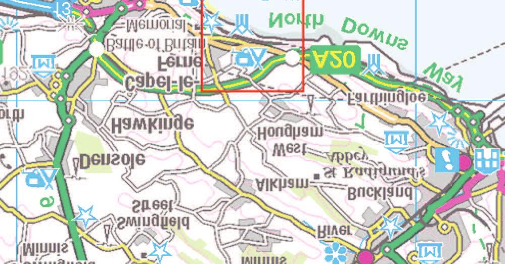
9 Folkestone Warren High Cliff Instrumentation, Kent v1.0 1 INTRODUCTION 1.1 Scope of work Between 19th and 25th January 2017 Oxford Archaeology (OA) undertook an archaeological watching brief on trenching work during the installation of underground geotechnical instrumentation and monitoring equipment on the chalk cliffs at Folkestone Warren, Kent (Fig. 1). This report details the results of the fieldwork The work was undertaken as a condition of planning permission (planning ref: DOV/16/00778). Although the Local Planning Authority had not set a brief for the work, discussions with Kent County Council established the scope of work required. Subsequent to this OA produced a Written Scheme of Investigation (WSI) which outlined how OA would implement those requirements (OA 2016). 1.2 Location, topography and geology The site is centred on National Grid Reference TR (Fig. 1). The general location and layout of the excavation works is shown on Fig. 2 (Costain drawing COT-DRG-EGE ) The site consists of cliff top scrubland, with a slope and cliff edge to the south and the Old Dover Road immediately to the north The geology of the area is Lewes Nodular Chalk Formation, chalk bedrock overlain by a superficial deposit of clay-with-flints (BGS nd) Folkestone Warren is designated as a Site of Special Scientific Interest (SSSI), although the geotechnical monitoring installation trenches lie outside the SSSI boundary to the north. 1.3 Archaeological and historical background As no formal desk-based assessment was requested the following background section is based on published and online sources, primarily the Kent County Council (KCC) Historic Environment Record (HER) and National Monuments Record (NMR), obtained via the Heritage Gateway website (KCC HER nd) The archaeological record for this area is relatively sparse. Nevertheless a number of important features are recorded on the KCC HER in the immediate vicinity, as summarised below. Prehistoric middle Bronze-Age A middle Bronze Age bowl barrow is situated immediately east of the site (labelled tumulus on Figure 2). An inverted biconical urn was recovered from the top of the mound, whilst a cremation deposit was found at the east end of the southern part of the barrow. No ditch can be seen (Kent HER number TR23 NE2). Oxford Archaeology Ltd 1 31 March 2017
10 Folkestone Warren High Cliff Instrumentation v1.0 Modern Several modern features are recorded in the immediate vicinity of the site, which relate to WW1, WW2 and interwar defence installations A Royal Naval Air Service airship base, dating from 1915, formerly lay to the north-east of the monitoring site. The base included at least four airship hangars and ancillary buildings, of which only a single extant earthwork can now be seen (Kent HER number TR23 NE29). The site is now a caravan park, and some of the roads within the park follow the same line as the original airfield roads A sound mirror and associated building platform were constructed at Abbot's Cliff in 1928 (Kent HER number TR 23 NE 32). An associated antenna is located 190 metres to the west (NMR number ). This 20ft (6.1m) mirror was built as one of a pair of mirrors to bracket the Acoustic Research Station at Hythe, the second mirror being located at Denge (NMR number ) Several WW2 anti-aircraft batteries, near Capel Court Farm, have been recorded from aerial photographs, although no visible sign of them remains (Kent HER numbers MWX51336, , , and ) A WW2 observation post was recorded near the site from aerial photographs, taken in 1946 (Kent HER number MWX51358). Subsequent aerial photographs from 1966 show that the building were demolished by that date A WW2 slit trench was recorded immediately north of the Old Dover Road on aerial photographs taken in 1946 (Kent HER number MWX51419), adjoining the site. Aerial photographs taken in 1966 show that the site had been levelled by that date The Battle of Britain Memorial is located within the Capel Battery, a gun position built in 1941 on the cliff tops of Capel-Le-Ferne between Dover and Folkestone, c 2km WSW from the site. Oxford Archaeology Ltd 2 31 March 2017
11 Folkestone Warren High Cliff Instrumentation, Kent v1.0 2 WATCHING BRIEF AIMS AND METHODOLOGY 2.1 General aims and objectives The general aims and objectives of the watching brief were to: i. determine the location, extent, date, character, condition, significance and quality of any archaeological remains within the site; ii. assess vulnerability/sensitivity of any exposed archaeological remains; iii. determine the potential of the site to provide palaeoenvironmental and/or economic evidence; iv. provide sufficient information on the archaeological potential of the site to enable the archaeological implications of any proposed developments to be assessed; v. disseminate the results through the production of a site archive for deposition with an appropriate museum and to provide information for accession to the Kent HER. 2.2 Specific aims and objectives The specific aims and objectives of the evaluation were to: vi. 2.3 Methodology identify and record any archaeological remains or artefacts that may be revealed within the excavations that could relate to the recorded middle Bronze Age bowl barrow and 20th-century defence installations All archaeological work and the preparation of this report was conducted according to relevant professional standards and guidelines, as detailed in the WSI, in particular the CIfA, All spoil from the excavations was scanned visually for artefacts and ecofacts. Artefacts which were clearly modern and irrelevant to the project objectives were noted but not retained All revealed deposits and features were cleaned and investigated by hand All records and finds were labelled with the Event Site Code (FOLKWN17) On site recording followed procedures detailed in the OA Fieldwork Manual (Wilkinson 1992) and relevant CIfA guidelines (CIfA 2014) All features and deposits were issued with unique context numbers, and context recording was in accordance with established OA South practices Written descriptions were recorded on proforma sheets comprising factual data and interpretative elements Where stratified deposits were encountered a stratigraphic "Harris matrix" was compiled during the course of the excavation A photographic record was taken of all excavations, general settings and archaeological sections. Oxford Archaeology Ltd 3 31 March 2017
12 Folkestone Warren High Cliff Instrumentation v Sample sections were drawn at a scale of 1: The positions of the trenches was verified by the OA archaeologist through discussion with the contractor, using the design drawings. In this way it was possible to ensure that all interventions or excavation limits, and significant archaeology detail were surveyed as dug, before leaving the site All levels recorded were taken from known points and recorded as metres above Ordnance Datum (maod). Oxford Archaeology Ltd 4 31 March 2017
13 Folkestone Warren High Cliff Instrumentation, Kent v1.0 3 RESULTS 3.1 Introduction and presentation of results The results of the watching brief are presented below, and include a stratigraphic description of the excavations. The full details of all trenches with dimensions and depths of all deposits for the content of Appendix A. Finds data and spot dates are presented in Appendix B Context numbers reflect the trench numbers unless otherwise stated. For example, pit 102 is a feature within Trench 1, while ditch 304 is a feature within Trench An archaeologist from OA was present during the machine excavation of: i. two 12m x 1.2m and 1.5m deep trenches (Trenches A and B), for the installation of geotechnical monitoring equipment (Fig. 2, Plates 1 4); ii. one 1.2. x 0.7m and 0.7m deep chamber for the installation of data logging and transmission equipment (Fig. 2, Plate 5); iii. one 0.60m deep data/power cable trench linking the two monitoring equipment trenches with the data logging and transmission chamber (Fig. 2, Plate 6). 3.2 General soils and ground conditions Ground conditions throughout the watching brief permitted good archaeological visibility. The excavations were completed in dry weather conditions The earliest deposit observed was the clay-with-flints superficial geology, which was present throughout the site to a depth of c 1.8m below present ground level. This deposit was overlain by a c 0.5m thick deposit of mixed greyish brown silty sand (101 - colluvium). The colluvium was in turn covered by a 0.2m thick mid brownish grey clay silt topsoil (100). 3.3 Description of archaeological deposits Within the data logging chamber a NE-SW aligned 1.2m deep vertical-sided cut (103, Plate 5) was observed. This was filled with a modern rubble backfill (104). The material infilling the trench contained fragments from two government issue mugs, dated 1941 and 1944 respectively (see Appendix 2 for details). This feature, which was cut through the colluvium (101), appears to be the infilled remains of a WW2 trench, probably associated with an anti-aircraft battery and observation post which stood near the site, as recorded on wartime aerial photographs No other archaeological deposits, structures or features were uncovered during the works. 3.4 Finds summary A very small number of finds were recovered during the watching brief, including a single undated struck flint recovered from colluvial layer 101, which could belong to any prehistoric period up to the Bronze Age. Oxford Archaeology Ltd 5 31 March 2017
14 Folkestone Warren High Cliff Instrumentation v Fragments of two white-glazed handled mugs from the rubble backfill (103) of feature 104. These are dated by maker s marks to WW Environmental remains Due to the absence of suitable deposits, no samples were taken for environmental analysis. Oxford Archaeology Ltd 6 31 March 2017
15 Folkestone Warren High Cliff Instrumentation, Kent v1.0 4 DISCUSSION 4.1 Watching brief objectives and results Very slight evidence for prehistoric activity was found in the form of a single worked flint of uncertain date. The watching brief does not shed much useful light on the adjacent middle Bronze Age bowl barrow, other than to suggest that further funerary monuments do not appear to have extended into the watching brief area The probable infilled WW2 trench is most likely to be associated with an anti-aircraft battery and observation post which is shown on aerial photographs lying close to the site. The Folkestone area was on the front line in the aerial battles of WW1 and WW2, and has a rich legacy of defence features dating from those conflicts and the interwar years. The discovered trench is a minor and poorly preserved element of this unique landscape No other archaeological deposits, structures or features were uncovered during the works. Oxford Archaeology Ltd 7 31 March 2017
16 Folkestone Warren High Cliff Instrumentation v1.0 APPENDIX A CONTEXT INVENTORY Context Type Depth below ground level (bgl) Comments 100 Deposit 0.0m-0.3m Topsoil: Mid brownish grey clay silt, rare sub angular pebbles up to 60mm in diameter, 101 Deposit 0.3m-0.7m Sub soil (colluvium): Moderately compact, mixed mid greyish brown with yellowish red patches, silty sand rubble mixed with chalk and flint 102 Deposit 0.7m-1.8m (+) Clay-with-flints (superficial geology). Firm mid brownish yellow sandy clay, with occasional flint and chalk nodules 103 Cut Top- 0.2m Base -1.4m 104 Deposit Top- 0.2m Base -1.4m Construction cut of infilled trench: NE-SE aligned linear cut, near vertical sides, concave base Backfill of cut 103: Pale grey with blueish black patches; Loose rubble in a silty sand matrix. Modern demolition rubble including fragments of crushed tarmac Finds - Worked flint (undated) - See fill 104 Two white ceramic mugs with dated makers marks (1941 and 1944). Oxford Archaeology Ltd 8 31 March 2017
17 Folkestone Warren High Cliff Instrumentation, Kent v1.0 APPENDIX B FINDS REPORTS B.1 Pottery By John Cotter B.1.1 The rubble backfill of the WW2 trench found in the data logging and transmission chamber (context 104) produced two almost complete wartime issue tea or coffee mugs in white 'china', both with dated marks. These comprise 7 sherds weighing 709g. No other pottery was recovered. B.1.2 Fabric codes referred to in this report are those of the Museum of London (MoLA 2014). The two mugs (here referred to as Mug 1 and Mug 2) are in a refined white earthenware with transfer-printed marks on the base (Fabric code TPW) but are otherwise undecorated. These have not been separately catalogued but are fully described below. Mug 1 (dated 1941) B.1.3 An almost complete cylindrical mug represented by 5 sherds (weight: 385g). One hundred percent of the rim circumference survives and around 80% of the base. Height: 101mm. Rim diameter: 101mm. Base (and body) diameter: mm. Plain vertical rim. Slightly recessed flat base. Complete solid and robust bracket-like handle made in a separate mould and then applied to the vessel. A light moulded border line defines the outline of the handle and the oval loop-hole for the finger. A faint casting seam is visible down the back of the handle and inside the loop-hole. The vessel body is machine-made rather than wheel-thrown by hand. Fine, very hard, off-white or pale ivory-coloured body with an all over clear glaze with a slightly greyish tint. The underside has an off-centre (lower right) maker s mark in green transfer printing as follows [Nb. The / slash symbol indicates separate lines of inscribed text]: GEO. ASHWORTH/ & BROS. LTD./ W [inside green lozenge]/ The mark is 24mm wide (max.) and 23mm deep and the layout or design is centred and symmetrical. The ink is greyish-green and the lettering small and slightly fuzzy in places but still legible. The W in the green lozenge probably stands for Warranted, or less likely Wartime issue. Some use-wear to the base footring is evident. B.1.4 The pottery manufacturers George L Ashworth and Brothers were based at the Broad Street Works, Hanley, Stoke-on-Trent (Staffordshire) between 1861 and 1968 (source: (accessed Feb 2017). Mug 2 (dated 1944) B.1.5 A cylindrical mug profile, about half-complete, represented by 2 sherds (weight: 324g). 24% of the rim circumference survives and 100% of the base. Height: 103mm. Rim diameter: c 100mm. Base (and body) diameter: 97mm. Complete handle. Vessel and handle form details almost exactly as Mug 1 above but the slight variations evident (as well as the markings) point to it being from a different manufacturer. The handle in particular has a more rounded cross-section and is more rounded in side view at the Oxford Archaeology Ltd 9 31 March 2017
18 Folkestone Warren High Cliff Instrumentation v1.0 top than Mug 1. The handle also lacks the casting seam seen above and the border line is only faintly defined - features demonstrating that the handles of these two mugs came out of different moulds. Mug 2 is also more thickly potted than Mug 1 and has a creamy-white fabric and very little greyish tint to the glaze. The footring shows slight use-wear. B.1.6 The underside has an off-centre (upper left) maker s mark in black or dark grey transfer printing as follows: C./ G.vi.R./ NELSON WARE/ 1944/ ENGLAND. The mark is 31mm wide (max.) and 28mm deep and the layout or design is centred and symmetrical. The ink slightly fuzzy in places but still legible. The meaning of the large letter C, above the royal monogram of King George VI, is unknown. B.1.7 Nelson ware was a trade name used from c 1913 by the pottery manufacturer Elijah Cotton of Hanley, Stoke-on-Trent. The firm had two factories there, one called the Nelson Pottery and the other the Victoria Pottery. The firm was in existence between c 1885 and 1981 (source: (accessed Feb 2017). Conclusions B.1.8 Cylindrical whiteware mugs and smaller teacups with these distinctive solid bracketlike handles (derived from the Art Deco-style) are typical of wartime issue canteen ware from many WW2 contexts up and down the country, such as air-raid shelters and military bases etc. The royal monogram and date identify these as wartime issue pieces beyond any doubt. Although identical vessel forms are known from domestic wartime and peacetime contexts, they do not generally carry the royal monogram and date. Tableware services, such as these, were often commissioned direct from Staffordshire suppliers by large organisations or companies for use anywhere where the organisation had offices or premises. In this case it is almost certain that the tablewares were part of a War Department (or MoD) commission to supply military bases with a standard issue of serviceable pottery. B.1.9 Despite their fragmentary condition the wartime vessels here are an interesting find. They provide dating evidence with a degree of accuracy rarely found in pottery assemblages and a useful snapshot, furthermore, of the types of pottery used on military bases etc, as well as the names of manufacturers who supplied them. The range of named Staffordshire manufacturers seems to vary from one part of the country to the other suggesting that different regions were supplied from different depots and via different supply routes. Very little detailed work on this subject has been published so the two mugs here are a useful addition to this subject. B.2 Worked flint by Michael Donnelly B.2.1 A single flint was recovered during the watching brief. The flint represents a distal trimming flake and is quite regular in form but displays a very pronounced hardhammer bulb. The pieces is moderately edge damaged and heavily patinated. The flint Oxford Archaeology Ltd March 2017
19 Folkestone Warren High Cliff Instrumentation, Kent v1.0 was found as a stray find in the topsoil/subsoil and could belong to any prehistoric period. Oxford Archaeology Ltd March 2017
20 Folkestone Warren High Cliff Instrumentation v1.0 APPENDIX C BIBLIOGRAPHY BGS nd, British Geological Survey CIfA 2014 Standard and guidance for an archaeological watching brief, Chartered Institute for Archaeologists KCC HER nd, Kent Historic Environment Record, via Heritage Gateway ( MoLA 2014 Medieval and post-medieval pottery codes: OA 2016 Folkestone Warren, Kent. Written Scheme of Investigation for a Watching Brief Wilkinson, D (ed.), 1992 OAU Fieldwork Manual Oxford Archaeology Ltd March 2017
21 Folkestone Warren High Cliff Instrumentation, Kent v1.0 APPENDIX D SITE SUMMARY DETAILS Site name: Folkestone Warren High Cliff Instrumentation Site code: FOLKWN16 Grid Reference TR Type: Watching brief Date and duration: January 2017 (5 days) Summary of Results: Oxford Archaeology (OA) undertook an archaeological watching brief on trenching work during the installation of underground instrumentation and monitoring equipment on the top of the chalk cliffs at Folkestone Warren, Kent. A single struck flint, which is not closely datable, was uncovered from a colluvial layer, and is the only evidence for prehistoric activity found during the watching brief. The site is located next to a middle Bronze Age bowl barrow (Kent HER no.tr23 NE29). A 1.4m deep, NE-SW aligned, vertical sided cut was identified within the data-logging chamber. The material infilling the trench contained fragments from two government issue mugs, dated 1941 and 1944 respectively. This feature appears to be the infilled remains of a WW2 trench, probably associated with an anti-aircraft battery and observation post which stood near the site, as recorded on wartime aerial photographs. No other archaeological deposits or structures were discovered during the works. Area of Site Location of archive: N/A The archive is currently held at OA, Janus House, Osney Mead, Oxford, OX2 0ES, and will be deposited with the relevant museum in due course. Oxford Archaeology Ltd March 2017


22 BIRMINGHAM NORWICH OXFORD LONDON \\ \invoice codes a thru h\f_invoice codes\folkwnwb\folkwnwb_fig_01.mxd*markus.dylewski*01/02/ Site location Contains Ordnance Survey data Crown copyright and database right 2014 (c) OpenStreetMap and contributors, Creative Commons-Share Alike License (CC-BY- SA) 1:15,000 Figure 1: Site location

23 \\ \invoice codes a thru h\f_invoice codes\folkwnwb*md*1.2.17


24 \\ \invoice codes a thru h\f_invoice codes\folkwnwb*md* Plate 1: West facing representative section Trench A. Showing archaeological sequence exposed Plate 2: Trench A working shot


25 \\ \invoice codes a thru h\f_invoice codes\folkwnwb*md* Plate 3: Trench B working shot Plate 4: Trench B working shot


26 \\ \invoice codes a thru h\f_invoice codes\folkwnwb*md* Plate 5: North facing section of data logging chamber showing archaeological sequence with modern cut [103] to the right Plate 6: Cable trench working shot
27
28
Archaeological. Monitoring & Recording Report. Fulbourn Primary School, Cambridgeshire. Archaeological Monitoring & Recording Report.
 Fulbourn Primary School, Cambridgeshire Archaeological Monitoring & Recording Report October 2014 Client: Cambridgeshire County Council OA East Report No: 1689 OASIS No: oxfordar3-192890 NGR: TL 5190 5613
New Composting Centre, Ashgrove Farm, Ardley, Oxfordshire
 New Composting Centre, Ashgrove Farm, Ardley, Oxfordshire An Archaeological Watching Brief For Agrivert Limited by Andrew Weale Thames Valley Archaeological Services Ltd Site Code AFA 09/20 August 2009
An archaeological evaluation at 16 Seaview Road, Brightlingsea, Essex February 2004
 An archaeological evaluation at 16 Seaview Road, Brightlingsea, Essex February 2004 report prepared by Kate Orr on behalf of Highfield Homes NGR: TM 086 174 (c) CAT project ref.: 04/2b ECC HAMP group site
ARCHAEOLOGICAL EVALUATION AT BRIGHTON POLYTECHNIC, NORTH FIELD SITE, VARLEY HALLS, COLDEAN LANE, BRIGHTON. by Ian Greig MA AIFA.
 ARCHAEOLOGICAL EVALUATION AT BRIGHTON POLYTECHNIC, NORTH FIELD SITE, VARLEY HALLS, COLDEAN LANE, BRIGHTON by Ian Greig MA AIFA May 1992 South Eastern Archaeological Services Field Archaeology Unit White
Church of St Peter and St Paul, Great Missenden, Buckinghamshire
 Church of St Peter and St Paul, Great Missenden, Buckinghamshire An Archaeological Watching Brief for the Parish of Great Missenden by Andrew Taylor Thames Valley Archaeological Services Ltd Site Code
Grim s Ditch, Starveall Farm, Wootton, Woodstock, Oxfordshire
 Grim s Ditch, Starveall Farm, Wootton, Woodstock, Oxfordshire An Archaeological Recording Action For Empire Homes by Steve Ford Thames Valley Archaeological Services Ltd Site Code SFW06/118 November 2006
Archaeological Evaluation at Alconbury Weald Enterprise Zone
 Archaeological Evaluation at Alconbury Weald Enterprise Zone Archaeological Evaluation Report June 2015 Client: CgMS OA East Report No: 1768 OASIS No: oxfordar3-212519 NGR: TL 1975 7684 Archaeological
Oxfordshire. Wallingford. St Mary-le-More. Archaeological Watching Brief Report. Client: JBKS Architects and St Mary s Renewal Campaign.
 St Mary-le-More Wallingford Oxfordshire Archaeological Watching Brief Report February 2010 Client: JBKS Architects and St Mary s Renewal Campaign Issue No:1 OA Job No: 4432 NGR: SU 6071 8933 Archaeological
39, Walnut Tree Lane, Sudbury (SUY 073) Planning Application No. B/04/02019/FUL Archaeological Monitoring Report No. 2005/112 OASIS ID no.
 Planning Application No. B/04/02019/FUL Archaeological Monitoring Report No. 2005/112 OASIS ID no.") 39, Walnut Tree Lane, Sudbury (SUY 073) Planning Application No. B/04/02019/FUL Archaeological Monitoring Report No. 2005/112 OASIS ID no. 9273 Summary Sudbury, 39, Walnut Tree Lane, Sudbury (TL/869412;
39, Walnut Tree Lane, Sudbury (SUY 073) Planning Application No. B/04/02019/FUL Archaeological Monitoring Report No. 2005/112 OASIS ID no. 9273 Summary Sudbury, 39, Walnut Tree Lane, Sudbury (TL/869412;
Archaeological evaluation at the Onley Arms, The Street, Stisted, Essex
 Archaeological evaluation at the Onley Arms, The Street, Stisted, Essex November 2014 report by Pip Parmenter and Adam Wightman with a contribution from Stephen Benfield and illustrations by Emma Holloway
An archaeological evaluation by trial-trenching at Playgolf, Bakers Lane, Westhouse Farm, Colchester, Essex
 An archaeological evaluation by trial-trenching at Playgolf, Bakers Lane, Westhouse Farm, Colchester, Essex commissioned by Mr Stephen Belchem on behalf of ADP Ltd. report prepared by Chris Lister Planning
Archaeological Watching Brief (Phase 2) at Court Lodge Farm, Aldington, near Ashford, Kent December 2011
 at Court Lodge Farm, Aldington, near Ashford, Kent December 2011") Archaeological Watching Brief (Phase 2) at Court Lodge Farm, Aldington, near Ashford, Kent December 2011 SWAT. Archaeology Swale and Thames Archaeological Survey Company School Farm Oast, Graveney Road
Archaeological Watching Brief (Phase 2) at Court Lodge Farm, Aldington, near Ashford, Kent December 2011 SWAT. Archaeology Swale and Thames Archaeological Survey Company School Farm Oast, Graveney Road
2 Saxon Way, Old Windsor, Berkshire
 2 Saxon Way, Old Windsor, Berkshire An Archaeological Watching Brief For Mrs J. McGillicuddy by Pamela Jenkins Thames Valley Archaeological Services Ltd Site Code SWO 05/67 August 2005 Summary Site name:
Archaeological Evaluation Report
 16-18 Church Street Brill Buckinghamshire o a February 2008 Client: Stephen Moss Developments Issue N o : 1 OA Job N o : 3858 Planning Ref N o : 06/01304 NGR: SP 6553 1377 Client Name: Stephen Moss Developments
ARCHAEOLOGICAL MONITORING REPORT
 ARCHAEOLOGICAL MONITORING REPORT SCCAS REPORT No. 2009/324 Thorington Hall, Stoke by Nayland SBN 087 HER Information Date of Fieldwork: November 2009 - January 2010 Grid Reference: TM 0131 3546 Funding
Essex Historic Environment Record/ Essex Archaeology and History
 Essex Historic Environment Record/ Essex Archaeology and History CAT Report 578 Summary sheet Address: Kingswode Hoe School, Sussex Road, Colchester, Essex Parish: Colchester NGR: TL 9835 2528 Type of
An archaeological watching brief and recording at Brightlingsea Quarry, Moverons Lane, Brightlingsea, Essex October 2003
 An archaeological watching brief and recording at Brightlingsea Quarry, Moverons Lane, Brightlingsea, Essex commissioned by Mineral Services Ltd on behalf of Alresford Sand & Ballast Co Ltd report prepared
Silwood Farm, Silwood Park, Cheapside Road, Ascot, Berkshire
 Silwood Farm, Silwood Park, Cheapside Road, Ascot, Berkshire An Archaeological Watching Brief For Imperial College London by Tim Dawson Thames Valley Archaeological Services Ltd Site Code SFA 09/10 April
An archaeological evaluation at the Blackwater Hotel, Church Road, West Mersea, Colchester, Essex March 2003
 An archaeological evaluation at the Blackwater Hotel, Church Road, West Mersea, Colchester, Essex report prepared by Laura Pooley on behalf of Dolphin Developments (U.K) Ltd NGR: TM 0082 1259 CAT project
Colchester Archaeological Trust Ltd. A Fieldwalking Survey at Birch, Colchester for ARC Southern Ltd
 Colchester Archaeological Trust Ltd A Fieldwalking Survey at Birch, Colchester for ARC Southern Ltd November 1997 CONTENTS page Summary... 1 Background... 1 Methods... 1 Retrieval Policy... 2 Conditions...
Excavation. Post-Medieval Ditches. Land off Norwich Common Road Wymondham Norfolk. Excavation. Client: November 2013
 Land off Norwich Common Road Wymondham Norfolk. Excavation November 2013 Client: OA East Report No: 1546 OASIS No: oxfordar3-163105 NGR: TG 12770 02684 Excavation Post-Medieval Ditches Post-Medieval Ditches
Test-Pit 3: 31 Park Street (SK )
") -Pit 3: 31 Park Street (SK 40732 03178) -Pit 3 was excavated in a flower bed in the rear garden of 31 Park Street, on the northern side of the street and west of an alleyway leading to St Peter s Church,
-Pit 3: 31 Park Street (SK 40732 03178) -Pit 3 was excavated in a flower bed in the rear garden of 31 Park Street, on the northern side of the street and west of an alleyway leading to St Peter s Church,
Grange Farm, Widmer End, Hughenden, Buckinghamshire
 Grange Farm, Widmer End, Hughenden, Buckinghamshire An Archaeological Evaluation for British Flora by Andy Taylor Thames Valley Archaeological Services Ltd Site Code GFH 05/63 July 2005 Summary Site name:
Former Whitbread Training Centre Site, Abbey Street, Faversham, Kent Interim Archaeological Report Phase 1 November 2009
 Former Whitbread Training Centre Site, Abbey Street, Faversham, Kent Interim Archaeological Report Phase 1 November 2009 SWAT. Archaeology Swale and Thames Archaeological Survey Company School Farm Oast,
Fieldwalking at Cottam 1994 (COT94F)
") Fieldwalking at Cottam 1994 (COT94F) Tony Austin & Elizabeth Jelley (19 Jan 29) 1. Introduction During the winter of 1994 students from the Department of Archaeology at the University of York undertook
Fieldwalking at Cottam 1994 (COT94F) Tony Austin & Elizabeth Jelley (19 Jan 29) 1. Introduction During the winter of 1994 students from the Department of Archaeology at the University of York undertook
E x cav atio n R e p o r t
 Medieval Trackway on land at Ivy Farm Royston, Hertfordshire Excavation Report E x cav atio n R e p o r t October 2011 Client: CgMs Consulting OA East Report No: 1305 OASIS No: oxfordar3-112012 NGR: TL
An archaeological evaluation at the Lexden Wood Golf Club (Westhouse Farm), Lexden, Colchester, Essex
, Lexden, Colchester, Essex") An archaeological evaluation at the Lexden Wood Golf Club (Westhouse Farm), Lexden, Colchester, Essex January 2000 Archive report on behalf of Lexden Wood Golf Club Colchester Archaeological Trust 12 Lexden
An archaeological evaluation at the Lexden Wood Golf Club (Westhouse Farm), Lexden, Colchester, Essex January 2000 Archive report on behalf of Lexden Wood Golf Club Colchester Archaeological Trust 12 Lexden
An archaeological evaluation in the playground of Colchester Royal Grammar School, Lexden Road, Colchester, Essex
 An archaeological evaluation in the playground of Colchester Royal Grammar School, Lexden Road, Colchester, Essex February 2002 on behalf of Roff Marsh Partnership CAT project code: 02/2c Colchester Museum
Moated Site at Manor Farm, Islip, Oxfordshire
 Moated Site at Manor Farm, Islip, Oxfordshire An Archaeological Excavation By Jo Pine Site Code MFI05 December 2007 Summary Site name: Moated Site at Manor Farm, Islip, Oxfordshire Grid reference: SP 5298
3. The new face of Bronze Age pottery Jacinta Kiely and Bruce Sutton
 3. The new face of Bronze Age pottery Jacinta Kiely and Bruce Sutton Illus. 1 Location map of Early Bronze Age site at Mitchelstown, Co. Cork (based on the Ordnance Survey Ireland map) A previously unknown
Greater London GREATER LONDON 3/606 (E ) TQ
 TQ") GREATER LONDON City of London 3/606 (E.01.6024) TQ 30358150 1 PLOUGH PLACE, CITY OF LONDON An Archaeological Watching Brief at 1 Plough Place, City of London, London EC4 Butler, J London : Pre-Construct
GREATER LONDON City of London 3/606 (E.01.6024) TQ 30358150 1 PLOUGH PLACE, CITY OF LONDON An Archaeological Watching Brief at 1 Plough Place, City of London, London EC4 Butler, J London : Pre-Construct
Undley Hall, Lakenheath LKH 307
 ARCHAEOLOGICAL EVALUATION AND MONITORING REPORT SCCAS REPORT No. 2010/005 Undley Hall, Lakenheath LKH 307 E. Muldowney SCCAS January 2010 www.suffolkcc.gov.uk/e-and-t/archaeology Lucy Robinson, County
Erection of wind turbine, Mains of Loanhead, Old Rayne, AB52 6SX
 Erection of wind turbine, Mains of Loanhead, Old Rayne, AB52 6SX Ltd 23 November 2011 Erection of wind turbine, Mains of Loanhead, Old Rayne, AB52 6SX CONTENTS 1 INTRODUCTION 3 2 ARCHAEOLOGICAL BACKGROUND
Small Finds Assessment, Minchery Paddock, Littlemore, Oxford (MP12)
") Small s Assessment, Minchery Paddock, Littlemore, Oxford (MP12) Introduction A total of 51 objects recovered from excavations at Minchery Paddock, Littlemore, Oxford (MP12) were submitted for dating and
Small s Assessment, Minchery Paddock, Littlemore, Oxford (MP12) Introduction A total of 51 objects recovered from excavations at Minchery Paddock, Littlemore, Oxford (MP12) were submitted for dating and
Greater London Region GREATER LONDON 3/567 (E.01.K099) TQ BERMONDSEY STREET AND GIFCO BUILDING AND CAR PARK
 TQ BERMONDSEY STREET AND GIFCO BUILDING AND CAR PARK") GREATER LONDON 3/567 (E.01.K099) TQ 33307955 156-170 BERMONDSEY STREET AND GIFCO BUILDING AND CAR PARK Assessment of an Archaeological Excavation at 156-170 Bermondsey Street and GIFCO Building and Car
GREATER LONDON 3/567 (E.01.K099) TQ 33307955 156-170 BERMONDSEY STREET AND GIFCO BUILDING AND CAR PARK Assessment of an Archaeological Excavation at 156-170 Bermondsey Street and GIFCO Building and Car
Archaeological sites and find spots in the parish of Burghclere - SMR no. OS Grid Ref. Site Name Classification Period
 Archaeological sites and find spots in the parish of Burghclere - SMR no. OS Grid Ref. Site Name Classification Period SU45NE 1A SU46880 59200 Ridgemoor Farm Inhumation Burial At Ridgemoor Farm, on the
An archaeological watching brief at Sheepen, Colchester, Essex November-December 2003
 An archaeological watching brief at Sheepen, Colchester, Essex November-December 2003 report prepared by Ben Holloway on behalf of Colchester Borough Council CAT project ref.: 03/11c Colchester Museums
Archaeological trial-trenching evaluation at Chappel Farm, Little Totham, Essex. April 2013
 Archaeological trial-trenching evaluation at Chappel Farm, Little Totham, Essex April 2013 report prepared by Ben Holloway commissioned by Tim Harbord Associates on behalf of Mr Tom Howie Planning reference:
ARCHAEOLOGICAL EVALUATION REPORT. Home Farm, Woolverstone
 ARCHAEOLOGICAL EVALUATION REPORT Home Farm, Woolverstone WLV 047 A REPORT ON THE ARCHAEOLOGICAL EVALUATION, 2007 Kieron Heard Field Team Suffolk County Council Archaeological Service December 2007 Lucy
Monitoring Report No. 99
 Monitoring Report No. 99 Enniskillen Castle Co. Fermanagh AE/06/23 Cormac McSparron Site Specific Information Site Name: Townland: Enniskillen Castle Enniskillen SMR No: FER 211:039 Grid Ref: County: Excavation
FURTHER MIDDLE SAXON EVIDENCE AT COOK STREET, SOUTHAMPTON (SOU 567)
") Roc. Hampshire Field Club Archaeol. Soc 52,1997, 77-87 (Hampshire Studies 1997) FURTHER MIDDLE SAXON EVIDENCE AT COOK STREET, SOUTHAMPTON (SOU 567) By M F GARNER andj VINCENT with a contribution byjacqueline
Roc. Hampshire Field Club Archaeol. Soc 52,1997, 77-87 (Hampshire Studies 1997) FURTHER MIDDLE SAXON EVIDENCE AT COOK STREET, SOUTHAMPTON (SOU 567) By M F GARNER andj VINCENT with a contribution byjacqueline
SALVAGE EXCAVATIONS AT OLD DOWN FARM, EAST MEON
 Proc. Hants. Field Club Archaeol. Soc. 36, 1980, 153-160. 153 SALVAGE EXCAVATIONS AT OLD DOWN FARM, EAST MEON By RICHARD WHINNEY AND GEORGE WALKER INTRODUCTION The site was discovered by chance in December
An archaeological evaluation by trial-trenching at Scotts Farm, Lodge Lane, Purleigh, Essex October 2011
 An archaeological evaluation by trial-trenching at Scotts Farm, Lodge Lane, Purleigh, Essex October 2011 report prepared by Adam Wightman on behalf of Richard Emans CAT project ref.: 11/10a NGR: TL 582719
C o w e s. Isle of Wight. BAE Systems Land. Archaeological Evaluation Report. Client: BAE Systems. November 2008
 BA Systems Land C o w e s Isle of ight Archaeological valuation Report November 2008 Client: BA Systems Issue No: 1 OA Job No: 4253 NGR: SZ 489 453 Archaeological valuation Report Client Name: BA Systems
ARCHAEOLOGICAL S E R V I C E S. St Nicholas' Church, Barrack Hill, Nether Winchendon, Buckinghamshire. Archaeological Watching Brief.
 T H A M E S V A L L E Y ARCHAEOLOGICAL S E R V I C E S St Nicholas' Church, Barrack Hill, Nether Winchendon, Buckinghamshire Archaeological Watching Brief by Steven Crabb Site Code: STW17/229 (SP 7735
Hayling School, Church Road, Hayling Island, Hampshire
 Hayling School, Church Road, Hayling Island, Hampshire An Archaeological Evaluation for George Wimpey Southern Ltd by Helen Moore Thames Valley Archaeological Services Ltd Site Code HSHI 03/46 July 2003
A visit to the Wor Barrow 21 st November 2015
 A visit to the Wor Barrow 21 st November 2015 Following our exploration of Winkelbury a few weeks previously, we fast forwarded 12 years in Pitt Rivers remarkable series of excavations and followed him
Monitoring Report No Sacred Heart Church Aghamore Boho Co. Fermanagh AE/10/116E. Brian Sloan L/2009/1262/F
 Monitoring Report No. 202 Sacred Heart Church Aghamore Boho Co. Fermanagh AE/10/116E Brian Sloan L/2009/1262/F Site Specific Information Site Address: Sacred Heart Church, Aghamore, Boho, Co. Fermanagh
1 The East Oxford Archaeology and History Project
 1 The East Oxford Archaeology and History Project EXOP TEST PIT 72 Location: Bartlemas Chapel, Cowley Date of excavation: 6-8 November 2013. Area of excavation: 0.8m x 1.2m, at the eastern end of the chapel.
An archaeological evaluation at Thistle Hall, Mope Lane, Wickham Bishops, Essex July 2009
 An archaeological evaluation at Thistle Hall, Mope Lane, Wickham Bishops, Essex July 2009 report prepared by Howard Brooks and Ben Holloway on behalf of Clarity Ecoworks Ltd CAT project ref.: 09/1f ECC
Chapter 2. Remains. Fig.17 Map of Krang Kor site
 Chapter 2. Remains Section 1. Overview of the Survey Area The survey began in January 2010 by exploring the site of the burial rootings based on information of the rooted burials that was brought to the
An archaeological watching brief at St Leonard s church, Hythe Hill, Colchester, Essex
 An archaeological watching brief at St Leonard s church, Hythe Hill, Colchester, Essex report prepared by Adam Wightman on behalf of Dorvell Construction CAT project ref.: 10/5d Colchester and Ipswich
THE RAVENSTONE BEAKER
 DISCOVERY THE RAVENSTONE BEAKER K. J. FIELD The discovery of the Ravenstone Beaker (Plate Xa Fig. 1) was made by members of the Wolverton and District Archaeological Society engaged on a routine field
Old Brewery Close and Walton Street, Aylesbury, Buckinghamshire
 Old Brewery Close and Walton Street, Aylesbury, Buckinghamshire An Archaeological Evaluation for Berkeley Homes (Oxford and Chiltern) Ltd by Sian Anthony Thames Valley Archaeological Services Ltd Site
NOTE A THIRD CENTURY ROMAN BURIAL FROM MANOR FARM, HURSTBOURNE PRIORS. by. David Allen with contributions by Sue Anderson and Brenda Dickinson
 Proc. Hampsh. Field Club Archaeol. Soc. 47, 1991, 253-257 NOTE A THIRD CENTURY ROMAN BURIAL FROM MANOR FARM, HURSTBOURNE PRIORS Abstract by. David Allen with contributions by Sue Anderson and Brenda Dickinson
Evidence for the use of bronze mining tools in the Bronze Age copper mines on the Great Orme, Llandudno
 Evidence for the use of bronze mining tools in the Bronze Age copper mines on the Great Orme, Llandudno Background The possible use of bronze mining tools has been widely debated since the discovery of
A Fieldwalking Project At Sompting. West Sussex
 by John Funnell Introduction A Fieldwalking Project At Sompting. West Sussex During March -and April 1995 the Brighton and Hove Archaeological Society conducted fie1dwa1king in a field at Sompting West
LAND WEST OF ELM GROVE, EBRINGTON, GLOUCESTERSHIRE. NGR: SP (centred) ARCHAEOLOGICAL EVALUATION
 ARCHAEOLOGICAL EVALUATION") LAND WEST OF ELM GROVE, EBRINGTON, GLOUCESTERSHIRE. NGR: SP 1892 4012 (centred) ARCHAEOLOGICAL EVALUATION Report No. 640 May 2009 1q LAND WEST OF ELM GROVE, EBRINGTON, GLOUCESTERSHIRE. NGR: SP 1892 4012
LAND WEST OF ELM GROVE, EBRINGTON, GLOUCESTERSHIRE. NGR: SP 1892 4012 (centred) ARCHAEOLOGICAL EVALUATION Report No. 640 May 2009 1q LAND WEST OF ELM GROVE, EBRINGTON, GLOUCESTERSHIRE. NGR: SP 1892 4012
An archaeological watching brief on one section of an Anglian Water main Spring Lane, Lexden, Colchester
 An archaeological watching brief on one section of an Anglian Water main Spring Lane, Lexden, Colchester April-September 2001 on behalf of Breheny Contractors CAT project ref.: 01/4D Colchester Museum
7. Prehistoric features and an early medieval enclosure at Coonagh West, Co. Limerick Kate Taylor
 7. Prehistoric features and an early medieval enclosure at Coonagh West, Co. Limerick Kate Taylor Illus. 1 Location of the site in Coonagh West, Co. Limerick (based on the Ordnance Survey Ireland map)
Wandsworth London. Alma Tavern. o a. A rch aeol ogi cal I nvestigation R eport. Client: Young s and Co. Brewery Plc and Nickless Allen.
 Alma Tavern Wandsworth London Archaeological Investigation Report o a April 2010 Client: Young s and Co. Brewery Plc and Nickless Allen Issue No: 1 NGR: TQ 260 750 A rch aeol ogi cal I nvestigation R eport
S E R V I C E S. St John the Baptist Church, Penshurst, Kent. Archaeological Watching Brief. by Daniel Bray and James McNicoll-Norbury
 T H A M E S V A L L E Y ARCHAEOLOGICAL S E R V I C E S St John the Baptist Church, Penshurst, Kent Archaeological Watching Brief by Daniel Bray and James McNicoll-Norbury Site Code: JPK11/25 (TQ 5273 4385)
Cambridge Archaeology Field Group. Fieldwalking on the Childerley Estate Cambridgeshire
 Cambridge Archaeology Field Group Fieldwalking on the Childerley Estate Cambridgeshire 2009 to 2014 Summary Fieldwalking on the Childerley estate of Martin Jenkins and Family has revealed, up to March
Land North of Pesthouse Lane Barham Suffolk BRH 054
 Land North of Pesthouse Lane Barham Suffolk BRH 054 Archaeological Evaluation Report SCCAS Report No. 2012/142 Client: Barham Parish Council Author: Jezz Meredith September 2012 SCCAS Land North of Pesthouse
Whitton Church Lane (Recreation Ground) WHI 014
 WHI 014") ARCHAEOLOGICAL EVALUATION REPORT Whitton Church Lane (Recreation Ground) WHI 014 A REPORT ON THE ARCHAEOLOGICAL EVALUATION, 2008 (Planning app. no. 1362/05/FUL) Jezz Meredith Field Team Suffolk C.C. Archaeological
ARCHAEOLOGICAL EVALUATION REPORT Whitton Church Lane (Recreation Ground) WHI 014 A REPORT ON THE ARCHAEOLOGICAL EVALUATION, 2008 (Planning app. no. 1362/05/FUL) Jezz Meredith Field Team Suffolk C.C. Archaeological
Lanton Lithic Assessment
 Lanton Lithic Assessment Dr Clive Waddington ARS Ltd The section headings in the following assessment report refer to those in the Management of Archaeological Projects (HBMC 1991), Appendix 4. 1. FACTUAL
An archaeological watching brief and evaluation at Great Notley business park, near Braintree, Essex June-September 2005
 An archaeological watching brief and evaluation at Great Notley business park, near Braintree, Essex report prepared by Kate Orr commissioned by Andrew Martin Associates Ltd on behalf of Countryside Properties
SERIATION: Ordering Archaeological Evidence by Stylistic Differences
 SERIATION: Ordering Archaeological Evidence by Stylistic Differences Seriation During the early stages of archaeological research in a given region, archaeologists often encounter objects or assemblages
TA 04/15 OASIS ID
 River Tees Rediscovered Project Archaeological Excavations in Egglescliffe Stockton on Tees 2015 TA 04/15 OASIS ID 1-238455 River Tees Rediscovered Project Archaeological Excavations in Egglescliffe Stockton
Archaeological Material From Spa Ghyll Farm, Aldfield
 Archaeological Material From Spa Ghyll Farm, Aldfield Introduction Following discussions with Linda Smith the Rural Archaeologist for North Yorkshire County Council, Robert Morgan of 3D Archaeological
Wantage County Primary School, Garston Lane, Wantage, Oxfordshire
 Wantage County Primary School, Garston Lane, Wantage, Oxfordshire An Archaeological Evaluation for Oxfordshire County Council by Erlend Hindmarch Thames Valley Archaeological Services Ltd Site Code GLW
Archaeological Evaluation of Land at the former HBC Engineering Site on Power Station Road, Minster, Sheppey, Kent
 Archaeological Evaluation of Land at the former HBC Engineering Site on Power Station Road, Minster, Sheppey, Kent NGR: 593312 173487 Site Code: PSR/EV/16 (Planning Application: SW/15/50508025) Date of
16 members of the Fieldwalking Group met York Community Archaeologist Jon Kenny at Lou Howard s farm, Rose Cottage Farm, at
 Terrington History Group Fieldwalking Group Field 1 Final report 21 October 2011 - fieldwalking 16 members of the Fieldwalking Group met York Community Archaeologist Jon Kenny at Lou Howard s farm, Rose
39 & 41 MEDINA AVENUE, NEWPORT, ISLE OF WIGHT AN ARCHAEOLOGICAL EVALUATION REPORT. Planning Application Ref: Pre-Application
 39 & 41 MEDINA AVENUE, NEWPORT, ISLE OF WIGHT AN ARCHAEOLOGICAL EVALUATION REPORT National Grid Reference: SZ 5025 8861 Planning Application Ref: Pre-Application By: AOC ARCHAEOLOGY GROUP Commissioned
BLEA TARN ROAD PIPELINE REPLACEMENT, LANCASTER, LANCASHIRE
 BLEA TARN ROAD PIPELINE REPLACEMENT, LANCASTER, LANCASHIRE Archaeological Watching Brief Report Oxford Archaeology North July 2006 RSK ENSR Environmental Ltd Issue No: 2006-7/538 OA North Job No: L9683
Archaeological Watching Brief Report
 Hampton Court Palace Signage Archaeological Watching Brief Report February 2011 Client: Historic Royal Palaces Issue No: 1 OA Job No: 4371 NGR: TQ 1560 6870 Archaeological Watching Brief Report Servergo:/oaupubs1_AthuH*HCP53*HCP53BS*Hampton
Museum of London Archaeological Archive: standards 2 Archive Components: Standards and Specifications 2.3 Finds
 Author Maloney, Cath. LAARC Version 3 Date 08/05/2013 Status Pre-publication Change History 2.9. Replacement of Registered Finds cards with image 2.3.4.3 2.8 Additions to Appendix: sample Finds Inventory
Archaeological trial-trenching evaluation at Dale Hall, Cox s Hill, Lawford, Essex
 Archaeological trial-trenching evaluation at Dale Hall, Cox s Hill, Lawford, Essex Fieldwork directed by Ben Holloway report prepared by Howard Brooks with a contribution by Stephen Benfield on behalf
AN EARLY MEDIEVAL RUBBISH-PIT AT CATHERINGTON, HAMPSHIRE Bj>J. S. PILE and K. J. BARTON
 AN EARLY MEDIEVAL RUBBISH-PIT AT CATHERINGTON, HAMPSHIRE Bj>J. S. PILE and K. J. BARTON INTRODUCTION THE SITE (fig. 21) is situated in the village of Catherington, one mile north-west of Horndean and 200
CUMBRIA 2/635 (C ) NY
 NY") CUMBRIA Allerdale 2/635 (C.16.6017) NY 11803070 BRIDGE STREET, COCKERMOUTH Report on an Archaeological Evaluation at Bridge Street, Cockermouth, Cumbria (Report No. 5/00) Grahame, R Carlisle : Carlisle
CUMBRIA Allerdale 2/635 (C.16.6017) NY 11803070 BRIDGE STREET, COCKERMOUTH Report on an Archaeological Evaluation at Bridge Street, Cockermouth, Cumbria (Report No. 5/00) Grahame, R Carlisle : Carlisle
Excavations at Shikarpur, Gujarat
 Excavations at Shikarpur, Gujarat 2008-2009 The Department of Archaeology and Ancient History, the M. S. University of Baroda continued excavations at Shikarpur in the second field season in 2008-09. In
The lithic assemblage from Kingsdale Head (KH09)
") 1 The lithic assemblage from Kingsdale Head (KH09) Hannah Russ Introduction During excavation the of potential Mesolithic features at Kingsdale Head in 2009 an assemblage of flint and chert artefacts were
1 The lithic assemblage from Kingsdale Head (KH09) Hannah Russ Introduction During excavation the of potential Mesolithic features at Kingsdale Head in 2009 an assemblage of flint and chert artefacts were
Control ID: Years of experience: Tools used to excavate the grave: Did the participant sieve the fill: Weather conditions: Time taken: Observations:
 Control ID: Control 001 Years of experience: No archaeological experience Tools used to excavate the grave: Trowel, hand shovel and shovel Did the participant sieve the fill: Yes Weather conditions: Flurries
Sussex, East Lewes Seaford Overlooking the mouth of the Cuckmere River on the W bank. Field Visit 2001/06/28
 5. Annex COMPONENTS OF DEFENCE AREA 14 Details of the defence works shown on Maps 2 and 3 are given below. The listing is arranged in sequence of the unique database record numbers that are also given
Eton College Courtyard Resurfacing Work, Windsor, Berkshire Archaeological Watching Brief Report. Client: Eton College. March 2017
 Eton College Courtyard Resurfacing Work, Windsor, Berkshire Archaeological Watching Brief Report March 2017 Client: Eton College Issue No: 1 OA Reference No: ETONSWB2 NGR: SU 96701 77909 Client Name:
Peace Hall, Sydney Town Hall Results of Archaeological Program (Interim Report)
") Results of Archaeological Program (Interim Report) Background The proposed excavation of a services basement in the western half of the Peace Hall led to the archaeological investigation of the space in
Results of Archaeological Program (Interim Report) Background The proposed excavation of a services basement in the western half of the Peace Hall led to the archaeological investigation of the space in
Report on an archaeological trial-trenching evaluation: proposed reservoir site, land north of Redgate House, Wherstead, Suffolk.
 Report on an archaeological trial-trenching evaluation: proposed reservoir site, land north of Redgate House, Wherstead, Suffolk. August-September 2010 report prepared by Ben Holloway and Howard Brooks
December 6, Paul Racher (P007) Archaeological Research Associates Ltd. 900 Guelph St. Kitchener ON N2H 5Z6
 Archaeological Research Associates Ltd. 900 Guelph St. Kitchener ON N2H 5Z6") Ministry of Tourism, Culture and Sport Culture Programs Unit Programs and Services Branch Culture Division 401 Bay Street, Suite 1700 Toronto ON M7A 0A7 Tel.: 416-314-2120 Ministère du Tourisme, de la
Ministry of Tourism, Culture and Sport Culture Programs Unit Programs and Services Branch Culture Division 401 Bay Street, Suite 1700 Toronto ON M7A 0A7 Tel.: 416-314-2120 Ministère du Tourisme, de la
Bronze Age 2, BC
 Bronze Age 2,000-600 BC There may be continuity with the Neolithic period in the Early Bronze Age, with the harbour being used for seasonal grazing, and perhaps butchering and hide preparation. In the
Barnet Battlefield Survey
 In terim report on the progress of the Barnet Battlefield Survey December 2016 The Barnet Battlefield Survey is an archaeological investigation into the 1471 Battle of Barnet. It aims to define more accurately
Fort Arbeia and the Roman Empire in Britain 2012 FIELD REPORT
 Fort Arbeia and the Roman Empire in Britain 2012 FIELD REPORT Background Information Lead PI: Paul Bidwell Report completed by: Paul Bidwell Period Covered by this report: 17 June to 25 August 2012 Date
Burrell Orchard 2014: Cleveland Archaeological Society Internship Amanda Ponomarenko The Ohio State University June - August 2014
 1 Burrell Orchard 2014: Cleveland Archaeological Society Internship Amanda Ponomarenko The Ohio State University June - August 2014 Selected for the 2014 Cleveland Archaeological Society Internship in
ROMAN AND MEDIEVAL ACTIVITY IN THE UPPER WALBROOK VALLEY: EXCAVATIONS AT MOORGATE, CITY OF LONDON, EC2, 1997
 ROMAN AND MEDIEVAL ACTIVITY IN THE UPPER WALBROOK VALLEY: EXCAVATIONS AT 12 18 MOORGATE, CITY OF LONDON, EC2, 1997 Graham Bruce, Dominic Perring, Tim Stevens and Melissa Melikian SUMMARY In January and
A Sense of Place Tor Enclosures
 A Sense of Place Tor Enclosures Tor enclosures were built around six thousand years ago (4000 BC) in the early part of the Neolithic period. They are large enclosures defined by stony banks sited on hilltops
The Swan Hotel, Lavenham LVM 080
 The Swan Hotel, Lavenham LVM 080 Post-Excavation Assessment Report v0.4 SCCAS Report No. 2013/148 Client: TA Hotel Collection Author: Rob Brooks December/2014 Suffolk County Council Archaeological Service
Suburban life in Roman Durnovaria
 Suburban life in Roman Durnovaria Additional specialist report Finds Ceramic building material By Kayt Brown Ceramic building material (CBM) Kayt Brown A total of 16420 fragments (926743g) of Roman ceramic
NGSBA Excavation Reports
 ISSN 2221-9420 NGSBA Excavation Reports Volume 1 (2009) Salvage Excavation at Nahal Saif 2004 Final Report Excavation Permit: B - 293/2004 Excavating Archaeologist: Yehuda Govrin Y. G. Contract Archaeology
STONES OF STENNESS HISTORIC ENVIRONMENT SCOTLAND STATEMENT OF SIGNIFICANCE
 Property in Care (PIC) ID: PIC321 Designations: Scheduled Monument (SM90285); Taken into State care: 1906 (Guardianship) Last reviewed: 2003 HISTORIC ENVIRONMENT SCOTLAND STATEMENT OF SIGNIFICANCE STONES
Cambridge Archaeology Field Group. Fieldwalking on the Childerley Estate, Cambridgeshire. Autumn 2014 to Spring Third interim report
 Cambridge Archaeology Field Group Fieldwalking on the Childerley Estate, Cambridgeshire Autumn 2014 to Spring 2015 Third interim report Summary Field walking on the Childerley estate of Martin Jenkins
Phase 1 Area: Somerville College, Walton Street, Oxford
 Phase 1 Area: Somerville College, Walton Street, Oxford Archaeological Evaluation Report July 2017 Client: Bidwells LLP for Somerville College Issue No: OA Reference No: OXSCWEV NGR: SP 5093 0689 Oxford