GoldLight STAGE 1 & 2 ARCHAEOLOGICAL ASSESSMENT
|
|
|
- Violet Sherman
- 5 years ago
- Views:
Transcription


1 GoldLight STAGE 1 & 2 ARCHAEOLOGICAL ASSESSMENT
2
3 Ministry of Tourism, Ministère du Tourisme, Culture and Sport de la Culture et du Sport Culture Division Division de culture Culture Programs Unit Unité des programmes culturels Programs and Services Branch Direction des programmes et des services 400 University Avenue, 4 th floor 400, avenue University, 4 e étage Toronto, ON, M7A 2R9 Toronto, ON, M7A 2R9 Telephone: Téléphone: Facsimile: Télécopieur: Andrea.Williams@ontario.ca Andrea.Williams@ontario.ca June 19, 2012 Ms. Grace Pasceri SkyPower Limited 130 Adelaide St. W., 30 th Floor Toronto, ON M5H 3P5 RE: SkyPower GoldLight LP Solar Project, Part of Lots 8 and 9, Concession 5, Town of Georgina, RM of York OPA FIT Reference No. FIT-F9LD355-GOLDLIGHT, F SPV MTCS File HD00702 PIFs # P and P Dear Ms. Pasceri: O. Reg. 359/09 under the Environmental Protection Act regarding archaeological assessments undertaken for the above project. Based on the information contained in the reports you have submitted for this project, the Ministry believes the archaeological assessment complies with the Ontario Heritage Act's licensing requirements, including the licence terms and conditions and the 2011 Standards and Guidelines for Consultant Archaeologists. Please note that the Ministry makes no reation or warranty as to the completeness, accuracy or quality of the Report.* The reports recommend the following: Stage 1-2 Original Report, PIF # P , Report Dated April 27, 2012, Report Received by the Ministry May 3, 2012: The report recommends the following: Stage 2 archaeological assessment is recommended for those areas not assessed by SJAHCE. These areas are illustrated in Map 17a and b. Based on Section 2.2 of the Standards and Guidelines, a Stage 3 archaeological assessment is required.
4 Stage 3 assessment is required for both BbGt-29 and BbGt-30, as per the Standards and Guidelines. Recommend that Stage 3 archaeological assessment of the site be conducted as per onal historic research; controlled surface collection, and the following with respect to the number and placement of one metre test units: Place and excavate 1 m square test units in a 5 m grid across the site. Place and excavate additional test units, amounting to 20% of the grid unit total, focusing on areas of interest within the to complete the Stage 3 assessment of the site, BbGt-29. The number of units proposed is under discussion with the MTCS, and are subject to change. Place and excavate 1 m square test units in a 5 m grid across the site. Place and excavate additional test units, amounting to 20% of the grid unit total, focusing on areas of interest within the to complete the Stage 3 assessment of the site, BbGt-30. The number of units proposed is under discussion with the MTCS, and are subject to change. With respect to the isolated findspot, no further assessment is required. The Ministry is satisfied with these recommendations. Stage 1-2 Original Report, PIF # P , Report Dated May 8, 2012, Report Received by the Ministry May 10, 2012: The report recommends the following: Section 7.8.4, Standard 1 This standard is not applicable as no sites were identified. Section 7.8.4, Standard 2 The report makes recommendations only regarding archaeological matters. Section 7.8.4, Standard 3 The Stage 2 survey did not identify any archaeological sites requiring further assessment or mitigation of impacts and it is recommended that no further archaeological assessment of the subject property assessed by The Archaeologists Inc. be required. The Ministry is satisfied with these recommendations. This letter does not waive any requirements which you may have under the Ontario Heritage Act. A separate letter addressing archaeological licensing obligations under the Act will be sent to the archaeologist who completed the assessment and will be copied to you. This letter does not constitute approval of the renewable energy project. Approvals of the project may be required under other statutes and regulations. It is your responsibility to obtain any necessary approvals or licences. Please feel free to contact me if you have questions or require additional information.
5 Sincerely, Andrea Williams A/ Archaeology Review Officer cc. Scarlett Janusas, Scarlett Janusas Archaeological and Heritage Consulting and Education George Clark, The Archaeologists Inc. Keith Powers, The Archaeologists Inc. * In no way will the Ministry be liable for any harm, damages, costs, expenses, losses, claims or actions that may result: (a) if the Report(s) or its recommendations are discovered to be inaccurate, incomplete, misleading or fraudulent; or (b) from the issuance of this letter. Further measures may need to be taken in the event that additional artifacts or archaeological sites are identified or the Report(s) is otherwise found to be inaccurate, incomplete, misleading or fraudulent.
6

7 STAGE 1 AND 2 ARCHAEOLOGICAL ASSESSMENT GOLD LIGHT SOLAR FARM PART LOT 8 AND 9, CONCESSION 5 GEOGRAPHIC TOWNSHIP OF GEORGINA TOWN OF GEORGINA REGIONAL MUNICIPALITY OF YORK FORMER YORK COUNTY ORIGINAL REPORT FIT-F9LD355-GOLDLIGHT F SPV Prepared for SkyPower Limited and Ministry of Tourism, Culture and Sport SCARLETT JANUSAS ARCHAEOLOGICAL AND HERITAGE CONSULTING AND EDUCATION 269 Cameron Lake Road Tobermory, Ontario N0H 2R0 phone and fax cell jscarlett@amtelecom.net License # P027, PIF #P April 27, 2012
8
9 ii Table of Contents Project Personnel Acknowledgements Executive Summary v v vi 1.0 PROJECT CONTEXT Development Context Historical Context Current Environment Prehistory of Study Area Native Historic Period Historic Period Plaques or Monuments Determination of Archaeological Potential Rationale for Fieldwork Strategy Archaeological Context Previously Known Archaeological Resources/Assessments Current Environment Existing Features Physiography, Bedrock and Topography Prehistoric Shorelines Soils Drainage Vegetation Dates of Fieldwork Unusual Physical Features Affecting Fieldwork FIELD METHDOLOGY Stage 1 (Background Research) Stage 2 (Field Assessment) RECORD OF FINDS Summary of Finds Inventory of Documentary Records Made in Field ANALYSIS AND CONCLUSIONS RECOMMENDATIONS ADVICE ON COMPLIANCE WITH LEGISLATION BIBLIOGRAPHY AND SOURCES 29 Tables 1. Chain of Title Artifacts by Group, BbGt Ceramics by Material and Form/Function, BbGt Ceramics by Material and Decoration, BbGt Date Ranges, BbGt Artifacts by Group, BbGt-30 37
10 iii 7. Ceramics by Material and Form/Function, BbGt Ceramics by Material and Decoration, BbGt Date Ranges, BbGt Illustrations/Figures 1. General Setting of Study Area Local Setting of Study Area Project Location Project Location and Natural Features Original Project Area Tremaine Map of York Illustrated Historical Map Section Archaeological Potential Mapping Lake Algonquin Shoreline Field Identification Photograph Locations Assessment Methodology Record of Finds Distribution of Scatter BbGt Distribution of Scatter BbGt Isolated Find A Areas Requiring Stage 2 Archaeological Assessment 57 B Areas Requiring Stage 2 Archaeological Assessment 58 Images 1. Field A facing East Field A, B and H facing North Field D facing Northeast Field E facing West Field E facing Southeast Field F facing Southwest Field G facing East Field H facing Northwest Field I facing South Agricultural Roadway facing South Borrow Pit facing West Field C and D facing North Reative Artifacts from BbGt Reative Artifacts from BbGt Reative Artifacts from BbGt Reative Artifacts from BbGt Reative Artifacts from BbGt Reative Artifacts from BbGt Reative Artifacts from BbGt Isolated Prehistoric Findspot 72 Appendices A. Site Catalogue, BbGt B. Site Catalogue, BbGt C. Isolated Find Locational Details 92 D. Locational Data for BbGt-29 92
11 E. Locational Data for BbGt iv
12
13 v Project Personnel Project Manager Principal Archaeologist, Field Director, And Report Preparation Artifact Analysis Historic Research Field Assistants Scarlett Janusas (P027) Chelsea Robert (R403) Gina Martin Matthew Annis Kelly Bell Michelle Potts Chelsea Robert Acknowledgments Scarlett Janusas Archaeological and Heritage Consulting and Education extend our thanks to Ms. Grace Pasceri, SkyPower Limited, for providing data, maps and arranging permission to access the study area. Thanks are also extended to Mr. Robert von Bitter, Ministry of Tourism, Culture and Sport, for providing registered site data.
14
15 vi Executive Summary The proponent, SkyPower Limited., retained the services of Scarlett Janusas Archaeological and Heritage Consulting and Education (SJAHCE) to conduct a Stage 1 and 2 archaeological resource assessment on property proposed for a solar farm. Permission to access the property and to conduct all activities associated with the Stage 1 and 2 archaeological assessment, including recovery of artifacts, was provided through SkyPower Limited. This property is located on part of Lots 8 and 9, Concession 5, geographic township of Georgina, Town of Georgina, in the Regional Municipality of York. The property is located north of Old Homestead Road, approximately a kilometre east of the village of Vachell. The study property is approximately 40 hectares in size. The site is made up of agricultural fields, wetlands, and woodlots. The archaeological assessment was triggered by the Green Energy Act. Only a portion of the property was subject to a Stage 2 assessment by SJAHCE (~23.82 hectares). Stage 1 was conducted for the entire property. Poor field conditions halted the Stage 2 assessment. The proponent then retained another consultant, The Archaeologists Inc., to complete the fieldwork (P ) for the remaining approximate hectares. Consultation with Mr. Andy Schoenhofer of the Ministry of Tourism, Culture and Sport was conducted to ensure that this portion of the assessment report would be accepted for licence P027. Background research indicated that there are no registered archaeological sites within one kilometer of the study area. There are no previous archaeological assessments within 50 m of the study area. The study area lies in the Black River watershed. The Zephyr-Egypt Wetland Complex is located to the east of the study area. There are no watercourses, wetlands or other sources of water on the property. A small man made pond abuts the property at the south end. An unnamed creek runs south of the property approximately 120 m distant. This latter contributes to the archaeological potential of the study area. There is a prehistoric shoreline that cuts across the property (east-west) towards the northern third of the study area. This contributes to the archaeological potential of the study area. There are no placques or monuments located in the vicinity of the study area. Historic records indicate early occupation of the site and abutting area by three landowners. The 1860 Tremaine indicate three owners of the lots: J. Yates, Jason Cockburn and John Cockburn mapping shows two owners, and two historic farm/homesteads located on the property the two correspond with two historic scatters located during the archaeological assessment. A third farmstead
16 vii is depicted on the 1878 map, but this farmstead is excluded from the project area. The majority of the soil on the property consists of Otonabee loam with a smooth to gently sloping topography. Additional soil types include Emily, an imperfectly drained loam, with few stones and a gently sloping topography; Sargent sandy loam, which has good drainage, a gently slope and is moderately stony and Granby, a sandy loam with poor drainage, and consists of gentle sloping stone free soil. The property exhibits high archaeological potential based on the presence of a nearby creek, a prehistoric shoreline, and the two historic homesteads which date to at least The adjacent roadway (Old Homestead Road) is considered an early historic roadway, which is another archaeological indicator. There is very little development disturbance of the property, with the exception of a small borrow pit located at the northern end of the property. The Stage 1 and 2 archaeological assessment of the study property was conducted under license P027 (Scarlett Janusas, PIF #P ) during November of The Stage 2 archaeological assessment was conducted on November 15th, 16 th, and 26 th, 2011 under good to excellent assessment conditions with 90 to 100% open ground cover for ploughed areas. Based upon the background research of past and conditions, and the partial Stage 2 archaeological assessment, the following is recommended: Stage 2 archaeological assessment is recommended for those areas not assessed by SJAHCE. These areas are illustrated in Map 17a and b. The Stage 2 archaeological assessment must be conducted under the 2011 Standards and Guidelines for Consulting Archaeologists and include, but are not limited by, the following standards: Survey the entire remaining property (refer to Map 17a and b for geographic details) including lands immediately adjacent to built structures (both intact and ruins). Survey the property when weather and lighting conditions permit good visibility of land features. Using the Global Position System according the requirements set out in section 5 of the Standards and Guidelines, record the locations of a) all diagnostic artifacts b) sufficient artifacts to provide and estimate of the limits of the archaeological site, and c) all fixed reference landmarks. Map all field activities. Photo-document examples of all field conditions encountered.
17 viii Do not use heavy machinery. All aspects related to conducting a Stage 2 assessment on ploughed lands pertains to this recommendation. Based on Section 2.2 of the Standards and Guidelines, a Stage 3 archaeological assessment is required. Stage 3 assessment is required for both BbGt-29 and BbGt-30, as per the Standards and Guidelines. Recommend that Stage 3 archaeological assessment of the site be conducted as per the S & G s (MTC 2011b) for conducting Stage 3 assessments. These standards require additional historic research; controlled surface collection, and the following with respect to the number and placement of one metre test units: Place and excavate 1 m square test units in a 5 m grid across the site. Place and excavate additional test units, amounting to 20% of the grid unit total, focusing on areas of interest within the site extent. (MTC 2011a:51). It is anticipated that a total of metre test units will be required to complete the Stage 3 assessment of the site, BbGt-29. The number of units proposed is under discussion with the MTCS, and are subject to change. Place and excavate 1 m square test units in a 5 m grid across the site. Place and excavate additional test units, amounting to 20% of the grid unit total, focusing on areas of interest within the site extent. (MTC 2011a:51). It is anticipated that a total of metre test units will be required to complete the Stage 3 assessment of the site, BbGt-30. The number of units proposed is under discussion with the MTCS, and are subject to change. With respect to the isolated findspot, no further assessment is required. This archaeological assessment has been conducted under the 2011 Standards and Guidelines for Consultant Archaeologists (Ministry of Tourism and Culture, 2011).
18
19 1 STAGE 1 AND 2 ARCHAEOLOGICAL ASSESSMENT GOLD LIGHT SOLAR FARM PART LOTS 8 AND 9, CONCESSION 5 GEOGRAPHIC TOWNSHIP OF GEORGINA TOWN OF GEORGINA REGIONAL MUNICIPALITY OF YORK FORMER YORK COUNTY FIT-F9LD355-GoldLight F SPV Original Report 1.0 PROJECT CONTEXT 1.1 Development Context The proponent retained the services of Scarlett Janusas Archaeological and Heritage Consulting and Education (SJAHCE) to conduct a Stage 1 and 2 archaeological resource assessment on property for a proposed solar farm. This property is located on part of lot 8 and 9, Concession 5, geographic township of Georgina, now the Town of Georgina, in the Regional Municipality of York, formerly County of York (Figures 1-5). The study property lies north of Old Homestead Road, approximately a kilometre east of Park Road. The study property is approximately 40 hectares in size. The archaeological assessment was undertaken as part of Ontario Regulation 359/09 within the Renewable Energy Approvals (REA) process under part V.0.1 of the Environmental Protection Energy Act. The Stage 1 and 2 archaeological assessment of the study property was conducted under license P027, (Scarlett Janusas, PIF #P ) during November Only a portion of the property was subject to a Stage 2 assessment by SJAHCE (~23.82 hectares). Stage 1 was conducted for the entire property. Poor field conditions halted the Stage 2 assessment. The proponent then retained another consultant, The Archaeologists Inc., to complete the fieldwork (P ) for the remaining approximate hectares. Consultation with Mr. Andy Schoenhofer of the Ministry of Tourism, Culture and Sport was conducted to ensure that this portion of the assessment report would be accepted for licence P027. The proponent provided permission for SJAHCE and its agents to enter the property and conduct all activities as required under the 2011 Standards and
20 2 Guidelines to conduct a Stage 1 and 2 archaeological resource assessment, including recovery of artifacts. This archaeological assessment has been conducted under the 2011 Standards and Guidelines for Consulting Archaeologists (Ministry of Tourism and Culture, 2011). 1.2 Historical Context Current Environment The study property is currently being used as agricultural land, pasture, and scrub areas/woodlot. The property is bounded by fencing. There are no existing structures located on the property. The entire property was ploughed for assessment purposes, including the former pasture, scrub/woodlot areas. The latter was ploughed in Prehistory of Study Area Following the retreat of the Wisconsin Glacier, the first inhabitants of Southern Ontario arrived around 11, 000 years ago, at the end of the last Ice Age, The Paleo-Indians had a nomadic lifestyle, living in small bands and following herds of caribou across the tundra-like landscape. Their population was small and they did not stay in the same place for long, making evidence of their campsites scarce. However, some Paleo-Indian campsites have been found along shorelines of glacial waters. The study property is surrounded by prehistoric shorelines and drumlins from the extinct lake Algonquin. The Archaic Period is divided into three stages. The people of the early and middle Archaic periods (7000BC-2500BC) lived a similar lifestyle to those of the Paleo-Indian Period. The entirety of the Archaic period is marked by a changing environment as temperatures started to rise and a boreal forest spread across the province, driving caribou north with it. The hunters and gatherers exploited deer and rabbit as well as a carrying out a more intense utilization of fish. Stone technology became more advanced and their toolkit more diverse, marking the introduction of groundstone tools and the bow and arrow. The Late Archaic (2500BC-1000BC) sees the beginnings of extensive trade networks and engagement in burial ceremonies, as the populations of the bands begin to rise and territories begin to shrink. The Woodland Period is split into four major divisions: Early, Middle, Transitional and Late. The people of the Early and Middle Woodland were hunters and gatherers and probably maintained a lifestyle similar to their ancestors. They had small special purpose camps that exploited seasonal resources. The Early period ( BC) also sees the beginning of ceramic manufacturing, and the
21 3 elaboration of burial practices. The Middle Woodland sees the appearance of distinct cultures separated geographically: the Saugeen and Western Basin. During the Transitional Period (900BC-600AD), the regionalization that had begun earlier continues and distinct cultures continue to become culturally bounded. The Princess Point culture, one of the first to practice agriculture gives rise to the later Ontario Iroquoian Tradition and the Riviere au Vase gives rise to the Western Basin Algonkian Traditions. This period also sees an increase in the trading of precious and ornate objects used in burial practices and a more sedentary lifestyle based around horticultural. During the Late Woodland or Iroquoian Period (900AD-1650AD) the shift to agriculture that began in the Transitional Woodland comes to fruition. Cornfields surround sedentary villages, surrounded by protective wooden walls called palisades. The regionalization begun in the Archaic now consists of an advanced political system of tribes and nations that form alliances and go to war with each other. Village size continues to grow, and bands become more and more distinct in the archaeological and historic record. The study property lies within the area that was occupied by the Huron and proto- Huron culture. The Huron were an Iroquoian speaking group in southern Ontario that had culturally evolved away from the Neutral-Erie during the Uren Stage around 1350 (Trigger 1987). They were matrilineal, with clan affiliation coming through the mother. Villages consisted of longhouses, surrounded by a wooden palisade and agricultural fields. They had an intricate political system, and distinct cultural practices and artifacts. They held a festival called the Feast of the Dead, which occurred whenever the village moved due to soil depletion. Games and feasting occurred over a period of days that centered around the reburial of the dead in a communal pit called an ossuary. Over the Iroquoian period villages became larger and tightly clustered and extensive cultural and geographical divisions occurring between the New York Iroquois, the Neutral- Erie and the Huron. Villages also became situated in more isolated and defensible positions away from main water-ways, (Trigger 1987) though different nations maintained extensive trade networks with each other Native Historic Period Native life changed dramatically with the arrival of the European explorers. The politics of the European continent followed the explorers and traders over to the New World. The competition for the fur trade between the French and the Dutch caused fur trade wars between the Iroquois and the Huron. The arrival of the European explorers, settlers and missionaries also brought disease, which wiped out large populations of native peoples. These epidemics in concert with the Indian fur wars resulting in a rapidly shifting cultural landscape and shrinking populations of these native groups.
22 4 The Huron Confederacy was the first great Iroquoian federation in the region and had extensive trade links. These trade links were what first garnered the attention of the French. This alliance remained between the French and the Huron even after the Huron s dispersal by the Iroquois in After this the Huron became known as the Wyandot, a cornerstone of the Algonkian tribes. The Huron had relatively good relations with their neighbours compared to the Iroquois, making them a lucrative trading partner for the French. The area of the St. Lawrence was a disputed territory between different tribes, creating a war zone that effectively cutting off the interior to trade for European traders. In 1609 after hearing the complaints of the Huron, Champlain sided with the Huron, and drove the Mohawk out of the St. Lawrence Valley opening up a direct trading route to the interior for the French. The Huron had access to good quality fur, both in their lands, and as middlemen to the northern Algonkian tribes. Though the Mohawk lost the St. Lawrence they had a monopoly on trade with the Dutch, though did not have the furs to sustain it. They needed access to hunt in Huron lands, but the Huron with the aid of the French were able to keep the Iroquois out of their lands. European politics were being the deciding factor in the dispute between the Huron and the Iroquois. In 1627 the English pulled the French out of New France and the Iroquois gained an advantage in the arms race between the two cultures, continuing to trade with the Dutch. With the return of the French, new supplies of ammunition and guns were traded to the Huron, creating an arms race between the Dutch and the French. The missionary efforts begun in 1615 also caused issues among the Huron, dividing communities into Christian and traditional factions, and controlling firearm privileges based on those who accepted baptism. Between 1635 and 1640 a series of devastating epidemics swept through Huron villages, killing over half the Huron, and many of their experienced leaders. The Iroquois continued on the offensive, first attacking the Huron s allies, meaning to isolate them. Violence continued to escalate with the arrival of the English, who attempted to break the Dutch trade monopoly by offering firearms. The Iroquois were now better armed than the French, and attacked. Over the next few years, beginning in 1642 the Iroquois attacked the French and the Huron, bring the French fur trade to a halt. While diplomacy was attempted over a period of two years, total war eventually occurred. In the winter of 1648 the Iroquois wiped out two villages, killing and capturing hundreds of Huron, causing the Huron resistance to collapse. The Huron Confederacy dispersed, with some groups becoming adopted by other tribes in the areas, and some fleeing into Quebec and Wisconsin. The Iroquois continued to adopt and attack the fleeing tribes, while forming a fragile peace with the French, which was eventually broken. (Sultzman 2000).
23 Historic Period The study property comprises part lot 8 & the west ½ of Lot 9, Concession 5, Township of Georgina, County of York. The County of York is bounded on the east by the County of Ontario, on the west by the County of Peel, on the north by Lake Simcoe and the County of the same name, and on the south by Lake Ontario (Campbell 1866). Before the county of York became the County of York the area traversed by a number of French explorers and traders. The shores of Lake Ontario and a number of river systems running through the county were trade routes that allowed access to trading posts further west. One of these routes, which ran up the Humber River provided direct access to Huron country, and was guarded by the French to protect trade with the interior from the English. Fort Toronto was built, but after New France came under the rule of the English in 1791, it was abandoned. Upper Canada s first Lieutenant Governor J.G. Simcoe made the place of this abandoned fort his capital for the new province. He named it York, after Frederick, the Duke of York. York was originally one of a number of counties belonging to the Nassau District, and later part of the Home District. It was not till 1866 that it took on its shape. The county was settled slowly at first because of the millions of acres (tens of thousands of hectares) had been granted to the United Empire Loyalists and the Clergy Reserve (Adam & Mulvany 1885). Smith s 1846 Canadian Gazetteer (1846:63) describes Georgina Township as such, Much of the land in this township is hilly and broken; some of it, however, is of excellent quality, and is heavily timbered. The banks of the lake in Georgina are generally rather high. A stream called Black River, runs through the east of the township, from south to north The Township of Georgina is bounded on the north by Lake Simcoe, to the west by west by North Gwillembury, to the south by Uxbridge and to the east by Brock. It was settled much later then the other townships in the area. Mr. Duncan McDonald laid it out in 1817 and the first patent was issued in 1819 to Capt. William Bourchier. The township compromises 34,996 acres (~14,162 hectares) and was named Georgina in honour of His Majesty George III. Captain Bourchier s younger brother James O Brien, who with his wife settled on Lot 1, Concession 7, founded day Sutton. The township was united with North Gwillembury until 1826, and again in 1870 for administrative purposes. There was no public transit till 1826, and the first school was built in Sutton in 1840 (Sullivan 1992) The northern part of the County of York lies in the Williams Treaty lands of These lands cover a large section of southern Ontario, totally 12,944,400 acres (~5,238,513 hectares). There were two distinct groups of native bands involved, including the Mississauga Indians of Rice Lake, Mud Lake, Scugog Lake and Alderville; and the Chippewa Indians of Christian Island, Georgiana Island and Rama. The lands in question were already being used by the government for
24 6 settlement or resource exploitation, but were part of a land claims issue that had been smouldering since This treaty was different in that unlike previous treaties in Ontario it did not retain hunting and fishing rights for the bands involved, nor guarantee possession of reserves. The Williams Treaties land overlaps with previous treaties and this has caused issues because they followed more traditional exchanges, which included hunting and fishing rights as well as reserves. The study property lies in the second parcel of lands sold, north of the first parcel and southwest of the third parcel.. Tremaine s map of the County of York, shows that both lots were occupied by Lot 8 was divided between three men, and, the study property lies on the properties occupied by J. Yates on the south and Thomas A. Odlam to the north. The west half of Lot 9 was occupied by John Cockburn and James Cockburn. In 1878 John Yates still occupies the south half of Lot 8, and there is a structure located towards the south side. In the 1871 census he is listed as Irish, born in Ontario and is 35 years of age. He belongs to the Church of England, and is a blacksmith. There is no one listed as occupying the south half of lot 8 in The west half of lot 9 is occupied by James Leith, a 50 year old Scottish farmer belonging to the Canadian Presbyterian Church. On his property are 2 structures. The first is located on the east half towards the south side of the property and the other on the west, towards the centre of the property. Map 6 illustrates the 1860 Tremaine map and Map 7 illustrates the 1878 Illustrated Historical Atlas map section Plaques or Monuments There are no placques or monuments located in the vicinity of the study area Determination of Archaeological Potential There are a number of variables that are evaluated when determining archaeological potential. These include: presence of previously identified archaeological sites, water sources (primary, secondary, features indicating past water sources, accessible or inaccessible shoreline), elevated topography, pockets of sandy soil in heavy soil or rocky ground, distinctive land formations, resource areas (food or medicinal plants, scarce raw materials, early Euro- Canadian industry), non-aboriginal settlement (monuments, cemeteries), areas of early Euro-Canadian settlement; early historic transportation routes; listed or designated heritage property;
25 7 and properties with archaeological potential as identified by local histories or informants Rationale for Fieldwork Strategy The study area exhibits archaeological potential based on the presence of a creek to the south of the property, a prehistoric shoreline crossing (east-west) the northern third of the property; archival records of two historic farm/homesteads on the property, and the relatively undeveloped nature of the property. In addition, the Town of Georgina is in the process of developing an archaeological master plan, and Map 8 illustrates an extract of that plan for the area. All areas were subject to Stage 2 archaeological assessment. 1.3 Archaeological Context Previously Known Archaeological Resources/Assessments There are no registered archaeological sites within one kilometer of the study area ( July 2011 Robert von Bitter, Site Data Coordinator, Ministry of Tourism, Culture and Sport 2011b). There are no archaeological assessments within 50 m of the study area Current Environment Existing Features The existing features include wire and post fencing surrounding the property, and hedgerows. There are no extant structures located on the subject lands. There is an agricultural roadway which runs approximatey north-south through the fields and provides access to the back fields. It is gated at the northern end of the agricultural fields Bedrock and Topography The study area lies on Trenton Black River bedrock. A limestone and minor dolostone formed during the Middle Ordovician. The study property lies within the physiographic region of the Simcoe Lowlands, specifically the Lake Simcoe Basin (Chapman & Putnam 1973). The Simcoe Lowlands lie between Lake Simcoe and Georgian Bay and falls into two major divisions separated by the Simcoe Uplands: the Nottawasaga basin to the west and the Simcoe Basin to the east. Both of these basins were flooded by glacial Lake Algonquin and are bordered by shorecliffs, beaches, and bouldery terraces, and are floored by sand, silt and clay. The Lake Simcoe Basin to the south of Lake Simcoe is covered in a low, swampy, sandy plain. This area has two major streams as well as their tributaries, which include Zephyr Creek. These creeks are long swampy valleys a mile or so wide which may be considered as southern
26 8 extensions of the lowland. Breaking up this plain are several areas of drumlinzed till, which were the islands in Lake Algonquin (Chapman & Putnam 1973). The topography of the area is fairly level, with gentle slopes and a few raised areas of prehistoric shorelines and drumlins Prehistoric Shorelines The study area lies in a physiographic region that has a number of glacial Lake Algonquian formed drumlins (former islands) and prehistoric shores. A prehistoric shoreline runs just north of the middle of the property, east to west (Google Earth OGS). The topography rises to the south of this shoreline, and the majority of the property was probably above the surface of the waters of Lake Algonquin. The Algonquian water plane lies approximately 240m (790 ft.) above sea level (Goldthwait 1910) in this area, and the altitude of the property lies above is some areas, and below in others. Map 9 illustrates the approximate location of the prehistoric shoreline Soils The majority of the soil on the property consists of Otonabee (Ol) loam, which has good drainage, few stones and a smooth to gently sloping topography. Other soils on the property are Emily (El) an imperfectly drained loam, with few stones and a gently sloping topography; Sargent (Sg) sandy loam, which has good drainage, a gently slope and is moderately stony and Granby (Gsl) a sandy loam with poor drainage, and consists of gentle sloping stone free soil (Hoffman and Richards 1955: Soil Survey Map No. 19) Drainage The study area lies in the Black River watershed. An unnamed creek lies within 120 m of the southern boundary of the study area. There are no other watersources located on the property Vegetation The study property lies in the region of the Great Lakes St. Lawrence forest. This is a transitional zone between the predominantly deciduous forest to the south and the boreal forest to the north. It contains a mixture of landscapes, and plant and animal species. In this region one will find coniferous trees such as eastern white pine, red pine, eastern hemlock and white cedar mixed with deciduous species, such as yellow birch, sugar and red maples, basswood and red oak. Other species found are white and black spruce, jack pine, aspen and white birch (MNR 2009).
27 9 There are some scrub areas on the property, which were probably former agricultural fields that have been left to regenerate naturally. These areas are located at the northern end of the study area (Field G). These areas were ploughed in 2012 for assessment purposes Dates of Fieldwork Field assessment was conducted on November 15 th, 16 th and 26 th, November 15 th was sunny with a high of 11 C, November 16 th was overcast with a high of 8 c, and November 26 th was overcast with a high of 13 C. As per the Ministry of Tourism, Culture and Sports Standards and Guidelines (2011a: Section 2.1, Standard 3) the field work was conducted under the appropriate lighting and weather conditions Unusual Physical Features Affecting Fieldwork There are no unusual physical features that affected the fieldwork.
28
29 FIELD METHODOLOGY 2.1 Stage 1 (Background Research) As part of the background research, an examination of the following was conducted: the Site Registration Database (maintained by the Ontario Ministry of Tourism, Culture and Sport) was examined for the presence of known archaeological sites in the project area and within a radius of one kilometer of the project area by contacting the data coordinator of the Ministry of Tourism, Culture and Sport; reports of previous archaeological fieldwork within a radius of 50 m around the property; topographic maps at 1: (recent and historical) or the most detailed map available; historic settlement maps such as the historic atlases; available archaeological management/master plans or archaeological potential mapping; commemorative plaques or monuments; and, any other avenues that assist in determining archaeological potential were examined. No property inspection was undertaken for Stage 1 archaeological assessment as the Stage 1 was conducted concurrently with the Stage 2 assessment. 2.2 Stage 2 (Field Assessment) The following table identifies the standard within the Ministry of Tourism, Culture and Sports Standards and Guidelines document (2011a) and how they were met with respect to Stage 2 Field Assessment. Only a portion of the property was subject to a Stage 2 assessment by SJAHCE (~23.82 hectares). Stage 1 was conducted for the entire property. Poor field conditions halted the Stage 2 assessment. The proponent then retained another consultant, The Archaeologists Inc., to complete the fieldwork (P ) for the remaining approximate hectares. Consultation with Mr. Andy Schoenhofer of the Ministry of Tourism, Culture and Sport was conducted to ensure that this portion of the assessment report would be accepted for licence P027. The following checklist applies only to those areas subject to Stage 2 archaeological assessment by SJAHCE.
30 11 Standard Section Property Survey 2.1, Standard 1 2.1, Standard 2a 2.1, Standard 3 2.1, Standard 4 Standard Survey the entire property, including lands immediately adjacent to built structures (both intact and ruins), excepting those areas identified by Section 2.1, Standard 2 Survey is not required where: a. lands are evaluated as having no or low potential based on the Stage 2 identification of physical features of no or low archaeological potential, including but not limited to: permanently wet areas, exposed bedrock, steep slopes (greater than 20 ) except in locations likely to contain pictographs or petroglyphs b. lands are evaluated as having no or low potential based on the Stage 2 identification of extensive and deep land alteration that has severely damaged the integrity of archaeological resources c. lands have been recommended to not require Stage 2 assessment by a Stage 1 report, where the ministry has accepted the Stage 1 report into the Ontario Public Register of Archaeological Reports d) lands are designated for forest management activity without potential for impacts to archaeological sites, as determined through the Stage 1 forest management plans process (see section 1.4.3) e) lands are formally prohibited from alteration such as areas in an environmental easement, restrictive setback, or prohibitive zoning, where the constraint prohibits any form of soil disturbance. (Open space and other designations where allowable uses include land alterations must be surveyed.) f) it has been confirmed that the lands are being transferred to a public land-holding body, e.g., municipality, conservation authority, provincial agency. (This does not apply to lands for which a future transfer is contemplated but not yet confirmed.) Survey the property when weather and lighting conditions permit good visibility of land features Using the Global Positioning System (GPS) according to the requirements set out in section 5, record the locations of the following: all diagnostic artifacts, sufficient artifacts to provide an estimate of the limits of the archaeological site, and all fixed reference landmarks Action Entire property surveyed. Entire property surveyed. Borrow pit was examined visually in 2 m intervals. 2011: November 15 th (sunny, high of 11 C; November 16 th, overcase, high of 8 C, November 26 th, overcast, high of 13 C. using a GARMIN GPSmap 60CSx, with an accuracy of 5 m or less, recorded position of all diagnostic artifacts, sufficient artifacts to provide estimate of site boundaries, all fixed landmarks. NAD83 2.1, Map all field activities (e.g., extent and location No fixed landmarks, survey
31 12 Standard Section Standard 5 2.1, Standard 6 2.1, Standard 7 Pedestrian Survey 2.1.1, Standard , Standard , Standard , Standard , Standard , Standard , Standard , Standard , Standard 9 Standard of survey methods, survey intervals) in reference to fixed landmarks, survey stakes and development markers. Mapping must be accurate to 5 m or to the best scale available. Use any mapping system that achieves this accuracy. Photo-document examples of all field conditions encountered Do not use heavy machinery (e.g., gas-powered augers, backhoes) to remove soil, except when removing sterile or recent fill covering areas where it has been determined that there is the potential for deeply buried or sealed archaeological sites Actively or recently cultivated agricultural land must be subject to pedestrian survey. Land to be surveyed must be recently ploughed. Use of chisel ploughs is not acceptable. In heavy clay soils ensure furrows are disked after ploughing to break them up further. Land to be surveyed must be weathered by one heavy rainfall or several light rains to improve the visibility of archaeological resources. Provide direction to the contractor undertaking the ploughing to plough deep enough to provide total topsoil exposure, but not deeper than previous ploughing. At least 80% of the ploughed ground surface must be visible. If surface visibility is below 80% (e.g., due to crop stubble, weeds, young crop growth), ensure the land is re-ploughed and weathered before surveying. Space survey transects at maximum intervals of 5 m When archaeological resources are found, decrease survey transects to 1 m intervals over a minimum of a 20 m radius around the find to determine whether it is an isolated find or part of a larger scatter. Continue working outward at this interval until the full extent of the surface scatter has been defined. Collect all formal artifact types and diagnostic categories. For 19th century archaeological sites, also collect all refined ceramic sherds (or, for larger sites collect a sufficient sample to form the basis for accurate dating). Based on professional judgment, strike a balance between gathering enough artifacts to document the archaeological site and leaving enough in place to relocate the site if it is necessary to conduct Action stakes or development markers on study area lands predevelopment stage. Done No heavy machinery was used during the Stage 2 assessment Done All lands subject to survey that could be ploughed, were ploughed prior to assessment. No chisel ploughs were used. Weathered by at least one heavy rainfall. Done Between 90 to 100% of the ground surface was visible. Survey intervals were spaced at 5 m or less. Done two historic scatters and one isolated findspot. Done formal and diagnostic categories collected, refined ceramics collected, sufficient material collected. Sufficient artifacts left in field, at least 30 additional artifacts (ceramics, glass, metal) for BbGt-29, 20 left for BbGt-30,
32 13 Standard Section Test Pit Survey 2.1.2, Standard , Standard , Standard , Standard , Standard , Standard Standard Standard Standard 9 Standard further assessment Test pit survey only on terrain where ploughing is not possible or viable, as in the following examples: wooded areas, pasture with high rock content abandoned farmland with heavy brush and weed growth, orchards and vineyards that cannot be strip ploughed (planted in rows 5 m apart or less), gardens, parkland or lawns, any of which will remain in use for several years after the survey properties where existing landscaping or infrastructure would be damaged. The presence of such obstacles must be documented in sufficient detail to demonstrate that ploughing or cultivation is not viable. Test pits were spaced at maximum intervals of 5 m (400 test pits per hectare) in areas less than 300 m from any feature of archaeological potential. Space test pits at maximum intervals of 10 m (100 test pits per hectare) in areas more than 300 m from any feature of archaeological potential Test pit to within 1 m of built structures (both intact and ruins), or until test pits show evidence of recent ground disturbance Ensure that test pits are at least 30 cm in diameter. Excavate each test pit, by hand, into the first 5 cm of subsoil and examine the pit for stratigraphy, cultural features, or evidence of fill. Screen soil through mesh no greater than 6 mm. Collect all artifacts according to their associated test pit Backfill all test pits unless instructed not to by the landowner. Action and isolated findspot recovered (single artifact). Not applicable. Not applicable. Not applicable. Not applicable. Not applicable. Not applicable. Not applicable. Not applicable. Not applicable. Map 10 identifies the fields and the following describes each field assessed. Fields B, C and G did not form part of this Stage 2 assessment by SJAHCE, but are being addressed under PIF# , The Archaeologists Inc. Field A is an area that was originally wholly included in the original project layout. The northern portion of the field still remains in the project area. Regardless of its current status in the project layout, assessment of the area was conducted and is reported on herein as part of the license obligations. Field A was ploughed and lies adjacent to Old Homestead Road. The topography of this field is generally level, although there is a rise in elevation in the southeast corner of the field. This field was subject to pedestrian transect survey conducted in 5 metre intervals. An historic scatter was located in this area (contaminated by
33 14 roadside garbage mixed in with the historic material as evidenced by black garbage bags and modern refuse). The scatter was subject to intensified assessment conducted in 1 metre intervals. Materials were bagged, tagged, and recorded using GPS with an accuracy of +/- 2 metres. Photographs 1 and 2 illustrate Field A conditions. Observation conditions were good with open ground cover of between 90 and 100%. Field B is a field that was very wet and could not be surveyed in the fall/winter of 2011 and early spring of It is level in topography and low lying. Photograph 2 shows the field B beyond Field A. This was not assessed by SJAHCE. Field C lies to the north of an existing barn and was ploughed for assessment purposes. The elevation rises to the north in a gentle, undulating manner. It was too wet to be assessed during the fall/winter of 2011 and early spring of This was not assessed by SJAHCE. Field D (Photograph 3) lies north of Field C and continues to rise in elevation from south to north, leveling at the northern end of the field. This field was ploughed for assessment purposes and observations conditions were between % open ground. A single, isolated prehistoric findspot was located on the south facing slope of Field D. Intensified survey was conducted as per the Standards in 1 m intervals around the findspot. No additional materials were recovered in association with the findspot. Field E (Photographs 4 and 5) is a ploughed field with a rolling hill topography, rising in elevation from south to north. Observations conditions were good with open ground cover of between %. Field F (Photograph 6) is a ploughed field with a rolling hill topography, rising is elevation from south to north, and leveling at the northern end of the field. Observation conditions were good with open ground cover of between %. Field G (Photograph 7) is the scrub/pasture area. This area was ploughed in the spring of SJAHCE did not conduct a Stage 2 assessment of this area due to poor field conditions. Field H (Photograph 8) is a ploughed field with an elevation that rises from south to north. Observation conditions were good with open ground cover of between 90 and 100%. Field I (Photograph 9) is a ploughed field with an elevation that rises from south to north. Observation conditions were good with open ground cover of between 90 and 100%. An historic scatter was located in Field I and subject to
34 15 intensification at 1 metre intervals as per the Standards. Materials were bagged, tagged, and recorded using GPS with an accuracy of +/- 2 metres. There is an agricultural roadway (Photograph 10) which passes through the fields on an approximate north-south orientation. There was one area of development disturbance located at the northern end of the property. This was a small borrow pit (Photograph 11), and it was visually assessed to determine if there were any artifacts in the exposed walls. None were noted. This area requires Stage 2 archaeological assessment. Of the areas assessed by SJAHCE n(~23.82 hectares), 100% of the property was subject to pedestrian transect methodology conducted in 5 metre intervals. Approximately 1.56 hectares (~6.5%) of the assessed areas was further subject to intensified pedestrian survey conducted in one metre intervals. Map 12 illustrates the assessment methodology for areas of Stage 2 archaeological assessment conducted by SJAHCE. Map 17a and b illustrate those areas that still require Stage 2 archaeological assessment. Section 2.2 of the Standards and Guidelines (MTC 2011a) sets out standards to determine the need for Stage 3 archaeological assessment. Standard Standard Action Section Section 2.2, Analysis, Determining Requirement for Stage 3 Assessment 2.2, Standard 1 Artifacts, groups of artifacts or archaeological sites meeting the following criteria require Stage 3 assessment 2.2., Standard 1a Pre-contact diagnostic artifacts or a concentration of artifacts (or both) Not applicable 2.2, Standard 1a, i Within a 10 x 10 m pedestrian survey area 2.2, Standard 1a, i, (1) At least one diagnostic artifact or fire cracked rock in addition to two or more non-diagnostic artifacts Not applicable 2.2, Standard 1a, i, (2) In areas east or north of the Niagara Escarpment, at least five non-diagnostic artifacts Not applicable 2.2, Standard 1a, i, (3) In areas west of the Niagara Escarpment, at least 10 non-diagnostic artifacts Not applicable 2.2, Standard 1a, ii Within a 10 x 10 m test pitting area 2.2, Standard 1a, ii, (1) At least one diagnostic artifact from combined test pit and test unit excavations Not applicable 2.2, Standard 1a, ii, (2) At least five non-diagnostic artifacts from combined test pit and test unit excavations. Not applicable 2.2, Standard 1b Single examples of artifacts of special interest 2.2, Standard 1b, i Aboriginal ceramics Not applicable 2.2, Standard 1b, ii Exotic or period specific cherts Not applicable 2.2, Standard 1b, iii An isolated Paleo-Indian or Early Archaic diagnostic artifact Not applicable 2.2, Standard 1c Post-contact archaeological sites containing at least Yes, BbGt-
35 16 Standard Standard Action Section 20 artifacts that date the period of use to before 29, BbGt , Standard 1d Twentieth century archaeological sites, where background documentation or archaeological Not applicable features indicate possible cultural heritage value or interest 2.2, Standard 1e The presence of human remains Not applicable
36
37 RECORD OF FINDS According to Standard (MTC 2011a) the following is required and has been satisfied or found to be non-applicable. Standard Detail Action Standard 1a A general description of the types of artifacts and features that were identified. BbG-29 is an earlier period historic site comprised of metal (probably a plough part), ceramics, and glass. There are no foundations apparent in the field. Appendix A s the catalogued for different types of artifacts from the site (ceramics, glass, metal). BbGt-30 was comprised of mid to late 19 th century materials, and some recent material associated with roadside dumping (black plastic garbage bags, and recent material). The material is widespread and L-shaped, but the distribution may be, in part, plough spread from the adjacent (east) elevated area. No foundations were seen in the field. The site was located in Field A. Appendix B s the catalogue for different types of artifacts (ceramics, glass, metal). The isolated findspot was a prehistoric flake. Location information is provided in Appendix C for the isolated findspot. The findspot is a prehistoric 7.8.2, Standard 1b 7.8.2, Standard 1c 7.8.2, Standard 1d A general description of the area within which artifacts and features were identified including the spatial extent of the area and any relative variations in artifact density A catalogue and description of all artifacts retained. A description of the artifacts and features left in the field, nature of material, frequency, other notable traits. primary flake manufactured from Onondaga chert. BbGt-29 is located adjacent to the agricultural roadway, on the east side. The historic scatter is 41 by 28 metres, including the outliers. The concentration appears to be smaller, measuring 25 by 13 metres. There were no foundations or other cultural features apparent during the Stage 2 assessment. BbGt-30 is approximately 103 by 80 m in extent, but is L-shaped. The majority of artifacts are concentrated in an area measuring 55 by 55 m. There is an area of elevation located along the eastern end of the site area, otherwise the site is on generally level topography. No evidence of any foundations were noted during the Stage 2 assessment. The isolated findspot is a single prehistoric flake, located on a south facing hill in Field D. Appendix A BbGt-29. The materials recovered include formal and diagnostic categories, and refined ceramics Appendix B- BbGt-30. The materials recovered include formal and diagnostic categories, and refined ceramics. Appendix C isolated findspot retained. BbGt-29: Artifacts not recovered include glass, small sized ceramic, non-diagnostic material and informal material. A count of the material left behind was approximately 20 artifacts.
38 18 Standard Detail Action BbGt-30: Artifacts not recovered include glass, small sized ceramics, non- diagnostic material, informal material. In addition, recent material stemming from roadside dumping was not recovered. A count of the material left behind was not made, but it is estimated to be approximately 30 artifacts. Isolated Findspot the single flake was collected. Nothing remains in the field , Standard , Standard , Standard 3a 7.8.2, Standard , Standard 3b Provide an inventory of the documentary record generated in the field. Submit information detailing exact site locations on the property, separately from the project report. A table of GPS readings for locations of all archaeological sites Maps showing detailed site location information. Digital Photographs of field conditions and site. Field notes of field conditions and site. Daily Record Log of personnel, weather conditions, hours, field conditions. GPS Coordinates of corners of site BbGt-29: N 17T E N, S E, N, E E N, W E N, Central E BbGt-30, and one central location are W 17T E N, SE E N, NE E N, corner inside L E , central E N Isolated Findspot: 17T E N This information is excluded for MTCS and provided in the supplementary documentation. Included for client. Excluded for MTCS and ed separately. Two historic sites, and one isolated findspot. Excluded for MTCS and ed separately. See table at back of report. See Illustration section (MTCS is provided this information as supplementary documentation) 3.1 Summary of Finds Two historic scatters were located during the Stage 2 archaeological assessment. The first site, BbGt-29, is a smaller historic scatter which is located some distance from Old Homestead Road, and off to the east side of the agricultural roadway. A check of the adjacent agricultural roadway did not reveal any foundations or other cultural features. The site measures approximately 41 by 29 metres in artifact distribution spread, but the main concentration appears to be 28 x 13 metres in size. The site is located at an elevation of 243 m, and is on generally level topography. This site also corresponds with the historic farmstead depicted on the 1878 historic atlas map (Map 6). Photograph 9 illustrates the site area. Photographs 13 and 14 illustrate reative samples of the site. BbGt-
39 19 29, based on the Stage 2 collected assemblage, has a date range of 1820 to 1870, early to mid/late 19 th century. The second site, BbGt-30, is located in Field A adjacent to Old Homestead Road. The general elevation range for the site is from 243 to 246 m asl, with the major elevation occurring at east end of the field/site. The site has been contaminated with recent roadside dumping, as evidenced by decomposing black garbage bags and modern refuse. The site measures approximately 101 m by 80 metres in artifact distribution spread, but the main concentration appears to be only 55 by 55 m in size. There were no foundations or other cultural features noted during the Stage 2 archaeological assessment. This site is located near the historically recorded (1878 historic atlas, Map 6) historic farmstead. It is probable that this site relates to the historic farmstead (no longer extant). Photograph 1 illustrates the site facing east. Photographs illustrate reative samples of the site. BbGt-30, based on the Stage 2 collected assemblage, has a date range of This suggests a long term occupation of the site area. There was also one isolated findspot located: a prehistoric flake. Despite intensified survey around the isolated findspot, no additional materials were located in association with it. Photograph 3 illustrates the area of the isolated findspot. Photograph 20 illustrates the prehistoric findspot. The primary flake is manufactured from Onondaga chert and is 24.1 mm in length, 18.2 mm in width, and 2.5 mm in thickness. No cultural affiliation or specific temporal period can be assigned to this flake. Artifact Documentation and Analysis Section 6 Standard 1 Cite the sources used when employing or referencing formal typologies established in the literature to describe category terms or type classifications. Action Burke 1982, Chiarenza and Slater 1998, Hanna 1973, Jones et al 1985, Jouppien 1980, Kenyon 2985, 1986, 1995, Majewski and O Brien 1987, Miller 1991, 2000, Nelson 1968, Newlands 1979, OMCR n.d., Wetherbee 1980, Morlan 1973 (prehistoric) Standard 2 - Not applicable to Stage 2 Standard 3 - Not applicable to Stage 2 Standard 4 for unstable artifacts Not applicable. (individuals or classes) with a high risk of deterioration and loss of interpretative integrity in storage, record their condition and document, as needed, any additional information that may be lost (e.g. analytically meaningful details that may be obscured or lost, measurements that may change). Standard 5 for large assemblages of unstable artifact classes (e.g. nails), measure 100 specimens per meaningful Not applicable.
40 20 context (i.e., a feature that is temporally discrete or associated with a specific structure or functional area) to provide necessary documentation to augment basic counts. Standard 6 - Include an artifact catalogue in the project report. Standard 6 In addition to the artifact catalogue, artifact documentation may be included as tables in the text of the report. Catalogues must be prepared as follows. Standard 6a each entry must have a catalogue number Standard 6b each entry must identify the quantity of a class of artifacts at a specific spatial location within the site (e.g. test unit, test pit, surface collection, stratum, feature, block excavation unit) Standard 6c artifact classes must be separately catalogued to at least the level of analysis required by Table 6.1, 6.2 and 6.3 in the S & G s. Standard 6d the catalogue must correspond to the packed collection (i.e. list artifacts by box) Standard 7 Ensure that the project report includes the size of the packed collection and long term curation plans. Standard 8 Sampling is acceptable only when analyzing certain types of artifacts (Table 6.1 and Table 6.2). Done Appendix A (BbGt-29) and Appendix B (BbGt-30), Appendix C isolated findspot location information See tables at back of report for each site. Done Appendix A, Appendix B Done Appendix A, Appendix B Done Appendix A, Appendix B Box 1: BbGt-29 The contents of Box 1 are ed in Appendix A (catalogue). Box 2: BbGt-30. The contents of the box are ed in Appendix B (catalogue). The artifacts of BbGt-29 have been packed in one box (Box 1 labeled with BbGt-29) which measures 30 x 23 x 11 cms. The artifacts of BbGt-30 have been packed in one box (Box 1 labeled with BbGt-30) which measures 30 x 23 x 6.5 cms. The isolated findspot has been packed with the box for BbGt-30 and labeled on the outside as such. Long term storage and care of the artifacts will be conducted by SJAHCE at the offices of SJAHCE until such time as a suitable repository is located for these artifacts. Not applicable. 3.2 Inventory of Documentary Records Made In Field Documents made in the field include: GPS readings
41 21 Daily record log Photograph log Digital photographs Field notes.
42
43 ANALYSIS AND CONCLUSIONS The following illustrates the standards and actions regarding analysis and conclusions. Standard Description Action (Analysis and Conclusions) Standard 1 Summarize all findings from the Stage 2 survey, or state that no archaeological sites were identified. 7.8., Standard 2 For each archaeological site, provide the following analysis and conclusions: 7.8., Standard 2a 7.8., Standard 2b A preliminary determination, to the degree possible, of the age and cultural affiliation of any archaeological sites identified A comparison against the criteria in 2 Stage 2: Property Assessment to determine whether further assessment is necessary. Two sites, registered as BbGt-29 and BbGt-30. One isolated findspot, a prehistoric flake, was also located. BbGt-29 had a total of 78 artifacts from 69 findspots. There is an absence of faunal and structural material, and the site assemblage is ceramics and glass. The ceramic assemblage suggests a date of between 1820 to 1870 for this site. It is a Euro-Canadian historic scatter, probably linked with the original farmstead in this area. The exact nature of this site is unknown, but it may be a dump site, rather than the house/farmstead site. BbGt-30 had a total of 365 artifacts from 132 findspots. The ceramic The site is made up primarily of ceramics and glass, and there is only one machine cut nail. There are no other structural artifacts or faunal material. The ceramic assemblage suggests a date of between 1840 to 1900 for this site. It is a Euro-Canadian historic scatter, widespread, and may linked with the original historic farm/homestead in this area shown on the 1878 historic atlas. The exact nature of this site is unknown, especially given the widespread nature of the distribution pattern of artifact. Isolated Findspot prehistoric, further refined cultural affiliation not possible. Stage 3 assessment is required for both BbGt-29 and BbGt-30, as per the Standards and Guidelines. Recommend that Stage 3 archaeological assessment of the site be conducted as per the S & G s (MTC 2011b) for conducting Stage 3
44 23 Standard Description Action assessments. These standards require additional historic research; controlled surface collection and the following with respect to the number and placement of one metre test units. Place and excavate 1 m square test units in a 5 m grid across the site. Place and excavate additional test units, amounting to 20% of the grid unit total, focusing on areas of interest within the site extent. (MTC 2011a:51). It is anticipated that a total of metre test units will be required to complete the Stage 3 assessment of the site, BbGt-29. Recommend that Stage 3 archaeological assessment of the site be conducted as per the S & G s (MTC 2011b) for conducting Stage 3 assessments. These standards require additional historic research; controlled surface collection and the following with respect to the number and placement of one metre test units. Place and excavate 1 m square test units in a 5 m grid across the site. Place and excavate additional test units, amounting to 20% of the grid unit total, focusing on areas of interest within the site extent. (MTC 2011a:51). It is anticipated that a total of metre test units will be required to complete the Stage 3 assessment of the site, BbGt-30. The number of units proposed is under discussion with the MTCS, and are subject to change. Isolated Findspot no further assessment is required. 7.8., Standard 2c A preliminary determination regarding whether any archaeological sites identified in Stage 2 show evidence of a high level of cultural heritage value or interest and will thus require Stage 4 mitigation. A preliminary analysis of the material suggests that Stage 4 archaeological assessment may be necessary for both BbGt-29 and BbGt-30.
45 24 All areas of the property were subject to Stage 2 archaeological assessment. All areas were considered to exhibit archaeological potential. BbGt-29 had a total of 78 artifacts from 69 findspots. There is an absence of faunal and structural material, and the site assemblage is ceramics and glass. The ceramic assemblage suggests a date of 1830 to 1870 for this site. The site is located on level topography and adjacent to the agricultural roadway. This location is in keeping with the 1878 historical atlas depiction of a farmstead in the same locale (Map 6). The site is a Euro-Canadian historic scatter, probably linked with the original farmstead in this area. The exact nature of this site is unknown, but it may be a dump site, rather than the house/farmstead site. BbGt-30 had a total of 365 artifacts from 132 findspots. The site is made up primarily of ceramics and glass, and there is only one machine cut nail. There are no other structural artifacts or faunal material. The ceramic assemblage suggests a date of between 1840 to 1900 for this site. It is a Euro-Canadian historic scatter, widespread, and may linked with the original historic farm/homestead in this area shown on the 1878 historic atlas (Map 6). The exact nature of this site is unknown, especially given the widespread nature of the distribution pattern of artifacts. Adjacent roadside dumping of waste in black plastic garbage bags was noted on the site area, but these materials, very obviously related to recent dumping episodes, were not recovered and do not form part of the assemblage. The isolated findspot is prehistoric in nature, but it is not a diagnostic artifact and no further cultural/temporal information can be derived from this findspot.
46
47 RECOMMENDATIONS Only a portion of the property was subject to a Stage 2 assessment by SJAHCE (~23.82 hectares). Stage 1 was conducted for the entire property. Poor field conditions halted the Stage 2 assessment. The proponent then retained another consultant, The Archaeologists Inc., to complete the fieldwork (P ) for the remaining approximate hectares. Consultation with Mr. Andy Schoenhofer of the Ministry of Tourism, Culture and Sport was conducted to ensure that this portion of the assessment report would be accepted for licence P027. Standard Description Compliance (General Recommendations) For each archaeological site, provide a statement of the following: 7.8.4, Standard 1a Borden No. or other identifying BbGt-29, BbGt-30 number 7.8.4, Standard 1b Whether or not it is of further cultural heritage or interest. Both sites are of further cultural heritage 7.8.4, Standard 1c Where it is of further cultural heritage or interest, appropriate Stage 3 assessment strategies 7.8.4, Standard 2 Make recommendations only regarding archaeological matters , Standard 3 If the Stage 2 survey did not identify any archaeological sites requiring further assessment or mitigation of impacts, recommend that no further archaeological assessment of the property be required Recommendations for Partial Clearance Standard 1 A recommendation for partial clearance may only be made if all of the following conditions have been met: 7.8.5, Standard 1a Stage 2 archaeological fieldwork has been completed within the entire project limits (Archaeological sites are that still require or interest. Stage 3 must be conducted as per the standards set out by the MTCS in the Standards and Guidelines document for consulting Archaeologists (MTC 2011a) Done. Stage 2 archaeological assessment is recommended for those areas illustrated in Maps 17a and b. Recommend a Stage 3 assessment for BbGt- 29 and BbGt-30. Not applicable. Not applicable.
48 26 Standard Description Compliance Stage 3, and possibly Stage 4, archaeological fieldwork)) 7.8.5, Standard 1b The recommendation forms part of Not applicable. a final report on the Stage 2 work , Standard 1c The recommendation includes a Not applicable. request for the ministry to provide a letter confirming that there are no further concerns with regard to alterations to archaeological sites for some specified part of the project area , Standard 1d The Stage 2 report includes Not applicable. recommendations for further archaeological fieldwork for all sites that meet the criteria requiring Stage 3 archaeological field assessment , Standard 1e Include the following documentation in the report package 7.8.5, Standard 1 e, i Development map showing the location and extent of all archaeological sites for which Stage 3 archaeological assessment is recommended, including a 20 m protective buffer zone for each site, and a 50 m monitoring zone for each site. Not applicable , Standard 1e, ii Detailed avoidance strategy, and written confirmation from the proponent regarding the proponent s commitment to implementing the strategy and confirmation that ground alterations (e.g. servicing, landscaping) will avoid archaeological sites with outstanding concerns and their buffer areas 7.8.5, Standard 1e, iii Construction monitoring schedule, and written confirmation from the proponent that a licensed consultant archaeologist will monitor construction in areas within the 50 m monitoring buffer zone, and that the consultant archaeologist is empowered to stop construction if there is a concern for impact to an archaeological site Not applicable. Not applicable.
49 27 Standard Description Compliance 7.8.5, Standard 1e, iv Timeline for completing remaining 2012 for Stage 3 archaeological fieldwork. assessments Stage 2 archaeological assessment is recommended for those areas not assessed by SJAHCE. These areas are illustrated in Map 17a and b. Based on Section 2.2 of the Standards and Guidelines, a Stage 3 archaeological assessment is required. Stage 3 assessment is required for both BbGt-29 and BbGt-30, as per the Standards and Guidelines. Recommend that Stage 3 archaeological assessment of the site be conducted as per the S & G s (MTC 2011b) for conducting Stage 3 assessments. These standards require additional historic research; controlled surface collection, and the following with respect to the number and placement of one metre test units: Place and excavate 1 m square test units in a 5 m grid across the site. Place and excavate additional test units, amounting to 20% of the grid unit total, focusing on areas of interest within the site extent. (MTC 2011a:51). It is anticipated that a total of metre test units will be required to complete the Stage 3 assessment of the site, BbGt-29. The number of units proposed is under discussion with the MTCS, and are subject to change. Place and excavate 1 m square test units in a 5 m grid across the site. Place and excavate additional test units, amounting to 20% of the grid unit total, focusing on areas of interest within the site extent. (MTC 2011a:51). It is anticipated that a total of metre test units will be required to complete the Stage 3 assessment of the site, BbGt-30. The number of units proposed is under discussion with the MTCS, and are subject to change. With respect to the isolated findspot, no further assessment is required.
50
51 ADVICE ON COMPLIANCE WITH LEGISLATION According to the 2011 Standards and Guidelines (Section 7.5.9) the following must be stated within this report: This report is submitted to the Minister of Tourism, Culture and Sport as a condition of licensing in accordance with Part VI of the Ontario Heritage Act, R.S.O. 1990, c The report is reviewed to ensure that it complies with the standards and guidelines that are issued by the Minister, and that the archaeological fieldwork and report recommendations ensure the conservation, protection and preservation of the cultural heritage of Ontario. When all matters relating to archaeological sites within the project area of a development proposal have been addressed to the satisfaction of the Ministry of Tourism, Culture and Sport, a letter will be issued by the ministry stating that there are no further concerns with regard to alterations to archaeological sites by the proposed development. It is an offence under Sections 48 and 69 of the Ontario Heritage Act for any party other than a licensed archaeologist to make any alteration to a known archaeological site or to remove any artifact or other physical evidence of past human use or activity from the site, until such time as a licensed archaeologist has completed archaeological fieldwork on the site, submitted a report to the Minister stating that the site has no further cultural heritage value or interest, and the report has been filed in the Ontario Public Register of Archaeological Reports referred to in Section 65.1 of the Ontario Heritage Act. Should previously undocumented archaeological resources be discovered, they may be an archaeological site and therefore subject to Section 48 (1) of the Ontario Heritage Act. The proponent or person discovering the archaeological resources must cease alteration of the site immediately and engage a licensed consultant archaeologist to carry out archaeological fieldwork, in compliance with sec. 48 (1) of the Ontario Heritage Act. The Cemeteries Act, R.S.O c. C.4 and the Funeral, Burial and Cremation Services Act, 2002, S.O. 2002, c.33 (when proclaimed in force) require that any person discovering human remains must notify the police or coroner and the Registrar of Cemeteries at the Ministry of Consumer Services. Archaeological sites recommended for further archaeological fieldwork or protection remain subject to Section 48 (1) of the Ontario Heritage Act and may not be altered, or have artifacts removed from them, except by a person holding an archaeological license.
52
53 BIBLIOGRAPHY AND SOURCES Adam, G.M & C.P. Mulvany 1885 History of Toronto and the County of York Ontario. C. Blackett Robinson, Toronto. Accessed Online at: Burke, Charles 1982 From Potter to Spoilheap: Temporal Ranges and Popularity in Nineteenth Century Ceramics. MS on file, Canadian Parks Service, Ontario Regional Office, Cornwall. Chapman, L.J. and D.F. Putnam 1973 The Physiography of Southern Ontario. University of Toronto Press, Toronto. Chiarenza, Frank and James Alexander Slater 1998 The Milk Glass Book. A Schiffer Book. Coysh, A. William and Richard K. Henrywood 1989 A Dictionary of Blue and White Printed Pottery, , Volume II. Antique Collectors Club, Woodbridge, Suffolk. Dillon Consulting Ltd Earthlight, SkyPower Limited, Draft Project Description Report. Prepared for SkyPower Limited. Goldthwait, J.W 1910 An Instrumental Survey of the Shorelines of the extinct lakes Algonquin and Nipissing in Southwestern Ontario, Memoir No. 10. Canada Department of Mines: Geological Survey Branch, Ottawa Government of Ontario 1990a The Ontario Heritage Act R.S.O Ontario Regulation 9/06, made under the Ontario Heritage Act. Criteria for Determining Cultural Heritage Value or Interest. Queen's Printer, Toronto. 1990b The Environmental Assessment Act. R.S.O. 1990, C. E c The Planning Act. R.S.O Guillett, Edwin C The Valley of the Trent. The Champlain Society for the Government of Ontario, University of Toronto Press.
54 30 Hoffman, D.W & N.R Richards 1955 Ontario Soil Survey Report No. 19: Soils of York County. Ontario Agricultural College & Experimental Farms Service, Guelph Jones, Olive and Catherine Sullivan 1985 The Parks Canada Glass Glossary for the description of containers, tableware, flat glass, and closures. Studies in Archaeology, Architecture and History, National Historic Parks and Sites Branch, Parks Canada, Environment Canada. Jouppien, Jon 1980 The Application of South s Mean Ceramic Formula to Ontario Historic Sites. In Arch Notes, May/June Kenyon, Ian 1985 A History of Ceramic Tableware in Ontario, Arch Notes 85 (3,5,6) The Consulting Archaeologist and the Analysis of 19 th Century Ceramic Tableware. Ministry of Citizenship and Culture. Workshop A History of Ceramic Tableware in Ontario, KEWA, Newsletter of the London Chapter of the Ontario Archaeological Society. Lee, Robert C The Canada Company and the Huron Tract, Natural Heritage Books, Toronto. Majewski, T. and M.J. O Brien 1987 Use and Misuse of 19 th Century English and American Ceramics in Archaeological Analysis. In Advances in Archaeological Method and Theory, 11: Ed. By M. Schiffer, Academic Press, New York. Martin, Gina 2005 A Rocky Path for Ontario s Land Records. Heritage Gazette of the Trent Valley. Middleton, Jesse Edgar and Fred Landon 1927 Province of Ontario A History, Dominion Publishing Co., Toronto. Miles & Co Illustrated Historical Atlas of the County of York & the Township of West Gwillimbury & Town of Bradford in the County of Simcoe. Miles & Co, Toronto.
55 31 Miller, George L A Revised Site of CC Index Values for Classification and Economic Scaling of English Ceramics. Historical Archaeology 25 (1): Introduction to English Ceramics for Archaeologists. A Workshop Seminar sponsored by the Association of Professional Archaeologists, Toronto Telling Time for Archaeologists. In Northeast Historical Archaeology, Volume 29. Ministry of Tourism and Culture 2011a Standards and Guidelines for Consulting Archaeologists. Ministry of Tourism and Culture. 2011b Archaeological Data Base Files. Heritage Branch, Ministry of Tourism and Culture, Toronto (now Ministry of Tourism, Culture and Sport). Morlan, Richard E A Technological Approach to Lithic Artifacts from Yukon Territory. Archaeological Survey of Canada, Paper No. 7, Mercury Series. Ottawa. Nelson, Lee H Nail Chronology as an aid to dating old buildings. American Association for State and Local History Technical Leaflet 48, History News, Volume 24, No. 11. November. Newlands, David L Early Ontario Potters. McGraw-Hill Ryerson, Toronto. Ontario Ministry of Culture and Recreation n.d. The ACO Guide to 19 th Century Sites. Historical Planning and Research Branch, London Office. Hand out at Ceramic Workshop. Rogers, Edward S. and Donald B. Smith 1994 Aboriginal Ontario Historical Perspectives on the First Nations. Dundurn Press Limited, Toronto. Smith, W.H 1846 Smith s Canadian Gazetteer. H&W Rowsell, Toronto Sullivan, H 1992 Our History. Georgina Advocate. Accessed at:
56 32 Sultzman, Lee 2000 Huron History. Located online at: Surtrees, Robert J Treaty Research Report: The Williams Treaties. Indian and Northern Affairs Canada. Trigger, B.G 1987 The Children of Aataentsic: A History of the Huron People to 1660.Carleton Library Series 195. McGill-Queens University Press, Montreal & Kingston Wetherbee, Jean 1980 A Look at White Ironstone. Wallace-Homestead, Des Moines, Iowa. Woodhead, E.I., C.Sullivan, and G. Gusset 1984 Lighting Devices in the National Reference Collection, Parks Canada. Studies in Archaeology, Architecture and History, National Historic Parks and Sites Branch, Parks Canada, Environment Canada, Ottawa. On-Line and Other Sources Vital Statistics of Ontario, County Land Records, Archives of Ontario, 134 Ian MacDonald Blvd., Toronto, Ontario. Ontario Cemetery Finding Aid, Dictionary of Canadian Biography Online, Vol. XI, , John English, General Editor, University of Toronto, Diagnostic Artifacts in Maryland, Society for Historical Archaeology Historic Bottle Identification. Lake Simcoe Conservation Authority Campbell, J.R The General Directory for the city of Toronto & gazetteer of the counties of York and Peel. Mitchell & Co., Toronto. Natural Resources Canada
57 33 n.d. Toporama Topographic Maps The Atlas of Canada Williams Treaties. Accessed online at: reaties/3 Ontario Ministry of Natural Resources 2009 About Ontario s Forests. Located online at: _ html Pearce, Robert n.d The First 12,000 Years. Museum of Ontario Archaeology. Ontario Historical Plaques: Census:
58
59 34 TABLES Table 1 Chain of Title Chain of Title Lot 8, Concession 5 Application Oct. 8, 1830 Abraham Odlum Lot 8, Concession 5, 200 acres Military Grant (~81 hec) Patent Jan. 30, 1834 Abraham Odlum Deed #8167 Mar. 1, 1835 Jacob Smith South 100 acres (~40 hec) Deed #8168 Oct. 5, 1850 Charles W. Lount (from Hiram Smith) Deed #1395 Aug. 5, 1851 Jonathan Yates South half, except 25 acres sold for taxes (~10 hec) Deed #2458 Jan. 11, 1854 John Yates East ¼ of South ½ 25 acres (~10 hec) Deed #1120 Dec. 6, 1877 Joseph Cockburn Deed #1483 Feb. 9, 1880 John Winfield and other land Deed #2941 Mar. 19, 1892 Jane Winfield Vesting June 24, 1893 William Statton Order (from High Court of #3130 Justice) Deed #4891 Nov. 20, 1912 Robert C. Statton Deed #5743 Feb. 1, 1921 Leslie James Cockburn
60 35 Lot 9, Concession 5 Application Jan. 12, 1848 Thomas Sherwood West ½ lot 9, Con acres (~40 hec) Assignment Sept. 20, 1850 Levi Crittenden Patent Oct. 24, 1856 Levi Crittenden Deed #??? Feb. 1, 1859 Deed #??? Dec. 14, 1863 Joseph Cockburn Isabella Leith West 50 acres of west half (~20 hec) East 50 acres of west half (~20 hec) Deed #1483 Feb. 9, 1880 Will #??? June John Winfield Donald McDougall Deed #2941 March 19, 1892 Deed #1854 May 15, 1883 Jane Winfield John Winfield Deed #2941 Mar. 18, 1892 Jane Winfield Vesting Order #3130 June 24, 1893 William Statton West ½ lot 9 Deed #4647 Feb. 9, 1910 Deed #4891 Nov. 20, 1912 Robert C. Statton Robert C. Statton W 50 acres of W ½ E 50 acres of W ½ (~20 hec) (~20 hec) Deed #5743 Feb. 1, 1921 Leslie J. Cockburn West ½ lot 9, Con. 5
61 36 Table 2 Artifacts by Group, BbGt-29 Group Domestic 69 Indefinite 3 Personal 2 Structural 4 TOTAL 78 Frequency Table 3 Ceramics by Material and Form/Function, BbGt-29 Material Form/Function Amount Buffware Crockery 4 Coarse Red Earthenware Crockery 2 Coarse Red Earthenware Indeterminate 1 Stoneware Crockery 2 Stoneware Inkwell 1 Vitrified White Earthenware Flatware 4 Vitrified White Earthenware Hollowware 16 Vitrified White Earthenware Indeterminate 1 Porcelain Hollowware 1 Refined White Earthenware Hollowware 23 Refined White Earthenware Indeterminate 13 White Ball Clay Pipe 1 Table 4 Ceramics by Material and Decoration, BbGt-29 Material Decoration Frequency Buffware Clear Glaze 3 Buffware Brown Glaze 1 Coarse Red Earthenware Grey 2 Coarse Red Earthenware Unglazed 1 Porcelain Transfer Brown 1 Refined White Earthenware Annular Banding Red 1 Refined White Earthenware Hand Painted Green 1 Refined White Earthenware Indeterminate Blue 1 Refined White Earthenware Restaurant Ware Red/Green 1 Refined White Earthenware Stamped (Cut Sponge) Red & Blue 2 Refined White Earthenware Transfer Blue 2 Refined White Earthenware Transfer Blue Willow 2 Refined White Earthenware Undecorated 26 Stoneware Clear 1 Stoneware Clear/Brown 1 Vitrified White Earthenware Indeterminate 1 Vitrified White Earthenware Moulded 1 Vitrified White Earthenware Moulded Wheat Pattern 8 Vitrified White Earthenware Undecorated 10 White Ball Clay Undecorated 1
62 37 Table 5 Date Ranges, BbGt-29 Material/Decoration Frequency Date Range Buffware 4 19 th C Coarse Red Earthenware Refined White Earthenware Hand Painted Green Restaurant Ware Refined White Earthenware Stamped Red & Blue Refined White Earthenware Transfer Blue Refined White Earthenware Blue Willow Refined White Earthenware Undecorated Vitrified White Earthenware Wheat Pattern Vitrified White Earthenware Undecorated part mould glass 1 Ca.1850 Table 6 Artifacts by Group, BbGt-30 Group Frequency Domestic 329 Indefinite 17 Personal 5 Structural 14 TOTAL 365 Table 7 Ceramics by Material and Form/Function, BbGt-30 Material Form/Function Amount Buffware Crockery 2 Coarse Red Earthenware Crockery 13 Coarse Red Earthenware Indefinite 10 Porcelain Hollowware 2 Porcelain Indefinite 1 Porcelain Toy Doll s Leg 1 Refined White Earthenware Flatware 20 Refined White Earthenware Hollowware 91 Refined White Earthenware Indefinite 103 Semi Porcelain Indefinite 1 Stoneware Crockery 5 Stoneware Buff Body Crockery 4 White Granite Flatware 14 White Granite Hollowware 30 White Granite Indefinite 4 White Ball Clay Pipe 4 Yellowware Hollowware 1 Yellowware Indefinite 3
63 38 Table 8 Ceramics by Material and Decoration, BbGt-30 Material Decoration Frequency Buffware Clear Glaze 2 Coarse Red Earthenware Brown Glaze 5 Coarse Red Earthenware Clear Glaze 9 Coarse Red Earthenware Unglazed 10 Coarse Red Earthenware Grey Glaze 1 Porcelain Decal Floral Polychrome 1 Porcelain Toy Doll s Leg Hand Painted 1 Porcelain Plain 2 Refined White Plain 125 Earthenware Refined White Dipt Annular Blue, Brown, Yellow or Beige 9 Earthenware Combination Refined White Blue Edge Not Scalloped 9 Earthenware Refined White Blue Edgeware Not Scalloped, Impressed 8 Earthenware Refined White Blue Edgeware Not Scalloped, Not Impressed 4 Earthenware Refined White Blue Edgeware Impressed 1 Earthenware Refined White Blue Edge Not Impressed 1 Earthenware Refined White Flow Blue 3 Earthenware Refined White Hand Painted Late Palette 5 Earthenware Refined White Hand Painted Green 7 Earthenware Refined White Blue Indefinite Decoration Style 3 Earthenware Refined White Moulded Edge 6 Earthenware Refined White Sponge Polychrome (red, green &/or purple) 2 Earthenware Refined White Sponge Blue 3 Earthenware Refined White Cut Sponge/Stamped Red 2 Earthenware Refined White Transfer Blue 10 Earthenware Refined White Transfer Green 5 Earthenware Refined White Transfer Brown 1 Earthenware Refined White Transfer Black 1 Earthenware Refined White Transfer Blue Willow 5 Earthenware Stoneware Clear Glaze 4 Stoneware Salt Glaze 1
64 39 Material Decoration Frequency Stoneware Buff Body Albany Glaze 2 Stoneware Buff Body Clear 1 Stoneware Buff Body Rockingham 1 White Granite Plain 32 White Granite Banded Rim Brown (Restaurant ware) 1 White Granite Decal Floral Polychrome 1 White Granite Wheat Pattern 4 White Granite Foliage Pattern 1 White Granite Moulded Edge 6 White Granite Paneled 1 White Granite Ribbed 2 White Ball Clay Pipe Plain 2 Stems White Ball Clay Pipe Plain 1 Bowl White Ball Clay Pipe Moulded 1 Bowl Yellowware Plain 4 Table 9 Date Ranges, BbGt-30 Material/ Decoration Frequency Date Range Buffware 2 19 th C Coarse Red Earthenware Porcelain Decal Present White Granite Decal Present Refined White Earthenware Plain Present Refined White Earthenware Dipt Annular Present Refined White Earthenware Blue Edge: Impressed Refined White Earthenware Blue Edge: Not scalloped Refined White Earthenware Blue Edge: Not scalloped, Impressed Refined White Earthenware Blue Edge: Not Scalloped, Not Impressed Refined White Earthenware Flow Blue Refined White Earthenware- Hand Painted Late Palette Refined White Earthenware Hand Painted Green Refined White Earthenware - Sponge Polychrome Refined White Earthenware Sponge Blue Refined White Earthenware Cut Sponge/Stamped Refined White Earthenware Blue Transfer Present Refined White Earthenware Green Transfer Present Refined White Earthenware Black Transfer Present Refined White Earthenware Brown Transfer
65 Material/ Decoration Frequency Date Range Present Refined White Earthenware Blue Willow Present Stoneware Salt Glazed Stoneware Albany Slip Stoneware Rockingham Glaze White Granite Wheat Pattern Present White Granite Foliage Pattern s 1860s White Granite (Restaurant Ware) White Granite Plain Present Yellowware Plain Glass Container Solarized Machine Cut Nail Present Glass Machine Made (Ghost Seam) Safety Glass 1 Ca part mould glass 3 Ca
66

67 41 ILLUSTRATIONS/FIGURES Figure 1 General Location of Study Property

68 42 Figure 2 Local Setting of Study Property 1: Her Majesty the Queen in Right of Canada, 2011.
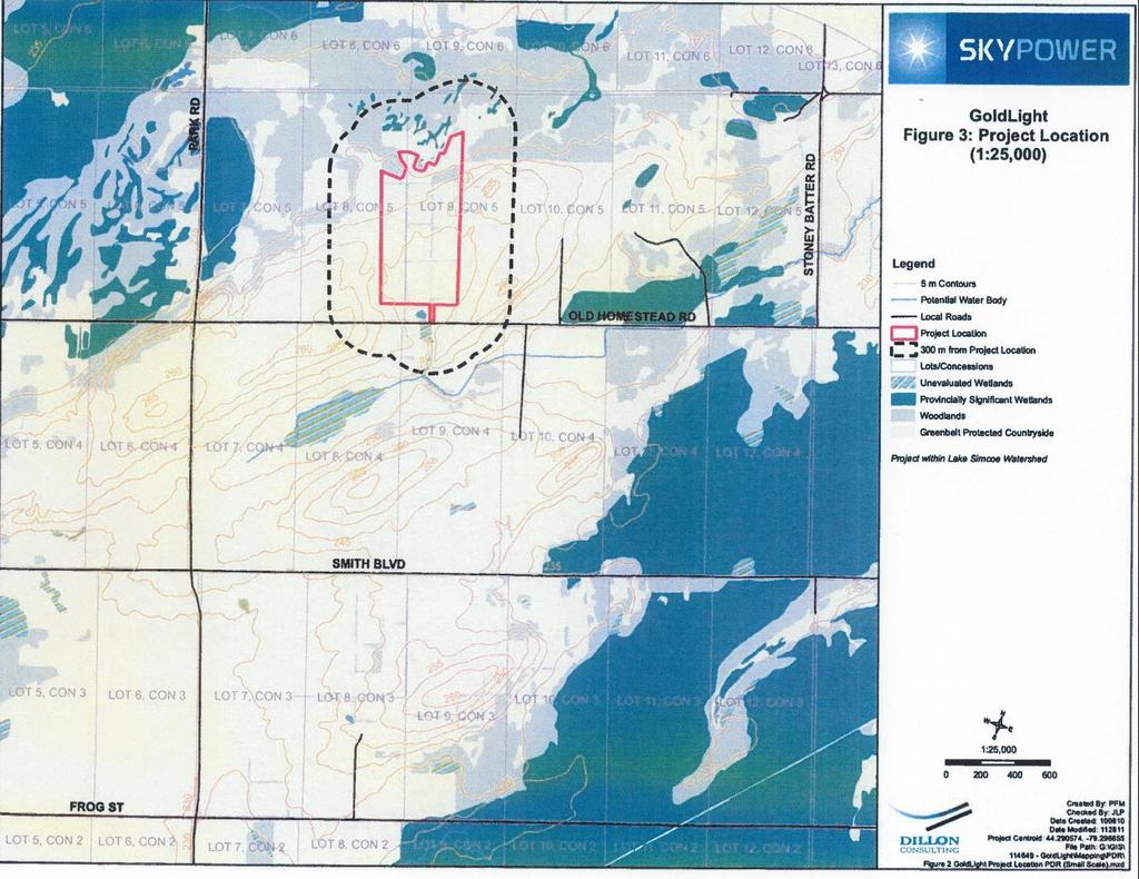
69 45
70
71 46
72

73 Map 5 Original Project Area 45
74

75 Map Tremaine Map of York (original scale 1:107,000) 46

76 Map Illustrated Historical Map Section 47

77 Map 8 Archaeological Potential Mapping 48
78
 (GOOGLE")
79 Map 9 Lake Algonquin Shoreline (arrows indicate area covered by water) (GOOGLE EARTH) 49
80
81 Map 10 Field Identification 50
82
83 Map 11 Photograph Locations 51
84

85 Map 12 Assessment Methodology 52
86
87 53
88

89 Map 14 Distribution of Scatter BbGt-29 54
90

91 Map 15 Distribution of Scatter BbGt-30 55
92

93 Map 16 Isolated Findspot 56
94

95 Map 17a Areas Requiring Stage 2 Archaeological Assessment 57

96 Map 17b Areas Requiring Stage 2 Archaeological Assessment 58
97 59 IILLUSTRATIONS/PHOTOGRAPHS Photograph 1 - Field A facing East Photograph 2 Field A, B and H facing North

98 60 Photograph 3 Field D facing Northeast Photograph 4 Field E facing West
99 61 Photograph 5 Field E facing Southeast Photograph 6 Field F facing Southwest
 Photograph 8 Field H facing")
100 62 Photograph 7 Field G facing East (ploughed in 2012) Photograph 8 Field H facing Northwest

101 63 Photograph 9 Field I facing South Photograph 10 Agricultural Roadway facing South

102 64 Photograph 11 Borrow Pit facing West Photograph 12 Field C and D facing North

103 Photograph 13 Reative Artifacts from BbGt-29 65

104 Photograph 14 Reative Sample from BbGt-29 66

105 Photograph 15 Reative Sample from BbGt-30 67

106 Photograph 16 Reative Sample from BbGt-30 68

107 Photograph 17 Reative Sample from BbGt-30 69

108 Photograph 18 Reative Sample from BbGt-30 70

109 Photograph 19 Reative Sample from BbGt-30 71

110 Photograph 20 Isolated Prehistoric Findspot 72
111 73 Appendix A Site Catalogue BbGt-29 WP WayPoint #, T - thickness Cat # Freq Material Type & Colour Function- Functional Category Glaze/ Surface Finish Decorative Tech Decorative Colour Manufacture Tech. Descriptive Notes (mm) 1 1 ceramic refined white Hollowware n/a undecorated n/a n/a ceramic refined white Hollowware n/a hand painted green n/a ceramic vitrified white Hollowware n/a undecorated n/a n/a ceramic vitrified white Hollowware n/a indeterminate blue n/a base sherd 5 1 ceramic vitrified white Indeterminate n/a moulded - n/a n/a Wheat Pattern 6 1 ceramic refined white Hollowware n/a undecorated n/a n/a Glass light aqua Flat n/a n/a n/a T: ceramic refined white Hollowware n/a undecorated n/a n/a base sherd ceramic refined white Indeterminate n/a undecorated n/a n/a ceramic refined white hollowware n/a undecorated n/a n/a ceramic vitrified white hollowware n/a moulded n/a n/a ceramic refined white indeterminate n/a undecorated n/a n/a ceramic refined white indeterminate n/a transfer - blue n/a Willow 14 1 ceramic refined white indeterminate n/a undecorated n/a n/a ceramic coarse red crockery grey undecorated n/a n/a ceramic porcelain hollowware n/a transfer brown n/a 17 3 ceramic refined white indeterminate n/a undecorated n/a n/a ceramic white ball clay pipe n/a undecorated n/a n/a Bowl sherd 19 1 ceramic refined white indeterminate n/a undecorated n/a n/a Dates Date Citations Jouppien 1980 OMCR Jouppien 1980 Sussman 1985 Jouppien 1980 Jouppien 1980 Jouppien 1980 Jouppien 1980 Jouppien 1980 Jouppien 1980 OMCR nd Jouppien 1980 Jouppien 1980 Jouppien 1980 Jouppien 1980 Jouppien 1980
112 74 Cat # Freq Material Type & Colour Function- Functional Category Glaze/ Surface Finish Decorative Tech Decorative Colour Manufacture Tech. Descriptive Notes (mm) Dates Date Citations 20 1 ceramic vitrified white hollowware n/a moulded - Wheat Pattern n/a n/a Sussman ceramic refined white indeterminate n/a undecorated n/a n/a Jouppien ceramic vitrified white flatware n/a moulded - Wheat Pattern n/a n/a Sussman ceramic vitrified white hollowware n/a undecorated n/a n/a Jouppien ceramic buffware crockery clear undecorated n/a n/a Ca.19t OMCR nd h C 25 1 ceramic refined white hollowware n/a restaurant green & n/a Conroy 1998 ware - banded red 26 1 Glass aqua container n/a n/a n/a 27 1 ceramic refined white hollowware n/a undecorated n/a n/a ceramic buffware crockery clear n/a n/a n/a Ca.19t h C 29 1 ceramic vitrified white hollowware n/a undecorated n/a n/a Late/ modern sparkles under glaze 30 1 ceramic refined white hollowware n/a stamped (cut red & blue n/a sponge) ceramic buffware crockery brown n/a n/a n/a Ca.19t h C 32 1 ceramic coarse red indeterminate unglazed n/a n/a n/a ceramic vitrified white hollowware n/a undecorated n/a n/a ceramic vitrified white hollowware n/a undecorated n/a n/a Glass black container n/a n/a n/a 36 1 ceramic refined white 37 1 ceramic refined white hollowware n/a undecorated n/a n/a indeterminate n/a undecorated n/a n/a Maker's Mark crown incomplete Jouppien 1980 OMCR nd Miller 1991 OMCR nd Jouppien 1980 Jouppien 1980 Jouppien 1980 Jouppien 1980 Jouppien ceramic refined white hollowware n/a undecorated n/a n/a Jouppien
113 75 Cat # Freq Material Type & Colour Function- Functional Category Glaze/ Surface Finish Decorative Tech Decorative Colour Manufacture Tech. Descriptive Notes (mm) ceramic vitrified white hollowware n/a undecorated n/a n/a ceramic vitrified white hollowware n/a moulded - n/a n/a Wheat Pattern 41 1 ceramic refined white hollowware n/a undecorated n/a n/a Glass colourless flat n/a n/a n/a T: Glass colourless flat n/a n/a n/a T: ceramic buffware crockery clear n/a n/a n/a Ca.19t h C 45 1 ceramic vitrified white hollowware n/a undecorated n/a Glass opaque white knob(?) n/a n/a n/a 2+part ca.185 mould 0s ceramic stoneware crockery clear n/a n/a n/a 48 1 ceramic coarse red crockery grey n/a n/a n/a Glass aqua container n/a paneled n/a mould blown 50 1 ceramic refined white 51 1 ceramic refined white 52 2 ceramic vitrified white 53 1 ceramic vitrified white 54 1 ceramic refined white 55 1 ceramic refined white 56 1 ceramic refined white 57 1 ceramic refined white 58 1 ceramic vitrified white Dates hollowware n/a transfer - Willow blue n/a hollowware n/a transfer blue n/a flatware n/a moulded - n/a n/a Wheat Pattern hollowware n/a moulded - n/a n/a Wheat Pattern hollowware n/a annular red n/a banding indeterminate n/a undecorated n/a n/a Maker's Mark - incomplete hollowware n/a undecorated n/a n/a hollowware n/a undecorated n/a n/a hollowware n/a undecorated n/a n/a Maker's Mark Date Citations Jouppien 1980 Sussman 1985 Jouppien 1980 OMCR nd Jouppien 1980 Jones & Sullivan 1985 Jouppien 1980 OMCR nd Jouppien 1980 Sussman 1985 Sussman 1985 Jouppien 1980 Jouppien 1980 Jouppien 1980 Jouppien 1980
114 76 Cat # Freq Material Type & Colour Function- Functional Category Glaze/ Surface Finish Decorative Tech Decorative Colour Manufacture Tech. Descriptive Notes (mm) {...LAND} 59 1 ceramic refined white indeterminate n/a undecorated n/a n/a ceramic vitrified white flatware n/a moulded - n/a n/a Wheat Pattern 61 1 ceramic vitrified white hollowware n/a undecorated n/a n/a ceramic stoneware inkwell clear/bro n/a n/a n/a wnish 63 1 ceramic refined white hollowware n/a transfer blue n/a ceramic refined white hollowware n/a indeterminate blue n/a 65 1 Glass colourless flat n/a n/a n/a T: ceramic refined white hollowware n/a stamped (cut sponge) red & blue n/a ceramic refined white hollowware n/a undecorated n/a n/a Metal indeterminate farm implement n/a n/a n/a n/a 69 1 Rock groundstone possible celt n/a n/a n/a n/a one ground end - broke 70 SCRAT CH 78? Dates Date Citations Jouppien 1980 Sussman 1985 Jouppien 1980 Jouppien 1980 Miller 1991 Jouppien 1980
115 77 Appendix B Site Catalogue BbGt-30 Cat # Freq Material Type & Colour Function- Functional Category Glaze /Surface Finish Decorative Tech Decorative Colour Manufacture Tech. 1 1 glass aqua Container n/a n/a n/a indeterminate Descriptive Notes (mm) 2 2 ceramic refined white indeterminate n/a undecorated n/a n/a glass colourless Flat n/a n/a n/a T: glass olive green Container n/a n/a n/a indeterminate heat altered 5 1 metal nail Structural n/a n/a n/a machine cut ceramic coarse red indeterminate unglazed n/a n/a n/a ceramic yellowware indeterminate n/a n/a n/a n/a ceramic refined white Hollowware n/a sponge blue n/a ceramic refined white Hollowware n/a dipt - annular blue n/a thC 10 1 ceramic refined white Hollowware n/a undecorated n/a n/a organic bone miscellaneous n/a n/a n/a n/a unmodified 12 2 ceramic refined white indeterminate n/a undecorated n/a n/a ceramic stoneware Crockery clear undecorated n/a n/a Dates Date Citations Nelson 1968 Maryland Archaeological Conservation Lab ceramic coarse red Crockery clear undecorated n/a n/a ceramic coarse red indeterminate unglazed n/a n/a n/a ceramic refined white indeterminate n/a undecorated n/a n/a ceramic yellowware indeterminate n/a undecorated n/a n/a ceramic refined white Hollowware n/a transfer blue n/a ceramic refined white indeterminate n/a undecorated n/a n/a ceramic refined white hollowware n/a undecorated n/a n/a 1820-
116 78 Cat # Freq Material Type & Colour Function- Functional Category Glaze /Surface Finish Decorative Tech Decorative Colour 21 2 metal scrap miscellaneous n/a n/a n/a n/a 22 4 ceramic refined white 23 1 ceramic refined white 24 1 ceramic refined white 25 1 ceramic refined white Manufacture Tech. Descriptive Notes (mm) Dates Hollowware n/a undecorated n/a n/a indeterminate n/a sponge blue n/a indeterminate n/a dipt - annular blue & n/a brown 20thC Hollowware n/a edge - unscalloped impressed blue n/a heat altered ceramic coarse red Crockery brown n/a n/a n/a rim sherd ceramic vitrified white Flatware n/a moulded edge n/a n/a 28 1 ceramic stoneware Crockery clear n/a n/a n/a 29 1 ceramic vitrified white Hollowware n/a undecorated n/a n/a glass black Container n/a n/a n/a indeterminate 31 1 ceramic refined white 32 1 ceramic vitrified white Hollowware n/a transfer blue n/a Hollowware n/a undecorated n/a n/a handle sherd 1870s- - cup 1880s 33 1 ceramic vitrified white Hollowware n/a undecorated n/a n/a ceramic vitrified white Flatware n/a undecorated n/a n/a ceramic stoneware - Crockery Albany undecorated n/a n/a buff composit plastic - blue indeterminate n/a n/a n/a e 37 1 ceramic refined white Hollowware n/a moulded n/a n/a handle sherd - cup 38 1 ceramic refined white indeterminate n/a undecorated n/a n/a Date Citations Maryland Archaeological Conservation Lab 2003 Miller 1987 Maryland Archaeological Conservation Lab 2003 Ramsey 1939
117 79 Cat # Freq Material Type & Colour Function- Functional Category Glaze /Surface Finish Decorative Tech Decorative Colour Manufacture Tech. Descriptive Notes (mm) 39 1 ceramic refined white Hollowware n/a hand painted green n/a ceramic refined white Hollowware n/a transfer blue n/a glass aqua indeterminate n/a n/a n/a indeterminate heat altered 42 3 ceramic refined white Hollowware n/a undecorated n/a n/a ceramic refined white Hollowware n/a sponge blue n/a ceramic refined white Hollowware n/a undecorated n/a n/a ceramic stoneware Crockery clear undecorated n/a n/a 46 3 ceramic refined white Hollowware n/a undecorated n/a n/a ceramic refined white Flatware n/a moulded edge n/a n/a 48 1 glass colourless Flat n/a n/a n/a n/a T: ceramic refined white 50 1 ceramic refined white 51 2 ceramic vitrified white 52 2 ceramic refined white 53 1 ceramic refined white 54 1 ceramic refined white 55 1 ceramic refined white 56 1 ceramic refined white 57 1 ceramic coarse red 58 1 ceramic vitrified white 59 2 ceramic refined white Dates Flatware n/a flow blue n/a n/a Flatware n/a transfer & green n/a floral moulded Hollowware n/a moulded edge n/a n/a indeterminate n/a undecorated n/a n/a indeterminate n/a transfer blue n/a indeterminate n/a undecorated n/a n/a indeterminate n/a edge - blue n/a unscalloped 1857 impressed Hollowware n/a transfer black n/a Crockery clear undecorated n/a n/a Flatware n/a undecorated n/a n/a heat altered; rim sherd indeterminate n/a undecorated n/a n/a Date Citations OMCR nd Miller 1987
118 80 Cat # Freq Material Type & Colour Function- Functional Category Glaze /Surface Finish Decorative Tech Decorative Colour Manufacture Tech glass opaque white indeterminate n/a n/a n/a indeterminate Descriptive Notes (mm) Dates Date Citations 61 1 ceramic refined white Hollowware n/a undecorated n/a n/a ceramic refined white Hollowware n/a sponge blue n/a glass aqua Container n/a n/a n/a 2+ part mould ca Jones & Sullivan ceramic vitrified white Hollowware n/a undecorated n/a n/a base sherds ceramic vitrified white Flatware n/a undecorated n/a n/a rim sherd ceramic refined white Hollowware n/a undecorated n/a n/a glass green club sauce type n/a n/a n/a stopper 68 1 ceramic refined white Hollowware n/a flow blue n/a n/a ceramic refined white Flatware n/a edge - blue n/a Miller 1987 unscalloped impressed ceramic refined white indeterminate n/a undecorated n/a n/a rim sherd ceramic refined white Hollowware n/a undecorated n/a n/a ceramic refined white indeterminate n/a undecorated n/a n/a ceramic coarse red indeterminate unglazed undecorated n/a n/a ceramic refined white Hollowware n/a transfer - Willow blue n/a OMCR nd 75 1 ceramic refined white Hollowware n/a dipt - annular brown n/a thC Maryland Archaeological Conservation Lab ceramic refined white indeterminate n/a moulded edge n/a n/a 77 1 glass light aqua safety glass n/a n/a n/a ca.1915 Panati glass black Container n/a n/a n/a indeterminate 79 1 glass opaque white indeterminate n/a n/a n/a indeterminate
119 81 Cat # Freq Material Type & Colour Function- Functional Category Glaze /Surface Finish Decorative Tech Decorative Colour Manufacture Tech. Descriptive Notes (mm) 80 1 ceramic refined white indeterminate n/a undecorated n/a n/a ceramic vitrified white Hollowware n/a undecorated n/a n/a base sherds ceramic refined white indeterminate n/a undecorated n/a n/a ceramic refined white indeterminate n/a undecorated n/a n/a ceramic coarse red Crockery brown undecorated n/a n/a Glass green, olive Container n/a n/a n/a indeterminate 86 3 ceramic refined white Hollowware n/a undecorated n/a n/a ceramic refined white Hollowware n/a undecorated n/a n/a glass aqua Flat n/a n/a n/a n/a T: ceramic vitrified white Hollowware n/a undecorated n/a n/a heat altered ceramic porcelain Hollowware n/a undecorated n/a n/a heat altered 91 2 ceramic refined white indeterminate n/a undecorated n/a n/a ceramic semiporcelain indeterminate n/a undecorated n/a n/a Maker's mark: {N} 93 1 glass aqua indeterminate n/a n/a n/a mould blown Dates Date Citations 94 1 ceramic buffware Crockery clear n/a n/a n/a Ca.19th OMCR nd C 95 1 ceramic vitrified white Hollowware n/a undecorated n/a n/a base sherd ceramic vitrified white Hollowware n/a ribbed n/a n/a ceramic vitrified white Hollowware n/a undecorated n/a n/a ceramic refined white Hollowware n/a moulded edge n/a n/a 99 1 ceramic yellowware Hollowware n/a undecorated n/a n/a ceramic coarse red Crockery brown undecorated n/a n/a ceramic coarse red indeterminate unglazed n/a n/a n/a 1796-
120 82 Cat # Freq Material Type & Colour Function- Functional Category Glaze /Surface Finish Decorative Tech Decorative Colour Manufacture Tech. Descriptive Notes (mm) ceramic white ball clay Pipe n/a undecorated n/a n/a bowl frag ceramic refined white indeterminate n/a edge - unscalloped blue n/a ceramic refined white indeterminate n/a undecorated n/a n/a ceramic coarse red indeterminate unglazed n/a n/a n/a ceramic refined white indeterminate n/a transfer blue n/a glass colourless Flat n/a n/a n/a T: ceramic refined white indeterminate n/a undecorated n/a n/a glass colourless indeterminate n/a n/a n/a indeterminate glass light aqua Flat n/a n/a n/a n/a T: ceramic coarse red Crockery clear n/a n/a n/a ceramic buffware Crockery clear n/a n/a n/a Ca.19th C ceramic coarse red indeterminate unglazed n/a n/a n/a ceramic refined white Flatware n/a undecorated n/a n/a glass light aqua Container n/a n/a n/a indeterminate ceramic refined white indeterminate n/a stamped (cut sponge) red n/a ceramic refined white Hollowware n/a transfer green n/a glass opaque white Hollowware n/a n/a n/a indeterminate ceramic coarse red ceramic refined white ceramic coarse red ceramic refined white Dates indeterminate unglazed n/a n/a n/a indeterminate n/a undecorated n/a n/a Crockery brown undecorated n/a n/a Hollowware n/a undecorated n/a n/a heat altered Date Citations Miller 1987 OMCR nd Miller 1991
121 83 Cat # Freq Material Type & Colour ceramic refined white ceramic coarse red ceramic refined white ceramic refined white ceramic refined white Function- Functional Category Glaze /Surface Finish Decorative Tech Decorative Colour Manufacture Tech. Descriptive Notes (mm) Dates indeterminate n/a undecorated n/a n/a heat altered Crockery clear undecorated n/a n/a indeterminate n/a hand painted late palette n/a Hollowware n/a stamped (cut red n/a sponge) 1930 indeterminate n/a edge - blue n/a unscalloped 1857 impressed Hollowware n/a undecorated n/a n/a ceramic refined white metal scrap miscellaneous n/a n/a n/a n/a ceramic refined white Hollowware n/a undecorated n/a n/a ceramic stoneware Crockery salt glaze undecorated n/a n/a ceramic refined white indeterminate n/a hand painted green n/a ceramic refined white indeterminate n/a hand painted late palette n/a ceramic refined white indeterminate n/a edge - blue n/a unscalloped ceramic coarse red indeterminate unglazed n/a n/a n/a ceramic refined white indeterminate n/a undecorated n/a n/a ceramic vitrified white indeterminate n/a undecorated n/a n/a ceramic refined white Hollowware n/a dipt blue n/a thC ceramic refined white ceramic refined white ceramic refined white indeterminate n/a undecorated n/a n/a Flatware n/a edge - blue n/a unscalloped 1857 impressed Hollowware n/a hand painted green n/a Date Citations OMCR nd Miller 1991 Miller 1987 OMCR nd OMCR nd Miller 1987 Maryland Archaeological Conservation Lab 2003 Miller 1987 OMCR nd
122 84 Cat # Freq Material Type & Colour Function- Functional Category Glaze /Surface Finish Decorative Tech Decorative Colour Manufacture Tech. Descriptive Notes (mm) ceramic white ball clay Pipe n/a moulded n/a n/a bowl sherd; vertical lines &? glass aqua indeterminate n/a n/a n/a indeterminate heat altered glass colourless indeterminate n/a n/a n/a Indeterminate heat altered ceramic refined white ceramic refined white Dates Hollowware n/a sponge red, green, purple n/a Hollowware n/a dipt - annular blue n/a thC Date Citations Maryland Archaeological Conservation Lab ceramic refined white indeterminate n/a undecorated n/a n/a ceramic refined white Hollowware n/a undecorated n/a n/a ceramic refined white Hollowware n/a sponge red, green n/a ceramic refined white Hollowware n/a transfer - Willow blue n/a OMCR nd ceramic refined white indeterminate n/a undecorated n/a n/a ceramic refined white Flatware n/a edge - blue n/a Miller 1987 unscalloped ceramic refined white Hollowware n/a undecorated n/a n/a ceramic vitrified white Hollowware n/a undecorated n/a n/a ceramic vitrified white indeterminate n/a undecorated n/a n/a ceramic refined white indeterminate n/a undecorated n/a n/a ceramic refined white indeterminate n/a transfer blue n/a ceramic refined white indeterminate n/a moulded - n/a n/a stippling ceramic refined white indeterminate n/a transfer green n/a ceramic vitrified white Flatware n/a restaurant ware brown n/a Conroy ceramic refined white flatware n/a undecorated n/a n/a 1820-
123 85 Cat # Freq Material Type & Colour Function- Functional Category Glaze /Surface Finish Decorative Tech Decorative Colour Manufacture Tech. Descriptive Notes (mm) ceramic refined white indeterminate n/a indeterminate red, green n/a glass light aqua Container n/a n/a n/a machine made ghost seam ceramic refined white indeterminate n/a undecorated n/a n/a ceramic refined white Flatware n/a transfer - Willow blue n/a glass green, olive Container n/a n/a n/a indeterminate ceramic vitrified white Flatware n/a moulded - Wheat Pattern n/a n/a ceramic refined white Flatware n/a undecorated n/a n/a ceramic vitrified white Hollowware n/a panelled n/a n/a ceramic refined white indeterminate n/a undecorated n/a n/a other rock - miscellaneous n/a n/a n/a n/a covered in sedimentary layer of melted green glass ceramic refined white indeterminate n/a undecorated n/a n/a ceramic vitrified white Flatware n/a undecorated n/a n/a glass aqua Container n/a n/a n/a indeterminate ceramic stoneware - buff ceramic refined white ceramic vitrified white ceramic refined white ceramic refined white ceramic vitrified white Crockery clear n/a n/a n/a Hollowware n/a banded -rim brown n/a Hollowware n/a moulded edge n/a n/a Dates Hollowware n/a undecorated n/a n/a Flatware n/a undecorated n/a n/a heat altered Flatware n/a decal - floral polychrom n/a e Date Citations Jones & Sullivan 1985 OMCR nd Sussman 1985 Stelle 2001
124 86 Cat # Freq Material Type & Colour Function- Functional Category Glaze /Surface Finish Decorative Tech Decorative Colour Manufacture Tech. Descriptive Notes (mm) organic bone miscellaneous n/a n/a n/a n/a unmodified ceramic refined white Flatware n/a edge - unscalloped blue n/a ceramic refined white indeterminate n/a edge - not blue n/a impressed ceramic refined white Hollowware n/a undecorated n/a n/a ceramic coarse red Crockery clear undecorated n/a n/a base sherd ceramic refined white indeterminate n/a undecorated n/a n/a ceramic refined white indeterminate n/a undecorated n/a n/a ceramic vitrified white Hollowware n/a ribbed n/a n/a glass black indeterminate n/a n/a n/a indeterminate Dates Date Citations Miller 1987 Miller ceramic refined white Flatware n/a transfer blue n/a ceramic refined white indeterminate n/a undecorated n/a n/a glass aqua Container n/a n/a n/a 2+ part mould vertical seam ca Jones & Sullivan glass solarized indeterminate n/a n/a n/a indeterminate ca Jones & Sullivan ceramic refined white indeterminate n/a undecorated n/a n/a ceramic vitrified white Hollowware n/a moulded edge n/a n/a glass colourless Flat n/a n/a n/a n/a T: ceramic refined white Hollowware n/a dipt - annular blue n/a thC ceramic refined white indeterminate n/a undecorated n/a n/a glass colourless Flat n/a n/a n/a n/a T:1.5 Maryland Archaeological Conservation Lab ceramic refined white Hollowware n/a undecorated n/a n/a ceramic refined white indeterminate n/a edge - blue n/a Miller 1987
125 87 Cat # Freq Material Type & Colour ceramic refined white ceramic refined white ceramic refined white ceramic refined white ceramic refined white ceramic refined white Function- Functional Category Glaze /Surface Finish Decorative Tech Decorative Colour Manufacture Tech. Descriptive Notes (mm) Dates unscalloped 1857 impressed Hollowware n/a undecorated n/a n/a Hollowware n/a undecorated n/a n/a Hollowware n/a hand painted green n/a indeterminate n/a moulded edge n/a n/a Hollowware n/a dipt - annular blue n/a thC indeterminate n/a edge - unscalloped impressed blue n/a ceramic coarse red Crockery brown n/a n/a n/a ceramic coarse red indeterminate unglazed n/a n/a n/a ceramic refined white indeterminate n/a transfer blue n/a ceramic refined white indeterminate n/a undecorated n/a n/a heat altered glass solarized Container n/a n/a n/a 2+ part mould ca ceramic refined white Hollowware n/a indeterminate blue n/a heat altered ceramic vitrified white Hollowware n/a moulded -sprigs n/a n/a 1850s (Foliage) 1860s ceramic refined white indeterminate n/a edge - unscalloped, not impressed blue n/a Date Citations OMCR nd Maryland Archaeological Conservation Lab 2003 Miller 1987 Jones & Sullivan 1985 Maryland Archaeological Conservation Lab 2003 Miller glass colourless, Container n/a fluted n/a n/a frosted ceramic refined white Hollowware n/a hand painted late palette n/a heat altered OMCR nd ceramic coarse red crockery clear n/a n/a n/a 1796-
126 88 Cat # Freq Material Type & Colour Function- Functional Category Glaze /Surface Finish Decorative Tech Decorative Colour Manufacture Tech. Descriptive Notes (mm) glass solarized Container n/a embossed n/a mould blown embossed w. {HIA) glass opaque white Tableware n/a n/a n/a base sherd - donut shaped glass light aqua Flat n/a n/a n/a T:1.3; glass black Container n/a n/a n/a indeterminate Dates ceramic vitrified white Hollowware n/a moulded - Wheat Pattern n/a n/a ceramic coarse red Crockery grey undecorated n/a n/a ceramic vitrified white Flatware n/a undecorated n/a n/a rim sherd ceramic refined white indeterminate n/a undecorated n/a n/a glass light aqua Flat n/a n/a n/a T:2.4 ca ceramic refined white indeterminate n/a undecorated n/a n/a glass opaque white indeterminate n/a n/a n/a ceramic refined white ceramic refined white indeterminate n/a undecorated n/a n/a Flatware n/a edge - unscalloped, not impressed blue n/a Date Citations Sussman 1985 Jones & Sullivan 1985 Miller ceramic white ball clay Pipe n/a undecorated n/a n/a stem sherd ceramic refined white Hollowware n/a hand painted green n/a OMCR nd ceramic refined white Hollowware n/a sponge blue n/a ceramic refined white indeterminate n/a undecorated n/a n/a ceramic refined white indeterminate n/a undecorated n/a n/a ceramic white ball clay Pipe n/a undecorated n/a n/a stem sherd ceramic refined white indeterminate n/a transfer - Willow blue n/a OMCR nd ceramic refined white hollowware n/a edge - blue n/a Miller 1987
127 89 Cat # Freq Material Type & Colour Function- Functional Category Glaze /Surface Finish Decorative Tech Decorative Colour Manufacture Tech. Descriptive Notes (mm) unscalloped ceramic refined white Hollowware n/a undecorated n/a n/a ceramic coarse red indeterminate unglazed undecorated n/a n/a ceramic refined white Hollowware n/a transfer - Willow blue n/a ceramic refined white indeterminate n/a undecorated n/a n/a glass light green Container n/a n/a n/a ceramic refined white ceramic vitrified white ceramic refined white ceramic refined white ceramic refined white ceramic vitrified white ceramic vitrified white ceramic refined white ceramic refined white ceramic refined white ceramic vitrified white ceramic refined white ceramic refined white Dates Flatware n/a transfer green n/a Flatware n/a undecorated n/a n/a indeterminate n/a edge - blue n/a unscalloped 1884 indeterminate n/a undecorated n/a n/a indeterminate n/a indeterminate blue n/a Hollowware n/a undecorated n/a n/a Hollowware n/a undecorated n/a n/a heat altered Hollowware n/a hand painted green n/a Hollowware n/a dipt - annular blue n/a thC Hollowware n/a transfer blue n/a Hollowware n/a undecorated n/a n/a handle sherd 1870s- - cup 1880s indeterminate n/a undecorated n/a n/a Hollowware n/a flow blue n/a n/a Date Citations OMCR nd Miller 1987 OMCR nd Maryland Archaeological Conservation Lab 2003 Maryland Archaeological Conservation Lab 2003
128 90 Cat # Freq Material Type & Colour Function- Functional Category Glaze /Surface Finish Decorative Tech Decorative Colour Manufacture Tech glass light green Container n/a n/a n/a indeterminate Descriptive Notes (mm) ceramic refined white Hollowware n/a hand painted late palette n/a ceramic refined white indeterminate n/a edge - impressed blue n/a ceramic refined white Hollowware n/a transfer green n/a ceramic vitrified white Flatware n/a undecorated n/a n/a rim sherd ceramic coarse red Crockery clear undecorated n/a n/a ceramic vitrified white Hollowware n/a undecorated n/a n/a ceramic porcelain toy doll's leg n/a hand painted n/a n/a ceramic vitrified white Flatware n/a undecorated n/a n/a ceramic vitrified white Hollowware n/a undecorated n/a n/a rim sherd glass light aqua Container n/a n/a n/a indeterminate glass light aqua Flat n/a n/a n/a T:2.0; glass light aqua Vial n/a n/a n/a 2+ part mould w. hand finish ca ceramic refined white indeterminate n/a transfer blue n/a ceramic refined white Hollowware n/a edge - blue n/a unscalloped ceramic refined white Hollowware n/a undecorated n/a n/a ceramic porcelain indeterminate n/a undecorated n/a n/a ceramic refined white Hollowware n/a undecorated n/a n/a ceramic porcelain Hollowware n/a decal - floral polychrom n/a e ceramic vitrified white Hollowware n/a undecorated n/a n/a ceramic vitrified white Flatware n/a moulded edge - n/a n/a indeterminate ceramic refined white Hollowware n/a transfer brown n/a Dates Date Citations OMCR nd Miller 1987 Jones & Sullivan 1985 Miller 1987 Stelle 2001
129 91 Cat # Freq Material Type & Colour ceramic refined white ceramic refined white ceramic vitrified white ceramic refined white ceramic refined white Function- Functional Category Glaze /Surface Finish Decorative Tech Decorative Colour Manufacture Tech. Descriptive Notes (mm) Dates indeterminate n/a undecorated n/a n/a indeterminate n/a edge - blue n/a unscalloped 1884 Hollowware n/a undecorated n/a n/a handle sherd 1870s- - cup 1880s Hollowware n/a hand painted late palette n/a Flatware n/a edge - blue n/a unscalloped, not 1884 impressed Hollowware n/a undecorated n/a n/a ceramic refined white glass colourless Container n/a n/a n/a indeterminate Date Citations Miller 1987 Maryland Archaeological Conservation Lab 2003 OMCR nd Miller ceramic refined white Hollowware n/a indeterminate blue n/a ceramic stoneware - Crockery Rockingha undecorated n/a n/a buff m ceramic vitrified white Hollowware n/a undecorated n/a n/a rim sherd glass solarized Bottle n/a n/a n/a 2+ part mould ca Jones & Sullivan ceramic stoneware - Crockery Albany n/a n/a n/a Ramsey 1939 buff ceramic vitrified white indeterminate n/a moulded - Wheat n/a n/a Sussman 1985 Pattern ceramic stoneware Crockery clear undecorated n/a n/a glass light aqua Flat n/a n/a n/a n/a T: ceramic refined white ceramic refined white Hollowware n/a undecorated n/a n/a Flatware n/a edge - blue n/a unscalloped, not 1884 impressed Miller ceramic refined white Hollowware n/a dipt - annular brown, yellow n/a thC Maryland Archaeological Conservation Lab ceramic refined white indeterminate n/a undecorated n/a n/a 1820-
130 92 Cat # Freq Material Type & Colour Function- Functional Category Glaze /Surface Finish Decorative Tech Decorative Colour Manufacture Tech. Descriptive Notes (mm) Dates Date Citations 365 Appendix C Isolated Findspot Locational Data Isolated Findspot, WayPoint #864, 243m asl, 17T , Appendix D Locational Information for BbGt-29 Findspot # Cat. No. (s) Waypoint # UTM Coordinates 17T , , , , , 60, , , , , , , 64, , , , , , , , , 39, , , , , ,
131 93 Findspot # Cat. No. (s) Waypoint # UTM Coordinates 17T 16 17, , , , , , , , , , 48, 49, 50, , , , 15, , , , , , , 2, , , 54, 55, , , , , 5, 6, , , 31, , , , , , ,
132 94 Appendix E Locational Data for BbGt-30 Findspot # Cat. No. (s) WayPoint # UTM Coordinates 17T , SCRATCH , , , , , , , , , , , , , , , , , , , , , , , 79, , , , , , , , ,
133 95 Findspot # Cat. No. (s) WayPoint # UTM Coordinates 17T , , , , , , , , , , , , 239, , , , 211, , , 42, , , , , 123, 124, 125, 126, , , 153, , , 12, , , , , , 100, 101, 102, 103, , , , , 73, 74, , , , , 183, 184, , , 131, 132, 133, , , , , 233, 234, , , 254, 255, , , 271, 272, , ,
134 96 Findspot # Cat. No. (s) WayPoint # UTM Coordinates 17T 55 22, 23, 24, , , 38, 39, , , , , , , 120, , , 190, , , , 198, , , , , , , , 9, , , 249, 250, 251, , , 284, 285, , , 145, 146, , , 179, 180, , , , , , 58, , , 3, 4, 5, 6, , , , , SCRATCH , , , , 136, , , ,
135 97 Findspot # Cat. No. (s) WayPoint # UTM Coordinates 17T , , , , , , , , , , , , , , , , , SCRATCH , , , , , , , , , 89, 90, 91, 92, , , , , , , , 221, 222, 223, , , 170, , , 109, , , 292, 293, , , , ,
136 98 Findspot # Cat. No. (s) WayPoint # UTM Coordinates 17T , 50, 51, , , 175, 176, , , 167, , , 288, 289, , , , , 32, 33, , , 156, , , , , , , 64, , , 278, , , , 194, , , 245, , , 159, , , 264, , , , , , 267, 268, 269, , , , , , , ,

137 Stage 1 and 2 Archaeological Assessment for SkyPower GoldLight LP Solar Project, Part of Lot 8 and 9, Concession 5, Town of Georgina, Regional Municipality of York, Ontario FIT Reference # - F SPV Prepared by Licensee: George Clark Archaeological Consulting Licence P120 Project Information Number P THE ARCHAEOLOGISTS INC. Original Report May 8, 2012
138
139 Stage 1 and 2 Archaeological Assessment for SkyPower GoldLight LP Solar Project, Part of Lots 8 & 9, Concession 5, Town of Georgina, RM of York, Ontario EXECUTIVE SUMMARY The Archaeologists Inc. was contracted by SkyPower to conduct a Stage 1 and 2 archaeological assessment for the Goldlight LP Solar Project, Part of Lots 8 and 9, Concessions 5, in the Town of Georgina, Regional Municipality of York, Ontario. The proponent is seeking a Renewable energy Approval according to Ontario Regulation 359/09 issued under the Environmental Protection act, Sections 20, 21 and 22. The assessment was done in advance of a solar farm project. A Stage 1 background study of the subject property was conducted to provide information about the property s geography, history, previous archaeological fieldwork and current land condition in order to evaluate and document in detail the property s archaeological potential and to recommend appropriate strategies for Stage 2 survey. A Stage 2 property assessment was conducted to document all archaeological resources on the property, to determine whether the property contains archaeological resources requiring further assessment, and to recommend next steps. The characteristics of the property dictated that the Stage 2 survey be conducted by a pedestrian and test pit survey. The Stage 1 background study found that the subject property exhibits potential for the recovery of archaeological resources of cultural heritage value and concluded that the property requires a Stage 2 assessment. The Stage 2 property assessment, which consisted of a systematic pedestrian and test pit survey, did not result in the identification of archaeological resources. The Stage 1 background study concluded that the property exhibits archaeological potential. The Stage 2 property assessment did not identify any archaeological resources within the subject property. The report recommends that no further archaeological assessment of the subject property is required. i
140
141 Stage 1 and 2 Archaeological Assessment for SkyPower GoldLight LP Solar Project, Part of Lots 8 & 9, Concession 5, Town of Georgina, RM of York, Ontario TABLE OF CONTENTS Executive Summary i Table of Contents ii Project Personnel iii 1.0 Project Context Development Context 1.2 Historical Context 1.3 Archaeological Context Field Methods Record of Finds Analysis and Conclusions Recommendations Advice on Compliance with Legislation Bibliography and Sources Images Maps 17 ii
142
143 Stage 1 and 2 Archaeological Assessment for SkyPower GoldLight LP Solar Project, Part of Lots 8 & 9, Concession 5, Town of Georgina, RM of York, Ontario PROJECT PERSONNEL Project Director: Field Director: Field Archaeologists Report Preparation: Graphics Mr. T. Keith Powers (P052) Mr. Norbert Stanchly (R149) Mr. George Clark (P120) Mr. Misha Stecyk Mr. T. Keith Powers Mrs. Karen Powers Mr. Norbert Stanchly (R149) Mrs. Karen Powers Mr. T. Keith Powers iii
144
145 Stage 1 and 2 Archaeological Assessment for SkyPower GoldLight LP Solar Project, Part of Lots 8 & 9, Concession 5, Town of Georgina, RM of York, Ontario INTRODUCTION The Ontario Heritage Act, R.S.O c. O.18, requires anyone wishing to carry out archaeological fieldwork in Ontario to have a license from the Ministry of Tourism and Culture (MTC). All licensees are to file a report with the MTC containing details of the fieldwork that has been done for each project. Following standards and guidelines set out by the MTC is a condition of a licence to conduct archaeological fieldwork in Ontario. The Archaeologists Inc. confirms that this report meets ministry report requirements as set out in the 2011 Standards and Guidelines for Consultant Archaeologists, and is filed in fulfillment of the terms and conditions an archaeological license. 1.0 PROJECT CONTEXT (Section 7.5.5) This section of the report will provide the context for the archaeological fieldwork, including the development, historical and archaeological context. 1.1 Development Context (Section 7.5.6, Standards 1-3) Section 7.5.6, Standard 1 The Archaeologists Inc. was contracted to complete a Stage 1 and 2 archaeological assessment for the GoldLight LP Solar Project, located within Part of Lots 8 and 9, Concession 5, in the Town of Georgina, Regional Municipality of York, Ontario. The subject property consists of two separate parcels of land that comprise part of a larger subject area that had undergone a partial assessment in 2011 by Scarlett Janusas Archaeological Heritage Consulting and Education (SJAHCE) under PIF P Both parcels are located north of Old Homestead Road. The two parcels comprise an area of approximately 16.5 hectares in size. GoldLight LP proposes to develop a solar facility with a maximum name plate capacity of approximately 10 MW, located near Pefferlaw, in the Town of Georgina, Ontario. The renewable energy facility will be known as GoldLight LP and will be rated as a Class 3 solar facility. The characteristics of a Class 3 Solar Facility, as described in the regulation, are as follows: The location of solar photovoltaic collector panels and devices are at any location other than mounted on the roof or wall of a building. The name plate capacity of the solar facility is greater than 12 kilowatts. GoldLight LP has received a contract from the Ontario Power Authority (OPA) for the sale of electricity generated by this renewable facility through the Province s Feed-in- Tariff (FIT) program (enabled by the Green Energy and Green Economy Act). Approximately 30,000 to 100,000 PV panels of between watts each will be installed for GoldLight LP. The panels will be aligned in rows approximately 4-10 metres apart and will be mounted on racking systems will be attached to a support structure. 1
146 Stage 1 and 2 Archaeological Assessment for SkyPower GoldLight LP Solar Project, Part of Lots 8 & 9, Concession 5, Town of Georgina, RM of York, Ontario The project is seeking a Renewable Energy Approval according to Ontario Regulation 359/09 issued under the Environmental Protection Act, Sections 20, 21 and 22. The project has been awarded Feed-in-Tariff (FIT) contract number F SPV The portion of the project area subject to archaeological assessment by The Archaeologists Inc. is approximately 16.5 ha in size. The archaeological assessment was conducted in advance of the development as a condition of the above O. Reg. Section 7.5.6, Standard 2 There is no additional development-related information relevant to understanding the choice of fieldwork strategy or recommendations made in the report. Section 7.5.6, Standard 3 Permission to access the study area to conduct all required archaeological fieldwork activities, including the recovery of artifacts was given by the landowner and their reative. 1.2 Historical Context (Section 7.5.7, Standards 1-2) Section 7.5.7, Standard 1 In advance of the Stage 2 assessment, a Stage 1 background study of the subject property was conducted in order to document the property archaeological and land use history and condition. Several sources were referenced to determine if features or characteristics indicating archaeological potential for pre-contact and post-contact resources exist. Characteristics indicating archaeological potential include the near-by presence of previously identified archaeological sites, primary and secondary water sources, features indicating past water sources, accessible or inaccessible shoreline, pockets of welldrained sandy soil, distinctive land formations that might have been special or spiritual places, such as waterfalls, rock outcrops, caverns, mounds, and promontories and their bases, resource areas, (including food or medicinal plants, scarce raw materials, early Euro-Canadian industry), areas of early Euro-Canadian settlement, early historical transportation routes, property listed on a municipal register or designated under the Ontario Heritage Act or that is a federal, provincial or municipal historic landmark or site, and property that local histories or informants have identified with possible archaeological sites, historical events, activities, or occupations. Archaeological potential can be determined not to be for either the entire property or a part of it when the area under consideration has been subject to extensive and deep land alterations that have severely damaged the integrity of any archaeological resources. This is commonly referred to as disturbed or disturbance, and may include: quarrying, major landscaping involving grading below topsoil, building footprints, and sewage and infrastructure development. Archaeological potential is not removed where there is documented potential for deeply buried intact archaeological resources beneath land alterations, or where it cannot be clearly demonstrated through background research and property inspection that there has been complete and intensive disturbance of an area. 2
147 Stage 1 and 2 Archaeological Assessment for SkyPower GoldLight LP Solar Project, Part of Lots 8 & 9, Concession 5, Town of Georgina, RM of York, Ontario Where complete disturbance cannot be demonstrated in Stage 1, it will be necessary to undertake Stage 2 assessment. The background study determined that the following features or characteristics indicate archaeological potential for the subject property. The subject property is within 300 metres of a primary and secondary body of water. The subject property is within the Black River watershed. There is an unnamed tributary located approximately 125 metres southeast of the subject property. The presence of these would have been attractive areas for hunting or settlement for both precontact populations and European settlers. There are two known archaeological sites, BbGt-29 and BbGt-30, within 300 metres of the subject property. The subject property contains a past water source, i.e. an ancient shoreline associated with Lake Algonquian lies within the northern portion of the subject property. The subject property lies within the Lake Simcoe Basin in the Simcoe Lowlands physiographic region and is characterized as an area of low wet sand plains. The subject property has topographic features (e.g. knolls, drumlins) exhibiting potential. Soils consist of Otonabee loam, Emily loam, Granby loam, and Sargent sandy loam which exhibit variable drainage. The presence of sandy soils within the subject property adjacent to wet lowland areas would have attracted both precontact and historic settlement. The 1878 Illustrated Historical Atlas of the County of York depicts a structure within the subject property. The subject property is within 100 metres of an historic transportation routes, i.e. Old Homestead Road. Archaeological sites BbGt-29 and BbGt-30 were discovered in 2011 by Scarlett Janusas (SJAHCE 2012) during a Stage 2 pedestrian survey of lands immediately adjacent to the current subject property. Site BbGt-29 is a Euro-Canadian historic farmstead, and consists of a scatter of approximately 78 early to late 19 th century artifacts. It was interpreted to likely re the original farmstead in the area (SJAHCE 2012). Site BbGt-30 is a Euro-Canadian historic farmstead, and consists of a wide scatter of 365 early to late 19 th century artifacts. The nature of the site is unknown and may re the original historic farm/homestead depicted on the 1878 Atlas (SJAHCE 2012:19). The study area is located within part of Lots 8 and 9, Concession 5, in the former historical Township of Georgina, County of York. According to the 1878 Illustrated Historical Atlas of the County of York, Lot 9 was owned by a Jas. Leith and the portions of Lot 8 within the subject property were owned by a Joseph Cockburn and Jonathan Yates. The Atlas depicts a single structure within the subject property. It should be noted, however, that not all features of interest were mapped systematically in the Ontario series of historical atlases, given that they were financed by subscription, and subscribers were given preference with regard to the level of detail provided on the maps. Moreover, not every feature of interest would have been within the scope of the atlases. 3
148 Stage 1 and 2 Archaeological Assessment for SkyPower GoldLight LP Solar Project, Part of Lots 8 & 9, Concession 5, Town of Georgina, RM of York, Ontario A detailed land use history of the Lots 8 & 9, Concession 5, is provided in the archaeological assessment report entitled Stage 1 and 2 Archaeological Assessment, GoldLight Solar Farm, prepared by Scarlett Janusas Archaeological and Heritage Consulting and Education (SJAHCE 2012). Her report (SJAHCE 2012:6) states the following: Tremaine s map of the County of York, shows that both lots were occupied by Lot 8 was divided between three men, and, the study property lies on the properties occupied by J. Yates on the south and Thomas A. Odlam to the north. The west half of Lot 9 was occupied by John Cockburn and James Cockburn. In 1878 John Yates still occupies the south half of Lot 8, and there is a structure located towards the south side. In the 1871 census he is listed as Irish, born in Ontario and is 35 years of age. He belongs to the Church of England, and is a blacksmith. There is no one listed as occupying the south half of lot 8 in The west half of lot 9 is occupied by James Leith, a 50 year old Scottish farmer belonging to the Canadian Presbyterian Church. On his property are 2 structures. The first is located on the east half towards the south side of the property and the other on the west, towards the centre of the property. In summary, the Stage 1 background study indicated the potential for the recovery of precontact Indigenous and post-contact Euro-Canadian archaeological resources within the subject property. As it cannot be clearly demonstrated through the background study that there has been complete and intensive disturbance of the area, archaeological potential is not removed. There are areas within the subject property that have the potential for the recovery of archaeological resources. Section 7.5.7, Standard 2 The lands are agricultural and the Stage 2 property assessment of the subject property will employ the strategy of pedestrian and test pit survey, following the standards listed in Section and of the 2011 Standards and Guidelines for Consultant Archaeologists. To our knowledge there is a single report, prepared by Scarlett Janusas Archaeological and Heritage Consulting and Education (PIF P ) in 2012, containing relevant background information and recommendations related to this development project. The report indicates that the lands subject to archaeological assessment immediately adjacent to those completed and reported on in this report, were ploughable lands and recommends that: Stage 2 archaeological assessment is recommended for those areas not assessed by SJAHCE. 1.3 Archaeological Context (Section 7.5.8, Standards 1-7) Section 7.5.8, Standard 1 In order that an inventory of archaeological resources could be compiled for the study area, three sources of information were consulted: the site forms for registered sites 4
149 Stage 1 and 2 Archaeological Assessment for SkyPower GoldLight LP Solar Project, Part of Lots 8 & 9, Concession 5, Town of Georgina, RM of York, Ontario housed at the Ministry of Tourism and Culture; published and unpublished documentary sources; and the files of The Archaeologists Inc. In Ontario, information concerning archaeological sites is stored in the Ontario Archaeological Sites Database (O.A.S.D.), an inventory of the documented archaeological record in Ontario. Information on the known archaeological sites in the vicinity of the study area was obtained form the Ministry of Tourism and Culture site database. There are no known archaeological sites located within the study area limits and no sites were registered within a one kilometre radius of the subject property. Section 7.5.8, Standard 2 The study land is currently being used as agricultural land, pasture, and has existing scrub and woodlot areas. The subject property assessed by The Archaeologists Inc. consists of ploughed agricultural lands, hedgerows, a channelized ditch and a laneway or agricultural roadway (SJAHCE 2012). The property consists of undulating terrain. The northern portion of the property was formerly glacial strandline and consists of a very rocky-tilled substrate. The study area lies within the Lake Simcoe Basin of the Simcoe Lowlands physiographic region (Chapman and Putnam 1984: ). The lowlands bordering Georgian Bay and Lake Simcoe may be termed the Simcoe lowlands. Together they cover an area of about 1,100 square miles. They fall naturally into two major divisions separated by the uplands of Simcoe County. To the west are the plains draining into Nottawasaga Bay mostly by way of the Nottawasaga River. This area is called the Nottawasaga basin. To the east is the lowland surrounding Lake Simcoe, referred to as the Lake Simcoe basin. These two basins are connected at Barrie by a flat-floored valley and by similar valleys among the upland plateaux farther north. Both the lowlands and transverse valleys were flooded by Lake Algonquin and are bordered by shorecliffs, beaches, and bouldery terraces. Thus they are floored by sand, silt, and clay. The study area is on Trenton-Black River bedrock which is a limestone and dolostone formation. There is an unnamed creek to the southeast of the subject property. A glacial Lake Algonquian shoreline bisects the northern portion of the property. The soils are characterized by mainly well drained Otonabee loam. Also within the property are Emily, Sargent and Granby loams. The latter two are sandy soils with good drainage (Hoffman and Richards 1955). Section 7.5.8, Standard 3 The Stage 2 archaeological fieldwork of the subject property was undertaken April 24 and 25,
150 Stage 1 and 2 Archaeological Assessment for SkyPower GoldLight LP Solar Project, Part of Lots 8 & 9, Concession 5, Town of Georgina, RM of York, Ontario Section 7.5.8, Standard 4 Previous archaeological fieldwork was conducted adjacent to the current subject property. A Stage 1 and 2 archaeological assessment was conducted in 2011 immediately southeast of the current subject property by Scarlett Janusas Archaeological and Heritage Consulting and Education (SJAHCE 2012). The fieldwork was conducted in 2011 on a portion of the subject property measuring approximately 23.8 ha. Fieldwork involved a pedestrian survey of the lands. The fieldwork resulted in the identification of two historic archaeological sites, BbGt-29 and BbGt-30. An isolated flake was also identified. Site BbGt-29 is a Euro-Canadian historic farmstead, and consists of a scatter of approximately 78 early to late 19 th century artifacts. It was interpreted to likely re the original farmstead in the area (SJAHCE 2012). Site BbGt-30 is a Euro-Canadian historic farmstead, and consists of a wide scatter of 365 early to late 19 th century artifacts. The nature of the site is unknown and may re the original historic farm/homestead depicted on the 1878 Atlas (SJAHCE 2012:19). The report recommends that Sites BbGt-20 and BbGt-30 be subject to a Stage 3 site-specific assessment and that the isolated findspot is of no further archaeological concern. With the exception of this work, The Archaeologists Inc. is unaware of any previous archaeological fieldwork carried out immediately adjacent to the project area. Section 7.5.8, Standard 5 We are unaware of previous findings and recommendations relevant to the current stage of work, with the exception of the recommendations made by Scarlett Janusas in her Stage 1 and 2 archaeological assessment report which are discussed above. Section 7.5.8, Standard 6 There are no unusual physical features that may have affected fieldwork strategy decisions or the identification of artifacts or cultural features. Section 7.5.8, Standard 7 There is no additional archaeological information that may be relevant to understanding the choice of fieldwork techniques or the recommendations of this report. 6
151 Stage 1 and 2 Archaeological Assessment for SkyPower GoldLight LP Solar Project, Part of Lots 8 & 9, Concession 5, Town of Georgina, RM of York, Ontario 2.0 FIELD METHODS (Section 7.8.1, Standards 1-3) This section of the report addresses Section of the 2011 Standards and Guidelines for Consultant Archaeologists. It does not address Section because no property inspection was done as a separate Stage 1. Section 7.8.1, Standard 1 All of the subject property was assessed and surveyed. Section 7.8.1, Standard 2 As relevant, we provide detailed and explicit descriptions addressing Standards 2a and 2b. Section 7.8.1, Standard 2a - The general standards for property survey under Section 2.1 of the 2011 Standards and Guidelines for Consultant Archaeologists were addressed as follows: Section 2.1, S1 All of those portions of the property exhibiting archaeological potential were surveyed including lands immediately adjacent to built structures, when. Section 2.1, S2a There are no lands identified as no or low potential due to physical features such as permanently wet areas, within our subject property, with the exception of a channelized ditch and its associated low and wet area. Section 2.1, S2b There are no areas of no or low potential due to extensive and deep land alterations within our subject property, with the exception of the channelized ditch. Section 2.1, S2c (lands recommended not to require Stage 2 assessment by a previous Stage 1 report where the ministry has accepted that Stage 1 into the register) - n/a Section 2.1, S2d (lands designated for forest management activity w/o potential for impacts to archaeological sites, as determined through Stage 1 forest management plans process) - n/a Section 2.1, S2e (lands formally prohibited from alterations) - n/a Section 2.1, S2f ( lands confirmed to be transferred to a public land holding body, etc) - n/a Section 2.1, S3 - The Stage 2 survey was conducted when weather and lighting conditions permitted excellent visibility of features. Section 2.1, S4 - No GPS recordings were taken as no artifacts were found during the Stage 2 assessment. There were also no fixed landmarks. Section 2.1, S5 - All field activities were mapped in reference to survey stakes and development markers as appropriate. See report section 9.0 Maps. Section 2.1, S6 - See report section 8.0 Images for photo documentation of examples of field conditions encountered. 7
152 Stage 1 and 2 Archaeological Assessment for SkyPower GoldLight LP Solar Project, Part of Lots 8 & 9, Concession 5, Town of Georgina, RM of York, Ontario Section 2.1, S7 No heavy machinery was used. Section 7.8.1, Standard 2b -The subject property was subject to a systematic pedestrian survey appropriate to the characteristics of the property. Section 2.1.1, S1 Actively or recently cultivated agricultural land was subject to pedestrian survey. Section 2.1.1, S2 Lands were recently ploughed. Section 2.1.1, S3 Ploughed lands were weathered by at least one heavy rainfall or several light rains to improve the visibility of archaeological resources. Section 2.1.1, S4 No direction was provided to the contractor undertaking the ploughing by The Archaeologists Inc., as we were contracted to complete the project after ploughing had been completed. Section 2.1.1, S5 At least 80% of the ploughed ground surface was visible. Section 2.1.1, S6 Survey transects were spaced at maximum intervals of 5 metres. Section 2.1.1, S7 - n/a Section 2.1, S8 n/a Section 2.1, S9 n/a Section 7.8.1, Standard 2b -The subject property was subject to a systematic test pit survey appropriate to the characteristics of the property. Section 2.1.2, S1 Test pit survey was only conducted on terrain where ploughing was not possible or viable. This included a narrow farm laneway measuring between 4-7 metres in width. Section 2.1.2, S2 A single north-south row of test pits were spaced at maximum 5 metre intervals in the laneway as it was within 300 metres of features of archaeological potential. Section 2.1.2, S3 n/a Section 2.1.2, S4 n/a Section 2.1.2, S5 All test pits were at least 30 cm in diameter. Section 2.1.2, S6 All test pits were excavated by hand into the first 5 cm of subsoil and examined for stratigraphy, cultural features or evidence of fill. Section 2.1.2, S7 Test pit soils were screened through 6mm mesh. Section 2.1.2, S8 n/a Section 2.1.2, S9 All test pits were backfilled. Section 7.8.1, Standard 3 Approximately 85% percent of property was pedestrian surveyed at five metre intervals. Standard survey intervals were maintained throughout the property. Approximate 10% was subject to test pit survey. This was the farm laneway area that varied in width between approximately 4 to 7 metres. We excavated a single north south row of test pits 8
153 Stage 1 and 2 Archaeological Assessment for SkyPower GoldLight LP Solar Project, Part of Lots 8 & 9, Concession 5, Town of Georgina, RM of York, Ontario within the laneway. The remaining 5% consisted of a channelized ditch that is considered both low and wet, and an area of deep disturbance. 3.0 RECORD OF FINDS (Section 7.8.2, Standards 1-3) This section documents all finds discovered as a result of the Stage 1 and 2 archaeological assessment of the subject property. Section 7.8.2, Standard 1 No archaeological resources or sites were identified in the Stage 2. Section 7.8.2, Standard 2 An inventory of the documentary record generated in the field is provided in Table 1. Document Type Field Notes Photographs Maps Table 1: Inventory of Documentary Record Description This report constitutes the field notes for this project 22 digital photographs Mapping within this report constitutes all of the maps generated in the field. Section 7.8.2, Standard 3 Information detailing exact site locations on the property is not submitted because no sites or archaeological resources were identified in the Stage 2 assessment. 9
154 Stage 1 and 2 Archaeological Assessment for SkyPower GoldLight LP Solar Project, Part of Lots 8 & 9, Concession 5, Town of Georgina, RM of York, Ontario 4.0 ANALYSIS AND CONCLUSIONS (Section 7.8.3, Standards 1-2) Section 7.8.3, Standard 1 No archaeological sites were identified. Standard 2 is not addressed because no sites were identified. 5.0 RECOMMENDATIONS (Section 7.8.4, Standards 1-3) Section 7.8.4, Standard 1 This standard is not applicable as no sites were identified. Section 7.8.4, Standard 2 The report makes recommendations only regarding archaeological matters. Section 7.8.4, Standard 3 The Stage 2 survey did not identify any archaeological sites requiring further assessment or mitigation of impacts and it is recommended that no further archaeological assessment of the subject property assessed by The Archaeologists Inc. be required. 10
155 Stage 1 and 2 Archaeological Assessment for SkyPower GoldLight LP Solar Project, Part of Lots 8 & 9, Concession 5, Town of Georgina, RM of York, Ontario 6.0 ADVICE ON COMPLIANCE WITH LEGISLATION (Section 7.5.9, Standards 1-2) Section 7.5.9, Standard 1a This report is submitted to the Minister of Tourism and Culture as a condition of licensing in accordance with Part VI of the Ontario Heritage Act, R.S.O. 1990, c The report is reviewed to ensure that it complies with the standards and guidelines that are issued by the Minister, and that the archaeological fieldwork and report recommendations ensure the conservation, protection and preservation of the cultural heritage of Ontario. When all matters relating to archaeological sites within the project area of a development proposal have been addressed to the satisfaction of the Ministry of Tourism and Culture, a letter will be issued by the ministry stating that there are no further concerns with regard to alterations to archaeological sites by the proposed development. Section 7.5.9, Standard 1b It is an offence under Sections 48 and 69 of the Ontario Heritage Act for any party other than a licensed archaeologist to make any alteration to a known archaeological site or to remove any artifact or other physical evidence of past human use or activity from the site, until such time as a licensed archaeologist has completed archaeological fieldwork on the site, submitted a report to the Minister stating that the site has no further cultural heritage value or interest, and the report has been filed in the Ontario Public Register of Archaeological Reports referred to in Section 65.1 of the Ontario Heritage Act. Section 7.5.9, Standard 1c Should previously undocumented archaeological resources be discovered, they may be a new archaeological site and therefore subject to Section 48 (1) of the Ontario Heritage Act. The proponent or person discovering the archaeological resources must cease alteration of the site immediately and engage a licensed consultant archaeologist to carry out archaeological fieldwork, in compliance with Section 48 (1) of the Ontario Heritage Act. Section 7.5.9, Standard 1d The Cemeteries Act, R.S.O, 1990 c. C.4 and the Funeral, Burial and Cremation Services Act, 2002, S.O. 2002, c.33 (when proclaimed in force) require that any person discovering human remains must notify the police or coroner and the Registrar of Cemeteries at the Ministry of Consumer Services. Section 7.5.9, Standard 2 Not applicable 11
156 Stage 1 and 2 Archaeological Assessment for SkyPower GoldLight LP Solar Project, Part of Lots 8 & 9, Concession 5, Town of Georgina, RM of York, Ontario 7.0 BIBLIOGRAPHY AND SOURCES (Section , Standards 1) Chapman, L.J. and F. Putnam 1984 The Physiography of Southern Ontario, Ontario Geological Survey Special Volume 2. Toronto: Government of Ontario, Ministry of Natural Resources. Hoffman, D.W & N.R Richards 1955 Ontario Soil Survey Report No. 19: Soils of York County. Ontario Agricultural College & Experimental Farms Service, Guelph Miles & Co Illustrated Historical Atlas of the County of York. Toronto Ministry of Tourism and Culture 2011 Standards and Guidelines for Consultant Archaeologists. Scarlett Janusas Archaeological Heritage Consulting & Education 2012 Stage 1 and 2 Archaeological Assessment, Gold Light Solar Farm, Part of Lot 8 and 9, Concession 5, Geographic Township of Georgina, Town of Georgina, Regional Municipality of York. (PIF# P ) 12
157 Stage 1 and 2 Archaeological Assessment for SkyPower GoldLight LP Solar Project, Part of Lots 8 & 9, Concession 5, Town of Georgina, RM of York, Ontario 8.0 IMAGES (Sections , 7.7.5, 7.8.6) Image 1: Field conditions for pedestrian survey. Image 2: Field conditions for pedestrian survey. 13


158 Stage 1 and 2 Archaeological Assessment for SkyPower GoldLight LP Solar Project, Part of Lots 8 & 9, Concession 5, Town of Georgina, RM of York, Ontario Image 3: Field conditions for pedestrian survey. Image 4: Shows channelized ditch. 14

159 Stage 1 and 2 Archaeological Assessment for SkyPower GoldLight LP Solar Project, Part of Lots 8 & 9, Concession 5, Town of Georgina, RM of York, Ontario Image 5: Shows agricultural laneway test pit surveyed. 15
160
 Map 1: General location of the subject property.")
161 Stage 1 and 2 Archaeological Assessment for SkyPower GoldLight LP Solar Project, Part of Lots 8 & 9, Concession 5, Town of Georgina, RM of York, Ontario 9.0 MAPS (Section , 7.7.6, 7.8.7) Map 1: General location of the subject property. 16
162

163 Stage 1 and 2 Archaeological Assessment for SkyPower GoldLight LP Solar Project, Part of Lots 8 & 9, Concession 5, Town of Georgina, RM of York, Ontario Map 2: The limits of the southern parcel of subject property as outlined in red. 17
164

165 Stage 1 and 2 Archaeological Assessment for SkyPower GoldLight LP Solar Project, Part of Lots 8 & 9, Concession 5, Town of Georgina, RM of York, Ontario Map 3: The limits of the northern parcel of subject property as outlined in red. 18
166

167 Stage 1 and 2 Archaeological Assessment for SkyPower GoldLight LP Solar Project, Part of Lots 8 & 9, Concession 5, Town of Georgina, RM of York, Ontario Map 4: The subject property overlaid on the 1878 Illustrated Historical Atlas of County of York. 19
168

169 Stage 1 and 2 Archaeological Assessment for SkyPower GoldLight LP Solar Project, Part of Lots 8 & 9, Concession 5, Town of Georgina, RM of York, Ontario Map 5: The Stage 2 assessment of the southern parcel of the subject property. 20
170

171 Stage 1 and 2 Archaeological Assessment for SkyPower GoldLight LP Solar Project, Part of Lots 8 & 9, Concession 5, Town of Georgina, RM of York, Ontario Map 6: The Stage 2 assessment of the northern parcel of the subject property. 21
December 6, Paul Racher (P007) Archaeological Research Associates Ltd. 900 Guelph St. Kitchener ON N2H 5Z6
 Archaeological Research Associates Ltd. 900 Guelph St. Kitchener ON N2H 5Z6") Ministry of Tourism, Culture and Sport Culture Programs Unit Programs and Services Branch Culture Division 401 Bay Street, Suite 1700 Toronto ON M7A 0A7 Tel.: 416-314-2120 Ministère du Tourisme, de la
Ministry of Tourism, Culture and Sport Culture Programs Unit Programs and Services Branch Culture Division 401 Bay Street, Suite 1700 Toronto ON M7A 0A7 Tel.: 416-314-2120 Ministère du Tourisme, de la
The report documents the assessment of the study area as depicted in Maps of the above titled report and recommends the following:
 Ministry of Tourism, Culture and Sport Culture Programs Unit Programs and Services Branch Culture Division 435 S. James Street, Suite 334 Thunder Bay ON P7E 6S7 Tel.: 807-475-1628 Ministère du Tourisme,
Colchester Archaeological Trust Ltd. A Fieldwalking Survey at Birch, Colchester for ARC Southern Ltd
 Colchester Archaeological Trust Ltd A Fieldwalking Survey at Birch, Colchester for ARC Southern Ltd November 1997 CONTENTS page Summary... 1 Background... 1 Methods... 1 Retrieval Policy... 2 Conditions...
Stage 1 and 2 Archaeological Assessment of Tutela Heights Phase 1, Stuart & Ruggles Tract, County of Brant, Ontario. Prepared for:
 Stage 1 and 2 Archaeological Assessment of Tutela Heights Phase 1, Stuart & Ruggles Tract, Prepared for: Walton Development and Management #4610-199 Bay Street, Toronto, Ontario M5L 1G3 Tel. 416-680-9961
Cambridge Archaeology Field Group. Fieldwalking on the Childerley Estate, Cambridgeshire. Autumn 2014 to Spring Third interim report
 Cambridge Archaeology Field Group Fieldwalking on the Childerley Estate, Cambridgeshire Autumn 2014 to Spring 2015 Third interim report Summary Field walking on the Childerley estate of Martin Jenkins
CITY CLERK. Draft By-law: Renaming a Portion of Kipling Avenue as Colonel Samuel Smith Park Drive (Ward 6 - Etobicoke-Lakeshore)
") CITY CLERK Clause embodied in Report No. 2 of the, as adopted by the Council of the City of Toronto at its meeting held on March 6, 7 and 8, 2001. 12 Draft By-law: Renaming a Portion of Kipling Avenue
CITY CLERK Clause embodied in Report No. 2 of the, as adopted by the Council of the City of Toronto at its meeting held on March 6, 7 and 8, 2001. 12 Draft By-law: Renaming a Portion of Kipling Avenue
3. The new face of Bronze Age pottery Jacinta Kiely and Bruce Sutton
 3. The new face of Bronze Age pottery Jacinta Kiely and Bruce Sutton Illus. 1 Location map of Early Bronze Age site at Mitchelstown, Co. Cork (based on the Ordnance Survey Ireland map) A previously unknown
An archaeological evaluation at 16 Seaview Road, Brightlingsea, Essex February 2004
 An archaeological evaluation at 16 Seaview Road, Brightlingsea, Essex February 2004 report prepared by Kate Orr on behalf of Highfield Homes NGR: TM 086 174 (c) CAT project ref.: 04/2b ECC HAMP group site
2010 Watson Surface Collection
 2010 Watson Surface Collection Carol Cowherd Charles County Archaeological Society of Maryland, Inc. Chapter of Archeological Society of Maryland, Inc. November 2010 2011 Charles County Archaeological
STONE implements and pottery indicative of Late Neolithic settlement are known to
 Late Neolithic Site in the Extreme Northwest of the New Territories, Hong Kong Received 29 July 1966 T. N. CHIU* AND M. K. WOO** THE SITE STONE implements and pottery indicative of Late Neolithic settlement
12 October 14, 2015 Public Hearing
 12 October 14, 2015 Public Hearing APPLICANT: SECOND SHOT, LLC PROPERTY OWNER: ALBERT VINCIGUERRA STAFF PLANNER: Kevin Kemp REQUEST: Conditional Use Permit (Tattoo Parlor) ADDRESS / DESCRIPTION: 5759 Princess
Archaeological Material From Spa Ghyll Farm, Aldfield
 Archaeological Material From Spa Ghyll Farm, Aldfield Introduction Following discussions with Linda Smith the Rural Archaeologist for North Yorkshire County Council, Robert Morgan of 3D Archaeological
Grim s Ditch, Starveall Farm, Wootton, Woodstock, Oxfordshire
 Grim s Ditch, Starveall Farm, Wootton, Woodstock, Oxfordshire An Archaeological Recording Action For Empire Homes by Steve Ford Thames Valley Archaeological Services Ltd Site Code SFW06/118 November 2006
Silwood Farm, Silwood Park, Cheapside Road, Ascot, Berkshire
 Silwood Farm, Silwood Park, Cheapside Road, Ascot, Berkshire An Archaeological Watching Brief For Imperial College London by Tim Dawson Thames Valley Archaeological Services Ltd Site Code SFA 09/10 April
Wisconsin Sites Page 61. Wisconsin Sites
 Wisconsin Sites Page 61 Silver Mound-A Quarry Site Wisconsin Sites Silver Mound in Jackson County is a good example of a quarry site where people gathered the stones to make their tools. Although the name
Church of St Peter and St Paul, Great Missenden, Buckinghamshire
 Church of St Peter and St Paul, Great Missenden, Buckinghamshire An Archaeological Watching Brief for the Parish of Great Missenden by Andrew Taylor Thames Valley Archaeological Services Ltd Site Code
Peace Hall, Sydney Town Hall Results of Archaeological Program (Interim Report)
") Results of Archaeological Program (Interim Report) Background The proposed excavation of a services basement in the western half of the Peace Hall led to the archaeological investigation of the space in
Results of Archaeological Program (Interim Report) Background The proposed excavation of a services basement in the western half of the Peace Hall led to the archaeological investigation of the space in
New Composting Centre, Ashgrove Farm, Ardley, Oxfordshire
 New Composting Centre, Ashgrove Farm, Ardley, Oxfordshire An Archaeological Watching Brief For Agrivert Limited by Andrew Weale Thames Valley Archaeological Services Ltd Site Code AFA 09/20 August 2009
To foster a city with strong social cohesion, an engaging arts scene, and a clear sense of its culture and heritage.
 HERITAGE VAUGHAN COMMITTEE MARCH 20, 2013 8222-8248 KIPLING AVENUE HERITAGE REVIEW OF PROPOSED NEW TOWNHOMES, NEW SINGLE FAMILY HOME, TWO SEMI-DETACHED HOMES AND DEMOLITION OF EXISTING STRUCTURES AT 8222
ARCHAEOLOGICAL EVALUATION AT BRIGHTON POLYTECHNIC, NORTH FIELD SITE, VARLEY HALLS, COLDEAN LANE, BRIGHTON. by Ian Greig MA AIFA.
 ARCHAEOLOGICAL EVALUATION AT BRIGHTON POLYTECHNIC, NORTH FIELD SITE, VARLEY HALLS, COLDEAN LANE, BRIGHTON by Ian Greig MA AIFA May 1992 South Eastern Archaeological Services Field Archaeology Unit White
7. Prehistoric features and an early medieval enclosure at Coonagh West, Co. Limerick Kate Taylor
 7. Prehistoric features and an early medieval enclosure at Coonagh West, Co. Limerick Kate Taylor Illus. 1 Location of the site in Coonagh West, Co. Limerick (based on the Ordnance Survey Ireland map)
Leeming to Barton Improvement
 Start of works exhibition March 2014 Welcome Introduction Following the public inquiry in November 2006, the Secretaries of State for Transport and Communities and Local Government announced the decision
Conditional Use Permit case no. CU13-07: Arsenal Tattoo
 PLANNING AND ZONING COMMISSION STAFF REPORT August 1, 2013 Conditional Use Permit case no. CU13-07: Arsenal Tattoo CASE DESCRIPTION: LOCATION: LEGAL DESCRIPTION: EXISTING LAND USE: APPLICANT(S): STAFF
An archaeological watching brief and recording at Brightlingsea Quarry, Moverons Lane, Brightlingsea, Essex October 2003
 An archaeological watching brief and recording at Brightlingsea Quarry, Moverons Lane, Brightlingsea, Essex commissioned by Mineral Services Ltd on behalf of Alresford Sand & Ballast Co Ltd report prepared
HERITAGE VAUGHAN REPORT
 Item: 3 HERITAGE VAUGHAN REPORT DATE: Wednesday, June 20, 2018 WARD(S): 2 TITLE: NEW CONSTRUCTION DETACHED GARAGE 8006 KIPLING AVENUE, WOODBRIDGE HERITAGE CONSERVATION DISTRICT FROM: Jason Schmidt-Shoukri,
Cambridge Archaeology Field Group. Fieldwalking on the Childerley Estate Cambridgeshire
 Cambridge Archaeology Field Group Fieldwalking on the Childerley Estate Cambridgeshire 2009 to 2014 Summary Fieldwalking on the Childerley estate of Martin Jenkins and Family has revealed, up to March
An archaeological evaluation in the playground of Colchester Royal Grammar School, Lexden Road, Colchester, Essex
 An archaeological evaluation in the playground of Colchester Royal Grammar School, Lexden Road, Colchester, Essex February 2002 on behalf of Roff Marsh Partnership CAT project code: 02/2c Colchester Museum
Chapter 2. Remains. Fig.17 Map of Krang Kor site
 Chapter 2. Remains Section 1. Overview of the Survey Area The survey began in January 2010 by exploring the site of the burial rootings based on information of the rooted burials that was brought to the
(photograph courtesy Earle Seubert)
") THE ARCHAEOLOGY OF A CEMETERY THE TRIALS AND TRIBULATIONS OF FINDING THE LOST GRAVES OF WOODMAN POINT QUARANTINE STATION This presentation is about a project initiated by the Friends of Woodman Point and
THE ARCHAEOLOGY OF A CEMETERY THE TRIALS AND TRIBULATIONS OF FINDING THE LOST GRAVES OF WOODMAN POINT QUARANTINE STATION This presentation is about a project initiated by the Friends of Woodman Point and
A Sense of Place Tor Enclosures
 A Sense of Place Tor Enclosures Tor enclosures were built around six thousand years ago (4000 BC) in the early part of the Neolithic period. They are large enclosures defined by stony banks sited on hilltops
20 & 21 January 13, 2010 Public Hearing APPLICANT: KARINPHILLIP, INC
 20 & 21 January 13, 2010 Public Hearing APPLICANT: KARINPHILLIP, INC PROPERTY OWNER: PARR PROPERTIES, LLC. STAFF PLANNER: Karen Prochilo REQUEST: Conditional Change of Zoning (I-1 Light Industrial District
2 Saxon Way, Old Windsor, Berkshire
 2 Saxon Way, Old Windsor, Berkshire An Archaeological Watching Brief For Mrs J. McGillicuddy by Pamela Jenkins Thames Valley Archaeological Services Ltd Site Code SWO 05/67 August 2005 Summary Site name:
Erection of wind turbine, Mains of Loanhead, Old Rayne, AB52 6SX
 Erection of wind turbine, Mains of Loanhead, Old Rayne, AB52 6SX Ltd 23 November 2011 Erection of wind turbine, Mains of Loanhead, Old Rayne, AB52 6SX CONTENTS 1 INTRODUCTION 3 2 ARCHAEOLOGICAL BACKGROUND
CHAPTER Committee Substitute for House Bill No. 729
 CHAPTER 2010-220 Committee Substitute for House Bill No. 729 An act relating to the practice of tattooing; creating s. 381.00771, F.S.; defining terms; creating s. 381.00773, F.S.; exempting certain personnel
ALUTIIQ MUSEUM & ARCHAEOLOGICAL REPOSITORY 215 Mission Road, Suite 101! Kodiak, Alaska 99615! ! FAX EXHIBITS POLICY
 ALUTIIQ MUSEUM & ARCHAEOLOGICAL REPOSITORY 215 Mission Road, Suite 101! Kodiak, Alaska 99615! 907-486-7004! FAX 907-486-7048 EXHIBITS POLICY I. INTRODUCTION The Alutiiq Heritage Foundation recognizes that
An archaeological evaluation at the Blackwater Hotel, Church Road, West Mersea, Colchester, Essex March 2003
 An archaeological evaluation at the Blackwater Hotel, Church Road, West Mersea, Colchester, Essex report prepared by Laura Pooley on behalf of Dolphin Developments (U.K) Ltd NGR: TM 0082 1259 CAT project
Archaeological Watching Brief (Phase 2) at Court Lodge Farm, Aldington, near Ashford, Kent December 2011
 at Court Lodge Farm, Aldington, near Ashford, Kent December 2011") Archaeological Watching Brief (Phase 2) at Court Lodge Farm, Aldington, near Ashford, Kent December 2011 SWAT. Archaeology Swale and Thames Archaeological Survey Company School Farm Oast, Graveney Road
Archaeological Watching Brief (Phase 2) at Court Lodge Farm, Aldington, near Ashford, Kent December 2011 SWAT. Archaeology Swale and Thames Archaeological Survey Company School Farm Oast, Graveney Road
4 July 8, 2015 Public Hearing
 4 July 8, 2015 Public Hearing APPLICANT: STUDIO EVOLVE, LLC PROPERTY OWNER: MT. TRASHMORE OFFICE, LC STAFF PLANNER: Carolyn A.K. Smith REQUEST: Modification of a Conditional Use Permit approved by the
Burrell Orchard 2014: Cleveland Archaeological Society Internship Amanda Ponomarenko The Ohio State University June - August 2014
 1 Burrell Orchard 2014: Cleveland Archaeological Society Internship Amanda Ponomarenko The Ohio State University June - August 2014 Selected for the 2014 Cleveland Archaeological Society Internship in
Lanton Lithic Assessment
 Lanton Lithic Assessment Dr Clive Waddington ARS Ltd The section headings in the following assessment report refer to those in the Management of Archaeological Projects (HBMC 1991), Appendix 4. 1. FACTUAL
Requests Rezoning (B-1 Neighborhood Business to B-2 Community) Conditional Use Permit (Tattoo Parlor) Staff Planner Carolyn A.K.
 Conditional Use Permit (Tattoo Parlor) Staff Planner Carolyn A.K.") Applicant Hardee Realty Corporation/Folk City Tattoo, LLC Property Owner Hardee Realty Corporation Public Hearing April 13, 2016 City Council Election District Rose Hall Agenda Items 10/11 Requests Rezoning
Applicant Hardee Realty Corporation/Folk City Tattoo, LLC Property Owner Hardee Realty Corporation Public Hearing April 13, 2016 City Council Election District Rose Hall Agenda Items 10/11 Requests Rezoning
NGSBA Excavation Reports
 ISSN 2221-9420 NGSBA Excavation Reports Volume 1 (2009) Salvage Excavation at Nahal Saif 2004 Final Report Excavation Permit: B - 293/2004 Excavating Archaeologist: Yehuda Govrin Y. G. Contract Archaeology
An archaeological evaluation at the Lexden Wood Golf Club (Westhouse Farm), Lexden, Colchester, Essex
, Lexden, Colchester, Essex") An archaeological evaluation at the Lexden Wood Golf Club (Westhouse Farm), Lexden, Colchester, Essex January 2000 Archive report on behalf of Lexden Wood Golf Club Colchester Archaeological Trust 12 Lexden
An archaeological evaluation at the Lexden Wood Golf Club (Westhouse Farm), Lexden, Colchester, Essex January 2000 Archive report on behalf of Lexden Wood Golf Club Colchester Archaeological Trust 12 Lexden
Evidence for the use of bronze mining tools in the Bronze Age copper mines on the Great Orme, Llandudno
 Evidence for the use of bronze mining tools in the Bronze Age copper mines on the Great Orme, Llandudno Background The possible use of bronze mining tools has been widely debated since the discovery of
2 December 9, 2015 Public Hearing
 2 December 9, 2015 Public Hearing APPLICANT: PROPERTY OWNER: MAGNATE PROP, LLC STAFF PLANNER: Carolyn A.K. Smith REQUEST: Conditional Use Permit (Vocational School & Tattoo Parlor) ADDRESS / DESCRIPTION:
ENDANGERED SPECIES ACT PERMIT PROCESS
 ENDANGERED SPECIES ACT PERMIT PROCESS UNDERSTANDING THE ACTIVITY REVIEW AND OVERALL BENEFIT PERMITTING PROCESS The process to determine the need for a permit is multi-phased. The following flowchart illustrates
4 May 12, 2010 Public Hearing APPLICANT: DML DESIGN, LLC T/A GODSPEED TATTOO
 4 May 12, 2010 Public Hearing APPLICANT: DML DESIGN, LLC T/A GODSPEED TATTOO PROPERTY OWNER: JETTELLIS, LLC REQUEST: Conditional Use Permit (tattoo studio) STAFF PLANNER: Carolyn A.K. Smith ADDRESS / DESCRIPTION:
Fieldwalking at Cottam 1994 (COT94F)
") Fieldwalking at Cottam 1994 (COT94F) Tony Austin & Elizabeth Jelley (19 Jan 29) 1. Introduction During the winter of 1994 students from the Department of Archaeology at the University of York undertook
Fieldwalking at Cottam 1994 (COT94F) Tony Austin & Elizabeth Jelley (19 Jan 29) 1. Introduction During the winter of 1994 students from the Department of Archaeology at the University of York undertook
STONES OF STENNESS HISTORIC ENVIRONMENT SCOTLAND STATEMENT OF SIGNIFICANCE
 Property in Care (PIC) ID: PIC321 Designations: Scheduled Monument (SM90285); Taken into State care: 1906 (Guardianship) Last reviewed: 2003 HISTORIC ENVIRONMENT SCOTLAND STATEMENT OF SIGNIFICANCE STONES
Moray Archaeology For All Project
 School children learning how to identify finds. (Above) A flint tool found at Clarkly Hill. Copyright: Leanne Demay Moray Archaeology For All Project ational Museums Scotland have been excavating in Moray
Xian Tombs of the Qin Dynasty
 Xian Tombs of the Qin Dynasty By History.com, adapted by Newsela staff In 221 B.C., Qin Shi Huang became emperor of China, and started the Qin Dynasty. At this time, the area had just emerged from over
A. M. Archaeological Associates
 THE STAGE 1 AND 2 ARCHAEOLOGICAL ASSESSMENT OF THE 407 DUNDAS STREET WEST PROPERTY, TOWN OF OAKVILLE (PART LOT 19, CONCESSION 1, GEO. TWP. TRAFALGAR NORTH, HALTON COUNTY) Prepared for Emil Toma, Distrikt
1786 Treaty of Hopewell
 1786 Treaty of Hopewell TREATY WITH THE CHOCTAW, 1786. Jan. 3, 1786 7 Stat., 21. Indian Affairs: Laws and Treaties. Vol.II (Treaties).! Compiled and edited by Charles J. Kappler.!Washington: Government
13 February 9, 2011 Public Hearing APPLICANT:
 13 February 9, 2011 Public Hearing APPLICANT: STAIN STUDIOS, LLC PROPERTY OWNER: MERITAGE- WITCHDUCK, LLC REQUEST: Conditional Use Permit (tattoo studio) STAFF PLANNER: Karen Prochilo ADDRESS / DESCRIPTION:
Submitted to: Mr. Ian MacPherson Mattamy Homes Ltd. 123 Huntmar Drive, Ottawa, ON K2S 1B9 Tel: (613) Fax: (613)
 Fax: (613)") STAGE 4 ARCHAEOLOGICAL ASSESSMENT Mattamy Half Moon Bay South Subdivision Location 1 (BhFw-20), Part of Lot 9, Concession 3 R. F. Location 2 (BhFw-21), Part of Lot 8, Concession 3 R. F. Geographic Township
STAGE 4 ARCHAEOLOGICAL ASSESSMENT Mattamy Half Moon Bay South Subdivision Location 1 (BhFw-20), Part of Lot 9, Concession 3 R. F. Location 2 (BhFw-21), Part of Lot 8, Concession 3 R. F. Geographic Township
Report to the Arizona Archaeological and Historical Society on Jakob W. Sedig s Trip to Fife Lake, Michigan to Assess Archaeological Collections
 Report to the Arizona Archaeological and Historical Society on Jakob W. Sedig s Trip to Fife Lake, Michigan to Assess Archaeological Collections This report details the trip I took to Fife Lake, Michigan
Changing People Changing Landscapes: excavations at The Carrick, Midross, Loch Lomond Gavin MacGregor, University of Glasgow
 Changing People Changing Landscapes: excavations at The Carrick, Midross, Loch Lomond Gavin MacGregor, University of Glasgow Located approximately 40 kilometres to the south-west of Oban, as the crow flies
BLACK HISTORY MONTH - Week 1 #BlackHistoryMatters
 BLACK HISTORY MONTH - Week 1 #BlackHistoryMatters classroomconnection.ca WEEK 1: AFRICAN CIVILIZATIONS Africa is the cradle of humankind and Nubia, an early African society, is the oldest civilization
Restrictions on the Manufacture, Import, and Sale of Personal Care and Cosmetics Products Containing Plastic Microbeads. Overview
 Restrictions on the Manufacture, Import, and Sale of Personal Care and Cosmetics Products Containing Plastic Microbeads Overview In order to facilitate exfoliation and cleaning, enterprises have commonly
Opium Cabin excavation Passport In Time July 21-25, 2014
 Opium Cabin excavation Passport In Time July 21-25, 2014 Page 1 of 14 Non-American Indian settlement of the southern Blue Mountains began with the discovery of gold in drainages of the John Day River in
Limited Archaeological Testing at the Sands House Annapolis, Maryland
 Limited Archaeological Testing at the Sands House Annapolis, Maryland Report Submitted to Four Rivers Heritage Area by John E. Kille, Ph.D., Shawn Sharpe, and Al Luckenbach, Ph.D February 10, 2012 In May-June
An early pot made by the Adena Culture (800 B.C. - A.D. 100)
") Archaeologists identify the time period of man living in North America from about 1000 B.C. until about 700 A.D. as the Woodland Period. It is during this time that a new culture appeared and made important
Archaeologists identify the time period of man living in North America from about 1000 B.C. until about 700 A.D. as the Woodland Period. It is during this time that a new culture appeared and made important
Request Conditional Use Permit (Tattoo Parlor) Staff Planner Kevin Kemp
 Staff Planner Kevin Kemp") Applicant Property Owner Dam Neck Square, LLC Public Hearing March 9, 2016 City Council Election District Beach Agenda Item 2 Request Conditional Use Permit (Tattoo Parlor) Staff Planner Kevin Kemp Location
Applicant Property Owner Dam Neck Square, LLC Public Hearing March 9, 2016 City Council Election District Beach Agenda Item 2 Request Conditional Use Permit (Tattoo Parlor) Staff Planner Kevin Kemp Location
This is a repository copy of Anglo-Saxon settlements and archaeological visibility in the Yorkshire Wolds.
 This is a repository copy of Anglo-Saxon settlements and archaeological visibility in the Yorkshire Wolds. White Rose Research Online URL for this paper: http://eprints.whiterose.ac.uk/1172/ Book Section:
Tepe Gawra, Iraq expedition records
 Tepe Gawra, Iraq expedition records 1021 Last updated on March 02, 2017. University of Pennsylvania, Penn Museum Archives July 2009 Tepe Gawra, Iraq expedition records Table of Contents Summary Information...
Monitoring Report No. 99
 Monitoring Report No. 99 Enniskillen Castle Co. Fermanagh AE/06/23 Cormac McSparron Site Specific Information Site Name: Townland: Enniskillen Castle Enniskillen SMR No: FER 211:039 Grid Ref: County: Excavation
Research or experimental laboratory; Office building and/or office for governmental, business, professional or general purpose;
 613. Limited Industrial District (LI). Intent. It is the intent of the Limited Industrial District to provide areas for limited industrial purposes which are not significantly objectionable in terms of
Intravenous Access and Injections Through Tattoos: Safety and Guidelines
 CADTH RAPID RESPONSE REPORT: SUMMARY OF ABSTRACTS Intravenous Access and Injections Through Tattoos: Safety and Guidelines Service Line: Rapid Response Service Version: 1.0 Publication Date: August 03,
Abstract. Greer, Southwestern Wyoming Page San Diego
 Abstract The Lucerne (48SW83) and Henry s Fork (48SW88) petroglyphs near the southern border of western Wyoming, west of Flaming Gorge Reservoir of the Green River, display characteristics of both Fremont
Archaeological. Monitoring & Recording Report. Fulbourn Primary School, Cambridgeshire. Archaeological Monitoring & Recording Report.
 Fulbourn Primary School, Cambridgeshire Archaeological Monitoring & Recording Report October 2014 Client: Cambridgeshire County Council OA East Report No: 1689 OASIS No: oxfordar3-192890 NGR: TL 5190 5613
Appendix 2 Eradicated Arundo/Native Riparian Tree Impact Zones along the Upper Napa River
 Appendix 2 Eradicated Arundo/Native Riparian Tree Impact Zones along the Upper Napa River A-1 The Problem Arundo donax, or giant reed, is a non-native invasive grass. It grows up to 30 ft. tall and invades
Unit 6: New Caledonia: Lapita Pottery. Frederic Angleveil and Gabriel Poedi
 Unit 6: New Caledonia: Lapita Pottery Frederic Angleveil and Gabriel Poedi Facts Capital Main islands Highest point Language Government Noumea Grande Terre, 3 Loyalty Islands and numerous reefs and atolls
CHAPTER 114: TATTOO AND BODY PIERCING SERVICES
 CHAPTER 114: TATTOO AND BODY PIERCING SERVICES Section 114.01 Definitions 114.02 Prohibitions 114.03 Application for license; fees; issuance 114.04 Inspection of facilities 114.05 Suspension or revocation
Inadvertent Discovery Plan (IDP)
") Inadvertent Discovery Plan (IDP) Permit Number: Project Name: Applicant: Property Address: As the project proponent, I have read this document in full and understand that: 1. I will follow the actions
Inadvertent Discovery Plan (IDP) Permit Number: Project Name: Applicant: Property Address: As the project proponent, I have read this document in full and understand that: 1. I will follow the actions
The Papar Project Hebrides
 The Papar Project Hebrides Barbara E. Crawford and Ian Simpson H1. Pabay/Pabaigh (Uig, Lewis) Parish History H2. Pabbay/Pabaigh (Harris) Ecclesiastical Monuments Other Archaeological Sites Fieldwork 2005
Greater London GREATER LONDON 3/606 (E ) TQ
 TQ") GREATER LONDON City of London 3/606 (E.01.6024) TQ 30358150 1 PLOUGH PLACE, CITY OF LONDON An Archaeological Watching Brief at 1 Plough Place, City of London, London EC4 Butler, J London : Pre-Construct
GREATER LONDON City of London 3/606 (E.01.6024) TQ 30358150 1 PLOUGH PLACE, CITY OF LONDON An Archaeological Watching Brief at 1 Plough Place, City of London, London EC4 Butler, J London : Pre-Construct
Lead Objector: Michael J. Edmondson 289 Main St., Elk City, Id (208)
") OBJECTION To the Crooked River Valley Rehabilitation Project Nez Perce-Clearwater National Forests Red River Ranger District Cheryl F. Probert-Forest Supervisor Lead Objector: Michael J. Edmondson 289
OBJECTION To the Crooked River Valley Rehabilitation Project Nez Perce-Clearwater National Forests Red River Ranger District Cheryl F. Probert-Forest Supervisor Lead Objector: Michael J. Edmondson 289
Judaculla Rock: National Register of Historic Places Nomination
 Judaculla Rock: National Register of Historic Places Nomination On behalf of Jackson County, North Carolina Scott Ashcraft, Pisgah N.F., NC Rock Art Project Nomination Submitted by J.H.N. Loubser, Stratum
39, Walnut Tree Lane, Sudbury (SUY 073) Planning Application No. B/04/02019/FUL Archaeological Monitoring Report No. 2005/112 OASIS ID no.
 Planning Application No. B/04/02019/FUL Archaeological Monitoring Report No. 2005/112 OASIS ID no.") 39, Walnut Tree Lane, Sudbury (SUY 073) Planning Application No. B/04/02019/FUL Archaeological Monitoring Report No. 2005/112 OASIS ID no. 9273 Summary Sudbury, 39, Walnut Tree Lane, Sudbury (TL/869412;
39, Walnut Tree Lane, Sudbury (SUY 073) Planning Application No. B/04/02019/FUL Archaeological Monitoring Report No. 2005/112 OASIS ID no. 9273 Summary Sudbury, 39, Walnut Tree Lane, Sudbury (TL/869412;
Village of Geneseo Zoning Board of Appeals Hearing Ronald J. Aprile 6 Wadsworth Street Tax Map ID #: January 05, 2010, 4:30 p.m.
 Village of Geneseo Zoning Board of Appeals Hearing Ronald J. Aprile 6 Wadsworth Street Tax Map ID #: 80.12-3-55 January 05, 2010, 4:30 p.m. Present: Chair Carolyn Meisel Gail Dorr Paul Schmied Thomas Wilson
Control ID: Years of experience: Tools used to excavate the grave: Did the participant sieve the fill: Weather conditions: Time taken: Observations:
 Control ID: Control 001 Years of experience: No archaeological experience Tools used to excavate the grave: Trowel, hand shovel and shovel Did the participant sieve the fill: Yes Weather conditions: Flurries
LE CATILLON II HOARD. jerseyheritage.org Association of Jersey Charities, No. 161
 LE CATILLON II HOARD CELTIC TRIBES This is a picture of the tribal structure of the Celtic Society CELTIC TRIBES Can you see three different people in the picture and suggest what they do? Can you describe
Archaeological sites and find spots in the parish of Burghclere - SMR no. OS Grid Ref. Site Name Classification Period
 Archaeological sites and find spots in the parish of Burghclere - SMR no. OS Grid Ref. Site Name Classification Period SU45NE 1A SU46880 59200 Ridgemoor Farm Inhumation Burial At Ridgemoor Farm, on the
GENERAL ASSEMBLY OF NORTH CAROLINA SESSION 2001 H 1 HOUSE BILL 635. March 15, 2001
 GENERAL ASSEMBLY OF NORTH CAROLINA SESSION 00 H HOUSE BILL Short Title: Regulate Body Piercing. Sponsors: Representatives Mitchell; Capps and Setzer. Referred to: Finance. (Public) March, 00 0 A BILL TO
Fort Arbeia and the Roman Empire in Britain 2012 FIELD REPORT
 Fort Arbeia and the Roman Empire in Britain 2012 FIELD REPORT Background Information Lead PI: Paul Bidwell Report completed by: Paul Bidwell Period Covered by this report: 17 June to 25 August 2012 Date
Test-Pit 3: 31 Park Street (SK )
") -Pit 3: 31 Park Street (SK 40732 03178) -Pit 3 was excavated in a flower bed in the rear garden of 31 Park Street, on the northern side of the street and west of an alleyway leading to St Peter s Church,
-Pit 3: 31 Park Street (SK 40732 03178) -Pit 3 was excavated in a flower bed in the rear garden of 31 Park Street, on the northern side of the street and west of an alleyway leading to St Peter s Church,
University of Wisconsin-Madison Hazard Communication Standard Policy Dept. of Environment, Health & Safety Office of Chemical Safety
 University of Wisconsin-Madison Hazard Communication Standard Policy Dept. of Environment, Health & Safety Office of Chemical Safety 1.0 Introduction... 1 1.1 Purpose... 1 1.2 Regulatory Background...
An archaeological watching brief at Sheepen, Colchester, Essex November-December 2003
 An archaeological watching brief at Sheepen, Colchester, Essex November-December 2003 report prepared by Ben Holloway on behalf of Colchester Borough Council CAT project ref.: 03/11c Colchester Museums
THE KIPLING FAMILY HISTORY NEWSLETTER #3 NOVEMBER Kiplings in the First World War
 THE KIPLING FAMILY HISTORY NEWSLETTER #3 NOVEMBER 2014 Welcome to the third edition of The Kipling Family History Newsletter. Canadian Kyplain DNA result, report of a visit to Wimpole Hall (home of Rudyard
Homestake Public Affairs and Publications Collection,
 Homestake Public Affairs and Publications Collection, 1879-2001 5007 Finding aid prepared by Jenna Himsl This finding aid was produced using the Archivists' Toolkit January 23, 2018 Describing Archives:
LEQ: What country did the United States fight in the War of 1812?
 LEQ: What country did the United States fight in the War of 1812? The painting shows British frigate Macedonian, her masts and sails destroyed, being fired upon by the U.S. frigate United States during
Prepared for Douglas McGill McGill Development Services 311 Byron Street N. Whitby, Ontario L1N 4N4. Tel: (905) Fax: (905)
 Fax: (905)") STAGE 1 AND 2 ARCHAEOLOGICAL ASSESSMENT OF THE ARGO PROPERTY, PART OF LOT 15, CONCESSION 1 NDS FORMERLY IN THE TOWNSHIP OF TRAFALGAR SOUTH, NOW IN THE TOWN OF OAKVILLE, REGIONAL MUNICIPALITY OF HALTON
STAGE 1 AND 2 ARCHAEOLOGICAL ASSESSMENT OF THE ARGO PROPERTY, PART OF LOT 15, CONCESSION 1 NDS FORMERLY IN THE TOWNSHIP OF TRAFALGAR SOUTH, NOW IN THE TOWN OF OAKVILLE, REGIONAL MUNICIPALITY OF HALTON
Oil lamps (inc early Christian, top left) Sofia museum
 Sofia museum") Using the travel award to attend a field school in Bulgaria was a valuable experience. Although there were some issues with site permissions which prevented us from excavating, I learned much about archaeological
Using the travel award to attend a field school in Bulgaria was a valuable experience. Although there were some issues with site permissions which prevented us from excavating, I learned much about archaeological
Sapphire mines that become forests
 Sapphire mines that become forests How communities in Madagascar are taking action to tackle the environmental impact of mining www.iied.org Acknowledgements IIED wishes to thank all those photographed
Northeast Health District
 Northeast Health District Body Tattoo/Body Piercing Establishment Plan Review Date: Type of Establishment: (circle one) Tattooing Piercing Both Are you a: (circle one) New Existing Existing with new ownership
Title Page Textile Waste in Skagit County Program Proposal. Emily Cone and Whitaker Jamieson. WWU Office of Sustainability
 Title Page Textile Waste in Skagit County Program Proposal Emily Cone and Whitaker Jamieson WWU Office of Sustainability 1 Table of Contents Title Page 1 Table of Contents 2 Executive Summary 3 Statement
2011 No. 327 ANIMALS. The Pigs (Records, Identification and Movement) (Scotland) Order 2011
 (Scotland) Order 2011") SCOTTISH STATUTORY INSTRUMENTS 2011 No. 327 ANIMALS ANIMAL HEALTH The Pigs (Records, Identification and Movement) (Scotland) Order 2011 Made - - - - 8th September 2011 Laid before the Scottish Parliament
SCOTTISH STATUTORY INSTRUMENTS 2011 No. 327 ANIMALS ANIMAL HEALTH The Pigs (Records, Identification and Movement) (Scotland) Order 2011 Made - - - - 8th September 2011 Laid before the Scottish Parliament
Excavations at Shikarpur, Gujarat
 Excavations at Shikarpur, Gujarat 2008-2009 The Department of Archaeology and Ancient History, the M. S. University of Baroda continued excavations at Shikarpur in the second field season in 2008-09. In
Former Whitbread Training Centre Site, Abbey Street, Faversham, Kent Interim Archaeological Report Phase 1 November 2009
 Former Whitbread Training Centre Site, Abbey Street, Faversham, Kent Interim Archaeological Report Phase 1 November 2009 SWAT. Archaeology Swale and Thames Archaeological Survey Company School Farm Oast,
FINAL UTILITY REPORT WILLOW BEND SUBDIVISION Thornton, CO
 FINAL UTILITY REPORT WILLOW BEND SUBDIVISION Thornton, CO February 0, 0 Revised: October 0 JN: 0 Prepared for: The True Life Companies DTC Parkway, Suite 7 Greenwood Village, CO 80 Prepared by: Jansen