The Raunds Area Project A Neolithic and Bronze Age Landscape in Northamptonshire
|
|
|
- Posy Garrison
- 5 years ago
- Views:
Transcription


1 The Raunds Area Project A Neolithic and Bronze Age Landscape in Northamptonshire Volume 2 Supplementary Studies
2
3 The Raunds Area Project A Neolithic and Bronze Age Landscape in Northamptonshire
4
5 The Raunds Area Project A Neolithic and Bronze Age Landscape in Northamptonshire Volume 2 Supplementary Studies Edited by Jan Harding and Frances Healy With major contributions by: Aidan Allen, Tony Baker, Torben Bjarke Ballin, Alex Bayliss, Angela Boyle, Philippa Bradley, Gill Campbell, Andy Chapman, Simon Davis, Jon Humble, Simon Mays, Richard Macphail, Andrew Payne, Stéphane Rault, Mark Robinson, David Tomalin, Dave Windell and Jo Woodiwiss. And contributions by: Paul Backhouse, Polydora Baker, Alistair Barclay, Frances Blore, Anthony Beck, Gordon Cook, Mark Copley, Anna Cselik, Vicky Crosby, Mary Davis, Stephanie Dudd, Glynis Edwards, Richard Evershed, Andrew Foxon, Roger Grace, Janet Henderson, Carl Heron, Claire E Jones, Ian Kinnes, Gerry McCormac, Liz Muldowney, Stuart Needham, Dominic Powlesland, Christopher Bronk Ramsey, Ian Shepherd, Maisie Taylor, Angela Wardle, Robert Whiteman, Patricia Wiltshire and David F Williams.
6 Published by English Heritage, Kemble Drive, Swindon SN2 2GZ Copyright English Heritage 2011 Images (except as otherwise shown) English Heritage Application for the reproduction of images should be made to the National Monuments Record. Every effort has been made to trace the copyright holders and we apologise in advance for any unintentional omissions, which we would be pleased to correct in any subsequent edition of this book. First Published ISBN Product Code British Library Cataloguing in Publication Data A CIP catalogue record for this book is available from the British Library. All rights reserved. No part of this publication may be reproduced or transmitted in any form or by any means, electronic or mechanical, including photocopying, recording, or any information storage or retrieval system, without permission in writing from the publisher. Brought to publication by David M Jones Publishing, English Heritage Edited by Frances Healy Designed by Pauline Hull Principal illustrators: John Vallender and Chris Evans Further illustrations by: Lesley Collett, Judith Dobie, Mick Gibbons, David Goodger, Eddie Lyons, Karen Nichols, Rob Read and Miranda Schofield CD Produced by 4edge Ltd, Hockley. Frontispiece A reconstruction by Judith Dobie of the primary features of the Long Barrow. The opium poppies in the foreground were represented by seeds preserved in the waterlogged fills of the ditches that flanked the mound subsequently built over these features.
7 Contents List of illustrations viii List of tables xv List of contributors xix Preface xxi Acknowledgements xxii Summary xxiv Résumé xxv Zusammenfassung xxvi A note on radiocarbon dates xxxii SS1 Structural evidence: Landscape Unit reports SS1.1 SS1.2 SS1.3 The Long Mound Andy Chapman, Dave Windell and Jo Woodiwiss The Avenue Aidan Allan, Stéphane Rault and Jon Humble The Turf Mound, Andy Chapman, Dave Windell and Jo Woodiwiss SS1.4 The Long Barrow Philippa Bradley SS1.5 SS1.6 SS1.7 SS1.8 SS1.9 The Long Enclosure Andy Chapman, Dave Windell and Jo Woodiwiss The Causewayed Ring-Ditch Aidan Allan, Stéphane Rault and Jon Humble The Southern Enclosure Frances Blore and Frances Healy The Riverside Structure Andy Chapman, Dave Windell and Jo Woodiwiss The Ditched Enclosure Andy Chapman, Dave Windell and Jo Woodiwiss SS1.10 The Cotton henge Aidan Allan, Stéphane Rault and Jon Humble SS1.11 The Segmented Ditch-Circle Aidan Allan, Stéphane Rault and, Jon Humble SS1.12 Barrow 1 Aidan Allan, Stéphane Rault and Jon Humble SS1.13 Barrow 2 Aidan Allan, Stéphane Rault and Jon Humble SS1.14 Barrow 3 Aidan Allan, Stéphane Rault and Jon Humble SS1.15 Barrow 4 Aidan Allan, Stéphane Rault and Jon Humble SS1.16 Barrow 5 Aidan Allan, Stéphane Rault and Jon Humble SS1.17 Barrow 6 Andy Chapman, Dave Windell and Jo Woodiwiss SS1.18 Barrow 7 Angela Boyle SS1.19 Barrow 8 Angela Boyle SS1.20 Barrow 9 Angela Boyle SS1.21 The Double Ring-Ditch Andy Chapman, Dave Windell and Jo Woodiwiss SS1.22 Minor and non-structural prehistoric features Aidan Allan, Andy Chapman, Angela Boyle, Frances Healy, Jon Humble, Stéphane Rault, Dave Windell and Jo Woodiwiss SS1.23 Field systems and related structures Aidan Allan, Angela Boyle, Vicky Crosby, Frances Healy, Jon Humble, Liz Muldowney and Stéphane Rault SS2 Viewshed analysis SS3 Art facts SS3.1 Introduction Frances Healy SS3.2 Artefact conservation The late Glynis Edwards SS3.3 Metalwork SS3.3.1 The dagger and pommel from Barrow 1 Stuart Needham SS3.3.2 The basket earring from the Long Barrow Philippa Bradley with a contribution by Anna Cselik SS3.3.3 Iron objects from Barrows 1 and 3 Angela Wardle SS3.4 Jet, shale and amber SS3.4.1 Jet buttons and amber ring from Barrows 1 and 6 Ian Shepherd SS3.4.2 Analysis of buttons from Barrows 1 and 6 Mary Davis SS3.4.3 The shale armlet from the Long Barrow Philippa Bradley with a contribution by the late Glynis Edwards SS3.5 Worked bone and antler SS3.5.1 The bone artefacts from Barrow 1 Andrew Foxon SS3.5.2 The antler from the Long Barrow Philippa Bradley SS3.6 Woodworking at the Long Barrow Maisie Taylor SS3.6.1 Introduction SS3.6.2 Quality of Preservation SS3.6.3 Field data and dimensions v
8 SS Toolmarks SS3.6.5 Characterisation of the assemblage SS3.6.6 Discussion SS3.6.7 Catalogue of the wood SS3.7 Lithics SS3.7.1 Catalogue of stone implements descriptions by Jon Humble with additional comments by Frances Healy, petrological identifications by David F Williams, comments on wear traces on objects and by Alison Roberts SS3.7.2 The Stanwick flint axe hoard Jon Humble SS3.7.3 The Higham Ferrers dagger Jon Humble SS3.7.4 Usewear analysis of flint grave goods from Barrow 1 and artefacts from treethrow hole F62123 Roger Grace SS3.7.5 Struck flint from Redlands Farm Philippa Bradley SS3.7.6 Struck flint from West Cotton, Irthlingborough and Stanwick Torben Bjarke Ballin SS3.7.7 Overview of the lithic evidence Torben Bjarke Ballin SS3.8 Pottery SS3.8.1 A note on the petrology of some Neolithic and Bronze Age pottery from Raunds David Williams SS3.8.2 Residue analysis Mark Copley, Stephaine Dudd, Richard Evershed and Carl Heron SS3.8.3 Pottery and fired clay from Redlands Farm Alistair Barclay with Ian Kinnes SS3.8.4 The character, chronology and cultural implications of the Neolithic and Bronze Age ceramics David Tomalin SS4 Environmental Evidence SS4.1 SS4.2 Introduction Gill Campbell and Mark Robinson SS4.1.1 Sampling strategy SS4.1.2 The Long Barrow Palynological analysis of organic sediments in the Long Barrow ditch Patricia E J Wiltshire SS4.2.1 Introduction SS4.2.2 Methods SS4.2.3 Results SS4.2.4 Interpretation SS4.2.5 Conclusion SS4.3 Waterlogged plant and insect remains SS4.3.1 Environmental remains from waterlogged deposits in the Long Barrow ditches Mark Robinson SS4.3.2 Waterlogged plant remains and wood from prehistoric palaeochannel deposits Mark Robinson and Gill Campbell SS4.3.3 Prehistoric Insect Remains from the Palaeochannels Mark Robinson SS4.4 Molluscs Gill Campbell SS4.4.1 Introduction SS4.4.2 Discussion of the results SS4.4.3 Appendix. Notes on identifications SS4.5 Charred plant remains and charcoal Gill Campbell SS Introduction SS4.5.2 Evidence from treeholes SS4.5.3 Evidence for Neolithic activity SS4.5.4 Evidence for Bronze Age activity SS4.5.5 Conclusion SS4.5.6 Appendix. Descriptions and illustrations of unidentified material from prehistoric contexts SS4.6 Animal bone SS4.6.1 The animal remains from Barrow 1 Simon Davis SS4.6.2 A horse mandible from Barrow 3 Simon Davis SS4.6.3 Animal bone from the Long Barrow Simon Davis SS4.6.4 A note on the animal bones from the Riverside structure and small assemblages from the Long Mound, the Southern Enclosure and Barrow 3 Polydora Baker SS4.7 Human Remains SS4.7.1 The inhumations from Barrow 1 Janet D Henderson SS4.7.2 Inhumations and disarticulated human bone from the Riverside Structure, Barrow 3 and Barrow 6 Simon Mays SS4.7.3 Cremations from the Long Mound, Barrow 6, and minor features in West Cotton Simon Mays SS4.7.4 Cremations from Barrows 1, 3, 4 and 5 Simon Mays SS Cremations from the Segmented Ditch Circle Simon Mays SS The Human remains from Redlands Farm Angela Boyle SS4.7.7 Overview Angela Boyle vi
9 SS4.8 Soils and sediments Richard I Macphail SS4.8.1 The Long Barrow, soil microstratigraphy and chemistry SS4.8.2 Irthlingborough and West Cotton soils: results from the prehistoric period Richard I Macphail SS5 The Neolithic and early Bronze Age archaeology of the Raunds area investigated by geophysical survey Andrew Payne SS5.1 Introduction SS5.1.1 The sites surveyed SS5.2 Methods SS5.3 Results SS West Cotton SS The Cotton Henge SS RAP Barrows SS5.4 Some overall conclusions SS6 Absolute Chronology Alex Bayliss, Frances Healy, Christopher Bronk Ramsey, F Gerald McCormac and Gordon T Cook and Jan Harding SS6.1 Introduction SS6.2 Radiocarbon analysis and quality assurance SS6.3. Results SS6.4. Calibration SS6.5. Analysis SS6.6 Interpretation SS Palaeochannels and valley bottom deposits SS Treethrow holes SS The Long Mound SS The Avenue and the Segmented Ditch Circle SS The Long Barrow SS The Turf Mound SS The Long Enclosure SS The Causewayed Ring Ditch SS The Grooved Ware Pit SS The Riverside Structure SS Barrow SS Barrow SS Barrow SS Barrow SS Barrow SS Barrow SS Inhumations in the Long Barrow SS Cremations SS Bronze Age Settlement SS6.7. Overview SS Monument Building SS7 Appendices SS7.1 Introduction Frances Healy SS8 The archive SS8.1 SS8.2 Overall archive structure and location Claire Jones and Frances Healy The creation of an integrated GIS-ready digital archive Anthony Beck SS8.2.1 Introduction SS8.2.2 The data model SS8.2.3 Converting the spatial archive SS8.2.4 Converting the a-spatial archive SS8.2.5 Data directory structure SS8.2.6 Future recommendations SS8.2.7 Caveat vii
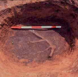
10 Illustrations SS1.1 Irthlingborough Island. Key to trench plans SS1.2 Irthlingborough Island. Trenches in north-west SS1.3 Irthlingborough Island. Trenches in north-east SS1.4 Irthlingborough Island. Trenches in south-west SS1.5 Irthlingborough Island. Trenches in south-east SS1.6 Principal plan and section conventions SS1.7 Long Mound. Overall plan SS1.8 Long Mound. Plan of surface and features beneath east end SS1.9 Long Mound. Plan of surface and features beneath west end between pages 12/13 SS1.10 Long Mound. Sections of F5691 and F5488, beneath the west end SS1.11 Long Mound. Detail and suggested reconstruction of stake alignments in east-central area SS1.12 Long Mound. Stakeholes F5310, F5311, F5312 and F5313 (Part of F290) SS1.13 Long Mound. Plan of west end... between pages 18/19 SS1.14 Long Mound. Plan of east end SS1.15 Long Mound. East end with trial trench, later features and gully emptied and mound still in place, looking east SS1.16 Long Mound. East-central area with later features and gully emptied and mound still in place, looking west SS1.17 Long Mound. Transverse section through west end SS1.18 Long Mound. Oblique section through east end, and transverse sections of the gully SS1.19 Long Mound. Plan of east end showing carbonised plank, gully and stakes in gully SS1.20 Long Mound. Composite section through west end, showing F5488 and quarry pits SS1.21 Long Mound. Burnt wood in F SS1.22 Avenue. Plan SS1.23 Avenue. Sections SS1.24 Avenue. F87575: west face of box section SS1.25 Avenue. F87575: section SS1.26 Avenue. F87651: section SS1.27 Avenue. F87651: north-east face of box section SS1.28 Turf Mound. Overall plan SS1.29 Turf Mound. Excavation at the quarry face SS1.30 Turf Mound. Section A A SS1.31 Turf Mound. Sections B B1, C C1, S SS1.32 Turf Mound. Pre-monument activity SS1.33 Turf Mound. Detail of fully excavated area SS1.34 Turf Mound. Plan and sections of eastern gully SS1.35 Turf Mound. F SS1.36 Turf Mound. Red deer antler exposed near the base of F SS1.37 Long Barrow. Overall plan SS1.38 Long Barrow. From the north-east SS1.39 Long Barrow. Pre-barrow activity SS1.40 Long Barrow. Pit F239 and cist F SS1.41 Long Barrow. Cist F SS1.42 Long Barrow. Facade trench (F161) SS1.43 Long Barrow. Sections through mound and ditches SS1.44 Long Barrow. Ditch layers 183, 184/A, quadrant B SS1.45 Long Barrow. Location of environmental samples and waterlogged wood SS1.46 Long Barrow. Bone, antler and waterlogged wood in north-east butt of north-west ditch (upper); waterlogged wood in south-east ditch (lower) SS1.47 Long Barrow. Waterlogged wood 240, SS1.48 Long Barrow. Waterlogged wood 240, 241, SS1.49 Long Barrow. Waterlogged wood 283, SS1.50 Long Barrow. Distribution of flint debitage SS1.51 Long Barrow. Distribution of retouched flint implements SS1.52 Long Barrow. Distribution of prehistoric pottery SS1.53 Long Barrow. Gravel bank SS1.54 Long Barrow. Location of Beaker burials and middle Bronze Age cremation cemetery SS1.55 Long Barrow. Detailed plans of Beaker burials and middle Bronze Age cremations SS1.56 Long Barrow. Burial F SS1.57 Long Barrow. Detailed plan of posthole alignment SS1.58 Long Barrow. Romano-British ploughmarks and undated features SS1.59 Long Barrow. Phasing SS1.60 Long Enclosure. Overall plan SS1.61 Long Enclosure. North end during excavation SS1.62 Long Enclosure. North end and trial trenches 1629 (west side), 1626 (east side) and 3123 (south end) SS1.63 Long Enclosure. Sections through north end (S534), west side (S549, S581) and south end (S526) SS1.64 Long Enclosure. Sections through east side (S480, S580, S536) SS1.65 Causewayed Ring Ditch. Overall plan and detail of antler in base of recut in south butt SS1.66 Causewayed Ring Ditch. General view at end of excavation viii
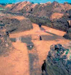
11 SS1.67 Causewayed Ring Ditch. South-north section across monument SS1.68 Causewayed Ring Ditch. South end of S1106 in cutting 38049, showing mollusc-rich layer SS1.69 Causewayed Ring Ditch. Sections SS1.70 Causewayed Ring Ditch. North butt and S SS1.71 Causewayed Ring Ditch. Charred wood on ditch base in north butt, from north SS1.72 Causewayed Ring Ditch. Charred wood (left) and (right) on base of section 38049, from north SS1.73 Causewayed Ring Ditch. Antler implements on base of recut in south butt SS1.74 Southern Enclosure. Plan SS1.75 Southern Enclosure. The east side of the ditch exposed in summer SS1.76 Southern Enclosure. Sections through the ditch butts SS1.77 Southern Enclosure. Section through the east ditch butt SS1.78 Southern Enclosure. Sampling the bottom ditch fills SS1.79 Southern Enclosure. Discrete features SS1.80 Riverside Structure. Excavated area, location of sections and location of stone axe SS1.81 Riverside Structure. Plan SS1.82 Riverside Structure. Composite sections between pages 126/127 SS1.83 Riverside Structure. Work in progress SS1.84 Riverside Structure. Brushwood layer in between two main trunks SS1.85 Riverside Structure. Main alder trunks and some of lower brushwood layer from the north-west SS1.86 Riverside Structure. Axe marks on the outer main alder trunk SS1.87 Ditched Enclosure. Ditch sections SS1.88 Cotton Henge. Results of geophysical survey and contour survey, location of test pits and the gravel content of the soil from them SS1.89 Cotton Henge. Trench plans and sections SS1.90 Segmented Ditch Circle. Plan SS1.91 Segmented Ditch Circle. After excavation SS1.92 Segmented Ditch Circle. Antler pick on surface of primary silt in F SS1.93 Segmented Ditch Circle. Antler pick near base of F SS1.94 Segmented Ditch Circle. Sections SS1.95 Segmented Ditch Circle. Charred oak timber in main fill of F SS1.96 Segmented Ditch Circle. Pit between F87541 and F SS1.97 Segmented Ditch Circle. West face of F87577, with cremation SS1.98 Segmented Ditch Circle. Cremation 6184 in F SS1.99 Barrow 1. Contour survey, undated peripheral features, cairn (30119), primary burial (30426) SS1.100 Barrow 1. Overall plan SS1.101 Barrow 1. Excavation in progress SS1.102 Barrow 1. Sections through primary burial SS1.103 Barrow 1. Charred oak planks over the burial in F SS1.104 Barrow 1. Charred oak planks over the burial in F SS1.105 Barrow 1. Primary burial SS1.106 Barrow 1. The primary grave within the larger grave pit F SS1.107 Barrow 1. Detail of grave goods at feet of primary burial in F SS1.108 Barrow 1. Detail of grave goods at feet of primary burial in F SS1.109 Barrow 1. Grave goods from primary burial SS1.110 Barrow 1. The central cairn (30119) after the removal of the bone SS1.111 Barrow 1. Excavation of the cairn, with Collared Urn context in background SS1.112 Barrow 1. Cairn collapsed into central grave SS1.113 Barrow 1. North-south section S between pages 172/173 SS1.114 Barrow 1. North-east/south-west section S between pages 172/173 SS1.115 Barrow 1. North-west/south-east section S between pages 172/173 SS1.116 Barrow 1. East-west section S between pages 172/173 SS1.117 Barrow 1. Detail of truncated Collared Urn context in situ on cairn SS1.118 Barrow 1. F30017 with uppermost sherds removed, showing dagger and cremation SS1.119 Barrow 1. Secondary burial F SS1.120 Barrow 1. Secondary burial F SS1.121 Barrow 1. Distribution of struck flint in post-mound knapping clusters SS1.122 Barrow 1. Distribution of Iron Age pottery, Roman pottery, Roman slingshots, Roman spearhead and medieval and post medieval pottery SS1.123 Barrow 2. Contour survey and location of 1985 evaluation trench SS1.124 Barrow 3. Contour survey and extent of excavated area SS1.125 Barrow 3. Overall plan SS1.126 Barrow 3. Mound under excavation SS1.127 Barrow 3. Postholes and other features beneath the mound SS1.128 Barrow 3. Postholes and other features beneath the mound ix
12 SS1.129 Barrow 3. Central feature F SS1.130 Barrow 3. Reconstructed geometry of the post rings SS1.131 Barrow 3. Sections of F39102, F30847, F30663, F SS1.132 Barrow 3. F30663, cremation SS1.133 Barrow 3. Limestone scatter in upper mound SS1.134 Barrow 3. Cluster within limestone scatter SS1.135 Barrow 3. Section S between pages 196/197 SS1.136 Barrow 3. Posthole F39477 in the first mound SS1.137 Barrow 3. Posthole F39039 in the first mound SS1.138 Barrow 3. Section S between pages 200/201 SS1.139 Barrow 3. Distribution of struck flint in post-mound knapping cluster SS1.140 Barrow 3. Roman sword SS1.141 Barrow 3. Distribution of Iron Age pottery, Roman pottery and Roman sword SS1.142 Barrow 4. Overall plan SS1.143 Barrow 4. Machining on the mound SS1.144 Barrow 4. Charred oak planks in mound, just above old land surface SS1.145 Barrow 4. South-east to north-west section between pages 212/213 SS1.146 Barrow 4. South-west to north-east section between pages 212/213 SS1.147 Barrow 5. Plan SS1.148 Barrow 5. Central features SS1.149 Barrow 5. Sections SS1.150 Barrow 5. Inverted, truncated urn SS1.151 Barrow 5. Cremation in F SS1.152 Barrow 5. Cremation in F SS1.153 Barrow 6 and Ditched Enclosure. Overall plan SS1.154 Barrow 6 and Ditched Enclosure. Excavation in progress SS1.155 Barrow 6. Composite section SS1.156 Barrow 6. Detail of central area SS1.157 Barrow 6. Burials in F3390 and F SS1.158 Barrow 6. disarticulated remains of two adults in F SS1.159 Barrow 6. Burial in F SS1.160 Barrow 6. Flake, dagger, button, chalk lump and Beaker in situ at feet of burial in F SS1.161 Barrow 6. Detail of flake, dagger, button and chalk lump in situ SS1.162 Barrow 6. Sections through F199, the inner ditch and the middle ditch... between pages 244/245 SS1.163 Barrow 6. Sections through the inner ditch and the middle ditch SS1.164 Barrow 6. Sections through the inner ditch and the middle ditch between pages 245/246 SS1.165 Barrow 6. Section S609 through inner and middle ditches SS1.166 Barrow 6. Sections through the main circuit of the outer ditch SS1.167 Barrow 6. Sections through the main circuit of the outer ditch SS1.168 Barrow 6. Sections through the main circuit and the south-eastern arm of the outer ditch SS1.169 Barrow 6. Cremations SS1.170 Barrow 6. Cremation and Collared Urn in F SS1.171 Barrows 7 and 8. Plan, sections of outer ditch of Barrow 7, detail of grave F SS1.172 Barrow 7. Grave F SS1.173 Barrow 7. Suggested construction sequence SS1.174 Barrow 9. Plan SS1.175 Barrow 9. Aerial view at end of excavation, from the north-east SS1.176 Barrow 9. Grave plans SS1.177 Barrow 9. Burial 747 in central grave F727 from the north-east SS1.178 Barrow 9. Burial 737 in grave F729, from the north-east SS1.179 Barrow 9. Burial 751 in grave F741, looking west SS1.180 Barrow 9. Sections across barrow and through outer and inner ditches SS1.181 Barrow 9. Outer ditch, section 721/A, looking south SS1.182 Barrow 9. Mound 749 overlying barrow SS1.183 Barrow 9. Suggested construction sequence SS1.184 Double Ring Ditch. Plan SS1.185 Double Ring Ditch. Sections SS1.186 West Cotton. Plan of prehistoric monuments and features SS1.187 Minor features. F1737, F1741 and F1744 at West Cotton SS1.188 Minor features. Postpits F4932 and F4933 at West Cotton SS1.189 Minor features. Pit F31820, Stanwick SS1.190 Minor features. Trench B140 at the north end of Irthlingborough island SS1.191 Minor features. Redlands Farm. Pit F SS1.192 Field systems and related structures. Overall plan SS1.193 Field systems and related structures. Trench B SS1.194 Field systems and related structures. Trench B SS1.195 Field systems and related structures. Trench B91. Ditch 9 (F31094), looking north-east. Scale in 100mm divisions SS1.196 Field systems and related structures. Trench B SS1.197 Field systems and related structures. The east of ditches 1 and 3, with ditch SS1.198 Field systems and related structures. Ditches 2 and x
13 SS1.199 Field systems and related structures. Ditch 2 (F38227) SS1.200 Field systems and related structures. Ditch 2, original gaps between F38587 and F38589 and F SS1.201 Field systems and related structures. Ditch 3 (F38430) cut by early Iron Age pit F SS1.202 Field systems and related structures. Ditches 8, 15 and part of 5, with ring ditch F SS1.203 Field systems and related structures. Ditches 12, 18, 19, 20, 21 and 22 with structure between pages 306/307 SS1.204 Field systems and related structures. Ditch 18. Inverted fragmentary cranium SS1.205 Field systems and related structures. Ditches 26, 27 and F87464 with structure between pages 307/308 SS1.206 Field systems and related structures. Ditch 26 (F87402) SS1.207 Field systems and related structures. Intersection of ditch 26 and ditch SS1.208 Field systems and related structures. Ditch 26 (F87469) SS1.209 Field systems and related structures. Ditch 27 (F87578) SS1.210 Field systems and related structures. Ditch 27 (F87646) SS1.211 Field systems and related structures. Ditch F87464 and pit alignment SS1.212 Field systems and related structures. F87432 in pit alignment SS1.213 Field systems and related structures. Middle Bronze Age basal-looped spearhead SS1.214 Field systems and related structures. Redlands Farm. Pre-Roman ditches and possible round house SS1.215 Field systems and related structures. Redlands Farm. Sections of pre-roman ditches SS2.1 Viewshed for the Long Mound SS2.2 Viewshed for the north part of the Turf Mound SS2.3 Viewshed for the Avenue and Segmented Ditch Circle SS2.4 Viewshed for the Long Barrow SS2.5 Viewshed for the Long Enclosure SS2.6 Viewshed for the Causewayed Ring Ditch SS2.7 Viewshed for the Southern Enclosure SS2.8 Viewshed for the Riverside Structure SS2.9 Viewshed for the Ditched Enclosure SS2.10 Viewshed for Ring Ditch SS2.11 Viewshed for Barrow SS2.12 Viewshed for Ring Ditch SS2.13 Viewshed for Flat top barrow SS2.14 Viewshed for Ring Ditch SS2.15 Viewshed for Barrow SS2.16 Viewshed for Ring Ditch SS2.17 Viewshed for Barrow SS2.18 Viewshed for the Double Ring Ditch SS2.19 Viewshed for Barrow SS2.20 Viewshed for Ring Ditch SS2.21 Viewshed for Ring Ditch SS2.22 Viewshed for Ring Ditch SS2.23 Viewshed for Ring Ditch SS2.24 Viewshed for Ring Ditch SS2.25 Viewshed for Barrow SS2.26 Viewshed for Barrow SS2.27 Viewshed for Barrow SS2.28 Viewshed for Barrow SS2.29 Viewshed for Ring Ditch SS2.30 Viewshed for the Cotton Henge SS2.31 The centres of struck flint concentrations SS2.32 Viewshed for the West Cotton struck flint concentration SS2.33 Viewshed for the Redlands Farm struck flint concentration SS2.34 Viewshed for struck flint concentration 26 at Westfield Spinney SS2.35 Viewshed for struck flint concentration 13 at Ringstead Grange SS2.36 Viewshed for the struck flint concentration 8 at Stanwick (west) SS2.37 Viewshed for the struck flint concentration 11a at Mallows Cotton (east) SS2.38 Viewshed for the struck flint concentration 24a at Ringstead Village (north) SS2.39 Viewshed for struck flint concentration 23 at Top Lodge SS2.40 Viewshed for struck flint concentration 24b at Ringstead Village (south) SS2.41 Viewshed for struck flint concentration 1 on Crow Hill SS2.42 Viewshed for struck flint concentration 7 at Nether Field SS2.43 Viewshed for struck flint concentration 6 at Chelveston Lodge SS2.44 Viewshed for struck flint concentration 17 at Musdell SS2.45 Viewshed for struck flint concentration 19 at Home Field SS2.46 Viewshed for struck flint concentration 29 at Thorpe End SS2.47 Viewshed for struck flint concentration 22 at Scaley Field SS2.48 Viewshed for struck flint concentration 18 at Darsdale SS2.49 Viewshed for struck flint concentration 34 at Upper Darsdale (east) SS3.1 Barrow 5. Flint knife or dagger in situ against the exterior of Collared Urn AOR from F xi
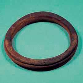
14 SS3.2 Barrow 1. The dagger and pommel from cremation F SS3.3 Barrow 1. The dagger from cremation F SS3.4 Distribution of long oval pommels with pronounced lips SS3.5 Long Barrow. F131, basket earring SS3.6 Long Barrow. Basket earring SS3.7 Barrows 1 and 6. Jet buttons and amber ring SS3.8 EDX spectrum of Whitby jet SS3.9 Scatter diagram of oxygen and carbon content SS3.10 Scatter diagram of aluminium and silicon content SS3.11 Scatter diagram of iron and sulphur content SS3.12 Long Barrow. Shale armlet SS3.13 Long Barrow. Shale armlet SS3.14 Barrow 1. Bone artefacts, spatulae 34859, and from the primary burial SS3.15 Barrow 1. Bone artefacts, boar tusk from the primary burial, pin from inhumation 30449, pin from cremation F SS3.16 Long Barrow. Cut-marked red deer antler from ditch SS3.17 Long Barrow. Cut-marked red deer antler from ditch SS3.18 Long Barrow. Waterlogged wood with axe facets SS3.19 Long Barrow. Detail of waterlogged oak showing axe facets SS3.20 Long Barrow. Detail of waterlogged oak showing axe facet SS3.21 Long Barrow. Waterlogged oak with facet and stop mark fitting flint axehead SS3.22 Stone artefacts. Sf 4572 from the primary burial in Barrow SS3.23 Bracers made of Group VI rock from Barrow 1 at Raunds and from site XII at Dorchester-on-Thames SS3.24 The Stanwick flint axehead hoard SS3.25 The Stanwick flint axehead hoard SS3.26 The Stanwick flint axehead hoard SS3.27 The Higham Ferrers dagger SS3.28 The Higham Ferrers dagger SS3.29 Long Barrow. Struck flint SS3.30 Long Barrow. Struck flint SS3.31 Long Barrow and other contexts at Redlands Farm SS3.32 Long Barrow. Heavy wear on cutting edge of flint axehead SS3.33 Long Mound. Blade widths SS3.34 Barrow 6. Blade widths SS3.35 Non-monument contexts on the terrace. Blade widths SS3.36 Barrow 1. Lengths and widths of all flakes and blades from phase SS3.37 Barrow 3. Lengths and widths of all flakes and blades from phase SS3.38 F Lengths and widths of all flakes and blades SS3.39 Long Mound. Struck flint SS3.40 Long Mound. Struck flint SS3.41 Stray find (57) and Barrow 6 (58). Struck flint SS3.42 Barrow 6 F3259. Struck flint SS3.43 Barrow 6 F3259. Flint dagger SS3.44 Barrow 6 (62 74) and Turf Mound (75). Struck flint SS3.45 Turf Mound (76 82) and Barrow 5 (83 9). Struck flint SS3.46 Barrow 5 (90 93), Long Enclosure (94), Southern Enclosure (95 8), Avenue (99) and Field System (100). Struck flint SS3.47 Grooved Ware pit F31820 (101 20) and miscellaneous contexts on the terrace (103 10).Struck flint SS3.48 Miscellaneous contexts on the terrace. Struck flint SS3.49 Miscellaneous contexts on the terrace. Struck flint SS3.50 Barrow 1 F Struck flint SS3.51 Barrow 1 F Flint dagger SS3.52 Barrow 1 F Struck flint SS3.53 Barrow 1. Struck flint SS3.54 Barrow 1. Struck flint SS3.55 Barrow 1. Struck flint SS3.56 Barrow 3. Struck flint SS3.57 Barrow 4 (178 82) and trench B41 (183). Struck flint SS3.58 Distribution of all microliths, microburins, and axe sharpening flakes from the excavations SS3.59 Long Mound. Length:width diagrams of the blades from context 5291 and F SS3.60 Distribution of all leaf-shaped arrowheads from the excavations SS3.61 Distribution of flakes and fragments from polished flint axeheads, flaked flint axehead and stone axeheads and axehead fragments from the excavations SS3.62 Long Mound. Length:width diagram of the blades from context SS3.63 Distribution of chisel arrowheads, oblique arrowheads and miscellaneous transverse arrowheads SS3.64 Grooved Ware pit F Length:width diagram of flakes and blades SS3.65 Distribution of barbed and tanged arrowheads and triangular arrowheads from the excavations xii
15 SS3.66 Analysis of lipid residues in SFs 4573, 3678, SS3.67 Analysis of lipid residues in SFs 4278, 7688, SS3.68 Analysis of lipid residues in SF SS3.69 Analysis of lipid residues in AORs and SS3.70 Analysis of lipid residues in AORs 15618, 55249, SS3.71 Long Barrow. Peterborough Ware, Beaker and early Bronze Age pottery SS3.72 Long Barrow (P15 P16), Barrow 8 (P17 P18), Barrow 9 (P19) and Redlands Farm F428 (P20). Middle Bronze Age and Beaker SS3.73 Long Barrow. Fired clay object from facade trench SS3.74 Irthlingborough, Stanwick and West Cotton pottery: key to temper diagrams SS3.75 Barrow 6 (P21 P24) and the Long Mound (P25 P28). Plain Neolithic Bowl SS3.76 Long Mound (P29 P30, P32 P45) and miscellaneous contexts (P31). Neolithic Bowl and Ebbsfleet Ware SS3.77 Long Mound (P46 P49), Turf Mound (P50, P53) and Barrow 6 (P51 P52, P55). Ebbsfleet Ware, other Peterborough Ware and decorated Neolithic Bowl SS3.78 Ditched Enclosure (P56), Long Mound (P57, P59), Turf Mound (P58), pit F31820 (P60, P61) and miscellaneous contexts (P62), Barrow 5 (P63). Grooved Ware SS3.79 Long Mound (P64 P65) and Turf Mound (P66 P73). Beaker SS3.80 Turf Mound (P74), miscellaneous contexts (P75 P78, P81 P82), Barrow 1 (P79), Avenue (P80), Barrow 5 (P83), Barrow 6 (P84). Beaker SS3.81 Barrow 1 (P85), structure (P86) and miscellaneous contexts (P87). Beaker and?beaker SS3.82 Long Mound (P88), Turf Mound (P89), Barrow 5 (P90) and Barrow 1 (P91). Early Bronze Age pottery SS3.83 Barrow 1 (P92), Barrow 3 (P93), Barrow 5 (P95,?P94) and Barrow 6 (P96). Early Bronze Age pottery SS3.84 Barrow 6 (P97 P99, P101), miscellaneous contexts (P100, P102) and pit F87688 within Southern Enclosure (P102). Early Bronze Age pottery SS3.85 Barrow 6 (P104 P105, P108 P109) and Long Mound (P106 P107, P110). Early to middle Bronze Age and unclassified pottery SS4.1 Long Barrow. Summary diagram showing concentrations of palynomorphs, microscopic charcoal, iron pyrite framboids, and percentage data for selected taxa in organic ditch deposits SS4.2 Long Barrow. Percentages of all pollen and pteridophyte spore taxa in organic ditch deposits SS4.3 Long Barrow. Seeds of Opium Poppy (Papaver somniferum L) from sample SS4.4 Long Barrow. Left elytron of Scarabaeoid dung beetle (Valgus hemipterus (L)) from sample SS4.5 Long Barrow. Head of Scarabaeoid dung beetle (Caccobius schreberi (L)) from sample SS4.6 Long Barrow. Right elytron of Scarabaeoid dung beetle (Onthophagus taurus) (Schreb) from sample SS4.7 Long Barrow. Composition of waterlogged seeds SS4.8 Long Barrow. Composition of Coleoptera from organic fills of ditches SS4.9 Palaeochannels. Species groups of Coleoptera from Neolithic and Bronze Age sediments in the West Cotton palaeochannel SS4.10 Barrow 1. Tuberous root 1 from sample 11254, context in peripheral cremation F SS4.11 Barrow 1. Tuberous root 1 from sample 11254, context in peripheral cremation F30307, second view SS4.12 Barrow 1. Round tuber type A from sample 11076, context in cremation F SS4.13 Barrow 1. Round tuber type A from sample 11076, context in cremation F SS4.14 Barrow 1. Item B from sample 11254, context in peripheral cremation F SS4.15. Barrow 1. General plan and extent of bone scatter SS4.16. Barrow 1. Posterior views of cattle M1, M2 and M3 to show the distinction between them SS4.17. Barrow 1. Measurement of the circumference of a cattle upper molar SS4.18. Barrow 1. Measurement of crown height SS4.19. Barrow 1. Wear stages and variants of cattle upper teeth SS4.20. Barrow 1. Circumferences of upper first, second and third molars of cattle from Irthlingborough SS4.21. Barrow 1. Size change in north European cattle lower third molars and the identification of the Barrow SS4.22. Barrow 1. The aurochs molars SS4.23. Barrow 1. Sketch to show which body parts are represented SS4.24. Barrow 1. Distributions of crown heights of cattle upper teeth and crown height variation SS4.25. Barrow 1. Cattle scapula SLC xiii
The lithic assemblage from Kingsdale Head (KH09)
") 1 The lithic assemblage from Kingsdale Head (KH09) Hannah Russ Introduction During excavation the of potential Mesolithic features at Kingsdale Head in 2009 an assemblage of flint and chert artefacts were
1 The lithic assemblage from Kingsdale Head (KH09) Hannah Russ Introduction During excavation the of potential Mesolithic features at Kingsdale Head in 2009 an assemblage of flint and chert artefacts were
Lanton Lithic Assessment
 Lanton Lithic Assessment Dr Clive Waddington ARS Ltd The section headings in the following assessment report refer to those in the Management of Archaeological Projects (HBMC 1991), Appendix 4. 1. FACTUAL
Church of St Peter and St Paul, Great Missenden, Buckinghamshire
 Church of St Peter and St Paul, Great Missenden, Buckinghamshire An Archaeological Watching Brief for the Parish of Great Missenden by Andrew Taylor Thames Valley Archaeological Services Ltd Site Code
3 The Development of the Monuments
 3 The Development of the Monuments Frances Healy, Jan Harding and Alex Bayliss Look on this dust the living and the dead Are in its atoms present life and past Are all its future John Clare, The Churchyard
Bronze Age 2, BC
 Bronze Age 2,000-600 BC There may be continuity with the Neolithic period in the Early Bronze Age, with the harbour being used for seasonal grazing, and perhaps butchering and hide preparation. In the
McDONALD INSTITUTE MONOGRAPHS. Spong Hill. Part IX: chronology and synthesis. By Catherine Hills and Sam Lucy
 McDONALD INSTITUTE MONOGRAPHS Spong Hill Part IX: chronology and synthesis By Catherine Hills and Sam Lucy with contributions from Mary Chester-Kadwell, Susanne Hakenbeck, Frances Healy, Kenneth Penn,
Archaeological Material From Spa Ghyll Farm, Aldfield
 Archaeological Material From Spa Ghyll Farm, Aldfield Introduction Following discussions with Linda Smith the Rural Archaeologist for North Yorkshire County Council, Robert Morgan of 3D Archaeological
Moray Archaeology For All Project
 School children learning how to identify finds. (Above) A flint tool found at Clarkly Hill. Copyright: Leanne Demay Moray Archaeology For All Project ational Museums Scotland have been excavating in Moray
3. The new face of Bronze Age pottery Jacinta Kiely and Bruce Sutton
 3. The new face of Bronze Age pottery Jacinta Kiely and Bruce Sutton Illus. 1 Location map of Early Bronze Age site at Mitchelstown, Co. Cork (based on the Ordnance Survey Ireland map) A previously unknown
Chapter 2: Archaeological Description
 Chapter 2: Archaeological Description Phase 1 Late Neolithic, c 3000-2400 BC (Figs 6-9) Evidence of Neolithic activity was confined to pits dug across the southern half of the site (Fig. 6). Eighteen pits
7. Prehistoric features and an early medieval enclosure at Coonagh West, Co. Limerick Kate Taylor
 7. Prehistoric features and an early medieval enclosure at Coonagh West, Co. Limerick Kate Taylor Illus. 1 Location of the site in Coonagh West, Co. Limerick (based on the Ordnance Survey Ireland map)
Bristol & Gloucestershire Archaeological Society
 Chris Hayden, Rob Early, Edward Biddulph, Paul Booth, Anne Dodd, Alex Smith, Granville Laws and Ken Welsh, Horcott Quarry, Fairford and Arkell's Land, Kempsford: Prehistoric, Roman and Anglo-Saxon settlement
Fieldwalking at Cottam 1994 (COT94F)
") Fieldwalking at Cottam 1994 (COT94F) Tony Austin & Elizabeth Jelley (19 Jan 29) 1. Introduction During the winter of 1994 students from the Department of Archaeology at the University of York undertook
Fieldwalking at Cottam 1994 (COT94F) Tony Austin & Elizabeth Jelley (19 Jan 29) 1. Introduction During the winter of 1994 students from the Department of Archaeology at the University of York undertook
New Composting Centre, Ashgrove Farm, Ardley, Oxfordshire
 New Composting Centre, Ashgrove Farm, Ardley, Oxfordshire An Archaeological Watching Brief For Agrivert Limited by Andrew Weale Thames Valley Archaeological Services Ltd Site Code AFA 09/20 August 2009
SALVAGE EXCAVATIONS AT OLD DOWN FARM, EAST MEON
 Proc. Hants. Field Club Archaeol. Soc. 36, 1980, 153-160. 153 SALVAGE EXCAVATIONS AT OLD DOWN FARM, EAST MEON By RICHARD WHINNEY AND GEORGE WALKER INTRODUCTION The site was discovered by chance in December
Grim s Ditch, Starveall Farm, Wootton, Woodstock, Oxfordshire
 Grim s Ditch, Starveall Farm, Wootton, Woodstock, Oxfordshire An Archaeological Recording Action For Empire Homes by Steve Ford Thames Valley Archaeological Services Ltd Site Code SFW06/118 November 2006
A visit to the Wor Barrow 21 st November 2015
 A visit to the Wor Barrow 21 st November 2015 Following our exploration of Winkelbury a few weeks previously, we fast forwarded 12 years in Pitt Rivers remarkable series of excavations and followed him
Greater London Region GREATER LONDON 3/567 (E.01.K099) TQ BERMONDSEY STREET AND GIFCO BUILDING AND CAR PARK
 TQ BERMONDSEY STREET AND GIFCO BUILDING AND CAR PARK") GREATER LONDON 3/567 (E.01.K099) TQ 33307955 156-170 BERMONDSEY STREET AND GIFCO BUILDING AND CAR PARK Assessment of an Archaeological Excavation at 156-170 Bermondsey Street and GIFCO Building and Car
GREATER LONDON 3/567 (E.01.K099) TQ 33307955 156-170 BERMONDSEY STREET AND GIFCO BUILDING AND CAR PARK Assessment of an Archaeological Excavation at 156-170 Bermondsey Street and GIFCO Building and Car
A Fieldwalking Project At Sompting. West Sussex
 by John Funnell Introduction A Fieldwalking Project At Sompting. West Sussex During March -and April 1995 the Brighton and Hove Archaeological Society conducted fie1dwa1king in a field at Sompting West
ARCHAEOLOGICAL EVALUATION AT BRIGHTON POLYTECHNIC, NORTH FIELD SITE, VARLEY HALLS, COLDEAN LANE, BRIGHTON. by Ian Greig MA AIFA.
 ARCHAEOLOGICAL EVALUATION AT BRIGHTON POLYTECHNIC, NORTH FIELD SITE, VARLEY HALLS, COLDEAN LANE, BRIGHTON by Ian Greig MA AIFA May 1992 South Eastern Archaeological Services Field Archaeology Unit White
St Germains, Tranent, East Lothian: the excavation of Early Bronze Age remains and Iron Age enclosed and unenclosed settlements
 Proc Soc Antiq Scot, 128 (1998), 203-254 St Germains, Tranent, East Lothian: the excavation of Early Bronze Age remains and Iron Age enclosed and unenclosed settlements Derek Alexander* & Trevor Watkinsf
THE RAVENSTONE BEAKER
 DISCOVERY THE RAVENSTONE BEAKER K. J. FIELD The discovery of the Ravenstone Beaker (Plate Xa Fig. 1) was made by members of the Wolverton and District Archaeological Society engaged on a routine field
Hembury Hillfort Lesson Resources. For Key Stage Two
 Hembury Hillfort Lesson Resources For Key Stage Two 1 Resource 1 Email 1 ARCHAEOLOGISTS NEEDED Dear Class, I recently moved to Payhembury and I have been having fun exploring the beautiful Blackdown Hills.
Changing People Changing Landscapes: excavations at The Carrick, Midross, Loch Lomond Gavin MacGregor, University of Glasgow
 Changing People Changing Landscapes: excavations at The Carrick, Midross, Loch Lomond Gavin MacGregor, University of Glasgow Located approximately 40 kilometres to the south-west of Oban, as the crow flies
Specialist Report 11 Worked Flint by Hugo Anderson-Whymark
 London Gateway Iron Age and Roman Salt Making in the Thames Estuary Excavation at Stanford Wharf Nature Reserve, Essex Specialist Report 11 Worked Flint by Hugo Anderson-Whymark Specialist Report 11 Worked
BALNUARAN. of C LAVA. a prehistoric cemetery. A Visitors Guide to
 A Visitors Guide to BALNUARAN of C LAVA a prehistoric cemetery Milton of Clava Chapel (?) Cairn River Nairn Balnuaran of Clava is the site of an exceptionally wellpreserved group of prehistoric burial
UNCORRECTED ARCHIVE REPORT. APPENDIX 4 - EARLY PREHISTORIC POTTERY by Alistair Barclay
 UNCORRECTED ARCHIVE REPORT APPENDIX 4 - EARLY PREHISTORIC POTTERY by Alistair Barclay Introduction This report describes the Neolithic and early to middle Bronze Age pottery (72 sherds, 2966 g) recovered
Greater London GREATER LONDON 3/606 (E ) TQ
 TQ") GREATER LONDON City of London 3/606 (E.01.6024) TQ 30358150 1 PLOUGH PLACE, CITY OF LONDON An Archaeological Watching Brief at 1 Plough Place, City of London, London EC4 Butler, J London : Pre-Construct
GREATER LONDON City of London 3/606 (E.01.6024) TQ 30358150 1 PLOUGH PLACE, CITY OF LONDON An Archaeological Watching Brief at 1 Plough Place, City of London, London EC4 Butler, J London : Pre-Construct
2 Saxon Way, Old Windsor, Berkshire
 2 Saxon Way, Old Windsor, Berkshire An Archaeological Watching Brief For Mrs J. McGillicuddy by Pamela Jenkins Thames Valley Archaeological Services Ltd Site Code SWO 05/67 August 2005 Summary Site name:
STONES OF STENNESS HISTORIC ENVIRONMENT SCOTLAND STATEMENT OF SIGNIFICANCE
 Property in Care (PIC) ID: PIC321 Designations: Scheduled Monument (SM90285); Taken into State care: 1906 (Guardianship) Last reviewed: 2003 HISTORIC ENVIRONMENT SCOTLAND STATEMENT OF SIGNIFICANCE STONES
Fieldwalk On Falmer Hill, Near Brighton - Second Season
 Fieldwalk On Falmer Hill, Near Brighton - Second Season by the Brighton and Hove Archaeological Society This report as well as describing the recent fieldwalks also includes descriptions of previous discoveries
Chapter 2. Remains. Fig.17 Map of Krang Kor site
 Chapter 2. Remains Section 1. Overview of the Survey Area The survey began in January 2010 by exploring the site of the burial rootings based on information of the rooted burials that was brought to the
Former Whitbread Training Centre Site, Abbey Street, Faversham, Kent Interim Archaeological Report Phase 1 November 2009
 Former Whitbread Training Centre Site, Abbey Street, Faversham, Kent Interim Archaeological Report Phase 1 November 2009 SWAT. Archaeology Swale and Thames Archaeological Survey Company School Farm Oast,
Grange Farm, Widmer End, Hughenden, Buckinghamshire
 Grange Farm, Widmer End, Hughenden, Buckinghamshire An Archaeological Evaluation for British Flora by Andy Taylor Thames Valley Archaeological Services Ltd Site Code GFH 05/63 July 2005 Summary Site name:
An archaeological evaluation at 16 Seaview Road, Brightlingsea, Essex February 2004
 An archaeological evaluation at 16 Seaview Road, Brightlingsea, Essex February 2004 report prepared by Kate Orr on behalf of Highfield Homes NGR: TM 086 174 (c) CAT project ref.: 04/2b ECC HAMP group site
Archaeological sites and find spots in the parish of Burghclere - SMR no. OS Grid Ref. Site Name Classification Period
 Archaeological sites and find spots in the parish of Burghclere - SMR no. OS Grid Ref. Site Name Classification Period SU45NE 1A SU46880 59200 Ridgemoor Farm Inhumation Burial At Ridgemoor Farm, on the
Test-Pit 3: 31 Park Street (SK )
") -Pit 3: 31 Park Street (SK 40732 03178) -Pit 3 was excavated in a flower bed in the rear garden of 31 Park Street, on the northern side of the street and west of an alleyway leading to St Peter s Church,
-Pit 3: 31 Park Street (SK 40732 03178) -Pit 3 was excavated in a flower bed in the rear garden of 31 Park Street, on the northern side of the street and west of an alleyway leading to St Peter s Church,
FURTHER MIDDLE SAXON EVIDENCE AT COOK STREET, SOUTHAMPTON (SOU 567)
") Roc. Hampshire Field Club Archaeol. Soc 52,1997, 77-87 (Hampshire Studies 1997) FURTHER MIDDLE SAXON EVIDENCE AT COOK STREET, SOUTHAMPTON (SOU 567) By M F GARNER andj VINCENT with a contribution byjacqueline
Roc. Hampshire Field Club Archaeol. Soc 52,1997, 77-87 (Hampshire Studies 1997) FURTHER MIDDLE SAXON EVIDENCE AT COOK STREET, SOUTHAMPTON (SOU 567) By M F GARNER andj VINCENT with a contribution byjacqueline
Novington, Plumpton East Sussex
 Novington, Plumpton East Sussex The Flint Over 1000 pieces of flintwork were recovered during the survey, and are summarised in Table 0. The flint is of the same types as found in the previous survey of
A NOTE FROM THE ERMINE STREET DIG HUNTINGDON September 2013 EDITOR
 A NOTE FROM THE EDITOR This is the first newsletter since the merger of Mid Anglia and East Anglia in 2012. The newsletter will be published bi- annually in March and September. We invite contributions
Overview: From Neolithic to Bronze Age, BC
 Overview: From Neolithic to Bronze Age, 8000-800 BC By Dr Francis Pryor Last updated 2011-02-28 The British Isles have been populated by human beings for hundreds of thousands of years, but it was the
Advanced archaeology at the archive. Museum of London Support materials AS/A2 study day
 Advanced archaeology at the archive Support materials AS/A2 study day Contents National Curriculum links and session description 1-2 Example timetable 3 Practical guidelines 4 Visit preparation and pre-visit
16 members of the Fieldwalking Group met York Community Archaeologist Jon Kenny at Lou Howard s farm, Rose Cottage Farm, at
 Terrington History Group Fieldwalking Group Field 1 Final report 21 October 2011 - fieldwalking 16 members of the Fieldwalking Group met York Community Archaeologist Jon Kenny at Lou Howard s farm, Rose
An archaeological evaluation by trial-trenching at Playgolf, Bakers Lane, Westhouse Farm, Colchester, Essex
 An archaeological evaluation by trial-trenching at Playgolf, Bakers Lane, Westhouse Farm, Colchester, Essex commissioned by Mr Stephen Belchem on behalf of ADP Ltd. report prepared by Chris Lister Planning
39, Walnut Tree Lane, Sudbury (SUY 073) Planning Application No. B/04/02019/FUL Archaeological Monitoring Report No. 2005/112 OASIS ID no.
 Planning Application No. B/04/02019/FUL Archaeological Monitoring Report No. 2005/112 OASIS ID no.") 39, Walnut Tree Lane, Sudbury (SUY 073) Planning Application No. B/04/02019/FUL Archaeological Monitoring Report No. 2005/112 OASIS ID no. 9273 Summary Sudbury, 39, Walnut Tree Lane, Sudbury (TL/869412;
39, Walnut Tree Lane, Sudbury (SUY 073) Planning Application No. B/04/02019/FUL Archaeological Monitoring Report No. 2005/112 OASIS ID no. 9273 Summary Sudbury, 39, Walnut Tree Lane, Sudbury (TL/869412;
An archaeological evaluation at the Lexden Wood Golf Club (Westhouse Farm), Lexden, Colchester, Essex
, Lexden, Colchester, Essex") An archaeological evaluation at the Lexden Wood Golf Club (Westhouse Farm), Lexden, Colchester, Essex January 2000 Archive report on behalf of Lexden Wood Golf Club Colchester Archaeological Trust 12 Lexden
An archaeological evaluation at the Lexden Wood Golf Club (Westhouse Farm), Lexden, Colchester, Essex January 2000 Archive report on behalf of Lexden Wood Golf Club Colchester Archaeological Trust 12 Lexden
An archaeological watching brief and recording at Brightlingsea Quarry, Moverons Lane, Brightlingsea, Essex October 2003
 An archaeological watching brief and recording at Brightlingsea Quarry, Moverons Lane, Brightlingsea, Essex commissioned by Mineral Services Ltd on behalf of Alresford Sand & Ballast Co Ltd report prepared
Cambridge Archaeology Field Group. Fieldwalking on the Childerley Estate, Cambridgeshire. Autumn 2014 to Spring Third interim report
 Cambridge Archaeology Field Group Fieldwalking on the Childerley Estate, Cambridgeshire Autumn 2014 to Spring 2015 Third interim report Summary Field walking on the Childerley estate of Martin Jenkins
Moated Site at Manor Farm, Islip, Oxfordshire
 Moated Site at Manor Farm, Islip, Oxfordshire An Archaeological Excavation By Jo Pine Site Code MFI05 December 2007 Summary Site name: Moated Site at Manor Farm, Islip, Oxfordshire Grid reference: SP 5298
Silwood Farm, Silwood Park, Cheapside Road, Ascot, Berkshire
 Silwood Farm, Silwood Park, Cheapside Road, Ascot, Berkshire An Archaeological Watching Brief For Imperial College London by Tim Dawson Thames Valley Archaeological Services Ltd Site Code SFA 09/10 April
Erection of wind turbine, Mains of Loanhead, Old Rayne, AB52 6SX
 Erection of wind turbine, Mains of Loanhead, Old Rayne, AB52 6SX Ltd 23 November 2011 Erection of wind turbine, Mains of Loanhead, Old Rayne, AB52 6SX CONTENTS 1 INTRODUCTION 3 2 ARCHAEOLOGICAL BACKGROUND
ARCHAEOLOGICAL EXCAVATION REPORT: THE PADDOCK, HIGH DIKE, NAVENBY, LINCOLNSHIRE
 ARCHAEOLOGICAL EXCAVATION REPORT: THE PADDOCK, HIGH DIKE, NAVENBY, LINCOLNSHIRE NGR: 499398, 357274 AAL Site Code: NAPA 13 OASIS Reference Number: allenarc1-205997 Report prepared for Navenby Archaeology
THREE BRONZE AGE BARROWS AT MOCKBEGGAR LANE,fflSLEY,HAMPSHIRE
 Proc. Hampshire Field Club Archaeol. Soc. 59, 2004, 31-64 (Hampshire Studies 2004) THREE BRONZE AGE BARROWS AT MOCKBEGGAR LANE,fflSLEY,HAMPSHIRE By SARAH COLES with contributions by SlAN ANTHONY, STEVE
Evidence for the use of bronze mining tools in the Bronze Age copper mines on the Great Orme, Llandudno
 Evidence for the use of bronze mining tools in the Bronze Age copper mines on the Great Orme, Llandudno Background The possible use of bronze mining tools has been widely debated since the discovery of
Archaeological Development Services; National Road Design Department, Sligo County Council (App. 15.2) Page - 1
 Page - 1") N4 Collooney to Castlebaldwin, Proposed Road Development APPENDIIX NO.. 15..2 Topographiic Fiilles (NMII) PREPARED BY:: Archaeological Development Services; National Road Design Department, Council (App.
N4 Collooney to Castlebaldwin, Proposed Road Development APPENDIIX NO.. 15..2 Topographiic Fiilles (NMII) PREPARED BY:: Archaeological Development Services; National Road Design Department, Council (App.
Early prehistoric petrology: A case study from Leicestershire.
 Early prehistoric petrology: A case study from Leicestershire. Item Type Thesis Authors Parker, Matthew J. Rights
Colchester Archaeological Trust Ltd. A Fieldwalking Survey at Birch, Colchester for ARC Southern Ltd
 Colchester Archaeological Trust Ltd A Fieldwalking Survey at Birch, Colchester for ARC Southern Ltd November 1997 CONTENTS page Summary... 1 Background... 1 Methods... 1 Retrieval Policy... 2 Conditions...
To the memory of Graham Ritchie
 Proc Soc Antiq Scot 140 (2010), 51 77 dating balbirnie 51 Dating Balbirnie: recent radiocarbon dates from the stone circle and cairn at Balbirnie, Fife, and a review of its place in the overall Balfarg/Balbirnie
Essex Historic Environment Record/ Essex Archaeology and History
 Essex Historic Environment Record/ Essex Archaeology and History CAT Report 578 Summary sheet Address: Kingswode Hoe School, Sussex Road, Colchester, Essex Parish: Colchester NGR: TL 9835 2528 Type of
2.Valley bottom and hilltop: 6,000 years of settlement along the route of the N4 Sligo Inner Relief Road Michael MacDonagh
 2.Valley bottom and hilltop: 6,000 years of settlement along the route of the N4 Sligo Inner Relief Road Michael MacDonagh Illus. 1 Aerial view of archaeological test-trenches along the route of the N4
Archaeological Evaluation at Alconbury Weald Enterprise Zone
 Archaeological Evaluation at Alconbury Weald Enterprise Zone Archaeological Evaluation Report June 2015 Client: CgMS OA East Report No: 1768 OASIS No: oxfordar3-212519 NGR: TL 1975 7684 Archaeological
Fort Arbeia and the Roman Empire in Britain 2012 FIELD REPORT
 Fort Arbeia and the Roman Empire in Britain 2012 FIELD REPORT Background Information Lead PI: Paul Bidwell Report completed by: Paul Bidwell Period Covered by this report: 17 June to 25 August 2012 Date
Wantage County Primary School, Garston Lane, Wantage, Oxfordshire
 Wantage County Primary School, Garston Lane, Wantage, Oxfordshire An Archaeological Evaluation for Oxfordshire County Council by Erlend Hindmarch Thames Valley Archaeological Services Ltd Site Code GLW
Forteviot, Perthshire 2008: Excavations of a henge monument and timber circle. Data Structure and Interim Report. by Gordon Noble and Kenneth Brophy
 Forteviot, Perthshire 2008: Excavations of a henge monument and timber circle Data Structure and Interim Report by Gordon Noble and Kenneth Brophy Summary This interim report will describe the provisional
Neolithic and Roman remains on the Lufkins Farm reservoir site, Great Bentley, Essex October-November 2007
 Neolithic and Roman remains on the Lufkins Farm reservoir site, Great Bentley, Essex report prepared by Howard Brooks and Ben Holloway on behalf of A O Poole & Sons and George Wright Farms NGR: TM 0975
RESCUE EXCAVATIONS ON BRONZE AGE SITES IN THE SOUTH WONSTON AREA
 Proc. Hampsh. Field Club Archaeol. Soc. 43, 1987, 5-14 RESCUE EXCAVATIONS ON BRONZE AGE SITES IN THE SOUTH WONSTON AREA By RICHARD WHINNEY ABSTRACT BRONZE AGE BACKGROUND (Fig lc) Four small rescue and
Date. Necklace of bones and stone beads found in Carrowmore 55A. (Published with the permission of the National Museum of Ireland)
") Necklace of bones and stone beads found in Carrowmore 55A. (Published with the permission of the National Museum of Ireland) Carrowmore 37, with its very small chamber, less than 0.5m 2. (Photo: Stefan
Necklace of bones and stone beads found in Carrowmore 55A. (Published with the permission of the National Museum of Ireland) Carrowmore 37, with its very small chamber, less than 0.5m 2. (Photo: Stefan
This is a repository copy of Anglo-Saxon settlements and archaeological visibility in the Yorkshire Wolds.
 This is a repository copy of Anglo-Saxon settlements and archaeological visibility in the Yorkshire Wolds. White Rose Research Online URL for this paper: http://eprints.whiterose.ac.uk/1172/ Book Section:
The Living and the Dead
 The Living and the Dead Round Barrows and cairns The transition from the late Neolithic to the early Bronze Age is traditionally associated with an influx of immigrants to the British Isles from continental
Teachers Pack
 Whitehorse Hill: A Prehistoric Dartmoor Discovery 13.09.14-13.12.14 Teachers Pack CONTENTS About the Teachers Pack 05 Introduction to the exhibition 05 Prehistoric Britain - Timeline 05 What changed? Technology,
A Sense of Place Tor Enclosures
 A Sense of Place Tor Enclosures Tor enclosures were built around six thousand years ago (4000 BC) in the early part of the Neolithic period. They are large enclosures defined by stony banks sited on hilltops
1. Presumed Location of French Soundings Looking NW from the banks of the river.
 SG02? SGS SG01? SG4 1. Presumed Location of French Soundings Looking NW from the banks of the river. The presumed location of SG02 corresponds to a hump known locally as the Sheikh's tomb. Note also (1)
THE EXCAVATION OF A BURNT MOUND AT HARBRIDGE, HAMPSHIRE
 Proc Hampshire Field ClubArchaeolSoc5i, 1999,172-179 (Hampshire Studies 1999) THE EXCAVATION OF A BURNT MOUND AT HARBRIDGE, HAMPSHIRE by S J SHENNAN ABSTRACT A burnt mound of Late Brome Age date, as indicated
Notes on Two Bronze Age Discoveries 1n Leicestershire by
 Notes on Two Bronze Age Discoveries 1n Leicestershire by T. G. E. Powell (1) Bronze Age Cremation Burial from Earl Shilton In the course of sand digging in 1938, an urn containing cremated bones was found
Archaeological trial-trenching evaluation at Chappel Farm, Little Totham, Essex. April 2013
 Archaeological trial-trenching evaluation at Chappel Farm, Little Totham, Essex April 2013 report prepared by Ben Holloway commissioned by Tim Harbord Associates on behalf of Mr Tom Howie Planning reference:
An archaeological evaluation in the playground of Colchester Royal Grammar School, Lexden Road, Colchester, Essex
 An archaeological evaluation in the playground of Colchester Royal Grammar School, Lexden Road, Colchester, Essex February 2002 on behalf of Roff Marsh Partnership CAT project code: 02/2c Colchester Museum
North West Cambridge, University of Cambridge Archaeological Evaluation Fieldwork
 North West Cambridge, University of Cambridge Archaeological Evaluation Fieldwork Christopher Evans & Richard Newman With contributions by Katie Anderson, Grahame Appleby, Emma Beadsmoore, Lawrence Billington,
MUSEUM LffiRARY. George C. Vaillant Book Fund
 MUSEUM LffiRARY UNIVERSITY OF PENNSYLVANIA George C. Vaillant Book Fund AN EARLY VILLAGE SITE AT ZAWI CHEMI SHANIDAR UNDENA PUBLICATIONS MALIBU 1981 23tbliotl)cca ruceepctamlca PrimaJY sources and interpretive
Cambridge Archaeology Field Group. Fieldwalking on the Childerley Estate Cambridgeshire
 Cambridge Archaeology Field Group Fieldwalking on the Childerley Estate Cambridgeshire 2009 to 2014 Summary Fieldwalking on the Childerley estate of Martin Jenkins and Family has revealed, up to March
An Archaeological Resource Assessment of the Neolithic and Early Bronze Age in Lincolnshire
 Steven Membery An Archaeological Resource Assessment of the Neolithic and Early Bronze Age in Lincolnshire Note: For copyright reasons the figures are currently omitted from the web version of this paper.
LAND WEST OF ELM GROVE, EBRINGTON, GLOUCESTERSHIRE. NGR: SP (centred) ARCHAEOLOGICAL EVALUATION
 ARCHAEOLOGICAL EVALUATION") LAND WEST OF ELM GROVE, EBRINGTON, GLOUCESTERSHIRE. NGR: SP 1892 4012 (centred) ARCHAEOLOGICAL EVALUATION Report No. 640 May 2009 1q LAND WEST OF ELM GROVE, EBRINGTON, GLOUCESTERSHIRE. NGR: SP 1892 4012
LAND WEST OF ELM GROVE, EBRINGTON, GLOUCESTERSHIRE. NGR: SP 1892 4012 (centred) ARCHAEOLOGICAL EVALUATION Report No. 640 May 2009 1q LAND WEST OF ELM GROVE, EBRINGTON, GLOUCESTERSHIRE. NGR: SP 1892 4012
KNAP OF HOWAR HISTORIC ENVIRONMENT SCOTLAND STATEMENT OF SIGNIFICANCE. Property in Care (PIC) ID: PIC301 Designations:
 ID: PIC301 Designations:") Property in Care (PIC) ID: PIC301 Designations: Scheduled Monument (SM90195) Taken into State care: 1954 (Guardianship) Last reviewed: 2004 HISTORIC ENVIRONMENT SCOTLAND STATEMENT OF SIGNIFICANCE KNAP
Property in Care (PIC) ID: PIC301 Designations: Scheduled Monument (SM90195) Taken into State care: 1954 (Guardianship) Last reviewed: 2004 HISTORIC ENVIRONMENT SCOTLAND STATEMENT OF SIGNIFICANCE KNAP
A Bronze Age Round Barrow Cemetery, Pit Alignments, Iron Age Burials, Iron Age Copper Working, and Later Activity at Four Crosses, Llandysilio, Powys
 Archaeological Journal ISSN: 0066-5983 (Print) 2373-2288 (Online) Journal homepage: http://www.tandfonline.com/loi/raij20 A Bronze Age Round Barrow Cemetery, Pit Alignments, Iron Age Burials, Iron Age
Undley Hall, Lakenheath LKH 307
 ARCHAEOLOGICAL EVALUATION AND MONITORING REPORT SCCAS REPORT No. 2010/005 Undley Hall, Lakenheath LKH 307 E. Muldowney SCCAS January 2010 www.suffolkcc.gov.uk/e-and-t/archaeology Lucy Robinson, County
Chapel House Wood Landscape Project. Interim Report 2013
 Chapel House Wood Landscape Project Interim Report 2013 Chapel House Wood Landscape Project Interim Report 2013 The annual Dales Heritage Field School was held at Chapel House Wood again this year, and
Bronze-Age and Romano-British Sites South-East of Tewkesbury: evaluations and excavations
 From the Transactions of the Bristol and Gloucestershire Archaeological Society Bronze-Age and Romano-British Sites South-East of Tewkesbury: evaluations and excavations 1991-7 by G. Walker, A. Thomas
1996 Figurine Report Naomi Hamilton
 1996 Figurine Report Naomi Hamilton THE FIGURINES AND OTHER SMALL FINDS Naomi Hamilton Some preliminary comments on the distribution of certain types of artefact, with particular attention to the trench
Excavation of Iron-Age and Roman Occupation at Coln Gravel, Thornhill Farm,Fairford, Gloucestershire, 2003 and 2004.
 From the Transactions of the Bristol and Gloucestershire Archaeological Society Excavation of Iron-Age and Roman Occupation at Coln Gravel, Thornhill Farm,Fairford, Gloucestershire, 2003 and 2004. by Dan
The excavation of a coastal promontory fort at Porth y Rhaw, Solva, Pembrokeshire,
 Archaeologia Cambrensis 159 (2010), 53 98 The excavation of a coastal promontory fort at Porth y Rhaw, Solva, Pembrokeshire, 1995 98 By PETE CRANE and KENNETH MURPHY 1 with contributions by A. E. Caseldine
1 The East Oxford Archaeology and History Project
 1 The East Oxford Archaeology and History Project EXOP TEST PIT 72 Location: Bartlemas Chapel, Cowley Date of excavation: 6-8 November 2013. Area of excavation: 0.8m x 1.2m, at the eastern end of the chapel.
Round Barrows in Chalcolithic and Early Bronze Age Yorkshire
 Round Barrows in Chalcolithic and Early Bronze Age Yorkshire Architecture, Burial, and Landscape David G. Cockcroft Doctor of Philosophy School of History, Classics, and Archaeology April 2015 Abstract
Prehistoric, Roman and Anglo-Saxon Activity at the Willow Brook Centre, Bradley Stoke, South Gloucestershire
 Trans. Bristol & Gloucestershire Archaeological Society 129 (2011), 11 35 Prehistoric, Roman and Anglo-Saxon Activity at the Willow Brook Centre, Bradley Stoke, South Gloucestershire By ANDREW SIMMONDS
By Lisa Brown. Trench 1. Residual pottery. 4.1 The later prehistoric pottery
 4.1 The later prehistoric pottery By Lisa Brown 4.1.9 Introduction What follows are detailed trench by trench descriptions of the pottery, complementing the discussions in the Alfred s Castle monograph.
Nea Farm, Phase GP5, Somerley, Ringwood, Hampshire
 Nea Farm, Phase GP5, Somerley, Ringwood, Hampshire An Archaeological Excavation for Tarmac Southern Ltd by Andy Taylor Thames Valley Archaeological Services Ltd Site Code SOM07/114 List of Figures Figure
Caistor Roman Project Interim Summary of 2015 Season of Test pits at Caistor Old Hall
 Caistor Roman Project Interim Summary of 2015 Season of Test pits at Caistor Old Hall Introduction This brief report summarises the first results of the 2015 campaign of test-pitting in the grounds of
Whitton Church Lane (Recreation Ground) WHI 014
 WHI 014") ARCHAEOLOGICAL EVALUATION REPORT Whitton Church Lane (Recreation Ground) WHI 014 A REPORT ON THE ARCHAEOLOGICAL EVALUATION, 2008 (Planning app. no. 1362/05/FUL) Jezz Meredith Field Team Suffolk C.C. Archaeological
ARCHAEOLOGICAL EVALUATION REPORT Whitton Church Lane (Recreation Ground) WHI 014 A REPORT ON THE ARCHAEOLOGICAL EVALUATION, 2008 (Planning app. no. 1362/05/FUL) Jezz Meredith Field Team Suffolk C.C. Archaeological
I MADE THE PROBLEM UP,
 This assignment will be due Thursday, Oct. 12 at 10:45 AM. It will be late and subject to the late penalties described in the syllabus after Friday, Oct. 13, at 10:45 AM. Complete submission of this assignment
An archaeological evaluation by trial-trenching at Scotts Farm, Lodge Lane, Purleigh, Essex October 2011
 An archaeological evaluation by trial-trenching at Scotts Farm, Lodge Lane, Purleigh, Essex October 2011 report prepared by Adam Wightman on behalf of Richard Emans CAT project ref.: 11/10a NGR: TL 582719
Archaeological evaluation at the Onley Arms, The Street, Stisted, Essex
 Archaeological evaluation at the Onley Arms, The Street, Stisted, Essex November 2014 report by Pip Parmenter and Adam Wightman with a contribution from Stephen Benfield and illustrations by Emma Holloway
Prehistoric and Romano-British Activity and Saxon Settlement at Hoo Road, Wainscott, Kent
 Prehistoric and Romano-British Activity and Saxon Settlement at Hoo Road, Wainscott, Kent This report has been downloaded from www.kentarchaeology.org.uk the website of the Kent Archaeological Society