Campbell, E. (2013) St. Serf's Church Tower, Dunning, Perthshire: Data Structure Report. Project Report. Archaeology, University of Glasgow, Glasgow.
|
|
|
- Clare Bradley
- 5 years ago
- Views:
Transcription

1 Campbell, E. (2013) St. Serf's Church Tower, Dunning, Perthshire: Data Structure Report. Project Report. Archaeology, University of Glasgow, Glasgow. Copyright 2013 The Author A copy can be downloaded for personal non-commercial research or study, without prior permission or charge Content must not be changed in any way or reproduced in any format or medium without the formal permission of the copyright holder(s) When referring to this work, full bibliographic details must be given Deposited on: 22 October 2014 Enlighten Research publications by members of the University of Glasgow


2 St Serf s Church tower, Dunning, Perthshire Data Structure Report SS13.07 By Ewan Campbell
3 Table of Contents Summary 3 Introduction 3 Archaeological and Historical Background 4 Aims 5 Methodology 6 Results 6 The later medieval burials 6 The medieval church walls 7 The early structure 8 The early burials 9 Summary of the burials Discussion 10 Conclusions 12 Acknowledgements 12 References 12 Appendices 14 i) Contexts ii) Small Finds iii) Drawings iv) Samples v) Photos - 2 -
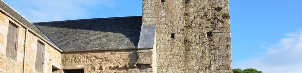
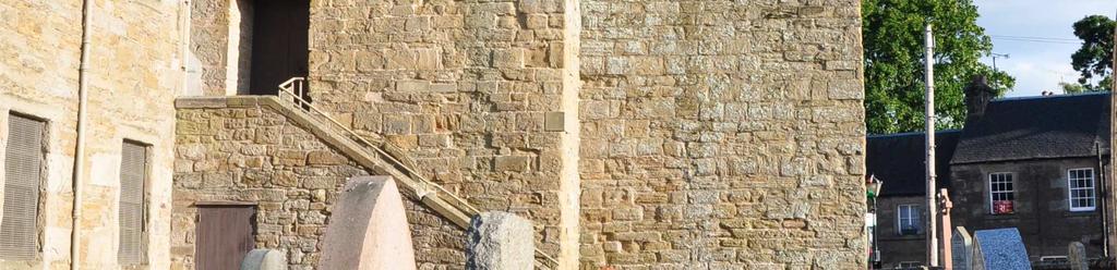
4 Summary A small trench was excavated along the north wall of the tower of St Serf s Church, Dunning. The tower was shown to be of the same date of construction as the church, as it was bonded into the nave in its lower courses. Part of the north wall of the tower re-used an earlier structure as a foundation, providing rare evidence for a pre-12th century stone building. An earlier burial running under this foundation shows earlier activity on a different alignment, presumably dating to the early medieval period. Later medieval burials were also found. Details of the construction of the medieval church were uncovered. Introduction A small trench measuring 3 x 1 metres E-W, was opened along the north wall of the tower of St Serf s church in Dunning, Perthshire (NO ). The area opened was restricted by the presence of electricity service trenches immediately to the north, and by the conditions of Scheduled Monument Consent, as the church and graveyard are a Scheduled Ancient Monument (Fig 1). The area had been a pathway not used for burial since at least c 1810 when the church was extensively remodelled and renovated. The medieval church lies at the heart of the village of Dunning, and as well as being an important Romanesque building, now houses the 9th-century Constantine s Cross, relocated from the Dupplin Estate in The trench exposed the angle of nave/tower intersection, and lay just west of the early 19thcentury stairway erected to give access to the newly built lofts in the west end and north aisle (Fig 2). This stairway originally blocked the 12th-century north door of the nave, but recent work by Historic Scotland partially removed the stairs, allowing the door to be viewed. The excavation took place during the period 20th June to 3rd July 2013, generally in good weather. Fig 1 Location of excavation at base of tower with its Romanesque belfrey opening and holes for wooden gallery. Note the19th-century loft stairway concealing the 12th-century north doorway
, but the site has a greater antiquity.")
. The square tower is one of a group in this part of eastern Scotland which includes Restenneth, Dunblane, Muthill and St Rule s in St Andrew s.")
; in 2012 a fragment of a highly decorated cross was found during SERF excavations (Gondek & Maldonado 2012); and also in 2012 another decorated fragment was identified")
5 SS13.07 Fig 2 Location of trench SS13.07, and 2012 excavations Archaeological and Historical Background St Serf s Church was first mentioned in charter sources as a possession of Inchaffray Abbey c (Fawcett 2008), but the site has a greater antiquity. The tower and mainly intact north door of the nave have architectural features dating to the early- to mid-12th-century, which is probably the date of construction of the Romanesque building (Fawcett 2008). The square tower is one of a group in this part of eastern Scotland which includes Restenneth, Dunblane, Muthill and St Rule s in St Andrew s. Evidence of earlier use of the site comes from three finds of early medieval sculpture: during the 19th century rebuilding, a late Pictish cross-slab (Fig 3) was found beneath the floor (Allen & Anderson 1903, , fig 333); in 2012 a fragment of a highly decorated cross was found during SERF excavations (Gondek & Maldonado 2012); and also in 2012 another decorated fragment was identified in the churchyard (Fig 4). These three separate sculptured stones show that Dunning was an important ecclesiastical site in the early medieval period, almost certainly a monastery. In 2007/8, excavations east of the primary school revealed a ditch which produced dates in the 7/8th centuries, suggesting that this was the outer boundary or vallum of the monastery (Cook 2008). This archaeological evidence is supplemented by the associations of the site with St Serf, generally agreed to have been active around AD 700, and whose 12th-century Life recounts a tale of a dragon slayed by him at Dunning (MacQuarrie 1993)
6 St Serf s Church, Dunning Excavations 2013 Fig 4 Newly discovered part of decorated?cross in the churchyard Fig 3 Very worn and broken graveslab of unusual double ringed-cross form of 9/10th century date. Found beneath the floor of the church in the 19th century The stone towers of which St Serf s seems to be a part have been claimed to belong to early phases of construction, and to have had specific liturgical uses, containing altars and evidence of upper external galleries (Semple 2009; cf O Keefe 2004). The present excavation was designed to address some of these issues. The tower as it stands today is approximately 5.50m square externally (note incorrect measurements in Fawcett 2008). It is built of a soft yellow sandstone of the Lower Devonian period Scone Sandstone Formation, which outcrops locally (and formed the bedrock in trenches SS13.04 and SS13.06). There was a quarry for this stone 300 metres south of the church in Dunning Park, and other exposures along Dunning Burn. The stone is easily weathered and has suffered badly from erosion, being much softer than the more normal reddish purple sandstone of this Formation. Some stonework of the church has been replaced in recent years, including some of the central shafts of the original 12th-century belfry openings (Fig 1). Aims One of the main aims of the excavation was to elucidate the history of the church tower. In particular, it was hoped to ascertain whether the tower was originally freestanding, as was the case at Dunblane (Semple 2009): and in addition to establish the date of construction. Weathering, rebuilding and re-pointing had made it impossible to be clear on the relative dates of the original nave and tower. Art-historical dating of the north doorway and tower arch suggested a 12th-century date, but as the date and function of these towers -5-
7 has been controversial (Fernie 1986, Semple 2009) it was hoped that some independent dating evidence would be found. Methodology A small trench measuring 3m x 1m was opened and excavated by hand. All contexts were recorded, and all medieval deposits were sieved. Due to the very restricted area of the trench, the presence of several burials, and the complexity of stratigraphy, the excavation was carried out solely by the author, and no students were involved in the excavation of the medieval deposits. Due to the small area and depth of the trench, it proved awkward to excavate the burials. The lower courses of the standing building, including the north door of the nave (Fig 6) were drawn at 1:10, as were all sides of the excavation trench. Mortar samples were taken for analysis and possible dating. Burials were recorded at 1:10. The deposits in the trench were not bottomed as the limit of SMC was reached. Results Removal of the tarmac and a levelling layer of stone chips and soil (4701) revealed a layer full of broken sandstone roof tiles and mortar fragments (4702). This layer contained only 18th-century pottery and glass, and probably is a levelling layer associated with the construction of a path to the stairway to the lofts. The church was originally roofed with stone tiles, and those in the tower were only replaced by slate in the 1970s. Under this layer, removal of further layers of dumped material (4703, 4704) containing building debris revealed a simple unchamfered plinth course for the nave (4708) and tower (4707). These layers produced only a few sherds of late/post medieval red and grey wares. These layers together were 0.60m thick at the east end, and 0.80m at the west end of the trench. This dumped material came off to a hard trampled surface of small pebbles mixed with charcoal and dark brown soil (4705), m m thick, which extended over the whole trench, sealing all underlying deposits. Beneath this layer was a soft crumbly brown soil (4709) up to 0.10m thick in the east, but thinning to the west. Although there was a stickier clay band about 0.1m wide along the tower wall, this did not appear to be a foundation trench, but the result of eave s drip. Removal of (4705) also revealed a new structural element (4711) at the west end of the trench. This was a lower foundation at an angle to the tower wall, formed mainly by one large (over 1 m long) block of undressed sandstone. The removal of (4709) revealed several different features, including the foundations of the church walls and medieval burials. The later medieval burials Immediately beneath 4709 skeletal remains of articulated burials were exposed. These appeared to be outlined by a soft reddish-brown soil (4712) which was interpreted initially as decayed wood of coffins, but later as the soil the graves were cut through. Two articulated skeletons were found within these grave-cuts 4715 and The eastern (grave fill 4713) was incomplete, with only the lower limbs and left arm surviving, and was of a young child (Burial 1). At a slightly lower level, and to the west, was (grave fill 4716) another young child, complete except for the upper part of the skull (Burial 2). The measured height of the child in the grave was about 0.7 m. The position of the bodies, and the shape of the grave-cuts, suggested that 4716 was the earlier of the two burials, though they have been nearly contemporary. Fragments of a skull (probably of the skeleton in 4713) were found to the north of the body, overlying the feet of 4716, and disarticulated adult bones were found in the fill of both graves. Both burials were in normal west-east supine position. However, Burial 2 had the lower legs crossed and the lower left arm crossed over the pelvic region, perhaps indicating burial in a shroud. These burials were very shallow, only a few centimetres below the surface of 4705, so it is probable that the soil they were buried in - 6 -
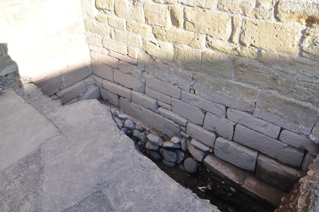
8 have been truncated, possibly when 4705 was laid down. The north sides of the graves were not exposed as they ran under the section. These burials had been inserted in deposits which turned out to be of very mixed character and full of disarticulated human remains (4725, 4728). On further excavation it became apparent that these deposits were the fill of a much deeper grave (4727) (Burial 3). This grave occupied much of the space between the foundations of the church and the northern baulk. It had not only disturbed earlier burials, but also the edge of the foundation trenches, explaining why it was difficult to see the foundation trench cuts of the 12th-century building. In addition, parts of 4012 and 4723 appeared to have fallen into the cut, confusing the stratigraphy. Because this skeleton was at such a depth, it was not fully exposed or excavated, with only a sample (tibia) being taken for radiocarbon dating. It is just possible that this skeleton in fact belongs to an earlier burial which had been exposed in the base of 4727, as the leg bones appear to run parallel to Burial 4, which is definitely early, and are partly overlain by part of 4723 (Fig 8). The grave cut 4727 was about 1.7m long, and the left side of the skeleton (SF4720) lay partly under the northern baulk. An adult skeleton with an estimated height of 1.6m (the skull was exposed at the west end) was partly exposed but not excavated as it lay below the depth limit of the trench. The position of the body was normal west-east supine, with no sign of a coffin. In the fill above the skeleton two adult femurs had been placed with their ends crossed, and there was a disarticulated skull lying over the feet. These appeared to be deliberate placements of bones disturbed during the digging of the grave. At the west end of the trench there were further mixed deposits which might represent the fill of another medieval grave or a surface - this contained two fragments of hearth bottoms from iron smelting (SF 4715). There were no other finds in any of the grave fills. The medieval church walls The main walls of the church (4706) and tower (4710) were built of identical ashlar blocks of yellow sandstone of varied height and lengths, roughly coursed. The blocks were unweathered in the area excavated, and retained details of the toolmarks (Fig 5). The toolmarks were diagonal, usually covering the whole surface in one direction, but sometimes in a diamond pattern. The chisels used appear to have been toothed. Similar diagonal toolmarks were seen on the medieval masonry (?13th century) at Forteviot church. Fig 5 Detail of toolmarks on tower plinth 4707 (above), and lack of them on early structure 4711 (below) - 7 -
9 It was immediately obvious that the tower and nave were bonded together and therefore of contemporary build. The plinths were also built of ashlar blocks, identical to those of the main walls, but of less regular size (one block was over 1.0m in length). The plinth of the tower (4707) was 0.40m high, 0.05m wide, and stepped down 0.10m at 1.20m west of the nave wall. That of the nave (4708) was also 0.40m high but had a double step, the upper part 0.09m wide, and the lower 0.05m. The ashlar of the lower of these two courses was of poorer quality. The base of both plinths was at a level of 55.10m OD, presumably the ground level when the church was built. The plinths sat on a layer of coarse brown mortar (4714) up to 0.05m thick, which projected irregularly up to 0.20m from the base of the wall and had been used to level the lowest masonry courses. This mortar looked identical to that of the lower walls and plinths of the church, and dried out to a much whiter colour. Below this mortar was a deep foundation made up of large unmortared rounded river boulders, at least 0.45m thick (4723). At the east end there was a deposit of less stony material (4724) which may also have been fill of the foundation trench but was difficult to distinguish from 4725, the fill of grave This foundation was absent in the west part of the trench under structure 4711 (Fig 6). There were no finds in any of the foundation material, except for disarticulated human remains (SFs , 4719), which had clearly been disturbed by the laying of the foundations. These bones tended to be much more decayed than those of the later medieval burials. Fig 6 Elevation drawing of south section, showing early stone feature (4711) with its different foundation material, cut by the later 12th-century boulder foundation (4723), and the early Burial 4 (4729) running underneath it. The early structure The western part of the foundation of the tower was of entirely different character to that of the rest of the church. The blocks of 4711, the lowest course, were not ashlar, and only 0.15m thick (Fig 7). They ran at angle more north of east than the tower walls (276 from grid North as opposed to 270 ), and lacked the boulder foundation of the tower and nave walls. Instead 4711 had a foundation material of grey-brown soil full of gravel and small cobbles, with fragments of sandstone (4721) (Fig 7). This filled a foundation trench (4720) about m wide and only 0.2m deep, and contained disturbed human remains (SF 4712). This material was cut by the boulders of the foundation trench of the medieval church (4723) and clearly pre-dated it. The edge of this trench continued eastwards beyond the junction of the two structures, suggesting that part of 4711 had been removed by the building of the boulder foundation The junction of the medieval plinth and foundation with the early structure was characterised by a section of jumbled stones, clearly inserted to try and match the two structures together (Figs 6, 7). There was a small patch of mortar, similar to that of the later building, under 4711, but about 0.10m lower in level. It is - 8 -
10 St Serf s Church, Dunning Excavations 2013 surprising that the weight of the tower was supported on such an insubstantial foundation, with no signs of subsidence in the overlying masonry, though the long slab of the foundation was fractured. Fig 7 The early structure 4711, showing different foundation from boulders of 4723, and jumbled stonework of intersection with plinth of tower. Note early Burial 4 (white tags) running under foundations. The early burial The medieval Burial 3, and the medieval foundation trenches, had removed almost all the earlier deposits in the trench, but a small patch was left to the north of 4711, measuring about 1.5 x 0.5 m. In this deposit an articulated burial (4729) (Burial 4) was exposed running beneath the foundations of the early structure (Fig 8). The alignment of this burial was about 250 from grid north, and was apparently of a child or young adult. The cut of the grave could not be distinguished in (4730), the soft brown soil cut by the foundation of The fill of the grave also contained disarticulated human bone (SF 4718, 4716) from earlier disturbed burials. Only the lower leg bones of Burial 4 could be excavated. There were no other finds in these early deposits. N Fig 8 General site plan showing the later medieval burial 4727 (Burial 3) with the early medieval burial 4729 (Burial 4) running under the early structure
11 Summary of burials Context SF No Description Burial Infant burial, lower half only Burial Infant burial, complete except for top of skull Burial Adult, partially excavated Burial Child, partially excavated Discussion Early medieval activity The excavations have produced certain evidence of pre-12th-century ecclesiastical activity on the site. Some sort of stone building is indicated by the re-used foundation course We can only speculate as to its original form, but its position in the tower area, which seems to be the highest point of the churchyard, might suggest that this area was a focus of sanctity before the 12th century, perhaps a building holding relics. The observation that the earlier Burial 4 is on a different alignment to this early stone building in turn suggests that there was an even earlier focus, possibly a wooden building. The fact that this early burial disturbed an even earlier one in turn suggests that this early period of burial was intensive, as seen for example at Whithorn (Hill 1997). Hopefully, radiocarbon dates will give some indication of the date and chronological span of this activity. The medieval church building One of the main results of the excavations has been the demonstration that the tower and nave are part of a single building program, conventionally dated to the mid-12th century (frontispiece). The walls were built with ashlar masonry, but not regularly coursed. The foundations were well constructed of boulders, and more substantial than the similar foundations of the 13th-century parish church excavated at Forteviot (Gondek & Maldonado 2011). The plinth is interesting as it is not decorated at all, unlike the simple chamfer at Forteviot and other local churches such as Forgandenny (Fawcett 2008). This may be a chronological difference as these other churches appear to be of 13th-century or later date. It is not clear why there was a double plinth on the west wall of the nave. The step in the plinth of the tower seems to be related to the junction with the earlier structure 4711, or else to a fall in ground level towards the west
12 St Serf s Church, Dunning Excavations 2013 Fig 9 Scale drawing of the 12th-century north doorway The north door of the nave (Fig 9), measuring 0.9 x 2.2 m, was rather tall and narrow, like the very similar door at Abercorn, and like it may have had a tympanum originally. If the ground level revealed in the west wall continued along the north wall, there must have been one or probably two steps up to the threshold. The bases of the nook-shaft pillars had been damaged during removal of the shafts, deliberated chipped off. However, enough of the west one survives to show it had a simple convex form, interestingly not mirroring the cushion capitals of the east shaft, but similar to that at Abercorn (Fawcett 2008). This is the first measured drawing of the door, as it was not accessible when the Royal Commission surveyed the site. Late/Post-Medieval graves The area of the trench was chosen to avoid areas containing modern burials of 17th-20th century date. The two infant burials (Burials 1 and 2) are interesting in their placement along the north wall of the church building, generally an unfavoured side in the medieval period, and apparent burial in shrouds rather than coffins. There are similarities to the postreformation child burials at Inchmarnock (Lowe 2008, 90-6) though these were mainly on the south side of the church. They may be unbaptised burials. The underlying adult grave Burial 3 was placed as close as possible to the church walls, perhaps indicating that the tower was an especially sanctified area, and that this was a medieval burial. The careful placement within the grave of the crossed longbones and skull belonging to a previous burial
13 call to mind the skull and crossbones motif of post-medieval gravestones, but early medieval examples of similar practices are known (James and Yeoman 2008, 30). Late/post-medieval deposits Much of the post-medieval levelling deposits may have been put in place during the extensive remodelling of the church in the early years of the 19th century. However, a newly identified datestone of 1750 in the north wall of the chancel, shows that not all the remodelling was of this date. The protection of the lower courses of masonry by these deposits shows that the severe erosion of the exterior walls has mainly taken place in the last few hundred years, presumably as the result of acid rain pollution from the Central Belt industrial development. Conclusions Despite the very restricted nature of the excavations, the main research questions have been answered. The tower and nave are definitely of one build; there is an earlier stone structure on the site; and earlier burials will give dating for the first ecclesiastic activity on the site. An early medieval focus under the present church has been identified, confirming the evidence from historical source, the vallum excavation, and sculptured stones, that this was an important early medieval site. In addition, new details of the Romanesque church have been revealed, including the preservation of a simple plinth and toolmarked ashlar. Acknowledgements Particular thanks are due to the Historic Scotland custodians for constant support. Members of the Dunning Historical Society gave much local information and support. The project was partly sponsored by the British Academy (LRG: 45610); Historic Scotland (Archaeology Funding Programme) and the Universities of Glasgow and Aberdeen. The research of SERF is benefited by partnerships with the Royal Commission on the Ancient and Historical Monuments of Scotland ( and Perth and Kinross Heritage Trust ( References Allen, JR & Anderson, J 1903 The early Christian monuments of Scotland: a classified illustrated descriptive list of the monuments with an analysis of their symbolism and ornamentation, vol. 3, Edinburgh. Cook, M 2008 An Early Christian vallum in Dunning? Tayside and Fife Archaeological Journal 14, Fawcett, R 2008 A corpus of Scottish medieval parish churches. Fernie, E 1986 Early church architecture in Scotland, Proc Soc Antiq Scot 116, Gondek,M & Maldonado, A 2011 Forteviot churchyard excavations University of Glasgow Gondek, M & Maldonado, A 2012 Kirk Wynd and Castle Cottage, Dunning Excavation University of Glasgow Hall, M (2011). Tales from beyond the Pict: sculpture and its uses in and around Forteviot, Perthshire from the ninth century onwards. Pictish Progress: New Studies on Northern Britain in the Early Middle Ages. S. T. Driscoll, J. Geddes and M. Hall. Leiden, Brill: Hill, P 1997 Whithorn & St Ninian. The excavation of a monastic town, Stroud
14 James, H & Yeoman, P 2008 Excavations at St Ethernan s monastery, Isle of May, Fife Perth: Tayside and Fife Archaeological Committee Monograph 6. Lowe, C 2008 Inchmarnock: an early historic island monastery and its archaeological landscape. Edinburgh; Society of Antiquaries Scotland Monograph MacQuarrie, A 1993 Vita sancti servani : the life of St Serf. Innes Review, 44 (2): O'Keeffe, T 2004 Ireland's Round Towers. Buildings, Rituals and Landscapes of the Early Irish Church. Stroud: Tempus. Semple, M C 2009 An archaeology of Scotland s the early Romanesque churches: the towers of Alba. Unpublished PhD thesis, University of Glasgow
15 Appendices i) Contexts 4701 Deposit Tarmac and hardcore ENC Deposit mixed deposit with stone roof tiles ENC Deposit reddish brown sticky clay with boulders and cobbles ENC Deposit similar to 4703, but less sticky, more mortar, less big stones ENC Deposit hard packed soil and stones with charcoal ENC Structure West wall of church nave ENC Structure ashlar blocks two courses high, less fine than 4710 (plinth) ENC Structure two courses of ashlar blocks (plinth) ENC Deposit loose crumbly dark brown soil, occ. small stones. along 4707 sticky clay with stones ENC Structure north wall of church tower ENC Structure Early wall beneath tower ENC Deposit red-brown soft soil ENC Fill Loose grey-brown silt with grit ENC Deposit brown lime mortar layer ENC Cut subrectangular trench (grave) ENC Fill same as 4713 ENC Cut sub-rectangular pit (grave) ENC Fill Not used ENC Cut Not used ENC Cut linear feature (foundation trench) ENC Fill loose mixed grey-brown soil with pebbles and cobble-sized rocks (foundation) ENC Cut linear feature (foundation trench) ENC Fill Large rounded boulders (foundation) ENC Deposit loose brown soil very mixed inclusions ENC Fill loose brown soil with stone/pebbles and human bone ENC Deposit Hard gravelly layer with charcoal, sandstone fragments etc. ENC Cut sub-rectangular cut (grave) ENC Fill as 4725 ENC Fill soft brown soil, few inclusions ENC Deposit soft brown soil as 4729 ENC ii) Small Finds SF No Context Feature Type Material Descript. No. Piece E N Z Initial Date deposit pottery deposit pottery Handle, green glazed med ENC 20/6/13 Redware med ENC 20/6/ deposit pottery medieval ENC 20/6/ deposit pottery White gritty ware ENC 22/6/ deposit VFAS ENC 22/6/
16 deposit bone Disart. mixed JL 23/6/ Grave fill bone Child skeleton ENC 27/6/ ? Grave fill bone ENC 27/6/ Grave fill bone Child skeleton ENC 27/6/ Grave fill bone Disartic. ENC 27/6/ Foundatio 4721 n trench bone Disartic ENC 27/6/ Foundatio 4721 n trench bone Disartic ENC 27/6/ Foundatio 4723 n trench charcoal ENC 29/6/ Foundatio 4723 n trench bone Epiphysis disart ENC 29/6/ deposit Iron slag Hearth bases ENC 29/6/ Grave fill bone Skull disart ENC 1/7/ Grave fill bone Artic. tibia and fibula ENC 1/7/ Grave fill bone Femur disartic ENC 1/7/ Foundatio 4723 n trench bone Arm (artic.) ENC 1/7/ Grave fill bone Skeleton (partially excavated ). femur ENC 1/7/13 iii) Drawings Drawing Type Scale Description Main Contexts Initials Date No Plan 1:20 Site plan 4703 ENC 18/6/ Elevation 1:10 Lower part of Norman doorway ENC 20/6/ Plan 1:10 Base of Norman doorway ENC 20/6/ Plan 1:20 After removal of ENC 23/6/ Elevation 1;20 North face of tower 4705, 4707, 4711, ERV, 23/6/ , 4721, 4729 ENC 4515 Plan 1:20 Child burials 4713, 4716 ENC 24/6/ Plan 1:10 Upper child burial 4715, 4713 ENC 24/6/ Plan 1: , 4713 after removal 0f ENC 24/6/ Plan 1:10 Lower child burial 4717, 4716 ENC 27/6/ Elevation 1:20 West wall of nave 4706, 4708, 4725 ERV 2/7/ Section 1:10 West face of trench 4721, 4711, ENC 2/7/ Plan 1:20 Early burials ENC 1/7/ Plan 1:20 Foundation trench of ENC 28/6/ Plan 1:20 Med burial early stage of excavation 4727 ENC 1/7/ Section 1:10 North face of trench 4727, 4723 ENC 3/7/13 v) Photos
17 Digital photo_frame taken_by taken_on description taken_from SS13.07_4214 ENC 17/06/2013 plan view of trench pre-ex North SS13.07_4215 ENC 17/06/2013 plan view of trench pre-ex West SS13.07_4216 ENC 17/06/2013 trench location in context West SS13.07_4237 ENC Top of 4703 after removal of roof tiles 18/06/ West SS13.07_4238 ENC Top of 4703 after removal of roof tiles 18/06/ East SS13.07_4272 ENC St Serf's, Tower, N Doorway : Column 20/06/2013 base SS13.07_4273 ENC St Serf's, Tower, N Doorway : E Jamb 20/06/2013 and base SS13.07_4274 ENC St Serf's, Tower, N Doorway, Column 20/06/2013 base SS13.07_4275 ENC 20/06/2013 St Serf's, Tower, N Doorway, Threshold SS13.07_4276 ENC 20/06/2013 St Serf's, Tower, N Doorway, Threshold SS13.07_4277 ENC 20/06/2013 St Serf's, Tower, N Doorway, Threshold North SS13.07_4278 ENC 20/06/2013 St Serf's, Tower, N Doorway, Threshold North SS13.07_4279 ENC St Serf's, Tower, N Doorway, E jamb 20/06/2013 and base West SS13.07_4374 ENC 28/06/2013 Grave cuts post -ex West SS13.07_4375 ENC 28/06/2013 Grave cuts post -ex North SS13.07_4376 ENC 28/06/2013 Grave cuts post -ex East SS13.07_4377 ENC 28/06/2013 Grave cut post ex East SS13.07_4378 ENC 28/06/2013 Grave cuts post ex East West SS13.07_4379 ENC Foundation trench & early structure 28/06/ Northwest SS13.07_4380 ENC Foundation trench & early structure 28/06/ North SS13.07_4381 ENC Foundation trench & early structure 28/06/ North SS13.07_4382 ENC Foundation trench & early structure 28/06/ West SS13.07_4383 ENC 28/06/2013 Bone in foundation trench West SS13.07_4431 ENC 02/07/2013 General post-ex shots SS13.07_4432 ENC 02/07/2013 General post-ex shots SS13.07_4433 ENC 02/07/2013 General post-ex shots SS13.07_4434 ENC 02/07/2013 General post-ex shots SS13.07_4435 ENC 02/07/2013 General post-ex shots SS13.07_4436 ENC 02/07/2013 General post-ex shots SS13.07_4437 ENC 02/07/2013 General post-ex shots SS13.07_4438 ENC 02/07/2013 General post-ex shots SS13.07_4439 ENC 02/07/2013 General post-ex shots SS13.07_4440 ENC 02/07/2013 General post-ex shots SS13.07_4441 ENC 02/07/2013 General post-ex shots
18 SS13.07_4442 ENC SS13.07_4443 ENC SS13.07_4445 CTW SS13.07_4446 ENC 02/07/2013 General post-ex shots 02/07/2013 General post-ex shots 02/07/2013 General post-ex shots 02/07/2013 General post-ex shots
Greater London GREATER LONDON 3/606 (E ) TQ
 TQ") GREATER LONDON City of London 3/606 (E.01.6024) TQ 30358150 1 PLOUGH PLACE, CITY OF LONDON An Archaeological Watching Brief at 1 Plough Place, City of London, London EC4 Butler, J London : Pre-Construct
GREATER LONDON City of London 3/606 (E.01.6024) TQ 30358150 1 PLOUGH PLACE, CITY OF LONDON An Archaeological Watching Brief at 1 Plough Place, City of London, London EC4 Butler, J London : Pre-Construct
THE PRE-CONQUEST COFFINS FROM SWINEGATE AND 18 BACK SWINEGATE
 THE PRE-CONQUEST COFFINS FROM 12 18 SWINEGATE AND 18 BACK SWINEGATE An Insight Report By J.M. McComish York Archaeological Trust for Excavation and Research (2015) Contents 1. INTRODUCTION... 3 2. THE
TIPPERARY HISTORICAL JOURNAL 1994
 TPPERARY HSTORCAL JOURNAL 1994 County Tipperary Historical Society www.tipperarylibraries.ie/ths society@tipperarylibraries. ie SSN 0791-0655 Excavations at Cormac's Chapel, Cashel, 1992 and 1993: a preliminary
1 The East Oxford Archaeology and History Project
 1 The East Oxford Archaeology and History Project EXOP TEST PIT 72 Location: Bartlemas Chapel, Cowley Date of excavation: 6-8 November 2013. Area of excavation: 0.8m x 1.2m, at the eastern end of the chapel.
An archaeological evaluation in the playground of Colchester Royal Grammar School, Lexden Road, Colchester, Essex
 An archaeological evaluation in the playground of Colchester Royal Grammar School, Lexden Road, Colchester, Essex February 2002 on behalf of Roff Marsh Partnership CAT project code: 02/2c Colchester Museum
An archaeological watching brief and recording at Brightlingsea Quarry, Moverons Lane, Brightlingsea, Essex October 2003
 An archaeological watching brief and recording at Brightlingsea Quarry, Moverons Lane, Brightlingsea, Essex commissioned by Mineral Services Ltd on behalf of Alresford Sand & Ballast Co Ltd report prepared
Test-Pit 3: 31 Park Street (SK )
") -Pit 3: 31 Park Street (SK 40732 03178) -Pit 3 was excavated in a flower bed in the rear garden of 31 Park Street, on the northern side of the street and west of an alleyway leading to St Peter s Church,
-Pit 3: 31 Park Street (SK 40732 03178) -Pit 3 was excavated in a flower bed in the rear garden of 31 Park Street, on the northern side of the street and west of an alleyway leading to St Peter s Church,
Church of St Peter and St Paul, Great Missenden, Buckinghamshire
 Church of St Peter and St Paul, Great Missenden, Buckinghamshire An Archaeological Watching Brief for the Parish of Great Missenden by Andrew Taylor Thames Valley Archaeological Services Ltd Site Code
39, Walnut Tree Lane, Sudbury (SUY 073) Planning Application No. B/04/02019/FUL Archaeological Monitoring Report No. 2005/112 OASIS ID no.
 Planning Application No. B/04/02019/FUL Archaeological Monitoring Report No. 2005/112 OASIS ID no.") 39, Walnut Tree Lane, Sudbury (SUY 073) Planning Application No. B/04/02019/FUL Archaeological Monitoring Report No. 2005/112 OASIS ID no. 9273 Summary Sudbury, 39, Walnut Tree Lane, Sudbury (TL/869412;
39, Walnut Tree Lane, Sudbury (SUY 073) Planning Application No. B/04/02019/FUL Archaeological Monitoring Report No. 2005/112 OASIS ID no. 9273 Summary Sudbury, 39, Walnut Tree Lane, Sudbury (TL/869412;
2 Saxon Way, Old Windsor, Berkshire
 2 Saxon Way, Old Windsor, Berkshire An Archaeological Watching Brief For Mrs J. McGillicuddy by Pamela Jenkins Thames Valley Archaeological Services Ltd Site Code SWO 05/67 August 2005 Summary Site name:
An archaeological evaluation at the Blackwater Hotel, Church Road, West Mersea, Colchester, Essex March 2003
 An archaeological evaluation at the Blackwater Hotel, Church Road, West Mersea, Colchester, Essex report prepared by Laura Pooley on behalf of Dolphin Developments (U.K) Ltd NGR: TM 0082 1259 CAT project
Moray Archaeology For All Project
 School children learning how to identify finds. (Above) A flint tool found at Clarkly Hill. Copyright: Leanne Demay Moray Archaeology For All Project ational Museums Scotland have been excavating in Moray
FURTHER MIDDLE SAXON EVIDENCE AT COOK STREET, SOUTHAMPTON (SOU 567)
") Roc. Hampshire Field Club Archaeol. Soc 52,1997, 77-87 (Hampshire Studies 1997) FURTHER MIDDLE SAXON EVIDENCE AT COOK STREET, SOUTHAMPTON (SOU 567) By M F GARNER andj VINCENT with a contribution byjacqueline
Roc. Hampshire Field Club Archaeol. Soc 52,1997, 77-87 (Hampshire Studies 1997) FURTHER MIDDLE SAXON EVIDENCE AT COOK STREET, SOUTHAMPTON (SOU 567) By M F GARNER andj VINCENT with a contribution byjacqueline
ST PATRICK S CHAPEL, ST DAVIDS PEMBROKESHIRE 2015
 ST PATRICK S CHAPEL, ST DAVIDS PEMBROKESHIRE 2015 REPORT FOR THE NINEVEH CHARITABLE TRUST THE UNIVERSITY OF SHEFFIELD AND DYFED ARCHAEOLOGICAL TRUST Introduction ST PATRICK S CHAPEL, ST DAVIDS, PEMBROKESHIRE,
Monitoring Report No. 99
 Monitoring Report No. 99 Enniskillen Castle Co. Fermanagh AE/06/23 Cormac McSparron Site Specific Information Site Name: Townland: Enniskillen Castle Enniskillen SMR No: FER 211:039 Grid Ref: County: Excavation
Chapter 2. Remains. Fig.17 Map of Krang Kor site
 Chapter 2. Remains Section 1. Overview of the Survey Area The survey began in January 2010 by exploring the site of the burial rootings based on information of the rooted burials that was brought to the
3. The new face of Bronze Age pottery Jacinta Kiely and Bruce Sutton
 3. The new face of Bronze Age pottery Jacinta Kiely and Bruce Sutton Illus. 1 Location map of Early Bronze Age site at Mitchelstown, Co. Cork (based on the Ordnance Survey Ireland map) A previously unknown
Forteviot Pictish Cemetery Excavation Data Structure Report. By Ewan Campbell
 Forteviot Pictish Cemetery Excavation 2010 Data Structure Report By Ewan Campbell Table of Contents Summary 2 Introduction 2 Aims 2 Methodology 2 Results 4 Geology 4 Post-Cemetery Agricultural Activity
An archaeological watching brief at St Leonard s church, Hythe Hill, Colchester, Essex
 An archaeological watching brief at St Leonard s church, Hythe Hill, Colchester, Essex report prepared by Adam Wightman on behalf of Dorvell Construction CAT project ref.: 10/5d Colchester and Ipswich
Oxfordshire. Wallingford. St Mary-le-More. Archaeological Watching Brief Report. Client: JBKS Architects and St Mary s Renewal Campaign.
 St Mary-le-More Wallingford Oxfordshire Archaeological Watching Brief Report February 2010 Client: JBKS Architects and St Mary s Renewal Campaign Issue No:1 OA Job No: 4432 NGR: SU 6071 8933 Archaeological
Peace Hall, Sydney Town Hall Results of Archaeological Program (Interim Report)
") Results of Archaeological Program (Interim Report) Background The proposed excavation of a services basement in the western half of the Peace Hall led to the archaeological investigation of the space in
Results of Archaeological Program (Interim Report) Background The proposed excavation of a services basement in the western half of the Peace Hall led to the archaeological investigation of the space in
New Composting Centre, Ashgrove Farm, Ardley, Oxfordshire
 New Composting Centre, Ashgrove Farm, Ardley, Oxfordshire An Archaeological Watching Brief For Agrivert Limited by Andrew Weale Thames Valley Archaeological Services Ltd Site Code AFA 09/20 August 2009
A visit to the Wor Barrow 21 st November 2015
 A visit to the Wor Barrow 21 st November 2015 Following our exploration of Winkelbury a few weeks previously, we fast forwarded 12 years in Pitt Rivers remarkable series of excavations and followed him
An archaeological evaluation at 16 Seaview Road, Brightlingsea, Essex February 2004
 An archaeological evaluation at 16 Seaview Road, Brightlingsea, Essex February 2004 report prepared by Kate Orr on behalf of Highfield Homes NGR: TM 086 174 (c) CAT project ref.: 04/2b ECC HAMP group site
Cambridge Archaeology Field Group. Fieldwalking on the Childerley Estate, Cambridgeshire. Autumn 2014 to Spring Third interim report
 Cambridge Archaeology Field Group Fieldwalking on the Childerley Estate, Cambridgeshire Autumn 2014 to Spring 2015 Third interim report Summary Field walking on the Childerley estate of Martin Jenkins
7. Prehistoric features and an early medieval enclosure at Coonagh West, Co. Limerick Kate Taylor
 7. Prehistoric features and an early medieval enclosure at Coonagh West, Co. Limerick Kate Taylor Illus. 1 Location of the site in Coonagh West, Co. Limerick (based on the Ordnance Survey Ireland map)
KINNEIL OLD CHURCH CROSS
 Property in Care (PIC) ID: PIC153 Designations: N/A Taken into State care: 1968 (Guardianship) Last reviewed: 2017 HISTORIC ENVIRONMENT SCOTLAND STATEMENT OF SIGNIFICANCE KINNEIL OLD CHURCH CROSS We continually
ARCHAEOLOGICAL S E R V I C E S. St Nicholas' Church, Barrack Hill, Nether Winchendon, Buckinghamshire. Archaeological Watching Brief.
 T H A M E S V A L L E Y ARCHAEOLOGICAL S E R V I C E S St Nicholas' Church, Barrack Hill, Nether Winchendon, Buckinghamshire Archaeological Watching Brief by Steven Crabb Site Code: STW17/229 (SP 7735
Erection of wind turbine, Mains of Loanhead, Old Rayne, AB52 6SX
 Erection of wind turbine, Mains of Loanhead, Old Rayne, AB52 6SX Ltd 23 November 2011 Erection of wind turbine, Mains of Loanhead, Old Rayne, AB52 6SX CONTENTS 1 INTRODUCTION 3 2 ARCHAEOLOGICAL BACKGROUND
ABERNETHY ROUND TOWER
 Property in Care(PIC) ID: PIC004 Designations: Scheduled Monument (SM90005); Listed Building (LB20875, Category A) Taken into State care: 1929 (Guardianship) Last reviewed: 2015 HISTORIC ENVIRONMENT SCOTLAND
NOTE A THIRD CENTURY ROMAN BURIAL FROM MANOR FARM, HURSTBOURNE PRIORS. by. David Allen with contributions by Sue Anderson and Brenda Dickinson
 Proc. Hampsh. Field Club Archaeol. Soc. 47, 1991, 253-257 NOTE A THIRD CENTURY ROMAN BURIAL FROM MANOR FARM, HURSTBOURNE PRIORS Abstract by. David Allen with contributions by Sue Anderson and Brenda Dickinson
An archaeological evaluation at the Lexden Wood Golf Club (Westhouse Farm), Lexden, Colchester, Essex
, Lexden, Colchester, Essex") An archaeological evaluation at the Lexden Wood Golf Club (Westhouse Farm), Lexden, Colchester, Essex January 2000 Archive report on behalf of Lexden Wood Golf Club Colchester Archaeological Trust 12 Lexden
An archaeological evaluation at the Lexden Wood Golf Club (Westhouse Farm), Lexden, Colchester, Essex January 2000 Archive report on behalf of Lexden Wood Golf Club Colchester Archaeological Trust 12 Lexden
Tell Shiyukh Tahtani (North Syria)
") Tell Shiyukh Tahtani (North Syria) Report of the 2010 excavation season conducted by the University of Palermo Euphrates Expedition by Gioacchino Falsone and Paola Sconzo In the summer 2010 the University
Tell Shiyukh Tahtani (North Syria) Report of the 2010 excavation season conducted by the University of Palermo Euphrates Expedition by Gioacchino Falsone and Paola Sconzo In the summer 2010 the University
Grim s Ditch, Starveall Farm, Wootton, Woodstock, Oxfordshire
 Grim s Ditch, Starveall Farm, Wootton, Woodstock, Oxfordshire An Archaeological Recording Action For Empire Homes by Steve Ford Thames Valley Archaeological Services Ltd Site Code SFW06/118 November 2006
WESTSIDE CHURCH (TUQUOY)
") Property in Care (PIC) ID: PIC324 Designations: Scheduled Monument (SM90312) Taken into State care: 1933 (Guardianship) Last reviewed: 2004 HISTORIC ENVIRONMENT SCOTLAND STATEMENT OF SIGNIFICANCE WESTSIDE
Property in Care (PIC) ID: PIC324 Designations: Scheduled Monument (SM90312) Taken into State care: 1933 (Guardianship) Last reviewed: 2004 HISTORIC ENVIRONMENT SCOTLAND STATEMENT OF SIGNIFICANCE WESTSIDE
Evidence for the use of bronze mining tools in the Bronze Age copper mines on the Great Orme, Llandudno
 Evidence for the use of bronze mining tools in the Bronze Age copper mines on the Great Orme, Llandudno Background The possible use of bronze mining tools has been widely debated since the discovery of
THE RAVENSTONE BEAKER
 DISCOVERY THE RAVENSTONE BEAKER K. J. FIELD The discovery of the Ravenstone Beaker (Plate Xa Fig. 1) was made by members of the Wolverton and District Archaeological Society engaged on a routine field
CONSERVATION OF THE RIEVALLEN STONE, CHURCH OF ST MARY S, RIEVAULX, NORTH YORKSHIRE
 CONSERVATION OF THE RIEVALLEN STONE, CHURCH OF ST MARY S, RIEVAULX, NORTH YORKSHIRE Nigel Copsey for Peter Pace, March 2007 St Mary s church, Rievaulx was originally a Gate Chapel for the Abbey below,
Colchester Archaeological Trust Ltd. A Fieldwalking Survey at Birch, Colchester for ARC Southern Ltd
 Colchester Archaeological Trust Ltd A Fieldwalking Survey at Birch, Colchester for ARC Southern Ltd November 1997 CONTENTS page Summary... 1 Background... 1 Methods... 1 Retrieval Policy... 2 Conditions...
KEILLS CHAPEL AND CROSS
 Property in Care (PIC) ID: PIC078 Designations: Scheduled Monument (SM90176); Taken into State care: 1972 (Guardianship) Last reviewed: 2004 HISTORIC ENVIRONMENT SCOTLAND STATEMENT OF SIGNIFICANCE KEILLS
1. Presumed Location of French Soundings Looking NW from the banks of the river.
 SG02? SGS SG01? SG4 1. Presumed Location of French Soundings Looking NW from the banks of the river. The presumed location of SG02 corresponds to a hump known locally as the Sheikh's tomb. Note also (1)
Former Whitbread Training Centre Site, Abbey Street, Faversham, Kent Interim Archaeological Report Phase 1 November 2009
 Former Whitbread Training Centre Site, Abbey Street, Faversham, Kent Interim Archaeological Report Phase 1 November 2009 SWAT. Archaeology Swale and Thames Archaeological Survey Company School Farm Oast,
Fort Arbeia and the Roman Empire in Britain 2012 FIELD REPORT
 Fort Arbeia and the Roman Empire in Britain 2012 FIELD REPORT Background Information Lead PI: Paul Bidwell Report completed by: Paul Bidwell Period Covered by this report: 17 June to 25 August 2012 Date
Human remains from Estark, Iran, 2017
 Bioarchaeology of the Near East, 11:84 89 (2017) Short fieldwork report Human remains from Estark, Iran, 2017 Arkadiusz Sołtysiak *1, Javad Hosseinzadeh 2, Mohsen Javeri 2, Agata Bebel 1 1 Department of
17 Phase 5. High and Late medieval features and activities AD
 17 Phase 5. High and Late medieval features and activities 1200 1550 AD 17.1 Results This time phase is based on all findings that can be placed in the High and Late medieval period 1200 1550 AD based
Cetamura Results
 Cetamura 2000 2006 Results A major project during the years 2000-2006 was the excavation to bedrock of two large and deep units located on an escarpment between Zone I and Zone II (fig. 1 and fig. 2);
Forteviot, Palisaded Enclosure Excavations Data Structure Report. By Aoife Gould
 Forteviot, Palisaded Enclosure Excavations 2010 Data Structure Report By Aoife Gould Table of Contents Summary 2 Introduction 2 Location 2 Archaeological Background 4 Aims 4 Methodology 5 Results 8 Subsoil
Data Structure Report: Boho High Cross, Toneel North, Co. Fermanagh
 Data Structure Report: Boho High Cross, Toneel North, Co. Fermanagh Colm Donnelly, Philip Macdonald, Eileen Murphy and Nicholas Beer SMR No: Ferm 210:14 Grid Reference: H1167 4621 Excavation Licence: AE/02/49
MARSTON MICHAEL FARLEY
 MARSTON MICHAEL FARLEY On 9 March agricultural contractors, laying field drains for Bucks County Council Land Agent's Department, cut through a limestone structure at SP 75852301 in an area otherwise consistently
January 13 th, 2019 Sample Current Affairs
 January 13 th, 2019 Sample Current Affairs 1. Harappa grave of ancient 'couple' reveals secrets of Marriage What are the key takeaways of the excavation? Was marriage legally accepted in Harappan society?
Control ID: Years of experience: Tools used to excavate the grave: Did the participant sieve the fill: Weather conditions: Time taken: Observations:
 Control ID: Control 001 Years of experience: No archaeological experience Tools used to excavate the grave: Trowel, hand shovel and shovel Did the participant sieve the fill: Yes Weather conditions: Flurries
A COIN OF OFFA FOUND IN A VIKING-AGE BURIAL AT VOSS, NORWAY. Bergen Museum.
 A COIN OF OFFA FOUND IN A VIKING-AGE BURIAL AT VOSS, NORWAY. BY HAAKON SCHETELIG, Doct. Phil., Curator of the Bergen Museum. Communicated by G. A. AUDEN, M.A., M.D., F.S.A. URING my excavations at Voss
St Germains, Tranent, East Lothian: the excavation of Early Bronze Age remains and Iron Age enclosed and unenclosed settlements
 Proc Soc Antiq Scot, 128 (1998), 203-254 St Germains, Tranent, East Lothian: the excavation of Early Bronze Age remains and Iron Age enclosed and unenclosed settlements Derek Alexander* & Trevor Watkinsf
Scotland possesses a remarkable
 CARVED STONES The Picts carved unique symbols that were not just decorative but conveyed a message, although the meaning is now lost to us. Crown copyright: Historic Scotland houses, in both cases dating
ARCHAEOLOGICAL MONITORING REPORT
 ARCHAEOLOGICAL MONITORING REPORT SCCAS REPORT No. 2009/324 Thorington Hall, Stoke by Nayland SBN 087 HER Information Date of Fieldwork: November 2009 - January 2010 Grid Reference: TM 0131 3546 Funding
Archaeological. Monitoring & Recording Report. Fulbourn Primary School, Cambridgeshire. Archaeological Monitoring & Recording Report.
 Fulbourn Primary School, Cambridgeshire Archaeological Monitoring & Recording Report October 2014 Client: Cambridgeshire County Council OA East Report No: 1689 OASIS No: oxfordar3-192890 NGR: TL 5190 5613
AN EARLY MEDIEVAL RUBBISH-PIT AT CATHERINGTON, HAMPSHIRE Bj>J. S. PILE and K. J. BARTON
 AN EARLY MEDIEVAL RUBBISH-PIT AT CATHERINGTON, HAMPSHIRE Bj>J. S. PILE and K. J. BARTON INTRODUCTION THE SITE (fig. 21) is situated in the village of Catherington, one mile north-west of Horndean and 200
Suburban life in Roman Durnovaria
 Suburban life in Roman Durnovaria Additional specialist report Finds Ceramic building material By Kayt Brown Ceramic building material (CBM) Kayt Brown A total of 16420 fragments (926743g) of Roman ceramic
Chapel House Wood Landscape Project. Interim Report 2013
 Chapel House Wood Landscape Project Interim Report 2013 Chapel House Wood Landscape Project Interim Report 2013 The annual Dales Heritage Field School was held at Chapel House Wood again this year, and
Fieldwalking at Cottam 1994 (COT94F)
") Fieldwalking at Cottam 1994 (COT94F) Tony Austin & Elizabeth Jelley (19 Jan 29) 1. Introduction During the winter of 1994 students from the Department of Archaeology at the University of York undertook
Fieldwalking at Cottam 1994 (COT94F) Tony Austin & Elizabeth Jelley (19 Jan 29) 1. Introduction During the winter of 1994 students from the Department of Archaeology at the University of York undertook
Excavations at Shikarpur, Gujarat
 Excavations at Shikarpur, Gujarat 2008-2009 The Department of Archaeology and Ancient History, the M. S. University of Baroda continued excavations at Shikarpur in the second field season in 2008-09. In
Information for Teachers
 Sueno s Stone in Forres is the tallest carved stone in Scotland and shows a dramatic battle scene. Investigating Sueno s Stone Information for Teachers education investigating historic sites 2 Sueno s
Archaeological Watching Brief (Phase 2) at Court Lodge Farm, Aldington, near Ashford, Kent December 2011
 at Court Lodge Farm, Aldington, near Ashford, Kent December 2011") Archaeological Watching Brief (Phase 2) at Court Lodge Farm, Aldington, near Ashford, Kent December 2011 SWAT. Archaeology Swale and Thames Archaeological Survey Company School Farm Oast, Graveney Road
Archaeological Watching Brief (Phase 2) at Court Lodge Farm, Aldington, near Ashford, Kent December 2011 SWAT. Archaeology Swale and Thames Archaeological Survey Company School Farm Oast, Graveney Road
The Upper Sabina Tiberina Project: Report for the Archaeological Institute of America Rutgers University Newark
 The Upper Sabina Tiberina Project: Report for the Archaeological Institute of America Rutgers University Newark My archeological dig took place near the village of Vacone, a small town on the outskirts
Greater London Region GREATER LONDON 3/567 (E.01.K099) TQ BERMONDSEY STREET AND GIFCO BUILDING AND CAR PARK
 TQ BERMONDSEY STREET AND GIFCO BUILDING AND CAR PARK") GREATER LONDON 3/567 (E.01.K099) TQ 33307955 156-170 BERMONDSEY STREET AND GIFCO BUILDING AND CAR PARK Assessment of an Archaeological Excavation at 156-170 Bermondsey Street and GIFCO Building and Car
GREATER LONDON 3/567 (E.01.K099) TQ 33307955 156-170 BERMONDSEY STREET AND GIFCO BUILDING AND CAR PARK Assessment of an Archaeological Excavation at 156-170 Bermondsey Street and GIFCO Building and Car
ARCHAEOLOGICAL EVALUATION AT BRIGHTON POLYTECHNIC, NORTH FIELD SITE, VARLEY HALLS, COLDEAN LANE, BRIGHTON. by Ian Greig MA AIFA.
 ARCHAEOLOGICAL EVALUATION AT BRIGHTON POLYTECHNIC, NORTH FIELD SITE, VARLEY HALLS, COLDEAN LANE, BRIGHTON by Ian Greig MA AIFA May 1992 South Eastern Archaeological Services Field Archaeology Unit White
STONES OF STENNESS HISTORIC ENVIRONMENT SCOTLAND STATEMENT OF SIGNIFICANCE
 Property in Care (PIC) ID: PIC321 Designations: Scheduled Monument (SM90285); Taken into State care: 1906 (Guardianship) Last reviewed: 2003 HISTORIC ENVIRONMENT SCOTLAND STATEMENT OF SIGNIFICANCE STONES
Silwood Farm, Silwood Park, Cheapside Road, Ascot, Berkshire
 Silwood Farm, Silwood Park, Cheapside Road, Ascot, Berkshire An Archaeological Watching Brief For Imperial College London by Tim Dawson Thames Valley Archaeological Services Ltd Site Code SFA 09/10 April
16 members of the Fieldwalking Group met York Community Archaeologist Jon Kenny at Lou Howard s farm, Rose Cottage Farm, at
 Terrington History Group Fieldwalking Group Field 1 Final report 21 October 2011 - fieldwalking 16 members of the Fieldwalking Group met York Community Archaeologist Jon Kenny at Lou Howard s farm, Rose
INCHKENNETH CHAPEL HISTORIC ENVIRONMENT SCOTLAND STATEMENT OF SIGNIFICANCE. Property in Care (PIC) ID: PIC072
 ID: PIC072") Property in Care (PIC) ID: PIC072 Designations: Scheduled Monument (SM90168) Taken into State care: 1928 (Guardianship) Last reviewed: 2004 HISTORIC ENVIRONMENT SCOTLAND STATEMENT OF SIGNIFICANCE INCHKENNETH
Property in Care (PIC) ID: PIC072 Designations: Scheduled Monument (SM90168) Taken into State care: 1928 (Guardianship) Last reviewed: 2004 HISTORIC ENVIRONMENT SCOTLAND STATEMENT OF SIGNIFICANCE INCHKENNETH
198 S. ALBANS AND HERTS ARCHITECTURAL AND ARCHAEOLOGICAL SOCIETY. REPORT FOR BY WILLIAM PAGE, F.S.A.
 198 S. ALBANS AND HERTS ARCHITECTURAL AND ARCHAEOLOGICAL SOCIETY. REPORT FOR 1898-9. BY WILLIAM PAGE, F.S.A. It is difficult for those who have made no study of the Roman occupation of this country to
AREA C. HENRY 0. THOMPSON American Center of Oriental Research Amman, Jordan
 AREA C HENRY 0. THOMPSON American Center of Oriental Research Amman, Jordan Of the 1971 work previously reported,' Squares 4,5, and 6 were not excavated in 1973, but work in Squares 1, 2, and 3 was continued.
1996 Figurine Report Naomi Hamilton
 1996 Figurine Report Naomi Hamilton THE FIGURINES AND OTHER SMALL FINDS Naomi Hamilton Some preliminary comments on the distribution of certain types of artefact, with particular attention to the trench
Monitoring Report No Sacred Heart Church Aghamore Boho Co. Fermanagh AE/10/116E. Brian Sloan L/2009/1262/F
 Monitoring Report No. 202 Sacred Heart Church Aghamore Boho Co. Fermanagh AE/10/116E Brian Sloan L/2009/1262/F Site Specific Information Site Address: Sacred Heart Church, Aghamore, Boho, Co. Fermanagh
Archaeological evaluation at the Onley Arms, The Street, Stisted, Essex
 Archaeological evaluation at the Onley Arms, The Street, Stisted, Essex November 2014 report by Pip Parmenter and Adam Wightman with a contribution from Stephen Benfield and illustrations by Emma Holloway
Essex Historic Environment Record/ Essex Archaeology and History
 Essex Historic Environment Record/ Essex Archaeology and History CAT Report 578 Summary sheet Address: Kingswode Hoe School, Sussex Road, Colchester, Essex Parish: Colchester NGR: TL 9835 2528 Type of
Is this the Original Anglo-Saxon period site of Weathercote?
 Is this the Original Anglo-Saxon period site of Weathercote? A Batty & N Crack 2016 Front Cover. Looking south east across proposed original site of Weathercote. Photograph A 2 3 Weathercote Anglo-Saxon
BALNUARAN. of C LAVA. a prehistoric cemetery. A Visitors Guide to
 A Visitors Guide to BALNUARAN of C LAVA a prehistoric cemetery Milton of Clava Chapel (?) Cairn River Nairn Balnuaran of Clava is the site of an exceptionally wellpreserved group of prehistoric burial
Chapter 2: Archaeological Description
 Chapter 2: Archaeological Description Phase 1 Late Neolithic, c 3000-2400 BC (Figs 6-9) Evidence of Neolithic activity was confined to pits dug across the southern half of the site (Fig. 6). Eighteen pits
(photograph courtesy Earle Seubert)
") THE ARCHAEOLOGY OF A CEMETERY THE TRIALS AND TRIBULATIONS OF FINDING THE LOST GRAVES OF WOODMAN POINT QUARANTINE STATION This presentation is about a project initiated by the Friends of Woodman Point and
THE ARCHAEOLOGY OF A CEMETERY THE TRIALS AND TRIBULATIONS OF FINDING THE LOST GRAVES OF WOODMAN POINT QUARANTINE STATION This presentation is about a project initiated by the Friends of Woodman Point and
T so far, by any other ruins in southwestern New Mexico. However, as
 TWO MIMBRES RIVER RUINS By EDITHA L. WATSON HE ruins along the Mimbres river offer material for study unequaled, T so far, by any other ruins in southwestern New Mexico. However, as these sites are being
EVALUATION REPORT No. 273
 EVALUATION REPORT No. 273 Freeduff Presbyterian Church, 3 Oldtown road, Freeduff, Cullyhanna, County Armagh Licence No.: AE/13/133E Sapphire Mussen Report Date: 20/09/2013 Contents List of Figures... 2
I MADE THE PROBLEM UP,
 This assignment will be due Thursday, Oct. 12 at 10:45 AM. It will be late and subject to the late penalties described in the syllabus after Friday, Oct. 13, at 10:45 AM. Complete submission of this assignment
Changing People Changing Landscapes: excavations at The Carrick, Midross, Loch Lomond Gavin MacGregor, University of Glasgow
 Changing People Changing Landscapes: excavations at The Carrick, Midross, Loch Lomond Gavin MacGregor, University of Glasgow Located approximately 40 kilometres to the south-west of Oban, as the crow flies
The Papar Project Hebrides
 The Papar Project Hebrides Barbara E. Crawford and Ian Simpson H1. Pabay/Pabaigh (Uig, Lewis) Parish History H2. Pabbay/Pabaigh (Harris) Ecclesiastical Monuments Other Archaeological Sites Fieldwork 2005
An archaeological watching brief at Sheepen, Colchester, Essex November-December 2003
 An archaeological watching brief at Sheepen, Colchester, Essex November-December 2003 report prepared by Ben Holloway on behalf of Colchester Borough Council CAT project ref.: 03/11c Colchester Museums
SALVAGE EXCAVATIONS AT OLD DOWN FARM, EAST MEON
 Proc. Hants. Field Club Archaeol. Soc. 36, 1980, 153-160. 153 SALVAGE EXCAVATIONS AT OLD DOWN FARM, EAST MEON By RICHARD WHINNEY AND GEORGE WALKER INTRODUCTION The site was discovered by chance in December
A Sense of Place Tor Enclosures
 A Sense of Place Tor Enclosures Tor enclosures were built around six thousand years ago (4000 BC) in the early part of the Neolithic period. They are large enclosures defined by stony banks sited on hilltops
Archaeological sites and find spots in the parish of Burghclere - SMR no. OS Grid Ref. Site Name Classification Period
 Archaeological sites and find spots in the parish of Burghclere - SMR no. OS Grid Ref. Site Name Classification Period SU45NE 1A SU46880 59200 Ridgemoor Farm Inhumation Burial At Ridgemoor Farm, on the
[Type text] The Story So Far. Excavations at Chewton Mendip 2011 to nd edition. Pip Osborne. Community Archaeology on the Mendip Plateau CAMP
![[Type text] The Story So Far. Excavations at Chewton Mendip 2011 to nd edition. Pip Osborne. Community Archaeology on the Mendip Plateau CAMP](/thumbs/74/69847499.jpg "[Type text] The Story So Far. Excavations at Chewton Mendip 2011 to nd edition. Pip Osborne. Community Archaeology on the Mendip Plateau CAMP") [Type text] The Story So Far Excavations at Chewton Mendip 2011 to 2016 2 nd edition Pip Osborne Community Archaeology on the Mendip Plateau CAMP THE STORY SO FAR EXCAVATIONS AT CHEWTON MENDIP 2011 TO
[Type text] The Story So Far Excavations at Chewton Mendip 2011 to 2016 2 nd edition Pip Osborne Community Archaeology on the Mendip Plateau CAMP THE STORY SO FAR EXCAVATIONS AT CHEWTON MENDIP 2011 TO
The Jawan Chamber Tomb Adapted from a report by F.S. Vidal, Dammam, December 1953
 Figure 1 - The Jawan tomb as photographed from helicopter by Sgt. W. Seto, USAF, in May 1952 The Jawan Chamber Tomb Adapted from a report by F.S. Vidal, Dammam, December 1953 I. Description of work and
TAFAC is registered in Scotland as a charity (SC002450).
.") Newsletter of the Tayside and Fife Archaeological Committee Issue Twenty-Three April 2015 TAFAC is registered in Scotland as a charity (SC002450). Above: an image taken of the excavation by the editor
Newsletter of the Tayside and Fife Archaeological Committee Issue Twenty-Three April 2015 TAFAC is registered in Scotland as a charity (SC002450). Above: an image taken of the excavation by the editor
Centre for Archaeological Fieldwork School of Geography, Archaeology and Palaeoecology Queen s University Belfast
 Centre for Archaeological Fieldwork School of Geography, Archaeology and Palaeoecology Queen s University Belfast Data Structure Report No. 95 Excavations at the southern doorway of Templecorran Church,
Cambridge Archaeology Field Group. Fieldwalking on the Childerley Estate Cambridgeshire
 Cambridge Archaeology Field Group Fieldwalking on the Childerley Estate Cambridgeshire 2009 to 2014 Summary Fieldwalking on the Childerley estate of Martin Jenkins and Family has revealed, up to March
KNAP OF HOWAR HISTORIC ENVIRONMENT SCOTLAND STATEMENT OF SIGNIFICANCE. Property in Care (PIC) ID: PIC301 Designations:
 ID: PIC301 Designations:") Property in Care (PIC) ID: PIC301 Designations: Scheduled Monument (SM90195) Taken into State care: 1954 (Guardianship) Last reviewed: 2004 HISTORIC ENVIRONMENT SCOTLAND STATEMENT OF SIGNIFICANCE KNAP
Property in Care (PIC) ID: PIC301 Designations: Scheduled Monument (SM90195) Taken into State care: 1954 (Guardianship) Last reviewed: 2004 HISTORIC ENVIRONMENT SCOTLAND STATEMENT OF SIGNIFICANCE KNAP
the Aberlemno Stone Information for Teachers investigating historic sites
 The astonishing stone in the kirkyard at Aberlemno demonstrates the full range of Pictish skill and artistry. Investigating the Aberlemno Stone Information for Teachers education investigating historic
Centre for Archaeological Fieldwork,
 Centre for Archaeological Fieldwork, School of Geography, Archaeology and Palaeoecology, Queen s University Belfast Data Structure Report No. 70 (preliminary report) Archaeological Excavations at Carrickfergus
BRANDSBUTT SYMBOL STONE
 Property in Care (PIC) ID: PIC229 Designations: Scheduled Monument (SM90039) Taken into State care: 1948 (Guardianship) Last reviewed: 2016 HISTORIC ENVIRONMENT SCOTLAND STATEMENT OF SIGNIFICANCE BRANDSBUTT
Section Worked stone catalogue By Hugo Anderson-Whymark
 Section 4.11.2 Worked stone catalogue By Hugo Anderson-Whymark Table 4.67: Worked stone from Alfred s Castle. TR Ctxt SF No 1 1000 0 Weaponry Sling-shot Flint pebble 100 1 57 43 37 27 Iron Age 1 1160 0
Forteviot, Perthshire: Excavations at the Entrance Avenue of the Neolithic Palisaded Enclosure Interim Report and Data Structure Report
 Forteviot, Perthshire: Excavations at the Entrance Avenue of the Neolithic Palisaded Enclosure 2007 Interim Report and Data Structure Report by Gordon Noble and Kenneth Brophy Table of Contents Summary