Derwent Lodge Cottage and Sibby Brows Field, PAPCASTLE, CUMBRIA
|
|
|
- Meryl Owen
- 5 years ago
- Views:
Transcription


1 Derwent Lodge Cottage and Sibby Brows Field, PAPCASTLE, CUMBRIA Archaeological Report Oxford Archaeology North April 2008 Time Team Issue No: / 810 OA North Job Nos: L9508 NGR: NY
2
3 Derwent Lodge Cottage and Sibby Brows Field, Papcastle, Cumbria: Archaeological Report 1 CONTENTS CONTENTS...1 SUMMARY...3 ACKNOWLEDGEMENTS INTRODUCTION Contract Background Project Background BACKGROUND Site Location Geology and Soils Historical Background Previous Archaeological Work RESULTS Methodology Trench A Trench B Trench C Trench D FINDS Introduction Romano-British Pottery (Christine Howard-Davis) Post-Roman Pottery (Christine Howard-Davis) Ceramic and Other Building Materials (Christine Howard-Davis) Clay Tobacco Pipes (Christine Howard-Davis) Copper-Alloy Objects (Lindsay Allason-Jones) Ironwork (Lindsay Allason-Jones) Lead Objects (Lindsay Allason-Jones) Metalworking Residues (Lindsay Allason-Jones) Glass (Christine Howard-Davis) Animal Bone (Christine Howard-Davis) Other Finds (Christine Howard-Davis) DISCUSSION The Stratigraphic Sequence: Dating and Interpretation The Vicus at Papcastle in its Wider Setting BIBLIOGRAPHY...44 APPENDIX 1: PROJECT DESIGN...48 APPENDIX 2: CONTEXT LIST...55 APPENDIX 3: FINDS LIST MADE ON SITE...57
4 2 Derwent Lodge Cottage and Sibby Brows Field, Papcastle, Cumbria: Archaeological Report Trench A Finds, by Context Number...57 Trench B Finds, by Context Number...59 Trench C Finds, by Context Number...59 Trench D Finds, by Context Number...60 Unlocated Finds...61 ILLUSTRATIONS...62 Figures...62 Plates...62
5 Derwent Lodge Cottage and Sibby Brows Field, Papcastle, Cumbria: Archaeological Report 3 SUMMARY In March 1998, a programme of archaeological work was carried out over a period of four days by Channel 4 s Time Team, in conjunction with the Carlisle Archaeological Unit, at Papcastle, near Cockermouth, Cumbria (NY ). The work consisted of geophysical surveying (undertaken by GSB Prospection) and the excavation of four trenches, two in the gardens of Derwent Lodge Cottage (Trenches A and B) and two in Sibby Brows Field, to the south-west (Trenches C and D). All four trenches were situated south of the Roman fort of Derventio, which lies on the north side of the village. Trenches A and B were placed in an area of known extramural activity; the field in which Trenches C and D were situated had not previously produced evidence for Roman occupation, although antiquarian observations suggested that the field may have been the site of the fort s bath-house. Trenches A and B revealed a complex sequence of Roman activity, with at least five identifiable phases of occupation. The earliest, probably dated to the first half of the second century, consisted of soil deposits, whilst the second comprised a possible floor overlain by soil, perhaps of mid-late second-century date. The third phase comprised ephemeral traces of a possible timber structure dating to the first half of the third century, which was succeeded, perhaps in the third century, by what was probably a monumental stone building, represented in the archaeological record by a massive clay and cobble foundation, 1.8m wide and 1.2m deep. The final phase of Roman occupation comprised two timber structures, probably of the strip-building type, erected on footings of large sandstone blocks set on shallow layers of cobbles and broken sandstone. The associated pottery indicates a fourth-century date, and includes at least one sherd of c AD In Sibby Brows Field, three phases of Roman activity were recorded in Trench C, the latest deposits lying 0.44m below the modern surface. The two earliest phases were seen in only a very limited area, but comprised a small ditch or gully that cut the natural subsoil and was sealed by a soil build-up, overlain by a metalled surface associated with a probable beam slot. The final phase was represented by two clay and cobble wall foundations, one of which supported two courses of clay-bonded sandstone masonry. In Trench D, where only the latest Roman levels were exposed, a metalled surface, bounded to the south by a stone-lined drain, was found. Very little dating evidence was recovered, but there is nothing in the ceramic assemblages that need post-date the late first-early second century. The finds from the excavations as a whole include a range of material types, such as iron, copper alloy, bone and ceramics. The metal finds include a fragment of a mirror, probably of first-century date, a possible cosmetic implement, and numerous iron nails. The second- and third-century evidence places a strong emphasis on products obtained through the military supply network, including imported fine tablewares and amphorae. The work in Trenches A and B produced results similar to those of excavations conducted nearby in 1984, providing clear evidence for intensive extramural activity south of the fort. At both sites, the identification of the remains of monumental masonry buildings is of particular significance, and provides a new insight into the
6 4 Derwent Lodge Cottage and Sibby Brows Field, Papcastle, Cumbria: Archaeological Report character of occupation within Roman extramural settlements in northern England. The discovery of occupation levels in Trenches C and D, combined with the results of the geophysical survey, suggest that the Roman settlement at Papcastle was considerably larger than had hitherto been thought, and may have been laid out, in part at least, with a regular street pattern.
7 Derwent Lodge Cottage and Sibby Brows Field, Papcastle, Cumbria: Archaeological Report 5 ACKNOWLEDGEMENTS Thanks go to Ray Buckingham and his family for instigating the project and inviting Time Team to investigate the findings in his back garden. Thanks must also go to Edmund Jackson, who owned Sibby Brows Field and allowed trenches to be excavated within it. In addition, Philip Holdsworth, the former Cumbria County Archaeologist, is thanked for his role in caretaking the archive. The fieldwork was carried out by members of Time Team and the Carlisle Archaeological Unit, with the geophysical survey being undertaken by GSB Prospection. The report was written by Katie Hirst, Vix Hughes and John Zant, the metal finds were analysed by Lindsay Allason-Jones and the pottery and other artefacts by Christine Howard-Davis. The drawings were produced by Alix Sperr and the report was edited by Rachel Newman. Oxford Archaeology North co-ordinated most of the post-excavation work on behalf of Time Team.
8 6 Derwent Lodge Cottage and Sibby Brows Field, Papcastle, Cumbria: Archaeological Report 1. INTRODUCTION 1.1 CONTRACT BACKGROUND In March 2002, Oxford Archaeology North (OA North) was approached by Channel 4 s Time Team to provide assistance in the production of a report on excavations and a geophysical survey undertaken in the village of Papcastle, Cumbria (NY ), in March The excavations were carried out on the south side of the village, in the gardens of Derwent Lodge Cottage, and in Sibby Brows Field to the south-west, on the north bank of the River Derwent. The project was suggested by the owner of the cottage, and involved a collaboration between Time Team and the former Carlisle Archaeological Unit (subsequently Carlisle Archaeology Ltd), under the direction of Mike McCarthy. The project followed the usual Time Team methodology of extensive geophysical survey and the complementary excavation, by machine and by hand, of a number of small-scale exploratory trenches (in this case four; Section 3.1.2). Stratigraphic and finds data from the excavations were recorded on industry-standard pro-forma. The excavations demonstrated the existence of, and investigated, parts of a number of stone and timber buildings of Roman date, and recovered a range of finds It was intended that the project be carried through to completion by the Carlisle Archaeological Unit, but when that organisation ceased to trade in the summer of 2001, work on the project remained incomplete. OA North was approached by Time Team in March 2002 to provide assistance, and a project design for completion of the work was prepared in November The work required to complete the project was commissioned in March 2005 (at which time the project design was revised; Appendix 1), and was completed in 2008, following an hiatus caused by elements of the locational data not being present with the archive. These were passed to OA North in April PROJECT BACKGROUND Derwent Lodge Cottage lies on the south side of the village of Papcastle, c 85m south of the Roman fort. The owner, Ray Buckingham, had been given planning permission to build a patio and an extension to his house. Whilst moving about 30 tons of soil in his back garden, he exposed three sides of what appeared to be a building, potentially Roman in date, and also recovered a number of Roman finds Since very little published information exists about the Roman occupation of Papcastle, and, in particular, about the area outside the fort walls, Mr Buckingham wrote to the Channel 4 television programme, Time Team, in the hope that knowledge of the site could be improved, especially in view of the keen interest shown by the local community. During the course of the belowground works for his extension, Mr Buckingham uncovered a number of large stones which appeared deliberately laid, under one of which was a coin. A significant amount of Roman pottery, including numerous sherds of samian
9 Derwent Lodge Cottage and Sibby Brows Field, Papcastle, Cumbria: Archaeological Report 7 ware and mortaria, as well as quernstones, beads and pins, were also recovered. This material was scanned during the on-site works, although it must be regarded as unstratified. The coin was x-rayed and identified as an issue of the Emperor Trajan (AD ). Other unstratified finds included a partial bronze jug lid with a duck figurine on the top and a fragment of a clay statuette representing the goddess of nursing mothers. Within the garden, several pieces of worked stone were identified, which also appeared to be of Roman date, including several trapezoidal stones that may have originally been part of arched features, such as windows, and a moulded stone cornice (Time Team Broadcast 1999) The televised excavations and surveys took place on March 1998, and further recording of the site was completed on 16 March by the Carlisle Archaeological Unit. A report on the geophysical survey was prepared by GSB Prospection (GSB 1998). The Time Team programme was broadcast in 1999.
10 8 Derwent Lodge Cottage and Sibby Brows Field, Papcastle, Cumbria: Archaeological Report 2. BACKGROUND 2.1 SITE LOCATION The village of Papcastle lies in north-west Cumbria, on the north-western edge of the Lake District (NY ), with the agricultural lands of the Solway Plain to the north. It lies approximately 35km south-west of Carlisle and c 2km west-north-west of Cockermouth (Fig 1), and occupies an elevated position on the north bank of the River Derwent that has long been known as the site of a Roman fort and an associated extramural settlement, or vicus (Birley 1963). The fort has been the subject of several archaeological investigations (Collingwood 1913; Charlesworth 1965; Giecco in prep), but most of this work was comparatively small-scale. Consequently, whilst basic details (including the size, location and orientation of the fort) are known (Birley 1963), and a broad sequence of occupation has been established, many gaps in knowledge remain. Prior to the Time Team investigations, archaeological work within the vicus was confined to an excavation by the former Lancaster University Archaeological Unit (now OA North) in 1984 (Quartermaine et al in prep), which demonstrated the existence of well-preserved deposits of considerable importance on the south side of the fort (Section 2.4.3). Chance finds of Roman material, both from within the fort and from the vicus, had also been recorded since the early eighteenth century (Birley 1963) Part of the fort site and a limited area immediately adjacent to it have been designated as a Scheduled Monument (SM 22499; Fig 1). However, both areas of the Time Team excavations lay outside the boundaries defining this. 2.2 GEOLOGY AND SOILS The underlying solid geology of the Papcastle area is composed of Kirkstile slates, which, as part of the Skiddaw group, are the oldest rocks exposed in the Cumbrian mountains (Jackson 1978, 79). The slates are striped blue-grey, silty mudstones, and are overlain by soils from the Brickfield 3 Association, which are essentially clays (ibid). 2.3 HISTORICAL BACKGROUND Prehistoric Period: little is known of the prehistoric period in the immediate vicinity of Papcastle, although this is probably more a reflection of the lack of organised and systematic fieldwork in the area rather than any real absence of activity. A Late neolithic or Early Bronze Age stone circle is known nearby at Elva Plain (Rollinson 1967, 16; NY ), and a Bronze Age collared urn has been recovered from Papcastle (op cit, 22). This would suggest burial activity in the area, although no other evidence has been found to date By the Iron Age, the area seems to have been part of the tribal federation of the Brigantes, which dominated much of the North (Salway 1993, 36, 126; Cunliffe 1991). The local tribal unit was known as the Carvetii during the
11 Derwent Lodge Cottage and Sibby Brows Field, Papcastle, Cumbria: Archaeological Report 9 Roman period (Higham and Jones 1985). Again, little Iron Age activity has been recognised in the area, but this is probably more a reflection of the lack of a distinct Iron Age culture, rather than any real lack of activity per se Roman Period: the Roman occupation in the North West is known to have begun in the early AD 70s (Shotter 2004, 26). By the end of the first century AD, a frontier had been established across the Tyne-Solway isthmus, on the line of a Roman road known from the medieval period as the Stanegate. The frontier was formalised as a continuous barrier by the Emperor Hadrian, known today as Hadrian s Wall. Behind this, a network of forts, roads and other settlements was established in the hinterland The fort at Papcastle (Derventio; Rivet and Smith 1981, 334) occupied a strategically important site, on a hill overlooking fertile agricultural land, close to a fording point on the River Derwent, and with good road connections to other forts in the area, including Old Carlisle, Maryport, Moresby and Brougham (Collingwood 1913, 131). A fort may have been established as early as the late first century AD (Shotter 2004, 62), although evidence is lacking. Pottery from the site suggests a pre-hadrianic presence (Birley 1963, 111), whilst the earliest occupation levels within the vicus south of the fort are seemingly of late first-early second-century date (Quartermaine et al in prep); however, no trace of a Flavian/Trajanic fort has yet been found. Indeed, with the exception of the ceramic evidence, which does suggest second-century occupation on the fort site, there is as yet very little firm indication, in the form of securely dated buildings or defences, for the existence of a fort before the second half of the second century, although the occupation evidence from the area south of the later fort clearly indicates an earlier military presence. On present evidence, it has been suggested that Papcastle may be an early secondcentury foundation, replacing an earlier fort at Caermote (Breeze 1988, 13 and fig 1) The known stone fort was probably built in the late second or early third century, although even this is not entirely certain (Birley 1963, 121). At approximately 2.8ha (c 7 acres) it was larger than most of the forts in the area, leading to the suggestion that it may have been a key site with special command responsibilities, perhaps related to securing the rich agricultural lands of the Solway Plain (Shotter 2004, 62, 115) and keeping watch over the Lakeland mountains to the south (Birley 1963, 120). Occupation appears to have been continuous into the second half of the fourth century (ibid). In the south-east quadrant, excavations in 2004 revealed a fourth-century stone barrack that had been partly demolished later in the century (Giecco in prep). At least some of the surviving walls were then rebuilt in timber, employing large boulders as post-pads (ibid). A stone or stone-footed barrack of fourthcentury date was also found to the north during excavations in (Charlesworth 1965) In view of the fort s size, it was long suspected that its third-century garrison was likely to have been a quingenary ala (Birley 1963, 122), quite possibly one of several alae that are known to have been in Britain during the third century but whose whereabouts at that date are unknown. Subsequently, one of these units, the ala I Tungrorum, was confirmed as the likely third-fourth-
12 10 Derwent Lodge Cottage and Sibby Brows Field, Papcastle, Cumbria: Archaeological Report century garrison by the discovery of seven lead baggage sealings within the fort in 2004 (Giecco in prep) In addition to the fort itself, Papcastle has long been known as the site of a considerable Roman civilian settlement (vicus) (Birley 1963). This developed south of the fort during the second century and continued to be occupied until at least the mid-fourth century (Quartermaine et al in prep). Antiquarian observations suggested that the settlement may have been enclosed by a rampart and ditch (Birley 1963, 106-7), but this has not yet been confirmed by excavation. What was probably the fort bath-house was observed in the mideighteenth century, probably somewhere within Sibby Brows Field (op cit, 102-3) Early Medieval Period: the date at which the garrison at Papcastle ceased to exist is uncertain and little is known of the area in the post-roman period. Evidence of early medieval activity is, however, known from nearby church sites containing pre-norman sculpture, such as those as Bridekirk, Brigham and Isel (Bailey and Cramp 1988). In addition, a possible burial with Scandinavian affinities has been located at Brigham, where a ring-headed pin was found beneath the church tower (Edwards 1998) Medieval Period: the name Papcastle first appears in AD 1260 as Pabecastr, presumably from caestre (Old English), meaning fort, and papi (Old Norse), a hermit (Armstrong et al 1971, 308-9). This perhaps indicates that Papcastle was a Christian site of some antiquity. Antiquarian sources suggest that Papcastle was the centre of a pre-norman lordship until the end of the eleventh century (Nicolson and Burn 1777, 69) but Norman administrative power was established in nearby Cockermouth (Winchester 1986) Cockermouth was then a new settlement, established to encourage urban and market functions in the region (ibid). It was established at the gates of a castle built in 1134, which, tradition has it, incorporated stones from the fort at Papcastle in its construction (Winter 1992, 1) It seems that Papcastle continued as a manor of some importance, however, coming by marriage into the hands of Gilbert Pipard, who was one of Henry II s judges in the mid-twelfth century. It is likely that he built a castle, known as Pipard s castle, and this has led to some confusion over the origin of the name Papcastle. The lands subsequently passed by marriage to several of the foremost families in the county, including the Lucys, Multons and Dacres, being forfeited to the Crown, for an act of rebellion by the last of the Dacres, during the reign of Elizabeth I. In 1596, it was granted to Launcelot Salkeld, Thomas Braithwaite and Richard Tolson (Nicolson and Burn 1777, 105) Papcastle is traditionally viewed as the site of a leper hospital, known as St Leonard s, dating to the mid-thirteenth century and apparently under the control of the Dominican friars at Carlisle (Wiseman 1987, 87). Field names just to the east of the village, such as Spital Ing, attest to this. Whilst no specific reference to a hospital has been identified, the Cockermouth Castle Court Rolls do refer to a St Leonard s chapel and hermitage (ibid).
13 Derwent Lodge Cottage and Sibby Brows Field, Papcastle, Cumbria: Archaeological Report Post-medieval Period: some of the land owned by Launcelot Salkeld, Thomas Braithwaite and Richard Tolson was subsequently sold on to Sir Thomas Lamplugh, who gave it to his wife Agnes, the daughter of Thomas Braithwaite (Nicholson and Burn 1777, 105). Papcastle was known as a site of some antiquity from at least the sixteenth century onwards, and is depicted as a Roman ruin on maps included in Camden s Britannia (Birley 1963, 97). Antiquarian accounts from the eighteenth century, including those by Stukeley, mention stone remains, likely to be Roman, in the vicinity of Papcastle (ibid). 2.4 PREVIOUS ARCHAEOLOGICAL WORK A detailed and extensive review of the antiquarian references to Roman activity in Papcastle was undertaken by Eric Birley in 1963 (Birley 1963). The first formal excavations, conducted by R G Collingwood in 1912 and mostly concentrated in the north-east corner of the known stone fort (Fig 2), found evidence for two phases of stone defences (Collingwood 1913). The earlier phase could not be dated, but was presumed to be second-century, whilst the later phase was believed to be late second- or early third-century, possibly Severan (op cit, 141). Pottery dating from the first century to the fourth century was recovered, suggesting a long period of occupation. Other excavated features included the remains of the east gate, a large stone building outside this gate Further excavations were carried out within the fort in (Charlesworth 1965), close to the east gate identified by Collingwood (Fig 2). These indicated the possible existence of an earlier timber gate and revealed drains, barrack blocks, and a possible bath-house connected to the commanding officer s quarters. Traces of a timber barrack block beneath a later stone barrack were also found (op cit, 103). This timber phase could not be dated, whilst the overlying stone building was seemingly of fourth-century date (op cit, 105), although the small samian assemblage was predominantly Antonine (Birley 1965). Extensive levelling of the fort site in the late third or early fourth century was suggested as an explanation for the absence of later second- and third-century levels (Charlesworth 1965, 105) In 1984, an extensive excavation was undertaken by the Cumbria and Lancashire Archaeological Unit (CLAU; later the Lancaster University Archaeological Unit; Oxford Archaeology North from 2001) at The Burroughs, within the extramural settlement to the south of the fort, c 100m south-west of Trenches A and B at Derwent Lodge Cottage and c 175m northeast of Trenches C and D in Sibby Brows Field (Fig 2). Several phases of activity were identified, the earliest, seemingly of late Flavian/Trajanic to Hadrianic date, represented by two phases of waterlogged timber structures and other organic strata associated with hearths/furnaces, drains, and storage hoppers, and surrounded by a ditch (Quartermaine et al in prep). Following a possible short abandonment, a further sequence of timber buildings was erected in the late Hadrianic/Antonine period, some of which had been constructed on clay and cobble platforms. The latest of these structures went out of use in the early third century and was replaced by a monumental stone
14 12 Derwent Lodge Cottage and Sibby Brows Field, Papcastle, Cumbria: Archaeological Report building with substantial foundations, 1.5m wide, set on a stone-revetted clay and cobble platform (ibid). A road aligned north to south was also found. The function of this structure, which probably continued in use into the late thirdearly fourth century, is unclear, but the apparent presence within it of a large hearth or oven would seem to rule out its identification as a temple, unless this was used for sacrificial purposes. Other possible interpretations include a bathhouse or a mansio (an official residence associated with imperial communications). Following the demolition of this building in the late thirdearly fourth century, a gravel surface was laid. Slight traces of one or more timber structures, presumably of fourth-century date, were also recorded (ibid) In 1989, archaeological work was carried out during the construction of the Papcastle bypass, to the north and west of the fort and vicus (Turnbull 1991). An area 20 x 10m was excavated after a geophysical survey recorded the presence of strong anomalies in the area immediately north of the River Derwent, near to the Papcastle Sewage Works (NY ). Upon excavation, the anomalies were revealed to be a ditch, approximately 1m wide and on a north to south alignment, which had been infilled in two phases. The fills contained Romano-British pottery, and iron nails evenly spaced, as if derived from a fence line. The ditch was interpreted as a field boundary possibly for enclosing arable land Subsequent work in the area has included a number of watching briefs and other fairly minor archaeological interventions, including a watching brief to the south of Braeside House, south of the fort (Fig 2), undertaken in 2001 by the Lancaster University Archaeological Unit (LUAU 2001). Three archaeological features were recorded: a probable post-medieval well; an undated feature cut by the well; and a possible Roman pit or ditch. In addition, a few Roman artefacts were recovered, but these were not clearly associated with surviving archaeological deposits The most substantive recent excavation was carried out in 2004 by North Pennines Archaeology (NPA) adjacent to Derventio House (Giecco in prep), in the south-east quadrant of the fort (Fig 2). Up to five phases of occupation were identified, seemingly extending from the first half of the second century to the late fourth century (ibid), although most of the activity appears to have been of fourth-century date rather than earlier. Part of a probable timber barrack block was revealed; this was thought to be possibly Hadrianic, although the samian assemblage from the site showed a strong bias towards the second half of the second century, with no South Gaulish material present and very little of the Hadrianic-early Antonine period (Wild in prep a). This structure was replaced by a stone or stone-footed barrack, seemingly of fourthcentury date. As with the excavations of , the absence of late secondand third-century deposits was attributed to extensive levelling of the site, probably in the later third- or early fourth century. The stone barrack underwent extensive modification in the later fourth century, when much of the building seems to have been demolished, and may have been replaced at an even later date by a timber structure in which large boulders were employed as post-pads (ibid). Several lead baggage sealings of ala I Tungrorum were
15 Derwent Lodge Cottage and Sibby Brows Field, Papcastle, Cumbria: Archaeological Report 13 recovered, suggesting that this unit formed the garrison in the third-fourth century (Caruana in prep).
16 14 Derwent Lodge Cottage and Sibby Brows Field, Papcastle, Cumbria: Archaeological Report 3. RESULTS 3.1 METHODOLOGY Geophysical Survey: the geophysical survey was conducted using gradiometry, resistivity and radar techniques, and was carried out in two locations: within the garden of Derwent Lodge Cottage and in a field that rises gently from the north bank of the River Derwent, c 90m south-west of the cottage. The results of this work form the subject of a separate report prepared by GSB Prospection (GSB 1998) Excavation: four small trenches were excavated, two in each of the areas that had been subjected to geophysical survey (Fig 2). Trenches A and B were situated in the back garden of Derwent Lodge Cottage (denoted in the site records as Area 1), whilst Trenches C and D were placed in Sibby Brows Field (denoted in the site records as Area 2). Trenches C and D were opened in order to investigate the nature of several linear anomalies that had been detected by the geophysical survey. When the Time Team programme was broadcast in 1999, the trenches were referred to by number rather than letter, as in the site records. Trench 1 can, however, be equated with Trench A, Trench 2 with Trench B, Trench 3 with Trench C, and Trench 4 with Trench D. A full list of contexts is provided in Appendix TRENCH A This trench was placed adjacent to the east side of Derwent Lodge, between the building and the property boundary to the east (Fig 2; Plate 1). It was aligned north-west to south-east and measured 5.4 x 2.3m. The modern overburden had been removed mechanically by the property owner prior to the commencement of the archaeological works, exposing the uppermost archaeological deposits, which were then cleaned by hand. Only a limited amount of investigation was undertaken in this area due to time constraints, but the stratigraphic sequence could be tentatively divided into five broad phases of activity, all seemingly of Roman date, the latest of which was directly overlain by modern deposits. The earliest activity (Phase 1) comprised a build-up of deposits of uncertain character and significance that were recorded largely in section only. These were overlain by a possible clay floor, which was in turn sealed by a further accumulation of soils (Phase 2). Overlying these were traces of what may have been an ephemeral timber structure (Phase 3), which was in turn superseded by a building represented by a deep clay and cobble foundation (Phase 4). This structure was presumably of stone, although no trace of walling survived. The final phase (Phase 5) may have been marked by the construction of a new building on a roughly northwest to south-east alignment, represented by shallow stone and cobble footings overlain by substantial sandstone blocks, which in turn would have supported a timber superstructure.
17 Derwent Lodge Cottage and Sibby Brows Field, Papcastle, Cumbria: Archaeological Report Phase 1: the underlying drift geology was not exposed, as the trench was nowhere excavated to sufficient depth. The earliest recorded deposit was a greyish-brown clayey sand (29, Table 1), containing frequent charcoal flecking and small pebbles throughout. This was at least 0.22m thick and was visible in section only. Although probably Roman, its origin and date could not be determined. It was overlain by 0.35m of similar material with frequent charcoal and orange clay flecking, and occasional large cobbles (25; Fig 3). This seemed to be fairly extensive, but it was unclear whether it had accumulated gradually or was deliberately dumped Phase 2: above 25 was a brownish-yellow silty sand with occasional flecks of charcoal and frequent small pebbles (28), which was in turn overlain by a thin layer of red-brown sandy clay and pebbles (24). Both were seen only in section (Fig 3) and did not extend across the whole area., but were dated to the Roman period on ceramic evidence. The character of layer 24 suggested that it may have been a floor Sealing 24 was a mid grey-brown silty sand up to 0.4m thick (21), which was itself overlain by a thin layer of brownish-yellow sand (20), containing many large charcoal flecks (10-30mm diameter) and orange clay flecking (Fig 3). This was described as having possibly been burnt or affected by heat. A potentially contemporary layer was 23, a mixed deposit of black and reddish clayey loam. These were interpreted as possible destruction deposits, but it is perhaps more likely that they derived from a nearby hearth (Phase 3), although they had no direct stratigraphic association with that feature Phase 3: a minor deposit of dark brown silty sand (19), and a more extensive layer of grey-brown sandy silt containing occasional charcoal flecks (15) overlay 20. The latter (Figs 3, 4) was up to 0.35m thick and produced a fragment of a silvered, copper-alloy mirror and a copper-alloy probe (Section 4.6). Although the site records are unclear, it is possible that 15 was contemporary with a roughly circular, stone and clay-built hearth (9/22), 0.95m in diameter (Fig 3). This was located at the north-western end of the trench (Plate 2), within the internal area of a later stone-footed building (Phase 5), but appears to have belonged to an earlier phase. Possibly contemporary with the hearth was a layer of pale brown, plastic clay (1), possibly a floor, that extended across the northern part of the trench (Fig 4). An east-west slot (27) filled with dark brown soil (11) is also tentatively assigned to this phase, although it was poorly recorded and no further details are available. It is conceivable that Phase 3 represented part of an ephemeral timber structure, although too little was seen for there to be any certainty Phase 4: at the south-eastern end of the trench, deposit 15 was cut by a substantial wall foundation (26), 1.8m wide, over 2.9m long (it extended beyond the excavated area), and 1.2m deep (Fig 3). This was aligned roughly east to west and comprised a steep-sided cut packed with large rounded cobbles (2), m in diameter, mixed with a little clay (Plate 3). No trace of wall masonry had survived above foundation level, and no other features or deposits certainly associated with the foundation were recorded.
18 16 Derwent Lodge Cottage and Sibby Brows Field, Papcastle, Cumbria: Archaeological Report It should be noted that the stratigraphic relationship between foundation 26 and deposits assigned here to the subsequent phase of occupation (Phase 5), as recorded on the site context sheets, does not correspond to that seemingly established during the filming of the Time Team television programme. The site records clearly indicate that foundation 26 pre-dated three large stone blocks (3, 4, and 5; Fig 4) in the footings of a probable timber strip-building; this is supported by some of the site photographs and by a sketch sectiondrawing. However, it is stated in the television programme that 26 was the later feature. In the absence of any other evidence, the site records are presumed to be correct, a view supported to some extent by the recovery of a mid-late fourth-century potsherd (representing the latest Roman pottery recovered from the site) from the Phase 5 strip-building (Section ) Phase 5: on the western edge of the trench, towards its north-western corner, was a roughly north to south wall-footing comprising an alignment of large, water-worn cobbles (8; Fig 4), and two even larger sandstone blocks (13, 14). A similar footing, comprising cobbles and sandstone fragments (18) overlain by three large, roughly squared sandstone blocks (3, 4, and 5; up to 0.75 x 0.5 x 0.5m), extended east at right angles from the south end of feature 8 (Fig 4; Plate 4). Taken in conjunction with evidence for similar fragments of walling recorded by the landowner prior to the excavation, it seems that these features formed part of a rectilinear building, c 3m wide and of unknown length, aligned approximately north-east to south-west (Fig 4). Part of a similar, and presumably contemporary, structure was also recorded in Trench B, immediately to the north-west (Section 3.3.2). In all likelihood, the surviving stones had supported a timber superstructure. With the exception of stones 3, 4, and 5, which lay above the Phase 4 cobble foundation (26) but appeared unrelated to it spatially, none of the Phase 5 features had any direct stratigraphic relationship with the large wall foundation of the earlier phase. A wide gap (16) between stones 3 and 4 might possibly have marked the position of a doorway (Fig 4), although it could simply have been caused by robbing The position of wall footing 8 was respected on the east by a possible internal surface of dark brown clay (6) and an adjacent patch of densely packed small stones (12); (Fig 4). Both of these deposits overlay Phase 3 hearth 9/22 and deposit 15, but had no relationship with Phase 4 foundation 26. Layer 6 also sealed a roughly circular posthole (30), containing a post-pipe (0.1 x 0.15m) surrounded by packing stones (17), and was itself overlain by a small patch of brown loam (7), which lay directly beneath modern material Post-Roman features: the possible wall footings of Phase 5 were directly cut by a modern feature (10). This was in turn sealed by modern overburden.
19 Derwent Lodge Cottage and Sibby Brows Field, Papcastle, Cumbria: Archaeological Report 17 Table 1: Harris Matrix for Trench A

20 18 Derwent Lodge Cottage and Sibby Brows Field, Papcastle, Cumbria: Archaeological Report 3.3 TRENCH B Trench B was also placed in the garden of Derwent Lodge Cottage, north-west of Trench A (Fig 2). It measured c 2.6 x 2.4m and was excavated to a depth of 1.5m, the sides being stepped for safety. The trench was positioned in order to investigate a possible concentration of stones recorded during the course of an electromagnetic radiation survey of the garden. The survey suggested that the putative feature lay approximately 2m beneath the modern surface The earliest recorded deposit was a clean, pale brown silt (5, Table 2). This was overlain by a probable wall (3), seemingly the source of the radar signal, comprising a roughly east to west alignment of four large, sub-angular sandstone blocks, which extended across the trench (Fig 5). This feature appeared very similar to the wall footings of Phase 5 in Trench A (Section 3.2.7), and were probably broadly contemporary with them. Evidence recovered by the landowner prior to the beginning of the archaeological works suggested this may have been the north wall of an east to west-aligned rectilinear building, c 3m wide and of unknown length, situated immediately west of the Trench A structure (Fig 5). Abutting the presumed exterior (north) face of the wall was a dark brown stony deposit (4), containing a few fragments of slate. Both 3 and 4 were sealed by a pale brown soil (2), up to 0.75m thick, probably a late post-medieval or modern garden soil, which was in turn overlain by 0.5m of modern topsoil (1). Table 2: Harris Matrix for Trench B
21 Derwent Lodge Cottage and Sibby Brows Field, Papcastle, Cumbria: Archaeological Report TRENCH C Trench C was situated in Sibby Brows Field, on the north bank of the River Derwent (Fig 2), immediately east of a visible linear earthwork, aligned roughly north to south. Its precise position was determined by the geophysical survey, which identified a seemingly linear area of high resistance that was interpreted as a possible road or stone wall (GSB 1998) The trench measured 9.8 x 1.8m and was aligned roughly east to west (Plate 5). The modern turf and topsoil, 0.44m thick, was removed mechanically, exposing the latest surviving archaeological features, which were cleaned by hand, planned, and recorded. A narrow slot at the north-western corner of the trench was excavated down to the natural subsoil, but further work was not possible in the time available. Three phases of Roman activity could be discerned, although the limited extent of the work made interpretation difficult. The most significant early feature (Phase 1) was a small ditch or gully that cut the natural subsoil and was itself sealed by a subsequent soil accumulation. This later soil was cut and overlain by a number of features and deposits suggestive of structural activity (Phase 2), the most noteworthy being a well-defined slot or trench and a possibly associated metalled surface. The character of the slot suggested that it may have been the foundation trench for the wall of a timber building, whilst the surface may have been a road. The final phase of occupation (Phase 3) was represented by two clay and cobblefounded stone walls, presumably the remains of one of more stone (or perhaps, stone-footed) buildings. These features were directly sealed by modern soils Phase 1: the natural subsoil (147, Table 3), a mid-brown sandy clay with frequent sub-rounded stones and gravel inclusions, was exposed in the slot at the north-west corner of the trench at a depth of 0.8m below the modern surface (Fig 6). It was cut by a linear feature (148), c 0.6m wide and aligned roughly north-west to south-east, which extended beyond the trench edges in both directions. Although unexcavated, this appeared to be a ditch or a gully filled with mid-grey sandy clay, containing frequent charcoal flecks (149). Sealing this feature was a layer of mid-grey silty clay (120), up to 0.15m thick, containing frequent charcoal flecking and a few small brick/tile inclusions Overlying the natural subsoil at the extreme north-eastern corner of the trench was a layer of clean, dark brown soil (117; Fig 6). This deposit was stratigraphically isolated, but was overlain by a metalled surface attributed to Phase 2 (Fig 6) Phase 2: at the western end of the trench, deposit 120 was overlain by a soil lens with a high level of charcoal flecking (119), and was cut by a north to south aligned slot or trench (142), c 0.5m wide and up to 0.7m deep, with near-vertical sides and a slightly rounded base (Fig 6; Plate 6). This feature was filled with a homogeneous, orange-brown sandy clay (141), possibly a deliberate backfill. To the south, 142 may have been cut by two possible pits (145, 143), filled with orange-brown sandy clays (144, 146), although these features were poorly defined and stratigraphic relationships were unclear. To
22 20 Derwent Lodge Cottage and Sibby Brows Field, Papcastle, Cumbria: Archaeological Report the north it was partly overlain by a build-up of sandy silts (118, 110, 111), up to 0.4m thick (Fig 6), possibly sediments washed down the natural slope In the central part of the trench, 120 was sealed by a metalled surface up to 0.12m thick (105; Fig 6), comprising a spread of small to medium pebbles. This was fairly uneven, being more compacted to the north, and lay below a thin layer of burnt material (102). What was probably the same surface was also recorded at the extreme northern end of the trench (114), where it was stratigraphically isolated by a later feature. No direct stratigraphic link survived between surface 105 and slot/trench 142 to the west, any relationship that may once have existed having been destroyed by a later wall foundation (Section 3.4.7). Perhaps significantly, however, 105 was not recorded west of this line, suggesting that it may have respected the position of the slot Phase 3: the eastern edge of slot 142 had been partly removed by a wall foundation that followed a line similar to that of the earlier feature. This was 0.64m wide and 0.4m deep and comprised sub-angular stones and yellowbrown clay (104) set in a vertical-sided construction trench (103; Fig 6; Plate 7). No trace of walling survived above the foundation level, so it is not known if 104 had supported a stone or timber superstructure. However, approximately 3.8m east of 104, and parallel to it, was a second foundation of very similar type (112; 0.6m wide and 0.64m deep), which supported two courses of claybonded sandstone blocks (113; Fig 7; Plate 8). It is not known if these features were part of the same building as no contemporary floors or other deposits had survived in the area between them, but they were undoubtedly stratigraphically contemporary and of very similar character. Running along the west face of wall 113 was a narrow slot or gully, 0.2m wide (123), with near-vertical sides and a flat base. It contained a dark blackish-brown, gravelly silt (116=124), and was interpreted as a possible drainage gully Post-Roman activity: sealing all the latest Roman deposits was a dark greybrown loam soil (101), up to 0.25m thick, that lay beneath m of modern turf and topsoil (100).
23 Derwent Lodge Cottage and Sibby Brows Field, Papcastle, Cumbria: Archaeological Report 21 Table 3: Harris Matrix for Trench C 3.5 TRENCH D Like Trench C, which lay a few metres to the west, Trench D was situated in Sibby Brows Field, and was positioned in order to investigate a high resistance anomaly located by the geophysical survey, in this case a seemingly linear feature on a north-east to south-west alignment that appeared to turn towards the west at its northern end. The trench measured 4.8 x 2.9m and was aligned roughly east to west (Plate 9). Only a single phase of Roman activity was recorded, since only the latest surviving archaeological levels were exposed Modern turf and some topsoil were removed mechanically. However, wet ground conditions and the steep natural slope made it unsafe to continue, and consequently the remainder of the topsoil and the underlying hillwash were removed by hand.
24 22 Derwent Lodge Cottage and Sibby Brows Field, Papcastle, Cumbria: Archaeological Report The natural subsoil was not exposed anywhere within Trench D. In the western part of the trench, the earliest recorded deposit was a layer of disturbed metalling (128=129=132, Table 4), comprising a compacted deposit of sub-angular stones in greyish-brown sandy clay (Fig 7), presumably the remains of an external surface extending beyond the excavated area in three directions. This was overlain in the south-west corner of the trench by a spread of sandstone rubble in a mid brown sandy silt matrix (127), perhaps representing a repair to the original surface. In turn, 127 was overlain by a very dark grey loam (134), containing a high concentration of charcoal inclusions. Elsewhere, the metalling lay beneath patchy layers of sandy silt (131) and pale orange brown sandy clay (130, 133), the latter no more than 20mm thick The eastern edge of the metalled surface appears to have been defined by a roughly north to south aligned drain (135; Fig 7; Plate 10). This comprised a central channel c m wide, lined on both sides with roughly dressed and undressed sandstone blocks (136/138), and filled with grey-brown gravelly silt (137). It extended beyond the limits of the excavation in both directions East of the drain, and covering most of the eastern end of the trench, was a quite extensive spread of sandstone rubble (139), at least 0.26m thick (Fig 7; Plate 10). Although largely unexcavated, site records suggest this deposit may have been debris overlying a wall or other structural feature Post-Roman activity: all the archaeological deposits recorded within Trench D were sealed by layers of grey-brown silty clay hillwash (126, 125=140). This was in turn covered by m of dark grey-brown loam (101), which lay beneath m of modern turf and topsoil (100)..
25 Derwent Lodge Cottage and Sibby Brows Field, Papcastle, Cumbria: Archaeological Report 23 Table 4: Harris Matrix for Trench D
26 24 Derwent Lodge Cottage and Sibby Brows Field, Papcastle, Cumbria: Archaeological Report 4. FINDS 4.1 INTRODUCTION A range of finds was recovered from Trenches A-D, mostly from stratified deposits. They include ceramic material, primarily Roman but including some medieval and post-medieval fabrics, and a number of items of metalwork. The Roman ceramics are of varying types, including Black Burnished wares, samian, mortaria, amphora, colour-coated wares and a number of probable local wares. A full catalogue of the finds from each trench made on site is provided in Appendix ROMANO-BRITISH POTTERY (Christine Howard-Davis) The Romano-British pottery assemblage comprises 327 fragments (4.6kg), with an average sherd weight of c 14.1g. If the 12 fragments of amphora are omitted, the average sherd weight becomes still lower, at c 11.1g, implying considerable disturbance, a suggestion borne out by the extent of abrasion seen on some of the more vulnerable fabrics, such as the samian, where average sherd weight falls to only 6.1g The material was examined by eye and with a x10 hand lens, and was subdivided into broad groups corresponding to known fabric types, following accepted guidelines (eg Tomber and Dore 1998). The assemblage was not of sufficient size to warrant exhaustive research, and it was assumed that most, if not all, of the unrecognised fabrics were produced locally Samian: in all, 76 fragments (466g) of samian were recovered. Many of the sherds were small and highly abraded, to the extent of having lost all trace of surface slip. South and Central Gaulish products represented c 22% of the assemblage by fragment count (10% by weight). Evidence from earlier excavations in Papcastle (Wild in prep b) suggested that activity in the area began at the end of the first century AD, and there is nothing in the present assemblage to contradict this, although the pre-flavian/early Flavian form Dr 29 is entirely absent. East Gaulish products are scarcely represented (Table 5), and the few sherds recovered were all unstratified, perhaps suggesting disturbance of third-century and later deposits within the excavated areas The South Gaulish material is dominated by that from the La Graufesenque kilns, although there is a small amount of material from Montans, adding to the growing evidence for a concentration of that kiln s products along the North West coast (Dickinson 2000, 204). A small amount of material from the Central Gaulish production centre at Les Martres-de-Veyre was also noted, suggesting that samian continued to reach the site between the demise of the South Gaulish producers and the ascendancy of Lezoux, from c AD 120, and presumably reinforcing the suggestion that Papcastle was relying on the highly efficient military trade networks for supply (Wild in prep b). The marked lack of East Gaulish products contrasts with the presence of a number of third-
27 Derwent Lodge Cottage and Sibby Brows Field, Papcastle, Cumbria: Archaeological Report 25 century Rhenish fineware beakers (Section ), and might reflect a genuine change of supply There is surprisingly little decorated material, and it is fragmentary in nature. Several of the motifs on an early type Dr 37 bowl are paralleled on a Dr 29 by Calvus I from York (Monaghan 2003, no 2643), dated c AD 71/ This again supports Wild s contention (in prep b) that activity began at Papcastle sometime around AD The presence of a small fragment of form Dr 30 from the La Graufesenque kilns also points to a late first-century date Amongst the plain forms, the predominance of cup form Dr 27 over cup form Dr 33 also suggests a late first- or early second-century date, although Dr 27 did not go out of production until AD (Webster 1996, 38). Similarly, form Curle 11 developed during the Flavian period, and went out of production by c AD 140. Form Dr 18/31, late Flavian or early Trajanic in origin, was also out of production by the AD 150s. There are few later forms, apart from the rim of an Antonine form Dr 37 bowl (Trench C, unstratified), and several Dr 45 mortaria, which appeared c AD 170 and continued to the end of East Gaulish production in the third century (op cit, 56). The presence of form Dr 45 in Trench A, possible floor 1, and layer 15 (Phase 3), and possible surface 6 (Phase 5), and Trench B deposit 5, must point to a date no earlier than the late second or early third century for these contexts. Trench Context Production centre Dr 27 Dr 30 Dr 33 Dr 37 Dr 45 Dr 18/31 Curle 11 A 1 CG * A 2 SG/CG * * A 6 CG * * A 15 CG * A 16 SG A 21 SG/CG * A 25 SG * A - SG/CG/EG * B 3 SG? B 5 CG * C 111 SG * C 117 CG * C 118 SG * * C 120 CG * C - SG/CG * D - CG - - SG SG = South Gaulish CG = Central Gaulish EG = East Gaulish Table 5: Distribution of identifiable samian forms Mortaria: in addition to the samian mortaria, 16 fragments (556g) of vessels from other production sites were recovered (Table 6), half of which were unstratified. None of the rim fragments were stamped. The average sherd weight was c 35g, reflecting the chunky nature of these vessels. Two of the fragments were burnt.
28 26 Derwent Lodge Cottage and Sibby Brows Field, Papcastle, Cumbria: Archaeological Report The assemblage is of second- to fourth-century date. Four joining fragments from a deeply hooked rim in a yellowish fabric, reminiscent of Verulamium products, were unstratified, in Trench C. The form closely resembles Gillam type 240, dated to c AD (Gillam 1970), and other Verulamium products have been recovered from earlier excavations at Papcastle (Hird in prep). The remainder of the early vessels, in a coarse orange fabric with a cream slip and white trituration grits, are probably local products, most probably from the Carlisle/Old Penrith area (Hartley 1990, 241; fabric 605), and possibly date to the Hadrianic-Antonine period. Fragments of these vessels were recovered from Trench C, layer 117 (Phase 1), and as unstratified material in Trenches C and D. The deep hooked rim of a heavily burnt fragment from Trench A, layer 21 (Phase 2) suggests a similar date, although in this case the fabric was not identified A single fragment with coarse, black slag trituration grits has been identified as a Nene Valley product of probable third- to fourth-century date. The rest of the assemblage is probably from the Mancetter-Hartshill kilns, which were in production from the second century onwards. An unstratified fragment from Trench A (Gillam 1970, form 279) dates to the period c AD , whilst a sherd with red-painted decoration from Trench A, layer 7 (Phase 5), is similar to Gillam type 284, datable to c AD (Gilliam 1970). Trench Context Fragments Weight (g) Source Date A Mancetter-Hartshill c AD A Third century or later A Second century? A Mancetter-Hartshill c AD B Mancetter-Hartshill Second-fourth century B Nene Valley? Second-fourth century C Carlisle area? Hadrianic-Antonine C Verulamium? c AD C Carlisle area? Hadrianic-Antonine D Carlisle area? Hadrianic-Antonine Totals Table 6: Distribution of mortaria Amphora: only 12 small fragments (1.094kg) of amphora were recovered (Table 7), with an average sherd weight of c 91g. All are undiagnostic body sherds, but the fabrics suggest they probably derived from Spanish Dressel 20 olive oil containers, including a single fragment from Trench A, possible floor 6 (Phase 5), which has a white slip. In Britain, the use of this type of amphora seems to peak in the later second century (Tyers 1999, 87), although they are present from the first- to the mid-third century. Again, amphorae are most likely to have reached the site through the military trade network.
29 Derwent Lodge Cottage and Sibby Brows Field, Papcastle, Cumbria: Archaeological Report 27 Trench Context Fragments Weight (g) A A A A A D Totals Table 7: Distribution of amphora Nene Valley Colour-Coated wares: in total, 13 fragments (78g) were recovered, 11 of which came from a single vessel. Colour-coated finewares were produced at the Nene Valley kilns from the mid-second century to the fourth century (Tyers 1999, 173). None of the excavated fragments was large enough for forms to be recognised, although fragments were recovered only from Trench A, cobble foundation 2, possible floor 6, and loam 7 (Phase 5) Imported Colour-Coated wares: nine fragments, possibly representing imports from three production centres, were recovered. All were small, the average sherd weight being c 4g. Four fragments from Trench A, layer 19 (Phase 3), foundation 2, and possible entrance 16 (Phase 5), were identified as beakers in Moselkeramik black-slipped ware, on the basis of their distinctive red and grey fabric (Tomber and Dore 1998, 60, pl 43). These were produced in Trier and date to the period c AD Three fragments from a single indented beaker with rouletted decoration in an unrecognised grey fabric, again probably a Rhenish product of the mid-second to early third century, came from Trench A, deposit 15 (Phase 4). An unstratified scale-decorated beaker, probably from Central Gaul (Tyers 1999, 137), was also in production from c AD 150 to the early third century Coarsewares: these wares are regarded as a distinct group as they tend to represent the everyday vessels used for cooking and eating and are often locally produced rather than imported Rusticated ware: an abraded fragment of Rusticated ware was recovered from Trench A, foundation 2 (Phase 5), where it was almost certainly residual. Rusticated wares are thought to have gone out of fashion in the first quarter of the second century (Hird and Howard-Davis 2000, 190) Black Burnished ware Fabric 1: surprisingly few fragments (30, weighing 376g) of this common and well-known fabric type were recovered (Table 8), representing some 9% of the Romano-British pottery assemblage. Recognisable forms were divided fairly evenly between jars, bowls and dishes, with, on the whole, the latter being typologically later. Black Burnished ware Fabric 1 appeared on the northern frontier in the AD 120s (Tyers 1999, 185) and remained important into the fourth century. All the jars present are probably of later second-early third-century date, having relatively upright rims and broad bands of acute lattice decoration. A lattice-decorated dish from Trench B, layer 5 (Gillam 1970, form 309), dates to the period c AD ,
30 28 Derwent Lodge Cottage and Sibby Brows Field, Papcastle, Cumbria: Archaeological Report and three bowls from Trench A, layer 21 (Phase 2) probably fall within the same date range. Trench Context Fragments Weight (g) A A A A A A A B C C Totals Table 8 : Distribution of Black Burnished ware Fabric Wilderspool and Severn Valley wares: two sherds of Wilderspool ware were recovered: a white-slipped flagon from Trench A, foundation 2 (Phase 5); and the rim of a small jar from Trench C, deposit 120 (Phase 2). The latter dates to the late first-second century (Hartley and Webster 1973, fig 5.43) A narrow-necked jar in Severn Valley ware was present in Trench A, possible floor 6 (Phase 5), and it is possible that other, unrecognised fragments may have been present in the assemblage of heavily abraded orange wares recovered from this trench (Section ). Severn Valley producers were supplying the western sector of Hadrian s Wall from c AD 120, and the trade appears to have reached a peak c AD 200 (Hird and Howard-Davis 2000, 192) Local oxidised white and beige fabrics: forms in these fabrics (14 fragments, 237g) were probably locally made. Most of the material derived from flagons, ranging from an extremely small example (Gillam 1970, form 13), dated to c AD , from Trench A, layer 25 (Phase 1), to a considerably larger vessel (Gillam form 6), datable to c AD , from possible floor 1 (Phase 3) in the same trench. Fragments of a rouletted jar with an upright rim, from Trench A, deposit 15 (Phase 3) and layer 25 (Phase 1), probably represent parts of the same vessel, perhaps of late first-century date. The remainder of the assemblage comprises undiagnostic body sherds Local oxidised orange fabrics: relatively fine orange fabrics make up a significant proportion of the assemblage (Table 9), 35% by fragment count (113), 21.5% by weight (1.006kg). Most are undiagnostic body sherds, mostly deriving from jars and/or flagons. A rouletted fragment from Trench A, foundation 2 (Phase 5), and a small fragment decorated with barbotine dots are both probably from late first- or early second-century jars, but the fragments were too small for certainty. The only datable vessel is a flat-rimmed bowl (Gillam 1970, form 215), datable to c AD
31 Derwent Lodge Cottage and Sibby Brows Field, Papcastle, Cumbria: Archaeological Report 29 Trench Context Fragments Weight (g) A A A A A A A A A A A B C C C C C C D Totals Table 9: Distribution of local oxidised orange fabrics Local reduced grey fabrics: only 40 greyware fragments (weighing 558g) were collected. The majority are undiagnostic body fragments, but jars, bowls and dishes are also represented. In Trench A, a lattice-decorated jar from layer 21 (Phase 2) is probably second-century in date, as is a narrow-necked jar from layer 25 (Phase 1). A flanged bowl (Gillam 1970, form 229) from possible floor 6 (Phase 5), and unstratified in the same trench, is probably the latest vessel recovered from the site, being dated to the period c AD Although not strictly a greyware, a single small fragment of calcite-gritted ware, representative of fabrics that dominated pottery supply in the North in the later third and fourth centuries (Swan 1975, 21) was recovered from Trench A, foundation 2 (Phase 5). 4.3 POST-ROMAN POTTERY (Christine Howard-Davis) The medieval and post-medieval pottery recovered from the site was all unstratified. Only one fragment of medieval pottery was recovered, from Trench D, and probably dates from the thirteenth-fourteenth century. In total, 40 fragments (736g) of later pottery was examined. All the sherds are small (average weight 18.5g), and only a limited number of fabrics are represented, including seventeenth-century and later black-glazed red wares, late seventeenth-eighteenth-century slip-decorated wares, and white salt-glazed stoneware, typical of the later eighteenth century. Creamwares and whiteglazed earthenwares span the period from the late eighteenth century to the twentieth century.
32 30 Derwent Lodge Cottage and Sibby Brows Field, Papcastle, Cumbria: Archaeological Report 4.4 CERAMIC AND OTHER BUILDING MATERIALS (Christine Howard-Davis) In total, 106 fragments of ceramic building materials, weighing 3.526kg, were recovered from the site (Table 10). Almost 57% of the assemblage by fragment count (six), or 33.5% by weight (1.188kg) was unstratified Most fragments are small and abraded, the average weight being slightly less than 20g, although one fragment from Trench C, layer 120 (Phase 1) weighs 1.472kg, As a result, few fragments could be identified with confidence, and only in Trench C, layer 111 (Phase 2) were diagnostic fragments of imbrextype roof tiles noted. Trench Context Fragments Weight A A A A A B C C C C C C C C D Totals Table 10: Distribution of ceramic building materials A single fragment of daub (12g) was recovered from Trench A, possible entrance 16 (Phase 5), and a small fragment of white plaster or mortar (8g) came from foundation 2 (Phase 5) in the same trench. Slate roofing tiles were recovered from Trenches A and C; the majority (six) were unstratified, though single fragments came from Trench A, layer 15 (Phase 3) and foundation 2 (Phase 5). The unstratified fragments are mainly in greyish Welsh slate, and all are probably of post-medieval date. 4.5 CLAY TOBACCO PIPES (Christine Howard-Davis) In all, 23 fragments of clay tobacco pipe (weighing 86g) were recovered from Trenches C and D; all were unstratified. Of these, 17 are stem fragments and the remainder are bowls. All but one of the bowl fragments are plain, the exception, probably of early eighteenth-century date, having an illegible stamp.
33 Derwent Lodge Cottage and Sibby Brows Field, Papcastle, Cumbria: Archaeological Report COPPER-ALLOY OBJECTS (Lindsay Allason-Jones) In total, eight copper-alloy objects were recovered from the site. Of these, only four were from securely stratified contexts, all within Trench A. The four unstratified objects include two found through the use of a metal detector on the spoil heaps. The assemblage contains items indicative of some level of domestic activity, such as a mirror fragment (SF 1) and a probe, both from layer 15 (Phase 3). In contrast, a probable fragment of horse tack (SF 6) is suggestive of military occupation, but could possibly indicate that the civilian inhabitants had sufficient wealth to own and equip horses. All the excavated items are catalogued below (Section ) Trench A, layer 15, SF1: this is part of a hand-held mirror with one polished, heavily tinned silvered face, and possibly widely spaced, circular decorative motifs stamped around the edge. From the size of the remaining fragments and the lack of a moulded border, it is likely that this is a hand mirror of Lloyd- Morgan s Type H (Lloyd-Morgan 1981), specifically Group Hc (op cit, plate 10a), and was probably manufactured in the first century AD. It has a diameter of 150mm, and a maximum thickness of 2mm Trench A, Layer 15, SF2: this is a shank tapering to a point, with a circular cross-section. The neck has three incised bands but no ribbing, and a flattened, slightly expanding head, which is incomplete. The item may have been a pin but a more likely interpretation would be a cosmetic implement. It is 106mm long, 3mm across at the head, and has a maximum thickness of 2.5mm Trench A, Foundation 2, SF3: a sheet of copper alloy is backed by a sheet of iron. No original edges survive and its function is unknown. It is 36mm long, and 3mm thick (1mm of copper alloy and 2mm of iron) Trench A, Layer 21, SF4: a fragment of corroded copper alloy may have been part of a domed stud head. It is 22mm long Unstratified object, SF5: this is an incomplete bell-shaped stud with an iron shank (Allason-Jones 1985, type 1). The skirt is undecorated and the boss is conical with a central dimple. Such studs appear to have had a variety of uses, including as lockplate rivets/decoration, dagger pommels and door accessories. It is 21mm in diameter, with a total surviving height of 15mm (stud 1mm, shank 14mm) Unstratified object, SF6: a small dumb-bell button with semi-ovoid heads has ridged bases and a very narrow stem. Dumb-bell buttons, both in bone and copper alloy, are common finds on military sites in the north of Britain, although their origins are often seen as lying in the Iron Age (MacGregor 1976, 134). It is 18mm long, with a maximum diameter of 9mm Unstratified object, SF7: two small fragments come from the shaft of a probable copper-alloy pin, with a circular cross-section. Neither the head nor the point survive. Together they are 8mm long, with a maximum diameter of 5mm Unstratified object, SF61: numerous small fragments of copper alloy were recovered from the same location within Trench A, but unstratified. The
34 32 Derwent Lodge Cottage and Sibby Brows Field, Papcastle, Cumbria: Archaeological Report fragments are far too degraded to be identified, but they might possibly have been the remains of a coin or a small piece of copper-alloy sheet. 4.7 IRONWORK (Lindsay Allason-Jones) In total, 57 identifiable iron objects were recovered from the four excavated trenches, the great majority from Trench A (Table 11). A preliminary examination revealed a small variety of objects, the majority (41) being nails and nail fragments. The objects were in a fairly poor condition due to burial environments causing severe surface corrosion, which hindered accurate identification of the assemblage. Trench Context Object Reference Length (mm) Size of disc head (mm) (nails only) A 2 SF A 2 SF A 2 SF A 2 SF A 2 SF41a 38 - A 2 SF41b 37 - A 2 SF A 2 SF34 Not nail - A 2 SF35 Not nail - A 2 SF42 Not nail - A 6 SF A 6 SF A 6 SF A 15 SF A 15 SF A 15 SF A 15 SF A 15 SF A 15 SF A 15 SF A 15 SF45 Not nail - A 15 SF46 Not nail - A 15 SF48 Not nail? chainmail A 16 SF A 19 SF A 19 SF50a 39 - A 19 SF50b 34 - A 19 SF23 Not nail - A 21 SF A 21 SF A 21 SF A 21 SF52 Not nail - A 21 SF55 Not nail - A 21 SF58 Not nail - A 25 SF A 25 SF A 25 SF A 114 SF69 Not nail - A - SF A - SF57+ Not nail - B 4 SF33 Not nail -
35 Derwent Lodge Cottage and Sibby Brows Field, Papcastle, Cumbria: Archaeological Report 33 B 5 SF B 5 SF B 5 SF B 5 SF B 5 SF B 5 SF30 Not nail - B - SF14 Not nail - C 114 SF C 114 SF26a 33 - C 114 SF26b 27 - C 114 SF27 Not nail 15 C 114 SF66 Not nail 13 C 120 SF C 120 SF C - SF C - SF22 Not nail - Table 11: Distribution of nails and other objects 4.8 LEAD OBJECTS (Lindsay Allason-Jones) Three lead objects were recovered (Table 12), two from securely stratified contexts in Trenches A (possible floor 6, Phase 5) and C (surface 114, Phase 2), the third unstratified in Trench C. The dating of the objects cannot be confirmed, since all are undiagnostic and could date from the Roman period onwards, although the two stratified items came from seemingly secure Roman levels. The unstratified item is a lead musket ball and very probably of post-medieval date. Trench Context Object Reference Description Dimensions (mm) A 6 SF13 Lead-tin caulking from a stud or plug D: 23 H: 22 C 114 SF56 Sheet broken across a large circular depression, possibly a D: 25 L: 44 waterproof seating C - SF8 Musket ball D: 17 Table 12: Distribution of lead objects 4.9 METALWORKING RESIDUES (Lindsay Allason-Jones) Five pieces of metalworking slag were recovered (Table 13), only two of which came from stratified deposits, both in Trench A (foundation 2, Phase 5, and possible floor 6, Phase 5). All the material is ferrous in nature and as the potential of the assemblage was small, further detailed identification was not undertaken. In addition, two very small fragments of slag-like material, probably deriving from some unidentified high-temperature process, were recovered from Trench A, stones 12 (Phase 5).
36 34 Derwent Lodge Cottage and Sibby Brows Field, Papcastle, Cumbria: Archaeological Report 4.10 GLASS (Christine Howard-Davis) Trench Context Object Reference A 2 SF38 A 6 SF67 A 12 - A - SF67 C - SF SF64 Table 13: Distribution of metalworking slag Only four fragments of glass were collected, three unstratified in Trenches A, C, and D, the fourth from Trench A, foundation 2 (Phase 5). Two of the unstratified sherds, and that from foundation 2, derive from dark olive green wine bottles typical of the eighteenth century; the stratified example must therefore be regarded as intrusive. The fourth fragment, unstratified in Trench A, is from a blue-green, mould-blown storage bottle of Roman date. Prismatic storage bottles are common finds, being typical of the first and second centuries AD (Price and Cottam 1998, 195). Although not produced beyond the end of the second century, their robust nature meant that many survived in use into the third century ANIMAL BONE (Christine Howard-Davis) Very little bone was recovered, probably as a consequence of the prevailing ground conditions which were, perhaps, unsuited to bone preservation. The stratified material derived from six contexts in Trench A (layer 25, Phase 1; layer 21, Phase 2; layer 15, Phase 3; foundation 2, possible floor 6 and possible entrance 16, Phase 5), and a single context in Trench C (layer 118, Phase 2). A small amount of unstratified bone was also collected from Trenches A and C. The assemblage was collected by hand, and was subject to visual examination, although recording proved extremely difficult due to the fragmentary nature of the remains OTHER FINDS (Christine Howard-Davis) A large piece of stone, clearly worked but otherwise unidentifiable, came from Trench C, lens 119 (Phase 2). A small amount of coal, coke, and burnt shale, from surface 114 of the same phase (and also unstratified within Trench C), probably derived from the use of coal as fuel in the post-medieval or modern periods. The material from 114 is, therefore, potentially intrusive as found.
37 Derwent Lodge Cottage and Sibby Brows Field, Papcastle, Cumbria: Archaeological Report DISCUSSION 5.1 THE STRATIGRAPHIC SEQUENCE: DATING AND INTERPRETATION The Time Team investigations of 1998 clearly demonstrated that important archaeological remains relating to the Roman civilian settlement at Papcastle survive in both of the excavated areas, namely the gardens of Derwent Lodge Cottage, and Sibby Brows Field to the south-west. In view of the distance between the two areas (Fig 2), and their respective positions relative to both the fort and the projected line of the main road leading south, it is perhaps not surprising that the stratigraphic sequences recorded in each should be quite different. At Derwent Lodge Cottage, which is situated higher up the slope and closer to the fort (and somewhat nearer the road), the work in Trench A demonstrated the existence of deep and very complex strata dating from at least the first half of the second century AD to the second half of the fourth century. The remains of several phases of timber and stone buildings were a particular feature of the sequence in this area. In Sibby Brows Field, on the other hand, which occupies a fairly steep slope above the River Derwent, the strata were shallower and less complex, and occupation seems, on ceramic evidence at least, to have ended earlier, unless later strata had been removed by post-roman agricultural activity. Significant results were nonetheless obtained from this area, which had not previously been subjected to archaeological investigation Derwent Lodge Cottage: the earliest archaeological deposits recorded in the garden of Derwent Lodge Cottage were seen largely in section only within Trench A. Natural subsoil was not observed, and it is not known what depth of stratigraphy lay beneath the earliest recorded levels. The lack of any archaeological remains in the upper part of Trench B was due to the fact that in the nineteenth century, when the cellars for Derwent Lodge were constructed, the spoil was apparently deposited in this area Phase 1: the earliest recorded deposits in Trench A were impossible to characterise in the limited area examined, but appeared to comprise a build-up of soils with no obvious sign of intensive occupation in the form of timber building remains, metalled surfaces or occupation silts. It is not clear whether these deposits had accumulated gradually or were deliberately dumped. However, layer 25 produced sufficient quantities of pottery and other artefacts to suggest that it may have derived, in part at least, from adjacent occupation areas. The ceramics from this deposit, which include a late first-early secondcentury Dr 27 samian cup (Section 4.2.6, Table 5), a locally produced flagon (Gillam 1970, form 13), dated to c AD (Section ), a greyware jar of probable second-century date (Section ), and a possibly late firstcentury rouletted jar (Section ), suggest an early-mid-second-century date for Phase Phase 2: overlying the Phase 1 soils was a thin deposit of compacted clayey sand and pebbles that was thought to be a possible floor. If correctly interpreted, this was the earliest evidence for structural activity recorded on
38 36 Derwent Lodge Cottage and Sibby Brows Field, Papcastle, Cumbria: Archaeological Report the site, although no other structural remains of this phase were observed. It was overlain by a soil layer containing a locally produced mortarium of possible Hadrianic-Antonine date (Section 4.2.8), a lattice-decorated greyware jar, also probably second-century (Section ), and fragments from three Black Burnished ware Fabric 1 bowls that can probably be dated to the period c AD (Section ). This would seemingly place Phase 2 in the second half of the second century, with the putative timber structure perhaps in use around the middle of the century rather than later Phase 3: the next phase of activity may have seen the construction of an ephemeral timber building, although the remains were slight and difficult to characterise. The best-preserved feature was a roughly circular clay- and stone-built hearth that may have been associated with a clay floor, a shallow gully or beam slot, and a possible occupation soil (15). Too little of this putative structure was seen for its character and function to be determined, although a female presence was suggested by a fragment of a copper-alloy mirror (Section 4.6.2), which came from layer 15; this deposit also produced part of a copper-alloy probe or cosmetic instrument (Section 4.6.3) Samian from 15 and from the clay floor suggests a deposition date no earlier than the late second-early third century (Section 4.2.6). Deposit 15 also produced a mortarium of third-century or later date (Section 4.2.9, Table 6), and a mid-second- to early third-century Rhenish colour-coated beaker (Section ). An imported beaker datable to the period c AD also came from this phase (Section ), and the clay surface yielded a locally produced flagon (Gillam 1970, form 6), datable to c AD (Section ). It therefore seems likely that the Phase 3 activity occurred during the first half of the third century The earliest recorded deposits in Trench B, where the natural subsoil was not reached, produced a samian Dr 45 mortarium of late second-third-century date (Section 4.2.6), a Black Burnished ware Fabric 1 dish of c AD (Section ), a second- to fourth-century Mancetter-Hartshill mortarium and a possible Nene Valley mortarium of similar date (Section 4.2.8). The ceramic evidence therefore suggests that these deposits may have been broadly contemporary with Phase 3 in Trench A, although there were no stratigraphic or other links between the two areas Phase 4: this was characterised by a very substantial, clay- and cobble-filled wall foundation, 1.2m deep and 1.8m wide, which crossed Trench A on a roughly east to west alignment. No floors, occupation deposits, external surfaces or other features were found in association with the foundation, and no trace of the overlying walling had survived. It seems clear, however, that the feature must have formed part of a monumental stone structure, in all likelihood a public building such as a temple, mansio, or bath-house, the greater part of which lay beyond the limits of the excavation. A probable Roman architectural fragment, perhaps part of a large stone cornice, found reused in Derwent Lodge Cottage, may well have derived from a building of this size and status.
39 Derwent Lodge Cottage and Sibby Brows Field, Papcastle, Cumbria: Archaeological Report That the building dates to the third century or later is indicated both by the ceramic assemblage from the underlying Phase 3 levels, and by a few potsherds from the foundation itself, which include an imported colour-coated beaker of c AD (Section ), and Nene Valley wares of midsecond- to fourth-century date (Section ). However, the presence of a small sherd of calcite-gritted ware in the foundation, if not intrusive, suggests a rather later date, probably in the late third-fourth century (Section ) Phase 5: the final phase of Roman activity recorded in the garden of Derwent Lodge Cottage appears to have been characterised by the remains of two timber buildings with walls built upon substantial footings of large sandstone blocks and river cobbles. The excavated remains, taken together with evidence for similar fragments of walling recorded prior to the excavation, suggested the presence of two rectilinear structures, each c 3m wide and probably of the strip-building type, aligned approximately east to west. The easternmost was partly exposed in Trench A, whilst the westernmost was represented only by a fragment of its north wall, found in Trench B, and its south-east corner, recorded by the landowner prior to the Time Team investigation. The only internal deposits recorded were a possible clay floor and an associated stony layer within the eastern building in Trench A That Phase 5 extended into the second half of the fourth century is indicated by a flanged bowl (Gillam 1970, form 229), dating to c AD , which came from the possible clay floor in the eastern building in Trench A. An unstratified fragment of the same bowl, which represents the latest Roman pottery recovered from the excavations, also came from this area (Section ). In addition, a mortarium similar to Gillam (1970) type 284, which can be dated to c AD , was recovered from a minor soil deposit above the floor (Section 4.2.9), and the floor itself yielded Nene Valley wares of midsecond- to fourth-century date (Section ) Sibby Brows Field: in this area, the sandy clay natural subsoil was seen at a depth of 0.8m below the modern surface in a narrow slot at the north-west corner of Trench C. The earliest Roman deposits, represented by Phases 1 and 2 in Trench C, were observed only in this very restricted area. Over the rest of Trench C and the whole of Trench D, only the very latest surviving Roman levels were recorded, lying directly beneath modern agricultural soils Phase 1: the earliest Roman activity in this area was represented by a small ditch or gully sealed by a grey silty soil up to 0.15m thick. Neither could be characterised within the very limited area excavated, but the soil contained a small amount of late first-early second-century samian (Section 4.2.6, Table 5), and a sherd of late first-second-century Wilderspool ware (Section ). An isolated layer of dark brown soil lying directly above the natural subsoil at the eastern end of the trench yielded a locally-produced mortarium of possible Hadrianic-Antonine date (Section 4.2.8) Phase 2: this phase was characterised principally by a metalled surface, possibly a road or yard area, the western edge of which may have been bounded by a well-defined linear feature. This had the appearance of a beam slot, perhaps marking the east wall of a timber building fronting the metalled
40 38 Derwent Lodge Cottage and Sibby Brows Field, Papcastle, Cumbria: Archaeological Report area to the east. No other evidence for the existence of this structure had survived, however, and the slot itself had been largely destroyed by two intercutting pits. The surviving fragment was overlain by possible hillwash deposits that contained a small quantity of late first-early second-century samian, the only datable material recovered from Phase Phase 3: the Phase 2 slot was replaced on almost the same line by a clay and cobble wall foundation, and a second foundation of almost identical character was found on the same alignment some 3.8m further east, where it had been dug through the metalled surface of Phase 2. This eastern foundation still supported two courses of clay-bonded sandstone, although the character of the masonry suggested that it may have supported a timber superstructure. No other features or deposits were found in association with these walls, and it is not clear if they were part of a single structure or two separate buildings. They lay directly beneath post-roman agricultural soils and produced no dating evidence It is not clear where the metalled surface and associated stone-lined drain in Trench D fit within the stratigraphic sequence recorded in Trench C. As the latest surviving Roman levels in this area, they could have been broadly contemporary with the clay- and cobble-founded walls of Phase 3, but as they produced no datable artefacts there is nothing to prevent them being earlier. As in Trench C, it is possible that a structure, there represented by a low mound of unexcavated sandstone rubble, lay south of the metalled area In conjunction with the results of the geophysical survey, the excavated evidence indicates the possible existence of an ordered, rectilinear layout of roads and buildings in this part of the civilian settlement, perhaps extending over a considerable area. Further excavation would, however, be required in order to characterise more accurately the Roman occupation of this area. Dating evidence was extremely limited, but, with the exception of the possibly Hadrianic-Antonine mortarium from Phase 1 in Trench C, there is nothing from either trench that need be later than the late first-early second century AD. Indeed, the absence of later pottery stands in marked contrast to the situation in the garden of Derwent Lodge Cottage, where good groups of late second- to third-century ceramics, and a small amount of fourth-century material, were recovered. Whilst doubtless due in part to the very limited amount of excavation undertaken in Sibby Brows Field, it seems likely that this reflects a real difference in the history of the two sites, with the vicus perhaps contracting, or at least shifting its focus, in the third and fourth centuries. 5.2 THE VICUS AT PAPCASTLE IN ITS WIDER SETTING By comparison with the very considerable amount of archaeological excavation that has been carried out on Roman forts over the past 100 years and more, the study of vici in Roman Britain has been somewhat neglected (Sommer 1984, 1-2). Important advances have, however, been made in this field in the past 30 years or so, and it is now becoming clear that some, perhaps many, vici in the North grew to a considerable size, and developed in
41 Derwent Lodge Cottage and Sibby Brows Field, Papcastle, Cumbria: Archaeological Report 39 ways that might lead us to regard them as more than mere villages (Higham and Jones 1985, 59-66; Shotter 2004, 115-8). In some cases, they may have functioned as local administrative, commercial and industrial centres in their own right (ibid), and are likely to have been inhabited by a cosmopolitan mixture of locals and incomers from across the Empire (Philpott 2006, 71; Bidwell 1997, 76) At Maryport, geophysical survey has revealed details of a settlement extending at least 350m north-east of the fort, on both sides of the main road (Biggins and Taylor 2004), whilst aerial survey and excavation at Brougham, near Penrith, have demonstrated that settlement extended for at least half a kilometre along the line of the main road north-west of the fort (Martin and Reeves 2001), although whether the entire length of the road was densely occupied is unclear. Limited excavation adjacent to the major Roman road beneath the modern A66 at Kirkby Thore, east of Penrith, also revealed evidence for timber buildings and associated cobbled yards fronting the road some 250m south of the fort (Giecco and Zant in prep), and substantial extramural settlements are also known from several other sites, including Ambleside and Lancaster (Shotter 2004, 115-6) Some vici, such as those at Ribchester, Lancaster and Old Carlisle, appear to have had a planned layout (Higham and Jones 1985, 60-2; Philpott 2006, 71), with, in some cases, a roughly rectilinear street pattern, whilst others seemingly grew more organically, often as ribbon-development along a major road (Shotter 2004, 114). The results of the Time Team investigations at Papcastle, and in particular the work in Sibby Brows Field, are therefore consistent with the broader picture in suggesting that the vicus was larger than previously thought, and may, in part at least, have been provided with a rectilinear street grid. The position of the main area of settlement, on the south side of the fort, is also consistent with the broader picture from Britain as a whole, where the most popular direction for the development of extramural settlement was adjacent to the road leading from the fort s front gate (porta praetoria) (Sommer 1984, 43) That some vici enjoyed a degree of self-government is suggested by an inscription recording the magistiri vicanorum at Old Carlisle (Higham and Jones 1985, 60), and an altar dedicated by the vicani Vindolandenses at Vindolanda in Northumberland (Breeze 2006, 444). However, to what extent these settlements were independent of the military remains a matter for debate (Shotter 2004, 115). The regularity of some settlement plans suggests they were laid out by the army (Bidwell 1997, 73-4), but it is possible that the communities, once established, administered their own affairs (ibid) What evidence there is suggests that in the majority of vici the major street frontages were crammed with strip-buildings, long, relatively narrow structures running back from the street frontage (Bidwell 1997, 72). Such buildings probably served a range of functions, the frontages of some serving as shops or workshops, with living areas to the rear (ibid; Shotter 2004, 116). Ephemeral evidence for buildings of this type, associated with cobbled yards and stone-lined pits, was recorded at Frenchfield, north of the fort at Brougham (Martin and Reeves 2001), and strip-buildings are also known from
42 40 Derwent Lodge Cottage and Sibby Brows Field, Papcastle, Cumbria: Archaeological Report excavation and survey at many other sites. The two fourth-century structures partly exposed at Derwent Lodge Cottage (Phase 5) appear to have been of the strip-building type, but little evidence for their function was found. The remains of possible earlier timber buildings on the site, and in Trench C at Sibby Brows Field, were too ephemeral to be characterised, although a female presence is suggested by the mirror fragment from a Phase 3 deposit in Trench A Generally speaking, little is known of the types of activities that were carriedon within vici. Metalworking appears to have been more-or-less ubiquitous, however (Sommer 1984, 35; Bidwell 1997, 73), having been noted in the settlements at Manchester, Lancaster, Maryport and Burgh-by-Sands to name but a few. At the latter site there is also tentative evidence for possible functional zonation (I Miller pers comm); east of the fort, reasonably extensive evidence for metalworking is known, but to the south very little metalworking debris has been recovered. Similar evidence was also noted at Deansgate in Manchester, where a substantial area of industrial activity was revealed, suggesting that industry may have been concentrated into particular parts of the vicus (Shotter 2004, 117). With the exception of a few small fragments of metalworking slag from Phases 4 and 5 at Derwent Lodge Cottage (Section ), no good evidence for the kinds of activities being carried on within the extramural settlement at Papcastle was recovered from the Time Team excavations For the most part, British vici appear to have lacked the larger and more prestigious buildings found in the towns and larger civil settlements of the province (Shotter 2004, 115). However, the vici at Old Carlisle and possibly also Lancaster, contained a mansio, a large courtyard building that served as a kind of travel-lodge for military and civilian officials (Higham and Jones 1985; Shotter and White 1990, 38), and examples are known from several other British sites (Bidwell 1997, 72). The corner of a substantial stone building of unknown function has also been observed outside the fort at Old Carlisle (Miller and McPhillips 2005). Furthermore, epigraphic and structural evidence suggests the existence of temples at a number of sites (Sommer 1984, 47), including, in the North West, the vici at Maryport (Biggins and Taylor 2004, 126), Lancaster (Shotter and White 1990, 59-60), Ribchester (Edwards 2000, 73-7; Shotter 2004, 122), and possibly Manchester (Philpott 2006, 71) The existence of at least two substantial third-early fourth-century buildings, both probably of wholly masonry construction, within the Papcastle vicus is clearly indicated by the results of the 1984 excavations at The Burroughs and by the Time Team investigations at Derwent Lodge Cottage. At the former site, which was situated c 100m south-west of Derwent Lodge Cottage, a platform of clay and cobbles was laid above earlier levels, on which a monumental stone building with substantial foundations, 1.5m wide, was constructed (Quartermaine et al in prep). At Derwent Lodge Cottage, too little was seen for the structure (Trench A, Phase 4) to be characterised, although at 1.8m wide, the excavated foundation appears to have been even more substantial than those of the building recorded at The Burroughs. The function of neither structure could be established from the excavated remains, but both
43 Derwent Lodge Cottage and Sibby Brows Field, Papcastle, Cumbria: Archaeological Report 41 were presumably of high status, and may have been public and/or official buildings, such as a bath-house, a mansio, or a temple (ibid). The possibility that the structure at The Burroughs may have been a temple was suggested by the discovery of a bronze statuette of Marsyas, a satyr who challenged Apollo to a music contest (Shotter 2004, 122; Quartermaine et al in prep), although this was not directly associated with the remains of the building itself The extent to which vici in the North were provided with defences remains unclear. At Malton, a wall and bank of late second- to third-century date seems to have enclosed an area of the vicus extending to c 3.25ha (Bidwell 1997, 75), and there is tentative evidence for defences associated with the vici at Bainbridge and Wallsend (ibid). In the North West, observations in the midnineteenth century at Papcastle itself suggested that the settlement may have been enclosed, on the south and west at least, by a rampart and ditch extending south from the fort and along the north bank of the river (Birley 1963, 106-7). The existence of these defences has not, however, been tested by excavation, although a low bank of uncertain significance survives as a visible earthwork running roughly north to south through Sibby Brows Field, immediately west of Trench C. Elsewhere in the region, possible defences have been observed at Maryport (Breeze 2006, 404-5) and Kirkby Thore (Charlesworth 1964). However, in neither case has the existence of vicus defences been proven; indeed, more recent excavations at Kirkby Thore have failed to find any trace of a defensive circuit (Philpott 2006, 72) The origins and development of all vici in Britain were closely linked to the occupational histories of the forts outside which they grew up; without a fort, there would not be a vicus (op cit, 6). The dating of the earliest phases of the settlement at Papcastle is therefore of considerable importance in elucidating the date of the fort s foundation, which is still far from clear (Section 2.3.4). The excavations within Trench A at Derwent Lodge Cottage encountered deposits that can probably be dated to the first half of the second century AD (unless all the associated pottery is to be regarded as residual), and which therefore provide a reasonably good terminus ante quem for the establishment of the fort. In addition, however, a small quantity of samian and other pottery of certain or probable late first-early second-century date was recovered from both excavated areas, which, together with similarly dated pottery from excavations elsewhere in the fort and vicus, supports the idea of a late Flavian or Trajanic foundation There is increasing evidence from many northern vici for abandonment, or at least a marked contraction in the settled area, during the later Roman period (Bidwell 1997, 76-7). At Vindolanda, the coin series suggested total abandonment of the excavated area by the AD 270s, whilst extensive excavations at Housesteads also recovered very little fourth-century material (ibid). Similarly, excavations in the vici at Burgh-by-Sands (Reeves in prep) and Brougham (Reeves and Martin 2001) each produced over 1000 sherds of Roman pottery, only a handful of which could be dated to the late third- and fourth centuries, in spite of the fact that at both sites only the very latest occupation levels were exposed. Small-scale evaluation work in the vicus adjacent to the modern A66 at Kirkby Thore produced similar results,
44 42 Derwent Lodge Cottage and Sibby Brows Field, Papcastle, Cumbria: Archaeological Report although there the Romano-British pottery sample was far smaller, amounting to just under 100 sherds (Giecco and McCarthy 1999) At Papcastle, however, what little evidence is available suggests that the later history of the vicus may not conform to this general pattern. At The Burroughs, the monumental stone building excavated in 1984, which was constructed in the third century, appears to have been demolished in the late third-early fourth century (Quartermaine et al in prep). However, slight evidence for later occupation, in the form of a gravel surface and the remains of one or more timber structures, was recorded, suggesting continued activity into the early fourth century at least. Even better evidence for fourth-century occupation was provided by Time Team s work at Derwent Lodge Cottage, where one of the two excavated strip-buildings of Phase 5, both seemingly substantial stone-footed timber structures, produced pottery of the second half of the fourth century (Section ). In Sibby Brows Field, on the other hand, which is likely to have lain closer to the periphery of the settlement, Trenches C and D produced no third- or fourth-century material, raising the possibility that the vicus may have contracted in size after the second century In all cases where fourth-century activity within vici has been recorded, the adjacent fort continued to be occupied (Bidwell 1997, 76-7), and the evidence suggests that Papcastle was no exception. Pottery from the fort site as a whole is indicative of occupation into the late fourth century (Birley 1963, 121), whilst the excavations of and 2004 revealed the remains of fourthcentury structures (Charlesworth 1965; Giecco in prep). On both sites, timber barracks of second-century date were replaced, seemingly in the fourth century, by stone or stone-footed barrack blocks. The structure excavated in 2004 underwent extensive modification later in the century, when much of the building seems to have been demolished, and may have been replaced at an even later date by a timber structure in which large boulders were employed as post-pads (ibid) In common with most late Roman military sites in Britain, the precise date at which the fort and vicus at Papcastle were finally abandoned is not known. Elsewhere in the North, there is increasing evidence that some forts (but, in all probability, not the associated vici) continued to be occupied into the fifth century or beyond. In the Hadrian s Wall fort at Birdoswald, for example, a sequence of timber halls or hall-like structures erected over the demolished remains of the fort granaries is thought to represent continuous occupation from the later fourth century to the late fifth or early sixth century, perhaps by a war-band, as referred to by Gildas, or some such community that had evolved from the residual late Roman garrison (Wilmott 1997, ; 2000, 125 6). In the fort at Carlisle, coin evidence suggests that the area around the headquarters building developed a market function in the late fourth century, and that activity in this part of the fort continued well into the fifth century (Zant forthcoming) At Papcastle, continuity of occupation much beyond the traditional end of Roman occupation in the early fifth century cannot be demonstrated archaeologically, although the structural sequence recorded in 2004 is strongly suggestive of continued activity into the late fourth century at least (Giecco in
45 Derwent Lodge Cottage and Sibby Brows Field, Papcastle, Cumbria: Archaeological Report 43 prep), and an even later date for the final building on the site cannot be discounted. However, that the site was essentially deserted by the time the region was penetrated by people who spoke Norse dialect is seemingly indicated by the first element of the modern place-name, which is believed to be derived from the Old Norse papi, or hermit (Birley 1963, 123).
46 44 Derwent Lodge Cottage and Sibby Brows Field, Papcastle, Cumbria: Archaeological Report 6. BIBLIOGRAPHY Allason-Jones, L, 1985 Bell-shaped studs?, in MC Bishop, The production and distribution of Roman military equipment: proceedings of the second Roman military equipment research seminar, BAR Int Ser, 275, Oxford, Armstrong, AM, Mawer, A, Stenton, FM, and Dickens, B, 1971 The place-names of Cumberland, Engl Place-name Soc, 21/2, Cambridge Bailey, RN, and Cramp, RJ, 1988 Corpus of Anglo-Saxon stone sculpture, 2, Cumberland, Westmorland and Lancashire North of the Sands, Oxford Bidwell, P, 1997 Roman forts in Britain, London Biggins, AJ, and Taylor, DJA, 2004 The Roman fort and vicus at Maryport: geophysical survey, , in ID Caruana and RJA Wilson (eds), Romans on the Solway: essays in honour of Richard Bellhouse, Cumberland Westmorland Antiq Archaeol Soc, Extra Ser, 31, Kendal, Birley, E, 1963 Roman Papcastle, Trans Cumberland Westmorland Antiq Archaeol Soc, n ser, 63, Birley, E, 1965 The figured samian, in D Charlesworth 1965, 122 Breeze, DJ, 1988 The Roman army in Cumbria, Trans Cumberland Westmorland Antiq Archaeol Soc, n ser, 88, 9-22 Breeze, DJ, 2006 J Collingwood Bruce s handbook to the Roman Wall, 14th edn, Newcastle upon Tyne Caruana, ID, in prep The lead seals, in FO Giecco in prep Charlesworth, D, 1964 Recent work at Kirkby Thore, Trans Cumberland Westmorland Antiq Archaeol Soc, n ser, 64, Charlesworth, D, 1965 Excavations at Papcastle , Trans Cumberland Westmorland Antiq Archaeol Soc, n ser, 65, Collingwood, RG, 1913 Report of the excavations at Papcastle, 1912, Trans Cumberland Westmorland Antiq Archaeol Soc, n ser, 13, Cunliffe, B, 1991 Iron Age communities, London Dickinson, B, 2000 Samian, in K Buxton and CLE Howard-Davis, Bremetenacum: excavations at Roman Ribchester, 1980, , Lancaster Imprints, 9, Lancaster, Edwards, BJN, 1998 Vikings in North West England: the artifacts, Lancaster Edwards, BJN, 2000 The Romans at Ribchester, Lancaster
47 Derwent Lodge Cottage and Sibby Brows Field, Papcastle, Cumbria: Archaeological Report 45 Giecco, FO, in prep Excavations in the Roman fort at Papcastle, Cumbria, 2004 Giecco, FO, and McCarthy, MR, 1999 Summary report on an archaeological evaluation at Kirkby Thore, Cumbria, Carlisle Archaeol, unpubl rep Giecco, FO, and Zant, JM, in prep An archaeological evaluation at Kirkby Thore, Cumbria Gillam, JP, 1970 Types of coarse pottery vessels in Northern Britain, Newcastle upon Tyne GSB Prospection, 1998 Papcastle, Cumbria, geophysical survey report, 98/28, unpubl rep Hartley, KF, 1990 Mortaria, in MR McCarthy, A Roman, Anglian, and medieval site at Blackfriars Street, Carlisle, Cumberland Westmorland Antiq Archaeol Soc, Res Ser, 4, Kendal, Hartley, KF, and Webster, PW, 1973 The Romano-British pottery kilns near Wilderspool, Archaeol J, 130, Higham, NJ, and Jones, GDB, 1985 The Carvetii, Gloucester Hird, L, in prep The coarse pottery, in H Quartermaine, CLE Howard-Davis, and A Olivier, in prep Hird, L, and Howard-Davis, CLE, 2000 Coarsewares, in K Buxton and CLE Howard- Davis, Bremetenacum: excavations at Roman Ribchester, 1980, , Lancaster Imprints, 9, Lancaster, Jackson, D, 1978 The Skiddaw Group, in F Moseley (ed), The geology of the Lake District, Leeds, Lloyd-Morgan, G, 1981 Descriptions of the collections in the Rijksmuseum, in GM Kam, Nijmegen IX, The Mirrors, Nijmegen Lancaster University Archaeological Unit, 2001 Land at Braeside, Papcastle, unpubl rep MacGregor, M, 1976 Early Celtic art in North Britain, Leicester Martin, G, and Reeves, J, 2001 Report on an archaeological investigation on land between the A66 and Frenchfield Farm, Penrith, Cumbria, Carlisle Archaeol, unpubl rep Miller, I, and McPhillips, S, 2005 The Roman settlement at Old Carlisle, Trans Cumberland Westmorland Antiq Archaeol Soc, 3 ser, 5, Monaghan, J, 2003 Roman pottery from the fortress. The archaeology of York: the pottery, 16/7, York
48 46 Derwent Lodge Cottage and Sibby Brows Field, Papcastle, Cumbria: Archaeological Report Nicolson, J, and Burn, R, 1777 The history and antiquities of the Counties of Westmorland and Cumberland, London Quartermaine, H, Howard-Davis, CLE, and Olivier, A, in preparation Papcastle, the vicus excavations, 1984 Philpott, R, 2006 The Romano-British period resource assessment, in M Brennand (ed), The archaeology of North-West England: an archaeological research framework for north-west England, Volume 1: resource assessment, Archaeology North-West, 8, Manchester, Price, J, and Cottam, S, 1998 Romano-British Glass Vessels: a handbook, CBA Practical Handbook in Archaeology, 14, York Reeves, J, in prep Excavations at Amberfield, Burgh-by-Sands, Cumbria, 1999 Rivet, ALF, and Smith, C, 1981 The place-names of Roman Britain, 2nd edn, London Rollinson, W, 1967 A history of Man in the Lake District, London Salway, P, 1993 A history of Roman Britain, Oxford Shotter, DCA, 2004 Romans and Britons in North-West England, 3rd edn, Lancaster Shotter, DCA, and White, A, 1990 The Roman fort and town of Lancaster, Lancaster Sommer, CS, 1984 The military vici in Roman Britain: aspects of their origins, their location and layout, administration, function and end, BAR Brit Ser, 129, Oxford Swan, VG, 1975 Pottery in Roman Britain, Princes Risborough Time Team, 1999 Episode VI, Papcastle, Broadcast Tomber, R, and Dore, J, 1998 The national Roman fabric reference collection, a handbook, Museum of London Archaeol Service Monog, 2, London Turnbull, P, 1991 Archaeological work on the Papcastle bypass, Trans Cumberland Westmorland Antiq Archaeol Soc, n ser, 91, 268 Tyers, P, 1999 Roman pottery in Britain, London Webster, P, 1996 Roman samian pottery in Britain, CBA practical handbook in archaeology, 13, York Wild, FC, in prep a The Romano-British pottery, in FO Giecco in prep Wild, FC, in prep b The samian ware, in H Quartermaine, CLE Howard-Davis, and A Olivier in prep Wilmott, T, 1997 Birdoswald: excavations of a Roman fort on Hadrian s Wall and its successor settlements, , English Heritage Archaeol Rep, 14, London
49 Derwent Lodge Cottage and Sibby Brows Field, Papcastle, Cumbria: Archaeological Report 47 Wilmott, T, 2000 The late Roman transition at Birdoswald and on Hadrian s Wall, in T Wilmott and P Wilson (eds), The late Roman transition in the North: papers from the Roman Archaeology Conference, Durham 1999, BAR Brit Ser, 299, Oxford, Winchester, AJL, 1986 Medieval Cockermouth, Trans Cumberland Westmorland Antiq Archaeol Soc, n ser, 86, Winter, HE, 1992 Cockermouth: a history and guide, Cockermouth Wiseman, WG, 1987 The medieval hospitals of Cumbria, Trans Cumberland Westmorland Antiq Archaeol Soc, n ser, 87, Zant, JM, forthcoming The Carlisle Millennium Project: excavations in the Roman fort and medieval castle complex,
50 48 Derwent Lodge Cottage and Sibby Brows Field, Papcastle, Cumbria: Archaeological Report APPENDIX 1: PROJECT DESIGN November 2002 Revised March 2005 Oxford Archaeology North DERWENT LODGE COTTAGE PAPCASTLECUMBRIAARCHAEOLOGICAL REPORT ProposalsThe following project design is offered in response to a request from Kate Edwards of Time Team, for aid in the production of an archaeological report on the work undertaken for the Time Team programme produced in 1998, on Papcastle, Cumbria. 1. INTRODUCTION
51 Derwent Lodge Cottage and Sibby Brows Field, Papcastle, Cumbria: Archaeological Report In March 2002 Oxford Archaeology North (OA North) was approached by Time Team to assist in the production of a client-style report on excavations at Derwent Lodge Cottage, and elsewhere in Papcastle, Cumbria, by the former Carlisle Archaeological Unit (subsequently Carlisle Archaeology Ltd) and Time Team, in March The Roman fort of Derventio at Papcastle and its extramural settlement are well known (Birley 1963) and a number of excavations (Collingwood 1913; Charlesworth 1965; Quatermaine et al in prep) have demonstrated the survival of well-preserved archaeological remains within the present settled area. 1.2 Excavations were undertaken by Time Team on the site at Derwent Lodge Cottage and fields near to the River Derwent (NY ) in The project was suggested by landowner Mr Ray Buckingham, and took place in collaboration with Carlisle Archaeology Ltd, under the direction of Mr Mike McCarthy, then Director of the Carlisle Unit. The project followed the usual Time Team methodology of extensive geophysical survey and the complementary excavation of a number of small-scale exploratory trenches (Trenches A-D), by machine and by hand. Stratigraphic and finds data from the excavations were recorded on industry-standard pro-forma. The excavations demonstrated the existence of, and investigated, parts of several stone and timber buildings of Roman date, and recovered a range of finds. 1.3 It was intended that the project be carried through to completion by Carlisle Archaeology Ltd, but when that organisation ceased to trade in the summer of 2001, work on the project remained incomplete. OA North was approached in March 2002 to assist in the completion of the work. 1.4 OA North has considerable experience of excavation of sites of all periods, having undertaken a great number of small- and large-scale projects throughout Northern England during the past 25 years, including work in most towns and rural areas of Cumbria and Lancashire. OA North, in its former guise of the Lancaster University Archaeological Unit, undertook large-scale excavations in Papcastle in 1984, revealing new information on the character and nature of the extramural settlement (Quartermaine et al in prep). OA North has the professional expertise and resources to undertake the project detailed below to a high level of quality and efficiency; it is an Institute of Field Archaeologists (IFA) registered organisation, registration number 17, and all its members of staff operate subject to the IFA Code of Conduct. 2. AIMS AND OBJECTIVES 2.1 The aims of the project are: to complete the analysis of the data and produce a client-style report, suitable for publication if required; to prepare the site archive for deposition with an agreed receiving body. 2.2 To achieve these aims, the following tasks need to be completed: complete the analysis of the stratigraphic data; complete the analysis of the finds assemblage; incorporate the information from these categories of data into the extant report and revise the text accordingly; prepare appropriate illustrations; liase with the legal owner(s) as to any agreement between himself and the Senhouse Museum for permanent deposition;
52 50 Derwent Lodge Cottage and Sibby Brows Field, Papcastle, Cumbria: Archaeological Report prepare the archive for deposition in accordance with national standards, and any special requirements of the Senhouse Museum; physically deposit the archive. 3. THE ARCHIVE 3.1 The extant archive is currently with OA North at its Lancaster office. It comprises: correspondence and administration relevant to the project; other background information; Time Team production notes; correspondence and administration not relevant to the project; geophysical reports (GSB 98/28), in hard copy only; bound folders of stratigraphic and finds data; bound folders of black and white photographic prints and colour slides, indexed and identified; hand-drawn scale plans and sections on permatrace; a single disk bearing Access 97 databases relevant to the excavations and a part-complete site report; two boxes of mixed finds; three bags of unprocessed soil samples. 3.2 Digital information on the position of the trenches excavated was missing from the site archive, but this has subsequently been provided electronically by Bernard Wigginton of English Heritage. Similarly, ironwork and copper alloy objects (including two coins?) listed as Small Finds, and catalogued in the preliminary finds report, were not present. Efforts to trace these have established that they are currently on loan to the Senhouse Museum, Maryport. Thanks go to Ms Lindsay Allason-Jones of the Museum of Antiquities, Newcastle upon Tyne for providing this information. 3.3 A preliminary inventory of the archive suggests the following are missing: one bag of unprocessed soil sample (four are mentioned in the record); X-ray plates of the coins (mentioned in correspondence as having been produced at Sellafield). 3.4 A review of the archive indicated a considerable imbalance of the standards in data recording between Trenches A and B, and Trenches C and D, with A and B requiring work to bring them up to the standard of C and D. The numbers of records involved in this exercise is not great, but the quality of the records from A and B is poor and will need to be enhanced with reference to sources such as annotated plans, informal sketches and photographs. 3.5 The breakdown of contexts by trench is provided in Table 1: Trench A Trench B Trench C Trench D 25 context records 5 context records 33 context records 14 context records Table 1: Distribution of context records by trench 3.6 Finds recording is basic, with appropriate material washed and marked, though stored in dusty bags that are not in good condition. No attempt has been made to clean or mark the animal bone. In addition, the terminology used for pottery is somewhat idiosyncratic. The outline database is ambiguous as to quantities represented, but the following table gives some approximate indication of the quantities of finds recovered, representing 260 fragments from Trench A, 27 fragments from Trench B, 140 fragments from Trench C, and 70 fragments from
53 Derwent Lodge Cottage and Sibby Brows Field, Papcastle, Cumbria: Archaeological Report 51 Trench D; with unstratified material this comprises 510 fragments in total. It should be noted that the amounts of bone recorded in the database do not appear to coincide with the amount seen, and it is thought that a fragmentary jaw has been counted as one object. 3.7 Table 2 provides a quantification of all artefactual materials, other than those registered as small finds, that have actually been seen. Material Category Number of sherds/objects Romano-British Pottery Samian ware 82 Mortaria 12 Amphora 17?Amphora 25 Nene Valley ware 6 Mancetter Hartshill 1 Rusticated ware 1 Black Burnished ware Fabric 1 38 Coarse oxidised wares 98 Fine oxidised wares 57 Oxidised wares 40 Oxidised wares with white slip 1 Decorated oxidised wares 2 Grey ware flanged bowl 1 Grey wares 9 Pentice moulded beaker 3 Post-Roman Pottery Reduced ware 17 Reduced ware with red slip 2 Reduced with black slip 2 Fine black slip ware 4 Creamware 7 Glazed (pottery?) 28 Other Finds Brick/Tile 22 Glass 2 Slate 3 Bone 6 Clay pipe Small finds were quantified separately. In all, 91 fragments were recorded, giving a final total of 601 artefacts and ecofacts of all kinds from the site. Although reference is made in the archive to the x-ray of coins, no x-rays were located. Although a preliminary report has been written on the metalwork by Lindsay Allason-Jones, she knows of no x-rays. 3.9 A list of recorded small finds is provided in Table 3. Material Category Number of Items Stone 2 Copper alloy 8 Iron 79 Lead Three small bags of unprocessed soil are listed as soil samples. None exceeds c 2 litres in volume.
54 52 Derwent Lodge Cottage and Sibby Brows Field, Papcastle, Cumbria: Archaeological Report 4. METHOD STATEMENT 4.1 INTRODUCTION The extant archive indicates that the intended final report is in part prepared. The following methods statement is thus intended to provide a means to bring the extant report to completion at an acceptable standard, and not to repeat or duplicate elements of the analysis which are already complete. 4.2 THE STRATIGRAPHIC SEQUENCE It is considered that, for Trenches C and D, the stratigraphic record and data extracted from it are at an acceptable standard. That deriving from Trenches A and B is currently inadequate and should be upgraded from other elements of the archive, with the intention of achieving a comparable standard. Tasks required include cross-indexing and completion of stratigraphic descriptions, as detailed in Management of Archaeological Projects (English Heritage 1991, appendix 3) On completion of the above, conclusions derived from the exercise should be incorporated in the extant report text, and all necessary revision of that text carried out. 4.3 THE FINDS The animal bone should be cleaned and marked, as appropriate, and the metalwork should be x-rayed. All elements of the finds assemblage should then be catalogued and reported upon, producing a series of brief written reports, divided by material, for inclusion within the final report. Reports should be illustrated as necessary. The extant database should be enhanced and upgraded to produce an overall finds inventory, and to facilitate manipulation of the data The soil samples should be processed and their ability to contribute to an understanding of the site should be assessed. A short report should be written for inclusion in the overall report on the site On completion of the above, conclusions derived from the exercise should be incorporated in the extant report text, and all necessary further revision of that text carried out. 4.4 ARCHIVE DEPOSITION On completion of the final text to a satisfactory standard, the archive should be prepared for deposition in accord with the requirements of the receiving museum and in accordance with current English Heritage guidelines (English Heritage 1991) and the Guidelines for the Preparation of Excavation Archives for Long Term Storage (UKIC 1990). This should include the re-bagging and boxing of material as appropriate, and the ordering of the paper and electronic archive A copy of the report should be lodged with the Cumbria Historic Environment Record. 4.5 TASK LIST AND TIMINGS Task Description Timing 1 Collate and upgrade stratigraphic record 0.5 day
55 Derwent Lodge Cottage and Sibby Brows Field, Papcastle, Cumbria: Archaeological Report 53 Trench A 2 Write stratigraphic narrative Trench A 0.5 day 3 Collate and upgrade stratigraphic record 0.25 day Trench B and write stratigraphic narrative 4 Upgrade context database 0.25 day 5 Integrate information and conclusions from tasks 1-3 into extant report and revise text as necessary 1 day 6 Catalogue and prepare report on Roman and 2 days later pottery. Select material for illustration 7 Catalogue and prepare report on other finds 0.5 day (not metalwork) 8 X-ray metalwork 0.5 day 9 Revise metalwork report in light of task 8 - Lindsay Allason-Jones has offered to do this - in her own time 10 Wash animal bone. Catalogue and prepare 0.5 day report on animal bone 11 Process soil samples. Analysis and report on 1.5 days palaeoecological evidence 12 Integrate information and conclusions from tasks 6-11 into extant report and revise text as necessary 1 day 13 Choose potential illustrations and instruct 0.5 day illustrator 14 Prepare illustrations 3 days 15 Edit report for academic content etc 1 day 16 Liaise with legal owner of finds, receiving 0.25 day museum etc 17 Prepare archive for deposition, including repacking 1 day finds 18 Deliver Archive 1 day 19 Project management 0.75 days Total in days 16 days
56 54 Derwent Lodge Cottage and Sibby Brows Field, Papcastle, Cumbria: Archaeological Report 5. BIBLIOGRAPHY Birley, E, 1963 Roman Papcastle, Trans Cumberland Westmorland Antiq Archaeol Soc, n ser, 63, Charlesworth, D, 1965 Excavations at Papcastle , Trans Cumberland Westmorland Antiq Archaeol Soc, n ser, 65, Collingwood, RG, 1913 Report of the excavations at Papcastle, 1912, Trans Cumberland Westmorland Antiq Archaeol Soc, n ser, 13, English Heritage, 1991 Management of archaeological projects, 2nd edn, London GSB Prospection, 1998 Papcastle, Cumbria, geophysical survey report, 98/28, unpubl rep Quartermaine, H, Howard-Davis, CLE, and Olivier, A, in preparation Papcastle, the vicus excavations, 1984 UKIC, 1990 Guidelines for the preparation of excavation archives for long term storage, London
57 Derwent Lodge Cottage and Sibby Brows Field, Papcastle, Cumbria: Archaeological Report 55 APPENDIX 2: CONTEXT LIST Trench Context Description Stratigraphically Above Stratigraphically Below A 1 Layer (internal surface) - 6 A 2 Fill of construction trench 26 3, 4, 5, 16 (foundation) A 3 Post-pad? 2, A 4 Post-pad? 2, A 5 Post-pad? 2, A 6 Layer (surface?) 1 7 A 7 Layer 6 10 A 8 Wall footing? - 13, 14 A 9 Hearth - - A 10 Modern feature 3, 4, 5, 7, 13, 14, - 16 A 11 Fill of beam slot 27 - A 12 Layer (surface) - - A 13 Post-pad? 8 10 A 14 Post-pad? 8 10 A 15 Layer 20, 23 6, 18, 26 A 16 Uncertain 2, A 17 Fill of posthole 30 6 A 18 Wall footing? 15, 19 3, 4, 5, 16 A 19 Layer 23, A 20 Layer 21 15, 19 A 21 Layer 24 20, 23 A 22 Hearth - - A 23 Layer 21 15, 19 A 24 Layer A 25 Layer A 26 Cut of construction trench 15 2 A 27 Cut of beam slot - 11 A 28 Layer A 29 Layer - 25 A 30 Cut of posthole - 17 B 1 Layer (topsoil) 2 - B 2 Layer 3, 4 1 B 3 Wall? 5 2 B 4 Layer 5 2 B 5 Layer - 3, 4 C and D 100 Layer (topsoil) C and D 101 Layer 104, 111, 124, C 102 Layer C 103 Cut of construction trench 105, C 104 Fill of construction trench (foundation) C 105 Layer (metalled surface) , 103, 112 C 106 Not issued - - C 107 Not issued - - C 108 Not issued - - C 109 Not issued - - C 110 Layer (hillwash?)
58 56 Derwent Lodge Cottage and Sibby Brows Field, Papcastle, Cumbria: Archaeological Report C 111 Layer (hillwash?) C 112 Cut of construction trench 1105, C 113 Fill of construction trench (wall) C 114 Layer (metalled surface) C 115 Deleted? - - C 116 Fill of gully =124 =124 C 117 Layer C 118 Layer (hillwash?) 119, 141, 144, C 119 Layer C 120 Layer , 142, 143, 145 C 121 Not issued - - C 122 Not issued - - C 123 Cut of gully =116 C 124 Fill of gully D 125 Layer (hillwash?) = D 126 Layer (hillwash?) D 127 Layer (metalled surface repair?) D 128 Layer (metalled surface) = and 132 D 129 Layer (metalled surface) = and 132 D 130 Layer 130, D 131 Layer D 132 Layer (metalled surface) = , 131 and 129 D 133 Layer (hillwash?) D 134 Layer D 135 Cut of drain =138 D 136 Fill of drain (lining) = D 137 Fill of drain 136, , 140 D 138 Fill of drain (lining) = D 139 Layer (rubble) D 140 Layer (hillwash?) = C 141 Fill of gully , 118 C 142 Cut of gully C 143 Cut of possible gully C 144 Fill of possible gully C 145 Cut of possible gully C 146 Fill of possible gully C 147 Layer (natural subsoil) - 105, 117, 148 C 148 Cut of gully C 149 Fill of gully
59 Derwent Lodge Cottage and Sibby Brows Field, Papcastle, Cumbria: Archaeological Report 57 APPENDIX 3: FINDS LIST MADE ON SITE TRENCH A FINDS, BY CONTEXT NUMBER Context Description Count SF No Spot Date 1 Samian 1 - Second century 1 Fine oxidised ware Coarse oxidised ware Samian Reduced ware Brick Reduced with black slip Late second-early third century 2 Rusticated ware 1 2 Glazed ware 2 - Post-medieval 2 Oxidised ware Nene valley ware Amphora Glass 1 - Post-medieval 2 Slate Copper-alloy buckle / harness fragment Nail - iron Iron amorphous fragment Possible nail / bolt - iron Nail - iron Iron amorphous fragment Iron amorphous fragment Nail - iron Nail - iron Nail - iron Nail - iron Samian Black Burnished ware Greyware flange bowl 1 - Late third century 6 Amphora Nene valley ware 1 - Late third century 6 Fine oxidised ware Coarse oxidised ware Possible nail fragments - iron Possible nail fragments - iron Nail - iron Lead-tin caulking from a stud or plug Iron and stone concretion Black Burnished ware Glazed ware 1 - Post-medieval 7 Samian Mancetter Hartshill ware Pentice moulded beaker 1 - Third century 15 Black Burnished ware 9 +?1 - Third century 15 Samian 9 +? Nene valley ware 3 - Late third century 15 Amphora/brick Pentice moulded beaker 1 - -
60 58 Derwent Lodge Cottage and Sibby Brows Field, Papcastle, Cumbria: Archaeological Report 15 Fine oxidised ware Coarse oxidised ware Copper-alloy with tin surfacing mirror 1 15 fragment 1-15 Copper-alloy probe Nail iron Nail iron Nail iron Nail iron Nail object Nail iron Nail iron Possibly fragment of chain mail? or nail iron 1-15 Nail iron Nail iron, rounded head Reduced ware Samian Nene Valley ware 1 - Third centuy 16 Coarse oxidised ware Fine oxidised ware Nail fragments iron Fine black slip ware Black Burnished ware 1 - Third century? 19 Oxidised ware Reduced Black slip ware Nail possible head fragment Nail fragment of shaft Bone Black Burnished ware (1 and 2) 12 - Late second-early third century 21 Reduced ware Samian Mortaria Amphora Tile/brick Oxidised ware Copper alloy Nail fragments iron Nail iron Nail fragment iron Nail fragment iron Nail iron Nail fragment iron Possible nail fragment iron Coarse oxidised ware Samian 2 - Second century? 25 Greyware Amphora 1 +? Oxidised ware Cream ware Decorated oxidised ware Reduced ware with red slip Bone Nail iron Nail iron Nail fragments iron
61 Derwent Lodge Cottage and Sibby Brows Field, Papcastle, Cumbria: Archaeological Report 59 U/S Greyware U/S Samian U/S Glazed 3 - Post-medieval U/S Fine cream ware U/S Mortaria U/S Black Burnished ware U/S Coarse oxidised ware U/S Fine oxidised ware U/S Pentice moulded beaker 1 - Romano British U/S Glass U/S Bone U/S Modern tile 4 +?1 - Post-medieval U/S Slate U/S Nail fragments iron U/S Copper-alloy fragments TRENCH B FINDS, BY CONTEXT NUMBER Context Description Count SF No Spot Date 3 Samian Possible handle iron Mortaria Black Burnished ware Samian Tile/brick fragments Fine oxidised ware Coarse oxidised ware Reduced ware Nail fragments? Coal fragment Nail iron Nail, bent iron Nail, bent iron Nail frament iron Nail frament iron TRENCH C FINDS, BY CONTEXT NUMBER Context Description Count SF No Spot Date 104 Brick fragment Coarse oxidised ware 1 - Second century 105? Mortaria Samian 2 - AD 120s 111 Reduced ware Coarse oxidised ware Fine oxidised ware Fine oxidised brown slip ware Black Burnished ware Creamware Coarse oxidised ware Nail fragment iron Nail fragments iron Nail fragment iron Iron slag fragment 1 69
62 60 Derwent Lodge Cottage and Sibby Brows Field, Papcastle, Cumbria: Archaeological Report 114 Lead sheet Samian Mortaria 2 - Second century 117 Coarse oxidised ware Fine oxidised ware with black slip Fine oxidised ware ?Brick fragment Samian Fine oxidised ware Coarse oxidised ware Stone Brick Reduced ware (BB1?) Samian 1 - c AD Late first-early second century 120 Coarse oxidised ware Nail iron Nail iron U/S Glazed ware 8 - Post-medieval U/S Greyware U/S Samian U/S Brick/amphora U/S Coarse oxidised ware U/S Fine oxidised ware U/S Mortaria U/S Black Burnished ware 1 - Late second century U/S Clay pipes 2 - Post-medieval U/S Iron amorphous fragment U/S Nail fragments iron, + slag TRENCH D FINDS, BY CONTEXT NUMBER Context Description Count SF No Spot Date U/S Clay pipes 12 - Post-medieval U/S Glazed ware 17 - Post-medieval U/S Samian U/S Coarse oxidised ware U/S Creamware 2 - Post-medieval U/S Fine greyware U/S Fine oxidised ware U/S Amphora U/S Brick fragments 5 - Post-medieval U/S Oxidised ware with white slip U/S Lead rounded object U/S Amorphous fragments iron
63 Derwent Lodge Cottage and Sibby Brows Field, Papcastle, Cumbria: Archaeological Report 61 UNLOCATED FINDS Context Description Count SF No Spot Date MD Copper-alloy stud MD Copper-alloy dumb-bell fastener 1 6 Second-third century MD Lead musket ball 1 8 Post-medieval MD Nail fragment? iron MD Amorphous iron fragment U/S Copper-alloy pin MD = Metal Detected find
64 62 Derwent Lodge Cottage and Sibby Brows Field, Papcastle, Cumbria: Archaeological Report ILLUSTRATIONS FIGURES Figure 1 Site location Figure 2 Locations of Time Team trenches and other archaeological excavations in Papcastle Figure 3 Trench A, Phases 3 and 4, and west-facing section Figure 4 Trench A, Phase 5 Figure 5 Plan of Trenches A and B, showing reconstructed plans of Phase 5 structures Figure 6 Trench C, Phases 1 and 2 (a) and Phase 3 (b) Figure 7 Trench D PLATES Plate 1 Trench A:excavation in progress, looking south-west Plate 2 Trench A, Phase 3, hearth 9/22 Plate 3 Trench A, Phase 4, wall foundation 26 Plate 4 Trench A, Phase 5, showing wall footings 3, 4, and 5 Plate 5 Trench C: uppermost Roman features, looking east Plate 6 Trench C, Phase 2, probable beam slot 142 Plate 7 Trench C, Phase 3, wall foundation 104 Plate 8: Trench C, Phase 3, wall 113 Plate 9 Trench D: uppermost Roman levels, looking east Plate 10 Trench D: stone drain 135, with rubble spread 139 to the east and remains of metalled surface 128/129/132 to the west
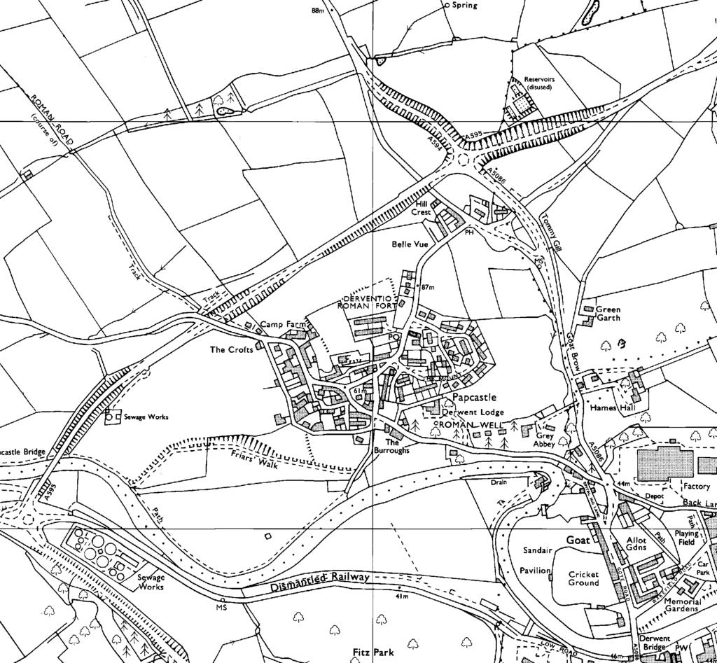
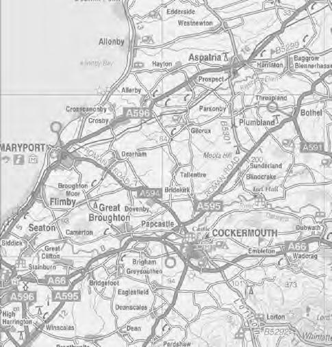
65
66
67
68
69
70
71


72 Derwent Lodge Cottage and Sibby Brows Field, Papcastle, Cumbria: Archaeological Report Plate 1: Trench A:excavation in progress, looking south-west. Plate 2: Trench A: Phase 3, hearth 9/22


73 Derwent Lodge Cottage and Sibby Brows Field, Papcastle, Cumbria: Archaeological Report Plate 3: Trench A, Phase 4, wall foundation 26 Plate 4: Trench A, Phase 5, showing wall footings 3, 4, and 5

74 Derwent Lodge Cottage and Sibby Brows Field, Papcastle, Cumbria: Archaeological Report Plate 5: Trench C, uppermost Roman features, looking east


75 Derwent Lodge Cottage and Sibby Brows Field, Papcastle, Cumbria: Archaeological Report Plate 6: Trench C, Phase 2, probable beam slot 142 Plate 7: Trench C, Phase 3, wall foundation 104


76 Derwent Lodge Cottage and Sibby Brows Field, Papcastle, Cumbria: Archaeological Report Plate 8: Trench C, Phase 3, wall 113 Plate 9: Trench D, uppermost Roman levels, looking east

77 Derwent Lodge Cottage and Sibby Brows Field, Papcastle, Cumbria: Archaeological Report Plate 10: Trench D, stone drain 135, with rubble spread 139 to the east and remains of metalled surface 128/129/132 to the west
An archaeological evaluation at 16 Seaview Road, Brightlingsea, Essex February 2004
 An archaeological evaluation at 16 Seaview Road, Brightlingsea, Essex February 2004 report prepared by Kate Orr on behalf of Highfield Homes NGR: TM 086 174 (c) CAT project ref.: 04/2b ECC HAMP group site
39, Walnut Tree Lane, Sudbury (SUY 073) Planning Application No. B/04/02019/FUL Archaeological Monitoring Report No. 2005/112 OASIS ID no.
 Planning Application No. B/04/02019/FUL Archaeological Monitoring Report No. 2005/112 OASIS ID no.") 39, Walnut Tree Lane, Sudbury (SUY 073) Planning Application No. B/04/02019/FUL Archaeological Monitoring Report No. 2005/112 OASIS ID no. 9273 Summary Sudbury, 39, Walnut Tree Lane, Sudbury (TL/869412;
39, Walnut Tree Lane, Sudbury (SUY 073) Planning Application No. B/04/02019/FUL Archaeological Monitoring Report No. 2005/112 OASIS ID no. 9273 Summary Sudbury, 39, Walnut Tree Lane, Sudbury (TL/869412;
ARCHAEOLOGICAL EVALUATION AT BRIGHTON POLYTECHNIC, NORTH FIELD SITE, VARLEY HALLS, COLDEAN LANE, BRIGHTON. by Ian Greig MA AIFA.
 ARCHAEOLOGICAL EVALUATION AT BRIGHTON POLYTECHNIC, NORTH FIELD SITE, VARLEY HALLS, COLDEAN LANE, BRIGHTON by Ian Greig MA AIFA May 1992 South Eastern Archaeological Services Field Archaeology Unit White
Monitoring Report No. 99
 Monitoring Report No. 99 Enniskillen Castle Co. Fermanagh AE/06/23 Cormac McSparron Site Specific Information Site Name: Townland: Enniskillen Castle Enniskillen SMR No: FER 211:039 Grid Ref: County: Excavation
An archaeological evaluation at the Lexden Wood Golf Club (Westhouse Farm), Lexden, Colchester, Essex
, Lexden, Colchester, Essex") An archaeological evaluation at the Lexden Wood Golf Club (Westhouse Farm), Lexden, Colchester, Essex January 2000 Archive report on behalf of Lexden Wood Golf Club Colchester Archaeological Trust 12 Lexden
An archaeological evaluation at the Lexden Wood Golf Club (Westhouse Farm), Lexden, Colchester, Essex January 2000 Archive report on behalf of Lexden Wood Golf Club Colchester Archaeological Trust 12 Lexden
Test-Pit 3: 31 Park Street (SK )
") -Pit 3: 31 Park Street (SK 40732 03178) -Pit 3 was excavated in a flower bed in the rear garden of 31 Park Street, on the northern side of the street and west of an alleyway leading to St Peter s Church,
-Pit 3: 31 Park Street (SK 40732 03178) -Pit 3 was excavated in a flower bed in the rear garden of 31 Park Street, on the northern side of the street and west of an alleyway leading to St Peter s Church,
2 Saxon Way, Old Windsor, Berkshire
 2 Saxon Way, Old Windsor, Berkshire An Archaeological Watching Brief For Mrs J. McGillicuddy by Pamela Jenkins Thames Valley Archaeological Services Ltd Site Code SWO 05/67 August 2005 Summary Site name:
An archaeological watching brief and recording at Brightlingsea Quarry, Moverons Lane, Brightlingsea, Essex October 2003
 An archaeological watching brief and recording at Brightlingsea Quarry, Moverons Lane, Brightlingsea, Essex commissioned by Mineral Services Ltd on behalf of Alresford Sand & Ballast Co Ltd report prepared
New Composting Centre, Ashgrove Farm, Ardley, Oxfordshire
 New Composting Centre, Ashgrove Farm, Ardley, Oxfordshire An Archaeological Watching Brief For Agrivert Limited by Andrew Weale Thames Valley Archaeological Services Ltd Site Code AFA 09/20 August 2009
Church of St Peter and St Paul, Great Missenden, Buckinghamshire
 Church of St Peter and St Paul, Great Missenden, Buckinghamshire An Archaeological Watching Brief for the Parish of Great Missenden by Andrew Taylor Thames Valley Archaeological Services Ltd Site Code
Greater London GREATER LONDON 3/606 (E ) TQ
 TQ") GREATER LONDON City of London 3/606 (E.01.6024) TQ 30358150 1 PLOUGH PLACE, CITY OF LONDON An Archaeological Watching Brief at 1 Plough Place, City of London, London EC4 Butler, J London : Pre-Construct
GREATER LONDON City of London 3/606 (E.01.6024) TQ 30358150 1 PLOUGH PLACE, CITY OF LONDON An Archaeological Watching Brief at 1 Plough Place, City of London, London EC4 Butler, J London : Pre-Construct
3. The new face of Bronze Age pottery Jacinta Kiely and Bruce Sutton
 3. The new face of Bronze Age pottery Jacinta Kiely and Bruce Sutton Illus. 1 Location map of Early Bronze Age site at Mitchelstown, Co. Cork (based on the Ordnance Survey Ireland map) A previously unknown
Colchester Archaeological Trust Ltd. A Fieldwalking Survey at Birch, Colchester for ARC Southern Ltd
 Colchester Archaeological Trust Ltd A Fieldwalking Survey at Birch, Colchester for ARC Southern Ltd November 1997 CONTENTS page Summary... 1 Background... 1 Methods... 1 Retrieval Policy... 2 Conditions...
7. Prehistoric features and an early medieval enclosure at Coonagh West, Co. Limerick Kate Taylor
 7. Prehistoric features and an early medieval enclosure at Coonagh West, Co. Limerick Kate Taylor Illus. 1 Location of the site in Coonagh West, Co. Limerick (based on the Ordnance Survey Ireland map)
Fieldwalking at Cottam 1994 (COT94F)
") Fieldwalking at Cottam 1994 (COT94F) Tony Austin & Elizabeth Jelley (19 Jan 29) 1. Introduction During the winter of 1994 students from the Department of Archaeology at the University of York undertook
Fieldwalking at Cottam 1994 (COT94F) Tony Austin & Elizabeth Jelley (19 Jan 29) 1. Introduction During the winter of 1994 students from the Department of Archaeology at the University of York undertook
Former Whitbread Training Centre Site, Abbey Street, Faversham, Kent Interim Archaeological Report Phase 1 November 2009
 Former Whitbread Training Centre Site, Abbey Street, Faversham, Kent Interim Archaeological Report Phase 1 November 2009 SWAT. Archaeology Swale and Thames Archaeological Survey Company School Farm Oast,
Fort Arbeia and the Roman Empire in Britain 2012 FIELD REPORT
 Fort Arbeia and the Roman Empire in Britain 2012 FIELD REPORT Background Information Lead PI: Paul Bidwell Report completed by: Paul Bidwell Period Covered by this report: 17 June to 25 August 2012 Date
An archaeological evaluation in the playground of Colchester Royal Grammar School, Lexden Road, Colchester, Essex
 An archaeological evaluation in the playground of Colchester Royal Grammar School, Lexden Road, Colchester, Essex February 2002 on behalf of Roff Marsh Partnership CAT project code: 02/2c Colchester Museum
Grim s Ditch, Starveall Farm, Wootton, Woodstock, Oxfordshire
 Grim s Ditch, Starveall Farm, Wootton, Woodstock, Oxfordshire An Archaeological Recording Action For Empire Homes by Steve Ford Thames Valley Archaeological Services Ltd Site Code SFW06/118 November 2006
Silwood Farm, Silwood Park, Cheapside Road, Ascot, Berkshire
 Silwood Farm, Silwood Park, Cheapside Road, Ascot, Berkshire An Archaeological Watching Brief For Imperial College London by Tim Dawson Thames Valley Archaeological Services Ltd Site Code SFA 09/10 April
An archaeological evaluation at the Blackwater Hotel, Church Road, West Mersea, Colchester, Essex March 2003
 An archaeological evaluation at the Blackwater Hotel, Church Road, West Mersea, Colchester, Essex report prepared by Laura Pooley on behalf of Dolphin Developments (U.K) Ltd NGR: TM 0082 1259 CAT project
Archaeological. Monitoring & Recording Report. Fulbourn Primary School, Cambridgeshire. Archaeological Monitoring & Recording Report.
 Fulbourn Primary School, Cambridgeshire Archaeological Monitoring & Recording Report October 2014 Client: Cambridgeshire County Council OA East Report No: 1689 OASIS No: oxfordar3-192890 NGR: TL 5190 5613
SALVAGE EXCAVATIONS AT OLD DOWN FARM, EAST MEON
 Proc. Hants. Field Club Archaeol. Soc. 36, 1980, 153-160. 153 SALVAGE EXCAVATIONS AT OLD DOWN FARM, EAST MEON By RICHARD WHINNEY AND GEORGE WALKER INTRODUCTION The site was discovered by chance in December
Monitoring Report No Sacred Heart Church Aghamore Boho Co. Fermanagh AE/10/116E. Brian Sloan L/2009/1262/F
 Monitoring Report No. 202 Sacred Heart Church Aghamore Boho Co. Fermanagh AE/10/116E Brian Sloan L/2009/1262/F Site Specific Information Site Address: Sacred Heart Church, Aghamore, Boho, Co. Fermanagh
1 The East Oxford Archaeology and History Project
 1 The East Oxford Archaeology and History Project EXOP TEST PIT 72 Location: Bartlemas Chapel, Cowley Date of excavation: 6-8 November 2013. Area of excavation: 0.8m x 1.2m, at the eastern end of the chapel.
ARCHAEOLOGICAL MONITORING REPORT
 ARCHAEOLOGICAL MONITORING REPORT SCCAS REPORT No. 2009/324 Thorington Hall, Stoke by Nayland SBN 087 HER Information Date of Fieldwork: November 2009 - January 2010 Grid Reference: TM 0131 3546 Funding
An archaeological watching brief on one section of an Anglian Water main Spring Lane, Lexden, Colchester
 An archaeological watching brief on one section of an Anglian Water main Spring Lane, Lexden, Colchester April-September 2001 on behalf of Breheny Contractors CAT project ref.: 01/4D Colchester Museum
Essex Historic Environment Record/ Essex Archaeology and History
 Essex Historic Environment Record/ Essex Archaeology and History CAT Report 578 Summary sheet Address: Kingswode Hoe School, Sussex Road, Colchester, Essex Parish: Colchester NGR: TL 9835 2528 Type of
CUMBRIA 2/635 (C ) NY
 NY") CUMBRIA Allerdale 2/635 (C.16.6017) NY 11803070 BRIDGE STREET, COCKERMOUTH Report on an Archaeological Evaluation at Bridge Street, Cockermouth, Cumbria (Report No. 5/00) Grahame, R Carlisle : Carlisle
CUMBRIA Allerdale 2/635 (C.16.6017) NY 11803070 BRIDGE STREET, COCKERMOUTH Report on an Archaeological Evaluation at Bridge Street, Cockermouth, Cumbria (Report No. 5/00) Grahame, R Carlisle : Carlisle
Greater London Region GREATER LONDON 3/567 (E.01.K099) TQ BERMONDSEY STREET AND GIFCO BUILDING AND CAR PARK
 TQ BERMONDSEY STREET AND GIFCO BUILDING AND CAR PARK") GREATER LONDON 3/567 (E.01.K099) TQ 33307955 156-170 BERMONDSEY STREET AND GIFCO BUILDING AND CAR PARK Assessment of an Archaeological Excavation at 156-170 Bermondsey Street and GIFCO Building and Car
GREATER LONDON 3/567 (E.01.K099) TQ 33307955 156-170 BERMONDSEY STREET AND GIFCO BUILDING AND CAR PARK Assessment of an Archaeological Excavation at 156-170 Bermondsey Street and GIFCO Building and Car
FURTHER MIDDLE SAXON EVIDENCE AT COOK STREET, SOUTHAMPTON (SOU 567)
") Roc. Hampshire Field Club Archaeol. Soc 52,1997, 77-87 (Hampshire Studies 1997) FURTHER MIDDLE SAXON EVIDENCE AT COOK STREET, SOUTHAMPTON (SOU 567) By M F GARNER andj VINCENT with a contribution byjacqueline
Roc. Hampshire Field Club Archaeol. Soc 52,1997, 77-87 (Hampshire Studies 1997) FURTHER MIDDLE SAXON EVIDENCE AT COOK STREET, SOUTHAMPTON (SOU 567) By M F GARNER andj VINCENT with a contribution byjacqueline
Bangor University. The Meillionydd Project: Characterising the double ringwork enclosures in Gwynedd Preliminary Excavation Report
 Bangor University The Meillionydd Project: Characterising the double ringwork enclosures in Gwynedd Preliminary Excavation Report Kate Waddington and Raimund Karl Bangor, August 2010 Contents Acknowledements
Cambridge Archaeology Field Group. Fieldwalking on the Childerley Estate, Cambridgeshire. Autumn 2014 to Spring Third interim report
 Cambridge Archaeology Field Group Fieldwalking on the Childerley Estate, Cambridgeshire Autumn 2014 to Spring 2015 Third interim report Summary Field walking on the Childerley estate of Martin Jenkins
UNIVERSITY OF LANCASTER ARCHAEOLOGY CONFERENCE. 9 March 2002
 UNIVERSITY OF LANCASTER CENTRE FOR NORTH-WEST REGIONAL STUDIES ARCHAEOLOGY CONFERENCE 9 March 2002 A Chairman's Reflections - David Shotter Over the past thirty years, this Conference has become an established
Cetamura Results
 Cetamura 2000 2006 Results A major project during the years 2000-2006 was the excavation to bedrock of two large and deep units located on an escarpment between Zone I and Zone II (fig. 1 and fig. 2);
An archaeological evaluation by trial-trenching at Playgolf, Bakers Lane, Westhouse Farm, Colchester, Essex
 An archaeological evaluation by trial-trenching at Playgolf, Bakers Lane, Westhouse Farm, Colchester, Essex commissioned by Mr Stephen Belchem on behalf of ADP Ltd. report prepared by Chris Lister Planning
Erection of wind turbine, Mains of Loanhead, Old Rayne, AB52 6SX
 Erection of wind turbine, Mains of Loanhead, Old Rayne, AB52 6SX Ltd 23 November 2011 Erection of wind turbine, Mains of Loanhead, Old Rayne, AB52 6SX CONTENTS 1 INTRODUCTION 3 2 ARCHAEOLOGICAL BACKGROUND
THE PRE-CONQUEST COFFINS FROM SWINEGATE AND 18 BACK SWINEGATE
 THE PRE-CONQUEST COFFINS FROM 12 18 SWINEGATE AND 18 BACK SWINEGATE An Insight Report By J.M. McComish York Archaeological Trust for Excavation and Research (2015) Contents 1. INTRODUCTION... 3 2. THE
Evidence for the use of bronze mining tools in the Bronze Age copper mines on the Great Orme, Llandudno
 Evidence for the use of bronze mining tools in the Bronze Age copper mines on the Great Orme, Llandudno Background The possible use of bronze mining tools has been widely debated since the discovery of
St Germains, Tranent, East Lothian: the excavation of Early Bronze Age remains and Iron Age enclosed and unenclosed settlements
 Proc Soc Antiq Scot, 128 (1998), 203-254 St Germains, Tranent, East Lothian: the excavation of Early Bronze Age remains and Iron Age enclosed and unenclosed settlements Derek Alexander* & Trevor Watkinsf
Moray Archaeology For All Project
 School children learning how to identify finds. (Above) A flint tool found at Clarkly Hill. Copyright: Leanne Demay Moray Archaeology For All Project ational Museums Scotland have been excavating in Moray
17 Phase 5. High and Late medieval features and activities AD
 17 Phase 5. High and Late medieval features and activities 1200 1550 AD 17.1 Results This time phase is based on all findings that can be placed in the High and Late medieval period 1200 1550 AD based
Archaeological sites and find spots in the parish of Burghclere - SMR no. OS Grid Ref. Site Name Classification Period
 Archaeological sites and find spots in the parish of Burghclere - SMR no. OS Grid Ref. Site Name Classification Period SU45NE 1A SU46880 59200 Ridgemoor Farm Inhumation Burial At Ridgemoor Farm, on the
Grange Farm, Widmer End, Hughenden, Buckinghamshire
 Grange Farm, Widmer End, Hughenden, Buckinghamshire An Archaeological Evaluation for British Flora by Andy Taylor Thames Valley Archaeological Services Ltd Site Code GFH 05/63 July 2005 Summary Site name:
ROMAN AND MEDIEVAL ACTIVITY IN THE UPPER WALBROOK VALLEY: EXCAVATIONS AT MOORGATE, CITY OF LONDON, EC2, 1997
 ROMAN AND MEDIEVAL ACTIVITY IN THE UPPER WALBROOK VALLEY: EXCAVATIONS AT 12 18 MOORGATE, CITY OF LONDON, EC2, 1997 Graham Bruce, Dominic Perring, Tim Stevens and Melissa Melikian SUMMARY In January and
ROMAN OBJECTS FROM LANCASHIRE AND CUMBRIA: A ROUND-UP OF FINDS REPORTED VIA THE PORT ABLE ANTIQUITIES SCHEME IN 2006
 ROMAN OBJECTS FROM LANCASHIRE AND CUMBRIA: A ROUND-UP OF FINDS REPORTED VIA THE PORT ABLE ANTIQUITIES SCHEME IN 2006 Dot Bruns INTRODUCTION The Portable Antiquities Scheme is a voluntary scheme to record
ARCHAEOLOGICAL S E R V I C E S. St Nicholas' Church, Barrack Hill, Nether Winchendon, Buckinghamshire. Archaeological Watching Brief.
 T H A M E S V A L L E Y ARCHAEOLOGICAL S E R V I C E S St Nicholas' Church, Barrack Hill, Nether Winchendon, Buckinghamshire Archaeological Watching Brief by Steven Crabb Site Code: STW17/229 (SP 7735
An archaeological watching brief at Sheepen, Colchester, Essex November-December 2003
 An archaeological watching brief at Sheepen, Colchester, Essex November-December 2003 report prepared by Ben Holloway on behalf of Colchester Borough Council CAT project ref.: 03/11c Colchester Museums
Archaeological evaluation at the Onley Arms, The Street, Stisted, Essex
 Archaeological evaluation at the Onley Arms, The Street, Stisted, Essex November 2014 report by Pip Parmenter and Adam Wightman with a contribution from Stephen Benfield and illustrations by Emma Holloway
Archaeological Watching Brief (Phase 2) at Court Lodge Farm, Aldington, near Ashford, Kent December 2011
 at Court Lodge Farm, Aldington, near Ashford, Kent December 2011") Archaeological Watching Brief (Phase 2) at Court Lodge Farm, Aldington, near Ashford, Kent December 2011 SWAT. Archaeology Swale and Thames Archaeological Survey Company School Farm Oast, Graveney Road
Archaeological Watching Brief (Phase 2) at Court Lodge Farm, Aldington, near Ashford, Kent December 2011 SWAT. Archaeology Swale and Thames Archaeological Survey Company School Farm Oast, Graveney Road
A Sense of Place Tor Enclosures
 A Sense of Place Tor Enclosures Tor enclosures were built around six thousand years ago (4000 BC) in the early part of the Neolithic period. They are large enclosures defined by stony banks sited on hilltops
Moated Site at Manor Farm, Islip, Oxfordshire
 Moated Site at Manor Farm, Islip, Oxfordshire An Archaeological Excavation By Jo Pine Site Code MFI05 December 2007 Summary Site name: Moated Site at Manor Farm, Islip, Oxfordshire Grid reference: SP 5298
Chapter 2. Remains. Fig.17 Map of Krang Kor site
 Chapter 2. Remains Section 1. Overview of the Survey Area The survey began in January 2010 by exploring the site of the burial rootings based on information of the rooted burials that was brought to the
Cambridge Archaeology Field Group. Fieldwalking on the Childerley Estate Cambridgeshire
 Cambridge Archaeology Field Group Fieldwalking on the Childerley Estate Cambridgeshire 2009 to 2014 Summary Fieldwalking on the Childerley estate of Martin Jenkins and Family has revealed, up to March
Phase 2 Urban consolidation AD
 Phase 2 Urban consolidation AD 1250-1350 The second recognised phase of activity at Rådhuspladsen corresponded approximately to the High medieval period (c. AD 1250 1350), and saw consolidation of the
NOTE A THIRD CENTURY ROMAN BURIAL FROM MANOR FARM, HURSTBOURNE PRIORS. by. David Allen with contributions by Sue Anderson and Brenda Dickinson
 Proc. Hampsh. Field Club Archaeol. Soc. 47, 1991, 253-257 NOTE A THIRD CENTURY ROMAN BURIAL FROM MANOR FARM, HURSTBOURNE PRIORS Abstract by. David Allen with contributions by Sue Anderson and Brenda Dickinson
TIPPERARY HISTORICAL JOURNAL 1994
 TPPERARY HSTORCAL JOURNAL 1994 County Tipperary Historical Society www.tipperarylibraries.ie/ths society@tipperarylibraries. ie SSN 0791-0655 Excavations at Cormac's Chapel, Cashel, 1992 and 1993: a preliminary
TA 04/15 OASIS ID
 River Tees Rediscovered Project Archaeological Excavations in Egglescliffe Stockton on Tees 2015 TA 04/15 OASIS ID 1-238455 River Tees Rediscovered Project Archaeological Excavations in Egglescliffe Stockton
Lanton Lithic Assessment
 Lanton Lithic Assessment Dr Clive Waddington ARS Ltd The section headings in the following assessment report refer to those in the Management of Archaeological Projects (HBMC 1991), Appendix 4. 1. FACTUAL
Archaeological trial-trenching evaluation at Chappel Farm, Little Totham, Essex. April 2013
 Archaeological trial-trenching evaluation at Chappel Farm, Little Totham, Essex April 2013 report prepared by Ben Holloway commissioned by Tim Harbord Associates on behalf of Mr Tom Howie Planning reference:
Excavations at Shikarpur, Gujarat
 Excavations at Shikarpur, Gujarat 2008-2009 The Department of Archaeology and Ancient History, the M. S. University of Baroda continued excavations at Shikarpur in the second field season in 2008-09. In
A visit to the Wor Barrow 21 st November 2015
 A visit to the Wor Barrow 21 st November 2015 Following our exploration of Winkelbury a few weeks previously, we fast forwarded 12 years in Pitt Rivers remarkable series of excavations and followed him
Control ID: Years of experience: Tools used to excavate the grave: Did the participant sieve the fill: Weather conditions: Time taken: Observations:
 Control ID: Control 001 Years of experience: No archaeological experience Tools used to excavate the grave: Trowel, hand shovel and shovel Did the participant sieve the fill: Yes Weather conditions: Flurries
THE EXCAVATION OF A BURNT MOUND AT HARBRIDGE, HAMPSHIRE
 Proc Hampshire Field ClubArchaeolSoc5i, 1999,172-179 (Hampshire Studies 1999) THE EXCAVATION OF A BURNT MOUND AT HARBRIDGE, HAMPSHIRE by S J SHENNAN ABSTRACT A burnt mound of Late Brome Age date, as indicated
Undley Hall, Lakenheath LKH 307
 ARCHAEOLOGICAL EVALUATION AND MONITORING REPORT SCCAS REPORT No. 2010/005 Undley Hall, Lakenheath LKH 307 E. Muldowney SCCAS January 2010 www.suffolkcc.gov.uk/e-and-t/archaeology Lucy Robinson, County
Excavation. Post-Medieval Ditches. Land off Norwich Common Road Wymondham Norfolk. Excavation. Client: November 2013
 Land off Norwich Common Road Wymondham Norfolk. Excavation November 2013 Client: OA East Report No: 1546 OASIS No: oxfordar3-163105 NGR: TG 12770 02684 Excavation Post-Medieval Ditches Post-Medieval Ditches
AN EARLY MEDIEVAL RUBBISH-PIT AT CATHERINGTON, HAMPSHIRE Bj>J. S. PILE and K. J. BARTON
 AN EARLY MEDIEVAL RUBBISH-PIT AT CATHERINGTON, HAMPSHIRE Bj>J. S. PILE and K. J. BARTON INTRODUCTION THE SITE (fig. 21) is situated in the village of Catherington, one mile north-west of Horndean and 200
ARCHAEOLOGICAL EXCAVATION REPORT: THE PADDOCK, HIGH DIKE, NAVENBY, LINCOLNSHIRE
 ARCHAEOLOGICAL EXCAVATION REPORT: THE PADDOCK, HIGH DIKE, NAVENBY, LINCOLNSHIRE NGR: 499398, 357274 AAL Site Code: NAPA 13 OASIS Reference Number: allenarc1-205997 Report prepared for Navenby Archaeology
Caistor Roman Project Interim Summary of 2015 Season of Test pits at Caistor Old Hall
 Caistor Roman Project Interim Summary of 2015 Season of Test pits at Caistor Old Hall Introduction This brief report summarises the first results of the 2015 campaign of test-pitting in the grounds of
FEATURE DESCRIPTIONS: PART 1. SAN AGUSTÍN MISSION LOCUS, THE CLEARWATER SITE, AZ BB:13:6 (ASM)
") CHAPTER 4 FEATURE DESCRIPTIONS: PART 1. SAN AGUSTÍN MISSION LOCUS, THE CLEARWATER SITE, AZ BB:13:6 (ASM) Thomas Klimas, Caramia Williams, and J. Homer Thiel Desert Archaeology, Inc. Archaeological work
CHAPTER 4 FEATURE DESCRIPTIONS: PART 1. SAN AGUSTÍN MISSION LOCUS, THE CLEARWATER SITE, AZ BB:13:6 (ASM) Thomas Klimas, Caramia Williams, and J. Homer Thiel Desert Archaeology, Inc. Archaeological work
AREA C. HENRY 0. THOMPSON American Center of Oriental Research Amman, Jordan
 AREA C HENRY 0. THOMPSON American Center of Oriental Research Amman, Jordan Of the 1971 work previously reported,' Squares 4,5, and 6 were not excavated in 1973, but work in Squares 1, 2, and 3 was continued.
Chapel House Wood Landscape Project. Interim Report 2013
 Chapel House Wood Landscape Project Interim Report 2013 Chapel House Wood Landscape Project Interim Report 2013 The annual Dales Heritage Field School was held at Chapel House Wood again this year, and
THE RAVENSTONE BEAKER
 DISCOVERY THE RAVENSTONE BEAKER K. J. FIELD The discovery of the Ravenstone Beaker (Plate Xa Fig. 1) was made by members of the Wolverton and District Archaeological Society engaged on a routine field
Suburban life in Roman Durnovaria
 Suburban life in Roman Durnovaria Additional specialist report Finds Ceramic building material By Kayt Brown Ceramic building material (CBM) Kayt Brown A total of 16420 fragments (926743g) of Roman ceramic
ST PATRICK S CHAPEL, ST DAVIDS PEMBROKESHIRE 2015
 ST PATRICK S CHAPEL, ST DAVIDS PEMBROKESHIRE 2015 REPORT FOR THE NINEVEH CHARITABLE TRUST THE UNIVERSITY OF SHEFFIELD AND DYFED ARCHAEOLOGICAL TRUST Introduction ST PATRICK S CHAPEL, ST DAVIDS, PEMBROKESHIRE,
WESTSIDE CHURCH (TUQUOY)
") Property in Care (PIC) ID: PIC324 Designations: Scheduled Monument (SM90312) Taken into State care: 1933 (Guardianship) Last reviewed: 2004 HISTORIC ENVIRONMENT SCOTLAND STATEMENT OF SIGNIFICANCE WESTSIDE
Property in Care (PIC) ID: PIC324 Designations: Scheduled Monument (SM90312) Taken into State care: 1933 (Guardianship) Last reviewed: 2004 HISTORIC ENVIRONMENT SCOTLAND STATEMENT OF SIGNIFICANCE WESTSIDE
Chapter 2: Archaeological Description
 Chapter 2: Archaeological Description Phase 1 Late Neolithic, c 3000-2400 BC (Figs 6-9) Evidence of Neolithic activity was confined to pits dug across the southern half of the site (Fig. 6). Eighteen pits
This is a repository copy of Anglo-Saxon settlements and archaeological visibility in the Yorkshire Wolds.
 This is a repository copy of Anglo-Saxon settlements and archaeological visibility in the Yorkshire Wolds. White Rose Research Online URL for this paper: http://eprints.whiterose.ac.uk/1172/ Book Section:
Novington, Plumpton East Sussex
 Novington, Plumpton East Sussex The Flint Over 1000 pieces of flintwork were recovered during the survey, and are summarised in Table 0. The flint is of the same types as found in the previous survey of
Forteviot, Perthshire 2008: Excavations of a henge monument and timber circle. Data Structure and Interim Report. by Gordon Noble and Kenneth Brophy
 Forteviot, Perthshire 2008: Excavations of a henge monument and timber circle Data Structure and Interim Report by Gordon Noble and Kenneth Brophy Summary This interim report will describe the provisional
MARSTON MICHAEL FARLEY
 MARSTON MICHAEL FARLEY On 9 March agricultural contractors, laying field drains for Bucks County Council Land Agent's Department, cut through a limestone structure at SP 75852301 in an area otherwise consistently
Archaeological Material From Spa Ghyll Farm, Aldfield
 Archaeological Material From Spa Ghyll Farm, Aldfield Introduction Following discussions with Linda Smith the Rural Archaeologist for North Yorkshire County Council, Robert Morgan of 3D Archaeological
Wantage County Primary School, Garston Lane, Wantage, Oxfordshire
 Wantage County Primary School, Garston Lane, Wantage, Oxfordshire An Archaeological Evaluation for Oxfordshire County Council by Erlend Hindmarch Thames Valley Archaeological Services Ltd Site Code GLW
Bronze-Age and Romano-British Sites South-East of Tewkesbury: evaluations and excavations
 From the Transactions of the Bristol and Gloucestershire Archaeological Society Bronze-Age and Romano-British Sites South-East of Tewkesbury: evaluations and excavations 1991-7 by G. Walker, A. Thomas
Centre for Archaeological Fieldwork,
 Centre for Archaeological Fieldwork, School of Geography, Archaeology and Palaeoecology, Queen s University Belfast Data Structure Report No. 70 (preliminary report) Archaeological Excavations at Carrickfergus
A NEW ROMAN SITE IN CHESHAM
 A NEW ROMAN SITE IN CHESHAM KEITH BRANIGAN AND MICHAEL KIRTON THE site under discussion was first noted in 1958 and since that time several discoveries have been made. Its investigation has been pursued
SUMMARY REPORT OF 2009 INVESTIGATIONS AT OLD TOWN, LANCASTER COUNTY, SOUTH CAROLINA
 SUMMARY REPORT OF 2009 INVESTIGATIONS AT OLD TOWN, LANCASTER COUNTY, SOUTH CAROLINA by R. P. Stephen Davis, Jr. Brett H. Riggs, and David J. Cranford 2012 Between April 29 and June 12, 2009, archaeological
16 members of the Fieldwalking Group met York Community Archaeologist Jon Kenny at Lou Howard s farm, Rose Cottage Farm, at
 Terrington History Group Fieldwalking Group Field 1 Final report 21 October 2011 - fieldwalking 16 members of the Fieldwalking Group met York Community Archaeologist Jon Kenny at Lou Howard s farm, Rose
Tell Shiyukh Tahtani (North Syria)
") Tell Shiyukh Tahtani (North Syria) Report of the 2010 excavation season conducted by the University of Palermo Euphrates Expedition by Gioacchino Falsone and Paola Sconzo In the summer 2010 the University
Tell Shiyukh Tahtani (North Syria) Report of the 2010 excavation season conducted by the University of Palermo Euphrates Expedition by Gioacchino Falsone and Paola Sconzo In the summer 2010 the University
Forteviot, Perthshire: Excavations at the Entrance Avenue of the Neolithic Palisaded Enclosure Interim Report and Data Structure Report
 Forteviot, Perthshire: Excavations at the Entrance Avenue of the Neolithic Palisaded Enclosure 2007 Interim Report and Data Structure Report by Gordon Noble and Kenneth Brophy Table of Contents Summary
Limited Archaeological Testing at the Sands House Annapolis, Maryland
 Limited Archaeological Testing at the Sands House Annapolis, Maryland Report Submitted to Four Rivers Heritage Area by John E. Kille, Ph.D., Shawn Sharpe, and Al Luckenbach, Ph.D February 10, 2012 In May-June
LAND WEST OF ELM GROVE, EBRINGTON, GLOUCESTERSHIRE. NGR: SP (centred) ARCHAEOLOGICAL EVALUATION
 ARCHAEOLOGICAL EVALUATION") LAND WEST OF ELM GROVE, EBRINGTON, GLOUCESTERSHIRE. NGR: SP 1892 4012 (centred) ARCHAEOLOGICAL EVALUATION Report No. 640 May 2009 1q LAND WEST OF ELM GROVE, EBRINGTON, GLOUCESTERSHIRE. NGR: SP 1892 4012
LAND WEST OF ELM GROVE, EBRINGTON, GLOUCESTERSHIRE. NGR: SP 1892 4012 (centred) ARCHAEOLOGICAL EVALUATION Report No. 640 May 2009 1q LAND WEST OF ELM GROVE, EBRINGTON, GLOUCESTERSHIRE. NGR: SP 1892 4012
YCCCART is very grateful to Richard Broomhead for permission to publish this report online.
 YCCCART 2017/Y2 Yatton & Congresbury Wildlife Action Group A Documentary & Archaeological Survey Of Two Moorland Sites In Yatton & Congresbury R.A.Broomhead BA Field Archaeologist RAB/15/9 YCCCART is very
STONES OF STENNESS HISTORIC ENVIRONMENT SCOTLAND STATEMENT OF SIGNIFICANCE
 Property in Care (PIC) ID: PIC321 Designations: Scheduled Monument (SM90285); Taken into State care: 1906 (Guardianship) Last reviewed: 2003 HISTORIC ENVIRONMENT SCOTLAND STATEMENT OF SIGNIFICANCE STONES
A Fieldwalking Project At Sompting. West Sussex
 by John Funnell Introduction A Fieldwalking Project At Sompting. West Sussex During March -and April 1995 the Brighton and Hove Archaeological Society conducted fie1dwa1king in a field at Sompting West
An archaeological watching brief at St Leonard s church, Hythe Hill, Colchester, Essex
 An archaeological watching brief at St Leonard s church, Hythe Hill, Colchester, Essex report prepared by Adam Wightman on behalf of Dorvell Construction CAT project ref.: 10/5d Colchester and Ipswich
NORTH PENNINES ARCHAEOLOGY LTD
 NORTH PENNINES ARCHAEOLOGY LTD Client Report No. CP/446/07 Planning Reference: 2060799 NCCCT Reference: T13/23; 5982 OASIS Reference: northpen3-25609 Tony Liddell B.Sc. Nenthead Mines Heritage Centre Nenthead
Small Finds Assessment, Minchery Paddock, Littlemore, Oxford (MP12)
") Small s Assessment, Minchery Paddock, Littlemore, Oxford (MP12) Introduction A total of 51 objects recovered from excavations at Minchery Paddock, Littlemore, Oxford (MP12) were submitted for dating and
Small s Assessment, Minchery Paddock, Littlemore, Oxford (MP12) Introduction A total of 51 objects recovered from excavations at Minchery Paddock, Littlemore, Oxford (MP12) were submitted for dating and
E x cav atio n R e p o r t
 Medieval Trackway on land at Ivy Farm Royston, Hertfordshire Excavation Report E x cav atio n R e p o r t October 2011 Client: CgMs Consulting OA East Report No: 1305 OASIS No: oxfordar3-112012 NGR: TL
THE UNFOLDING ARCHAEOLOGY OF CHELTENHAM
 THE UNFOLDING ARCHAEOLOGY OF CHELTENHAM The archaeology collection of Cheltenham Art Gallery & Museum contains a rich quantity of material relating to the prehistoric and Roman occupation of the North