Data Structure Report: Boho High Cross, Toneel North, Co. Fermanagh
|
|
|
- Barbara Alexander
- 5 years ago
- Views:
Transcription
1
2 Data Structure Report: Boho High Cross, Toneel North, Co. Fermanagh Colm Donnelly, Philip Macdonald, Eileen Murphy and Nicholas Beer SMR No: Ferm 210:14 Grid Reference: H Excavation Licence: AE/02/49 Scheduled Ancient Monument Consent: Ferm 210:14/B105/86
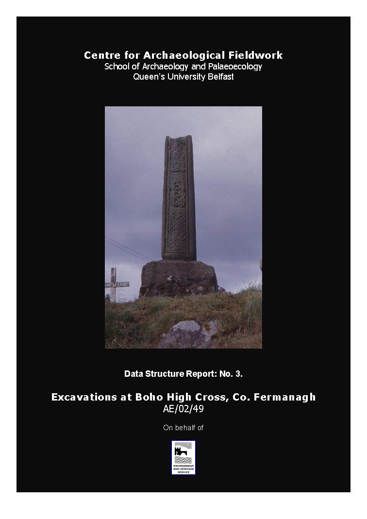
3 1 Summary 1.1 A small-scale excavation was undertaken at Boho High Cross, Toneel North, County Fermanagh, during the period from 29 th May to 4 th June The High Cross is perhaps 1,000 years old and prior to the excavation - comprised a shaft and socketed base of red sandstone. A scheduled monument, it is positioned on an eminence within the Roman Catholic graveyard at Boho (Figure 1) in the parish of Botha. 1.2 The shaft of the High Cross had developed a pronounced eastward lean and there were concerns among the local inhabitants that it might topple over. The Parish Priest, Fr. Lorcan Lynch, therefore contacted Claire Foley (EHS Senior Inspector) who agreed for the EHS to undertake engineering work to rectify the monument s tilt and thereby secure its future. The engineering work, however, would require jacks to be placed underneath the socketed base, which was partially buried beneath the modern ground surface. This would mean that the area to the east of the cross would require excavation to provide the EHS conservation crew with a service trench of a suitable depth to enable access beneath the monument. 1.3 The archaeological excavation was directed by Dr Colm Donnelly and Dr Eileen Murphy, School of Archaeology and Palaeoecology, Queen s University Belfast, on behalf of the Environment and Heritage Service: Built Heritage. Further archaeological monitoring was undertaken between 19 th and 20 th June 2002 by Dr Philip Macdonald of the Centre for Archaeological Fieldwork at Queen s, when the EHS conservation team, led by Mr Billy Silcock, undertook the engineering work to correct the cross s tilt. The results of the monitoring are incorporated into the account of the excavation presented in this Data Structure Report. 1.4 As the High Cross is located within a cemetery, great care was taken to ensure that only a minimum amount of disturbance was made to the graves and other deposits directly surrounding the monument. Consequently, the scale of the excavations was limited. A one metre square trench was opened to the east of the cross (Trench One) in order to provide a service trench so that the monument could be propped with jacks while new supports were put in place beneath it. In addition, an L-shaped trench (Trench Two) was opened on the northern and western side of the monument to remove the soil burden from behind the socketed base. 1.5 A research agenda, however, was incorporated into the project design and two objectives were identified. First, could the excavation help to establish the date when the High Cross was erected at its present location in the graveyard? Second, would the excavation help to ascertain the character and extent of the socketed base? Although of limited scale and 1
4 duration the excavation programme at Boho High Cross has provided a wealth of new information concerning this monument and provided new insight into its history. 1.6 The dimensions of the socketed base previously provided by academics (eg: Harbison 1992, 28) was based on what was visible above ground level. The excavation enabled the full dimensions of the base to be determined. In addition, it was hitherto unknown that the socketed base was placed on a large red sandstone foundation slab, the general dimensions of which have also now been recorded. 1.7 The excavation has shown that the High Cross does not appear to be located in its original position since it is set over a charnel pit containing post-medieval artefacts. It is considered probable that the cross was re-erected at its current location during the major work undertaken in the graveyard during the first decades of the 1800s when the old ecclesiastical site was re-used for Roman Catholic worship and a new church constructed. It may even have been the case that this work led to the re-discovery of the cross. 2
5 3
6 2 Introduction 2.1 General This report details the results of an archaeological investigation undertaken at Boho High Cross, Toneel North, County Fermanagh, during the periods from 29 th May to 4 th June 2002 and 19 th and 20 th June The work was conducted by the Centre for Archaeological Fieldwork, School of Archaeology and Palaeoecology, Queen s University Belfast, on behalf of the Environment and Heritage Service: Built Heritage. 2.2 Background The High Cross is located within Boho Graveyard, on an eminence overlooking the Roman Catholic Church of the Sacred Heart to the west. The monument is missing its ringed head and comprises a weathered red sandstone shaft with accompanying socketed base. The shaft is decorated with rectangular panels of interlace, spirals and biblical scenes and has attracted academic attention since the late 19 th century. In more recent times the images have been described in detail by Hamlin (1976, ) and Harbison (1992, 28-29). Hamlin noted that there are stylistic similarities between panel depicting Adam and Eve on the east face of the Boho High Cross and a similar depiction on the High Cross at Drumcliff in County Sligo (O Gallachair 1984, 42). In addition, there is a blank area with a neatly worked hole on each of the north and south faces of the shaft. It has been suggested that the holes housed a tie-piece holding in place a vertical strut which would have supported the arm of the cross on each side (Harbison 1992, 28) and this is another shared feature with the Drumcliff High Cross. The loose arm fragment of a cross at one time lay on the ground near the monument, but in the late 1970s it was moved inside the church for safekeeping (O Gallachair 1984, 42). It is possible that the arm fragment may have originally belonged to the High Cross (Harbison 1992, 29) The ecclesiastic site in Toneel North has been in use since the Early Christian period when it is thought to have been the site of a monastery or nunnery (O Gallachair 1984, 38-41) whose patron saint was Feadhbar or Faber. The site housed a parish church in the medieval period and the Annals of Ulster refer to an erenagh in It would seem, however, that the site had fallen into disuse as a place of worship by the 17 th century and that it had become abandoned. In 1777 the first Church of Ireland church in Boho was constructed in the townland of Farnaconnell (Rowan 1979, 148) and, significantly, the pointed-arched doorway in the west gable of this church is of medieval date (Hickey 1985, 84). The most probable source for this medieval carved stonework was the old abandoned church at Boho. Soon after 1777 the local Roman Catholic population, probably under the guidance of Fr. Patrick Thally, constructed a Mass-house also in the townland of 4
7 Farnaconnell (O Gallachair 1984, 43). It is to be noted that the location of this Mass-house is marked on the first edition of the Ordnance Survey six-inch map sheet for the area in The Mass-house, however, had become used as a school by 1824 (ibid.) and may have been abandoned by This was because Roman Catholic worship had moved back to the old ecclesiastical site at Boho where Fr. Nicholas Smyth had constructed a new church, completed by It is also of interest to note that the 1834 six-inch map sheet records the existence of a lime-kiln within the graveyard, no doubt used during the construction of the church. The church was subsequently refurbished in (ibid., 45) and continues in use to the present The earliest reference to the High Cross belongs to 1834, when Captain Alexander Henderson reported in the Ordnance Survey Memoirs for the parish that: In the townland of Toneel near the site of an old monastic building there is a stone about 5 feet high and about 1 foot and a half by 6 inches, rudely carved on each side, but the figures, though in tolerable good relief, are not sufficiently characterised to warrant anything more than conjecture as to whom they were intended to represent (Day and McWilliams 1992, 10). Elsewhere in the memoir Captain Henderson noted that the Roman Catholic chapel in the parish had been built upon the site of an old abbey or monastery in the same townland (ibid., 8) evidently the church constructed by Fr. Smyth and completed in Reason for Excavation and Research Objectives The shaft of the High Cross had developed a pronounced eastward lean and there were concerns among local people that it might fall over. The Parish Priest, Fr. Lorcan Lynch, contacted Claire Foley (EHS Senior Inspector) who agreed that the EHS would undertake engineering work to rectify the monument s tilt and thereby secure its future. The engineering work, however, would require jacks to be placed underneath the socketed base, which was partially buried beneath the modern ground surface. This would mean that the area to the east of the cross would require archaeological excavation to provide the EHS conservation crew with a service trench of a suitable depth to enable access beneath the monument The proposed excavation, however, also offered a first opportunity for the archaeological investigation of the High Cross and two research objectives were identified. First, the excavation might help to elucidate the date of the erection of the cross at its current location within the graveyard and, second, it might help ascertain the character and extent of its socketed base, the lower section of which was buried beneath the modern ground surface. 5
8 2.4 Previous work at the site While the High Cross has been previously studied for its artistic and stylistic detail (see above), there had not been any previous archaeological investigation at the site. The only known intrusive work undertaken in the vicinity of the cross other than burials was undertaken by a parishioner, Barney McHugh, in This work was an attempt to prevent the collapse of the cross and involved the opening of an area to the immediate east of the socketed base. A number of large stones were then placed at the front of the base and the opening then backfilled (Frank Lynch, pers comm, 2002). 2.5 Archiving A copy of this report has been deposited with the Environment and Heritage Service, DOE NI. All site records and finds are temporarily archived with the Centre for Archaeological Fieldwork within the School of Archaeology and Palaeoecology, Queen s University Belfast. 2.6 Credits and Acknowledgements The excavations were directed by Dr Colm Donnelly and Dr Eileen Murphy. The subsequent monitoring was undertaken by Dr Philip Macdonald Assistance during the course of the excavation and in the preparation of this report was kindly provided by: John Davison (QUB); Claire Foley, Marion Meek and Billy Silcock (EHS); Fr Lorcan Lynch, Mr Maguire, John Curran, Frank Lynch, and Brian Black The illustrations in this report were prepared by Bronagh Murray of the Centre for Archaeological Fieldwork. 6
9 3 Excavation 3.1 Methodology As the high cross is a scheduled monument within an active graveyard, the excavation methodology was informed by the need to ensure that only a minimum amount of disturbance was made to the graves and other deposits surrounding the monument Excavation was undertaken from the 29 th May to the 4 th June A one metre square trench was opened immediately to the east of the cross (Trench One) in order to provide the EHS conservation team with access to the cross s foundation slab so that it could be levelled and secured. To provide additional access to the monument for the engineering team, a small L-shaped trench (Trench Two) was also opened on the northern and eastern sides of the monument (Figure 2). As the two trenches were joined, the same context numbers were used where appropriate - for both stratigraphic sequences Archaeological monitoring was undertaken from the 19 th to the 20 th June 2002 while the EHS conservation team undertook the engineering work required to correct the cross s tilt. The results of the monitoring are incorporated into the following account of the excavations Both the excavation and the subsequent monitoring of the site were undertaken in accordance with the specification document supplied by EHS (see Appendix Seven). Scheduled Monument Consent was obtained from EHS prior to the commencement of the excavation The excavations were undertaken by hand and the context record for the site was created using the standard context recording method. Individual features and deposits were photographed both prior to and following their excavation and included in a series of overall plans (Scale 1:10) and sections (Scale 1:10) that were prepared throughout the course of the excavation. For details of site photography see Appendix Three and for field illustrations see Appendix Four. In addition to the photography and illustration, the principal site records consisted of context sheets augmented by separate registers of small finds (Appendix Five) and samples (Appendix Six). Following the completion of the site recording, the tilt of the high cross was corrected and both excavation trenches were manually backfilled by the EHS conservation team Prior to the commencement of the excavation the High Cross s shaft and socketed base were secured in place by scaffolding erected by the EHS conservation team. A rigorous assessment of the health and safety aspects of the work was also undertaken. 7
10 8
11 3.1.7 The excavation was certain to disturb human bones interred within the cemetery. While Fr Lynch had sought and gained approval for this programme of work from his congregation, every effort was made to advance the excavation in a sensitive manner. All human bones recovered from the trench were immediately collected and bagged on discovery, while sheeting was placed over the two trenches each evening and at weekends. The human bones retrieved during the excavation were taken to the Bone Laboratory in the Palaeoecology Centre at Queen s University Belfast for washing, storage and analysis. Once this analysis has been completed the bones will be returned to Boho graveyard for reburial. 3.2 Account of the excavations The excavations consisted of two trenches, one to the east of the High Cross (Trench One) and the other to its west and north sides (Trench Two). It is recommended that the Harris Matrices for the site (see Appendix Two) and Figures 3 and 4 are referred to while reading the following account of the stratigraphic sequences revealed in both trenches. 3.3 Trench One Trench One was one metre square in size, and aligned north-south and east-west. Underneath the turf line (Context No.1) was a mixed, dark brown, humic layer (Context No.2) which varied in depth from 0.15 to 0.35 metres and extended throughout the trench. Artefacts recovered from this layer potentially ranged in date throughout the post-medieval period and up to the present day. They included a single sherd of post-medieval pottery (Small Find No.7), a clay pipe stem (Small Find No.14), 21 iron coffin nails (Small Find Nos.19-24, 37-51), two fragments of glass (Small Find Nos. 9 and 13) and a modern glass Rosary bead (Small Find No.12). The humic layer also contained a relatively small number of disarticulated human bones. Following its excavation the stratigraphic sequence for Trench One split into two separate elements: the socketed base and underlying foundation slab of the high cross (Context Nos. 3 and 4) and a relatively modern capping deposit and associated gully (Context Nos.5, 11 and 6) Underlying the humic layer, and located c metres to the east of the High Cross, was a thick deposit of dark grey sandy clay loam (Context Nos.5 and 11) which extended as far as the eastern edge of the trench. The deposit varied in thickness from 0.10 to 0.23 metres and appeared to be deliberately deposited as it respected the eastern edge of the foundation slab of the High Cross (Context No.4). Artefacts recovered from it included a modern glass Rosary bead (Small Find No.11) identical to the one found in the overlying humic layer (Context No.2), as well as several undiagnostic fragments of ironwork (Small 9
12 Find Nos.52-58) and 40 iron coffin nails (Small Find Nos.59-98). A relatively small amount of disarticulated human skeletal remains were also recovered from the deposit. The deposit is interpreted as a relatively recent deliberate capping of the underlying deposits within the graveyard Cut through the top of the capping deposit (Context Nos.5 and 11) was a straight, narrow gully (Context No.6) which ran for a length of c.0.70 metres from the western edge of the clay cap towards the eastern end of the trench. The gully narrowed along its length from a width of 0.20 metres at its western end to a width 0.07 metres, and it varied in depth from 0.15 to 0.20 metres. The function of the gully is not certain but given its relatively recent date, demonstrated by the recovery of a modern glass Rosary bead from the deposit it is cut into, it may be related to a previous attempt to halt the tilting of the High Cross by improving the drainage around the monument. The presence of a number of medium sized stones bedded into Context Nos. 5 and 11 (see stones marked a to e in Figure 2) may also relate to this programme of work In addition to exposing the capping deposit and associated gully (Context Nos.5, 11 and 6), the excavation of the humic layer (Context No.2) also uncovered the sandstone foundation slab (Context No.4) upon which the High Cross s socketed base (Context No.3) stands The rectangular-sectioned sandstone socketed base, which is decorated with a double roll moulding at the edges, had not been fully exposed prior to the 2002 excavations and so previous descriptions of the monument have not included a record its true dimensions. Excavations demonstrated that it is 0.80 metres high while, at its base, it measures 0.97 metres (north-south) by 0.77 metres (east-west). The socketed base was noticeably more weathered below the turf line giving its generally flared profile a slightly waisted character from the monument s eastern and western sides. In addition to the small circular depression previously recorded by Harbison (1992, fig.79) adjacent to the upper western corner on the socketed base s southern face, a second circular depression (diameter 0.03 metres) was uncovered on the northern side of the base in a relatively low, central position, c.0.15 metres above the foundation slab (Context No.4). Although on opposite faces of the socketed base, these two small circular depressions do not correspond and their original function is not obvious. The bottom of the socketed base was cracked and weathered on its eastern and western sides Excavation revealed that the socketed base (Context No.3) was set on a large red sandstone foundation slab that varied in thickness from metres but had a flat upper face (Context No.4). The slab was not fully exposed during the excavations but measures at least 1.28 metres (north-south) by 1.13 metres (east-west). The upper surface of the foundation slab is recessed to accommodate the socketed base (Context 10
13 No.3). This recessing survives best on the western edge of the slab where a neatly formed raised edge meets flush with the edge of the socketed base (Plate Five) Stratigraphically underlying both the capping deposit (Context Nos. 5 and 11) and the foundation slab (Context No.4), was a dark grey brown silty clay loam (Context Nos. 7 and 10) which included a charnel pit deposit (Context No.8) physically located underneath the foundation slab. These deposits were only partially excavated to a depth of 0.45 metres. The silty clay loam contained a relatively small amount of disarticulated human bones and four iron coffin nails (Small Find Nos , 133) and probably represents a mixed graveyard soil The charnel pit deposit (Context No.8) located within the graveyard soil (Context Nos. 7 and 10) contained three iron coffin fittings (Small Find Nos.102, ), 28 iron coffin nails, some with surviving fragments of partially mineralised wood, (Small Find Nos ) and a large amount of disarticulated human bone as well as the skulls and long bones of at least three individuals (the location of two of which are marked as S1 and S2 in Figure 3), some of which were partially articulated. The survival of fragments of partially mineralised coffin wood suggests that both the charnel pit (Context No.8) and the dark grey brown silty clay loam (Context Nos. 7 and 10) are not deposits of any great antiquity. As the surviving elements of the High Cross are stratigraphically later this suggests that the monument was only erected on its current site at some point in the relatively recent past. 3.4 Trench Two Trench Two was a small L-shaped trench, c.0.2 metres wide, cut around the western and northern sides of the monument. The only deposits uncovered were the turf line (Context No.1) and the mixed, dark brown, humic layer (Context No.2) which was only partially excavated to a depth of 0.55 metres. The humic layer (Context No.2) contained disarticulated human bone and a variety of artefacts including worked slate (Small Find Nos.1-2), two clay pipe stems (Small Find Nos.3, 10), two fragments of glass (Small Find Nos.5, 8), a piece of plastic (Small Find No.4), a pocket knife (Small Find No.25), an iron coffin mount (Small Find No.16) and 13 iron coffin nails (Small Find Nos.17-18, 26-36). As with Trench One, the excavation of these deposits uncovered the socketed base (Context No.3) and foundation slab (Context No.4) of the High Cross. A longitudinal void (denoted as V in Figure 2) was present along the line of the foundation slab. This void was created by the forward movement of the foundation slab away from the dark brown humic layer when the monument began to lean eastward. 11
14 12
15 13
16 4 Discussion 4.1 Introduction The High Cross at Boho joins a small corpus of other examples of this monument type that have been excavated in Ireland in recent years and is the first example to be excavated in Northern Ireland. In the early 1990s Con Manning and Heather King investigated the sites of three crosses at Clonmacnoise, County Offaly, following the removal and relocation of the monuments into the monastery s Visitor Centre to protect them from deteriorating environmental conditions (King 1992). In 1999 Heather King also excavated at the North Cross in St John s Church of Ireland churchyard at Ballymore Eustace in County Kildare (King 2000), while in 1998 Miriam Clyne investigated the site of a High Cross at Moone Abbey, also in County Kildare (Clyne 2000). 4.2 Discussion The transfer of Roman Catholic worship from Farnaconnell to Boho in the early decades of the 19 th century evidently required the remodelling of the topography of the old ecclesiastical site in Toneel North to enable the construction of Fr. Smyth s new church. An area within the south-east quadrant of the old graveyard where the new church was to be built would have required heavy scarping to enable a level footprint to be obtained for its foundations. This was evidently the case and the church today is surrounded to the north and west by higher ground. In addition, countless generations of people have been buried within the small graveyard and the cemetery contains gravestones dating back to the 18 th century. It should be noted, however, that there are no gravestones of pre-1830 date in the south-east quadrant of the graveyard where the church is positioned. Both of these strands of information provide evidence to support the idea that the south-east section of the graveyard was significantly remodelled in advance of the construction of the new church It is highly probable that this construction process would have disturbed human remains. It can further be suggested that the workers uncovered pieces of an old collapsed High Cross its foundation slab, socketed base and shaft during their work. It is worth noting at this point that local folk-lore relates how the High Cross arrived in Boho overnight (John Curran, pers comm, 2002)! A new location was required for the cross and the highest point in the graveyard was deemed appropriate, to the west of the new church. A pit was excavated and the bones and coffin pieces (Context No. 8) disturbed by the building work were placed into it. This charnel pit was then covered over with a mixed graveyard soil (Context Nos. 7 and 10) and the High Cross was re-erected on top (Contexts Nos. 3 and 4). 14
17 4.2.3 As the decades passed the foundation of the High Cross began to compact and the monument began to develop a pronounced eastward lean. An attempt was made by the parishioners to arrest this process in 1985; the topsoil and dark brown humic layer (Context Nos. 1 and 2) were dug into and a cap of clay (Context Nos. 5 and 11) laid down. The clay cap also included a gully (Context No. 6) to enable sub-surface water to escape from around the monument. A series of medium sized stones were also put in place at this time to provide additional support to the eastern side of the High Cross (stones marked as a to e on Figure 2). This work, however, was unsuccessful in its objective and the cross continued to tilt, thereby necessitating the engineering programme and archaeological excavation of early Summer Conclusion Although of limited scale and duration the excavation programme at Boho High Cross has provided a wealth of new information concerning this monument It was hitherto unknown that the socketed base was placed on a foundation slab, the dimensions of which have now been recorded. While exact parallels for this foundation slab will need to be identified among the corpus of High Crosses in Ireland, preliminary research has noted that it has some similarity to the North Cross at Graiguenamanagh, County Kilkenny, originally from Ballyorgan in the county, and moved to its current location during the 1820s. Harbison (1992, 96-97) notes that the shaft of this cross has been broken and that the socketed base and foundation slab are different to the shaft and ringed head. This might mean that both the base and slab were commissioned in the 1820s to support the sections of the Ballyorgan High Cross in its new setting. Alternatively, however, the North Cross may represent the marriage of sections from two different High Crosses to make one composite cross The dimensions of the socketed base previously provided by academics (eg: Harbison 1992, 28) was based on what was visible above ground level. The excavation has now enabled the full dimensions of the base to be determined The excavation has shown that the High Cross is not located in its original position since it is set over a charnel pit containing post-medieval artefacts. While it is possible that the cross always stood at this location in the graveyard but was taken down, the charnel pit dug, filled and covered over and the cross then re-erected over it at some date during the 18 th or 19 th centuries, it is considered more probable that the cross was re-erected at its current location during the major work undertaken in the graveyard during the first decades of the 1800s when the old ecclesiastical site was re-used for Roman Catholic worship and a new church constructed. It may even have been the case that this work led to the rediscovery of the cross. 15
18 5. Recommendations for further work 5.1 Introduction Three areas of further work are required to bring the excavation report for Boho High Cross to final publication The iron artefacts recovered from the excavation are of post-medieval date and belong to the funerary furniture of the period. The corpus comprises iron nails and portions of coffins. The study of this collection would provide insight into a hitherto neglected aspect of postmedieval archaeology in Ireland A fragment of rotten sandstone broke off from the foundation slab during the excavation and was collected as Sample No. 1 (see Appendix Six). All three component parts of the High Cross (shaft, socketed base and foundation slab) are of red sandstone. The sample obtained from the foundation slab should be geologically studied to identify the source of the stone and determine if sandstone outcrops in the Boho region were used by the Early Christian craftworkers A large corpus of disarticulated and fragmentary human bones were discovered during the course of the excavation. The contents of the charnel pit (Context No. 8) located underneath the foundation slab, however, were of a more complete nature (eg: S1 and S2 two of the three skulls recovered during the excavation) and were within a sealed context. Given this, as a minimum the human remains from the charnel pit should receive detailed osteoarchaeological and palaeopathological study. 16
19 6. Bibliography Clyne, M., 2000: Moone Abbey, Moone, Excavations 1998: Summary Accounts of Archaeological Excavations in Ireland, edited by Isabel Bennett, Wordwell Ltd., Bray, 108. Day, A., and McWilliams, P., (editors), 1992: Ordnance Survey Memoirs of Ireland Volume 14: Parishes of County Fermanagh II, , Institute of Irish Studies, Belfast, in association with the Royal Irish Academy, Dublin. Hamlin, A., 1976: The Archaeology of Early Christianity in the North of Ireland, unpublished Ph.D. thesis, Queen s University of Belfast. Harbison, P., 1992: The High Crosses of Ireland: An Iconographical and Photographic Survey, Bonn. Hickey, H., 1985: Images of Stone: Figure Sculpture of the Lough Erne Basin, second edition, Fermanagh District Council in co-operation with the Arts Council of Northern Ireland, Enniskillen. King, H., 1992: Moving Crosses, Archaeology Ireland 6.4, King, H., 2000: North Cross, St. John s, Ballymore Eustace, Excavations 1999: Summary Accounts of Archaeological Excavations in Ireland, edited by Isabel Bennett, Wordwell Ltd., Bray, 120. O Gallachair, P., 1984: Shrines of the Sillies Valley, Donegal Democrat Ltd., Ballyshannon. Rowan, A., 1979: The Buildings of Ireland: North-West Ulster, Penguin Books, Harmondsworth. 17
20 Appendix One: Context list Context No. Trench No. Description 1 1 and 2 Turf layer 2 1 and 2 Dark brown humic layer 3 1 and 2 Socketed base of High Cross 4 1 and 2 Foundation slab of High Cross 5 1 Post-medieval cap of dark grey sandy clay loam (= Context No.11) 6 1 Fill and cut of gully 7 1 Dark grey brown silty clay loam (= Context No.10) 8 1 Charnel pit within Context No N/A 10 1 Dark grey brown silty clay loam (= Context No.7) 11 1 Dark grey sandy clay loam (= Context No.5) 18
21 Appendix Two: Harris Matrices Trench One 1 2 Turf Dark brown humic layer 6 Gully 5 11 Clay capping Socketed base of High Cross 3 Foundation slab of High Cross Dark grey brown silty clay loam containing charnel pit deposit Trench Two 1 Turf 2 Dark brown humic layer 3 Socketed base of High Cross 4 Foundation slab of High Cross 19
22 Appendix Three: Photographic Record Film One: Colour Print. 1 Trench 1, foundation slab (Context No.4), post-medieval clay cap (Context No.5) and gully (Context No.6). 2 Trench 1, residue of dark brown humic layer (Context No.2), foundation slab (Context No.4) and post-medieval clay cap (Context No.5), looking east. 3 Trench 1, socketed base of High Cross (Context No.3) following removal of topsoil (Context No.1). looking west. 4 Trench 1, surface of dark brown humic layer (Context No.2), looking south. 5 General record view of site prior to excavation. 6 General record view of site prior to excavation. 7 General record view of site prior to excavation. 8 General record view of site prior to excavation. 9 General record view of site prior to excavation. 10 General record view of site prior to excavation. 11 General record view of site prior to excavation. 12 General record view of site prior to excavation. 13 General record view of site prior to excavation. 14 General record view of site prior to excavation. 15 General record view of site prior to excavation. 16 General record view of site prior to excavation. Film Two: Colour Transparency 1 N/A 2 N/A 3 N/A 4 N/A 5 Trench 2. Vertical view of entire trench. 6 Trench 2. Vertical view of entire trench. 7 Trench 2. North face of socketed base (Context No.3) showing small circular depression and the possible cracked or eroded base of the foundation slab (Context No.4), looking south. 8 Trench 2. West face of High Cross, looking south-east. 9 Trench 2. Profile of dark brown humic layer (Context No.2) showing degree of eastward tilt evident in the High Cross, looking south. 10 Trench 2. Profile of dark brown humic layer (Context No.2) showing degree of eastward tilt evident in the High Cross, looking south. 11 Trench 2. Back of socketed base (Context No.3) and foundation slab (Context No.4), looking east. 20
23 12 Trench 2. Back of socketed base (Context No.3) and foundation slab (Context No.4) showing subsidence void and the possible niche in the foundation slab (Context No.4) to accommodate the socketed base (Context No.3). 13 Trench 2. Back of socketed base (Context No.3) and foundation slab (Context No.4) showing subsidence void and the possible niche in the foundation slab (Context No.4) to accommodate the socketed base (Context No.3). 14 Trench 1. Box trench through Context No.7 showing charnel pit deposit (Context No.8). 15 Trench 1. Box trench through Context No.7 showing charnel pit deposit (Context No.8). 16 Trench 1. Box trench through Context No.7 showing charnel pit deposit (Context No.8). 17 Trench 1. Box trench through Context No.7 showing charnel pit deposit (Context No.8). 18 N/A 19 N/A 20 N/A 21 N/A 22 Trench 1. Eileen Murphy excavating charnel pit deposit (Context No.8). 23 Trench 1. Eileen Murphy excavating charnel pit deposit (Context No.8). 24 Trench 1. Socketed base (Context No.3), foundation slab (Context No.4), Context No.7 and charnel pit deposit (Context No.8) following removal of clay cap (Context No.5) and gully (Context No.6), looking west. 25 N/A 26 N/A 27 Trench 1. Socketed base (Context No.3), foundation slab (Context No.4), Context No.7 and charnel pit deposit (Context No.8) following removal of clay cap (Context No.5) and gully (Context No.6), looking west. 28 Trench 1. Skeletal remains (Context No.8) within Context No.7 beneath foundation slab (Context No.4). 29 Trench 1. Skeletal remains (Context No.8) within Context No.7 beneath foundation slab (Context No.4). 30 Trench 1. Skeletal remains (Context No.8) within Context No.7 beneath foundation slab (Context No.4). 31 Trench 1. Deposits (Context No.7) beneath foundation slab (Context No.4), looking west. 32 Trench 1. Vertical shot of clay cap (Context No.5) showing gully (Context No.6) and foundation slab (Context No.4). 33 Trench 1. Deposits (Context No.7) beneath foundation slab (Context No.4), looking west. 34 Trench 1. Deposits (Context No.7) beneath foundation slab (Context No.4), looking west. 35 Trench 1. Vertical shot of clay cap (Context No.5) showing gully (Context No.6) and foundation slab (Context No.4). 36 Trench 1. Vertical shot of clay cap (Context No.5) showing gully (Context No.6) and foundation slab (Context No.4). 21
24 Film Three: EPP 36Professional Colour reversal film. 19/6/ Excavation in Trench 1 underneath Context No.4, looking north. 2 Excavation in Trench 1 underneath Context No.4, looking north. 3 Excavation in Trench 1 underneath Context No.4, looking north. 4 Excavation in Trench 1 underneath Context No.4, looking north. 5 Excavation in Trench 1 underneath Context No.4, looking west. 6 Excavation in Trench 1 underneath Context No.4, looking west. 7 General shot of EHS workmen completing fine adjustments to the angle of the cross. 8 General shot of EHS workmen completing fine adjustments to the angle of the cross. 9 General shot of EHS workmen completing fine adjustments to the angle of the cross. 20/6/02 10 General shot of EHS workmen removing scaffolding round the cross. 11 General shot of EHS workmen removing scaffolding round the cross. 12 East facing side of the cross s plinth showing two cracks, looking west. 13 East facing side of the cross s plinth showing two cracks, looking west. 14 West facing side of the cross s plinth showing single crack, looking east. 15 West facing side of the cross s plinth showing single crack, looking east. 16 West facing side of the cross s plinth showing single crack, looking east. 17 West facing side of the cross s plinth showing single crack, looking east. 18 Trench 1 following excavation showing the extent of intervention, looking west. 19 Trench 1 following excavation showing the extent of intervention, looking west. 20 Trench 1 following excavation showing the extent of intervention, looking north. 21 Trench 1 following excavation showing the extent of intervention, looking north. 22 Trench 2 following excavation showing the extent of intervention, looking north. 23 Trench 2 following excavation showing the extent of intervention, looking north. 24 Panel on west side of cross, looking east. 25 Panel on east side of cross, looking west. 26 General record view of cross. 27 General record view of cross. 28 General record view of cross. 29 General record view of cross. 30 General record view of cross. 31 General record view of cross. 32 General record view of cross. 22
25 Appendix Four: Field Drawing Register Drawing Nos. Scale Type Date Description 1 1:10 Plan / Section / Profile (i) Plan of Trench One following removal of humic layer (Context No.2). (ii) North, east, south and west facing sections of Trench One. (iii) North-south running profile across surface of clay cap (Context No.5) and associated gully (Context No.6). 2 1:10 Plan / Section / Profile (i) Plan of Trench Two following partial removal of humic layer (Context No.2). (ii) North, east, south and west facing sections of Trench Two. (iii) North-south and eastwest running profiles across socketed base (Context No.3) and foundation slab (Context No.4) of High Cross. 3 1:10 Plan / Section (i) Plan of extension to Trench Two. (ii) North, east and south facing sections of extended Trench Two. 4 1:10 Section (i) Sketch of south facing section of Trench One (with special reference to Context Nos.10 and 11). 23
26 Appendix Five: Small Finds Register Small Find No. Description Trench No. Context No. 1 Slate Slate Clay pipe stem Plastic fragment Glass fragment Pot sherd Pot sherd Glass fragment Glass fragment Clay pipe stem Glass bead Glass bead Glass bottle neck Clay pipe stem Slate Iron coffin mount Iron nails (2) Iron nails (6) Iron pocket knife Iron nails (11) Iron nails (15) Fragments of ironwork (7) Iron nails (40) Iron nails (3) Iron coffin handle Iron nail Iron nails with surviving wood fragments (12) Iron nails (15) Iron (?) coffin plate fragments (2) Iron nail 1 10 S1 Human Skull 1 8 S2 Human Skull
27 Appendix Six: Samples Record Sample No. Trench No. Context No. Comment Samples of eroded stone which broke off from foundation slab Samples of stone presumably eroded from foundation slab Stone 25
28 Appendix Seven: Project Specification Document TONEEL NORTH BOHO CROSS CO FERMANAGH FERM 210:14 B 105/8 Proposal to excavate at base of cross to enable the plinth (partly buried) to be levelled up. The engineering proposal for propping the stone on advance of excavation and for levelling the plinth shall be detailed separately and included in the Scheduled Monument Consent application for the work. 1. An area needs to be opened to west and south of the cross of sufficient width to enable one or two (to be discussed in relation to engineering proposal) people to work within it. This area has many burials and it is desirable to keep the trench size to an absolute minimum say 1m wide. 2. The plinth may be stepped and of greater extent than we see. The width of the trench will depend on what is discovered at say.50m depth. 3. The trench does not have to be bottomed but to be excavated to a depth below the lowest corner of the plinth (to be determined by the engineering proposal). 4. Any human bone uncovered in the process of the excavation shall be carefully stored for reburial when the trench is back-filled. Claire Foley


29 Plate One: Trench One showing clay capping (Context Nos.5 and 11) and gully (Context No.6). Plate Two: Trench One showing charnel pit deposit (Context No.8). 27


30 Plate Three: Trench One showing charnel pit deposit (Context No.8) Plate Four: Trench One following the excavation of the humic layer (Context No.2) (looking west). 28

31 Plate Five: Trench Two following partial excavation of humic layer (Context No.2) (looking north). Note the exposed the raised western edge of the foundation slab (Context No.4) which meets flush with the edge of the High Cross s socketed base (Context No.3). 29


32 Plate Six: Excavation in progress. Plate Seven: Engineering work to correct the High Cross s tilt in progress. 30
Monitoring Report No. 99
 Monitoring Report No. 99 Enniskillen Castle Co. Fermanagh AE/06/23 Cormac McSparron Site Specific Information Site Name: Townland: Enniskillen Castle Enniskillen SMR No: FER 211:039 Grid Ref: County: Excavation
Monitoring Report No Sacred Heart Church Aghamore Boho Co. Fermanagh AE/10/116E. Brian Sloan L/2009/1262/F
 Monitoring Report No. 202 Sacred Heart Church Aghamore Boho Co. Fermanagh AE/10/116E Brian Sloan L/2009/1262/F Site Specific Information Site Address: Sacred Heart Church, Aghamore, Boho, Co. Fermanagh
An archaeological evaluation at the Blackwater Hotel, Church Road, West Mersea, Colchester, Essex March 2003
 An archaeological evaluation at the Blackwater Hotel, Church Road, West Mersea, Colchester, Essex report prepared by Laura Pooley on behalf of Dolphin Developments (U.K) Ltd NGR: TM 0082 1259 CAT project
Church of St Peter and St Paul, Great Missenden, Buckinghamshire
 Church of St Peter and St Paul, Great Missenden, Buckinghamshire An Archaeological Watching Brief for the Parish of Great Missenden by Andrew Taylor Thames Valley Archaeological Services Ltd Site Code
Greater London GREATER LONDON 3/606 (E ) TQ
 TQ") GREATER LONDON City of London 3/606 (E.01.6024) TQ 30358150 1 PLOUGH PLACE, CITY OF LONDON An Archaeological Watching Brief at 1 Plough Place, City of London, London EC4 Butler, J London : Pre-Construct
GREATER LONDON City of London 3/606 (E.01.6024) TQ 30358150 1 PLOUGH PLACE, CITY OF LONDON An Archaeological Watching Brief at 1 Plough Place, City of London, London EC4 Butler, J London : Pre-Construct
An archaeological evaluation at 16 Seaview Road, Brightlingsea, Essex February 2004
 An archaeological evaluation at 16 Seaview Road, Brightlingsea, Essex February 2004 report prepared by Kate Orr on behalf of Highfield Homes NGR: TM 086 174 (c) CAT project ref.: 04/2b ECC HAMP group site
An archaeological watching brief and recording at Brightlingsea Quarry, Moverons Lane, Brightlingsea, Essex October 2003
 An archaeological watching brief and recording at Brightlingsea Quarry, Moverons Lane, Brightlingsea, Essex commissioned by Mineral Services Ltd on behalf of Alresford Sand & Ballast Co Ltd report prepared
New Composting Centre, Ashgrove Farm, Ardley, Oxfordshire
 New Composting Centre, Ashgrove Farm, Ardley, Oxfordshire An Archaeological Watching Brief For Agrivert Limited by Andrew Weale Thames Valley Archaeological Services Ltd Site Code AFA 09/20 August 2009
3. The new face of Bronze Age pottery Jacinta Kiely and Bruce Sutton
 3. The new face of Bronze Age pottery Jacinta Kiely and Bruce Sutton Illus. 1 Location map of Early Bronze Age site at Mitchelstown, Co. Cork (based on the Ordnance Survey Ireland map) A previously unknown
An archaeological evaluation in the playground of Colchester Royal Grammar School, Lexden Road, Colchester, Essex
 An archaeological evaluation in the playground of Colchester Royal Grammar School, Lexden Road, Colchester, Essex February 2002 on behalf of Roff Marsh Partnership CAT project code: 02/2c Colchester Museum
An archaeological watching brief at St Leonard s church, Hythe Hill, Colchester, Essex
 An archaeological watching brief at St Leonard s church, Hythe Hill, Colchester, Essex report prepared by Adam Wightman on behalf of Dorvell Construction CAT project ref.: 10/5d Colchester and Ipswich
Archaeological. Monitoring & Recording Report. Fulbourn Primary School, Cambridgeshire. Archaeological Monitoring & Recording Report.
 Fulbourn Primary School, Cambridgeshire Archaeological Monitoring & Recording Report October 2014 Client: Cambridgeshire County Council OA East Report No: 1689 OASIS No: oxfordar3-192890 NGR: TL 5190 5613
Centre for Archaeological Fieldwork School of Geography, Archaeology and Palaeoecology Queen s University Belfast
 Centre for Archaeological Fieldwork School of Geography, Archaeology and Palaeoecology Queen s University Belfast Data Structure Report No. 95 Excavations at the southern doorway of Templecorran Church,
2 Saxon Way, Old Windsor, Berkshire
 2 Saxon Way, Old Windsor, Berkshire An Archaeological Watching Brief For Mrs J. McGillicuddy by Pamela Jenkins Thames Valley Archaeological Services Ltd Site Code SWO 05/67 August 2005 Summary Site name:
ARCHAEOLOGICAL S E R V I C E S. St Nicholas' Church, Barrack Hill, Nether Winchendon, Buckinghamshire. Archaeological Watching Brief.
 T H A M E S V A L L E Y ARCHAEOLOGICAL S E R V I C E S St Nicholas' Church, Barrack Hill, Nether Winchendon, Buckinghamshire Archaeological Watching Brief by Steven Crabb Site Code: STW17/229 (SP 7735
Archaeological Watching Brief (Phase 2) at Court Lodge Farm, Aldington, near Ashford, Kent December 2011
 at Court Lodge Farm, Aldington, near Ashford, Kent December 2011") Archaeological Watching Brief (Phase 2) at Court Lodge Farm, Aldington, near Ashford, Kent December 2011 SWAT. Archaeology Swale and Thames Archaeological Survey Company School Farm Oast, Graveney Road
Archaeological Watching Brief (Phase 2) at Court Lodge Farm, Aldington, near Ashford, Kent December 2011 SWAT. Archaeology Swale and Thames Archaeological Survey Company School Farm Oast, Graveney Road
1 The East Oxford Archaeology and History Project
 1 The East Oxford Archaeology and History Project EXOP TEST PIT 72 Location: Bartlemas Chapel, Cowley Date of excavation: 6-8 November 2013. Area of excavation: 0.8m x 1.2m, at the eastern end of the chapel.
Grim s Ditch, Starveall Farm, Wootton, Woodstock, Oxfordshire
 Grim s Ditch, Starveall Farm, Wootton, Woodstock, Oxfordshire An Archaeological Recording Action For Empire Homes by Steve Ford Thames Valley Archaeological Services Ltd Site Code SFW06/118 November 2006
ARCHAEOLOGICAL EVALUATION AT BRIGHTON POLYTECHNIC, NORTH FIELD SITE, VARLEY HALLS, COLDEAN LANE, BRIGHTON. by Ian Greig MA AIFA.
 ARCHAEOLOGICAL EVALUATION AT BRIGHTON POLYTECHNIC, NORTH FIELD SITE, VARLEY HALLS, COLDEAN LANE, BRIGHTON by Ian Greig MA AIFA May 1992 South Eastern Archaeological Services Field Archaeology Unit White
TIPPERARY HISTORICAL JOURNAL 1994
 TPPERARY HSTORCAL JOURNAL 1994 County Tipperary Historical Society www.tipperarylibraries.ie/ths society@tipperarylibraries. ie SSN 0791-0655 Excavations at Cormac's Chapel, Cashel, 1992 and 1993: a preliminary
7. Prehistoric features and an early medieval enclosure at Coonagh West, Co. Limerick Kate Taylor
 7. Prehistoric features and an early medieval enclosure at Coonagh West, Co. Limerick Kate Taylor Illus. 1 Location of the site in Coonagh West, Co. Limerick (based on the Ordnance Survey Ireland map)
Former Whitbread Training Centre Site, Abbey Street, Faversham, Kent Interim Archaeological Report Phase 1 November 2009
 Former Whitbread Training Centre Site, Abbey Street, Faversham, Kent Interim Archaeological Report Phase 1 November 2009 SWAT. Archaeology Swale and Thames Archaeological Survey Company School Farm Oast,
39, Walnut Tree Lane, Sudbury (SUY 073) Planning Application No. B/04/02019/FUL Archaeological Monitoring Report No. 2005/112 OASIS ID no.
 Planning Application No. B/04/02019/FUL Archaeological Monitoring Report No. 2005/112 OASIS ID no.") 39, Walnut Tree Lane, Sudbury (SUY 073) Planning Application No. B/04/02019/FUL Archaeological Monitoring Report No. 2005/112 OASIS ID no. 9273 Summary Sudbury, 39, Walnut Tree Lane, Sudbury (TL/869412;
39, Walnut Tree Lane, Sudbury (SUY 073) Planning Application No. B/04/02019/FUL Archaeological Monitoring Report No. 2005/112 OASIS ID no. 9273 Summary Sudbury, 39, Walnut Tree Lane, Sudbury (TL/869412;
ST PATRICK S CHAPEL, ST DAVIDS PEMBROKESHIRE 2015
 ST PATRICK S CHAPEL, ST DAVIDS PEMBROKESHIRE 2015 REPORT FOR THE NINEVEH CHARITABLE TRUST THE UNIVERSITY OF SHEFFIELD AND DYFED ARCHAEOLOGICAL TRUST Introduction ST PATRICK S CHAPEL, ST DAVIDS, PEMBROKESHIRE,
Control ID: Years of experience: Tools used to excavate the grave: Did the participant sieve the fill: Weather conditions: Time taken: Observations:
 Control ID: Control 001 Years of experience: No archaeological experience Tools used to excavate the grave: Trowel, hand shovel and shovel Did the participant sieve the fill: Yes Weather conditions: Flurries
An archaeological evaluation at the Lexden Wood Golf Club (Westhouse Farm), Lexden, Colchester, Essex
, Lexden, Colchester, Essex") An archaeological evaluation at the Lexden Wood Golf Club (Westhouse Farm), Lexden, Colchester, Essex January 2000 Archive report on behalf of Lexden Wood Golf Club Colchester Archaeological Trust 12 Lexden
An archaeological evaluation at the Lexden Wood Golf Club (Westhouse Farm), Lexden, Colchester, Essex January 2000 Archive report on behalf of Lexden Wood Golf Club Colchester Archaeological Trust 12 Lexden
Silwood Farm, Silwood Park, Cheapside Road, Ascot, Berkshire
 Silwood Farm, Silwood Park, Cheapside Road, Ascot, Berkshire An Archaeological Watching Brief For Imperial College London by Tim Dawson Thames Valley Archaeological Services Ltd Site Code SFA 09/10 April
Test-Pit 3: 31 Park Street (SK )
") -Pit 3: 31 Park Street (SK 40732 03178) -Pit 3 was excavated in a flower bed in the rear garden of 31 Park Street, on the northern side of the street and west of an alleyway leading to St Peter s Church,
-Pit 3: 31 Park Street (SK 40732 03178) -Pit 3 was excavated in a flower bed in the rear garden of 31 Park Street, on the northern side of the street and west of an alleyway leading to St Peter s Church,
EVALUATION REPORT No. 273
 EVALUATION REPORT No. 273 Freeduff Presbyterian Church, 3 Oldtown road, Freeduff, Cullyhanna, County Armagh Licence No.: AE/13/133E Sapphire Mussen Report Date: 20/09/2013 Contents List of Figures... 2
Colchester Archaeological Trust Ltd. A Fieldwalking Survey at Birch, Colchester for ARC Southern Ltd
 Colchester Archaeological Trust Ltd A Fieldwalking Survey at Birch, Colchester for ARC Southern Ltd November 1997 CONTENTS page Summary... 1 Background... 1 Methods... 1 Retrieval Policy... 2 Conditions...
Centre for Archaeological Fieldwork School of Geography, Archaeology and Palaeoecology Queen s University Belfast
 Centre for Archaeological Fieldwork School of Geography, Archaeology and Palaeoecology Queen s University Belfast Data Structure Report: No. 053 Excavations at Dunseverick Cave, Feigh alias Dunseverick,
Human remains from Estark, Iran, 2017
 Bioarchaeology of the Near East, 11:84 89 (2017) Short fieldwork report Human remains from Estark, Iran, 2017 Arkadiusz Sołtysiak *1, Javad Hosseinzadeh 2, Mohsen Javeri 2, Agata Bebel 1 1 Department of
Peace Hall, Sydney Town Hall Results of Archaeological Program (Interim Report)
") Results of Archaeological Program (Interim Report) Background The proposed excavation of a services basement in the western half of the Peace Hall led to the archaeological investigation of the space in
Results of Archaeological Program (Interim Report) Background The proposed excavation of a services basement in the western half of the Peace Hall led to the archaeological investigation of the space in
An archaeological watching brief at Sheepen, Colchester, Essex November-December 2003
 An archaeological watching brief at Sheepen, Colchester, Essex November-December 2003 report prepared by Ben Holloway on behalf of Colchester Borough Council CAT project ref.: 03/11c Colchester Museums
Fort Arbeia and the Roman Empire in Britain 2012 FIELD REPORT
 Fort Arbeia and the Roman Empire in Britain 2012 FIELD REPORT Background Information Lead PI: Paul Bidwell Report completed by: Paul Bidwell Period Covered by this report: 17 June to 25 August 2012 Date
THE PRE-CONQUEST COFFINS FROM SWINEGATE AND 18 BACK SWINEGATE
 THE PRE-CONQUEST COFFINS FROM 12 18 SWINEGATE AND 18 BACK SWINEGATE An Insight Report By J.M. McComish York Archaeological Trust for Excavation and Research (2015) Contents 1. INTRODUCTION... 3 2. THE
Archaeological evaluation at the Onley Arms, The Street, Stisted, Essex
 Archaeological evaluation at the Onley Arms, The Street, Stisted, Essex November 2014 report by Pip Parmenter and Adam Wightman with a contribution from Stephen Benfield and illustrations by Emma Holloway
Centre for Archaeological Fieldwork,
 Centre for Archaeological Fieldwork, School of Geography, Archaeology and Palaeoecology, Queen s University Belfast Data Structure Report No. 70 (preliminary report) Archaeological Excavations at Carrickfergus
THE RAVENSTONE BEAKER
 DISCOVERY THE RAVENSTONE BEAKER K. J. FIELD The discovery of the Ravenstone Beaker (Plate Xa Fig. 1) was made by members of the Wolverton and District Archaeological Society engaged on a routine field
Erection of wind turbine, Mains of Loanhead, Old Rayne, AB52 6SX
 Erection of wind turbine, Mains of Loanhead, Old Rayne, AB52 6SX Ltd 23 November 2011 Erection of wind turbine, Mains of Loanhead, Old Rayne, AB52 6SX CONTENTS 1 INTRODUCTION 3 2 ARCHAEOLOGICAL BACKGROUND
Oxfordshire. Wallingford. St Mary-le-More. Archaeological Watching Brief Report. Client: JBKS Architects and St Mary s Renewal Campaign.
 St Mary-le-More Wallingford Oxfordshire Archaeological Watching Brief Report February 2010 Client: JBKS Architects and St Mary s Renewal Campaign Issue No:1 OA Job No: 4432 NGR: SU 6071 8933 Archaeological
Essex Historic Environment Record/ Essex Archaeology and History
 Essex Historic Environment Record/ Essex Archaeology and History CAT Report 578 Summary sheet Address: Kingswode Hoe School, Sussex Road, Colchester, Essex Parish: Colchester NGR: TL 9835 2528 Type of
FURTHER MIDDLE SAXON EVIDENCE AT COOK STREET, SOUTHAMPTON (SOU 567)
") Roc. Hampshire Field Club Archaeol. Soc 52,1997, 77-87 (Hampshire Studies 1997) FURTHER MIDDLE SAXON EVIDENCE AT COOK STREET, SOUTHAMPTON (SOU 567) By M F GARNER andj VINCENT with a contribution byjacqueline
Roc. Hampshire Field Club Archaeol. Soc 52,1997, 77-87 (Hampshire Studies 1997) FURTHER MIDDLE SAXON EVIDENCE AT COOK STREET, SOUTHAMPTON (SOU 567) By M F GARNER andj VINCENT with a contribution byjacqueline
S E R V I C E S. St John the Baptist Church, Penshurst, Kent. Archaeological Watching Brief. by Daniel Bray and James McNicoll-Norbury
 T H A M E S V A L L E Y ARCHAEOLOGICAL S E R V I C E S St John the Baptist Church, Penshurst, Kent Archaeological Watching Brief by Daniel Bray and James McNicoll-Norbury Site Code: JPK11/25 (TQ 5273 4385)
ARCHAEOLOGICAL MONITORING REPORT
 ARCHAEOLOGICAL MONITORING REPORT SCCAS REPORT No. 2009/324 Thorington Hall, Stoke by Nayland SBN 087 HER Information Date of Fieldwork: November 2009 - January 2010 Grid Reference: TM 0131 3546 Funding
Grange Farm, Widmer End, Hughenden, Buckinghamshire
 Grange Farm, Widmer End, Hughenden, Buckinghamshire An Archaeological Evaluation for British Flora by Andy Taylor Thames Valley Archaeological Services Ltd Site Code GFH 05/63 July 2005 Summary Site name:
Memorials. Fact sheets Taking a closer look at.
 Fact sheets Taking a closer look at. Memorials It is suggested that one or two the following fact sheets are printed out and used as wall or poster displays or laminate and make available for students
Chapel House Wood Landscape Project. Interim Report 2013
 Chapel House Wood Landscape Project Interim Report 2013 Chapel House Wood Landscape Project Interim Report 2013 The annual Dales Heritage Field School was held at Chapel House Wood again this year, and
December 6, Paul Racher (P007) Archaeological Research Associates Ltd. 900 Guelph St. Kitchener ON N2H 5Z6
 Archaeological Research Associates Ltd. 900 Guelph St. Kitchener ON N2H 5Z6") Ministry of Tourism, Culture and Sport Culture Programs Unit Programs and Services Branch Culture Division 401 Bay Street, Suite 1700 Toronto ON M7A 0A7 Tel.: 416-314-2120 Ministère du Tourisme, de la
Ministry of Tourism, Culture and Sport Culture Programs Unit Programs and Services Branch Culture Division 401 Bay Street, Suite 1700 Toronto ON M7A 0A7 Tel.: 416-314-2120 Ministère du Tourisme, de la
Land North of Pesthouse Lane Barham Suffolk BRH 054
 Land North of Pesthouse Lane Barham Suffolk BRH 054 Archaeological Evaluation Report SCCAS Report No. 2012/142 Client: Barham Parish Council Author: Jezz Meredith September 2012 SCCAS Land North of Pesthouse
Barnet Battlefield Survey
 In terim report on the progress of the Barnet Battlefield Survey December 2016 The Barnet Battlefield Survey is an archaeological investigation into the 1471 Battle of Barnet. It aims to define more accurately
MARSTON MICHAEL FARLEY
 MARSTON MICHAEL FARLEY On 9 March agricultural contractors, laying field drains for Bucks County Council Land Agent's Department, cut through a limestone structure at SP 75852301 in an area otherwise consistently
An archaeological evaluation by trial-trenching at Scotts Farm, Lodge Lane, Purleigh, Essex October 2011
 An archaeological evaluation by trial-trenching at Scotts Farm, Lodge Lane, Purleigh, Essex October 2011 report prepared by Adam Wightman on behalf of Richard Emans CAT project ref.: 11/10a NGR: TL 582719
Tell Shiyukh Tahtani (North Syria)
") Tell Shiyukh Tahtani (North Syria) Report of the 2010 excavation season conducted by the University of Palermo Euphrates Expedition by Gioacchino Falsone and Paola Sconzo In the summer 2010 the University
Tell Shiyukh Tahtani (North Syria) Report of the 2010 excavation season conducted by the University of Palermo Euphrates Expedition by Gioacchino Falsone and Paola Sconzo In the summer 2010 the University
E x cav atio n R e p o r t
 Medieval Trackway on land at Ivy Farm Royston, Hertfordshire Excavation Report E x cav atio n R e p o r t October 2011 Client: CgMs Consulting OA East Report No: 1305 OASIS No: oxfordar3-112012 NGR: TL
Archaeological trial-trenching evaluation at Chappel Farm, Little Totham, Essex. April 2013
 Archaeological trial-trenching evaluation at Chappel Farm, Little Totham, Essex April 2013 report prepared by Ben Holloway commissioned by Tim Harbord Associates on behalf of Mr Tom Howie Planning reference:
(photograph courtesy Earle Seubert)
") THE ARCHAEOLOGY OF A CEMETERY THE TRIALS AND TRIBULATIONS OF FINDING THE LOST GRAVES OF WOODMAN POINT QUARANTINE STATION This presentation is about a project initiated by the Friends of Woodman Point and
THE ARCHAEOLOGY OF A CEMETERY THE TRIALS AND TRIBULATIONS OF FINDING THE LOST GRAVES OF WOODMAN POINT QUARANTINE STATION This presentation is about a project initiated by the Friends of Woodman Point and
An archaeological evaluation by trial-trenching at Playgolf, Bakers Lane, Westhouse Farm, Colchester, Essex
 An archaeological evaluation by trial-trenching at Playgolf, Bakers Lane, Westhouse Farm, Colchester, Essex commissioned by Mr Stephen Belchem on behalf of ADP Ltd. report prepared by Chris Lister Planning
Cetamura Results
 Cetamura 2000 2006 Results A major project during the years 2000-2006 was the excavation to bedrock of two large and deep units located on an escarpment between Zone I and Zone II (fig. 1 and fig. 2);
WESTSIDE CHURCH (TUQUOY)
") Property in Care (PIC) ID: PIC324 Designations: Scheduled Monument (SM90312) Taken into State care: 1933 (Guardianship) Last reviewed: 2004 HISTORIC ENVIRONMENT SCOTLAND STATEMENT OF SIGNIFICANCE WESTSIDE
Property in Care (PIC) ID: PIC324 Designations: Scheduled Monument (SM90312) Taken into State care: 1933 (Guardianship) Last reviewed: 2004 HISTORIC ENVIRONMENT SCOTLAND STATEMENT OF SIGNIFICANCE WESTSIDE
Scotland possesses a remarkable
 CARVED STONES The Picts carved unique symbols that were not just decorative but conveyed a message, although the meaning is now lost to us. Crown copyright: Historic Scotland houses, in both cases dating
KILMARTIN CROSSES; KILMARTIN SCULPTURED STONES AND NEIL CAMPBELL TOMB
 Property in Care (PIC) ID: PIC082; PIC084 Designations: Scheduled Monument (SM13316) Taken into State care: 1933 (Guardianship) Last reviewed: 2004 HISTORIC ENVIRONMENT SCOTLAND STATEMENT OF SIGNIFICANCE
An archaeological watching brief on one section of an Anglian Water main Spring Lane, Lexden, Colchester
 An archaeological watching brief on one section of an Anglian Water main Spring Lane, Lexden, Colchester April-September 2001 on behalf of Breheny Contractors CAT project ref.: 01/4D Colchester Museum
Greater London Region GREATER LONDON 3/567 (E.01.K099) TQ BERMONDSEY STREET AND GIFCO BUILDING AND CAR PARK
 TQ BERMONDSEY STREET AND GIFCO BUILDING AND CAR PARK") GREATER LONDON 3/567 (E.01.K099) TQ 33307955 156-170 BERMONDSEY STREET AND GIFCO BUILDING AND CAR PARK Assessment of an Archaeological Excavation at 156-170 Bermondsey Street and GIFCO Building and Car
GREATER LONDON 3/567 (E.01.K099) TQ 33307955 156-170 BERMONDSEY STREET AND GIFCO BUILDING AND CAR PARK Assessment of an Archaeological Excavation at 156-170 Bermondsey Street and GIFCO Building and Car
Fieldwalking at Cottam 1994 (COT94F)
") Fieldwalking at Cottam 1994 (COT94F) Tony Austin & Elizabeth Jelley (19 Jan 29) 1. Introduction During the winter of 1994 students from the Department of Archaeology at the University of York undertook
Fieldwalking at Cottam 1994 (COT94F) Tony Austin & Elizabeth Jelley (19 Jan 29) 1. Introduction During the winter of 1994 students from the Department of Archaeology at the University of York undertook
Small Finds Assessment, Minchery Paddock, Littlemore, Oxford (MP12)
") Small s Assessment, Minchery Paddock, Littlemore, Oxford (MP12) Introduction A total of 51 objects recovered from excavations at Minchery Paddock, Littlemore, Oxford (MP12) were submitted for dating and
Small s Assessment, Minchery Paddock, Littlemore, Oxford (MP12) Introduction A total of 51 objects recovered from excavations at Minchery Paddock, Littlemore, Oxford (MP12) were submitted for dating and
Cambridge Archaeology Field Group. Fieldwalking on the Childerley Estate, Cambridgeshire. Autumn 2014 to Spring Third interim report
 Cambridge Archaeology Field Group Fieldwalking on the Childerley Estate, Cambridgeshire Autumn 2014 to Spring 2015 Third interim report Summary Field walking on the Childerley estate of Martin Jenkins
Archaeological sites and find spots in the parish of Burghclere - SMR no. OS Grid Ref. Site Name Classification Period
 Archaeological sites and find spots in the parish of Burghclere - SMR no. OS Grid Ref. Site Name Classification Period SU45NE 1A SU46880 59200 Ridgemoor Farm Inhumation Burial At Ridgemoor Farm, on the
Weedon Parish Council CHAPEL GRAVEYARD REGULATIONS
 Note These Regulations are in addition to the provision of the Local Authorities Cemeteries Order 1977 and any other appropriate regulations currently in force. 1. General 1.1 The Weedon Chapel Graveyard
SERIATION: Ordering Archaeological Evidence by Stylistic Differences
 SERIATION: Ordering Archaeological Evidence by Stylistic Differences Seriation During the early stages of archaeological research in a given region, archaeologists often encounter objects or assemblages
NOTE A THIRD CENTURY ROMAN BURIAL FROM MANOR FARM, HURSTBOURNE PRIORS. by. David Allen with contributions by Sue Anderson and Brenda Dickinson
 Proc. Hampsh. Field Club Archaeol. Soc. 47, 1991, 253-257 NOTE A THIRD CENTURY ROMAN BURIAL FROM MANOR FARM, HURSTBOURNE PRIORS Abstract by. David Allen with contributions by Sue Anderson and Brenda Dickinson
SALVAGE EXCAVATIONS AT OLD DOWN FARM, EAST MEON
 Proc. Hants. Field Club Archaeol. Soc. 36, 1980, 153-160. 153 SALVAGE EXCAVATIONS AT OLD DOWN FARM, EAST MEON By RICHARD WHINNEY AND GEORGE WALKER INTRODUCTION The site was discovered by chance in December
The Papar Project Hebrides
 The Papar Project Hebrides Barbara E. Crawford and Ian Simpson H1. Pabay/Pabaigh (Uig, Lewis) Parish History H2. Pabbay/Pabaigh (Harris) Ecclesiastical Monuments Other Archaeological Sites Fieldwork 2005
Lanton Lithic Assessment
 Lanton Lithic Assessment Dr Clive Waddington ARS Ltd The section headings in the following assessment report refer to those in the Management of Archaeological Projects (HBMC 1991), Appendix 4. 1. FACTUAL
Moated Site at Manor Farm, Islip, Oxfordshire
 Moated Site at Manor Farm, Islip, Oxfordshire An Archaeological Excavation By Jo Pine Site Code MFI05 December 2007 Summary Site name: Moated Site at Manor Farm, Islip, Oxfordshire Grid reference: SP 5298
Chapter 2. Remains. Fig.17 Map of Krang Kor site
 Chapter 2. Remains Section 1. Overview of the Survey Area The survey began in January 2010 by exploring the site of the burial rootings based on information of the rooted burials that was brought to the
Amarna South Tombs Cemetery The 2011 Excavations at the Lower Site and Wadi Mouth Site Preliminary Archaeological Report
 Amarna South Tombs Cemetery The 2011 Excavations at the Lower Site and Wadi Mouth Site Preliminary Archaeological Report A. Stevens July 2012 1 The 2011 season of excavations at the South Tombs Cemetery
The first men who dug into Kent s Stonehenge
 From: Paul Tritton, Hon. Press Officer Email: paul.tritton@btinternet.com. Tel: 01622 741198 The first men who dug into Kent s Stonehenge Francis James Bennett (left) and a colleague at Coldrum Longbarrow
January 13 th, 2019 Sample Current Affairs
 January 13 th, 2019 Sample Current Affairs 1. Harappa grave of ancient 'couple' reveals secrets of Marriage What are the key takeaways of the excavation? Was marriage legally accepted in Harappan society?
Excavations at Shikarpur, Gujarat
 Excavations at Shikarpur, Gujarat 2008-2009 The Department of Archaeology and Ancient History, the M. S. University of Baroda continued excavations at Shikarpur in the second field season in 2008-09. In
Changing People Changing Landscapes: excavations at The Carrick, Midross, Loch Lomond Gavin MacGregor, University of Glasgow
 Changing People Changing Landscapes: excavations at The Carrick, Midross, Loch Lomond Gavin MacGregor, University of Glasgow Located approximately 40 kilometres to the south-west of Oban, as the crow flies
A Sense of Place Tor Enclosures
 A Sense of Place Tor Enclosures Tor enclosures were built around six thousand years ago (4000 BC) in the early part of the Neolithic period. They are large enclosures defined by stony banks sited on hilltops
KEILLS CHAPEL AND CROSS
 Property in Care (PIC) ID: PIC078 Designations: Scheduled Monument (SM90176); Taken into State care: 1972 (Guardianship) Last reviewed: 2004 HISTORIC ENVIRONMENT SCOTLAND STATEMENT OF SIGNIFICANCE KEILLS
Centre for Archaeological Fieldwork School of Geography, Archaeology and Palaeoecology Queen s University Belfast
 Centre for Archaeological Fieldwork School of Geography, Archaeology and Palaeoecology Queen s University Belfast Data Structure Report No. 73 (preliminary report) On behalf of # Queen s University Belfast
STONES OF STENNESS HISTORIC ENVIRONMENT SCOTLAND STATEMENT OF SIGNIFICANCE
 Property in Care (PIC) ID: PIC321 Designations: Scheduled Monument (SM90285); Taken into State care: 1906 (Guardianship) Last reviewed: 2003 HISTORIC ENVIRONMENT SCOTLAND STATEMENT OF SIGNIFICANCE STONES
Evidence for the use of bronze mining tools in the Bronze Age copper mines on the Great Orme, Llandudno
 Evidence for the use of bronze mining tools in the Bronze Age copper mines on the Great Orme, Llandudno Background The possible use of bronze mining tools has been widely debated since the discovery of
HANT3 FIELD CLUB AND ARCH^OLOGICAL SOCIETY, PLATE 4
 HANT3 FIELD CLUB AND ARCH^OLOGICAL SOCIETY, 1898. PLATE 4 VUU*. ilurti.14 HALF SIZE. BRONZE PALSTAVES, FOUND AT PEAR TREE GREEN. n BRONZE IMPLEMENTS FROM THE. NEIGHBOURHOOD OF SOUTHAMPTON, BY W. DALE,
Archaeological Material From Spa Ghyll Farm, Aldfield
 Archaeological Material From Spa Ghyll Farm, Aldfield Introduction Following discussions with Linda Smith the Rural Archaeologist for North Yorkshire County Council, Robert Morgan of 3D Archaeological
EARL S BU, ORPHIR HISTORIC ENVIRONMENT SCOTLAND STATEMENT OF SIGNIFICANCE. Property in Care (PIC) ID: PIC291 Designations:
 ID: PIC291 Designations:") Property in Care (PIC) ID: PIC291 Designations: Scheduled Monument (SM13379) Taken into State care: 1947 (Ownership) Last reviewed: 2004 HISTORIC ENVIRONMENT SCOTLAND STATEMENT OF SIGNIFICANCE EARL S BU,
Property in Care (PIC) ID: PIC291 Designations: Scheduled Monument (SM13379) Taken into State care: 1947 (Ownership) Last reviewed: 2004 HISTORIC ENVIRONMENT SCOTLAND STATEMENT OF SIGNIFICANCE EARL S BU,
Wantage County Primary School, Garston Lane, Wantage, Oxfordshire
 Wantage County Primary School, Garston Lane, Wantage, Oxfordshire An Archaeological Evaluation for Oxfordshire County Council by Erlend Hindmarch Thames Valley Archaeological Services Ltd Site Code GLW
SUMMARY REPORT OF 2009 INVESTIGATIONS AT OLD TOWN, LANCASTER COUNTY, SOUTH CAROLINA
 SUMMARY REPORT OF 2009 INVESTIGATIONS AT OLD TOWN, LANCASTER COUNTY, SOUTH CAROLINA by R. P. Stephen Davis, Jr. Brett H. Riggs, and David J. Cranford 2012 Between April 29 and June 12, 2009, archaeological
1. Presumed Location of French Soundings Looking NW from the banks of the river.
 SG02? SGS SG01? SG4 1. Presumed Location of French Soundings Looking NW from the banks of the river. The presumed location of SG02 corresponds to a hump known locally as the Sheikh's tomb. Note also (1)
Burrell Orchard 2014: Cleveland Archaeological Society Internship Amanda Ponomarenko The Ohio State University June - August 2014
 1 Burrell Orchard 2014: Cleveland Archaeological Society Internship Amanda Ponomarenko The Ohio State University June - August 2014 Selected for the 2014 Cleveland Archaeological Society Internship in
An archaeological evaluation at Thistle Hall, Mope Lane, Wickham Bishops, Essex July 2009
 An archaeological evaluation at Thistle Hall, Mope Lane, Wickham Bishops, Essex July 2009 report prepared by Howard Brooks and Ben Holloway on behalf of Clarity Ecoworks Ltd CAT project ref.: 09/1f ECC
Undley Hall, Lakenheath LKH 307
 ARCHAEOLOGICAL EVALUATION AND MONITORING REPORT SCCAS REPORT No. 2010/005 Undley Hall, Lakenheath LKH 307 E. Muldowney SCCAS January 2010 www.suffolkcc.gov.uk/e-and-t/archaeology Lucy Robinson, County
ARCHAEOLOGICAL EVALUATION REPORT. Home Farm, Woolverstone
 ARCHAEOLOGICAL EVALUATION REPORT Home Farm, Woolverstone WLV 047 A REPORT ON THE ARCHAEOLOGICAL EVALUATION, 2007 Kieron Heard Field Team Suffolk County Council Archaeological Service December 2007 Lucy
Censer Symbolism and the State Polity in Teotihuacán
 FAMSI 2002: Saburo Sugiyama Censer Symbolism and the State Polity in Teotihuacán Research Year: 1998 Culture: Teotihuacán Chronology: Late Pre-Classic to Late Classic Location: Highland México Site: Teotihuacán
Is this the Original Anglo-Saxon period site of Weathercote?
 Is this the Original Anglo-Saxon period site of Weathercote? A Batty & N Crack 2016 Front Cover. Looking south east across proposed original site of Weathercote. Photograph A 2 3 Weathercote Anglo-Saxon
St Germains, Tranent, East Lothian: the excavation of Early Bronze Age remains and Iron Age enclosed and unenclosed settlements
 Proc Soc Antiq Scot, 128 (1998), 203-254 St Germains, Tranent, East Lothian: the excavation of Early Bronze Age remains and Iron Age enclosed and unenclosed settlements Derek Alexander* & Trevor Watkinsf
A COIN OF OFFA FOUND IN A VIKING-AGE BURIAL AT VOSS, NORWAY. Bergen Museum.
 A COIN OF OFFA FOUND IN A VIKING-AGE BURIAL AT VOSS, NORWAY. BY HAAKON SCHETELIG, Doct. Phil., Curator of the Bergen Museum. Communicated by G. A. AUDEN, M.A., M.D., F.S.A. URING my excavations at Voss