Hembury Hillfort Lesson Resources. For Key Stage Two
|
|
|
- Jemimah Jordan
- 5 years ago
- Views:
Transcription
1 Hembury Hillfort Lesson Resources For Key Stage Two 1
2 Resource 1 1 ARCHAEOLOGISTS NEEDED Dear Class, I recently moved to Payhembury and I have been having fun exploring the beautiful Blackdown Hills. I went for a walk at Hembury and I enjoyed scrambling up the steep sides of the hill. I found trees at the top and at certain places I got a great view of the surrounding countryside and the Otter River valley below. Surprisingly, I found several trees had fallen over (I think they must have been blown down by strong winds) and where the trees had fallen, there were large holes in the ground where the roots would have been. In these large holes, I found several interesting objects. They look like they are very old but I am not sure what they are. Can you help me find out what they are and why they were at Hembury? I have included photographs of all the different objects I have found. Yours sincerely, Alex 2
3 2 Dear Class, Thank you for helping me find out more about the objects I found at Hembury. After your suggestion of taking the pictures and a location map to a museum, I took them to the Royal Albert Memorial Museum in Exeter and the staff were very excited to see them. They told me lots about each find and explained that they were used by people at Hembury thousands of years ago. I have attached a table explaining what the museum staff said about each object and how old they are. The museum staff explained that Hembury was an important place in the past and it is now protected as a Scheduled Monument. Archaeologists have found evidence to show that people have used Hembury for thousands of years during the Mesolithic (Middle Stone Age), Neolithic (New Stone Age), Iron Age and Roman period. Hembury must have been a special place in the landscape. Why do you think people chose to use Hembury during prehistoric and Roman periods? I have attached some maps and an aerial photograph which may help you work out why it was a special place in the past. Please let me know what you find out. Yours sincerely, Alex 3
4 3 Dear Class, It was great to hear your ideas about why Hembury was a special place for people in the past and why they chose to make settlements there. I have been looking at the Royal Albert Memorial Museum and Art Gallery website and have seen lots of interesting finds that were excavated from Hembury in the 1930s by a lady called Dorothy Liddell. The museum lists them as dating from the Neolithic, 5,700 years ago. They are very old and were used by people in the Neolithic. The excavation also showed that Hembury looked very different in the Neolithic. Instead of having large ditches and high ramparts, it had long ditches with gaps between, called a causewayed enclosure. By looking at the finds, I think the life of people in the Neolithic was very different compared with ours today. What do you think? Can you help me by looking at the finds and trying to find out what life was like in the Neolithic? Yours sincerely, Alex 4
5 4 Dear Class, Thank you for sending me a photo of the picture you made showing what life was like in the Neolithic. It has really helped me to understand what was taking place at Hembury 5700 years ago. I have read more about Hembury and found out that during the Iron Age, people built the large ditches and high ramparts that we can see today and transformed it into a hillfort. I have been thinking about why they did this and come up with a few ideas. 1. The hillfort was built as a place to live. 2. The hillfort was used as a safe place to go when people were under attack. 3. The hillfort was used as a gathering place for markets and celebrations. 4. The hillfort was built to show how strong and powerful the people were. Can you help me work out which idea has the most evidence from Hembury to support it? Which idea do you think is most likely to be true? Or do you think it is a mixture of the statements? Do you have any of your own ideas? I have found a range of sources that might provide you with evidence and attached them to this . Yours sincerely, Alex 5

6 Resource 2 Photograph 1 Photograph 2 6
7 Photograph 3 Photograph 4 7
8 Photograph 5 Photograph 6 8
9 Photograph 7 9
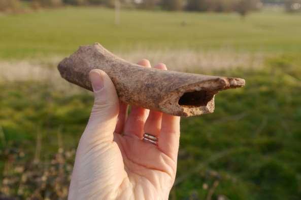
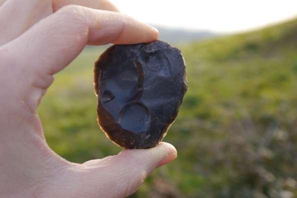
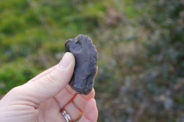
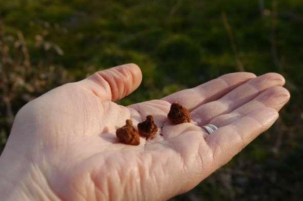
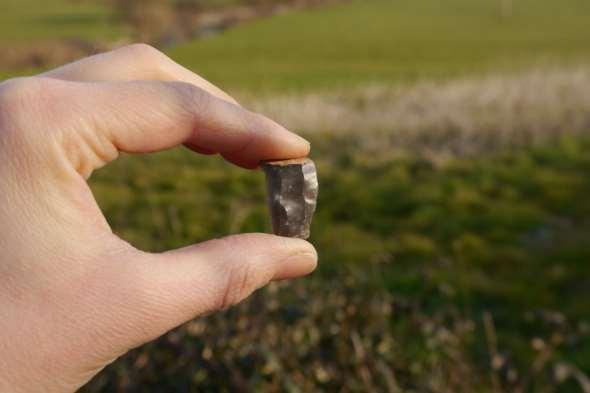
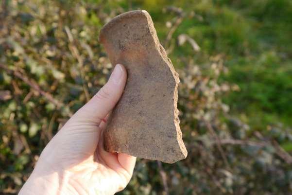
10 Resource 3 Object description Photo 1 Photo 2 Photo 3 Photo 4 Photo 5 Photo 6 Photo 7 A broken piece of pottery dating from the Iron Age. It would have been part of a large bowl probably used for storage. There is a distinctive zig-zag decoration at the top and the smooth burnished surface would have been made by rubbing it with a stone. The hole that is visible was drilled after the pot had been fired and may have been used to hang the bowl. A fragment of animal bone from an unknown date. Its large size and long shape suggest it is from the leg of a large animal (similar in size to a large pig or cow). It has been broken at both ends in the past. This could be a sign of butchery. The bone could be examined for further butchery marks such as cuts on the surface, and compared to a reference collection for species identification. A flint scraper dating from the Neolithic. It would have been made from a large piece of flint which flakes were struck from. The edge of the scraper has had small flakes removed from it to make it suitable for cleaning or working leather, wood and bone. The edge of the Neolithic scraper showing were small flakes have been removed creating the scraping edge. Three iron hobnails of Roman date. They have rusted overtime and an x-ray could be used to show their original shape more clearly. They (and lots more like them) would be fixed to the sole of a Roman soldier s shoe to provide grip. Part of a flint blade of probable Neolithic date. The regular shape of the blade shows that the flint nodule it was made from was carefully prepared by the planned removal of flakes before the blade itself was struck from it. It would be used as a knife for cutting meat, leather or wood amongst other things. Many flint blades (and other tools) have tiny flakes removed along the cutting edge called retouch. This is where the blade has been effectively re-sharpened and creates an almost serrated effect. A fragment (or sherd) of pottery from the Neolithic. It is a large sherd with the top edge of the pot surviving. The size of the pot can be estimated by looking closely at the curve of the rim. Analysing the fabric (type of clay and any additives such as grog, stone or organic temper) can help identify where and when the pottery was made. Please note, the objects photographed above were not found at Hembury. They are being used for illustrative purposes for the lesson and are examples of the types of artefacts you would expect to find at Hembury based on previous archaeological excavations. 10
11 Resource 4 The Role of an Archaeologist The role of an archaeologist is very varied. Archaeologists are normally associated with digging items out of the ground, but excavation is only one aspect of archaeology. Archaeologists also, for example, look at aerial photographs and maps to find clues about past landscapes, they carefully analyse excavated finds, they investigate old buildings, they use a range of dating techniques to find out how old things are and they use remote sensing to help them investigate what is underneath the ground without having to dig it up. They use all these techniques and others to gather evidence together to build up a picture of the past. Below is a list of a few simple activities that begin to give an insight into how archaeologists find out about the past. Depending on the time available, you may just want to describe the role of an archaeologist or use some of the activities below to provide more concrete examples. Activity ideas Mini excavation Fill a tray with a layer of sand and place some small items (coin, ring, dice, shell, small toy etc) in the sand for the children to excavate. Cover the layer of sand with soil and place more items in the soil layer. Keep a list of the items you put in each layer. Explain to the children that archaeologists excavate carefully, taking one layer of soil away at a time keeping all the finds from each layer separate. Ask the children to carefully remove the soil layer, ensuring they do not remove any of the sand. Archaeologists normally use trowels but spoons make a good alternative for excavation in the classroom. Explain that the children need to keep any of the finds from the soil in one place. They then need to carefully excavate the sand layer keeping the finds from the sand separate. When then have finished, the children can then compare the finds with the list of where the finds were put. If the children have excavated carefully, then all the finds from the soil layer should match the soil finds list and similarly the finds from the sand should match those on the sand layer list. Explain to the children that if they were excavating a real site, the finds from the bottom sand layer would be older than the finds from the top layers as they must have been dropped/ placed in sand before the soil built up on top. Exploring aerial photographs Aerial photographs allow archaeologists to look at wide areas of the landscape and place archaeological sites within their wider context. They are also used to identify new sites that can be difficult to see on the ground. Unusual shapes and features such as crop marks and earthworks often provide clues about what the landscape looked like in the past. 11
12 Look at your school using google earth (or equivalent) and ask the children to identify key features of the school. Can they see their classroom, field, school gates? Is there anything that they do not recognise? Are there any marks on the ground that they cannot identify? Zoom out from looking at the school and see what else is in the surrounding landscape. Ask the children to think about why their school is where it is? Is it in the middle of a village? Is it on the edge of a town? Is it close to where lots of houses are and therefore where lots of people live? How far away is it from another school? By looking at buildings across a landscape, we can begin to work out why they have been built in different locations. Similarly, by looking at archaeological sites in the landscape, we might begin to understand why they have been located in certain places. What survives in the ground? Gather together a selection of items made from a variety of materials such stone, clay, metal, bone, glass, leather, wood, and some food items. Ask the class to separate them into two groups: items that they think would survive in the ground and items that would rot away. Explain that archaeologists mainly find stone, clay, metal, glass and bone as these are items that do not decompose in the ground. The other items are only preserved in special conditions such as waterlogged, frozen, very dry or charred in a fire and turned to carbon. As a result, archaeologists are only working with a partial record and have to piece together clues to make an interpretation of the past. Much like trying to work out what a jigsaw looks like when over half the pieces are missing. Ask the children to think about what they are wearing at the moment. If we were buried with everything that we are wearing at the moment, what would survive if archaeologists excavated us 1000s of years later? (Metal buckles, zips and studs, metal jewellery such as rings, earrings and necklaces, parts of our mobile phones, our bones, teeth, metal fillings etc.) Would archaeologists be able to draw an exact picture of what you are wearing based on what they excavated? Piecing evidence together As mentioned above, archaeological evidence can be like a big jigsaw. Archaeologists have to put clues together and make their best interpretation of the past. There can be a range of interpretations and they can then change when new evidence is available. To demonstrate this process, cut up a picture or a piece of writing into several pieces and mix them up. Give the children one or two pieces and ask them to guess what the picture is or what the writing says. There will probably be a range of guesses, much like there is a range of interpretations of the past. Give the children a few more pieces and see if their guesses have changed. Carry on doing this until the picture or writing is complete and the children can see what was really there. 12

13 Resource 5 Aerial Photograph of Hembury Aerial Photograph of Hembury Hillfort taken in 1984 showing a small part of the large defensive ramparts and deep ditches. The rest are covered by trees. Frances Griffith, Devon County Council Look carefully at the aerial photograph, circle or highlight all the features that would not have been there in prehistoric times. Why did people choose to use Hembury during prehistoric and Roman periods? What do we use it for now? 13

14 Resource 6 Map of Hembury and Surrounding Area Crown Copyright and database right Ordnance Survey

15 Map of Hembury Crown Copyright and database right Ordnance Survey


16 Resource 7 Neolithic Finds from Hembury Bead 3,400 3,750 BC The bead is made from Kimmeridge shale. The rock is from south Dorset and is a soft rock that is easily shaped. The bead has two holes drilled through it to allow it be strung and used as jewellery. Beads are common in the Neolithic and could be made from stone, bones or even teeth Royal Albert Memorial Museum and Art Gallery, Exeter City Council b3.ashx Polished flint axehead 3,400 3,750 BC This axehead was made from a large piece of flint. It would have been held in a wooden handle and taken many hours to make. It probably would have been used to clear forests (due to the introduction of farming in the Neolithic) but they may also have been seen as high status symbols and used to show the importance of its owner Royal Albert Memorial Museum and Art Gallery, Exeter City Council 16


17 Flint blade 3,400 3,750 BC Flint knappers during the Neolithic were able to make many blades like this relatively quickly from one large piece of flint. The blade has a sharp cutting edge and could be held in wood and used to make a range of cutting tools Royal Albert Memorial Museum and Art Gallery, Exeter City Council ashx Grinding stone 3,400 3,750 BC The stone was used for grinding cereal grains into flour. The grains were placed in a bowl-shaped stone and then ground by moving this stone backwards and forwards over the top of them. This would have been an important daily activity in the Neolithic Royal Albert Memorial Museum and Art Gallery, Exeter City Council ashx 17


18 Cereal Grains 3,400 3,750 BC These are charred spelt grains, an ancient form of wheat. They were found in pits in the ground at Hembury and were grown by the first farmers in Devon. It is unusual for grains to survive in the ground but burning during the Neolithic transformed the grains into carbon and preserved them Royal Albert Memorial Museum and Art Gallery, Exeter City Council Sickle 3,400 3,750 BC This flint sickle blade would have been set into a curved wooden handle and used to cut cereal crops. The carefully worked flint blade has been broken and only part of it remains. The wooden handle has not been preserved Royal Albert Memorial Museum and Art Gallery, Exeter City Council 18


19 Leaf-shaped arrowhead 3,400 3,750 BC Leaf-shaped arrowheads were used for hunting animals and warfare. The arrowhead was attached to a shaft and fired from a bow. Many arrowheads were found around the main gate to the enclosure at Hembury which had been burnt. They may represent the earliest evidence for warfare in Devon Royal Albert Memorial Museum and Art Gallery, Exeter City Council Pottery 3,400 3,750 BC These are fragments of Neolithic pottery. They show a variety of handles and lug shapes. The holes may have been made to hold rope handles. Pottery was a new invention in the Neolithic. It was particularly important as it enabled people to store and cook food and materials Royal Albert Memorial Museum and Art Gallery, Exeter City Council


20 Pottery 3,400 3,750 BC This bowl was made from clay from the Lizard area of Cornwall. It is unclear whether the clay or the finished pot was transported to Hembury but it does show links with Cornwall Royal Albert Memorial Museum and Art Gallery, Exeter City Council p133.ashx Hazelnuts 3,400 3,750 BC These hazelnuts were found at Hembury and show that people relied on gathering wild foods from the surrounding countryside as well as farming. The hazelnuts were burnt during the Neolithic which turned them to carbon and preserved them. 20
 Sling Stones From Hembury Hillfort Many caches of river pebbles have")


21 Resource 8 Evidence from the Iron Age on Hembury Hillfort Photographs of finds from Hembury Hillfort displayed in the Iron Age cabinet at the Royal Albert Museum and Art Gallery (RAMM) Sling Stones From Hembury Hillfort Many caches of river pebbles have been found at Devon hillforts, probably used as sling stones. Text taken from display at the RAMM Bowl From Hembury Hillfort The shape and decoration of this bowl seems to be inspired by metal bowls. To achieve the surface sheen, the pot is burnished with a bone or stick. Text taken from display at the RAMM Glass Bead From Hembury Hillfort This type of bead could have belonged to the last prehistoric occupiers [Iron Age] of Hembury Hillfort or to the Roman invaders. Text taken from display at the RAMM 21
22 The quotes below have been taken from reports written by archaeologists about Hembury Hillfort. Some of the quotes contain technical language so you may need a dictionary to find the meaning for some of the words. The quotes below have been taken from reports written by archaeologists about Hembury Hillfort. Some of the quotes contain technical language so you may need a dictionary to find the meaning for some of the words. Part of a probable roundhouse was identified to the rear of the rampart and part of a smaller circular building lay to the west Todd, M., 1984, Excavations at Hembury (Devon) ; A Summary Report, (Article in Serial). SDV quantities of iron slag and ironstone suggest that this part of the site was used for metalworking. Todd, M., 1984, Excavations at Hembury (Devon) ; A Summary Report, (Article in Serial). SDV [There was a wide] rampart and two large ditches with three ditches across the neck of the promontory. There were entrances on the east and west sides with large timber gateways. Griffith, F. M., 1988, Devon's Past. An Aerial View, 24 (Monograph). SDV
23 Little is known, however, of the interior occupation of the hillfort. Part of a roundhouse was excavated close to the eastern rampart but no other Iron Age buildings were found in this area. No storage pits have been found. Finds of pottery and other artefacts has not been abundant suggesting that perhaps occupation was not prolonged. Griffith, F. M., 1988, Devon's Past. An Aerial View, 24 (Monograph). SDV64198 The location of the hillfort [has] extensive views over the Otter River valley and the surrounding countryside. Department for Culture, Media and Sport, 1998, Hembury Fort (Schedule Document). SDV The relatively flat interior of the hillfort is known to have supported at least one round house of 7 metres in diameter which was located near the eastern rampart. Department for Culture, Media and Sport, 1998, Hembury Fort (Schedule Document). SDV Excavations have revealed the presence of post holes representing the positions of timber revetments and palisades indicating that the entrances were well defended. Department for Culture, Media and Sport, 1998, Hembury Fort (Schedule Document). SDV
24 Pottery forms recovered in excavation, including upright jars and bowls decorated with curvilinear and geometric designs (Glastonbury Ware), confirmed the Iron Age occupation of the site. Department for Culture, Media and Sport, 1998, Hembury Fort (Schedule Document). SDV A small multivallate Iron Age hillfort on a narrow south facing promontory at the end of a 240 metre high ridge protruding from the Blackdown Hills chosen for its natural defensive qualities. Salvatore, J. P., 1998, Hembury Fort (Un-published). SDV At the north end an additional rampart and a 5 meter wide ditch extending for some 80 metres were added although they were never completed across the entire exposed neck of ground. Salvatore, J. P., 1998, Hembury Fort (Un-published). SDV The above extracts are from the Historic Environment Record (HER) monument description for Hembury and can be found at the Heritage Gateway The entrances were also inturned curving inwards to enable the trapping and attack of unwanted visitors? Frances Griffith, Devon County Council 24
25 Aerial photograph of Hembury Hillfort taken in 1984 showing a small part of the large defensive ramparts and deep ditches. The rest are covered by trees. A reconstruction drawing of what the Iron Age roundhouse found at Hembury Hillfort may have looked like. 25
26 Blackdown Hills AONB Partnership St Ivel House, Hemyock, Cullompton, Devon, EX15 3SJ The work of the Blackdown Hills AONB Partnership is funded by Defra, Devon and Somerset County Councils, East Devon, Mid Devon and South Somerset District Councils, and Taunton Dean Borough Council
A Sense of Place Tor Enclosures
 A Sense of Place Tor Enclosures Tor enclosures were built around six thousand years ago (4000 BC) in the early part of the Neolithic period. They are large enclosures defined by stony banks sited on hilltops
Moray Archaeology For All Project
 School children learning how to identify finds. (Above) A flint tool found at Clarkly Hill. Copyright: Leanne Demay Moray Archaeology For All Project ational Museums Scotland have been excavating in Moray
7. Prehistoric features and an early medieval enclosure at Coonagh West, Co. Limerick Kate Taylor
 7. Prehistoric features and an early medieval enclosure at Coonagh West, Co. Limerick Kate Taylor Illus. 1 Location of the site in Coonagh West, Co. Limerick (based on the Ordnance Survey Ireland map)
39, Walnut Tree Lane, Sudbury (SUY 073) Planning Application No. B/04/02019/FUL Archaeological Monitoring Report No. 2005/112 OASIS ID no.
 Planning Application No. B/04/02019/FUL Archaeological Monitoring Report No. 2005/112 OASIS ID no.") 39, Walnut Tree Lane, Sudbury (SUY 073) Planning Application No. B/04/02019/FUL Archaeological Monitoring Report No. 2005/112 OASIS ID no. 9273 Summary Sudbury, 39, Walnut Tree Lane, Sudbury (TL/869412;
39, Walnut Tree Lane, Sudbury (SUY 073) Planning Application No. B/04/02019/FUL Archaeological Monitoring Report No. 2005/112 OASIS ID no. 9273 Summary Sudbury, 39, Walnut Tree Lane, Sudbury (TL/869412;
Cambridge Archaeology Field Group. Fieldwalking on the Childerley Estate Cambridgeshire
 Cambridge Archaeology Field Group Fieldwalking on the Childerley Estate Cambridgeshire 2009 to 2014 Summary Fieldwalking on the Childerley estate of Martin Jenkins and Family has revealed, up to March
Test-Pit 3: 31 Park Street (SK )
") -Pit 3: 31 Park Street (SK 40732 03178) -Pit 3 was excavated in a flower bed in the rear garden of 31 Park Street, on the northern side of the street and west of an alleyway leading to St Peter s Church,
-Pit 3: 31 Park Street (SK 40732 03178) -Pit 3 was excavated in a flower bed in the rear garden of 31 Park Street, on the northern side of the street and west of an alleyway leading to St Peter s Church,
PREHISTORIC ARTEFACT BOX
 PREHISTORIC ARTEFACT BOX PREHISTORIC ARTEFACT BOX: COMPLETE BOX 1 Antler Retoucheur 11 Leather Cup 2 Flint Retoucheur 12 Flint Scrapers [1 large & 4 x small] in pouch 3 Hammer Stone 13 Flint Arrowheads
Colchester Archaeological Trust Ltd. A Fieldwalking Survey at Birch, Colchester for ARC Southern Ltd
 Colchester Archaeological Trust Ltd A Fieldwalking Survey at Birch, Colchester for ARC Southern Ltd November 1997 CONTENTS page Summary... 1 Background... 1 Methods... 1 Retrieval Policy... 2 Conditions...
Archaeological Material From Spa Ghyll Farm, Aldfield
 Archaeological Material From Spa Ghyll Farm, Aldfield Introduction Following discussions with Linda Smith the Rural Archaeologist for North Yorkshire County Council, Robert Morgan of 3D Archaeological
The Living and the Dead
 The Living and the Dead Round Barrows and cairns The transition from the late Neolithic to the early Bronze Age is traditionally associated with an influx of immigrants to the British Isles from continental
Fort Arbeia and the Roman Empire in Britain 2012 FIELD REPORT
 Fort Arbeia and the Roman Empire in Britain 2012 FIELD REPORT Background Information Lead PI: Paul Bidwell Report completed by: Paul Bidwell Period Covered by this report: 17 June to 25 August 2012 Date
Cambridge Archaeology Field Group. Fieldwalking on the Childerley Estate, Cambridgeshire. Autumn 2014 to Spring Third interim report
 Cambridge Archaeology Field Group Fieldwalking on the Childerley Estate, Cambridgeshire Autumn 2014 to Spring 2015 Third interim report Summary Field walking on the Childerley estate of Martin Jenkins
Bronze Age 2, BC
 Bronze Age 2,000-600 BC There may be continuity with the Neolithic period in the Early Bronze Age, with the harbour being used for seasonal grazing, and perhaps butchering and hide preparation. In the
I MADE THE PROBLEM UP,
 This assignment will be due Thursday, Oct. 12 at 10:45 AM. It will be late and subject to the late penalties described in the syllabus after Friday, Oct. 13, at 10:45 AM. Complete submission of this assignment
SALVAGE EXCAVATIONS AT OLD DOWN FARM, EAST MEON
 Proc. Hants. Field Club Archaeol. Soc. 36, 1980, 153-160. 153 SALVAGE EXCAVATIONS AT OLD DOWN FARM, EAST MEON By RICHARD WHINNEY AND GEORGE WALKER INTRODUCTION The site was discovered by chance in December
St Germains, Tranent, East Lothian: the excavation of Early Bronze Age remains and Iron Age enclosed and unenclosed settlements
 Proc Soc Antiq Scot, 128 (1998), 203-254 St Germains, Tranent, East Lothian: the excavation of Early Bronze Age remains and Iron Age enclosed and unenclosed settlements Derek Alexander* & Trevor Watkinsf
3. The new face of Bronze Age pottery Jacinta Kiely and Bruce Sutton
 3. The new face of Bronze Age pottery Jacinta Kiely and Bruce Sutton Illus. 1 Location map of Early Bronze Age site at Mitchelstown, Co. Cork (based on the Ordnance Survey Ireland map) A previously unknown
Lanton Lithic Assessment
 Lanton Lithic Assessment Dr Clive Waddington ARS Ltd The section headings in the following assessment report refer to those in the Management of Archaeological Projects (HBMC 1991), Appendix 4. 1. FACTUAL
An archaeological evaluation at the Lexden Wood Golf Club (Westhouse Farm), Lexden, Colchester, Essex
, Lexden, Colchester, Essex") An archaeological evaluation at the Lexden Wood Golf Club (Westhouse Farm), Lexden, Colchester, Essex January 2000 Archive report on behalf of Lexden Wood Golf Club Colchester Archaeological Trust 12 Lexden
An archaeological evaluation at the Lexden Wood Golf Club (Westhouse Farm), Lexden, Colchester, Essex January 2000 Archive report on behalf of Lexden Wood Golf Club Colchester Archaeological Trust 12 Lexden
Fieldwalking at Cottam 1994 (COT94F)
") Fieldwalking at Cottam 1994 (COT94F) Tony Austin & Elizabeth Jelley (19 Jan 29) 1. Introduction During the winter of 1994 students from the Department of Archaeology at the University of York undertook
Fieldwalking at Cottam 1994 (COT94F) Tony Austin & Elizabeth Jelley (19 Jan 29) 1. Introduction During the winter of 1994 students from the Department of Archaeology at the University of York undertook
Cetamura Results
 Cetamura 2000 2006 Results A major project during the years 2000-2006 was the excavation to bedrock of two large and deep units located on an escarpment between Zone I and Zone II (fig. 1 and fig. 2);
EARLY HISTORIC SCOTLAND
 EARLY HISTORIC SCOTLAND This artist s reconstruction of a crannog in a loch shows the stony platform on which the timber structures were built, and a small jetty at the gate. The main house here is round,
Latest archaeological finds at Must Farm provide a vivid picture of everyday life in the Bronze Age 14 July 2016
 Latest archaeological finds at Must Farm provide a vivid picture of everyday life in the Bronze Age 14 July 2016 Simplified schematic representation of a typical house at the Must farm settlement. The
An early pot made by the Adena Culture (800 B.C. - A.D. 100)
") Archaeologists identify the time period of man living in North America from about 1000 B.C. until about 700 A.D. as the Woodland Period. It is during this time that a new culture appeared and made important
Archaeologists identify the time period of man living in North America from about 1000 B.C. until about 700 A.D. as the Woodland Period. It is during this time that a new culture appeared and made important
A Fieldwalking Project At Sompting. West Sussex
 by John Funnell Introduction A Fieldwalking Project At Sompting. West Sussex During March -and April 1995 the Brighton and Hove Archaeological Society conducted fie1dwa1king in a field at Sompting West
Grim s Ditch, Starveall Farm, Wootton, Woodstock, Oxfordshire
 Grim s Ditch, Starveall Farm, Wootton, Woodstock, Oxfordshire An Archaeological Recording Action For Empire Homes by Steve Ford Thames Valley Archaeological Services Ltd Site Code SFW06/118 November 2006
PART 2 TEACHERS NOTES GO ROMAN THEME 3: OFF DUTY LET S INVESTIGATE NOTES AND OBJECT CHECKLIST
 PART 2 TEACHERS NOTES GO ROMAN THEME 3: LET S INVESTIGATE NOTES AND OBJECT CHECKLIST GO ROMAN THEME 3: When on duty, the soldiers were occupied with training, patrolling the Wall and carrying out maintenance
A visit to the Wor Barrow 21 st November 2015
 A visit to the Wor Barrow 21 st November 2015 Following our exploration of Winkelbury a few weeks previously, we fast forwarded 12 years in Pitt Rivers remarkable series of excavations and followed him
LE CATILLON II HOARD. jerseyheritage.org Association of Jersey Charities, No. 161
 LE CATILLON II HOARD CELTIC TRIBES This is a picture of the tribal structure of the Celtic Society CELTIC TRIBES Can you see three different people in the picture and suggest what they do? Can you describe
An archaeological evaluation at 16 Seaview Road, Brightlingsea, Essex February 2004
 An archaeological evaluation at 16 Seaview Road, Brightlingsea, Essex February 2004 report prepared by Kate Orr on behalf of Highfield Homes NGR: TM 086 174 (c) CAT project ref.: 04/2b ECC HAMP group site
ARCHAEOLOGICAL EVALUATION AT BRIGHTON POLYTECHNIC, NORTH FIELD SITE, VARLEY HALLS, COLDEAN LANE, BRIGHTON. by Ian Greig MA AIFA.
 ARCHAEOLOGICAL EVALUATION AT BRIGHTON POLYTECHNIC, NORTH FIELD SITE, VARLEY HALLS, COLDEAN LANE, BRIGHTON by Ian Greig MA AIFA May 1992 South Eastern Archaeological Services Field Archaeology Unit White
16 members of the Fieldwalking Group met York Community Archaeologist Jon Kenny at Lou Howard s farm, Rose Cottage Farm, at
 Terrington History Group Fieldwalking Group Field 1 Final report 21 October 2011 - fieldwalking 16 members of the Fieldwalking Group met York Community Archaeologist Jon Kenny at Lou Howard s farm, Rose
The lithic assemblage from Kingsdale Head (KH09)
") 1 The lithic assemblage from Kingsdale Head (KH09) Hannah Russ Introduction During excavation the of potential Mesolithic features at Kingsdale Head in 2009 an assemblage of flint and chert artefacts were
1 The lithic assemblage from Kingsdale Head (KH09) Hannah Russ Introduction During excavation the of potential Mesolithic features at Kingsdale Head in 2009 an assemblage of flint and chert artefacts were
Advanced archaeology at the archive. Museum of London Support materials AS/A2 study day
 Advanced archaeology at the archive Support materials AS/A2 study day Contents National Curriculum links and session description 1-2 Example timetable 3 Practical guidelines 4 Visit preparation and pre-visit
Archaeological sites and find spots in the parish of Burghclere - SMR no. OS Grid Ref. Site Name Classification Period
 Archaeological sites and find spots in the parish of Burghclere - SMR no. OS Grid Ref. Site Name Classification Period SU45NE 1A SU46880 59200 Ridgemoor Farm Inhumation Burial At Ridgemoor Farm, on the
An archaeological evaluation in the playground of Colchester Royal Grammar School, Lexden Road, Colchester, Essex
 An archaeological evaluation in the playground of Colchester Royal Grammar School, Lexden Road, Colchester, Essex February 2002 on behalf of Roff Marsh Partnership CAT project code: 02/2c Colchester Museum
Teachers Pack
 Whitehorse Hill: A Prehistoric Dartmoor Discovery 13.09.14-13.12.14 Teachers Pack CONTENTS About the Teachers Pack 05 Introduction to the exhibition 05 Prehistoric Britain - Timeline 05 What changed? Technology,
IRAN. Bowl Northern Iran, Ismailabad Chalcolithic, mid-5th millennium B.C. Pottery (65.1) Published: Handbook, no. 10
 Published: Handbook, no. 10") Bowl Northern Iran, Ismailabad Chalcolithic, mid-5th millennium B.C. Pottery (65.1) IRAN Published: Handbook, no. 10 Bowl Iran, Tepe Giyan 2500-2000 B.C. Pottery (70.39) Pottery, which appeared in Iran
Bowl Northern Iran, Ismailabad Chalcolithic, mid-5th millennium B.C. Pottery (65.1) IRAN Published: Handbook, no. 10 Bowl Iran, Tepe Giyan 2500-2000 B.C. Pottery (70.39) Pottery, which appeared in Iran
Changing People Changing Landscapes: excavations at The Carrick, Midross, Loch Lomond Gavin MacGregor, University of Glasgow
 Changing People Changing Landscapes: excavations at The Carrick, Midross, Loch Lomond Gavin MacGregor, University of Glasgow Located approximately 40 kilometres to the south-west of Oban, as the crow flies
STONES OF STENNESS HISTORIC ENVIRONMENT SCOTLAND STATEMENT OF SIGNIFICANCE
 Property in Care (PIC) ID: PIC321 Designations: Scheduled Monument (SM90285); Taken into State care: 1906 (Guardianship) Last reviewed: 2003 HISTORIC ENVIRONMENT SCOTLAND STATEMENT OF SIGNIFICANCE STONES
1 INTRODUCTION 1. Show the children the Great Hall Finds.
 This second activity in the How do archaeologists know these are royal sites? section follows on from the first, but can also be used as a stand-alone activity. This activity takes the children through
New Composting Centre, Ashgrove Farm, Ardley, Oxfordshire
 New Composting Centre, Ashgrove Farm, Ardley, Oxfordshire An Archaeological Watching Brief For Agrivert Limited by Andrew Weale Thames Valley Archaeological Services Ltd Site Code AFA 09/20 August 2009
Novington, Plumpton East Sussex
 Novington, Plumpton East Sussex The Flint Over 1000 pieces of flintwork were recovered during the survey, and are summarised in Table 0. The flint is of the same types as found in the previous survey of
Neolithic and Roman remains on the Lufkins Farm reservoir site, Great Bentley, Essex October-November 2007
 Neolithic and Roman remains on the Lufkins Farm reservoir site, Great Bentley, Essex report prepared by Howard Brooks and Ben Holloway on behalf of A O Poole & Sons and George Wright Farms NGR: TM 0975
Education Pack for Junior Certificate History
 Education Pack for Junior Certificate History Introduction This education pack has been designed by the Brú na Bóinne guides as an aid for teachers and pupils of the Junior Certificate History syllabus.
The excavation of a coastal promontory fort at Porth y Rhaw, Solva, Pembrokeshire,
 Archaeologia Cambrensis 159 (2010), 53 98 The excavation of a coastal promontory fort at Porth y Rhaw, Solva, Pembrokeshire, 1995 98 By PETE CRANE and KENNETH MURPHY 1 with contributions by A. E. Caseldine
Greater London GREATER LONDON 3/606 (E ) TQ
 TQ") GREATER LONDON City of London 3/606 (E.01.6024) TQ 30358150 1 PLOUGH PLACE, CITY OF LONDON An Archaeological Watching Brief at 1 Plough Place, City of London, London EC4 Butler, J London : Pre-Construct
GREATER LONDON City of London 3/606 (E.01.6024) TQ 30358150 1 PLOUGH PLACE, CITY OF LONDON An Archaeological Watching Brief at 1 Plough Place, City of London, London EC4 Butler, J London : Pre-Construct
SCOTLAND. Belfast IRISH SEA. Dublin THE REPUBLIC OF IRELAND ENGLAND ENGLISH CHANNEL. Before and After
 ALL ABOUT BRITAIN This book tells the story of the people who have lived in the British Isles, and is packed with fascinating facts and f un tales. The British Isles is a group of islands that consists
Chapter 2. Remains. Fig.17 Map of Krang Kor site
 Chapter 2. Remains Section 1. Overview of the Survey Area The survey began in January 2010 by exploring the site of the burial rootings based on information of the rooted burials that was brought to the
Section Worked stone catalogue By Hugo Anderson-Whymark
 Section 4.11.2 Worked stone catalogue By Hugo Anderson-Whymark Table 4.67: Worked stone from Alfred s Castle. TR Ctxt SF No 1 1000 0 Weaponry Sling-shot Flint pebble 100 1 57 43 37 27 Iron Age 1 1160 0
Photographs. Unless otherwise acknowledged, all photographs are the property of Pearson Education, Inc.
 Photographs Every effort has been made to secure permission and provide appropriate credit for photographic material. The publisher deeply regrets any omission and pledges to correct errors called to its
An archaeological evaluation by trial-trenching at Playgolf, Bakers Lane, Westhouse Farm, Colchester, Essex
 An archaeological evaluation by trial-trenching at Playgolf, Bakers Lane, Westhouse Farm, Colchester, Essex commissioned by Mr Stephen Belchem on behalf of ADP Ltd. report prepared by Chris Lister Planning
BALNUARAN. of C LAVA. a prehistoric cemetery. A Visitors Guide to
 A Visitors Guide to BALNUARAN of C LAVA a prehistoric cemetery Milton of Clava Chapel (?) Cairn River Nairn Balnuaran of Clava is the site of an exceptionally wellpreserved group of prehistoric burial
Chapter 14. Unlocking the Secrets of Mohenjodaro
 Chapter 14 Unlocking the Secrets of Mohenjodaro Chapter 14 Unlocking the Secrets of Mohenjodaro What can artifacts tell us about daily life in Mohenjodaro? 14.1 Introduction The geography of the Indian
The Neolithic Spiritual Landscape
 The For the earliest inhabitants of the island, certain places had a special significance and these were often marked in some way to highlight the spiritual nature of the place. The earliest known religious
THE RAVENSTONE BEAKER
 DISCOVERY THE RAVENSTONE BEAKER K. J. FIELD The discovery of the Ravenstone Beaker (Plate Xa Fig. 1) was made by members of the Wolverton and District Archaeological Society engaged on a routine field
Silwood Farm, Silwood Park, Cheapside Road, Ascot, Berkshire
 Silwood Farm, Silwood Park, Cheapside Road, Ascot, Berkshire An Archaeological Watching Brief For Imperial College London by Tim Dawson Thames Valley Archaeological Services Ltd Site Code SFA 09/10 April
ARCHAEOLOGICAL MONITORING REPORT
 ARCHAEOLOGICAL MONITORING REPORT SCCAS REPORT No. 2009/324 Thorington Hall, Stoke by Nayland SBN 087 HER Information Date of Fieldwork: November 2009 - January 2010 Grid Reference: TM 0131 3546 Funding
Ancient Ireland. Mesolithic Neolithic Bronze Age Iron Age (Celts) Early Christian Ireland
 Early Christian Ireland") Ancient Ireland Mesolithic Neolithic Bronze Age Iron Age (Celts) Early Christian Ireland Stone Age Ireland The Mesolithic Period Middle Stone Age. 7000BC. First settlers. Ice Age sea levels lower as water
Ancient Ireland Mesolithic Neolithic Bronze Age Iron Age (Celts) Early Christian Ireland Stone Age Ireland The Mesolithic Period Middle Stone Age. 7000BC. First settlers. Ice Age sea levels lower as water
Grange Farm, Widmer End, Hughenden, Buckinghamshire
 Grange Farm, Widmer End, Hughenden, Buckinghamshire An Archaeological Evaluation for British Flora by Andy Taylor Thames Valley Archaeological Services Ltd Site Code GFH 05/63 July 2005 Summary Site name:
History Ch-4 (W.B Answer Key) Pakistan 2. The bricks were laid in an interlocking pattern and that made the walls strong.
 Pakistan 2. The bricks were laid in an interlocking pattern and that made the walls strong.") History Ch-4 (W.B Answer Key) W.B (pp-42, 43) 1. The site of Harappa is in the present day Pakistan. 2. How were the bricks of ancient settlement used? The bricks were laid in an interlocking pattern and
History Ch-4 (W.B Answer Key) W.B (pp-42, 43) 1. The site of Harappa is in the present day Pakistan. 2. How were the bricks of ancient settlement used? The bricks were laid in an interlocking pattern and
Bristol & Gloucestershire Archaeological Society
 Chris Hayden, Rob Early, Edward Biddulph, Paul Booth, Anne Dodd, Alex Smith, Granville Laws and Ken Welsh, Horcott Quarry, Fairford and Arkell's Land, Kempsford: Prehistoric, Roman and Anglo-Saxon settlement
T so far, by any other ruins in southwestern New Mexico. However, as
 TWO MIMBRES RIVER RUINS By EDITHA L. WATSON HE ruins along the Mimbres river offer material for study unequaled, T so far, by any other ruins in southwestern New Mexico. However, as these sites are being
Essex Historic Environment Record/ Essex Archaeology and History
 Essex Historic Environment Record/ Essex Archaeology and History CAT Report 578 Summary sheet Address: Kingswode Hoe School, Sussex Road, Colchester, Essex Parish: Colchester NGR: TL 9835 2528 Type of
Archaeological trial-trenching evaluation at Chappel Farm, Little Totham, Essex. April 2013
 Archaeological trial-trenching evaluation at Chappel Farm, Little Totham, Essex April 2013 report prepared by Ben Holloway commissioned by Tim Harbord Associates on behalf of Mr Tom Howie Planning reference:
An archaeological watching brief and recording at Brightlingsea Quarry, Moverons Lane, Brightlingsea, Essex October 2003
 An archaeological watching brief and recording at Brightlingsea Quarry, Moverons Lane, Brightlingsea, Essex commissioned by Mineral Services Ltd on behalf of Alresford Sand & Ballast Co Ltd report prepared
Hen Gastell, Llanwnda A Medieval Defended Site
 Hen Gastell, Llanwnda A Medieval Defended Site Summary of Excavation Report Ymddiriedolaeth Archaeolegol Gwynedd Gwynedd Archaeological Trust 47 46 48 Crown Copyright and database right 2016. Ordnance
2 Saxon Way, Old Windsor, Berkshire
 2 Saxon Way, Old Windsor, Berkshire An Archaeological Watching Brief For Mrs J. McGillicuddy by Pamela Jenkins Thames Valley Archaeological Services Ltd Site Code SWO 05/67 August 2005 Summary Site name:
Any Number of Effigy Mounds, Some of Them Artistic A Modern Indian s Bones- Finds of Pottery, Arrows and Stone Implements
 New York Times Prehistoric Wisconsin Ancient Mounds and Earth Works Lately Discovered Any Number of Effigy Mounds, Some of Them Artistic A Modern Indian s Bones- Finds of Pottery, Arrows and Stone Implements
Unit 6: New Caledonia: Lapita Pottery. Frederic Angleveil and Gabriel Poedi
 Unit 6: New Caledonia: Lapita Pottery Frederic Angleveil and Gabriel Poedi Facts Capital Main islands Highest point Language Government Noumea Grande Terre, 3 Loyalty Islands and numerous reefs and atolls
Inadvertent Discovery Plan (IDP)
") Inadvertent Discovery Plan (IDP) Permit Number: Project Name: Applicant: Property Address: As the project proponent, I have read this document in full and understand that: 1. I will follow the actions
Inadvertent Discovery Plan (IDP) Permit Number: Project Name: Applicant: Property Address: As the project proponent, I have read this document in full and understand that: 1. I will follow the actions
KNAP OF HOWAR HISTORIC ENVIRONMENT SCOTLAND STATEMENT OF SIGNIFICANCE. Property in Care (PIC) ID: PIC301 Designations:
 ID: PIC301 Designations:") Property in Care (PIC) ID: PIC301 Designations: Scheduled Monument (SM90195) Taken into State care: 1954 (Guardianship) Last reviewed: 2004 HISTORIC ENVIRONMENT SCOTLAND STATEMENT OF SIGNIFICANCE KNAP
Property in Care (PIC) ID: PIC301 Designations: Scheduled Monument (SM90195) Taken into State care: 1954 (Guardianship) Last reviewed: 2004 HISTORIC ENVIRONMENT SCOTLAND STATEMENT OF SIGNIFICANCE KNAP
Contact Details The Collection: Art & Archaelogoy in Lincolnshire Danes Terrace, Lincoln LN2 1LP Tel: +44 (0)
") Contact Details The Collection: Art & Archaelogoy in Lincolnshire Danes Terrace, Lincoln LN2 1L Tel: +44 (0)1522 550990 www.thecollectionmuseum.com Opening Times Open daily 10am - 4pm Free Entry For Investigate
Contact Details The Collection: Art & Archaelogoy in Lincolnshire Danes Terrace, Lincoln LN2 1L Tel: +44 (0)1522 550990 www.thecollectionmuseum.com Opening Times Open daily 10am - 4pm Free Entry For Investigate
Chapter 2: Archaeological Description
 Chapter 2: Archaeological Description Phase 1 Late Neolithic, c 3000-2400 BC (Figs 6-9) Evidence of Neolithic activity was confined to pits dug across the southern half of the site (Fig. 6). Eighteen pits
Artifacts. Antler Tools
 Artifacts Artifacts are the things that people made and used. They give a view into the past and a glimpse of the ingenuity of the people who lived at a site. Artifacts from the Tchefuncte site give special
An archery set from Dra Abu el-naga
 An archery set from Dra Abu el-naga Even a looted burial can yield archaeological treasures: David García and José M. Galán describe a remarkable set of bows and arrows from an early Eighteenth Dynasty
2.Valley bottom and hilltop: 6,000 years of settlement along the route of the N4 Sligo Inner Relief Road Michael MacDonagh
 2.Valley bottom and hilltop: 6,000 years of settlement along the route of the N4 Sligo Inner Relief Road Michael MacDonagh Illus. 1 Aerial view of archaeological test-trenches along the route of the N4
THE UNFOLDING ARCHAEOLOGY OF CHELTENHAM
 THE UNFOLDING ARCHAEOLOGY OF CHELTENHAM The archaeology collection of Cheltenham Art Gallery & Museum contains a rich quantity of material relating to the prehistoric and Roman occupation of the North
Wisconsin Sites Page 61. Wisconsin Sites
 Wisconsin Sites Page 61 Silver Mound-A Quarry Site Wisconsin Sites Silver Mound in Jackson County is a good example of a quarry site where people gathered the stones to make their tools. Although the name
Church of St Peter and St Paul, Great Missenden, Buckinghamshire
 Church of St Peter and St Paul, Great Missenden, Buckinghamshire An Archaeological Watching Brief for the Parish of Great Missenden by Andrew Taylor Thames Valley Archaeological Services Ltd Site Code
Hayling School, Church Road, Hayling Island, Hampshire
 Hayling School, Church Road, Hayling Island, Hampshire An Archaeological Evaluation for George Wimpey Southern Ltd by Helen Moore Thames Valley Archaeological Services Ltd Site Code HSHI 03/46 July 2003
Barnet Battlefield Survey
 In terim report on the progress of the Barnet Battlefield Survey December 2016 The Barnet Battlefield Survey is an archaeological investigation into the 1471 Battle of Barnet. It aims to define more accurately
An archaeological evaluation at Thistle Hall, Mope Lane, Wickham Bishops, Essex July 2009
 An archaeological evaluation at Thistle Hall, Mope Lane, Wickham Bishops, Essex July 2009 report prepared by Howard Brooks and Ben Holloway on behalf of Clarity Ecoworks Ltd CAT project ref.: 09/1f ECC
Built Heritage Inventory
 Castlecliff Pill Boxes Register Item Number: 91 Building Type: Residential Commercial Industrial Recreation Institutional Agriculture Other Location: Castlecliff Beach, Whanganui Heritage NZ Pouhere Taonga
Caistor Roman Project Interim Summary of 2015 Season of Test pits at Caistor Old Hall
 Caistor Roman Project Interim Summary of 2015 Season of Test pits at Caistor Old Hall Introduction This brief report summarises the first results of the 2015 campaign of test-pitting in the grounds of
The first men who dug into Kent s Stonehenge
 From: Paul Tritton, Hon. Press Officer Email: paul.tritton@btinternet.com. Tel: 01622 741198 The first men who dug into Kent s Stonehenge Francis James Bennett (left) and a colleague at Coldrum Longbarrow
DEMARCATION OF THE STONE AGES.
 20 HAMPSHIRE FLINTS. DEMARCATION OF THE STONE AGES. BY W, DALE, F.S.A., F.G.S. (Read before the Anthropological Section of -the British Association for the advancement of Science, at Birmingham, September
0. S. U. Naturalist. [Nov.
 4 0. S. U. Naturalist. [Nov. THE BAUM PREHISTORIC VILLAGE SITE. W, C. MILLS. The field work of the Ohio State Archaeological and Historical Society was completed August 18. The explorations were a continuance
An archaeological evaluation at the Blackwater Hotel, Church Road, West Mersea, Colchester, Essex March 2003
 An archaeological evaluation at the Blackwater Hotel, Church Road, West Mersea, Colchester, Essex report prepared by Laura Pooley on behalf of Dolphin Developments (U.K) Ltd NGR: TM 0082 1259 CAT project
Archaeological trial-trenching evaluation at Dale Hall, Cox s Hill, Lawford, Essex
 Archaeological trial-trenching evaluation at Dale Hall, Cox s Hill, Lawford, Essex Fieldwork directed by Ben Holloway report prepared by Howard Brooks with a contribution by Stephen Benfield on behalf
Azerbaijan National Academy of Sciences Institute of Archaeology and Ethnography. Safar Ashurov
 Azerbaijan National Academy of Sciences Institute of Archaeology and Ethnography Safar Ashurov Zayamchay Report On Excavations of a Catacomb Burial At Kilometre Point 355 of Baku-Tbilisi-Ceyhan and South
Ancient Chinese Chariots
 Reading Practice Ancient Chinese Chariots A The Shang Dynasty or Yin Dynasty, according to traditional historiography, ruled in the Yellow River valley in the second millennium. Archaeological work at
UNIVERSITY OF LANCASTER ARCHAEOLOGY CONFERENCE. 9 March 2002
 UNIVERSITY OF LANCASTER CENTRE FOR NORTH-WEST REGIONAL STUDIES ARCHAEOLOGY CONFERENCE 9 March 2002 A Chairman's Reflections - David Shotter Over the past thirty years, this Conference has become an established
Fieldwalk On Falmer Hill, Near Brighton - Second Season
 Fieldwalk On Falmer Hill, Near Brighton - Second Season by the Brighton and Hove Archaeological Society This report as well as describing the recent fieldwalks also includes descriptions of previous discoveries
STONE implements and pottery indicative of Late Neolithic settlement are known to
 Late Neolithic Site in the Extreme Northwest of the New Territories, Hong Kong Received 29 July 1966 T. N. CHIU* AND M. K. WOO** THE SITE STONE implements and pottery indicative of Late Neolithic settlement
Artefacts. Samian fragment Date: AD Found: Inner Ward excavation
 Artefacts This is from a high-status Roman bowl used for displaying and serving food. It was found during an excavation in the Inner Ward of the Tower, close to the modern Raven shop. The Tower of London
FURTHER MIDDLE SAXON EVIDENCE AT COOK STREET, SOUTHAMPTON (SOU 567)
") Roc. Hampshire Field Club Archaeol. Soc 52,1997, 77-87 (Hampshire Studies 1997) FURTHER MIDDLE SAXON EVIDENCE AT COOK STREET, SOUTHAMPTON (SOU 567) By M F GARNER andj VINCENT with a contribution byjacqueline
Roc. Hampshire Field Club Archaeol. Soc 52,1997, 77-87 (Hampshire Studies 1997) FURTHER MIDDLE SAXON EVIDENCE AT COOK STREET, SOUTHAMPTON (SOU 567) By M F GARNER andj VINCENT with a contribution byjacqueline
ST PATRICK S CHAPEL, ST DAVIDS PEMBROKESHIRE 2015
 ST PATRICK S CHAPEL, ST DAVIDS PEMBROKESHIRE 2015 REPORT FOR THE NINEVEH CHARITABLE TRUST THE UNIVERSITY OF SHEFFIELD AND DYFED ARCHAEOLOGICAL TRUST Introduction ST PATRICK S CHAPEL, ST DAVIDS, PEMBROKESHIRE,
Control ID: Years of experience: Tools used to excavate the grave: Did the participant sieve the fill: Weather conditions: Time taken: Observations:
 Control ID: Control 001 Years of experience: No archaeological experience Tools used to excavate the grave: Trowel, hand shovel and shovel Did the participant sieve the fill: Yes Weather conditions: Flurries
An archaeological watching brief at Sheepen, Colchester, Essex November-December 2003
 An archaeological watching brief at Sheepen, Colchester, Essex November-December 2003 report prepared by Ben Holloway on behalf of Colchester Borough Council CAT project ref.: 03/11c Colchester Museums