Mann Island Canal Link,
|
|
|
- Gwenda Rich
- 5 years ago
- Views:
Transcription


1 Mann Island Canal Link, Merseyside Archaeological Excavation Report Oxford Archaeology North February 2011 BAM Nuttall Ltd Issue No: /1167 OA North Job No: L10108 NGR: SJ
2
3 Mann Island Canal Link, Merseyside: Archaeological Excavation Report 1 CONTENTS SUMMARY...3 ACKNOWLEDGEMENTS INTRODUCTION Circumstances of the Project Site Location, Topography and Geology Previous Work METHODOLOGY Project Design Excavation and Watching Brief Updated Research Aims The Artefacts Archive Recipient Museum Discard Policy Dissemination BACKGROUND Historical Background EXCAVATION RESULTS Introduction Phase 1 (Mersey Foreshore: Medieval Mid-eighteenth Century) Phase 2 (Reclamation: Mid-eighteenth Century) Phase 3 (Development and Reclamation, Later Eighteenth Century) Phase 4 (Manchester Basin, Late Eighteenth Century) Phase 5 (Manchester Dock and Canning Dock, Early Nineteenth Century) Phase 6 (Manchester Dock Developments, Late Nineteenth Early Twentieth Century) Phase 7 ( ) THE FINDS Introduction The Artefacts Discussion...32
4 Mann Island Canal Link, Merseyside: Archaeological Excavation Report 2 6 DISCUSSION Introduction Reclamation Sea Walls Dock Walls Research Aims Conclusions...38 BIBLIOGRAPHY...39 Cartographic Sources...39 Secondary Sources...39 APPENDIX 1: POTTERY FABRICS...43 ILLUSTRATIONS...47 List of Figures...47 List of Plates...47
5 Mann Island Canal Link, Merseyside: Archaeological Excavation Report 3 SUMMARY Over the period , Oxford Archaeology North (OA North) carried out archaeological excavations in advance of the cutting of a new Canal Link, creating 1.4 miles of new navigable waterway along the banks of the river Mersey. The work on the southernmost section of the Canal, in the Mann Island area of Liverpool (centred at SJ ), was undertaken for BAM Nuttall Ltd, on behalf of BAM and British Waterways. To the north of this, work was carried out for Balfour Beatty Civil Engineering Ltd, and Pierse Ltd, at Pier Head and the Central Docks, respectively. These latter works are subject to separate reports. The development footprint forms a significant part of the Mann Island area to the south of the Port of Liverpool Building, Cunard Building and Liver Building. The site lies within the Liverpool Maritime Mercantile City World Heritage Site, and is also classed as a conservation zone. It includes the remains and sites of eighteenth-century sea walls, Manchester Dock, Canning Dock, and eighteenth- and nineteenth-century warehouses. The excavation revealed details of both the known major monuments, and additional structures which do not feature on maps and had not been documented previously. Several sea walls were exposed, along with temporary walls, which provided long- and short-term sea defences, at interim stages in the progress of land reclamation. The walls appeared to have survived in near-perfect condition and almost to their full height of c 5m. Manchester Dock, and its associated warehouses, survived in excellent condition, less than 1m below the modern ground surface, along with evidence for earlier quaysides. In addition, a section of Canning Dock, which is still in operation, was excavated and examined. This revealed the buttressing behind the dock wall. The stone used in the construction of the dock and sea walls varied, with yellow sandstone used for the sea walls, while the docks were built from the less brittle pink variety. The excavation results add significantly to what was known and understood about the form and technology of some of Liverpool s most notable maritime engineering structures.
6 Mann Island Canal Link, Merseyside: Archaeological Excavation Report 4 ACKNOWLEDGEMENTS Oxford Archaeology North wishes to thank BAM Nuttall Ltd and British Waterways for commissioning the project. Sincere thanks go to all of the BAM Nuttall Ltd construction team, including Terry Nuttall, Tony Wilkes, Dan Davies, and Alan Bennett, for their continual on-site support, as well as Owen and all the site staff who worked alongside the archaeologists. Many thanks are offered to all the British Waterways staff involved in the project, including Richard Longton, Tim Brownrigg, Charles Wilsoncroft and Ian Thomas, for all their help and support. Thanks also go to the ARUP team: Richard Summers, Lyndsey Hammond and Miles Wilkinson. We would also like to thank Sarah-Jane Farr, the Merseyside Archaeological Officer, for providing information and support throughout the course of the excavation. Similarly, we would like to thank Rob Philpott and Mark Adams of National Museums Liverpool and Adrian Jarvis of the University of Liverpool s Centre for Port and Maritime History for their support, and for information willingly given during the course of the excavation. The excavation work was undertaken by Vix Hughes and Caroline Raynor, with the assistance of Ric Buckle, Tim Christian, Pascal Eloy, Joanne Hawkins, Pip Haworth, Paul Holmes, Tom Mace, Dave Lamb, Des O Leary, Kieran Power, Andy Proctor and Elizabeth Murray. We would like to thank David Higgins for his specialist report on the clay pipes, and he is particularly grateful to Ron Dagnall of Rainford for providing him with transcriptions of documents relating to Thomas Hayes, and to Susie White, who prepared the majority of the archival pipe illustrations. Dr Higgins also wishes to thank Jan van Oostveen from the Netherlands for his help with dating the Gouda stem stamp. This report was compiled by Nick Johnson and edited by Rachel Newman, and the drawings were produced by Anne Stewardson and Caroline Raynor.
7 Mann Island Canal Link, Merseyside: Archaeological Excavation Report 5 1 INTRODUCTION 1.1 CIRCUMSTANCES OF THE PROJECT Oxford Archaeology North (OA North) was appointed to undertake the archaeological works for the entire length of the proposed Liverpool Canal Link project, which has been designed by British Waterways. This involved the undertaking of watching briefs and large-scale excavations on the archaeologically sensitive sections of the route. The purpose of the commissions was to mitigate any adverse effect the construction of the Canal might have on the cultural heritage of Liverpool. BAM Nuttall Ltd held the contract for the southernmost section of the Link, known as Mann Canal, which lies on Mann Island, and joins Canning Dock to Pier Head, and this company commissioned OA North for this section of the project. This section had previously been evaluated, when a series of trenches indicated the excellent survival of buried archaeological features, but relatively close to the surface (OA North 2006a). This report presents the results of the archaeological evaluation, excavation, and watching brief, undertaken over the period , following the analysis of the material excavated. 1.2 SITE LOCATION, TOPOGRAPHY AND GEOLOGY The site lies on reclaimed land, west of the former Mersey shoreline, which is marked today by the course of The Strand (Fig 1). It is bounded to the north by the road called Mann Island, which runs westwards from The Strand and provides access to Pier Head. The south-eastern boundary is formed by Canning Dock (SJ ), while Canning Graving Dock 3 marks the southern edge (SJ ). For management and construction purposes, the whole length of the Canal was divided into a number of sections, numbered from south to north, as far as Princes Dock (SJ ), as LCL1 8, while the northern part was numbered from north to south, as LCD1 7. Mann Canal occupied sections designated LCL1 3 (Fig 1) Mann Island, south of the Port of Liverpool Building, is part of the Maritime Mercantile City of Liverpool World Heritage Site (Fig 1), and is a designated Conservation Area. It was reclaimed from the river during the development of the port in the eighteenth century, and now forms a uniform plateau, at 6m OD The drift geology of this part of Liverpool includes alluvium and intermixed silts and sands along the estuarine margins of the Mersey, which used to reach as far as The Strand (Philpott 1999). Mann Island consists mainly of made-ground, cartographic evidence showing that it mostly post-dates 1769 (Perry 1769), along with the formation further north at Pier Head, although a major phase of reclamation from the Mersey was initiated c 1740, with the construction of the Dry Dock, sometimes known as the Dry Pier (Plate 1), west of the Old Dock (Ritchie-Noakes 1984, 19). The Old Dock itself, the first commercial wet dock in the world, was constructed , and extended to 3½ acres (ibid). The rapid increase in trade through Liverpool, coupled with its seasonality, soon meant that the dock was severely crowded. Its entrance was narrow, and usable only at the higher states of the
8 Mann Island Canal Link, Merseyside: Archaeological Excavation Report 6 tide. As a result, ships were often unable to leave the Old Dock when ready to sail (op cit, 21). The expansion of Mann Island, which allowed the construction of Dry Dock, was a direct consequence of the success and technological constraints of the Old Dock. Since the mid-eighteenth century, the site has been heavily used, substantially remodelled, and densely occupied (Jarvis 1996). 1.3 PREVIOUS WORK An impact assessment was prepared by Wardell Armstrong on behalf of British Waterways, in which the archaeological value of the dockland remains was recognised (Wardell Armstrong 2003). In 2005, Wardell Armstrong prepared a brief for a mitigating archaeological investigation, which emphasised that the canal project presents a unique opportunity to gain considerable and valuable information which will greatly improve our understanding of the dock development (Wardell Armstrong 2005, 4). This formed the basis of a project design for evaluation, watching brief and excavation submitted by OA North (OA North 2006b) The first phase of below-ground archaeological investigation along the route of the Liverpool Canal Link consisted of the excavation of seven evaluation trenches. Three of these lay in the area of the Mann Island section (OA North 2006a), ie Trenches 401, 402 and 403, and were positioned specifically to test the survival of the Manchester Dock (Fig 2) Trench 401 revealed the eastern wall of the dock, while the southern and northern walls were uncovered in Trenches 402 and 403, respectively. In all three cases, survival was excellent, with the top course of the dock wall extant, close to the present ground surface. In addition, ancillary structures and fittings were also identified, including the east gable of one of several buildings owned and operated by the Great Western Railway on the north side of the dock (shown in Ritchie-Noakes 1984, 35, pl 23), a lamp-post base, and a dock ladder The evaluation report (OA North 2006a) made specific proposals for future archaeological works, encompassing a range of strategies appropriate to the significance of the archaeological remains likely to be encountered in different areas of the development footprint. A revised project design for further excavation and a watching brief was issued in late 2006 (OA North 2006c).
9 Mann Island Canal Link, Merseyside: Archaeological Excavation Report 7 2 METHODOLOGY 2.1 PROJECT DESIGN Following a request from British Waterways, a Project Design was developed (OA North 2006b), outlining methodologies designed to mitigate the impact on archaeological remains arising from the construction of the Canal. Building on the results of the impact assessment and the evaluation (OA North 2006a), the significance of the archaeological features known and thought to be preserved was assessed, and appropriate levels of investigation and recording specified The overall aim of the mitigating works was to provide an appropriate, specialist response to known or newly discovered archaeological remains during the course of construction, including the recording of archaeological and structural features, with particular attention paid to those features considered particularly significant, for instance, the walls of Canning Dock, a Grade II listed structure, and other dock and sea walls. This would serve the aim of enhancing knowledge about the development of the Liverpool docks (Wardell Armstrong 2005) A series of research questions was formulated: what techniques were employed in the construction of the various docks, and were particular techniques characteristic of a specific engineer? what is the evidence for earlier dock structures? what is the evidence for buildings associated with the docks, and ancillary fittings and furniture? 2.2 EXCAVATION AND WATCHING BRIEF The results of the desk-based assessment and evaluation (OA North 2006a) had implied that the south-eastern corner of the development site was likely to preserve the greatest quantity and complexity of archaeological material. Excavation of this area commenced in August 2007, and entailed the removal of the upper 2m-depth of deposits by machine and hand, before the bulk removal of material by machine to the formation level of the Canal Apart from this section in the south-east corner, the majority of the Canal route within Mann Island cut through the area formerly occupied by the Manchester Dock, which was backfilled in the period , using spoil from the excavation of the Mersey Tunnel (Ritchie-Noakes 1984, 36). An archaeological watching brief was maintained during the bulk excavation of the Canal formation The sheets for field recording utilised a format acceptable to the Institute for Archaeologists (IfA 1995), a unique alpha-numeric project code being applied to all records. All archaeological features were accurately located on a site plan and recorded by
10 Mann Island Canal Link, Merseyside: Archaeological Excavation Report 8 photographs, scale drawings and written descriptions, in accordance with the Brief (Wardell Armstrong 2005, 5 et seq). The evaluation trenches and open-area excavation were accurately surveyed, tied into the Ordnance Survey (OS) datum, and located on an up-to-date 1:1250 OS map base (Fig 2). Artefacts were retained for processing and analysis. An extensive digital and analogue photographic archive was built up, recording the progress of the excavations and details of significant features. The resulting artefactual, paper and digital archive has been prepared for deposition in accordance with the aims and objectives set out in the revised project design (OA North 2010a, 10). 2.3 UPDATED RESEARCH AIMS The revised project design (OA North 2010a, 27) updated and added to the original research aims and objectives. These were formulated in accordance with the guidance of English Heritage (English Heritage 1991, 2 3), and were as follows: Updated research aim 1: how did the environment of the river Mersey foreshore and its human use develop over time? Objective 1: to examine the early environment of the river Mersey, including evidence for early sea level and vegetational changes. Objective 2: to examine the nature of post-medieval exploitation of the river Mersey, including evidence for the changing shoreline and land surfaces Updated research aim 2: how did the layout and character of the site develop through the post-medieval period? Objective 1: to characterise the nature of the main phases of activity via their stratigraphy and to detail the archaeological formation of the sites. Objective 2: to determine the phasing of the structures to set their development within an historical context Updated research aim 3: what is the evidence for the development of trade and industry in post-medieval Liverpool, and its associated infrastructure? Objective 1: to examine the contribution of the docks to the development of Liverpool s production, industry, trade and transport. Objective 2: to explore the evidence for the rise of consumerism. Objective 3: to integrate evidence for the wider development of transport and industrial infrastructure in Liverpool with the evidence for goods, trades and services provided by the artefacts and structures located by the excavation Updated research aim 4: what evidence is there for developments in engineering and methodology in Liverpool s dock system? Objective 1: to detail the construction methods and materials, including adaptations and rebuilds, for all the maritime features within the site. Objective 2: to investigate the dock system, its development and use, examining the evidence for the Liverpool docks and those in other global port cities.
11 Mann Island Canal Link, Merseyside: Archaeological Excavation Report THE ARTEFACTS The revised project design (OA North 2010a) confirmed the likely value of post-excavation analysis on specific categories of finds, particularly the pottery, the ceramic building material, the clay tobacco pipe, the metalwork, and the glass. Each category was analysed by a specialist, with the aim of extracting the information anticipated in the revised project design, and in accordance with the methodologies outlined in that document (OA North 2010). 2.5 ARCHIVE A full archive, produced to professional standards, has been prepared, in accordance with current English Heritage guidelines (English Heritage 1991) and both Environmental standards for the permanent storage of excavated material from archaeological sites (UKIC 1984, Conservation Guidelines 3) and Guidelines for the Preparation of Excavation Archives for Long Term Storage (Walker 1990), now that the project is complete. The project archive collates and indexes all the data and material gathered during the course of the project. The deposition of a properly ordered and indexed project archive in an appropriate repository is considered an essential and integral element of all archaeological projects by the IfA in that organisation s code of conduct. The archive will be deposited with National Museums Liverpool, which meets the criteria of the Museums, Libraries and Archives Council for the long-term storage of archaeological material (Museums and Galleries Commission 1992) Structural and Stratigraphic data: the context record generated by the excavation, which forms part of the site archive, describes 120 contexts in total. The archive of primary field drawings and photographs comprises the following: Multiple context plans 104 Laser scans 6 Monochrome contact prints 330 Slides 330 Digital images The digital data has been temporarily stored on the server at OA North, which is backed up on a daily basis. CDs are being used for long-term storage of the digital data, the content including the reports, plans, scanned images and digital photographs. Each CD is fully indexed and is accompanied by the relevant metadata for provenance All dry and stable finds have been packed according to the Museum s specifications, in either acid-free cardboard boxes, or in airtight plastic boxes for unstable material. Each box has a list of its contents and in general contains only one type of material, such as pottery or glass The assemblage is currently well-packaged, and box lists derived from the site database have been compiled. The paper records are in acid-free storage, fully indexed, and with the contents labelled.
12 Mann Island Canal Link, Merseyside: Archaeological Excavation Report RECIPIENT MUSEUM National Museums Liverpool is a group of eight museums in Liverpool, including the Merseyside Maritime Museum and the Museum of Liverpool Life. The main museum has been nominated as having the capacity to co-ordinate the deposition of the finds and the paper and electronic archive. Paper and digital copies of issued reports will be deposited with the Liverpool Record Office. Site Code: LC(N) 07. National Museums Liverpool, William Brown Street, Liverpool, L3 8EN. Contact: Liz Stewart. Tel (switchboard). Liverpool Record Office, Central Library, William Brown Street, Liverpool, L3 8EW. Tel DISCARD POLICY A Discard Policy has been prepared, in consultation with the recipient museum, National Museums Liverpool. Material of no discernible long-term archaeological potential has been discarded, with the Museum's agreement. 2.8 DISSEMINATION In accordance with the project Brief (Wardell Armstrong 2005), and following consultation with the client and the Merseyside Archaeologist, a suitable text will be prepared to publish the results from the excavation in an appropriate journal A synthesis (in the form of the index to the archive and a copy of this report) will be deposited with the Merseyside Historic Environment Record. A copy of the index to the archive will also be available for deposition in the National Monument Record in Swindon.
13 Mann Island Canal Link, Merseyside: Archaeological Excavation Report 11 3 BACKGROUND 3.1 HISTORICAL BACKGROUND The development of the docks at Liverpool exploited the natural geographical advantages of the Mersey, but also had to overcome the disadvantages presented by that same watercourse. Prior to the rise of Liverpool, the premier port for the North West was Chester, on the river Dee. Thirteenth-century Chester, however, was struggling with the rapid silting of the Dee (Hudson 1999, 61), and King John did not wish to be dependent on its already significantly powerful Earl, Ranulf de Blondeville (Higham 2004, 150), in the pursuit of his ambitions in Ireland (Hudson 1999, 60) In 1207, King John made Liverpool a Royal Borough, enabling it to operate with a greater degree of independence from Chester, and providing him with a straightforward route to Ireland, where he had, in his youth, been set up as king by his father, Henry II, and had extensive land and trade interests (Hudson 2006, 40 2). At this time, shipping from Liverpool operated out of the Pool, a tidal inlet, with a stream at its head. Ships had to be beached on its foreshore to discharge and load cargo The Pool was awkward to enter from the Mersey, a river with a considerable tidal range, of 10m, and rapid currents, which were to present challenges throughout the main period of dock development along its shoreline. In the seventeenth century, sluices were installed in the Pool, probably to provide a means of scouring out accumulations of silt and to maintain an open channel for ships (Ritchie-Noakes 1984, 18). After the English Civil Wars, in the middle years of this century, there was a considerable increase and diversification in the goods traded, both into and out of the port, and its status rose, finally allowing Liverpool to acquire its own Custom House in 1700, which meant full independence from Chester (Hyde 1971, 9) The problems implied by the sluices, and the shortage of space in the Pool to accommodate new trade, undoubtedly fostered much concern to find a solution, and, at the start of the eighteenth century, discussions were opened by the Town Council with the prominent engineer, George Sorocold. The aim was to develop an enclosed dock in the Pool (Ritchie- Noakes 1984, 19). A Dock Act was passed by Parliament in 1709, permitting the Town Council to proceed, in 1710, with the acquisition of land and the construction of what became known as the Old Dock Details of the construction were not recorded at the time, although the position of the dock in relation to the shoreline of the Pool shows that its brick walls were constructed below the high tide mark, and land was reclaimed behind them. The long axis of the dock lay east/west, and the likely difficulty of negotiating its narrow, gated entrance makes it probable that there was always an entrance basin. Chadwick s map of 1725 shows such a facility, along with a graving dock to the north. The sea walls shown to the west of these features, and the land immediately behind them, marked the first stage in a series of expansions out into the Mersey, both further west and to the north and south, over the next
14 Mann Island Canal Link, Merseyside: Archaeological Excavation Report years (Jarvis 1991a, 230 4) The dock opened in 1715, and was finally completed in 1719 (Hyde 1971, 14). In 1738, another act of Parliament authorised further developments (op cit, 73), consisting initially of further land reclamation, which allowed the construction, during the early 1740s, of what was variously called the New Pier, the Dry Pier, and Dry Dock, which extended the area of the entrance basin (Plate 1; Eyes 1765; Perry 1769; Hyde 1971, 73 4; Ritchie- Noakes 1984, 21) Dry Dock was so called because it provided protection for shipping from wind and the currents of the Mersey, but was nevertheless tidal, and became dry at low tide. Before its construction, the only harbour was provided by the Old Dock itself, which consequently became crowded. Its narrow entrance restricted the number of ships which could enter and leave on the tide, and the crowding hindered manoeuvring within the dock itself. Dry Dock allowed ships to leave the Old Dock, to await a favourable wind and tide, while no longer taking up space in the Old Dock or blocking its entrance Dry Dock was modified during the late 1820s to form Canning Dock, a gated wet dock, which opened in 1829 and reused some sections of the original walling (Ritchie-Noakes 1984, 41). A half-tide basin, to extend the period when ships could enter and leave the dock system, was constructed in the position of the former Dock Gutt (Perry 1769) and opened in 1844 (Ritchie-Noakes 1984, 41). The majority of the development of the dock estate following this took place to the north of the area occupied by sections LCL1 3 of the Liverpool Canal Link on Mann Island Three further major alterations are relevant, however. The first is the construction of the Manchester Basin, a precursor of Manchester Dock, in the 1770s (Moss and Stammers nd, 17). Forming the Basin entailed further land reclamation, west of Dry Dock, which included the enlargement of the graving docks on either side of the entrance from the Mersey (Eyes 1785). The Duke of Bridgewater operated both this, and his own private facility, Duke s Dock (further south), for river traffic between Manchester and Liverpool The date at which Manchester Dock itself was constructed is not known. The evidence of historical mapping (Ordnance Survey 1850) shows that its shape and position were both slightly different from Manchester Basin (Eyes 1785). The dock walls were faced in pink sandstone, rather than the yellow sandstone from Brownlow Hill, a relatively soft stone thought to be the choice for all masonry work previous to the construction of King s and Queen s Docks, which were started in 1785 and where it was used for the last time, at least as facing material (Ritchie-Noakes 1984, 37). On this basis, it appears likely that Manchester Dock post-dates these. The source of the pink sandstone for Manchester Dock is not known, although Princes Dock, under construction from c 1810, used stone from quarries at Runcorn (Jarvis 1991b, 12). The representation of the dock, as Manchester Bay, on an early nineteenth-century map (Plate 2; Horwood 1803) more closely resembles its final form than the Eyes version (Eyes 1785). By this stage, the most significant remaining modifications were the narrowing of the entrance, shown on Cole s map of 1807, and the installation of lock gates, c 1815 (Ritchie-Noakes 1984, 35) Manchester Dock was leased in 1872 to the London and North Western Railway (LNWR)
15 Mann Island Canal Link, Merseyside: Archaeological Excavation Report 13 which, in this transaction, also represented the Shropshire Union Railway and Canal Company, the Great Western Railway (GWR), and the Birkenhead Joint Lines (Ritchie- Noakes 1984, 36). The railway companies constructed offices, warehouses and transit sheds around the dock, including the extant buildings on the former south quay (LCC 2005, 60 1), operated by the GWR and LNWR (Moss and Stammers nd, 17, 20). In the absence of a direct rail link, this facility was the GWR s foothold on the eastern shore of the Mersey, and allowed the company to transfer goods into Liverpool from its facilities at Morpeth Dock in Birkenhead (Atkins and Hyde 2000, 139) The last major change in this area of the dock estate was the closure of Manchester Dock in The river traffic had ceased, and construction of the Mersey Tunnel was causing the site to subside. Between 1928 and 1936, it was backfilled with spoil from the tunnel (Ritchie-Noakes 1984, 36).
16 Mann Island Canal Link, Merseyside: Archaeological Excavation Report 14 4 EXCAVATION RESULTS 4.1 INTRODUCTION Generally speaking, land reclamation and development of the majority of the dock system in Liverpool initially progressed westwards and then northwards along the banks of the Mersey; documentary evidence for these developments may be tracked on historical maps (eg Plates 1 and 2). There is very little direct historical evidence for the methods employed to reclaim land from the river, or to construct the dock and sea walls, but the results from the excavation provide considerable detail for all of these activities The evidence from the below-ground archaeological investigation takes a number of forms. There is the structural evidence provided by the massive remains of sea and dock walls, and other walls erected to retain and protect backfill at stages in the process of reclaiming the land. Evidence was also recovered for ancillary structures contemporary with the working life of the docks. The material used to fill in behind the dock and sea walls derived from a number of sources over the history of the development of the river frontage, a history which culminates in the backfilling of the dock basins themselves. Finally, there are the artefacts, some incorporated in the reclamation material, others belonging to the period when the docks were active Research aims 2.1 and 2.2 (Section 2.3.3) required analysis to characterise and phase the activities identified on the site, including the episodes of construction. The individual phases are described, with supporting evidence from a synthesis of the artefactual and documentary analysis. A further research aim (4.1) was to acquire information about the methods and raw materials used in the construction of the major structures (Section 2.3.5), and this is also provided below, and the features are shown, and numbered, on Figure PHASE 1 (MERSEY FORESHORE: MEDIEVAL MID-EIGHTEENTH CENTURY) Before the start of significant reclamation of land from the Mersey, in the early to mideighteenth century (Section 3.1.6), the area occupied by Mann Canal was foreshore, exposed twice daily at low tide. The excavation, which was focused on the ground occupied by the Canal and, therefore, was generally limited to the footprint and formation level of that structure, probably encountered the level of the foreshore beneath wall 7325, in the form of layer 7311, a river gravel, devoid of archaeological artefacts. The limit of medieval development along the waterfront may reasonably be interpreted as the edge of the dry ground, above the reach of the highest spring tides during storms. Wall 7325 lay more than 150m out into the Mersey from this limit, indicating that the Mersey foreshore was extensive and gently sloping. 4.3 PHASE 2 (RECLAMATION: MID-EIGHTEENTH CENTURY) The shallow slope of the Mersey foreshore will have made the earlier phases of reclamation relatively easy, providing that a sufficiency of backfill material was available.
17 Mann Island Canal Link, Merseyside: Archaeological Excavation Report 15 The earliest extant sea walling encountered by the excavation was mid-eighteenth-century sea wall 7304 (Fig 2; Section 3.1.6), constructed to complement the east-facing wall of Dry Dock, the alignment of which was similar to the west wall of Canning Dock, and is shown on historical mapping (Eyes 1765; Plate 1). Wall 7304 is an excellent example of the early phases of sea defence in the newly developed dock system. It is characteristic of other sea walls discovered along the length of Pier Head (OA North 2010b) and Mann Island (OA North 2010c) and seems to have set the standard for construction and design, as the later walls have proved to be close copies. The yellow sandstone wall was orientated north/south and survived to a height of 5.45m OD: its base was not revealed by the excavation for the formation level of the Canal. The seaward, west-facing, elevation was vertical, and finished to a very high standard (Plate 3). Each block was perfectly faced and laid in a regular bond. A series of masons marks was identified, but there were no fixings such as mooring pins, nor space for timber fenders. The rear, east, face of the wall was much rougher, and was irregularly stepped, such that its lower cross-section was wider, giving it greater structural strength The southern end of the Canal cut through the west wall of Canning Dock, constructed on the site of Dry Dock (Section 3.1.8), for which no good in situ evidence was recovered. The bulk of the stonework in the wall identified, 7600, was shown to consist of the harder pink sandstone, implying later construction (Ritchie-Noakes 1984, 37; Section ; see Section 4.6.5). The landward, ie west, face of the wall included some yellow sandstone, which may well have been recycled from the earlier structure of Dry Dock Backfilling to create made-ground between wall 7304 and the west wall of Dry Dock (as it then was) probably proceeded closely behind the rising level of the walls as they were constructed, to provide support. Its removal, for the construction of the Canal, was undertaken as a bulk excavation, where the majority of the material was removed down to a level of 6.2m below the coping stones of Canning Dock, using a 30 ton mechanical excavator. This level represented the formation level for the Canal at the site of the first set of lock gates. The excavation was undertaken without archaeological supervision, so that no stratigraphic detail is available Directly west of sea wall 7304 was a set of vertical timbers set into deposit 7362, and projecting c 1.8m from it. The timbers were generally well preserved, although some had been damaged by mechanical excavation during the investigation. The four timbers, c 0.3m in diameter, were arranged at 2m intervals parallel to sea wall 7304, and approximately 4m from its vertical face. The removal of one showed that it had a pointed end. It is possible that these mark the position of a wooden quayside, constructed at a lower level than the top of the sea wall, to suit the loading and unloading of shipping. 4.4 PHASE 3 (DEVELOPMENT AND RECLAMATION, LATER EIGHTEENTH CENTURY) The excavation encountered a further structure on the waterfront, post-dating the sea wall, but pre-dating the development of Manchester Basin. A yellow sandstone wall, 7325, probably represents the southern part of Birds Slip (Plate 4). This was constructed upon layer 7362, a compact, grey, gritty sand of undetermined depth, probably forming part of the foreshore. Birds Slip was essentially a small private embayment, the northern half
18 Mann Island Canal Link, Merseyside: Archaeological Excavation Report 16 being shown on Perry s map of 1769, but the southern does not appear on any historical mapping. The sandstone blocks used in its construction, especially the coping stones, were generally crudely finished and irregular in size and coursing. The west-facing elevation provided examples of a few, but varied, masons marks, including one in the shape of an anchor Wall 7325 was buried by backfill during the next stage of land reclamation, which resulted in the establishment of the Manchester Basin. The precise date of the basin is not known, although it appears on Charles Eyes map of Its representation on that map differs from maps of 1795 (Anon) and 1803 (Horwood), suggesting a degree of unreliability, although it is possible that there was an intervening episode of further alteration and development The backfill west of wall 7325 was composed of a sequence of 17 layers, two of which included clay pipe kiln dumps, 7356 and 7382 (Section ). Analysis of the pipes has shown that the backfill dates to The final layer brought the backfill level up to the top of the walls. 4.5 PHASE 4 (MANCHESTER BASIN, LATE EIGHTEENTH CENTURY) Cut into the backfill east of wall 7304 were the foundations of a late eighteenth-century warehouse with, at a higher level, associated hard surfaces and culverts. The footprint of the warehouse had partly been truncated by later features, and it also extended beyond the northern and southern limits of excavation. Its key structural elements were a series of 11 substantially constructed bases (7339; Plate 5), probably designed to support the warehouse flooring and to take some of the load of the roof. It is likely that there was a twelfth base at the north-east corner of the group Each base consisted of a three-tiered platform, measuring 1.46 x 1.46m and 1.22m high, composed of handmade, unfrogged, red bricks laid with a whitish-grey, lime mortar. On top of the brick platform was a thin bedding of slate, upon which rested a single large block of reddish-brown sandstone. Most of the sandstone plinths were damaged, with no evidence of mortar or metal fixings. They were probably originally obscured beneath the floor level, with only the columns they supported protruding. The level of surviving sections of red-brick surface in the area of the columns (not in direct contact with the bases) supports this interpretation The next phase of advancement out on to the Mersey foreshore occurred when Manchester Basin was formed, in the late eighteenth century. The first appearance of this dock on historical mapping is in 1785, on Charles Eyes map, although the contrast between its representation on this map and others, closely contemporary, such as an anonymously produced map of 1795, and Horwood s 1803 example, prompts a degree of scepticism. Wall 7383, the east quay of the basin, was constructed 25m west of wall The level of the ground between 7325 and 7383 was probably raised in tandem with the construction of the wall, thus providing a stable working platform A sequence of 15 layers of backfill was identified between these walls. All of the deposits sloped downwards from east to west, clearly indicating the direction of tipping and the
19 Mann Island Canal Link, Merseyside: Archaeological Excavation Report 17 progress of land reclamation. 4.6 PHASE 5 (MANCHESTER DOCK AND CANNING DOCK, EARLY NINETEENTH CENTURY) Manchester Basin, probably represented by wall 7383, was developed further to form Manchester Dock in c 1815, when its entrance was narrowed and dock gates were fitted (Ritchie-Noakes 1984, 35). These alterations may be traced on historical mapping: Horwood s map of 1803 shows the wide entrance of Manchester Basin, while Gage s map, dated 1807, has the narrow cut necessary to provide a wet dock. The extent of the facilities is confirmed by the Ordnance Survey map of 1850, which shows a double-gated lock The excavated formation of the Canal crossed the walls of Manchester Dock at two points, at the southern end of the east quay, 7383, and at the north quay, 7420 (Fig 2). Evidence was also collected from the south quay, 7400, where available. The visible waterside elevations of walls 7383, 7400 and 7420 were composed of pink sandstone ashlar, with grey cement mortar between irregular courses, and decorated with many and varied masons marks. The upper section of wall 7383 featured T-shaped metal pins to secure a timber fender. Mooring pins, mooring rings, and metal ladders were present along the south quay, The east-facing elevation of wall 7383 represents the construction face of the dock. It was constructed using a roughly hewn mixture of pink sandstone and recycled yellow sandstone, all aligned with no obvious coursing, and bonded with a sandy lime mortar. There were no buttresses, but it was evident that the wall was stepped towards the base. The layers of backfill extending westwards from wall 7325 towards the rear of the east quay of Manchester Dock (ie wall 7383) had been truncated by modifications to the dock wall, possibly contemporary with its conversion to a wet dock in the early nineteenth century (Ritchie-Noakes 1984, 35) The south-eastern limit of the Canal terminated at a section of the wall of Canning Dock, orientated north/south. Canning Dock was constructed over the period (Ritchie- Noakes 1984, 41), and is a fully extant, functioning part of the Liverpool Dock system. A small section of the Canal footprint was excavated to just above formation level in advance of the demolition of the section of the dock wall between the two The east face (waterside) of Canning Dock was exposed using a coffer dam. The wall (7600) had an even, vertical face, constructed from large, rectangular, pink sandstone blocks. The blocks exhibited a variety of masons marks, as well as small horizontal niches, which may have been used as points to locate timber scaffolding during construction. The wall had clearly suffered much wear and tear, and had been repointed with grey concrete. There was no surviving dock furniture, and the coping stones had been covered with a thick layer of modern concrete, associated with the foundations of the transit sheds on Mann Island The west-facing, landward elevation of wall 7600 was composed of rough-hewn blocks of pink sandstone interspersed with yellow sandstone ashlar. It was generally rough and uneven, and comparable in design and character with the east-facing elevation of the east quay of Manchester Dock (Section 4.6.3). A single buttress was exposed. Ultimately, a
20 Mann Island Canal Link, Merseyside: Archaeological Excavation Report 18 14m-long section of wall 7600 was dismantled by hand to create the entrance to the Canal. Some of the stone was retained and used, along with stone from Chester Basin, to reface the new entrance. 4.7 PHASE 6 (MANCHESTER DOCK DEVELOPMENTS, LATE NINETEENTH EARLY TWENTIETH CENTURY) From the second half of the nineteenth century, through to the early part of the twentieth century, significant further alterations were made to the facilities at Manchester Dock, with the addition of a series of overhanging wooden transit sheds and associated piers (shown on historical mapping, eg Ordnance Survey 1850, 1893 and 1908). A set of timbers was found in situ, arrayed vertically parallel to the west-facing elevation of the dock wall. Collectively, with the addition of horizontal, riveted, I section girders, some of which were also extant, these supported the transit sheds along the east quay. Photographic, and Ordnance Survey map, evidence suggests that these had internal loading docks, similar to those provided at Duke s Dock to the south of Mann Canal (Ritchie-Noakes 1984, 31 and pl 23). 4.8 PHASE 7 ( ) The Manchester Dock fell out of use and was backfilled between 1928 and 1936 (Ritchie- Noakes 1984, 36). The majority of the backfill was pink sandstone spoil, 7385, from the excavation of the Mersey Road Tunnels (Section ). Several levelling layers and demolition deposits were identified in the eastern part of the site, which may be associated confidently with the lifespan of the Mann Island transit sheds, built in 1921 (OA North 2007) and demolished in 2008.
21 Mann Island Canal Link, Merseyside: Archaeological Excavation Report 19 5 THE FINDS 5.1 INTRODUCTION The quantities of artefacts recovered, by type, are presented in Table 1. The bulk of the material consists of clay tobacco pipe and pottery (5869, and 930 fragments, respectively), and almost all was recovered from layers of tipped backfill, as described in Section 4. Type Total Post-medieval pottery 930 Ceramic building material 16 Clay tobacco pipe 5869 Metalwork 30 Glass 30 Molluscs 135 Animal bone 47 Table 1: Artefact totals by type 5.2 THE ARTEFACTS The pottery: in all, 930 fragments of pottery, weighing kg, were recovered from 20 contexts. It was all in good condition, being, for the most part, in large fragments, often with substantial parts of vessels represented. The range of fabrics was relatively restricted, but comprised almost entirely eighteenth-century types, with a very strong emphasis on the later part of the century (Table 2). Fabric No fragments %age total assemblage Weight (g) %age total assemblage Agate wares Brown stonewares Black-glazed redwares , Creamware Industrial slipwares Pearlwares Porcelain Self-glazed redwares Staffordshire-type slipwares Sugar wares ,803 24
22 Mann Island Canal Link, Merseyside: Archaeological Excavation Report 20 Fabric No fragments %age total assemblage Weight (g) %age total assemblage Tin-glazed wares White earthenwares White salt-glazed stonewares Other minor fabrics Totals ,572 Table 2: The fabrics present within the assemblage Table wares: the few fragments of tin-glazed wares (Table 2) are probably amongst the earliest pottery from the site. The most securely stratified of these came from reclamation layers west of sea walls 7304 (Section 4.3.1) and 7325 (Section 4.4.1). All derive from flatwares with blue and white decoration, or from small, probably undecorated, bowls with upright, slightly out-turned rims. It is notoriously difficult to differentiate tin-glazed wares on the basis of their fabrics, but it seems most likely that this group are all Liverpool products. They are all worn and relatively fragmentary, perhaps suggesting that, along with a few fragments of Staffordshire-type slipwares also found in reclamation material, they represent a small residual element in the assemblage. Agate wares, popular from the 1750s to the 1770s (Barker and Halfpenny 1990), were also present in small amounts, but probably represent no more than three vessels White salt-glazed stonewares, dating to the mid-late eighteenth century, were found in reclamation material, mostly west of wall 7325, from the phase associated with the construction of Manchester Basin (Section 4.5.3). Most of the fragments were from plates with plain or decorated rims, all dating to after 1740, when dinner services in this fabric first became popular (Hildyard 2005, 42), and probably to the 1750s 60s, when a wide range of rim designs were in use (op cit, 44). A few fragments were decorated in the scratch blue manner, introduced in the 1720s, but most popular from (Savage 1952), and two small fragments were polychrome enamelled, a technique not used widely until the 1750s (Hildyard 2005, 46). A plate fragment from the reclaimed land behind wall 7325 has broken along the line of a large crack with vitrified edges, and is likely to be a waster, suggesting that some, at least, of the white stonewares on the site were locally made. Although well-known from documentary sources, Liverpool s white stoneware production sites have not been explored archaeologically (op cit, 49). White salt-glazed stoneware wasters have, however, also been found in Prescot (Holgate 1989), suggesting production there as well. Only a single fragment of red stoneware was recovered, a cast handle from a cup or small jug Small amounts of Chinese porcelain teawares were noted in reclamation layers west of wall 7325, and presumably reflect their eighteenth-century importation by the East India Company, which ended in 1791 (Hildyard 2005, 123). The remainder of the porcelain from the site seems most likely to have been manufactured in Liverpool. Most comes from a demolition layer associated with the warehouse at Nova Scotia (7339; Fig 2; Section 4.5.1), which also produced a biscuit-fired waster, evidence for local production of soft-paste porcelain. The last decades of the eighteenth century saw a flowering of porcelain production in the city (Hildyard 2005, 123), and a small plate fragment associated with kiln
23 Mann Island Canal Link, Merseyside: Archaeological Excavation Report 21 dump 7382 (Section ) has been tentatively identified as a product of Pennington and Partners, showing their typical fisherman-style design (Godden 1974, 272, pl 323) Creamwares formed the second-largest element of the entire assemblage (Table 2), but were not particularly varied in form. Although none is marked, it is quite possible that some or all were products of the Herculaneum pottery, in Toxteth, which was in production between 1793/4 and 1841 (Hyland 2005). One of the reclamation layers west of wall 7325 held the greatest concentration, with 99 fragments representing 49% of the creamware by fragment count, and 46.8% by weight. Most were plates and shallow bowls with a variety of rim patterns, including feather and shell-edges in blue and green, which have their origins in the later eighteenth century. Despite the fact that, from the 1750s, Liverpool was an important centre for undertaking transfer-printed decoration on pottery, none of the Creamwares at the site were so-decorated. A large group from the reclamation material included parts of several bowls, and several plain chamber pots. Pearlwares, produced from 1779, comprised a surprisingly small proportion of the assemblage, but are, for the most part, transfer-printed, with Chinese-influenced designs, including willow-pattern, which post-dates 1792 (Noel Hume 1969, 130). Later white earthenwares, dominating the market by c 1820 (ibid), are also present, but again in small amounts While not strictly fine tablewares, industrial slipwares, such as Mocha ware, and banded wares represent a small element of the assemblage. These were produced in the late eighteenth and nineteenth centuries, but the high quality of some of those at the site points to a relatively early date. A small fragment, probably from the base of a tankard, was decorated with brown and yellow marbling, and a second tankard fragment imitated agate wares, but also had sprigged decoration, introduced in the 1780s (Hildyard 2005, 172). Plain banded vessels were recovered from the demolition material associated with the warehouse at Nova Scotia (7339; Fig 2; Section 4.5.1), as was a single fragment of Mocha ware. A fine lathe-turned black and white chequered chamber pot was recovered during the initial clean-up across the site; lathe-turning was introduced in 1782 (ibid), and again it seems likely that this vessel can be dated to the late eighteenth century. Although not white earthenware, two redware vessels from a reclamation layer west of wall 7325, both slipcoated and then decorated using a sgraffito technique, are contemporary with the industrial slipwares Kitchen wares: most of the kitchen wares in the assemblage are black-glazed redwares, probably made locally, or in Prescot, which was an important supplier of such basic vessels to Liverpool (Davey 1991). These were particularly concentrated in one of the earlier reclamation areas, between walls 7304 and 7325, and in the demolition material in the basement of the warehouse on Nova Scotia (7339; Fig 2; Section 4.5.1). The former contained 41% of the black-glazed redwares by fragment count (137) and 32% by weight (11.408kg), the latter 18% by fragment count (62), 21.4% by weight Only two utilitarian vessel-types were recorded, tall, more or less cylindrical storage vessels, and large bowls or pancheons. Although there were numerous slight variations in rim form which might reflect different sources, all can be paralleled at Prescot (McNeil 1989) and in the assemblage from South Castle Street, Liverpool (Davey and McNeil 1985), and both fabric and form suggest that it is highly likely that most were supplied from Prescot. Again, there are slight hints that some of the vessels were seconds, as
24 Mann Island Canal Link, Merseyside: Archaeological Excavation Report 22 occasional very large inclusions had caused large blisters or cracks in vessel walls and bases. Only one other black-glazed vessel type was noted, a single rim fragment from a thin-walled jug. A small group of self-coloured vessels are closely related, being in the same red-firing fabrics, and can again be paralleled amongst material from Prescot (McNeil 1989). Where their form could be reconstructed, these were all shallow dishes Brown stonewares formed only a relatively small element of the assemblage (Table 2). These comprised entirely utilitarian vessels, mainly small bottles, such as the blacking bottle from the demolition layer associated with the warehouse on Nova Scotia (7339; Fig 2; Section 4.5.1), and a deep dish, probably for food preparation, from the same context Sugar wares: sugar wares (sugar-loaf moulds and syrup-collecting jars) comprised a significant element of the assemblage (Table 2). Vessel fragments were particularly concentrated in two of the reclamation layers west of wall 7325 (Section 4.5.3), the earlier layer containing 47% of the sugar wares by fragment count (72) and 54% by weight (7.475kg), the later 27.5% by fragment count (42), 12.5% by weight (1.721kg). No attempt was made to reconstruct the vessels, but there were large numbers of rim fragments from sugar-loaf moulds, and variation in the rim profile made it clear that there were several moulds present. There were, in addition, rim fragments from at least two syrup jars Excavation has established that sugar wares were produced in Prescot during the early eighteenth century (McNeil 1989), and the fabrics analysed are effectively identical to those. Interestingly, syrup-collecting jars at Prescot are described as over-fired to vitrification, and several fragments in this assemblage have been similarly over-fired. It is quite likely that sugar wares were also made in Liverpool, although Davey (1991) has suggested that, as several potters had interests in both production centres, a split was made between finewares, which relied on imported clays brought to Liverpool by sea, and so were most economically made in Liverpool, with coarsewares, using clays from the coalmeasures, and coal for fuel, being made in Prescot, where both were locally abundant Tin-glazed tiles: six small fragments of tin-glazed tile were recovered, from reclamation layers between walls 7304 and 7325 (Section 4.4.1), and west of wall 7325 (Section 4.5.3). Liverpool was a well-known eighteenth-century production centre (Ray 1973), with tiles known from as early as 1716 (Honey 1969, 49), although, from 1756, when a Liverpool entrepreneur developed the transfer-printing technique and effectively moved tile production to an industrial scale (ibid), it appears, to a degree, to have specialised in cheaply-made tiles printed with designs in black. Where decoration has survived on these few fragments, it is hand-painted in blue and white, and the designs are of rural landscapes. Thus, it is possible that the tiles represented by these fragments could be from elsewhere Discussion: although the amount of pottery found during the excavation was considerable, the limited range of fabrics represents a typical mid-late eighteenth-century assemblage, and reflects wares made locally in Liverpool or brought in from associated production centres such as Prescot, which appears to have had close economic links to the city. From the 1750s, Liverpool had been closely involved in the decoration of a range of Staffordshire products destined for the American market (Draper 1984), and it is not impossible that some of the material from the site (perhaps the Creamwares) derives from that activity. Sugar wares (sugar-loaf moulds and syrup-collecting jars) comprised 24% by
25 Mann Island Canal Link, Merseyside: Archaeological Excavation Report 23 weight of the total pottery assemblage, and were mainly recovered from the backfill material laid down following the construction of the Manchester Basin in the 1780s. Their presence is confirmation of the significant sugar trade through Liverpool, which increased by 277% over the period (Hyde 1971, 26) The presence in the assemblage of porcelain and black-glazed redware wasters, and seconds, suggests that some of the assemblage was dumped industrial waste, and did not originate in domestic middens. The chronological range of the material is concentrated in the last decades of the eighteenth century, extending into the first two decades of the nineteenth. There was no significantly later pottery The ceramic building material: a representative sample of 16 bricks was retained from the excavation. All appear to be late eighteenth-century in date, by an unknown maker. They derived from a number of different contexts forming the foundations, walls, and surfaces associated with the warehouse (7339; Fig 2; Section 4.5.1) immediately east of the sea wall, The clay tobacco pipe: this assemblage was composed of 5869 fragments of bowls, stems, and mouthpieces, as well as very large quantities of associated debris from two kiln dumps, such as clay sheeting, kiln supplements and slag/stem laminate. The assemblage as a whole dates from the mid-eighteenth to mid-nineteenth century, while the kiln groups date from the late eighteenth century, a period when Liverpool had an internationally important pipemaking industry, and was eclipsing Chester as both a pipe production centre and a port (Higgins 2008). The bowl forms, marks and decorated pieces all provide reliable dating evidence, while the stems of this period changed little in form and are, therefore, difficult to date This is a good-sized assemblage and provides a useful framework for dating and interpreting the post-medieval phases of the site s use. In particular, the kiln groups suggest that the land reclamation at Nova Scotia did not take place until after c These are the first kiln groups from the city that have ever been studied in detail. As such, they provide an important first step in defining the range of products that was being produced and in understanding the dynamics and interaction of the workshops themselves. The kiln debris was dumped on the site as reclamation material, and represents failed firings, where a problem with the kiln results in sufficient destruction of the contents as to render them unsaleable. In common with the other assemblages of finds, the results from the analysis which are pertinent to an interpretation of the development of the site have been synthesised in the main site narrative (Section 4) In total, 5830 fragments were recovered from the two kiln dumps, while a further 39 pieces came from other contexts across the site, almost all as residue in later material. The 39 fragments included one stem possibly of Dutch origin, and another definitely from this source. There was also a late seventeenth-century bowl manufactured in London. These identifications are typical of the capacity provided by pipes for interpreting trading connections. Despite its size and importance as a commercial centre, there has been very little previous excavation in Liverpool, and its archaeology remains poorly understood. The London fragment is tangible evidence of trade with the capital at a time when Liverpool
26 Mann Island Canal Link, Merseyside: Archaeological Excavation Report 24 was just starting to grow as a port. Pipes from the Netherlands are generally very rare in the UK, and when they do occur, they tend to be most frequently encountered in ports, where they appear to be indicative of casual loss by sailors rather than trade (Higgin 2008) During the second half of the eighteenth century, the Liverpool makers started to use distinctive stem stamps to mark their pipes. These comprise a long, single line mark containing the maker s name and the place name (Liverpool) in relief lettering (ibid). Large numbers of these marks were associated with the kiln dumps, but individual examples were also present in other contexts Although there are individual pieces of pipe that are important in themselves, most of these come from small context groups and only provide individual insights into the history of the city. Of much more significance are the dumps of kiln waste that were used as landfill as the port expanded out into the Mersey on reclaimed ground. Two different dumps of kiln material from local Liverpool pipe manufactories were encountered in the excavations. One of these dumps contained only the marks of William Morgan but another contained the marks of both William Morgan and Thomas Hayes. These two dumps (7382 and 7356) contained many mould types in common, which suggests that they were not only related but also broadly contemporary Kiln dump 7382 came from the infill behind the east wall of Manchester Dock (Section 4.4.3). It produced 2269 pieces of pipe, comprising 640 bowl, 1527 stem and 102 mouthpiece fragments. There are 41 marked stems, representing at least 20 different pipes. Where the name survives, these are all W Morgan stamps, so that this group can reliably be attributed to the workshop of this maker. Pipemakers named William Morgan are documented working from at least 1767 to 1822, but the context suggests that this deposit dates from the 1780s and can therefore be attributed to William I, who would have been working in Harrington Street at this time (D Higgins pers obs), a short way inland from the excavation site. The 1780s dating is supported by the fact that many of the mould types are duplicated in the second kiln group, 7356, which also contained the marks of Thomas Hayes, who was working from c (D Higgins pers obs), but not any of the later Hayes forms In total, 15 mould types were identified in kiln group 7382, and there may have been more, since some of the small fragments are likely to have come from forms that could not be individually identified. Most of the forms (at least 12 types) are plain. What is particularly significant about this group is that three of the forms are heel-less export types. This form was not used in England until the middle of the nineteenth century and so this group provides clear evidence that the Liverpool makers were catering for the export trade and not just for the home markets (Higgins 2008). The size of two of the forms is also significant, since they are much larger than the bowls that would have been produced for the domestic market. The kiln waste dates from a period when Liverpool was eclipsing Chester as both a port and a pipe-production centre (ibid). Ships from Liverpool were heavily involved in the slave trade and these export-style pipes were almost certainly produced as trade goods to be used in bartering for slaves, as well as for the Caribbean and North American markets The other plain forms cover a range of sizes and styles that would probably have been used
27 Mann Island Canal Link, Merseyside: Archaeological Excavation Report 25 for both the home and export markets. Several of these forms have internal bowl crosses and three have relief-moulded marks on the sides of the heel: the single dot on each side, a star mark, and an all-seeing eye motif, drawn from Masonic iconography. The final two mould types are highly decorated, one with scalloped decoration and a crown facing the smoker, and the other with a range of motifs, including a Liver Bird on the left-hand side of the bowl, a square and compasses on the right-hand side of the bowl, and a stag s head facing the smoker. The fluted decoration is particularly distinctive on this type, since it comprises alternating concave and convex flutes. This style of fluting appears to have been particularly associated with the Liverpool area and to have only been used towards the end of the eighteenth century. The bowl form itself is likewise typical of the time and place, being characterised by the very slender base to the bowl, which had a large relatively thinwalled form, and the rim dipping slightly back towards the smoker There are 56 stems and nine mouthpieces from this dump with glaze on them, showing that glazed tips were certainly being produced by Morgan. This is the earliest firm evidence for glazing from the Liverpool area and, possibly, nationally. The glaze colours are quite variable, but the majority are pale green or yellowish brown to light brown. It is not clear whether all the pipe styles being produced had glazed tips or just certain types, since the majority of the waste pipes are likely to have come from the initial firing, with the glazed tips most likely being applied as a second process. It would not be surprising if this finishing technique was reserved for better quality and/or slightly more expensive types of pipe Kiln dump 7356 came from a levelling layer in the area between the embayment wall, 7325, and the east quay of Manchester Dock (Section 4.4.3). It is the largest kiln group from the site, with 3561 fragments of pipe (684 bowl, 2669 stem and 208 mouthpieces). This kiln waste is clearly related to kiln group 7382 (Section ), since nine of the 15 mould types present in 7382 are duplicated in this group. Although this dump appears to have been contemporary with 7382, it is odd in that there are the stem marks of two different makers represented within it, there being 62 stamped fragments that can be attributed to Thomas Hayes II, and 13 that can be attributed to William Morgan (D Higgins pers obs). If this ratio is representative of the group as a whole, then around 83% of this group can be attributed to Hayes, although this figure drops to just 66% if just the minimum number of bowl forms that are unique to 7356 are considered (40 out of the 61 identified forms present). Given the relatively small sample size, these two figures are not incompatible and, in broad terms, it is clear that the majority of this group can be attributed to Hayes. It seems likely that the nine mould types duplicated in 7356, but represented by relatively small numbers of individual pipes in this deposit, can be attributed to Morgan, while the remaining 17 new types can most likely be attributed to Hayes Thomas Hayes II is only recorded in directories in , although it is likely that he was running the nearby Strand Street factory from (Higgins 2008). Either way, it seems almost certain that this dump can be securely dated to sometime during the last two decades of the eighteenth century. If this group represents an earlier phase of production within his working period of c , then a date of c can be suggested, which matches perfectly with the date of the apparently contemporary 7382 dump, as suggested by the construction of Manchester Dock (Sections 4.5 and ).
28 Mann Island Canal Link, Merseyside: Archaeological Excavation Report In terms of the marks themselves, there is a possible family connection between Hayes and Morgan (op cit), and so it is possible that they were working in some form of partnership, which would explain why their waste was dumped together. There are clearly quite a number of different individual dies represented by the stem stamps, showing that these were significant manufactories with a number of different workers producing the pipes. It is very hard to separate completely the individual die types, since the marks are often poorly impressed or broken. In general terms, however, they can be grouped into a minimum of four types for Hayes and two for Morgan T HAYES LIVERPOOL: there are three fragments, representing three different examples of a mark that does not appear to have any punctuation between the lettering. The letters themselves are neatly cut and the die is characterised by a diagonal flaw at the base of the A T.HAYES.LIVERPOOL: 18 fragments represent at least 15 different examples. This is the largest die type, around 45mm long, with very neatly cut lettering, the serifs of which almost join up to make a line top and bottom of the die. There are small dots in two places right at the base of the die to separate the lettering T.HAYES.LIVERPOOL: 21 fragments represent at least ten different examples. This is almost identical to the previous type, but with the die being slightly smaller, around 43mm long. The lettering is also rather more weakly defined T HAYES LIVERPOOL: 20 fragments represent at least 14 different examples. This type is easier to distinguish, in that there is no dot between the surname and place-name and the dot between the initial and surname is mid-line rather than at the base of the die. The die is also rather narrow, with less elegantly cut lettering, and the place-name is not in italics W MORGAN LIVERPOOL: the 13 Morgan examples (representing at least five marks) are rather more fragmentary, but there are clearly at least two dies represented, one of which is slightly deeper and with larger lettering than the other. There are no complete examples, but the surviving fragments all have two dots between the lettering, placed in the middle of the line The 17 mould types are unique to this dump and so can probably be attributed to the workshop of Thomas Hayes II (Section ). These types contain a similar range of products to those of Morgan, with two decorated and 17 (probably) plain forms. The two decorated forms are very similar to each other in that they depict a range of motifs, including a Liver Bird on the left-hand side of the bowl, a square and compasses on the right-hand side of the bowl, and a stag s head facing the smoker. This design is very similar to one of those produced by Morgan, including the use of alternate concave and convex flutes. The bowl form, however, is less slender at the base and the rim angle dips away from, rather than towards, the smoker. This bowl style is probably slightly later than the Morgan type, although the two types were clearly in contemporary use. The plain forms are similar too, in that they include an export style, as well as a range of other forms, both large and small. The main difference is not so much in range but in emphasis within that range, with Hayes apparently producing a larger number of smaller forms, but fewer export types.
29 Mann Island Canal Link, Merseyside: Archaeological Excavation Report Several of the pipes attributed to Hayes have internal bowl crosses, and five have moulded marks; two of these are stars, whilst two others are probably intended as an all-seeing eye, and one appears to have the initials TH, for Thomas Hayes, moulded on it. This latter type is extremely unusual, both in that moulded initials are very rare in the North West generally (Higgins 2008), and because the initials have been placed in an unusual upright orientation on the heel. The mould maker appears to have had trouble with engraving the letters and the H appears to have been cut twice in different orientations, leaving a grid-like mark, and it is possibly superimposed on a T underneath. Parallels for this style of mark from the North West are extremely rare, although there is a fluted bowl of c in the Grosvenor Museum, Chester (GVS 84-5), with the upright initials IH on the spur, most likely for John Hall of Chester, working c (Rutter and Davey 1980, 241). One of the star designs is only represented by a broken-off spur with the star mark on it. This bowl fragment, however, has been matched with a complete example from excavations in Poole (D Higgins pers obs) One of the mould types from the kiln group is of particular interest, in that it occurs in two distinct forms. These are clearly from the same mould, as can be seen from distinctive flaws on the sides of the heel, but one version is much taller than the other. It is clear that the mould has been modified by cutting a section from its rim, so that it produces a shorter bowl with a more compact appearance Evidence for glazed tips was also recovered, as represented by ten glazed mouthpieces and 53 stems with glaze on them. The glaze colour was mainly green or brown, with the green being quite a vivid dark green, and the brown ranging from pale to dark. During the nineteenth century, a tipping muffle was used to glaze the stems (Peacey 1996, 183), but a piece of applied clay kiln furniture from this dump suggests that an earlier alternative method had been employed in Liverpool. The applied clay strip comprises a roughly triangular-section piece of clay (each side being about 25mm across), one side of which has been pressed against a concave and slightly curved surface to secure it, perhaps a bun in the centre of the kiln (op cit, 170). The opposing point of the triangle, facing out from the contact surface, has a series of closely spaced marks where narrow stems from near the mouthpiece have been impressed into the soft clay. Many of these indents have glaze runs around them, or pieces of stem actually fused to them. This suggests that the applied strip was used to secure mouthpieces that were actually being glazed in the main kiln, rather than in a separate tipping muffle. This is probably the earliest evidence from anywhere in the country as to how the pipes were tipped, and it appears to represent a different technique from that which went on to become the norm (D Higgins pers obs) Very large quantities (tens of thousands of fragments) of kiln debris were recovered. This material clearly shows that both Morgan and Hayes appear to have been using developed muffle kilns of the type that had become fairly standard across the country by the end of the eighteenth century (Peacey 1996). There are very large quantities of the clay sheeting and slag/stem laminate that were used to secure the load and cover the pipes during firing, and a good number of clay rolls of various types. Some pieces of the slag/stem laminate include stamped stems, confirming that the waste comes from the factories of Morgan and Hayes. A few of the laminate fragments also have a double layer of stems present within them.
30 Mann Island Canal Link, Merseyside: Archaeological Excavation Report There was virtually no structural material from the kilns themselves, but indirect evidence, such as tiny pieces of muffle fabric and stems that had been used as muffle reinforcement, clearly show the type of kiln that was being used. The fuel used was clearly coal, as represented by small surviving fragments and large quantities of ash and cinder. Coal would have been readily available from the nearby south Lancashire coalfield (Higgins 2008) Discussion: the rapid evolution of forms is indicated by the evidence of modifications to the moulds in the kiln group. In quite a number of instances, it can be seen that the stoppers used to form the bowl cavity were either changed or modified. The stopper was unique to each mould, since it has to fit the chops exactly at the top of the mould and accurately follow the profile of the bowl form to make walls of a uniform thickness (op cit). It also has to be of exactly the right length to allow the stem bore to connect with it during the moulding process. In quite a number of cases, the same mould type was found either with or without an internal bowl cross. This shows that the stopper had either been changed or modified. In one instance, internal marks from roughing up the stopper to prevent adhesion during moulding not only show that two different stoppers were used but also that one of them was modified with the addition of an internal bowl cross. This particular stopper has very distinctive roughing up marks, but in one example these marks have been partly erased by reworking the end of the stopper, and the cuts for an internal bowl cross have also been added. This shows that the pipemakers were constantly maintaining and adjusting their tools to achieve the best results In more general terms, the kiln tips show that Morgan was using at least 15 different moulds during the 1780s, while the Hayes' tips produced at least 17 types for the 1780s and ten for the 1790s. If each maker had their various mould types in simultaneous use (ie, with some moulding benches being used in any given factory), then the workshops would have been capable of a very considerable output. This is in keeping with the shipping records for 1770, which show that some 5535 gross (797,040 pipes) were exported in that year alone (Higgins 2008, 138). The range of forms evident from the waste tips also shows that they were producing a range of styles, including spurless export pipes (that would probably have had short stems), plain and decorated pipes with large bowls (that would probably have had long stems), and plain pipes with smaller bowls (that would probably have had medium-length stems). Although rather earlier in date, a similar range of products is clearly indicated by Angerstein s visit to the Liverpool pipe factories in the 1750s, in which he noted that pipes sold for 9 pence to 30 pence per gross (Berg and Berg 2001, 311). This shows that the best pipes were selling for more than three times the cost of the cheapest During the eighteenth century, the main factor influencing pipe price was stem length, in that the longer the stem, the more difficult and time-consuming it was to make. There was also a greater risk of breakage during the manufacturing process. Although the kiln tips were examined to see if complete pipes could be reconstructed, insufficient joins were present to make this viable One of the other questions that these groups have been able to address is the consistency with which Liverpool makers marked their products, and the bowl forms with which the marks were associated. In Liverpool, the stem stamps were placed at some distance from
31 Mann Island Canal Link, Merseyside: Archaeological Excavation Report 29 the bowl and so it is very rare to find examples with the marks still attached (D Higgins pers obs). Even though no attached marks were recovered from the excavations, the closed kiln groups allow the marks for each maker to be associated with their bowl forms. In terms of frequency of use, the two kiln groups also make it clear that only a small proportion of pipes were actually stamped with a stem mark: from 7382, 24%, and from 7356, 35% Dump 7356 has a particularly high proportion of marked stems but, even so, it is still less than the minimum number of pipes represented and, in the other group, the percentage is considerably smaller. On average, only about a quarter of the pipes appear to have been marked in this way. This raises the question as to which of the bowl forms were associated with the stem marks It has been noted from these kiln groups that the stamped stems are often fairly thick, which means that they could not have been attached to the smaller bowl forms, which generally have thinner stems. There are only three Liverpool pipes, so far as the author is aware, that have ever been recovered with marked stems still attached to the bowls: one from the Isle of Man and two from excavations in Poole, one being a Morgan pipe and the other two Hayes' products (Higgins 2008). The Morgan mark has been placed so that its nearest edge is 182mm from the bowl junction, while the Hayes marks are 110mm and 116mm from the bowl junction. The stem of the Morgan pipe survives to a length of 395mm and it is still clearly far from complete. From the few surviving examples, it would appear that these stem marks were placed at a considerable distance from the bowl and that they are particularly associated with the larger pipes that had relatively thick (but very long) stems Conclusions: during the eighteenth century, Liverpool grew to become one of the most important trading ports in the world. By the 1830s, Lancashire (which then included Liverpool) contained no less than 17.4% of all English pipemakers (Higgins 2008, 138) and Liverpool had become a major pipe production and export centre. More than 350 pipemakers have been documented working in the city, and pipes bearing Liverpool marks or designs are well known from all around the world from fur trapping sites in Canada to the Caribbean, and from Africa to Australasia (op cit). Despite this, there has been virtually no publication of pipes from the city itself and not a single group of kiln waste has previously been studied and published. This makes it almost impossible for researchers elsewhere to even identify Liverpool pipes, let alone to date or interpret them accurately. The finds from this excavation therefore make a very significant contribution to knowledge and one that will be of relevance to archaeologists in many parts of the world The smaller context groups have provided evidence of Liverpool s emerging trade networks from the late seventeenth century onwards, with finds from London and the Netherlands being particularly notable pieces. But it is the two kiln groups, dating from the 1780s and 1790s, that are of particular, and international, significance. These tips come from the workshops of William Morgan and Thomas Hayes, two of the most prominent Liverpool manufacturers and exporters during this period. They suggest that each of these manufacturers was producing at least patterns of pipe at any one time and that these designs were constantly being changed and updated. Each of these manufacturers produced a range of pipe styles that catered for both the home and export markets. Export-style pipes
32 Mann Island Canal Link, Merseyside: Archaeological Excavation Report 30 were particularly evident in the tip from Morgan s works, dating from the 1780s, where they were being produced alongside a range of other plain and decorated types. Hayes was producing a similar range of pipes during the 1780s Both manufacturers were producing pipes with green- or brown-glazed tips from the 1780s onwards, and this is some of the earliest evidence of tip glazing from anywhere in the country. The associated kiln waste also hints at a different method of glazing the tips than was later to become the norm. The kiln waste showed that stem marks were only used on around a quarter of the pipes produced, and that these were almost certainly the styles with larger bowls and thicker stems. Documented marks were placed between 110mm and 182mm from the bowl, and they typically occur on pipes with larger stem bores of 6/64" (as opposed to the smaller types of bowl with typical bores of 5/64"). This association of particular stem-bore sizes with specific patterns of pipe has not been previously noted and it further undermines the credibility of stem-bore size as a dating technique. It was also found that heel trimming was related to bowl style at this date, being used primarily for the larger (and probably more expensive) types of pipe There was some evidence for the rapid evolution of bowl forms and decorative styles, with Morgan s decorated forms looking slightly outdated against those used by Hayes, which, in turn, could be seen to evolve. In broad terms, the top heavy bowls used by Morgan, with their slender bases and rims falling towards the stem, were replaced by the more chunky and upright forms of Hayes, with the rim falling away from the smoker The metalwork: in all, 18 items of copper alloy were recovered, including four small copper-alloy nails, 24 31mm in length, which derived from reclamation material west of wall 7325 (Fig 2; Section 4.5.3), and from the demolition layer associated with the warehouse on Nova Scotia (7339; Fig 2; Section 4.5.1). These are relatively resistant to corrosion, and widely used in ship-building. A small L-shaped hook was recovered during the initial clean-up of the site, and was intended to be screwed into wood, resembling a modern cup-hook. Similarly, a small, perforated, rectangular plate was probably used in carpentry. In addition, there were three small fragments of sheet metal, and an unidentifiable fragment (all from the warehouse demolition material), and an angular chunk of material is probably copper ore of some kind In addition, 12 fragments of ironwork were recovered, all badly corroded. Although circumstances precluded the use of x-radiography in their identification, nine were identified as large nails. Two were recovered during the clean-up of the site at the start of the excavation, while six derived from the demolition layer in the basement of the warehouse (7339), and one from reclamation material associated with the development of Manchester Basin. All appear to be hand-forged, with an approximately square crosssection, and they range in length from c 45mm to c 114mm. Nails of this kind are a longlived type and would have been extensively used in large timber structures A group of three probable tools from the basement of the warehouse (7339) were identified: one is part of a blade, a cold-chisel, and what appears to be part of a tanged file. These could have been used in a wide range of circumstances, but the flaring shape of the chisel might suggest that it is, in fact, a caulking iron, used to insert oakum between ships planking, in order to make the seams water-tight.
33 Mann Island Canal Link, Merseyside: Archaeological Excavation Report Only two more-personal artefacts were noted, both from the demolition material in the basement of the warehouse (7339). Both were flat round buttons, 23 24mm in diameter, with a wire loop to the rear; one is decorated with a simple pattern of radiating lines. Their size suggests that they derive from outer garments, such as an overcoat or cloak, and they could easily have been lost in day-to-day activity. These are not easily dated, but would not be out of place in a late eighteenth- or early nineteenth-century context. A badly corroded coin (from the reclamation material east of the wall 7304; Fig 2), remains completely illegible The glass: in all, 30 fragments of window and vessel glass were recovered. All were in relatively good condition, although some vessels bore iridescent weathering and some slight flaking of surfaces. In general, the fragments were large, with the more robust parts of vessels, like bases and necks, often surviving complete. The majority of the vessel glass derived from dark olive green bottles A simple count of largely complete bases indicates the presence of at least six dark olive green vessels, of which two were square or rectangular, the remainder tall cylindrical, freeblown wine bottles. Although dark green bottles had been made in England from the midseventeenth century (Noel Hume 1961), the taller cylindrical forms did not come into use until the mid-late eighteenth century, and the form seen in this group evolved c 1760 (Morgan 1976). Although conventionally described as wine bottles, they were used as containers for a number of liquids, including mineral water (Hurst Vose 2008, 368). The bottles are of similar size, with bases between 90mm and 102mm in diameter with a domed kick, several with a distinct pontil mark. The two surviving neck fragments have downturned and flattened string rims, c 36mm in diameter There were few vessels in other forms or colours. The necks of two small colourless bottles from the demolition material in the basement of the warehouse (7339; Fig 2; Section 4.5.1) had no mould seams visible, but it is possible that these are machine-blown, and thus of nineteenth-century or later date Only two fragments of window glass were noted, perhaps pointing to the origin of the dumped material as domestic refuse, rather than demolition waste. A battered bluish green fragment, recovered during the initial clean-up of the site, is a bullseye from the centre of a sheet of crown glass. Crown glass was first made in the medieval period, but continued in widespread use into the nineteenth century (Hurst Vose 2008, 328), being preferred for expensive projects, such as sash windows. The bullseye was effectively waste, and, being unsuitable for use in larger windows, they were often sold cheaply for use in less prestigious circumstances. A very small fragment of thick, colourless, wire-reinforced sheet glass, probably of recent date, came from the demolition material in the basement of the warehouse (7339) The molluscs: in all, 4.888kg of marine shell was collected, comprising 135 more-or-less complete individual valves. All were examples of the edible oyster, and all of a size suitable for consumption. It is almost certain that this group represents a small amount of food waste The animal bone: in total, 47 fragments of animal bone were recovered from backfill and
34 Mann Island Canal Link, Merseyside: Archaeological Excavation Report 32 levelling layers. The assemblage was too small to draw any meaningful conclusions. 5.3 DISCUSSION The finds recovered by the excavation derived from redeposited layers, either backfill or demolition debris levelled for new construction. In terms of their utility in constructing the chronology of land reclamation, and dock construction, they have provided useful insights, confirming and enhancing what was known from historical documentation Certain of the assemblages, such as the pottery and clay pipes, are intrinsically interesting, and are of national, indeed international, importance, in that they reveal features of the transatlantic trade, as well as of taste and fashion. Some of the pottery, such as the Creamwares, may have been passing through Liverpool for export to America (Section ) and at least some of the clay pipes were clearly being made specifically for the American Market. Clay pipes were fragile and in regular use and, therefore, regularly replaced, so that new manufacture was constant. This makes this type of artefact a particularly useful chronological marker, and the rapidly changing designs on the bowls of these pipes provide an index of social and political trends. The dating evidence from the pipes has shown that backfilling behind the wall of the Manchester Basin was occurring c , while some of the designs, such as depictions of the liver bird, may suggest increasing local pride, confidence and identity There were indications that at least some of the pottery was manufacturing waste, and the dumps from clay pipe kilns were certainly waste. Assemblages recovered from reclamation material do not allow patterns of use to be deduced, but manufacturing waste can provide precise dating by comparison with a domestic midden, where deposition occurs over a lengthy period and can involve artefacts manufactured long before their disposal.
35 Mann Island Canal Link, Merseyside: Archaeological Excavation Report 33 6 DISCUSSION 6.1 INTRODUCTION The value of the archaeological results obtained from a site such as this is twofold: some of the information is wholly different from anything available historically and, therefore, provides new insights into the past, while other elements are complementary and may serve either to confirm or gloss existing historical data. The Mann Island Canal Link cut through reclaimed land, and also sea and dock walls, all of which were innovative in the England of the eighteenth century. The programme of archaeological work has recovered pottery and clay pipe assemblages of certainly national, and, indeed, international significance, as well as evidence for the methods by which reclamation was achieved, and for developments in dock design and construction techniques. The availability of evidence was necessarily constrained by the footprint and formation levels of the construction works, however, so that no evidence was recovered for the foundations of the various sea and dock walls, for example. 6.2 RECLAMATION Two phases of land reclamation were apparent, both from during the eighteenth century: the first, permitted under the 1737 Dock Act (Ritchie-Noakes 1984, 21), advanced westwards from the medieval Mersey shoreline to enable the construction of Dry Dock (Hyde 1971, 73), while the second was dated to c 1770 on the basis of historical map evidence, and allowed the construction of Manchester Basin. This also progressed further west, but in addition entailed considerable reclamation further north. The technique employed appeared, from the available evidence, to consist of the construction of a sea wall, in tandem with backfilling behind it. This may be deduced from the number of separate, distinct layers of backfill, spread over the whole area revealed by the excavation and, during the later phase of reclamation, frequently inclined downwards from east to west. The considerable variation in the characteristics of the backfill indicates that it was drawn from a number of sources, and the inclusion of dumps from clay tobacco pipe kilns suggests the opportunistic use of readily available material from local industries. The chronology of the reclamation may be deduced from the dating of the artefacts recovered from some of the layers of backfill, which enhances, but does not alter, what was already known from an analysis of the historical mapping (Section 3.1.9). 6.3 SEA WALLS Two walls fronting on to the sea, as distinct from those forming enclosed docks, were exposed by the excavation. The earlier wall, 7304 (Fig 2), was part of the development which included Dry Dock/Pier (Plate 1). The Canal Link construction cut through the site of the west wall of Dry Dock, now occupied by the equivalent wall of Canning Dock (7600), and wall The construction of Dry Dock entailed the reclamation of land from the Mersey, bounded on the south side by the entrance to the growing dock complex, and
36 Mann Island Canal Link, Merseyside: Archaeological Excavation Report 34 on the west by wall 7304, as shown on Eyes map of 1765 (Plate 1). The intervals between the various historical maps, and the rapidity of development along the foreshore, mean that the arrangement of any sea wall bounding the north of this area is not known The resulting finger of land, joined to the original shoreline across the north edge of Dry Dock, and orientated on a north/south axis, is likely to have been backfilled from the north, between the walls which contained it. As this part of the site was excavated in bulk without archaeological supervision, it is, however, not possible to confirm this hypothesis Wall 7304 was constructed from yellow sandstone, a softer material than the pink sandstone employed in the walling of later docks, the construction consisting of blocks of ashlar, regularly coursed. The precise sequence in which the walls forming Dry Dock, South (later Salthouse) Dock and their companion sea walls were built is not known. Both these docks were, however, modified in the mid-nineteenth century (Ritchie-Noakes 1984, 23), and their waterside faces now mostly consist of the pink sandstone, which was exclusively employed in later construction (Ritchie-Noakes 1984, 37; Section ). It appears likely, therefore, that the remains of sea wall 7304 are the oldest extant of the Liverpool dock system after the brick walling of Old Dock itself. Its precise date is obscure: negotiations are recorded in 1740 with a local landowner to hand over a graving dock on the site of Dry Dock (Ritchie-Noakes 1984, 19), work on which must have gone hand in hand with that on the sea wall A second, later wall, facing on to the river, 7325, appears to have formed an embayment for the protection of shipping while loading and unloading. This was also constructed from yellow sandstone, but crudely coursed and finished by comparison with sea wall 7304, to the east of it. It does not feature on Eyes map of 1765 (Plate 1), or Perry s of By 1785, further development had completely altered the area (Eyes 1785). Clearly, this wall had a short working life. 6.4 DOCK WALLS Both the construction and waterside faces of the walls of Manchester and Canning Docks were revealed by the excavation. The formation level of the Canal, however, was higher than their bases, so no archaeological evidence was recovered for their foundations, including any piling arrangements. The two docks were opened for operation in c 1780 and 1829, respectively (McCarron and Jarvis 1992). In theory, given the rapid progress of dock development and construction techniques, this 50-year gap should suggest notable differences between them, but their similarities are more remarkable. It is possible that this implies a pause in technological advancement at this time, overcome later by the revolutionary changes introduced under the leadership of Jesse Hartley (Dock Engineer, ; Jarvis 1996). However, the archaeological evidence suggests that there were alterations to the walling of Manchester Dock, at an unknown date, possibly coincident with its change from a tidal to a wet dock in the early nineteenth century The waterside face of Manchester Dock proved to be vertical, consisting of pink sandstone ashlar, with irregular coursing, and joints repointed in grey cement mortar, over the original lime mortar. Its construction face stepped out from top to bottom, providing a
37 Mann Island Canal Link, Merseyside: Archaeological Excavation Report 35 broad base to sustain the load of the water in the dock, and included yellow sandstone blocks, probably recycled, from an unknown source. The truncation of the layers of backfill behind the dock wall suggests modification, the nature of which was not apparent from the excavation Canning Dock is extant and fully operational. The waterside face of the west wall, breached by the Canal, proved to be vertical, and was constructed from pink sandstone ashlar. The coursing was regular, and the joints had been repointed, so that the original mortar was not apparent. The construction face, exposed by the excavation, was, in contrast, rough and uneven, with blocks of both pink and yellow sandstone, and was comparable in both design and character to the walling of Manchester Dock. A single buttress was exposed The walls of both of these docks are considerably later than those of the Old Dock (built ; Section 3.1.5), and later even than the sea wall contemporary with Dry Dock (built c 1740; Section 3.1.6). Old Dock is the sole example in Liverpool of brick construction, implying that there were technological difficulties with this construction technique, which the use of stone overcame. This is not the whole story, however, as enlargement and deepening of the immediate successors to Old Dock, Dry Dock and South Dock, meant that they were substantially rebuilt, using a different type of stone. This has been interpreted as being a matter of durability, in that the pink sandstone is harder than the yellow (Ritchie-Noakes 1984, 37). Repointing using cement-based mortar may have been undertaken for similar reasons, although lime mortar was increasingly less-widely available and is more inconvenient and labour-intensive to use These changes in the dock infrastructure mean that, with the exception of Duke s Dock (1773) and, possibly, a section of the walling of George s Dock (originally constructed in the late eighteenth century, but known to have been substantially rebuilt), which is preserved in the basement of the Cunard Building (Ritchie-Noakes 1984, 28), there is no exposed, extant dock wall in the dock estate dating from the period between the early eighteenth century and the early nineteenth century. 6.5 RESEARCH AIMS Four research aims were outlined in the updated project design (OA North 2010a; Section 2.3); each of these, and their accompanying objectives, has been addressed. The first research aim was directed at the changing environment of the Mersey, with the intention of detecting changes in vegetation and shoreline during the course of land reclamation and dock development. Achievement of this aim is principally dependent on the availability of palaeoenvironmental samples of the requisite quality from appropriate locations. The stratigraphic analysis has shown that there were no deposits revealed by the excavation which had the capacity to sustain this type of investigation. The river gravel, 7311, which was revealed beneath wall 7325, lay 150m west of the probable medieval shoreline of the Mersey, though, indicating that the foreshore must have sloped gradually and was extensive (Section 4.2).
38 Mann Island Canal Link, Merseyside: Archaeological Excavation Report The second aim was to chart the post-medieval development of the layout and character of the site. The phased account of the results from the excavation (Section 4), incorporating key data from the analysis of the clay pipes, together with research on historical documents, has been able to demonstrate the steady reclamation of land from the river during the late eighteenth and early nineteenth centuries, and the establishment of facilities for shipping. With the exception of the warehouse (Section 4.5.1), no other structures were revealed Another aim was focused on the evidence for the development of trade and industry in post-medieval Liverpool, and its associated infrastructure. Evidence for this was available from the pottery (Section 5.2.1) and clay pipes (Section ). A considerable proportion of these late eighteenth-century assemblages appeared to have been manufactured for export, making dock facilities a prerequisite. In particular, the scale of clay pipe manufacturing apparently directed at export, and the proximity of the workshops to the Mersey shore, emphasise the economic significance of the market (Sections and ). It is also likely that those designs which were intended for the home market were distributed by water during the eighteenth century, as it was to be nearly another 100 years before land-based transport, ie the railways, were sufficiently well-developed and organised to transport fragile products. The presence of clay pipes from the Netherlands and London (Section ) are similarly indicative of trade networks, and the inward traffic, from the 1750s, of pottery from Staffordshire for finishing decoration in Liverpool (Section ), was probably latterly carried by the Trent and Mersey Canal, opened in 1777 (Ransom 1984, 37 40). The analysis has shown that the kilns, which were the source of the dumps found in the reclamation material, were probably located on Strand Street (Section ). The raw material, pipe clay, had to be imported, with sources in the south and south-west of England, in Devon, the Isle of Wight and at Poole (D Higgins pers comm). The dumps themselves contained evidence that the kilns were coal-fired (Section ) and, by the late eighteenth century, canal networks for the transport of this commodity were also well established, with the Duke of Bridgewater s canal from his colliery at Worsley, near Manchester, to Runcorn (opened in 1773; Ransom 1984, 36 7), and the Sankey Brook Navigation from St Helens to the Mersey, which was completed in 1757 (op cit, 36) Another export market is indicated by the recovery of sugar moulds from the excavations. Raw sugar was imported from the West Indies and refined in Liverpool from the late seventeenth century (Hyde 1971, 27), and during the period the trade expanded from 16,600 tons annually to 46,000 tons (op cit, 26). Refineries were established close to the dockside, and the moulds were used for preparing the refined sugar for onward trade, both inland and export. The inland traffic was particularly focused on Duke s Dock, opened in 1773 (Ritchie-Noakes 1984, 32), which lies a short distance south of Mann Canal The rise of consumerism is also clear from the detail of the clay pipe assemblage (Section ). While fragile, and regularly replaced, the pipes also rapidly changed in design and decoration. Users do not appear to have wished to replace like for like, but rather to possess and display the latest fashion. There was also a developing range in terms of quality, which will have served a similar social purpose.
39 Mann Island Canal Link, Merseyside: Archaeological Excavation Report The final research aim addressed the development of engineering techniques and operational methodologies in the Liverpool dock system. Working from east to west, the excavations encountered four different sea and dock walls. While the progress of land reclamation followed the same direction, the chronology of the structures is not in sequence, because the wall of Canning Dock (7600), at the eastern end of the canal cut, is a rebuild of an earlier wall. The remaining three walls age westwards, and are the c 1740 sea wall, 7304, contemporary with the construction of Dry Dock (Section 3.1.9); a later eighteenth-century embayment wall, 7325 (Section 4.4.1); and the probably reconstructed east wall of Manchester Dock, which is likely to date to the end of the eighteenth century or the very beginning of the nineteenth (Section 4.6.1). The bases of all the walls lay below the formation level for the Canal, so that it was not possible to gather information about their foundations or any piling arrangements, such as are recorded for later dock works (Ritchie-Noakes 1984, ). The embayment wall, 7325 (Plate 4), was a relatively small-scale structure, and the historical map evidence suggests that it had a short lifespan in active use. It is very likely to have been the work of private enterprise, rather than development by the Corporation, dating from the years before development on the waterfront became the purview of the Dock Committee (Jarvis 1991a, 22; Section 4.4.1). This alteration in management ultimately enabled the immense scale of subsequent development of the dock estate, and the huge borrowing which financed it (Jarvis 1996, 53 6). The major sea wall, 7304, and Manchester Dock were both Corporation works, however, and the excavation revealed some of the changes which had occurred in construction technique and materials over the course of approximately 60 years The most obvious change is that pink sandstone became the material of choice for the wall facing, in preference to the yellow sandstone. The yellow sandstone did not fall out of use completely, as it is incorporated within the wall of Manchester Dock, but only as backing material, rather than at the waterside. This preference is thought to have been dictated by the superior durability of the pink sandstone (Ritchie-Noakes 1984, 37) The waterside face of the wall of Manchester Dock exposed by the excavations had been repointed in cement, obscuring its original mortar, but excavation of the construction face revealed a sandy lime mortar between the blocks of stone. Lime mortar was also employed in both the yellow sandstone walls east of it The wall forming Canning Dock, the easternmost encountered by the excavation, was originally constructed over the period (Section 3.1.8). Where cut through for the Canal, the stonework consisted of large, rectangular, pink sandstone blocks, repointed with grey concrete The results of the excavations provide a degree of insight into the operation of the docks. The warehouse at Nova Scotia (Section 4.5.1) was part of a larger complex shown on historical mapping, further elements of which were excavated as part of the work on Mann Island (OA North 2010c). The lowest level of construction of this building was revealed, showing that its upper floors were probably carried on iron columns. There was no evidence for the goods passing through it, however, or for the means or manner in which its internal space was organised.
40 Mann Island Canal Link, Merseyside: Archaeological Excavation Report Adjacent to the east quay of Manchester Dock was an array of timbers, which appear likely to be those which carried an oversailing warehouse, visible in photographs and implied by Ordnance Survey mapping (1850; Section 4.7.1). This technique of loading and unloading goods, aided by cranes, and benefiting from substantial cover from the weather, appears to have been pioneered in Liverpool at Duke s Dock, where warehouses using a similar principle date from 1811 (Ritchie-Noakes 1984, 31). 6.6 CONCLUSIONS The archaeological evaluation, excavation and watching brief at the LCL1 3 Mann Canal site have been able to provide firm evidence for the sequence of development of the docks in this part of Liverpool. The standing remains have been securely linked to the historical mapping, and the artefacts in the deposits around them have been dated, where possible, with the relationship between these and the structures being rationalised The physical evidence for techniques of construction and land reclamation has been recorded, at a crucial stage in their development, during the second half of the eighteenth century and the beginning of the nineteenth. The analysis of the artefacts has both confirmed existing evidence, and revealed new, tangible evidence for home and international trade. It has provided insight into the dramatic scale of production for export markets, and has been linked to the development of additional transport infrastructure in the North West The transport of Creamwares into Liverpool from Staffordshire for final finishing has long been known (Section ), and those found in the reclamation material behind the wall of Manchester Dock may have had such a history, although it is also possible that production had begun in Liverpool itself by the late eighteenth century, when this area was being reclaimed. Coal would have been brought to Liverpool for the firing of both pottery and clay pipes (Section ), as well as domestic use. Such transport of goods and materials from the south had become economic and reliable following a boom in the construction of canals. There was no railway track on this site, but the railway companies nevertheless had interests and infrastructure, represented by the buildings owned by the GWR, and Manchester Dock itself, operated by the LNWR (Section ) The growing significance of international trade, both at the time when these dock facilities were being developed, in the second half of the eighteenth century, and subsequently, is indicated by two categories of finds in particular: the clay pipes, and the glass. The kiln dumps contained a significant proportion of pipes not fashionable in England, but specifically designed to appeal to the export market (Sections and ). The glass, on the other hand, largely from bottles, was mostly recovered from the warehouse at Nova Scotia (Section 4.5.1), and probably represents an inward trade in wine.
41 Mann Island Canal Link, Merseyside: Archaeological Excavation Report 39 BIBLIOGRAPHY CARTOGRAPHIC SOURCES Anon, 1795 Map of Liverpool Chadwick, J, 1725 The Mapp of all the streets,lanes and alleys within the town of Liverpool Cole, G, 1807 Map of Liverpool Eyes, J, 1765 Plan of Liverpool survey d in June 1765 Eyes, C, 1785 Plan of the town and township of Liverpool from an actual survey Horwood, R, 1803 Plan of the township of Liverpool shewing every house Ordnance Survey, :1056 Town Plan of Liverpool Ordnance Survey, :2500 map Ordnance Survey, :2500 map Perry, G, 1769 Map of Liverpool SECONDARY SOURCES Allan, JP, 1984 The Post-Medieval Pottery, in JP Allan, Medieval and Post-Medieval Finds from Exeter, , Exeter Archaeol Rep, 3, Exeter, Amery, A, and Davey, PJ, 1979 Post-Medieval Pottery from Brookhill, Buckley, Clwyd (Site 1), in Medieval and Later Pottery in Wales, 2, Bull Welsh Medieval Pottery Res Group, Atkins, T, and Hyde, D, 2000 GWR Goods Services, An Introduction, Didcot Barker, D, 1984 Eighteenth and Nineteenth Century Ceramics excavated at the Foley Pottery, Fenton, Stoke-on-Trent, Staffordshire Archaeol Stud, 1, Barker, D, and Halfpenny, P, 1990 Unearthing Staffordshire, Stoke-upon-Trent Berg, T, and Berg, P (trans), 2001 RR Angerstein s Illustrated Travel Diary , London Brooks, C, 1983 Aspects of the Sugar-refining industry from the 16 th to the 19 th century, Postmedieval Archaeol, 17, 1-14 Cotter, J, 2000 Post-Roman pottery from excavations in Colchester, , Colchester Archaeol Rep, 7, Colchester Coysh, AW, and Henrywood, RK, 1982 The Dictonary of Blue and White Printed Pottery, , 1, Woodbridge Davey, PJ, 1991 Merseyside: The post-roman Pottery, in P Tomlinson and M Warhurst (eds), The Archaeology of Merseyside, J Merseyside Archaeol Soc, 7 (for ), Davey, PJ, and McNeil, R, 1985 Excavations in South Castle Street, Liverpool 1976 and 1977, J Merseyside Archaeol Soc, 4, 1-5
42 Mann Island Canal Link, Merseyside: Archaeological Excavation Report 40 Draper, J, 1984 Post-Medieval Pottery , London English Heritage, 1991 Management of Archaeological Projects, 2nd edn, London Godden, GA, 1974 British Porcelain: an illustrated guide, London Higgins, DA, 2008 Merseyside Clay Tobacco Pipes, c , J Merseyside Archaeol Soc, 12, Higham, NJ, 2004 A Frontier Landscape, The North West in the Middle Ages, Macclesfield Hildyard, R, 2005 English Pottery , London Holgate, R, 1989 Excavations at Prescot, December 1980 January 1981 (Sites A E), J Merseyside Archaeol Soc, 5 (for ), Honey, WB, 1969 English Pottery and Porcelain, 6th edn, London Hudson, B (ed), 1999 Britain and Ireland , Cambridge Hudson, B, 2006 Irish Sea Studies , Dublin Hurst Vose, R, 2008 Post-medieval and later flat or window glass, in F Brown and C Howard- Davis, Norton Priory: Monastery to Museum, Excavations , Lancaster Imprints, 16, Lancaster, Hyde, FE, 1971 Liverpool and the Mersey: The Development of a Port , Newton Abbot Hyland, P, 2005 The Herculaneum Pottery, Liverpool Institute for Archaeologists, 1995 Standard and Guidance for Archaeological Excavation, Reading Jarvis, A, 1991a Liverpool Central Docks , An Illustrated History, Liverpool Jarvis, A, 1991b Prince s Dock, a Magnificent Monument of Mural Art, Liverpool Jarvis, A, 1996 The Liverpool Dock Engineers, Stroud Jennings, S, 1981 Eighteen centuries of pottery from Norwich, East Anglian Archaeol, 13, Norwich Kelly, JH, and Greaves, SJ, 1974 The excavation of a kiln base in Old Hall Street, Hanley, Stokeon-Trent, Staffordshire, City of Stoke-on-Trent Mus Archaeol Rep, 6, Stoke-on-Trent Liverpool City Council (LCC), 2005 Maritime Mercantile City Liverpool: Nomination of Liverpool - Maritime Mercantile City for Inscription on the World Heritage List, Liverpool McCarron, K, and Jarvis, A, 1992 Give a Dock a Good Name, Liverpool McNeil, R, 1989 Excavation of an Eighteenth Century Pottery in Eccleston Street, Prescot (Site F), J Merseyside Archaeol Soc, 5 (for ), Mankowitz, W, and Haggar, RG, 1968 The Concise Encyclopaedia of English Pottery and Porcelain, 2 nd impr, London Morgan, R, 1976 Sealed bottles: their history and evolution , Burton on Trent Moss, L, and Stammers, M, nd Liverpool s South Docks, An Archaeological and Historical Survey, Liverpool Museums and Galleries Commission, 1992 Standards in the Care of Archaeological Collections, London
43 Mann Island Canal Link, Merseyside: Archaeological Excavation Report 41 Noel Hume, I, 1961 The glass wine bottle in colonial Virginia, J Glass Stud, 3, Noel Hume, I, 1969 A Guide to the Artifacts of Colonial America, New York OA North, 2006a Liverpool Canal Link: Liverpool, Archaeological Evaluation Report, unpubl rep OA North, 2006b Liverpool Canal Link: Liverpool, Archaeological Evaluation and Mitigation Recording Project Design, unpubl doc OA North, 2006c Liverpool Canal Link - Mann Island Section: Liverpool, Archaeological Mitigation Recording Project Design, unpubl doc OA North, 2007 Voss Garage and Transit Shed, Liverpool: Fabric Survey Report, unpubl rep OA North, 2010a Liverpool Canal Link, Mann Canal, Liverpool: Post-excavation Analysis Project Design, unpubl doc OA North, 2010b Liverpool Canal Link, Pier Head, Liverpool: Post-excavation Analysis Project Design, unpubl doc OA North, 2010c Mann Island, Liverpool, Merseyside: Archaeological Post-excavation Assessment Report, unpubl rep Oswald, A, Hildyard, RJC, and Hughes, RG, 1982 English Brown Stoneware, London Peacey, A, 1996 The Development of the Clay Tobacco Pipe Kiln in the British Isles, P Davey (ed), The Archaeology of the Clay Tobacco Pipe, 14, BAR, Brit Ser, 246, Oxford Philpott, RA, 1985 Mottled Ware, in Davey and McNeil 1985, Philpott, R, 1989 The Finds, in RW Cowell and GS Chitty, A timber-framed building at Eccleston Street, Prescot (Site 30), J Merseyside Archaeol Soc, 5 (for ), Philpott, R, 1999 An Archaeological Desk-Based Assessment of Land at Chavasse Park, Liverpool 1997 (NGR SJ ), unpubl rep Poole, JE, 1995 English Pottery, Fitzwilliam Mus Handbooks, Cambridge Ransom, PJG, 1984 The Archaeology of the Transport Revolution, , London Ray, A, 1973 English Delftware Tiles, London Ritchie-Noakes, N, 1984 Liverpool s Historic Waterfront: The World s First Mercantile Dock System, London Rutter, JA, and Davey, PJ, 1980 Clay Pipes from Chester, in P Davey (ed), The Archaeology of the Clay Tobacco Pipe, 3, BAR, Brit Ser, 78, Oxford, Savage, G, th-century English Porcelain, London UKIC, 1984 Environmental standards for the permanent storage of material from archaeological sites, London Walker, K, 1990 Guidelines for the Preparation of Excavation Archives for Long-term Storage, UKIC, London Wardell Armstrong, 2003 Liverpool Canal Link: Archaeological and Cultural Heritage / Architectural Impact Assessment, unpubl rep
44 Mann Island Canal Link, Merseyside: Archaeological Excavation Report 42 Wardell Armstrong, 2005 Liverpool Canal Link: Archaeological Methodology Statement, unpubl doc
45 Mann Island Canal Link, Merseyside: Archaeological Excavation Report 43 APPENDIX 1: POTTERY FABRICS A1.1 In order to provide a basic record of the pottery assemblage, the material was divided into broad fabric groups and, within those, it was quantified by fragment count and weight. In addition, the entire group was recorded by digital photography. A1.2 AGATE WARES A1.2.1 These have a distinctive streaky fabric formed by mixing two differently coloured clays to achieve a marbled effect, and then turning the vessel to reveal the marbled surface (Barker and Halfpenny 1990, 31). A colourless glaze deepens and enhances the colours, suggesting polished agate, hence the name. These were made almost exclusively in Staffordshire during the eighteenth century, being popular through the 1750s, and continuing in production until (probably) the 1770s (ibid). A1.3 BLACK-GLAZED REDWARES A1.3.1 Made from the local red-firing coal-measure clays, these wares are difficult to assign to a particular source. There is, however, much similarity between the fabrics seen in this group and those of the Prescot kilns (Philpott 1989, especially Fabric 6), known to have been major suppliers of blackwares to Liverpool in the eighteenth century (Davey 1991, 135). This fabric group shows a very restricted range of forms, being dominated by only two vessel-types: large storage vessels with horizontal lug handles similar to those seen at Prescot (Philpott 1989, figs , , ) and from excavations in South Castle Street, Liverpool (Davey and McNeil 1985); and large pancheons and/or bowls, again comparable to those from Prescot (Philpott 1989, fig ) and the South Castle Street excavations. Black-glazed tablewares are almost completely absent, being represented by a single thin-walled jug. Philpott (1985) has noted a serious decline in the use of blackglazed finewares in the later eighteenth century, and this appears to be reflected in the current assemblage. A1.4 BROWN STONEWARE A1.4.1 Brown stonewares were made in England from the seventeenth century, mainly by John Dwight at Fulham (Cotter 2000, 246). Nottingham salt-glazed stonewares, identified by the characteristic presence of a thin white or grey line between fabric and glaze (Jennings 1981, ), were produced from the late seventeenth century into the nineteenth, and a parallel industry in Derbyshire remained in production into the late twentieth century. Other brown stonewares were widely produced, and include a wide range of utilitarian wases (Oswald et al 1982). A1.5 CHINESE AND ENGLISH PORCELAINS A1.5.1 Chinese hard-paste porcelain began to enter the European market in the later sixteenth century, and was known in England from 1596 (Allan 1984, 105-9). It became increasingly common during the seventeenth century, and, imported in huge quantities by the East India Company as an adjunct to the tea trade, it dominated the fine pottery market during most of the eighteenth century. The development of English-made substitutes, however, brought an
46 Mann Island Canal Link, Merseyside: Archaeological Excavation Report 44 A1.5.2 end to the trade, and the East India Company ceased importing it in 1791 (Hildyard 2005, 123). Despite many attempts, porcelain was not produced in England until the 1740s (Godden 1974, 13). By the mid-eighteenth century, Liverpool was a major producer, with several factories documented (op cit, 262-4). The assemblage from Mann Canal was fragmentary, but comprised a range of teawares, and, importantly, a few biscuit-fired vessels, which are a clear indication of the production of soft-paste porcelain in the locality. No attempt was made to identify the products of various Liverpool producers, but one fragment, perhaps a small plate, with fisherman-style decoration, could well have been a product of Pennington and Partner ( ; Godden 1974, 272). A1.6 CREAMWARE A1.6.1 This was also known as Queensware. A fine cream-coloured earthenware with a transparent colourless lead glaze, this was introduced c Within 20 years, it had almost entirely replaced tin-glazed wares and white salt-glazed stonewares as the goodquality tableware in general use (Cotter 2000, 253). Although originally a Staffordshire product, it was widely imitated, and Liverpool was a noted production centre (Draper 1984, 47) and also decorated Staffordshire products. A range of teawares, dinner wares (including shell-edged plates and tureens), and bedroom wares was present in the assemblage. A1.7 INDUSTRIAL SLIPWARES A1.7.1 Industrial Slipwares comprise a number of widely made slip-decorated white earthenwares, amongst them banded and marbled wares, Terra Tersia, and Mocha ware. They were made from the late eighteenth century, being particularly popular c (Hildyard 2005, 173). Although they remained in production well into the nineteenth century, quality declined considerably in the later products. A1.8 MOTTLED WARES A1.8.1 These are characterised by a distinctive mottled glaze and were produced from the late seventeenth century at a number of production sites in Staffordshire, where they were in production between 1680 and 1750 (Kelly and Greaves 1974). Evidence suggests that they were made locally at Prescot (McNeil 1989; Davey 1991, 135), and Buckley, in Clwyd, where they have been assigned to the period (Amery and Davey 1979). It is likely that production continued into the late eighteenth century, as excavations at the Greatbatch pottery site in Fenton have produced finds dated between 1765 and 1775, and probably from as late as 1782 (Barker 1984). A1.9 PEARLWARE A1.9.1 This fabric is essentially a variation on creamware, the blue-tinged glaze being an attempt to create a whiter-seeming fabric. It was produced from 1779 (Draper 1984, 51) into the nineteenth century. Widely produced, it was often under-glaze transfer-printed, and, again, much of the Staffordshire production was sent to Liverpool for decoration (Hildyard 2005, 100). The range of forms present is similar to that of Creamwares (see Section A1.6).
47 Mann Island Canal Link, Merseyside: Archaeological Excavation Report 45 A1.10 RED STONEWARE A Although known in the late seventeenth century, when the Elers brothers were producing high-quality vessels (Hildyard 2005, 31), red stonewares seem to have gone out of production in 1698 (Poole 1995, 38), only re-emerging in the mid-eighteenth century (Barker and Halfpenny 1990, 44), and continuing in production into the nineteenth century (Poole 1995, 68). A1.11 SELF-GLAZED REDWARES A These are in essence identical to black-glazed redwares, but with a colourless glaze which does not obscure the original colour of the fabric. The composition of the fabric seems identical to that of the black-glazed redwares, and it seems likely that they derive from the same sources. A1.12 SUGAR WARES A These are represented by two quite different types, the use of which is discussed in detail by Brooks (1983). Sugar-loaf moulds are unglazed redwares, with a characteristically smoothed interior and a distinctive aperture at their base (ibid). Again, the fabric is very similar to those seen at Prescot, where sugar-loaf moulds are known to have been produced, and it is quite likely that they were also made in Liverpool. Syrup-collecting jars are wide-shouldered vessels with a distinctive narrow rim. The rim and upper part of the interior are black-glazed, but apart from occasional splashes, the exterior is unglazed. Brooks (1983, 12) notes that French sugar-refining vessels were made in white clay, and a single heavy, unglazed white sherd in the assemblage could be from an imported vessel. A1.13 TIN-GLAZED (DELFT) WARES A The production of tin-glazed wares in England is thought to have begun in London in 1567, at the hands of Dutch émigrés (Honey 1969, 33). The industry expanded during the seventeenth century, with Bristol becoming a major producer not later than 1669 (op cit), and by the early eighteenth century (c 1710), Liverpool had also become a large-scale producer, with much of its output destined for the American market (Mankowitz and Haggar 1968, 68). Production in Liverpool had come to an end by the 1780s (Hildyard 2005, 100). A1.14 WHITE EARTHENWARE A True white earthenwares were perfected in c 1810, from which time they rapidly replaced both Creamwares and Pearlwares. Again, although Staffordshire was the major producer, Liverpool was a leading manufacturer and continued to decorate the products of other producers. Much of the Liverpool output was destined for export to the USA (Coysh and Henrywood 1982). A1.15 WHITE SALT-GLAZED STONEWARE A White salt-glazed stoneware was made in London in the late seventeenth century (Draper 1984, 36), but it was not until the 1720s that Staffordshire began production on a commercial scale (Jennings 1981, 222), achieving a hey-day of popularity c (Hildyard 2005, 49). Production was not entirely confined to Staffordshire, and white salt-
48 Mann Island Canal Link, Merseyside: Archaeological Excavation Report 46 glazed stonewares were produced in Liverpool and Prescot in South Lancashire (Oswald et al 1982). Forms are confined almost entirely to plates with plain and decorated rims, although a few enamelled fragments, and also 'scratch blue' fragments, are clearly from hollow-wares. One fragment of a plate rim shows clear signs of being a waster, suggesting the local origin of some of this group.
49 Mann Island Canal Link, Merseyside: Archaeological Excavation Report 47 ILLUSTRATIONS LIST OF FIGURES Fig 1: The Liverpool Canal link, of which Mann Island Canal Link forms the southernmost part Fig 2: Archaeological excavation: location of trenches and key features LIST OF PLATES Plate 1: Extract from Eyes map of 1765, east at the top Plate 2: Extract from Horwood s map of 1803, east at the top Plate 3: Sea wall 7304, from the west Plate 4: Embayment wall 7325, from the east Plate 5: Brick and stone bases 7339, from the south
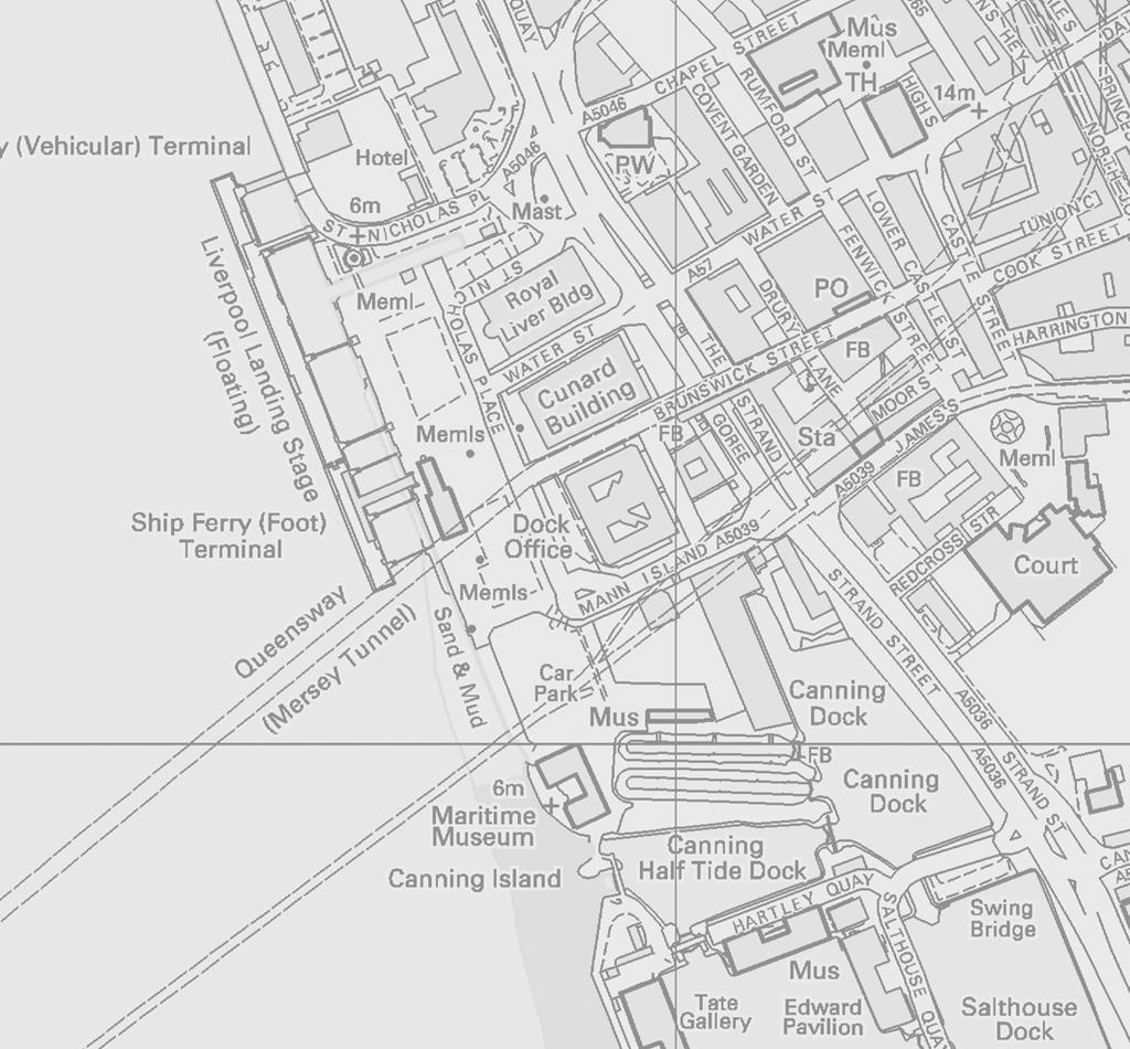

50

51


52 Mann Island Canal Link, Merseyside: Excavation Report PLATES Plate 1: Extract from Eyes map of 1765, east at the top Plate 2: Extract from Horwood s map of 1803, east at the top


53 Mann Island Canal Link, Merseyside: Excavation Report Plate 3: Sea wall 7304, from the west Plate 4: Embayment wall 7325, from the east

54 Mann Island Canal Link, Merseyside: Excavation Report Plate 5: Brick and stone bases 7339, from the south
Liverpool. Merseyside
 MANN ISLAND, Liverpool Merseyside Archaeological Excavation Report Oxford Archaeology North March 2012 Countryside Neptune llp Issue No: 2011-12/1243 OA North Job: L10312 NGR: SJ 3403 9008 Mann Island,
Test-Pit 3: 31 Park Street (SK )
") -Pit 3: 31 Park Street (SK 40732 03178) -Pit 3 was excavated in a flower bed in the rear garden of 31 Park Street, on the northern side of the street and west of an alleyway leading to St Peter s Church,
-Pit 3: 31 Park Street (SK 40732 03178) -Pit 3 was excavated in a flower bed in the rear garden of 31 Park Street, on the northern side of the street and west of an alleyway leading to St Peter s Church,
Greater London GREATER LONDON 3/606 (E ) TQ
 TQ") GREATER LONDON City of London 3/606 (E.01.6024) TQ 30358150 1 PLOUGH PLACE, CITY OF LONDON An Archaeological Watching Brief at 1 Plough Place, City of London, London EC4 Butler, J London : Pre-Construct
GREATER LONDON City of London 3/606 (E.01.6024) TQ 30358150 1 PLOUGH PLACE, CITY OF LONDON An Archaeological Watching Brief at 1 Plough Place, City of London, London EC4 Butler, J London : Pre-Construct
7. Prehistoric features and an early medieval enclosure at Coonagh West, Co. Limerick Kate Taylor
 7. Prehistoric features and an early medieval enclosure at Coonagh West, Co. Limerick Kate Taylor Illus. 1 Location of the site in Coonagh West, Co. Limerick (based on the Ordnance Survey Ireland map)
3. The new face of Bronze Age pottery Jacinta Kiely and Bruce Sutton
 3. The new face of Bronze Age pottery Jacinta Kiely and Bruce Sutton Illus. 1 Location map of Early Bronze Age site at Mitchelstown, Co. Cork (based on the Ordnance Survey Ireland map) A previously unknown
39, Walnut Tree Lane, Sudbury (SUY 073) Planning Application No. B/04/02019/FUL Archaeological Monitoring Report No. 2005/112 OASIS ID no.
 Planning Application No. B/04/02019/FUL Archaeological Monitoring Report No. 2005/112 OASIS ID no.") 39, Walnut Tree Lane, Sudbury (SUY 073) Planning Application No. B/04/02019/FUL Archaeological Monitoring Report No. 2005/112 OASIS ID no. 9273 Summary Sudbury, 39, Walnut Tree Lane, Sudbury (TL/869412;
39, Walnut Tree Lane, Sudbury (SUY 073) Planning Application No. B/04/02019/FUL Archaeological Monitoring Report No. 2005/112 OASIS ID no. 9273 Summary Sudbury, 39, Walnut Tree Lane, Sudbury (TL/869412;
New Composting Centre, Ashgrove Farm, Ardley, Oxfordshire
 New Composting Centre, Ashgrove Farm, Ardley, Oxfordshire An Archaeological Watching Brief For Agrivert Limited by Andrew Weale Thames Valley Archaeological Services Ltd Site Code AFA 09/20 August 2009
Church of St Peter and St Paul, Great Missenden, Buckinghamshire
 Church of St Peter and St Paul, Great Missenden, Buckinghamshire An Archaeological Watching Brief for the Parish of Great Missenden by Andrew Taylor Thames Valley Archaeological Services Ltd Site Code
Cetamura Results
 Cetamura 2000 2006 Results A major project during the years 2000-2006 was the excavation to bedrock of two large and deep units located on an escarpment between Zone I and Zone II (fig. 1 and fig. 2);
Archaeological. Monitoring & Recording Report. Fulbourn Primary School, Cambridgeshire. Archaeological Monitoring & Recording Report.
 Fulbourn Primary School, Cambridgeshire Archaeological Monitoring & Recording Report October 2014 Client: Cambridgeshire County Council OA East Report No: 1689 OASIS No: oxfordar3-192890 NGR: TL 5190 5613
An archaeological evaluation at 16 Seaview Road, Brightlingsea, Essex February 2004
 An archaeological evaluation at 16 Seaview Road, Brightlingsea, Essex February 2004 report prepared by Kate Orr on behalf of Highfield Homes NGR: TM 086 174 (c) CAT project ref.: 04/2b ECC HAMP group site
Limited Archaeological Testing at the Sands House Annapolis, Maryland
 Limited Archaeological Testing at the Sands House Annapolis, Maryland Report Submitted to Four Rivers Heritage Area by John E. Kille, Ph.D., Shawn Sharpe, and Al Luckenbach, Ph.D February 10, 2012 In May-June
Archaeological Watching Brief (Phase 2) at Court Lodge Farm, Aldington, near Ashford, Kent December 2011
 at Court Lodge Farm, Aldington, near Ashford, Kent December 2011") Archaeological Watching Brief (Phase 2) at Court Lodge Farm, Aldington, near Ashford, Kent December 2011 SWAT. Archaeology Swale and Thames Archaeological Survey Company School Farm Oast, Graveney Road
Archaeological Watching Brief (Phase 2) at Court Lodge Farm, Aldington, near Ashford, Kent December 2011 SWAT. Archaeology Swale and Thames Archaeological Survey Company School Farm Oast, Graveney Road
Former Whitbread Training Centre Site, Abbey Street, Faversham, Kent Interim Archaeological Report Phase 1 November 2009
 Former Whitbread Training Centre Site, Abbey Street, Faversham, Kent Interim Archaeological Report Phase 1 November 2009 SWAT. Archaeology Swale and Thames Archaeological Survey Company School Farm Oast,
Chapter 2. Remains. Fig.17 Map of Krang Kor site
 Chapter 2. Remains Section 1. Overview of the Survey Area The survey began in January 2010 by exploring the site of the burial rootings based on information of the rooted burials that was brought to the
Silwood Farm, Silwood Park, Cheapside Road, Ascot, Berkshire
 Silwood Farm, Silwood Park, Cheapside Road, Ascot, Berkshire An Archaeological Watching Brief For Imperial College London by Tim Dawson Thames Valley Archaeological Services Ltd Site Code SFA 09/10 April
Colchester Archaeological Trust Ltd. A Fieldwalking Survey at Birch, Colchester for ARC Southern Ltd
 Colchester Archaeological Trust Ltd A Fieldwalking Survey at Birch, Colchester for ARC Southern Ltd November 1997 CONTENTS page Summary... 1 Background... 1 Methods... 1 Retrieval Policy... 2 Conditions...
Fieldwalking at Cottam 1994 (COT94F)
") Fieldwalking at Cottam 1994 (COT94F) Tony Austin & Elizabeth Jelley (19 Jan 29) 1. Introduction During the winter of 1994 students from the Department of Archaeology at the University of York undertook
Fieldwalking at Cottam 1994 (COT94F) Tony Austin & Elizabeth Jelley (19 Jan 29) 1. Introduction During the winter of 1994 students from the Department of Archaeology at the University of York undertook
Monitoring Report No. 99
 Monitoring Report No. 99 Enniskillen Castle Co. Fermanagh AE/06/23 Cormac McSparron Site Specific Information Site Name: Townland: Enniskillen Castle Enniskillen SMR No: FER 211:039 Grid Ref: County: Excavation
ARCHAEOLOGICAL EVALUATION AT BRIGHTON POLYTECHNIC, NORTH FIELD SITE, VARLEY HALLS, COLDEAN LANE, BRIGHTON. by Ian Greig MA AIFA.
 ARCHAEOLOGICAL EVALUATION AT BRIGHTON POLYTECHNIC, NORTH FIELD SITE, VARLEY HALLS, COLDEAN LANE, BRIGHTON by Ian Greig MA AIFA May 1992 South Eastern Archaeological Services Field Archaeology Unit White
An archaeological evaluation at the Blackwater Hotel, Church Road, West Mersea, Colchester, Essex March 2003
 An archaeological evaluation at the Blackwater Hotel, Church Road, West Mersea, Colchester, Essex report prepared by Laura Pooley on behalf of Dolphin Developments (U.K) Ltd NGR: TM 0082 1259 CAT project
Fort Arbeia and the Roman Empire in Britain 2012 FIELD REPORT
 Fort Arbeia and the Roman Empire in Britain 2012 FIELD REPORT Background Information Lead PI: Paul Bidwell Report completed by: Paul Bidwell Period Covered by this report: 17 June to 25 August 2012 Date
An archaeological evaluation in the playground of Colchester Royal Grammar School, Lexden Road, Colchester, Essex
 An archaeological evaluation in the playground of Colchester Royal Grammar School, Lexden Road, Colchester, Essex February 2002 on behalf of Roff Marsh Partnership CAT project code: 02/2c Colchester Museum
2 Saxon Way, Old Windsor, Berkshire
 2 Saxon Way, Old Windsor, Berkshire An Archaeological Watching Brief For Mrs J. McGillicuddy by Pamela Jenkins Thames Valley Archaeological Services Ltd Site Code SWO 05/67 August 2005 Summary Site name:
An archaeological watching brief and recording at Brightlingsea Quarry, Moverons Lane, Brightlingsea, Essex October 2003
 An archaeological watching brief and recording at Brightlingsea Quarry, Moverons Lane, Brightlingsea, Essex commissioned by Mineral Services Ltd on behalf of Alresford Sand & Ballast Co Ltd report prepared
Grim s Ditch, Starveall Farm, Wootton, Woodstock, Oxfordshire
 Grim s Ditch, Starveall Farm, Wootton, Woodstock, Oxfordshire An Archaeological Recording Action For Empire Homes by Steve Ford Thames Valley Archaeological Services Ltd Site Code SFW06/118 November 2006
An archaeological evaluation at the Lexden Wood Golf Club (Westhouse Farm), Lexden, Colchester, Essex
, Lexden, Colchester, Essex") An archaeological evaluation at the Lexden Wood Golf Club (Westhouse Farm), Lexden, Colchester, Essex January 2000 Archive report on behalf of Lexden Wood Golf Club Colchester Archaeological Trust 12 Lexden
An archaeological evaluation at the Lexden Wood Golf Club (Westhouse Farm), Lexden, Colchester, Essex January 2000 Archive report on behalf of Lexden Wood Golf Club Colchester Archaeological Trust 12 Lexden
Evidence for the use of bronze mining tools in the Bronze Age copper mines on the Great Orme, Llandudno
 Evidence for the use of bronze mining tools in the Bronze Age copper mines on the Great Orme, Llandudno Background The possible use of bronze mining tools has been widely debated since the discovery of
Archaeological evaluation at the Onley Arms, The Street, Stisted, Essex
 Archaeological evaluation at the Onley Arms, The Street, Stisted, Essex November 2014 report by Pip Parmenter and Adam Wightman with a contribution from Stephen Benfield and illustrations by Emma Holloway
An archaeological watching brief at St Leonard s church, Hythe Hill, Colchester, Essex
 An archaeological watching brief at St Leonard s church, Hythe Hill, Colchester, Essex report prepared by Adam Wightman on behalf of Dorvell Construction CAT project ref.: 10/5d Colchester and Ipswich
An archaeological watching brief at Sheepen, Colchester, Essex November-December 2003
 An archaeological watching brief at Sheepen, Colchester, Essex November-December 2003 report prepared by Ben Holloway on behalf of Colchester Borough Council CAT project ref.: 03/11c Colchester Museums
Peace Hall, Sydney Town Hall Results of Archaeological Program (Interim Report)
") Results of Archaeological Program (Interim Report) Background The proposed excavation of a services basement in the western half of the Peace Hall led to the archaeological investigation of the space in
Results of Archaeological Program (Interim Report) Background The proposed excavation of a services basement in the western half of the Peace Hall led to the archaeological investigation of the space in
Suburban life in Roman Durnovaria
 Suburban life in Roman Durnovaria Additional specialist report Finds Ceramic building material By Kayt Brown Ceramic building material (CBM) Kayt Brown A total of 16420 fragments (926743g) of Roman ceramic
A Sense of Place Tor Enclosures
 A Sense of Place Tor Enclosures Tor enclosures were built around six thousand years ago (4000 BC) in the early part of the Neolithic period. They are large enclosures defined by stony banks sited on hilltops
Lanton Lithic Assessment
 Lanton Lithic Assessment Dr Clive Waddington ARS Ltd The section headings in the following assessment report refer to those in the Management of Archaeological Projects (HBMC 1991), Appendix 4. 1. FACTUAL
ARCHAEOLOGICAL MONITORING REPORT
 ARCHAEOLOGICAL MONITORING REPORT SCCAS REPORT No. 2009/324 Thorington Hall, Stoke by Nayland SBN 087 HER Information Date of Fieldwork: November 2009 - January 2010 Grid Reference: TM 0131 3546 Funding
1 The East Oxford Archaeology and History Project
 1 The East Oxford Archaeology and History Project EXOP TEST PIT 72 Location: Bartlemas Chapel, Cowley Date of excavation: 6-8 November 2013. Area of excavation: 0.8m x 1.2m, at the eastern end of the chapel.
STONE implements and pottery indicative of Late Neolithic settlement are known to
 Late Neolithic Site in the Extreme Northwest of the New Territories, Hong Kong Received 29 July 1966 T. N. CHIU* AND M. K. WOO** THE SITE STONE implements and pottery indicative of Late Neolithic settlement
ST PATRICK S CHAPEL, ST DAVIDS PEMBROKESHIRE 2015
 ST PATRICK S CHAPEL, ST DAVIDS PEMBROKESHIRE 2015 REPORT FOR THE NINEVEH CHARITABLE TRUST THE UNIVERSITY OF SHEFFIELD AND DYFED ARCHAEOLOGICAL TRUST Introduction ST PATRICK S CHAPEL, ST DAVIDS, PEMBROKESHIRE,
THE PRE-CONQUEST COFFINS FROM SWINEGATE AND 18 BACK SWINEGATE
 THE PRE-CONQUEST COFFINS FROM 12 18 SWINEGATE AND 18 BACK SWINEGATE An Insight Report By J.M. McComish York Archaeological Trust for Excavation and Research (2015) Contents 1. INTRODUCTION... 3 2. THE
SERIATION: Ordering Archaeological Evidence by Stylistic Differences
 SERIATION: Ordering Archaeological Evidence by Stylistic Differences Seriation During the early stages of archaeological research in a given region, archaeologists often encounter objects or assemblages
16 members of the Fieldwalking Group met York Community Archaeologist Jon Kenny at Lou Howard s farm, Rose Cottage Farm, at
 Terrington History Group Fieldwalking Group Field 1 Final report 21 October 2011 - fieldwalking 16 members of the Fieldwalking Group met York Community Archaeologist Jon Kenny at Lou Howard s farm, Rose
Control ID: Years of experience: Tools used to excavate the grave: Did the participant sieve the fill: Weather conditions: Time taken: Observations:
 Control ID: Control 001 Years of experience: No archaeological experience Tools used to excavate the grave: Trowel, hand shovel and shovel Did the participant sieve the fill: Yes Weather conditions: Flurries
Erection of wind turbine, Mains of Loanhead, Old Rayne, AB52 6SX
 Erection of wind turbine, Mains of Loanhead, Old Rayne, AB52 6SX Ltd 23 November 2011 Erection of wind turbine, Mains of Loanhead, Old Rayne, AB52 6SX CONTENTS 1 INTRODUCTION 3 2 ARCHAEOLOGICAL BACKGROUND
Higher National Unit Specification. General information for centres. Fashion: Commercial Design. Unit code: F18W 34
 Higher National Unit Specification General information for centres Unit title: Fashion: Commercial Design Unit code: F18W 34 Unit purpose: This Unit enables candidates to demonstrate a logical and creative
Cambridge Archaeology Field Group. Fieldwalking on the Childerley Estate, Cambridgeshire. Autumn 2014 to Spring Third interim report
 Cambridge Archaeology Field Group Fieldwalking on the Childerley Estate, Cambridgeshire Autumn 2014 to Spring 2015 Third interim report Summary Field walking on the Childerley estate of Martin Jenkins
Essex Historic Environment Record/ Essex Archaeology and History
 Essex Historic Environment Record/ Essex Archaeology and History CAT Report 578 Summary sheet Address: Kingswode Hoe School, Sussex Road, Colchester, Essex Parish: Colchester NGR: TL 9835 2528 Type of
NGSBA Excavation Reports
 ISSN 2221-9420 NGSBA Excavation Reports Volume 1 (2009) Salvage Excavation at Nahal Saif 2004 Final Report Excavation Permit: B - 293/2004 Excavating Archaeologist: Yehuda Govrin Y. G. Contract Archaeology
Greater London Region GREATER LONDON 3/567 (E.01.K099) TQ BERMONDSEY STREET AND GIFCO BUILDING AND CAR PARK
 TQ BERMONDSEY STREET AND GIFCO BUILDING AND CAR PARK") GREATER LONDON 3/567 (E.01.K099) TQ 33307955 156-170 BERMONDSEY STREET AND GIFCO BUILDING AND CAR PARK Assessment of an Archaeological Excavation at 156-170 Bermondsey Street and GIFCO Building and Car
GREATER LONDON 3/567 (E.01.K099) TQ 33307955 156-170 BERMONDSEY STREET AND GIFCO BUILDING AND CAR PARK Assessment of an Archaeological Excavation at 156-170 Bermondsey Street and GIFCO Building and Car
CONSERVATION OF THE RIEVALLEN STONE, CHURCH OF ST MARY S, RIEVAULX, NORTH YORKSHIRE
 CONSERVATION OF THE RIEVALLEN STONE, CHURCH OF ST MARY S, RIEVAULX, NORTH YORKSHIRE Nigel Copsey for Peter Pace, March 2007 St Mary s church, Rievaulx was originally a Gate Chapel for the Abbey below,
Moated Site at Manor Farm, Islip, Oxfordshire
 Moated Site at Manor Farm, Islip, Oxfordshire An Archaeological Excavation By Jo Pine Site Code MFI05 December 2007 Summary Site name: Moated Site at Manor Farm, Islip, Oxfordshire Grid reference: SP 5298
Excavations at Shikarpur, Gujarat
 Excavations at Shikarpur, Gujarat 2008-2009 The Department of Archaeology and Ancient History, the M. S. University of Baroda continued excavations at Shikarpur in the second field season in 2008-09. In
SALVAGE EXCAVATIONS AT OLD DOWN FARM, EAST MEON
 Proc. Hants. Field Club Archaeol. Soc. 36, 1980, 153-160. 153 SALVAGE EXCAVATIONS AT OLD DOWN FARM, EAST MEON By RICHARD WHINNEY AND GEORGE WALKER INTRODUCTION The site was discovered by chance in December
Tell Shiyukh Tahtani (North Syria)
") Tell Shiyukh Tahtani (North Syria) Report of the 2010 excavation season conducted by the University of Palermo Euphrates Expedition by Gioacchino Falsone and Paola Sconzo In the summer 2010 the University
Tell Shiyukh Tahtani (North Syria) Report of the 2010 excavation season conducted by the University of Palermo Euphrates Expedition by Gioacchino Falsone and Paola Sconzo In the summer 2010 the University
1 Introduction to the Collection
 Shahrokh Razmjou Center of Achaemenid Studies National Museum of Iran (Tehran) Project Report of the Persepolis Fortification Tablets in the National Museum of Iran 1 Introduction to the Collection During
TIPPERARY HISTORICAL JOURNAL 1994
 TPPERARY HSTORCAL JOURNAL 1994 County Tipperary Historical Society www.tipperarylibraries.ie/ths society@tipperarylibraries. ie SSN 0791-0655 Excavations at Cormac's Chapel, Cashel, 1992 and 1993: a preliminary
SAWANKHALOK GLOBULAR JARS: THE FIRST SIAMESE CELADON WARE TO REACH ENGLAND, AND OTHER NOTABLE PIECES
 r ' SAWANKHALOK GLOBULAR JARS: THE FIRST SIAMESE CELADON WARE TO REACH ENGLAND, AND OTHER NOTABLE PIECES The Sawankhalok kilns in the kingdom of Sukhothai, in northcentral Siam, produced large numbers
Museum of London Archaeological Archive: standards 2 Archive Components: Standards and Specifications 2.3 Finds
 Author Maloney, Cath. LAARC Version 3 Date 08/05/2013 Status Pre-publication Change History 2.9. Replacement of Registered Finds cards with image 2.3.4.3 2.8 Additions to Appendix: sample Finds Inventory
Bronze Age 2, BC
 Bronze Age 2,000-600 BC There may be continuity with the Neolithic period in the Early Bronze Age, with the harbour being used for seasonal grazing, and perhaps butchering and hide preparation. In the
Cambridge Archaeology Field Group. Fieldwalking on the Childerley Estate Cambridgeshire
 Cambridge Archaeology Field Group Fieldwalking on the Childerley Estate Cambridgeshire 2009 to 2014 Summary Fieldwalking on the Childerley estate of Martin Jenkins and Family has revealed, up to March
The lab Do not wash metal gently Never, ever, mix finds from different layers
 8 The lab 8.1 Finds processing The finds from the excavations at all parts of the site are brought down at the end of the day to the lab in the dig house. Emma Blake oversees the processing. Monte Polizzo
THE RAVENSTONE BEAKER
 DISCOVERY THE RAVENSTONE BEAKER K. J. FIELD The discovery of the Ravenstone Beaker (Plate Xa Fig. 1) was made by members of the Wolverton and District Archaeological Society engaged on a routine field
Chapel House Wood Landscape Project. Interim Report 2013
 Chapel House Wood Landscape Project Interim Report 2013 Chapel House Wood Landscape Project Interim Report 2013 The annual Dales Heritage Field School was held at Chapel House Wood again this year, and
YCCCART is very grateful to Richard Broomhead for permission to publish this report online.
 YCCCART 2017/Y2 Yatton & Congresbury Wildlife Action Group A Documentary & Archaeological Survey Of Two Moorland Sites In Yatton & Congresbury R.A.Broomhead BA Field Archaeologist RAB/15/9 YCCCART is very
Leeming to Barton Improvement
 Start of works exhibition March 2014 Welcome Introduction Following the public inquiry in November 2006, the Secretaries of State for Transport and Communities and Local Government announced the decision
ARCHAEOLOGICAL S E R V I C E S. St Nicholas' Church, Barrack Hill, Nether Winchendon, Buckinghamshire. Archaeological Watching Brief.
 T H A M E S V A L L E Y ARCHAEOLOGICAL S E R V I C E S St Nicholas' Church, Barrack Hill, Nether Winchendon, Buckinghamshire Archaeological Watching Brief by Steven Crabb Site Code: STW17/229 (SP 7735
BUTE MAP 8: ST NINIAN S POINT to ETTRICK BAY
 BUTE MAP 8: ST NINIAN S POINT to ETTRICK BAY Hinterland Geology and Coastal Geomorphology: The stretch of coastline between Rubha An Amair and Island McNeil sees Dunoon Phylites emerge towards the north
Monitoring Report No Sacred Heart Church Aghamore Boho Co. Fermanagh AE/10/116E. Brian Sloan L/2009/1262/F
 Monitoring Report No. 202 Sacred Heart Church Aghamore Boho Co. Fermanagh AE/10/116E Brian Sloan L/2009/1262/F Site Specific Information Site Address: Sacred Heart Church, Aghamore, Boho, Co. Fermanagh
Barnet Battlefield Survey
 In terim report on the progress of the Barnet Battlefield Survey December 2016 The Barnet Battlefield Survey is an archaeological investigation into the 1471 Battle of Barnet. It aims to define more accurately
Hair colour correction services
 Hair colour correction services The aim of this unit is to develop your knowledge, understanding and the skills necessary to determine and correct more complex colouring problems. To achieve this unit,
1. Presumed Location of French Soundings Looking NW from the banks of the river.
 SG02? SGS SG01? SG4 1. Presumed Location of French Soundings Looking NW from the banks of the river. The presumed location of SG02 corresponds to a hump known locally as the Sheikh's tomb. Note also (1)
An archaeological evaluation by trial-trenching at Scotts Farm, Lodge Lane, Purleigh, Essex October 2011
 An archaeological evaluation by trial-trenching at Scotts Farm, Lodge Lane, Purleigh, Essex October 2011 report prepared by Adam Wightman on behalf of Richard Emans CAT project ref.: 11/10a NGR: TL 582719
Burrell Orchard 2014: Cleveland Archaeological Society Internship Amanda Ponomarenko The Ohio State University June - August 2014
 1 Burrell Orchard 2014: Cleveland Archaeological Society Internship Amanda Ponomarenko The Ohio State University June - August 2014 Selected for the 2014 Cleveland Archaeological Society Internship in
An archaeological watching brief on one section of an Anglian Water main Spring Lane, Lexden, Colchester
 An archaeological watching brief on one section of an Anglian Water main Spring Lane, Lexden, Colchester April-September 2001 on behalf of Breheny Contractors CAT project ref.: 01/4D Colchester Museum
TOTTENHAM COURT ROAD CROSSRAIL EASTERN TICKET HALL 12 Goslett Yard London WC2
 TOTTENHAM COURT ROAD CROSSRAIL EASTERN TICKET HALL 12 Goslett Yard London WC2 City of Westminster A targeted watching brief report November 2010 Museum of London 2010 Site code: TCG 09 NGR: 529810 181260
NORTH PENNINES ARCHAEOLOGY LTD
 NORTH PENNINES ARCHAEOLOGY LTD Client Report No. CP/446/07 Planning Reference: 2060799 NCCCT Reference: T13/23; 5982 OASIS Reference: northpen3-25609 Tony Liddell B.Sc. Nenthead Mines Heritage Centre Nenthead
HERITAGE VAUGHAN REPORT
 Item: 3 HERITAGE VAUGHAN REPORT DATE: Wednesday, June 20, 2018 WARD(S): 2 TITLE: NEW CONSTRUCTION DETACHED GARAGE 8006 KIPLING AVENUE, WOODBRIDGE HERITAGE CONSERVATION DISTRICT FROM: Jason Schmidt-Shoukri,
WESTSIDE CHURCH (TUQUOY)
") Property in Care (PIC) ID: PIC324 Designations: Scheduled Monument (SM90312) Taken into State care: 1933 (Guardianship) Last reviewed: 2004 HISTORIC ENVIRONMENT SCOTLAND STATEMENT OF SIGNIFICANCE WESTSIDE
Property in Care (PIC) ID: PIC324 Designations: Scheduled Monument (SM90312) Taken into State care: 1933 (Guardianship) Last reviewed: 2004 HISTORIC ENVIRONMENT SCOTLAND STATEMENT OF SIGNIFICANCE WESTSIDE
Grange Farm, Widmer End, Hughenden, Buckinghamshire
 Grange Farm, Widmer End, Hughenden, Buckinghamshire An Archaeological Evaluation for British Flora by Andy Taylor Thames Valley Archaeological Services Ltd Site Code GFH 05/63 July 2005 Summary Site name:
STONES OF STENNESS HISTORIC ENVIRONMENT SCOTLAND STATEMENT OF SIGNIFICANCE
 Property in Care (PIC) ID: PIC321 Designations: Scheduled Monument (SM90285); Taken into State care: 1906 (Guardianship) Last reviewed: 2003 HISTORIC ENVIRONMENT SCOTLAND STATEMENT OF SIGNIFICANCE STONES
Small Finds Assessment, Minchery Paddock, Littlemore, Oxford (MP12)
") Small s Assessment, Minchery Paddock, Littlemore, Oxford (MP12) Introduction A total of 51 objects recovered from excavations at Minchery Paddock, Littlemore, Oxford (MP12) were submitted for dating and
Small s Assessment, Minchery Paddock, Littlemore, Oxford (MP12) Introduction A total of 51 objects recovered from excavations at Minchery Paddock, Littlemore, Oxford (MP12) were submitted for dating and
A visit to the Wor Barrow 21 st November 2015
 A visit to the Wor Barrow 21 st November 2015 Following our exploration of Winkelbury a few weeks previously, we fast forwarded 12 years in Pitt Rivers remarkable series of excavations and followed him
Decorative Styles. Amanda Talaski.
 Decorative Styles Amanda Talaski atalaski@umich.edu Both of these vessels are featured, or about to be featured, at the Kelsey Museum. The first vessel is the third object featured in the Jackier Collection.
12 October 14, 2015 Public Hearing
 12 October 14, 2015 Public Hearing APPLICANT: SECOND SHOT, LLC PROPERTY OWNER: ALBERT VINCIGUERRA STAFF PLANNER: Kevin Kemp REQUEST: Conditional Use Permit (Tattoo Parlor) ADDRESS / DESCRIPTION: 5759 Princess
Archaeological Material From Spa Ghyll Farm, Aldfield
 Archaeological Material From Spa Ghyll Farm, Aldfield Introduction Following discussions with Linda Smith the Rural Archaeologist for North Yorkshire County Council, Robert Morgan of 3D Archaeological
REACH AND ITS IMPACT ON COSMETICS
 September 2008 REACH AND ITS IMPACT ON COSMETICS In June 2007, the European Union s Regulation (EC) No. 1907/2006 on the Registration, Evaluation, Authorization, and Restriction of Chemicals (the REACH
FURTHER MIDDLE SAXON EVIDENCE AT COOK STREET, SOUTHAMPTON (SOU 567)
") Roc. Hampshire Field Club Archaeol. Soc 52,1997, 77-87 (Hampshire Studies 1997) FURTHER MIDDLE SAXON EVIDENCE AT COOK STREET, SOUTHAMPTON (SOU 567) By M F GARNER andj VINCENT with a contribution byjacqueline
Roc. Hampshire Field Club Archaeol. Soc 52,1997, 77-87 (Hampshire Studies 1997) FURTHER MIDDLE SAXON EVIDENCE AT COOK STREET, SOUTHAMPTON (SOU 567) By M F GARNER andj VINCENT with a contribution byjacqueline
Phase 2 Urban consolidation AD
 Phase 2 Urban consolidation AD 1250-1350 The second recognised phase of activity at Rådhuspladsen corresponded approximately to the High medieval period (c. AD 1250 1350), and saw consolidation of the
NW Bicester Masterplan. Access and Travel Strategy Appendix 7 Traffic Impact
 NW Bicester Masterplan Access and Travel Strategy Appendix 7 Traffic Impact Hyder Consulting (UK) Limited 2212959 HCL House Fortran Road St Mellons Business Park St Mellons Cardiff CF3 0EY United Kingdom
ROMAN AND MEDIEVAL ACTIVITY IN THE UPPER WALBROOK VALLEY: EXCAVATIONS AT MOORGATE, CITY OF LONDON, EC2, 1997
 ROMAN AND MEDIEVAL ACTIVITY IN THE UPPER WALBROOK VALLEY: EXCAVATIONS AT 12 18 MOORGATE, CITY OF LONDON, EC2, 1997 Graham Bruce, Dominic Perring, Tim Stevens and Melissa Melikian SUMMARY In January and
IRAN. Bowl Northern Iran, Ismailabad Chalcolithic, mid-5th millennium B.C. Pottery (65.1) Published: Handbook, no. 10
 Published: Handbook, no. 10") Bowl Northern Iran, Ismailabad Chalcolithic, mid-5th millennium B.C. Pottery (65.1) IRAN Published: Handbook, no. 10 Bowl Iran, Tepe Giyan 2500-2000 B.C. Pottery (70.39) Pottery, which appeared in Iran
Bowl Northern Iran, Ismailabad Chalcolithic, mid-5th millennium B.C. Pottery (65.1) IRAN Published: Handbook, no. 10 Bowl Iran, Tepe Giyan 2500-2000 B.C. Pottery (70.39) Pottery, which appeared in Iran
BALNUARAN. of C LAVA. a prehistoric cemetery. A Visitors Guide to
 A Visitors Guide to BALNUARAN of C LAVA a prehistoric cemetery Milton of Clava Chapel (?) Cairn River Nairn Balnuaran of Clava is the site of an exceptionally wellpreserved group of prehistoric burial
Oxfordshire. Wallingford. St Mary-le-More. Archaeological Watching Brief Report. Client: JBKS Architects and St Mary s Renewal Campaign.
 St Mary-le-More Wallingford Oxfordshire Archaeological Watching Brief Report February 2010 Client: JBKS Architects and St Mary s Renewal Campaign Issue No:1 OA Job No: 4432 NGR: SU 6071 8933 Archaeological
Land North of Pesthouse Lane Barham Suffolk BRH 054
 Land North of Pesthouse Lane Barham Suffolk BRH 054 Archaeological Evaluation Report SCCAS Report No. 2012/142 Client: Barham Parish Council Author: Jezz Meredith September 2012 SCCAS Land North of Pesthouse
PIGEON COVE, LABRADOR Lisa Rankin Memorial University of Newfoundland
 PIGEON COVE, LABRADOR Lisa Rankin Memorial University of Newfoundland I n 2012, I conducted excavations at an historic period Inuit site (FlBf-6) in Pigeon Cove, on Newfoundland Island near Cartwright,
SAC S RESPONSE TO THE OECD ALIGNMENT ASSESSMENT
 SAC S RESPONSE TO THE OECD ALIGNMENT ASSESSMENT A Collaboration Between the Sustainable Apparel Coalition and the Organisation for Economic Cooperation and Development February 13, 2019 A Global Language
Community Services Committee 14 December Report for Decision. The Eden Hore Collection Building from the Feasibility Study (COM )
") Community Services Committee 14 December 2016 Report for Decision The Eden Hore Collection Building from the Feasibility Study (COM 05 01 008) Purpose of Report To present the feasibility study report
Community Services Committee 14 December 2016 Report for Decision The Eden Hore Collection Building from the Feasibility Study (COM 05 01 008) Purpose of Report To present the feasibility study report
MODAPTS. Modular. Arrangement of. Predetermined. Time Standards. International MODAPTS Association
 MODAPTS Modular Arrangement of Predetermined Time Standards International MODAPTS Association ISBN-72956-220-9 Copyright 2000 International MODAPTS Association, Inc. Southern Shores, NC All rights reserved.
How Signet Leads: Driving Integrity in the Global Jewelry Supply Chain By Virginia C. Drosos, Chief Executive Officer, Signet Jewelers
 How Signet Leads: Driving Integrity in the Global Jewelry Supply Chain By Virginia C. Drosos, Chief Executive Officer, Signet Jewelers Jewelry, for me, like many customers, is all about a meaningful moment,
A Summer of Surprises: Gezer Water System Excavation Uncovers Possible New Date. Fig. 1, Gezer Water System
 Can You Dig It A Summer of Surprises: Gezer Water System Excavation Uncovers Possible New Date Posted: 14 Sep 2016 07:29 AM PDT By Dan Warner and Eli Yannai, Co-Directors of the Gezer Water System Excavations