Archaeology. at Bloomberg
|
|
|
- Mark Baldwin
- 6 years ago
- Views:
Transcription
1 Archaeology at Bloomberg
2 Published in 2017 by MOLA MOLA All rights reserved. No part of this publication may be reproduced, stored in a retrieval system or transmitted, in any form or by any means, electronic, mechanical, photocopying, recording or otherwise, without prior permission of the copyright owner. Text: MOLA Principal contributors: Jessica Bryan, Rachel S Cubitt, Julian Hill, Nick Holder, Sophie Jackson, Sadie Watson Editor: Susan M Wright Copy editing: Wendy Sherlock Illustrations: Hannah Faux, Juan José Fuldain; artist s reconstructions Judith Dobie Photography: Andy Chopping, Maggie Cox Design: Pentagram Design and layout: Sue Cawood, Tracy Wellman Production: Tracy Wellman
3 Foreword by Michael R Bloomberg 1 Introduction 5 Bloomberg through time: c AD 48 to c AD The Romans arrive 14 The Boudican revolt, AD 60/1 20 London expands, AD 62 to c AD 140 a town of merchants and traders 28 Building development in the Walbrook valley, AD 62 to c AD Later Roman London, c AD 140 to c AD Bloomberg through time: c AD 410 to the mid 17th century 46 A diverse medieval city 50 Walbrook: stream, street and district 54 Merchants and humanists: the Bukerels, Thomas More and the Barge Contents

4 Bloomberg archaeology Excavation in progress at the Bloomberg site in 2012, looking north, with 1 Poultry to the left and St Stephen Walbrook church to the right of the site
5 61 Bloomberg through time: 1666 to c The Great Fire of London and reconstruction 68 The City of London from the 17th to early 20th century 74 The Bloomberg site in c Mithras refound: 20th to 21st century 82 The discovery of the mithraeum 94 The mystery of Mithras 100 The Walbrook mithraeum 108 The new reconstruction 114 London Mithraeum Bloomberg SPACE 119 Notes

6 Respecting the storied past The two interconnected volumes that comprise the Bloomberg building are separated by a covered pedestrian arcade, a reinstated portion of the Roman and medieval and later road that once crossed the site Watling Street and Budge Row
7 Our new European headquarters is right at the heart of the City of London. A symbol of Bloomberg s commitment to London and its future, it also preserves and celebrates the past. The building, by Foster + Partners, occupies one of the UK s most important archaeological sites, famous since the 1950s as the site of a temple to the Roman god Mithras. The archaeological investigations that took place in as part of the building s construction have made the site nationally and internationally important for a second time. The astonishing quantity, range and preservation of the objects recovered from the site make this the most significant archaeological project undertaken in London in recent decades. As steward of this ancient site and artefacts, Bloomberg has embraced the City of London s rich heritage. And as a company that is centred on communication of data, information, news, and analysis we are thrilled that Bloomberg has been at the core of a project that has provided so much, hugely important, new information about the character and development of Roman London during its first century of existence. Foreword by Michael R Bloomberg

8 Timber fence c AD 85 The oak horizontal base boards and vertical planking survived remarkably well in the damp ground at the Bloomberg site
9 London has been an internationally important trading, industrial and financial centre since at least the 17th century, but its history stretches back nearly 2000 years to its foundation shortly after the Roman conquest of Britain in AD 43. It is located on the lower, tidal reaches of the largest river of south-east Britain, the Thames, which flows into the North Sea. The Bloomberg site lies on the north bank, in the Walbrook valley, in the centre of the Roman town and the medieval and later city. The site contained one of the most evocative Roman remains ever found in Britain the Walbrook temple to the god Mithras. Its identification in 1954 led to intense public interest in the cult of Mithras. The temple ruins were rebuilt in the 1960s, 100m from their original site. Now, the Bloomberg building has enabled the remains to be newly reconstructed, more accurately and close to the original location of the temple the London Mithraeum. The Bloomberg site was the most extensive and significant excavation of Roman levels in the modern City of London for 20 years. Why is this site so important? This low-lying zone was rapidly filled in to raise the ground level and create usable land. In consequence, the site contained a great depth of Roman layers and many, successive, well-preserved timber buildings. The excavated finds assemblage is unrivalled in Roman London, in quantity and range, and includes objects of great intrinsic importance. The Walbrook stream and natural drainage patterns have kept the ground damp from the Roman period onwards, resulting in exceptional survival of artefacts. The full range of Roman material culture is present, including wooden and leather items. The wooden writing tablets are one example of this: although commonplace in the Roman world, this type of object rarely survives; the 400+ from the Bloomberg site more than doubles the total previously found in London. Study of the Bloomberg artefacts has already contributed enormously to our understanding of both the site and the wider Roman town in its first 100 years, and they will continue to play an important role in future research. Introduction
10 City of London Moorga Street Roman town wall, built c AD 200 Thames 0 500m Lo Cheapside Queen Street Bucklersbury Poultry Bank Archaeology focuses on recording evidence that will be affected by redevelopment. Only those parts of the Bloomberg site where the new building s foundations exceeded the depth of the pre-existing ones were excavated. Consequently, most of the archaeological information recovered during the main excavation in relates to the northeast corner of the site. the site Mansion House Queen Victoria Street Queen Street Cloak Lane Dowgate Hill Walbrook Cannon Street Cannon Street Upper Thames Street 0 100m River Thames horizontal archaeological survival in the excavated areas up to 7m depth up to 2m depth up to 1m depth recorded in section only no survival Bloomberg The site s location in the modern City of London, archaeological survival in the areas of excavation before work began (scale upper 1:50,000, lower 1:4000)

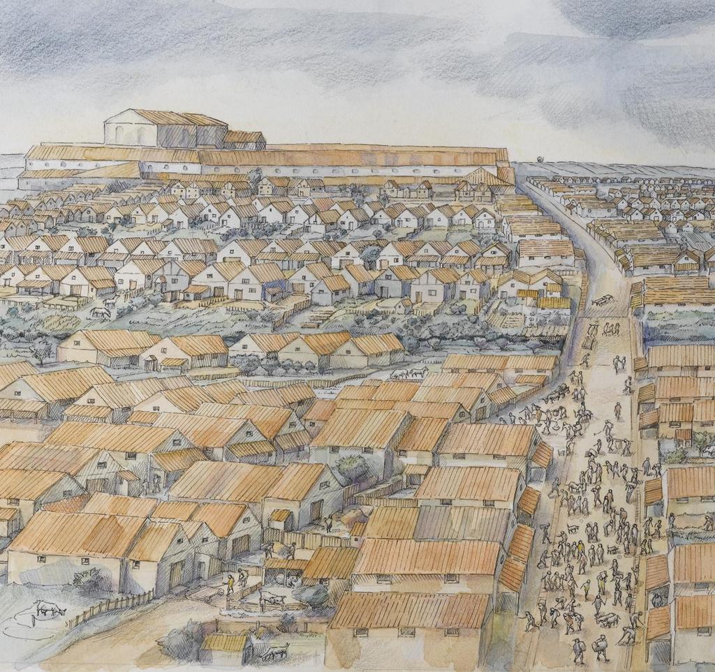
11 North-east corner Looking south across the north-east corner of the site in 2012 as excavation takes place in advance of the construction of the Bloomberg building and an access to Bank underground station beneath it 3 Introduction
12
13 Bloomberg through time c AD 48 to c AD 410
14 Bloomberg through time: c AD 48 to c AD 410 The Romans arrive Expanding their empire, the Romans invade Britain in AD 43 and within five years establish a settlement known as Londinium ; this rapidly becomes a busy port and crossing point on the Thames. The boundaries of Londinium, which was fortified c AD 200, correspond roughly with the limits of the City of London today.

15 The Roman conquest of AD 43 brought an island on the north-western fringe of the continent of Europe into direct contact with the far wealthier, cosmopolitan world of the Mediterranean. Before the Romans settled here, the modern City of London and north Southwark which correspond fairly closely in extent to the area that became the Roman town lay within a landscape dominated by the Thames and sparsely populated by a people who spoke a Celtic language ancestral to modern Welsh. The Bloomberg site was in a wooded valley, through which the Walbrook stream flowed south to the Thames. The Walbrook valley before the Romans Artist s reconstruction of the pre-roman wooded landscape of the area now occupied by the City of London, looking north-west across the Thames from what today is Southwark; the mouth of the Walbrook stream is centre left, the Fleet river top left Geoarchaeology (the study of borehole and other data to reconstruct past landscapes) allows us to reconstruct the topography of pre-roman London in some detail. The River Thames was far broader than it is today (the narrowing is the result of centuries of reclamation) and the incoming tide spread out over a far greater area, meaning that high tide levels (and tidal range) were much lower. To the east, marshes fringed both banks of the Thames and would have flooded at high tide. But, in the area of what was to become the Roman town, the marshes of the north bank gave way to two low gravel hills; these were divided by a small stream, the Walbrook (this joined the Thames under what is now Upper Thames Street). On the opposite bank (in what is now Southwark) lay some dry gravel islands. 7 The Romans arrive
16 Timeline AD 43 Roman invasion of Britain Fleet W alb ro ok Neolithic axe head This prehistoric stone axe head, modified to be worn as a pendant, was found in Roman levels at the Bloomberg site (length 69mm) marketplace the site Rive r Th (mod ames ern) 0 London c AD 60 (scale 1:20,000) 500m roads: known and conjectured conjectured built-up area high tide low tide
17 Julius Caesar had led brief military expeditions to Britain in 55 and 54 BC as part of his campaign to conquer Gaul (modern-day France): the first was disrupted by bad weather and barely advanced further than its beachhead; the second lasted over a month and involved military operations as far north as the Thames, before withdrawing. Caesar s description of his expedition (in De Bello Gallico) means that much more is known about Britain at that time than for earlier periods. The River Thames acted as a boundary between tribal groupings, particularly in the estuary. London was not a centre of power or population, although a scatter of farmsteads or small settlements would have lain within what is now the Greater London area. Very little pre-roman material is encountered on archaeological excavations in central London and there is no evidence for a pre-roman settlement of any size. The tribal capitals lay away from the river within their respective hinterlands. Objects of great antiquity are occasionally found in London stone tools and Neolithic, Bronze Age and Iron Age pottery. And it seems that Roman settlers came across these chance items as well. A Neolithic axe head, present in the Roman levels at the Bloomberg site, had been modified (the grooves and hole at the thin end are there to secure a metal mount) so that it could be worn as a pendant. The invasion force that landed in Kent in AD 43 probably consisted of four legions, which with auxiliaries would represent nearly 40,000 men (joined later by camp followers, including women). The first objectives were the tribal capitals in south-east Britain and, once the Cantii in Kent (and their capital at Canterbury) were under Roman occupation, the army moved on to Colchester, the capital of the Trinovantes who controlled Essex and south Suffolk. Although Roman control was imposed primarily through military strength, some British tribes, such as the Iceni in Norfolk, seem to have come to terms with the new world order and retained a quasiindependent status as client kingdoms or civitates. The Roman expectation was that the tribal aristocracy would over time conform to the model of the Roman official classes elsewhere in the empire, serving in the legions and acting as local administrators. Roman towns, usually founded at the sites of existing centres of tribal power, played an important role, acting as hubs of Roman influence. London was a new creation and so an exception to this pattern. Tree-ring dating indicates London was very probably founded about AD 48. Within 13 years it had become the most important place in Roman Britain and its capital. A number of factors account for its success. Firstly, London was the most seaward point at which the Thames and its flanking marshland could be relatively easily bridged and this crossing offered the most direct route for a road connecting Richborough (Rutupiae), the original Roman Channel port in Kent, to Colchester (Camulodunum). A permanent bridge over the Thames could have been in place by c AD 52 if not earlier. London bridge has remained important for almost all the succeeding two millennia and the modern bridge alignment deviates from that of the Roman one by less than 100m. Colchester was the original choice for the Roman provincial capital, but as more of Britain came under Roman control, London s advantages became more evident. It was a port, close to the tidal head of the Thames, and could act as a distribution centre controlling the largest river valley in southeast Britain. The Roman invasion both created London and made it into a strategically important place. But, as a new foundation, London s development was probably driven as much by economic as political considerations. What was the composition of London s population in its first decade? Archaeological evidence demonstrates that the settlement was expanding very quickly in the years immediately before the Boudican revolt of AD 60/1 and Tacitus described it as very full of businessmen and commerce (Londinium copia negotiatorum et commeatuum maxime celebre) (Tacitus, Annales 14.33). 9 The Romans arrive

18 road The site c AD 60 Banks and ditches, gullies and drains (scale 1:750) Walbrook stream bridge wattle-lined drain gully c 2.0m OD c 5.0m OD access via ramp pits c 2.6m OD enclosure banks Enclosure bank Section through one of the early earthen banks dating to the AD 50s (0.5m scale); finds from the material brought on to the site to construct the banks included the stylus writing tablet carrying the date AD 57 (facing page) timber revetments road bridge constructed AD 61 timber piles Walbrook inlet 0 25m

19 There would also have been some military presence. And as with any town, there were shops and taverns to service the inhabitants. The main east west road through Roman London ran immediately north of the Bloomberg site and bridged the Walbrook stream at a point that would now be more or less directly outside the Bloomberg building s entrance on Bucklersbury (although the level of the Roman road was some 6 7m (19½ 23 feet) below that of the modern pavement). By c AD 60, a suburb was developing alongside this road, west of the Walbrook stream. A second Roman road was extended westwards to bridge the Walbrook in the southern part of the site. Tree-ring dates from the bridge foundations confirm it was built between AD 48 and AD 61. Despite being close to these roads, the Bloomberg site itself was not built upon before AD 60/1 because it was low-lying ground, next to the stream. It was not completely unused: banks and ditches subdivided it and some metalworking seems to have taken place here. A total of 12 wooden writing tablets were recovered from these earliest levels of the site, dated c AD 48 60/1. They include a stylus tablet that carries a written date equivalent to 8 January AD 57. This, the earliest internally dated correspondence from Roman Britain, is an object of enormous significance in its own right. AD 57 writing tablet Stylus writing tablet dated 8 January AD 57, wherein Tibullus, the freedman of Venustus, writes that he owes Gratus, the freedman of Spurius, 105 denarii from the price of the merchandise which has been sold and delivered (width 137mm) 11 The Romans arrive

20 Roman Londoners Londinium was a new town founded by incomers to Britain. The early artefacts seem to reflect an immigrant population, including probably some of the soldiers involved in the invasion, as well as an influx of traders and craftsmen eager to take advantage of new economic opportunities. Many are likely to have come from Gaul (modern-day France) and would have been keen to reproduce a way of living similar to that found in Roman urban centres across the Channel; their dress, diet and domestic arrangements were closer to those found in Gaul than those of the native population who lived in the surrounding British countryside. Within a few decades, however, it is likely that Londinium had developed a more mixed population with its own distinctive character, one reflected in the objects in local Romano-British styles that circulated alongside imports. Above Excellent organic preservation led to the recovery of leather footwear, such as this intricate one-piece carbatina shoe (length 235mm)
 and Romano-British (right) styles (left, length 36.")
 Above Iron signet ring set with chalcedony intaglio: the engraving shows an eagle devouring a hare;")
,")
 Far right Glass unguent flask that may have contained")
21 Top, left and centre Ornate copper-alloy plate brooches illustrate some distinctive, regional, fashion traditions compare these Continental (left) and Romano-British (right) styles (left, length 36.7mm; right, length 37.9mm) Above Iron signet ring set with chalcedony intaglio: the engraving shows an eagle devouring a hare; signet rings could be impressed in wax to seal documents (gemstone, max length 12mm) Right Copper-alloy toilet sets are found across the Roman world, but the inclusion of nail-cleaners (with bifurcated tip), alongside the tweezers and ear scoop, is a more distinctively Romano-British feature, suggesting regional differences in grooming (tweezers, length 53mm) Far right Glass unguent flask that may have contained cosmetics, perfumes or oils used in Roman styles of grooming and bathing (length 125mm) 13 The Romans arrive
22 Bloomberg through time: c AD 48 to c AD 410 The Boudican revolt, AD 60/1 The Romans brutally impose direct rule on the tribal aristocracy, who revolt; led by Boudica, queen of the Iceni, the rebels sack and burn London. Later Roman writers graphically describe the destruction, and the event is visible in archaeological levels across London.

 at Colchester had also led to land confiscations.")
23 In AD 60/1 the king of the Iceni, Prasutagus, died, leaving his East Anglian kingdom to his daughters with the emperor (Nero) as co-heir, hoping through this arrangement to maintain its semi-independent status. In fact, this was taken as a cue by the provincial government to impose direct Roman administration and treat the Iceni as a conquered people. The lands of the tribal aristocracy were confiscated and, according to Tacitus, Prasutagus widow Boudica was whipped and her daughters raped. The Iceni rose in revolt, joined by the Trinovantes of Essex, where the creation of the colonia (town of army veterans) at Colchester had also led to land confiscations. The principal historical source for the Boudican revolt is Tacitus, who wrote about 50 years after the event and dated it to the year AD 61, although many modern historians believe it occurred the previous year (hence AD 60/1 in this book). Because most of the Roman army had moved away from south-east Britain considered pacified by AD 60 the Boudican revolt initially met little resistance, and when it did the British annihilated a detachment of the legio IX Hispana (ninth Spanish legion) sent to intercept them. Boudica was finally defeated by a Roman force at a battle at an unknown location, probably somewhere in the English Midlands. Shortly after, according to the classical sources, she either committed suicide (Tacitus) or died of illness (Cassius Dio). Her age is unknown. The consequences for London were catastrophic. As the Roman army was engaged in extending Roman control further north and west, the rebels were able to sack three important but poorly defended towns: Colchester, St Albans (Verulamium) and London itself. London was effectively destroyed. The event survives in the archaeological record as a layer of red, burnt debris, the scorched remains of a town built almost entirely of wood and daub (clay). At the Bloomberg site, which was not yet occupied by buildings in AD 60/1, the characteristic fire debris was absent, but archaeological sites nearby show there were intense fires less than 40m away. Tacitus (Annales 14.33) records that 70,000 Roman citizens and allies (civium et sociorum) died in St Albans and London, although the accuracy or otherwise of this figure can only be guessed at. After a brief period of disarray, the Roman military regrouped and emphatically suppressed the revolt. British coin A 1st-century AD native British coin found at the Bloomberg site: this silver coin was minted in East Anglia, the region that rose up in the Boudican revolt of AD 60/1, and has subsequently been pierced through, perhaps to be worn as a pendant or similar; is this a Roman trophy celebrating the suppression of the revolt? (diameter 14mm) 15 The Boudican revolt, AD 60/1
 by Thomas Thornycroft standing near Westminster")
24 Timeline AD 60/1 Boudican revolt, London burns Boudica Statue of Boudica (Boudicea) by Thomas Thornycroft standing near Westminster Pier, London
 Very little is known about Boudica and it is difficult to disentangle a real person from the romantic myths that have accrued to her ever since her death.")
25 Destruction The walls of a shop about 50m from the Bloomberg site destroyed in AD 60/1; the keying for the wall plaster (which fell off in the blaze) has been fired orange-red by the heat (0.5m scale) Very little is known about Boudica and it is difficult to disentangle a real person from the romantic myths that have accrued to her ever since her death. Roman writers were as prone to this as more modern authors. In the early 3rd century AD, for example, Cassius Dio wrote: In stature she was very tall, in appearance most terrifying, in the glance of her eye most fierce, and her voice was harsh; a great mass of the tawniest hair fell to her hips; around her neck was a large golden necklace; and she wore a tunic of divers colours over which a thick mantle was fastened with a brooch. (Dio s Roman History, VIII, translated E Cary, 2001 edition, p 85) 17 The Boudican revolt, AD 60/1

26 The Roman army The foundation of London may have been a military decision. Alternatively, it may have grown as traders and merchants mostly from other provinces in the north-western Roman empire decided to base themselves there. Probably both factors played a role. Finds from the Bloomberg site indicate that soldiers were present in the settlement from the very beginning perhaps there was a small garrison to guard the Thames river crossing but the majority of the military objects come from the period after the Boudican revolt in AD 60/1. The army played an important part in the rebuilding of Londinium and in its developing role as a centre for government. Soldiers, bearing arms and wearing distinctive military uniforms, would have been a highly visible component of the population. For those who had decided to settle in London for economic reasons, an influx of troops could have represented a return to security and stability; for any native elements in the area, soldiers would have been a potent symbol of conquest and the Roman oppression that had sparked the revolt in the first place. Right Ceramic lamp with stag decoration: in Roman Britain lamps, burning imported olive oil, seem to be most commonly found on sites where the army was present and would have allowed the administrative duties of soldiers to continue into the evening, as well as illuminating other activities (length 81mm)


 Above Some soldiers wore chain mail while others wore plate")
")
")

27 Top left Serving in the army was inherently dangerous and bone amulets, such as this one, showing a phallus and a fist making the fig sign representing female genitalia, are common finds on military sites; their symbolism was believed to ward off the evil eye (length 83.4mm) Above Some soldiers wore chain mail while others wore plate and scale armour; this hinged copper-alloy fitting comes from the shoulder of a lorica segmentata plate armour cuirass (length 60mm) Bottom left A diverse range of fighting styles are represented by the range of weapons from the site; these include (left to right) iron spearheads, an iron arrowhead with a slot for attaching a burning rag and a lead slingshot (left to right, length 171mm, 110.8mm, 91mm (bent tip), 36.2mm ) 19 The Boudican revolt, AD 60/1
28 Bloomberg through time: c AD 48 to c AD 410 London expands, AD 62 to c AD 140 a town of merchants and traders Londinium recovers more soldiers arrive in Britain, a temporary fort is built in London, merchants return and life goes on; the town is rebuilt and London, now the capital, booms as the emperor invests in the province.
29 Pretty much destroyed by Boudica s forces, it took maybe as much as a decade for Londinium to get back to where it had been. But life went on nonetheless. An important stylus writing tablet, recovered from a Roman drain on the Bloomberg site, carries a date equivalent to 21 October AD 62 when one Marcus Rennius Venustus writes that Gaius Valerius Proculus is to bring from St Albans to London, by 13 November, 20 loads of provisions the town was clearly back in business. London was now too important to be allowed to fail and by c AD 63 a fort had been built north of the Thames bridge. This could mark the point that London was recognised as the capital of the province. The fort, in use for about a decade, would have protected the river crossing and would have provided the reassurance necessary to re-attract settlers. At the same time, new timber quays and warehouses were built immediately upstream from the Thames bridge. One repercussion of the revolt was that the Roman garrison in Britain was reinforced from Germany by 2000 legionaries, eight auxiliary cohorts and 1000 cavalry. Classicus, prefect of the Sixth Cohort of Nervii is recorded on one of the Bloomberg writing tablets. Classicus was not a common name and this man is almost certainly the historically attested Julius Classicus, who was probably a kinsman and protégé of the procurator Julius Classicianus, appointed to Britain to sort out affairs after the Boudican revolt. Classicus cohort of Nervii was drawn from tribesmen living in what is now central Belgium; Classicus himself was descended from a tribal leader in Gaul. A decade later, Classicus was back on the Continent and in command of a cavalry wing, but in AD 70 was one of the leaders of a short-lived rebellion by tribes, in what is now the southern Netherlands, against Roman administration. His career is a good example of how imperial Rome worked by co-opting the elites of newly conquered provinces into the Roman aristocracy, but also of the fact that the strategy did not always succeed. From c AD 70, London began to expand rapidly and for the next 60 years or so the pace of development was intense. The Bloomberg site demonstrates this vividly, with the entire complex of timber-built industrial/commercial buildings that occupied it being expanded or rebuilt every years. Admittedly, timber buildings of the type constructed on the site during this period had a limited lifespan, but one usually estimated at c 30 years. All the indications are that Londinium was enjoying a period of considerable economic vitality. A population of some ,000 in c AD 60 probably more than doubled by the early 2nd century AD. It is possible that this revival was linked to Vespasian, who became emperor in AD 69. Archaeology has demonstrated that it was during his reign that London first acquired the amenities of a Roman town, including a forum (formal marketplace), large bathhouse and amphitheatre. Some, if not all, of the necessary financial investment would have come from the Roman government. Vespasian had participated in the invasion of Britain as commander of legio II Augusta (second Augustan legion), and perhaps he took a strong interest in restoring the fortunes of the province where he had first made his military reputation. 21 London expands, AD 62 to c AD 140 a town of merchants and traders
30 Timeline c AD London is rebuilt; public buildings include a forum-basilica and amphitheatre W alb ro ok London in AD 62 to c AD 100 Map showing the Bloomberg site in relation to later 1st-century AD London: a central feature of a Roman town was its forum and basilica, which combined the functions of a central market and meeting place with those of a courthouse and town hall (scale 1:20,000) timber Fleet timber amphitheatre amphitheatre forum forum the site the site baths?baths?baths temporary temporary fort fort Rive r Th (mod ames ern) 0 500m conjectured built-up area high tide low tide Vespasian A brass coin of the Emperor Vespasian (AD 69 79) found at the Bloomberg site: born in AD 9, the (second) son of an ambitious and wealthy Roman family, Vespasian entered public life and worked his way up a path of progressively more important offices and appointments; as commander of one of the legions that invaded Britain in AD 43, Vespasian had led his troops on campaigns in the south and south-west (diameter 28mm)
 scored into its outer face; this")
 over the stream and the densely built-up town on both sides of the valley; east of the Walbrook is the temple and baths complex (far right foreground), with the forum and basilica in the")
31 Walbrook c AD 80 Viewed from south of the mouth of the Walbrook, this conjectural reconstruction shows the timber waterfronts along the Thames and boats beached on the foreshore, timber bridges Londinio A fragment of a stylus writing tablet, found in ground-raising dumps at the Bloomberg site, carries the address Londinio Mogontio ( in London, to Mogontius ) scored into its outer face; this tablet, discarded c AD 70 or before, and another, dated AD 62 but less legible, are the earliest representations of the place name London yet known (width 138.7mm) over the stream and the densely built-up town on both sides of the valley; east of the Walbrook is the temple and baths complex (far right foreground), with the forum and basilica in the distance (top right) 23 London expands, AD 62 to c AD 140 a town of merchants and traders
32

33 London in the early 2nd century AD View east along the main west east road through central Londinium, looking across the Walbrook towards the new and much-enlarged forum and basilica one of the largest in the western empire constructed in c AD 100; behind the viewpoint in this artist s reconstruction, and so not visible, is London s amphitheatre of the AD 70s also rebuilt at this time; in c AD 120, close to the amphitheatre, a masonry fort was built that would have housed the governor s bodyguard a tangible demonstration of London s status as capital of the province of Britain 25 London expands, AD 62 to c AD 140 a town of merchants and traders


 and Verulamium (St Albans), but goods were being imported from all over the empire.")
34 Commercial activity and literate Londoners Trade and exchange has always been an important part of London s economy and the Roman town occupied a pivotal position on the banks of the River Thames at the centre of the provincial road network. Much activity was clearly of a commercial nature and the stylus writing tablets include the earliest recorded financial transaction from Britain, dated AD 57. The tablets attest to the presence of a diverse, literate, Latin-speaking population, ranging from slaves and freedmen to citizens and soldiers, and their varied business transactions and agreements. All of this took place within a Roman legal framework, and using a Roman currency, which tied London into an empire-wide economic system. Tablets specifically mention other cities in Britain, such as Viriconium (Wroxeter) and Verulamium (St Albans), but goods were being imported from all over the empire. Right Shopkeepers, merchants and craftsmen would have used copper-alloy steelyard balances like this to weigh their goods accurately; many of the weights can be directly related to specific Roman units of measurement, such as the unicia (ounce) and libra (pound) (steelyard arm length 180mm)


35 Top left Almost 700 silver and copper-alloy coins were found, part of currency that was empire-wide; whereas some of these coins were minted in Rome, many represent locally struck semi-official small change, produced with the intention of stimulating the local economy Top right Cup made in distinctive red-slipped samian pottery imported from Gaul (rim diameter 79mm) Far right The most common types of writing equipment relate to wooden stylus tablets: these were strung together into small books, with recessed pages that were covered in wax; text could be scratched into the wax surface with an iron stylus and erased with an iron spatula; when scratches are left on the wood beneath, the text can be recovered (stylus length 133mm, spatula length 109mm) Bottom Transactions were facilitated by writing tablets: this complete leaf carries fragmentary text recording a loan; the recess for the wax on which the message was originally written is clearly visible (width 146.2mm) 27 London expands, AD 62 to c AD 140 a town of merchants and traders
36 Bloomberg through time: c AD 48 to c AD 410 Building development in the Walbrook valley, AD 62 to c AD 140 From the AD 60s, intensive landreclamation in the Walbrook valley allows the construction of a succession of timber buildings, both domestic and commercial.

37 The east west road running just north of the Bloomberg site was the most important in the town Roman London s high street and its Walbrook bridge would have been repaired immediately after the Boudican revolt. Because it lay on the southern side of this road, the Bloomberg site was a desirable plot for development. Its disadvantage was that it lay in the bottom of the Walbrook valley, c 4m (13 feet) below the level of the road and bridge deck. So, to create usable building plots the ground had to be raised considerably. This first happened c AD 63, when about 0.8m (2½ feet) of landfill was brought in. This was the first example of a process that was repeated frequently over the next years: phases of demolition were followed by renewed landfill and the construction of replacement buildings. Other central London archaeological sites have shown that timber buildings in the late 1st and early 2nd centuries AD were short-lived and frequently replaced; nowhere demonstrates this process as emphatically as the Bloomberg site. Most of the imported landfill was domestic waste generated elsewhere in Londinium, which is why the Bloomberg site is so rich in artefacts. The first buildings erected along the road were typical of those built in Roman London throughout this period. They were constructed in timber (almost always oak), with the base of a wall formed by a solid baseplate (frequently supported by driven oak piles) into which were jointed vertical uprights to support internal and external walls. These baseplates, often left in place when a building was demolished, survived exceptionally well in the waterlogged ground of the Bloomberg site and can tell us much about the style of timber-framing and carpentry techniques used. The size of the timbers suggests that most buildings were one or one and a half storeys high (with the roof space used for sleeping and storage), with some of two storeys. Building foundations Oak baseplate (with rectangular recesses into which uprights were jointed) of one of the timber buildings constructed in the AD 70s 29 Building development in the Walbrook valley, AD 62 to c AD 140

38 Timeline AD 122 Emperor Hadrian visits Britain A timber crib, c AD 70 One of the Roman techniques used to raise the ground level was to build large timber boxes (or cribs ) along the roadside; the cribs were then infilled with dumped material to create a stable ground surface at a higher level. Writing tablets found in these landfill deposits include the fragment carrying the address in London, to Mogontius and the Julius Classicus tablet

39 The floors of the rooms were usually trampled earth or planked; sometimes sawn lengths of plank were laid down in doorways to reduce wear on the beaten earth floors at these thresholds. The first buildings of c AD 63 were demolished within a decade and in the early AD 70s another episode of landfilling occurred, this time incorporating timber cribs as reinforcement. The ground level was raised by another 0.8m and the Walbrook reduced to little more than a culvert. The four new buildings constructed on the plots included one that was likely to have been a bakery; its back rooms incorporated a bread oven and, nearby, was a circular wattle pen used for storing wood to fuel it. The front part of this building, facing on to the main road, would have been the baker s shop. A small hoard of coins was found buried beneath a threshold on the west side of the bakery; it was common Roman practice to incorporate objects in a building s foundation to bring good luck. The bakery and the neighbouring buildings were demolished c AD 80, covered over by a new phase of ground-raising bringing the ground level near the Roman road to c 3m (10 feet) above its pre-roman level and replaced by a new group of buildings ranged around an open courtyard. This was an industrial premises: there were hearths in the courtyard and a wattle-lined pit with a timber overflow drain in the eastern building range, one of the best-preserved buildings of all those excavated at the Bloomberg site, with its wattle-and-daub east wall surviving particularly well. One of the rooms at the rear of the courtyard may have been used as an office, since a large group of 19 stylus tablets was recovered from its trampled earth floors. In c AD 90 5, the site was cleared of buildings once again, raised generally by another c 0.8m and the buildings reconstructed wholesale. Many of the wall baseplates were founded on clusters of oak piles, and the similarities in construction suggest that these buildings were erected together and again formed components of a substantial industrial building complex. By now, the front rooms would have been at the same level as the road, although the backyards continued to slope away southwards into the Walbrook valley. These buildings survived until they burnt down during the decade c AD Evidence for a fire in Londinium at around this time is quite widespread. In a town built principally of wood, localised building fires would have been fairly common, but it is possible that London suffered a major, town-wide conflagration; this is often dubbed the Hadrianic fire, after the emperor within whose reign it occurred. All this development fronted on to the main east west Roman road under modern Bucklersbury. Buildings in the Walbrook valley along the second road, running across the south of the site, were slower to develop. Although the areas of excavation were smaller in this part of the site, it is clear that buildings were flanking the north side of this road by at least c AD 95. A domestic interior Reconstructed interior of a domestic timber-framed building in 1st-century AD London, with whitewashed wattle-and-daub walls and mullioned and shuttered window (from the High Street Londinium exhibition, , Museum of London) 31 Building development in the Walbrook valley, AD 62 to c AD 140
40 road Wallbrook channel revetments bridge c 5.0m OD The site c AD 75 Second phase of timber buildings and yards (scale 1:750, inset 1:350) Wallbrook channel revetments bakery timber buildings bakery timber buildings open ground behind buildings c m OD threshold bakery Walbrook channel timber fences open ground behind buildings bread oven yard wattle pen c 3.4m OD timber platform timber drains timber fences c 3.4m OD timber buildings timber drain wattle fence timber drains timber platform road Walbrook channel revetments timber drain 0 10m wattle fence bridge reconstructed c AD 65/70 after Boudican revolt 0 25m

 and")

")


")

41 Foundation deposit Coin hoard (below) and the threshold a wickerwork mat (left) of the bakery building under which the hoard had been buried c AD 70: all eight copperalloy coins are copies of Claudian coins; his successor, Nero, reformed the coinage and the donor may have been disposing of coins that would soon be obsolete (diameters 21 to 28mm) 33 Building development in the Walbrook valley, AD 62 to c AD 140
42 bridge road The site c AD 85 Third phase of timber buildings and yards (scale 1:750, inset 1:350) bridge c 5.0m OD timber buildings timber buildings open ground behind buildings c m OD open ground behind buildings timber fence timber buildings hearths wattle-lined pit Walbrook channel timber fence timber building courtyard office c 4.4m OD timber drain timber drain road timber c 4.4m OD drain timber timber buildings drain aligned parallel with southern road open ground behind buildings timber walkway timber fence timber drain timber buildings aligned parallel with southern road 0 10m 0 25m


43 Wattle-and-daub Remains of the east wall of the eastern building range, constructed c AD 85; panels of woven wattle were daubed with local clay (0.5m scale) The office, c AD 85 The room at the rear of the courtyard from which most writing tablets associated with this building complex came; the timber baseplates of the walls and floor surfaces survived 35 Building development in the Walbrook valley, AD 62 to c AD 140

44 Building and supplying the town Londinium was a port receiving goods from all over the Roman world, but it also had its own businesses and craftsmen, involved in building the town and supplying its growing population. Woodworking tools are particularly common amongst the finds from the site, but many trades are represented by their specialist tools. Very high quantities of waste from the working of leather and metal suggest that these industries were extremely important. Part-finished metal objects found during the excavation indicate a wide variety of goods being made locally. Other professions represented by the finds include hauliers, bakers, millers, brewers, poultry keepers and butchers. Right Fragment of mosaic floor made of stone tesserae arranged in a geometric pattern (width 575mm)
 and gouge (right), would be instantly recognisable to a modern craftsperson")

 37 Building development in the Walbrook valley, AD 62 to c")
45 Top left Roman iron woodworking tools, such as this bradawl (left), mortise chisel (centre) and gouge (right), would be instantly recognisable to a modern craftsperson (left to right, length 165mm, 179mm, 144mm) Top right The excess metal present around the outer edge of this cast copper-alloy key and its unperforated loop indicate that it was never fully finished (length 41mm) Bottom right A ceramic crucible for melting copper alloy (height 49mm) 37 Building development in the Walbrook valley, AD 62 to c AD 140
46 Bloomberg through time: c AD 48 to c AD 410 Later Roman London, c AD 140 to c AD 410 Londinium s character changes: increasingly built of stone, the town is more open, less overtly commercial and less well maintained; Roman administration of Britain ceases in the first decade of the 5th century AD.
47 The archaeological evidence for Londinium after c AD 140 diminishes in quantity. One reason for this is demonstrated at the Bloomberg site. Its development in the 1950s, despite the identification and preservation of the temple of Mithras, occurred at a time when archaeological work in London was in its infancy and most of the Roman material contemporary with the temple was removed with little or no record. And of course, in general, later Roman London lies closer to modern ground level and so has been more impacted upon by foundations, cellars and basements built across the City of London since the 17th century. Despite these drawbacks, evidence for Roman London after c AD 140 does survive, but on a reduced scale. and able to command the best materials are much smaller than those used c AD 75. Timber buildings did not disappear completely. At 1 Poultry, immediately to the north of the Bloomberg site, stone was used for high-amenity extensions, such as private bath suites or formal dining rooms, at the rear of timber buildings fronting on to the north side of the main east west Roman road. The Bucklersbury mosaic, found in 1869 during the construction of Queen Victoria Street, comes from such a building. The masonry temple of Mithras, constructed during the AD 240s at the rear of a property fronting on to the Roman side road to the east, was not a public building; it was constructed on the initiative of the individual occupying the property. And this evidence indicates that Londinium began to change dramatically in character. Firstly, stone becomes a much more common building material. Secondly, later Roman buildings increased in size as individual building plots were amalgamated. The change in material and scale is clearly evident at the Bloomberg site. Evidence for buildings with masonry foundations constructed c AD 140 was found in the north-east and south-west of the site. The building in the north-east included at least one room or internal atrium with a floor of ceramic tesserae. Painted wall plaster recovered from demolition debris over the building indicates something of the internal decor, in which red, green and black were the dominant colours. Thirdly, there is evidence that in parts of Londinium buildings demolished in the later 2nd century AD were never rebuilt but covered over with soil and converted to gardens. Building stone is not immediately available in the central London area, which lies on clay and gravel, and chalk and limestone had to be shipped up the Thames in barges from quarries in north Kent. But it is likely that large oak of the size useful for building work was becoming scarcer. The dimensions of the oak baulks used in the later 2nd-century AD quays which were prestige civic projects The cumulative impression is that Londinium was increasingly a town whose principal residents lived in larger, better-appointed buildings, set in a more open townscape including formal gardens. The town was becoming less overtly commercial or mercantile in character and the fortunes of the enormous forum and basilica complex possibly reflect this. From the end of the 2nd century AD onwards, the buildings were poorly maintained and it was demolished c AD This does not mean London was in some form of decline. The construction of the masonry wall around London c AD 200 represented an enormous investment, particularly as the wall may have been as much to demonstrate London s status as to improve its defences. During the second half of the 3rd century AD, the circuit was completed by the construction of a matching wall along the Thames waterfront. This effectively closed off access to the port, once London s raison d etre. 39 Later Roman London, c AD 140 to c AD 410


48 Timeline c AD 200 London is walled New building techniques This building in the northeast of the site was constructed c AD 140 with masonry wall foundations (left) and a floor made of coloured tesserae cut from tile and pottery (right)
49 road bridge c 5.0m OD The site c AD 150 First phase of buildings with masonry foundations (scale 1:750) Wallbrook channel revetment buildings with masonry foundations timber drain road Wallbrook channel revetments bridge Walbrook channel timber drains timber-lined well open ground timber building buildings with masonry foundations 0 25m 41 Later Roman London, c AD 140 to c AD 410

 a graphic")
50 The Bucklersbury mosaic Discovered in 1869 (above, from Illustrated London News) and (right) a graphic reconstruction

51 London c AD 250 View south-east across the Roman town, from close to the stone amphitheatre towards the walled waterfront and London bridge, with the mithraeum and the Bloomberg site centre right in this conjectural reconstruction London remained an administrative centre but Britain was the north-western extremity of an empire that found itself increasingly stretched, economically and administratively, during the 4th century AD. The last documentary mention of Roman London occurs in AD 367, in connection with the Emperor Theodosius arriving in Britain to restore order after a barbarian conspiracy had left it in chaos. The defensive wall around London was supplemented with bastions at some time in AD Most archaeological evidence for London at the close of the Roman period comes from the cemeteries outside the walls, which remained in use until the end of the 4th century AD. The Roman administration and last army units left Britain during the first decade of the 5th century AD. 43 Later Roman London, c AD 140 to c AD 410
52
53 Bloomberg through time c AD 410 to the mid 17th century
54 Bloomberg through time: c AD 410 to the mid 17th century A diverse medieval city London is refounded within the old Roman walls in the late 9th century AD and develops trade, political and cultural contacts with northern Europe and the Baltic region. Invaded by Norman French in 1066, over the next 600 years London becomes a truly international and populous city.

 past.")
, focused")


55 After the Romans withdrew, London became virtually a ghost town of ruined buildings with trees and bushes growing in the old Roman streets. South-east Britain was settled by tribal groups coming from northern Europe, and by the early 7th century AD Anglo-Saxon England had started to develop into a number of regional kingdoms, for example Kent to the south of the Thames estuary and East Anglia to the north. After Christianity was reintroduced to Anglo-Saxon England in AD 597, London was one of the first bishoprics established. The episcopal church of St Paul was founded on the top of the western hill of the former Roman town in AD 604, perhaps to evoke a direct connection with the vanished Roman (and Christian) past. London still had its geographical advantages as a trading place a convenient port with a vestigial Roman road network radiating from it. However, from the mid 7th century AD to the AD 880s, the trading centre of London Lundenwic lay not within the derelict Roman walls but to the west (in the area of modern-day Covent Garden), focused along what is now the Strand (or river shore ). In the 9th century AD London was attacked by Vikings and Danes; only in the AD 880s did King Alfred of Wessex regain control of southern England. Alfred moved most of the people and houses back to the area of the old Roman town Lundenburh. The archaeological evidence from the City of London for the period c AD is extremely sparse and the Bloomberg site reflects this. From the late 9th century AD onwards, however, the site once again becomes central to a developing town. The core of this new London within the walls was the Thames waterfront, either side of the mouth of the Walbrook. Land grants around Æthelred s hithe (modern Queenhithe) dated to the late AD 880s refer to streets, plots of land, a market and tolls, as well as to the trading shore. Until the late 10th century occupation only extended north as far as Cheapside, from which a gridded network of streets (of which Walbrook/Dowgate Hill is one component) ran south to the Thames. The road later called Bucklersbury, diverging south from Cheapside, was in existence by c AD Alfredian London Silver halfpennies of King Alfred, which carry a monogram of the letters LVNDONIA, from the trading shore at Bull Wharf, near Queenhithe, a focal point in 10th- to 11thcentury London (max diameter 15mm) 47 A diverse medieval city

; now under Cannon Street Station but commemorated in 2005 by the British- German")
56 Timeline AD 604 St Paul s Cathedral is founded Fl eet city wall Walbrook London c 1200 Map showing the Bloomberg site and the position of St Paul s Cathedral, the 100+ parish churches, city walls and roads St Paul s? 0 500m Thames London bridge White Tower and ditch The London Steelyard The Stiliard on the Thames waterfront in Hollar s panorama of c 1647 (left); now under Cannon Street Station but commemorated in 2005 by the British- German Association (above)
57 London was already a diverse city by the year Ethnicity was usually thought of in terms of language: there were English and Welsh speakers, some Scots and Irish, and a few French. The Norman conquest of 1066 brought more French speakers. The Doche speakers Germans and Flemish increased as London merchants developed links with Antwerp, northern Germany and the Baltic. The 12th-century writer William fitz Stephen described luxury goods brought to London by traders: Fine gems from Nile, from China crimson silks; French wines; and sable, vair and miniver [types of fur] From the far lands where Russ and Norseman dwell. By the 13th century, London had a trading base (later known as the Steelyard) for the merchants of the Hanseatic League, who brought timber and furs from north-east Europe and the Baltic, and sailed back eastwards with English wool and woollen cloth. The Norman-French invasion also brought a new aristocracy to power. London became a royal capital in about the year 1100 and the population grew as the city flourished. While the trading town of the 11th century had a population of about 20,000, by 1300 there were some 80,000 inhabitants. Through famine and plague, the city s population had halved to about 40,000 by 1400 but recovered in the 16th century: immigrants from the English countryside, and from France and the Netherlands, swelled the numbers inside the old city walls and in new suburbs. There were 200,000 Londoners by 1600 and probably 400,000 by the time of the Great Fire in In religious terms, London was less diverse. The city had an enclave of Jews in the 12th and 13th centuries (the last were expelled in 1290), referenced in street names such as Old Jewry (near the modern Bank of England). Followers of other religions visited: Orthodox Christians from eastern Europe and a few Muslims from Spain and north Africa traders, sailors and diplomats. But throughout most of western Europe in the Middle Ages there was only one religion, Catholic Christianity. There were more than 100 medieval parish churches in the city and two of these lay on the Bloomberg site: St Antholin and the original St Stephen Walbrook, so-called to distinguish it from, for example, the church of St Stephen Coleman Street a little to the north. 49 A diverse medieval city
58 Bloomberg through time: c AD 410 to the mid 17th century Walbrook: stream, street and district Walbrook street is named after and roughly follows the east bank of the ancient Walbrook stream the stream also gives its name to the local civic administrative area or ward while Bucklersbury is named after the Bukerel family of the 12th and 13th centuries. The medieval parish churches of St Stephen Walbrook and St Antholin lie on the Bloomberg site.
59 Walbrook is one of the earliest place names known from London. Anglo-Saxon Londoners called the stream the Wylrithe or Walebroc, probably meaning the stream of the Britons, although other interpretations of the name are possible, including stream by the [city] wall, stream of/from the pool and stream of the slain. The stream neatly divides the walled city of London in two and so early descriptions of London often distinguish the two areas as west of the Walbrook and east of the Walbrook. Archaeological and documentary evidence both suggest that in the medieval period the Walbrook resembled a ditch more than a river and was not a navigable thoroughfare for boats, unlike the River Fleet a little further west. By the 13th and 14th centuries there were several small bridges to allow traffic to cross the stream, its banks had to be maintained and it frequently had to be dredged or cleaned. All of this cost the City of London money. So in 1288 the mayor and civic authorities issued an order (one of many) that the watercourse of Walbrook should be made free from dung and other nuisances, and that the rastalli should be put back again, upon every tenement extending from the Moor [Moorfields, just north of the city walls] to the Thames. The Latin word rastalli probably means timber and basketwork revetment walls to prevent the banks of the stream collapsing. By 1383 Londoners had to pay the City a 2-shilling-a-year cleaning charge if they had a privy (an outdoor lavatory) that discharged into the Walbrook. The street that ran beside the east bank of the Walbrook stream was itself called Walbrook by the late 13th century. The street on the north side of the Bloomberg site first appears in London s records as Bokerelesbury, also in the late 13th century. Bucklersbury took its name from the Bukerel family, in particular their large property ( Bokerelesbury ) on the west bank of the Walbrook stream. The road of Bucklersbury crossed the Walbrook stream over a small bridge, and then met Walbrook street (as it does today). In 1291 a working party of men from Walbrook and the adjacent ward (Cornhill) stated that four particular houses had always had the responsibility of maintaining the bridge. The four owners were named and special marker stones were set up outside their houses as a permanent reminder of their civic duty. The stream gave its name to the local area, the ward. Since the 12th century and quite possibly much earlier, the City of London was divided into 24 (later 25 and 26) administrative wards. London wards do not correspond neatly with ecclesiastical parishes: Walbrook ward included four historic churches (one of which was St Stephen Walbrook), but their parishes also crossed over into neighbouring wards. This ward was originally known simply by reference to the serving alderman it was the ward of John Adrien in 1277 but (like other wards) it gradually adopted a fixed name, Walbrook ward. (The Bloomberg site also includes parts of the historic wards of Cheap and Cordwainer; since the boundary changes of the early 21st century, the site now wholly lies within Cordwainer ward.) Aldermen had a series of ward officers, ranging from a beadle (who was like a policeman) to a scavenger (who swept the streets). London s historic documents tend to record not the everyday running of the ward, but when things went wrong or crimes were committed. In 1388 John Walcot, alderman of Walbrook ward, sent his beadle to the house of a local man, Robert Stafferton, to summon him to a meeting. Stafferton sarcastically told the beadle that the alderman himself should have come so that Stafferton could have kissed his arse! Stafferton was sentenced for these unbecoming words to 40 days in prison, reduced to three days provided Stafferton joined the Palm Sunday religious procession from his ward to Guildhall. 51 Walbrook: stream, street and district

60 Timeline 1066 the Norman conquest William the Conqueror is crowned in London Cheapside Thenwend Lane PARISH OF ST PANCRAS St Pancras St Thomas of Acre Great Conduit PARISH OF ST MARY COLECHURCH PARISH OF ST BENET SHEREHOG St Benet Sherehog St Mary Colechurch Bucklersbury St Mary Coneyhope St Mildred Poultry CHEAP WARD PARISH OF ST MILDRED Poultry BROAD STREET WARD Stocks market St Mary Woolchurch Walbrook The medieval neighbourhood wards, parishes, parish churches and their churchyards (with the Bloomberg site outline superimposed in red) (scale 1:10,000) CORDWAINER WARD PARISH OF ST MARY WOOLCHURCH Watling Street St Antholin town house of abbot of Reading 1200 Bukerel family 12th century St Stephen Walbrook Walbrook PARISH OF ST ANTHOLIN Budge Row PARISH OF ST STEPHEN WALBROOK WARD St Thomas the Apostle PARISH OF ST SWITHIN LONDON STONE PARISH OF ST THOMAS THE APOSTLE VINTRY WARD St John PARISH OF ST JOHN THE BAPTIST PARISH OF ST MARY BOTHAW 0 St Swithin 50m


61 Two 11th- to 12th-century parish churches St Stephen Walbrook and St Antholin lie on the Bloomberg site. St Stephen Walbrook is later documented as forming part of the land donations at the end of the 11th century that paid for the foundation of a monastery of St John in Colchester. This monastery had the right to appoint the rector to the church; the first known rector was Hugh de Marney in Some of the foundations for this medieval church were discovered at the Bloomberg site. Located between the Walbrook stream (to the west) and Walbrook street (to the east), in 1300 the civic authorities decided that the church s parishioners were responsible for repairing the Walbrook stream as it flowed through a culvert or drain beside the church. In 1674 long after this first church had been demolished the plot of land was surveyed as 77 feet by 30 feet (23.5m by 9.0m), which may indicate the dimensions of the medieval church. St Stephen Walbrook The foundations of the first, 11th-century, church were discovered on the Bloomberg site; most of the original church was demolished in later centuries In the south-west corner of the Bloomberg site lay the parish church of St Antholin (? reflecting the pronunciation of that saint s name by Londoners), also sometimes known as St Anthony or Anthonin. The church is first mentioned in the early 12th century; appointed by the church s patron, St Paul s Cathedral, the first known rector was one William in Medieval Guildhall The centre of the local government of the City of London since the 12th century: the Court of Aldermen, representing the wards, each year elected one of their number to be mayor and the wards also elected good men to serve in what was originally the lower chamber, the Court of Common Council 53 Walbrook: stream, street and district
62 Bloomberg through time: c AD 410 to the mid 17th century Merchants and humanists: the Bukerels, Thomas More and the Barge The Walbrook area is home to wealthy merchants, including the Bukerel family; two members of the Grocers Company rebuild the church of St Stephen in the 1430s on the east side of Walbrook street; Thomas More, scholar and humanist, is living in the 1510s in the part of the old Bukerel property known as the Barge.
63 The Walbrook and Bucklersbury area attracted a number of wealthy merchants who specialised in importing spices and other luxury goods to London. A John Pipercorn is mentioned here in the 12th century and many later inhabitants were members of the Pepperers Company, who dealt in this and other spices. The properties of these merchants combined domestic houses and warehouses; many were large buildings with internal courtyards, like Pasmers Place or the house of St Paul s and the Bukerels property on Bucklersbury this last had three ways in, from Bucklersbury, from Budge Row and a postern to Walbrook. Several Italian merchants had houses and warehouses here, including the Riccardi family from Lucca who were the king s bankers in the 13th century. The Bukerels were one such merchant family. Between the 12th and 13th centuries various family members served as city sheriff (six times), aldermen (four times) and mayor; two members of the family held national office as royal chamberlain. Andrew Bukerel (c 1170s 1237) was one of the most prominent and wealthy Londoners of the 13th century and almost certainly grew up in the family s Bucklersbury property. An alderman, then mayor of London in 1231, as a merchant and a royal administrator he supplied the royal court with luxury goods such as wine and pepper; he also traded in, for example, cloth and furs, and had business connections all over England and France. In 1220 he even paid some of the costs of the coronation of the young King Henry III. By the later 14th century Bucklersbury, in particular, was dominated by grocers and their wealth benefited local churches. In the 1420s, two wealthy parishioners of St Stephen s and members of the Grocers Company, Robert Chicheley and Sir William Standen, paid for a new church on a larger plot of land on the other (east) side of Walbrook street. In May 1429, Chicheley laid two foundation stones for the new church, one for himself and a second for Standen (who had died); the stones were wretyen (written) they bore the names of the two sponsors. Completed ten years later, the new church was much larger, about 125 feet by 67 feet (38.0m by 20.5m). The wills of local parishioners provide some details about the interior: there were statues and paintings to saints, including the apostles Peter and Paul, and Mary and Anne, the mother and grandmother of Jesus; and the heraldic coats of arms of Henry VI and John Duke of Bedford, regent for the young king. The English composer and astronomer, John Dunstable (whose patron was the Duke of Bedford), was buried in the church in Like St Stephen Walbrook, St Antholin was rebuilt in the early 15th century, but on the same site. The work was paid for by local alderman and London mayor, the merchant Sir Thomas Knowles (or Knollys); he died in 1435 and was buried in the church: Here lieth graven [in a grave] under this stone Thomas Knowles, both flesh and bone, Grocer and Alderman yeares fortie, Shiriffe, and twice Mayor truly. (Stow 1603, i, p 254) In the 16th century, the old Bukerel property in Bucklersbury was known as the Barge and divided into several tenancies. The late 16thcentury historian John Stow described the Barge as: the great stone building, yet in part remaining on the south side [of] the streete, which of late time hath beene called the olde Barge, of suche a signe hanged out, neare the gate thereof. (Stow 1603, i, p 262) 55 Merchants and humanists: the Bukerels, Thomas More and the Barge

64 Timeline 1534 King Henry VIII is declared head of the Church of England Walbrook and Bucklersbury The area of the Bloomberg site as depicted on the copperplate map of the 1550s property on Bucklersbury redeveloped in 1405 as a house, shop and warehouse by St Paul s Cathedral and known as the house of St Paul s site of the second, 15thcentury, church of St Stephen Walbrook the former London townhouse of the abbot of Reading parish church of St Antholin, founded in the 11th or 12th century, rebuilt in the 15th century the large Bukerel family property known as the Barge a house owned by the Skinners Company called Pasmers Place (probably after John Pasmer in the 15th century); later known as Skinners Place Tower Royal (La Riole), a large property named after wine merchants from La Réole in France

65 One of the tenants was Thomas More ( ), a remarkable Tudor Londoner. Born just north of Cheapside, More lived at the Barge from 1505; in 1513, a tenement at the Barge known as le Whitehorse was recorded as let to More. For several years from 1515, More was much on the Continent, acting as a royal servant in trade negotiations. Trained as a lawyer, he rose to political prominence during his time at the Barge, was knighted in 1523 and became the head of the judiciary as Lord Chancellor in In 1525 More and his large family moved to a manor house in Chelsea. To his wives (his first wife died in 1511) and family, Thomas More was a kind, witty and infuriating man, who believed in educating his daughters in the same way as his son. To visiting scholars and writers, he was a generous host who allowed them to lodge at the Barge. More s circle of English and European, like-minded humanist friends included Desiderius Erasmus who wrote The praise of folly (which includes sharp criticism of the Church) while staying with More at the Barge around More was himself a prolific writer, most famously his satire on European society, Utopia a fictional island with social systems and practices radically different from his own world. Written mostly in the Low Countries, Utopia was published in With criticism of the Church gathering pace, More and Erasmus condemned reformers such as Martin Luther in Germany as heretical. And More became a passionate defender of Church unity and Catholic orthodoxy, responsible for hunting, torturing and burning the early Protestants of London in the 1520s and 30s as dangerous heretics. When Henry VIII established the independent Catholic Church of England, allowing him to divorce Catherine of Aragon, More resigned his chancellorship. He continued to argue against the divorce and the split with the Roman Catholic Church; More was tried for treason and executed in Thomas More and his family A late 16th-century copy of the painting by Hans Holbein, with More second left, wearing his Chancellor s chain of office 57 Merchants and humanists: the Bukerels, Thomas More and the Barge
 is a good quality object, dating to c 1500 50, of a type that would have been used in the kitchen of a household such as the Mores or Clements; the iron cleaver (length")
 would have been worn at the rider s heel the dangling attachments for nowdecayed straps secured it to the foot.")
66 Objects from the Barge These artefacts were recovered from a well on the Barge property at the Bloomberg site. The iron ladle (length 313mm) is a good quality object, dating to c , of a type that would have been used in the kitchen of a household such as the Mores or Clements; the iron cleaver (length 325mm) may also have been used in a domestic setting. This fine dagger with wooden handle and iron blade (length c 460mm), a rondel, is a type that first appeared in the 14th century. The iron rowel spur (length 154mm) would have been worn at the rider s heel the dangling attachments for nowdecayed straps secured it to the foot. The iron adze (length 173mm) is a woodworking tool used for the initial shaping and trimming of timber; the socket would have held a wooden handle at rightangles to the blade


![Among the stolen goods were numerous books in Latin or Greek, A great map of all the world, a table of More s, a pair of spurs and a rapier, and kitchen utensils ( A skomer [skimmer] A latten close](/docs-images/72/66430906/images/67-2.jpg "panne A little pot of pewter etc).")
67 John Clement, More s son-in-law, was imprisoned with him in the Tower of London in 1535, but released; Margaret, More s adopted daughter, attended her father s execution. Clement, More s former pupilservant and tutor to the family, had moved into More s Barge tenement c 1525 and married Margaret in 1526; More assigned his interest in the tenancy to the couple. Clement kept his position as a royal physician after More s execution, but, as devout Catholics, the couple joined other religious exiles abroad from 1549 to 1554, and again from Returning in 1554, they found an intruded tenant had stolen goods and allowed the house comprising some 15 rooms or parts and a formal garden to fall into ruin and decay. Among the stolen goods were numerous books in Latin or Greek, A great map of all the world, a table of More s, a pair of spurs and a rapier, and kitchen utensils ( A skomer [skimmer] A latten close panne A little pot of pewter etc). Household and personal items feature among a large group of objects recovered from the backfill of a chalk-lined well excavated in this part of the site items broadly contemporary with the tenancy of the More and Clement families and range from a spur and dagger to kitchen wares. Objects from the Barge This 15th-century copperalloy jetton (diameter 27mm) was minted at Tournai, in modern Belgium, and such reckoning counters were distributed all over Europe as alternatives to state coinage Objects from the Barge Cast pewter toys and trinkets were popular in the medieval and postmedieval periods. This fragment is part of a miniature house (height 72mm), with a highly ornamented gable-end wall; the undecorated back, clearly not designed to be seen, carries scratched graffiti 59 Merchants and humanists: the Bukerels, Thomas More and the Barge
68
69 Bloomberg through time 1666 to c 1900
70 Bloomberg through time: 1666 to c 1900 The Great Fire of London and reconstruction The mid 17th century is a time of political turbulence and natural disasters, and in 1666 fire destroys much of the city. London s reconstruction is managed effectively by the authorities and the city recovers quickly; the parish churches of St Stephen Walbrook and St Antholin are rebuilt in the 1670s.

71 By 1660 London was overtaking Paris as the largest city in Europe and was the capital of a growing British empire, one that now included parts of North America. But the mid 17th century was a difficult time. In the 1650s London was the capital of Oliver Cromwell s republic, which followed the execution of Charles I in The decade was an austere time for Londoners: evangelical Protestantism was enforced, theatres were closed and sport was discouraged. When Charles II returned in 1660, crowds lined the streets to welcome him and a new golden age seemed possible. But first came war (a series of naval wars with economic rivals the Dutch), then the great plague of 1665 (the last serious outbreak of plague in London) and finally fire (the Great Fire of London). On the night of Sunday 2 September 1666, fire broke out at the bakery of Thomas Farinor, close to London bridge. Over the next three days and nights the fire spread westwards and northwards, destroying much of the old walled city and continuing westwards beyond the walls along Fleet Street and Holborn. On the following Thursday the fire was put out: the wind calmed, and the king and City of London had organised teams to blow up houses with gunpowder in order to create fire-breaks to prevent it spreading further. On Friday the diarist Samuel Pepys went by boat along the Thames to St Paul s Cathedral and was shocked at the new London that he saw, and at the damage to its mother church: all the town burned, and a miserable sight of Paul s church, with all the roofs fallen. The Great Fire of London Painted as seen from a boat near Tower Wharf: (left to right) London bridge, St Paul s being consumed by the flames and the Tower of London 63 The Great Fire of London and reconstruction
 detail of")
 to London bridge and the Tower (far right) St Antholin St Stephen")
72 Timeline 1666 the Great Fire of London London after the Great Fire (upper) Leake and Hollar s 1667 map of the firedamaged city; (lower) detail of Hollar s view of 1666 after the fire, across the Thames, from St Paul s (left) to London bridge and the Tower (far right) St Antholin St Stephen Walbrook

73 The king and civic authorities were remarkably effective in the process of rebuilding after the fire. Costly and overambitious schemes were discounted; instead, the city would be rebuilt house by house, on the same plots and the same streets. A special Fire Court was set up to establish who would pay in each case. The example of three houses on Walbrook shows what a complicated matter it could be. In 1631 Isaac Rutton leased the three houses he owned on the corner of Walbrook and Budge Row (the south-east corner of the Bloomberg site) The Greene Dragon, The Three Conies and The Three Sugar Loaves to Alexander Jones for 41 years for 30 a year rent. Jones rebuilt The Three Sugar Loaves and lived there, passing the other two houses to his daughter Anne; she and husband John Robinson later rented out both houses to different tenants. All burned down in Agreement was reached in the Fire Court in October 1667: the two tenants would pay the rent they owed for the time up to the fire and hand their rental agreements back to the Robinsons; the Robinsons would then return their lease to Rutton. This suggests Alexander Jones had died and the Robinsons could not afford to rebuild; Rutton would have to. So, in March 1668, Isaac Rutton paid the City Surveyor John Oliver to survey the fire-damaged houses. The surveyor had to keep things fair between neighbours, finding the original walls among the ash and rubble, and staking out the lines of the houses. Oliver s drawing, on which he noted all the measurements, survives in the city archives. While individual Londoners had to rebuild the houses, the City of London paid to reconstruct the public buildings and streets, with the help of a special tax on coal imports to London. Thus the City compulsorily purchased (for 54 5 shillings) a strip of Rutton s land along Budge Row in order to widen the street. 65 The Great Fire of London and reconstruction


74 St Antholin Rebuilt in the 1670s by Christopher Wren and demolished in the later 19th century, seen here in an exterior view of 1834 The interior of St Stephen Walbrook Rebuilt in the 1670s to the design of Christopher Wren and Robert Hooke, seen here in an interior view of 1753


75 The City and the parishioners of individual churches shared the reconstruction costs of those churches. St Antholin and St Stephen Walbrook were rebuilt in the 1670s, to designs by the celebrated architect Christopher Wren, with help from his assistant Robert Hooke. At St Stephen Walbrook, Wren and the churchwardens laid the foundation stones in December 1672; seven years later they held a dinner at the Bull s Head Tavern on Walbrook to celebrate its completion. The churchwardens gave Wren a large barrel of French claret wine and his wife Jane 10; had she contributed to the new church or was there a family connection to the parish? Jane s mother s family were London merchants and her grandfather Hugh had been an alderman and sheriff. Overall, the church had cost the City and the parishioners 7692, one of the most expensive of the 52 churches Wren rebuilt after the fire. The 17th-century church of St Stephen Walbrook stands today, opposite the Bloomberg building. This is one of the most remarkable of Wren s churches, thanks to his ingenious architectural effect of disorientation: on entering, the interior seems to be a hall-like rectangle with the altar at the far (east) end; further in, it becomes squarer, with a large central open space; but looking up, the church transforms into a circle, the dome. This was Wren s trial run for the great dome of St Paul s, which he finished three decades later. As well as Wren and Hooke, we should thank the craftsmen involved, like the carpenter John Longland, paid shillings for his work on the dome, and the plasterers John Grove and Henry Dogwood who received over 150 for finishing it with designs featuring roses, palms and other foliage. parish church of St Antholin The Walbrook area rebuilt Detail of Ogilby and Morgan s map of 1676, showing how the area had been rebuilt since the Great Fire of 1666, with the Bloomberg site outline superimposed in red parish church of St Stephen Walbrook Isaac Rutton s property 67 The Great Fire of London and reconstruction
76 Bloomberg through time: 1666 to c 1900 The City of London from the 17th to early 20th century London becomes a global metropolis of empire and trade. In the 19th century, financiers and businessmen, office workers, City of London employees and many others journey into the Square Mile to work each day; the commercial district s streetscape is increasingly dominated by monumental buildings, notably the Bank of England and Mansion House.
77 By the 17th century the medieval notion of a true London within the walls and suburbs outside was largely irrelevant: London was spreading outwards, west and east. London was the capital of a global economic and political empire in the 17th and 18th centuries through its colonial settlements in the Americas and elsewhere, and, through the private East India Company of London, India. The triangular trade of the Atlantic played a very important role British goods traded along the west coast of Africa for slaves, who were transported west to the colonies of the Caribbean and the American east coast to labour in the cotton and tobacco fields, products which were then brought back to this country. As part of this explosion of commerce, manufacturing and consumption, London grew from a population of about 400,000 in 1660 to 600,000 in 1700, nearly 1 million in 1800 and 6.6 million in London provided the finance and many consumers, as well as manufacturing some of the goods (including furniture, cloth and pottery) and making the ships. By the 19th century manufacturing was shifting away from London to the Midlands and the north, and trade to the ports of Bristol and Liverpool. But London remained the financial, political and cultural capital of the British empire. The old walled city of London had become the financial district of banks and insurance; warehouses were increasingly replaced by offices. Two monumental 18th-century buildings close to the Bloomberg site, in particular, symbolise London s pre-eminence in this period. In the 1690s, a group of London merchants and influential aristocrats set up the Bank of England to create a stable private institution that could finance government spending (including the expansion of the English navy, following England s defeat by the French). The early bank operated in rented space in the Grocers Company hall in Poultry, but moved to a new building in Threadneedle Street in This building has evolved over time and includes work by the great 18th-century architect John Soane; most was rebuilt by Herbert Baker in the first half of the 20th century, but both looked to classical models. Situated between Bloomberg and the Bank of England is Mansion House, completed in The Lord Mayor, elected by the City s aldermen, is the ceremonial and administrative head of the Square Mile of the City, using Mansion House both as a residence and as a venue for civic functions. The office began in the days of Henry fitz Ailwin in 1189; in contrast, the office of the Mayor of London (the head of the Londonwide local government) was created in the 20th century. Although there were fewer people living within the City s Square Mile, increasing numbers of clerks, managers and others worked in the offices and warehouses, all needing food and drink in the day. In 1815 Ralph Rylance published The epicure s almanack, the first good food guide to London. He noted Mr Lister s City Coffee House on the corner of Pancras Lane and Bucklersbury: A good assortment of viands ready for the dressing invites the passenger, and his thirst is also excited by the announcement of choice wines, spirits and malt liquors. The establishment survived until 1994 as The Old City of London Shades. Just around the corner at 3 Walbrook was Deacon s Coffee House. Here the enterprising Samuel Deacon sold coffee and ran a private newspaper library and information service. Paying customers could consult a 60-year run of The Times, as well as several French, British colonial and American newspapers. Deacon also ran an ingenious heir finding service: he claimed to have collated the names of 60,000 heirs and nextof-kin from scouring the columns and adverts of his newspapers. For a fee of 5 shillings, he would look up your name on his list, to see if you were due an unclaimed inheritance! 69 The City of London from the 17th to early 20th century


78 Timeline 1694 the Bank of England is founded The City of London at the end of the 18th century Detail of Horwood s map of London compiled in 1799 Mansion House church of St Stephen Walbrook church of St Antholin site of Deacon s Coffee House The Bank of England The institution of the Bank of England symbolises the financial muscle of the City of London since the 18th century; a blend of 18thand 20th-century neoclassical architecture, the building has influenced the look of London

79 During the 19th century architects followed the inspiration of the Bank of England and Mansion House as businesses and landowners demanded large monumental buildings, knocking down the older houses and warehouses that had been built in the 17th and 18th centuries. When streets were widened or improved, or new streets laid out, this was the perfect opportunity for rebuilding. Cannon Street was reorganised in the 1840s and 50s: the original street was widened and extended westwards thus defining the south side of the future Bloomberg site to connect London bridge to St Paul s Cathedral. Two decades later, in the 1860s and 70s, a new street, Queen Victoria Street, was cut through the narrow medieval lanes of Bucklersbury and Sise Lane, and the 17th-century church of St Antholin was demolished. This street connected the Bank of England to the south-west of London via the Thames Embankment and the new Blackfriars bridge. The new street required buildings along its frontage: Albert Buildings, built by Frederic J Ward in 1871 at Queen Victoria Street, survives immediately west of the Bloomberg building. Here Ward turned to the Italian Gothic style of the early Renaissance for his inspiration. His symmetrical building has a ground floor with a run of shops, with the three upper floors containing dozens of offices. Mansion House Built in the 18th century as the official residence of the Lord Mayor of London, the building borrows designs from classical Greece and Rome for its large portico of six Corinthian columns and a grand banqueting hall on the inside 71 The City of London from the 17th to early 20th century


 had")
80 The Sugar Loaf An early 19th-century public house at 65 Queen Street, typical of the smaller buildings of the 18th and early 19th centuries church of St Antholin Queen Victoria Street church of St Stephen Walbrook future site of Albert Buildings Cannon Street The Sugar Loaf public house, nearly a century old by the time this map was drawn Cannon Street and Queen Victoria Street The newly laid out roads on the Ordnance Survey map published in 1873, but surveyed before the new buildings on Queen Victoria Street (including Albert Buildings) had been completed

81 Albert Buildings Queen Victoria Street photographed in 1899, an example of a monumental late 19thcentury building; in Italian Gothic style, the repeating motifs of the facade wrap around the corners of this triangular site into Cannon Street and Queen Street 73 The City of London from the 17th to early 20th century
82 Bloomberg through time: 1666 to c 1900 The Bloomberg site in c 1900 Some older buildings and streets remain after the laying out of Cannon Street and Queen Victoria Street, but in the rebuilding that follows this 19thcentury reorganisation purposebuilt office blocks predominate.

83 In 1900 the future site of Bloomberg was a mix of the old and the new. The oldest buildings in this block of land were the public houses: until the 20th century pubs often resisted the tides of modernisation that regularly swept through London. Deacon s Coffee House (above) had changed name to the medieval sounding Ye Olde Deacons Tavern, by now selling rather more beer than coffee. It probably still had 18th- and perhaps 17th-century parts at the rear in Bell Court, an old court or passage off Walbrook. The tiny Coopers Arms pub on the corner of Budge Row and Walbrook was at least a century old in The block still had 18thand 19th-century warehouses, for example the sack merchants Hoare and Marr at 26 Budge Row, who later moved out to bigger premises by the Thames in Deptford. The area of the future Bloomberg site in 1886 Detail of the Goad insurance plan (with the Bloomberg site outline superimposed in red) Ye Olde Deacons Tavern public house Mansion House Chambers Brook House Coopers Arms public house 75 The Bloomberg site in c 1900
 The")
; The Jewish Colonial Trust")

84 Timeline 1901 death of Queen Victoria, crowned in 1838 Tenants of Brook House, Walbrook (from top left) The New Guadalcazar Quicksilver Mines in Mexico (Illustrated London News, 14 February 1891); The Jewish Colonial Trust and Juedische Colonialbank share certificate; Eugen Sandow, the father of modern bodybuilding, who had a gym here in 1902
, with")
85 Above all, the area was dominated by offices, most of which were blocks of the 19th century, purpose-built over several plots of land. The developers of the new Mansion House Chambers on Queen Victoria Street saved money by having a small frontage on the newly built street (rather less grand than Albert Buildings to the west), with most of the actual offices to the rear. Their promotional literature of 1882 promised all the features of a modern 19th-century office, including a continuous passenger lift to all the floors and hot and cold water supply on all the landings. The Post Office directory of 1899 lists nearly 500 separate businesses in the future Bloomberg block, nearly half of which were in Mansion House Chambers, with its separate entrances on Queen Victoria Street, Barge Yard off Bucklersbury and Budge Row. There were also smaller office blocks such as Brook House, which replaced three earlier buildings at Walbrook, five doors down the road from Ye Olde Deacons Tavern. Brook House tenants included small London businesses, such as the solicitors Batchelor and Cousins, and the accountants Warner, Westall and Co. But this little office block had fascinating links to the wider world, housing the London headquarters of the New Guadalcazar Quicksilver Mines, who were extracting mercury in Mexico, and the Jewish Colonial Trust and Juedische Colonialbank, set up at the Second Zionist Congress in 1899 to raise capital for Jewish settlement in Palestine. The mining proprietors or the Zionist pioneers on the ground floor may well have listened to the energetic cries coming from the Sandow School of Physical Culture on the floor above, where Eugen Sandow, the founder of the modern bodybuilding movement, had set up one of his gyms to encourage London s office workers to emulate his muscular physique. In 1939 on the eve of World War II, London, particularly the City of London, was still the hub of a worldwide financial and mercantile empire; there were over 8.6 million Londoners. Mansion House Chambers Advertising flyer of 1882 for the newly built office block on Queen Victoria Street 77 The Bloomberg site in c 1900
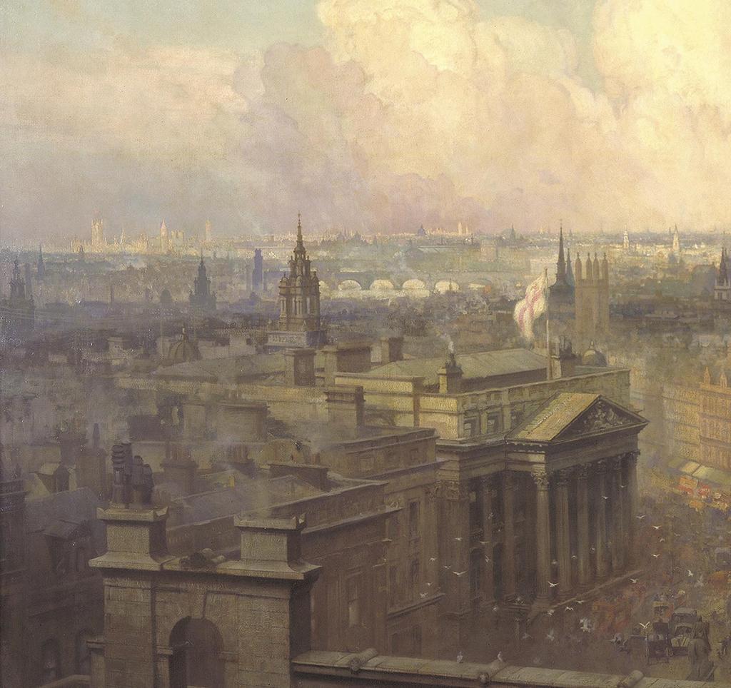
86
 (painted by Niels Moeller Lund, 1904) 79 The Bloomberg site in c 1900")
87 The heart of the empire Looking west from the roof of the Royal Exchange towards St Paul s, with Mansion House, Queen Victoria Street and Cheapside in the foreground (left and centre) (painted by Niels Moeller Lund, 1904) 79 The Bloomberg site in c 1900
88
89 Mithras refound 20th to 21st century
90 Mithras refound: 20th to 21st century The discovery of the mithraeum Most of the buildings on the site are destroyed in But the identification on the bomb site in 1954 of the remains of a Roman temple dedicated to the god Mithras is one of the most amazing archaeological discoveries in Britain of the 20th century; it generates huge press and public interest.
91 The campaign of bombing of British cities, the Blitz, that took place between September 1940 and May 1941, totally destroyed or damaged beyond repair buildings across a third of the City of London. The area around St Paul s Cathedral was hit several times; a particularly severe raid on the night of 10 May 1941 destroyed almost all the buildings on the Bloomberg site. The Blitz was devastating for the people of London and many historic buildings were lost. However, it was recognised that the cleared bomb sites could provide an opportunity to record some of the buried archaeological remains on which the modern city is built. A team of archaeologists was assembled in 1946, called the Roman and Mediaeval London Excavation Council, led by William F Grimes, Director of the London Museum (one of the forerunners of the Museum of London), and another eminent archaeologist, Audrey Williams. Between 1946 and 1961 they examined sites across central London, retrieving valuable information on London s origins. The archaeologists knew the Bloomberg site lay over the Walbrook stream and that wellpreserved organic remains had been seen before in the black, wet soils filling the Walbrook valley. In 1952 they opened several trenches across the Walbrook. The locations chosen were influenced by where bomb rubble had been cleared. In most trenches they found what they expected to see evidence of the reclamation and management of the banks of the Walbrook during the first centuries of Roman London but, in one trench, they uncovered the substantial remains of a Roman stone building with an intriguing curved wall. It was not possible to explore further until more of the bomb rubble had been cleared. The team returned in 1954 and worked through that summer, just before major construction work started for Bucklersbury House, one of the largest post-war developments in the City of London. The fragment of curved wall was shown to extend, and what was revealed was almost the complete floor plan of a large rectangular Roman building, aligned east west, with a semicircular space or apse at the west end. The archaeologists speculated as to what it could be a temple possibly or perhaps even an early church. By the last day of planned excavation, Saturday 18 September 1954, there was no clear indication of who this possible temple could be dedicated to. But that day, allegedly, one of the workmen in the archaeological team made the incredible discovery of a sculpted head. The archaeologists recognised it as the Roman god Mithras, identifiable from his characteristic cap and upwards gaze. At almost the last moment of the excavation, the key piece of information was there: the building could be a temple to Mithras. The story of the discovery was covered in a small article in the Sunday Times the following day with a picture of the Mithras head. Some who had read the story came to the site; this was a time before site security, when London was covered by bomb sites, the playgrounds for a generation of children. Another article came out in The Times on Monday morning, this time much more critical, condemning the imminent destruction of the temple: There is something grievously wrong with our planning if an important antiquity of this sort can be destroyed almost before it has been seen. What other civilised nations may think of the matter is a point upon which one can only speculate apprehensively. 83 The discovery of the mithraeum

92 Timeline 1941 the Blitz destroys buildings on the site The London Blitz The facade of 23 Queen Victoria Street crashes to the street in flames in 1941


93 The Prime Minister, Winston Churchill, asked his Minister of Works, Sir David Eccles, to investigate. Eccles and the excavation director Grimes met on site with representatives of the developers, Legenland, to discuss options. An extension to the excavation was agreed and the archaeologists moved back in. In these extra weeks, the full ground plan of the building was revealed and more fabulous Roman sculptures and artefacts were found, revealing important clues about the worship of the god Mithras and the members of the London cult. The initial press and public interest prompted the archaeologists to arrange for the site to be open for visitors in the evenings. The response was overwhelming: thousands came over the next few days and, as the national press reported on the discovery and newsreels appeared in cinemas, even more came. Lengthy queues 30,000 long grew on the surrounding streets and members of the public waited hours to see the archaeologists at work. Bomb site Looking south-east from Queen Victoria Street across the bomb-damaged site c 1944, with a temporary ARP (air raid precautions) water tank in the foreground and, beyond, St Stephen Walbrook (circled) First sighting Looking west into the basements of 7 8 Walbrook with, left, the curving apse wall revealed in 1952 at the end of the trench 85 The discovery of the mithraeum
![The 1954 excavation William [W F] Grimes on a ladder photographing](/docs-images/72/66430906/images/94-0.jpg "and Audrey Williams below left, standing in the apse of the temple")

94 The 1954 excavation William [W F] Grimes on a ladder photographing and Audrey Williams below left, standing in the apse of the temple Mithras The sculpted head of the young god, from around AD 200, found on what was intended to be the last day of the 1954 excavation

95 Queuing Aerial view of visitors to the site, from Illustrated London News, 2 October The discovery of the mithraeum

96 Remembering 1954 In late September 2014, on the 60th anniversary of the discovery, Bloomberg and MOLA launched an oral history project to find people who had queued to see the original excavation. Hundreds got in touch and spoke of the powerful impact seeing the temple had made on their lives. At a time when London was still recovering from the war, and rationing had only just ended, the temple seemed to capture a sense of hope and pride in London s endurance and continuity. It was quite grim going up to London in those days... so much was broken and still not being cleared away and then out of the bombing of that building had come really the miracle of discovering this temple... Diana Van Rooyen, born 1939, former research psychologist and lecturer

97 It was the first time anything like that had been found in the City of London, it was something unique, nobody had seen anything like it before, not in London. To find a temple almost intact under the streets of London was quite extraordinary. Martin Baker, born 1939, union worker In 1954 I was a 14-year-old schoolboy I knew nothing about archaeology I joined the queue of thousands of people and I thought this was amazing, the discoveries were incredible then I got the thrilling opportunity of digging on the site so I went back and it was an hour and half before I found the corner of a Roman well this was my first day of what was to be a career in archaeology. Peter Marsden, born 1940, archaeologist 89 The discovery of the mithraeum

98 After dismantling Construction of Bucklersbury House begins, 1955, looking towards St Stephen Walbrook

99 The 1960s reconstruction In the following days there were many discussions between the government, the site owners and archaeologists about what should happen to the temple. The costs and delays associated with redesigning the building to accommodate the temple would be significant and the precedent that this would set was alarming to those responsible for reconstruction. The site owners, Legenland, ended the debate by offering to dismantle the temple and re-erect the building somewhere else on the site, all at their own expense. The immediate Mithras crisis was over. In late 1961 work started on the reconstruction and in 1962, eight years after the original discovery, the new temple reconstruction was unveiled on Queen Victoria Street. It was a compromise, built over a car park, nearly 100m from its original location, with many of the architectural features misrepresented and modern building materials used. The original archaeological team and the Ministry of Works were not consulted; Grimes was critical of the reconstruction: The decision of the owners to reconstruct the temple at their own charges was the last of a series of generous acts which was accepted as the answer to the problems of preservation. Unfortunately, it has to be recorded that the final result, now visible on the Queen Victoria Street frontage of Bucklersbury House, falls short of what it ought to have been. Despite its failings, the 1962 reconstruction served as a reminder of the original discovery, found its way into many guidebooks for London and until 2010 even had a bus stop named after it. In 2007 the government s organisation responsible for the historic environment, English Heritage (now Historic England), gave the temple reconstruction statutory protection, as a Grade II listed monument, mainly on account of the original Roman building materials within it, but also recognising it as an early example of heritage conservation. The discovery of the temple of Mithras is an example of the power of archaeology to inspire and inform. However, the whole experience of the queues and the prospect of having to redesign a building had a major impact on how archaeology was perceived within the construction industry throughout the post-war years. The fact that the temple was reconstructed, but off site, arguably put off the difficult decisions about how to treat archaeology on development sites; it was not until the 1990s that a robust system of protection was put in place. The 1962 reconstruction The temple of Mithras (bottom left) reconstructed on Queen Victoria Street, looking south-west; it was removed in The discovery of the mithraeum


100 Roman belief and ritual In Roman London belief in the gods and in magic was widespread, and religious ritual and symbolism were a part of daily life. Some of the best evidence comes from the Walbrook valley where, in addition to the temple of Mithras itself, many objects of religious significance have been found, from figurines to pottery decorated with cult symbols. These provide evidence for belief in many gods, including Venus, goddess of love and beauty, Mercury, god of traders and money, and Bacchus, the god of wine. There were probably several shrines in the valley and the Bloomberg excavations discovered several specialist votives, including figurines and miniature objects left as offerings to the gods. It is possible that even some of the day-to-day objects found at the Bloomberg site were votively deposited at shrines or into the Walbrook stream. Offerings would have aimed to appease the gods and to ensure a long and prosperous existence. Other artefacts can be linked to very personal types of religious and superstitious beliefs, including fragments of domestic shrines and amuletic jewellery worn to ward off bad luck. Right Fragments from a small ceramic shrine or lararium: this example may have contained the household gods, represented by figurines, or been the focus for offerings; cheap mouldmade ceramic shrines and figurines were imported to Roman Britain from Gaul (top, reconstructed width c 160mm; bottom, height 108.7mm)
 Above right")


101 Above A copper-alloy steelyard weight depicting Mercury, god of trade and commerce, with wings in his hair and a traveller s cloak fastened at the shoulder; the owner may have hoped this imagery would encourage the god to look favourably on their dealings (height 28mm) Above right Miniature iron tool set and silver axe head made for use as votive offerings: the choice of object may reflect the identity of the devotee or the character of their request; some of the many full-size iron tools found might also be offerings (knife, length 36mm; axe head, length 16.9mm) Right Amber amulet, perhaps worn by a child, in the shape of a gladiator s helmet; this valuable material was thought to have magical protective and healing properties by the Romans and its shape may also be symbolic of protection (height 13.5mm) 93 The discovery of the mithraeum
102 Mithras refound: 20th to 21st century The mystery of Mithras The Roman god Mithras was worshipped in the 1st 4th centuries AD. A new deity, Mithras was popular with soldiers and merchants. The beliefs and rituals, including initiation, associated with the cult are largely known from archaeological evidence, with much speculation about the meaning of the central icon of Mithras killing a bull the tauroctony.
103 Part of the public fascination with the discovery of the temple was the nature of the cult of Mithras and the religious imagery being uncovered. There were occasional lurid stories in the press, as well as articles from journalists and Roman scholars and archaeologists debating the practices of the cult and asking the question, Who was Mithras?. Mithras was a Roman god, often equated with Sol, the sun god. He first appeared in the Roman empire in the 1st century AD. In the past, scholars believed that Mithras was a direct descendant of the Persian god Mitra, dating from at least 1400 BC, and that Mithraism had spread from the east. We now believe that Mithras was a new Roman invention, adopting some imagery and iconography from Mitra. The cult becomes popular at the same time as other eastern deities that arrived in Rome, including Christianity and the worship of the Egyptian god Isis. Mithras is normally shown as a young man, wearing a characteristic Persian (sometimes referred to as Phrygian) cap. This cap has been associated with liberty in modern times, being worn by republicans in the French Revolution and later (bonnet-rouge), and by the republican personification of the USA, Columbia. In the bull-slaying scene or tauroctony, Mithras typically looks upwards over his right shoulder towards the sun and away from the dying bull, his right hand plunging a dagger into the bull s neck. Sculptures found across the Roman world show other images from Mithras s life, including his birth from a rock, firing an arrow at a rock and bringing forth water, and feasting off the bull. As well as an association with Sol, Mithras is thought to be a god of trust and contracts. However, much is speculation. There are no surviving holy texts for the cult that explain what a worshipper believed or what rituals took place. Most of what we know comes from inscriptions, graffiti and sculptures, and archaeological evidence. There are a few contemporary accounts of the cult from Christian authors, who would have been hostile, but their descriptions of rituals may have elements of truth. The image common to all temples to Mithras is the tauroctony, a scene thought to represent creation or transformation and the bringing of life to the world, and there are almost certainly astrological connections. The iconography suggests familiar religious themes: creation, the human place within the universe, worship of the sun and moon; there is nothing to suggest that a Mithraist believed in an afterlife. Many mithraea, including the Walbrook building, were at least partly subterranean, requiring members to descend into the nave via steps. These recurring features of the design are thought to be an evocation of the cave in which Mithras killed the bull. Mithraea often had vaulted roofs, or at least provided the effect of a vault using wattle and daub covered in plaster, to aid in creating a cavelike scene. This design may also have had another meaning, with the painted vaulted ceiling representing the universe. The evidence from excavated temples indicates that membership of the cult was compatible with worship of the established Roman gods. In the Walbrook temple, sculptures of Minerva, Mars and Mercury would have been visible, as well as cult statues of Mithras. Evidence of initiations and the content of inscriptions suggests that membership of the cult gave privileged access to important knowledge and that Mithras could help you in some way. Archaeological evidence suggests almost theatrical rituals and dramatic initiation ceremonies. Light effects, with torches and lamps behind sculptures, and incense were used. Initiations may have been quite terrifying. One wall painting from Capua (Italy) shows a naked initiate kneeling down, with a man standing behind him with a sword raised; in another scene a man appears to fire an arrow at the initiate. A mithraeum excavated at Guglingen (modern Switzerland) revealed a fake cult sword and a rayed crown that could have been used in rituals. 95 The mystery of Mithras

, with framing panels")
 is Mithras killing")
104 Timeline archaeologist W F Grimes discovers the temple of Mithras Ceremonial sword Bent in a semi-circle at the centre so that it could be placed around the neck to make it appear the person had been stabbed; from the mithraeum at Riegel (Germany) Tauroctony scene Relief in red sandstone from the mithraeum at Neuenheim near Heidelberg (Germany), with framing panels depicting the life of Mithras Inside a mithraeum The interior of the mithraeum below the church of San Clemente, Rome; on the front face of the small votive-altar (centre) is Mithras killing a bull
 to the different grades within the cult.")
105 Many mithraea have produced evidence of feasts, with remains of chicken bones, wine vessels and plates. Graffiti in the mithraeum beneath Santa Prisca, in Rome, provide evidence of what might have been said in a mithraeum a series of chants or hails (nama) to the different grades within the cult. A mithraeum excavated at Ostia (Italy) illustrates this hierarchy within the cult: a mosaic pavement in the central nave is divided into seven grades, each with its own symbols and associated gods and planets. It is unlikely that every member progressed through to the highest level and the existing social strata were probably maintained. Who was a Mithraist? The evidence points to the cult being for men only. Inscriptions appear to show that it was popular with the army, merchants and civil servants; it did not attract the top levels of society, although there was a brief period when it was popular with the imperial elites. It appears to have operated as a belief system that relied on trust and built strong bonds with other men. The evidence for the worship of Mithras fades out in the 4th century AD. Many mithraea show evidence of later iconoclasm the smashing of religious imagery. bench cult statue bench Cult hierarchy The central mosaic in the mithraeum of Felicissimus in Ostia, with the grades in the form of a ladder leading to the cult relief; the lowest grade is the Raven (Corax) and the highest is the Father (Pater) Pater Corax entrance well apse 0 3m KEY Grade Symbols Planet/god Corax (raven) small beaker and the caduceus Mercury Nymphus (bridegroom/ oil lamp and diadem Venus the one who is shrouded) Miles (solider) sling-bag, lance and helmet Mars Leo (lion) fire-shovel, a rattle and thunderbolt Jupiter Perses (Persian) sickle, akinakes (Persian dagger) Venus and a crescent moon Heliodromus (runner of the Sun) torch, seven-rayed crown and a whip the Sun Pater (father) Phyrgian cap, libation bowl, staff and sickle Saturn 97 The mystery of Mithras

106 Mithras and Mithraism Due to a lack of contemporary written sources, scholars studying Mithras are heavily reliant on what can be extrapolated from iconography and from archaeological sites; much of what is known about the cosmology of the cult is derived from its central image, the tauroctony. This depicts Mithras slaying a bull, often surrounded by an array of other symbols, such as the 12 signs of the zodiac; a leaping bull plaque from the Bloomberg excavations may depict Taurus and an earlier find from the site is of Pisces. These finds predate the excavated mithraeum and might suggest that there was an earlier temple to the god nearby. Relatively few other finds from the recent excavation can be suggested as coming from within the Walbrook mithraeum, but a contemporary lead candlestick found just to the north may be an exception; the manipulation of light played a prominent role in Mithraic ritual and a marked concentration of lighting equipment has been found in and around the mithraeum. A group of finds that may be related to the end of the temple s life were found votively deposited down a well shaft to the north (below). Right The marble head of the young god Mithras, in style c AD 200, found on the site in 1954 (height 369mm)
 Right Lead-alloy plaque showing a leaping bull, thought to be the zodiac symbol")

 (height 432mm) 99 The")
107 Above Detail showing the name of Ulpius Silvanus, veteran of the legio II Augusta and perhaps the founder of the temple, inscribed on the left-hand side of the tauroctony marble basrelief (right) Right Lead-alloy plaque showing a leaping bull, thought to be the zodiac symbol Taurus, from the Bloomberg site (length 72mm) Above right Tauroctony marble basrelief, said to have been found on the site in 1889: (centre) Mithras killing a sacred bull in a cave, with a dog, scorpion and snake feasting off the bull, and to either side the two torchbearers, Cautes holding a flaming torch aloft (left) and Cautopates (right) holding the flame down (light and dark, life and death); the encircling band has the 12 signs of the zodiac; inscribed on the left-hand side is the name of Ulpius Silvanus (detail, left) (height 432mm) 99 The mystery of Mithras
108 Mithras refound: 20th to 21st century The Walbrook mithraeum The Walbrook mithraeum is one of the best-preserved temples to Mithras found so far in northern Europe. Built c AD 240 on the banks of the Walbrook stream, apparently in the grounds of a large Roman house, the building undergoes many modifications and may have become a temple to Bacchus before being abandoned in the late 4th century AD.
 long and 4 6m (13 20 feet) wide, and partly underground.")
109 About 100 mithraea are known throughout the Roman world. Most were relatively small and simple buildings, typically rectangular, around 10 12m (33 39 feet) long and 4 6m (13 20 feet) wide, and partly underground. The Walbrook mithraeum was also rectangular, with an anteroom or narthex at the east end, which would have prevented non-members from seeing the rituals. This may also have been a space for preparing food, washing and getting changed. In the main body of the building there was a central nave, where it is thought the rituals took place, with two side aisles for seating, separated from the nave by sleeper walls, with plaster settings on either side for seven columns, perhaps representing the seven grades within the cult. It was larger than a typical mithraeum, measuring c 18m by 8m (59 by 26 feet) for the main cult space, and could have accommodated a congregation of about 30 sitting. Also unusually, it had a rounded apse at the west end in which was a raised platform where the cult statue of Mithras would have stood. The stone head of Mithras found in 1954 is likely to have been used in this statue, with the rest of the body and the bull made of plaster. Mithraea appear to have had no windows and would have been lit by lamps, torches and braziers. Four small holes behind the statue plinth may have carried torches, creating lighting effects. A timber tank or simulated well held water used in rituals. timber drain south buttress well floor joists and planks south aisle central buttress holes apse plinth dais holes steps down nave north buttress north aisle The Walbrook mithraeum, c AD 240 Plan of the temple as excavated and recorded in 1954 The mithraeum was built on the east side of the Walbrook stream, on made-up ground adjacent to the watercourse. Excavations on the east side of modern Walbrook street have revealed evidence of a large Roman building and it is possible that the temple sat in the back garden of a private house. An inscription on the tauroctony relief found in 1889 close to the site of the temple may even give us the name of the original founder: Ulpius Silvanus. narthex 1 south sleeper wall down steps door posts north sleeper wall 0 4m 101 The Walbrook mithraeum
 towards the apse with its tauroctony")
110 Timeline 1962 temple is reconstructed 100m away, on Queen Victoria Street Ritual feasting and initiation Cult followers and their activities feature in this conjectural reconstruction of the interior of the Walbrook mithraeum, looking (west) towards the apse with its tauroctony scene
111 The archaeological evidence for the temple, c AD 240 (scale 1:350) timber-lined well Walbrook channel temple of Mithras excavated 1954 narthex narthex excavated 2011 drain beaten earth floor open ground around temple? private house 0 10m 103 The Walbrook mithraeum

112 The mithraeum east of the Walbrook stream A conjectural reconstruction, c AD 240, looking north-east

113 The Walbrook mithraeum was constructed mainly in ragstone, with some Roman brick and tile, and would have been rendered with a smooth plaster and probably painted. The original floor in the nave would have been made of wooden planks and the side benches and steps were of wood. The building was altered, probably in response to the inevitable damp. A succession of floors of beaten earth and gravel were laid to raise the internal level and various repairs were made as the building moved and cracked on the unstable ground. The building appears to have been in use as a mithraeum until the early 4th century AD when it suffered a serious collapse. and cow skulls, which may have been deposited at the very end of the building s life, in the AD 380s. Limestone voussoirs and tufa recovered from this well are evidence of vaulting (for example, in an alcove or even roof) and probably came from the temple when it was disused. Amazingly, the excavation also showed that some of the original temple still survived, although mainly at foundation level. These sections were too fragile for redisplay and have been carefully recorded and buried beneath the Bloomberg building (below). Following the collapse, the building was remodelled. The columns went (perhaps sold, as no fragments have been found) but, significantly, the marble sculptures of Mithras and other deities were carefully buried in pits dug into the floor (where they were discovered in 1954). The people who altered and rebuilt the temple appear to have worshipped another cult, probably that of Bacchus, but they chose to treat the earlier religious objects with respect. This other phase of worship continued until the late 4th century AD when the temple fell into disuse. The upper levels of masonry were robbed by generations of later Londoners, and what was left was buried beneath centuries of soil and later development. By the 20th century modern ground level was nearly 7m (23 feet) above the 3rd-century AD Roman streets. The archaeological investigations associated with the Bloomberg site gave further intriguing insights into the temple. More of the anteroom or narthex was excavated and this appears to have been divided into several rooms; a drain suggests there could have been a space for washing. Column bases from the later phase of the building were found and a well (below) to the north of the temple contained a collection of pewter vessels, a lead tank Bacchic group marble sculpture One of the sculptures of deities recovered from the Walbrook mithraeum in 1954: Bacchus is centre, supported (right) by a Satyr, with a Maenad to his side; Silenus is lower left (height 343mm) 105 The Walbrook mithraeum

114 Objects from the well A late Roman well was excavated just to the north of the temple. Towards its base a remarkable collection of objects were discovered that were probably deliberate votive deposits. They date to around the time the temple went out of use and it is possible that they came from within it. These include a hoard of pewter vessels and a fragment of a decorated lead tank; such objects have been found in votive deposits elsewhere. Also present were some late Roman militarystyle dress accessories, perhaps reflecting the presence of high-status men. Such individuals are obvious candidates for members of the male-only cult of Mithras with its strong military links. However, it is not certain that the temple was still dedicated to the god at this late date and the same well also produced a 4th-century AD copper-alloy bracelet more probably worn by a woman. Left Fragment of a copper-alloy strap end: the tip is flanked by crouching dogs with stylised incised faces, incised fur on the torsos and undecorated rear legs and haunches (length 47.5mm)
 107 The Walbrook")
115 Above and left Four decorated pewter vessels that once formed part of a ritual deposit, being placed together at the bottom of the well (left to right, height 40mm, c 44mm, 63mm, 47mm) 107 The Walbrook mithraeum
116 Mithras refound: 20th to 21st century The new reconstruction The redevelopment of the site by Bloomberg offers an opportunity to improve on the 1960s reconstruction and create a more faithful and meaningful evocation of the temple to Mithras found in the Walbrook valley London Mithraeum.


117 In 2010 Bloomberg acquired the site of Bucklersbury House for their European headquarters. Redevelopment gave the opportunity to improve on the temple of Mithras display. The local authority, the City of London, provided an initial brief: the temple should be reconstructed again, as close as possible to the location of the original Roman structure; the new reconstruction should reflect the original form of the ruin and incorporate as much of the original fabric as possible, using appropriate and sympathetic new materials where necessary. There were many debates about the correct conservation approach to take. It was recognised that the unreal nature of the surviving structure provided a great opportunity to be creative with the new reconstruction more so than would be possible with in situ Roman remains. Dismantling The 1960s reconstruction on Queen Victoria Street is dismantled in 2011 using diamond-tipped chain saws, enabling almost all of the original material to be recovered intact Sorting the original materials It was clear at this stage that there was not enough original stone and brick left to build a full reconstruction and new materials would have to be sourced; as the original mithraeum was partially rendered, the new stone would be used in areas of render, allowing visitors to see only original stone and mostly original brick 109 The new reconstruction

118 Timeline 2010 Bloomberg acquires the site and plans improved display of temple of Mithras Testing the design concept The design for the display of the mithraeum was mocked-up and tested at a warehouse in Battersea, complete with light and sound effects

119 A key part of the design process was working out how to make the display atmospheric and evoke the feeling of being in a mithraeum. Design company Local Projects won the commission for the exhibition. Working with light artist Matthew Schreiber, they have created walls and columns of light that appear and disappear. Light was thought to be the best medium for creating an impression of the superstructure of the original building as it is less intrusive than projection. And, importantly, scholars think that mithraic rituals played with light: Mithras is often equated with Sol, the sun god, and lighting props have been found on other temple sites, used to create moments of mystery and also probably dramatic effect. The new London Mithraeum exhibition provides visitors with information about the discovery of the temple, its place in Roman London and explores some of the mysteries of the cult. The centrepiece is the new mithraeum reconstruction. The subject of much debate and thought, it is a new Roman artefact, and a space in which to use the imagination and to connect with London s past. London Mithraeum The new reconstruction nearing completion in the Bloomberg building 111 The new reconstruction

120 The design Sectional view of the design for the London Mithraeum Bloomberg SPACE (with thanks to Foster + Partners); archaeological investigation for Bloomberg revealed the eastern foundations of the temple still in situ so the new reconstruction was located about 12m to the west of the original position to allow these remains to be preserved

121 113 The new reconstruction
122 Mithras refound: 20th to 21st century London Mithraeum Bloomberg SPACE The Roman temple of Mithras is returned to where it was discovered in the heart of the City of London.

123 London Mithraeum The temple of Mithras, reconstructed below the Bloomberg building as close as possible to the location of the original Roman structure Situated on the site of Bloomberg s European headquarters, this new cultural space will showcase the reconstructed temple, a selection of the remarkable Roman artefacts found during the recent excavations, and a series of contemporary art commissions responding to one of the UK s most significant archaeological sites. The temple of Mithras, originally constructed c AD 240, was first discovered in during archaeological investigation of a World War II bomb site. It captured the imagination of the public, with an estimated 400,000 people visiting the excavated remains. Today, 7m below modern street level, the new reconstruction will change the way we encounter archaeology, offering visitors an immersive experience and bringing the bustling world of Roman Londinium to life by unlocking the stories behind the city s first Londoners. London Mithraeum Bloomberg SPACE, 12 Walbrook, London, EC4N 8AA Visit London Mithraeum Bloomberg SPACE

124 Forgotten streams One of the artists commissioned to respond to the Bloomberg site and its architecture is Christina Iglesias and, like the ancient Walbrook stream, her Forgotten streams stretches across the Bloomberg site; it takes the form of three bronze bas-reliefs sculpted and layered from casts of branches and leaves, and incorporating water

125 London Mithraeum Discover Mithras: the exhibition on the mezzanine level explores the rituals and beliefs of the cult 117 London Mithraeum Bloomberg SPACE

126 London Mithraeum The central icon of the cult is an image of Mithras killing a bull; clues to what form the cult took are explored in light and sound in the mezzanine space

127 Bloomberg archaeological publication MOLA is publishing a series of monographs describing the Roman occupation of the Bloomberg site and the finds from it. The first of these, Roman London s first voices, focusing on the writing tablets, was published in 2016; it will be followed by volumes detailing the Roman buildings and the thousands of artefacts recovered from the site. Visit Further reading B Barber, C Thomas, and B Watson, 2013 Religion in medieval London: archaeology and belief, London N Bateman, 2011 Roman London s amphitheatre, London R Beck, 2006 The religion of the Mithras cult in the Roman empire, Oxford M Clauss, 2000 The Roman cult of Mithras, translated by Richard Gordon, Edinburgh W F Grimes, 1968 The excavation of Roman and medieval London, London M Henig, 1984 Religion in Roman Britain, London J Hill and P Rowsome, 2011 Roman London and the Walbrook stream crossing: excavations at 1 Poultry and vicinity, City of London, MOLA Monograph Series 37, London P Rowsome, 2000 Heart of the City: Roman, medieval and modern London revealed by archaeology at 1 Poultry, London J Shepherd, 1998 The temple of Mithras, London: excavations by W F Grimes and A Williams at the Walbrook, English Heritage Archaeology Report 12, London R S O Tomlin, 2016 Roman London s first voices: writing tablets from the Bloomberg excavations, , MOLA Monograph Series 72, London Places to visit Guildhall Art Gallery and Roman London s amphitheatre, London EC2V 5AE, for the impressively preserved remains of the eastern end of the amphitheatre in the basement below the art gallery Museum of London, currently at London Wall, London EC2Y 5HN, for extensive displays of finds of all periods from London and interpretation of important themes, plus tours of Billingsgate Roman house and baths on Lower Thames Street The British Museum, London WC1B 3DG, for Roman and other finds from London and the Thames Notes
7. Prehistoric features and an early medieval enclosure at Coonagh West, Co. Limerick Kate Taylor
 7. Prehistoric features and an early medieval enclosure at Coonagh West, Co. Limerick Kate Taylor Illus. 1 Location of the site in Coonagh West, Co. Limerick (based on the Ordnance Survey Ireland map)
THE PRE-CONQUEST COFFINS FROM SWINEGATE AND 18 BACK SWINEGATE
 THE PRE-CONQUEST COFFINS FROM 12 18 SWINEGATE AND 18 BACK SWINEGATE An Insight Report By J.M. McComish York Archaeological Trust for Excavation and Research (2015) Contents 1. INTRODUCTION... 3 2. THE
Greater London GREATER LONDON 3/606 (E ) TQ
 TQ") GREATER LONDON City of London 3/606 (E.01.6024) TQ 30358150 1 PLOUGH PLACE, CITY OF LONDON An Archaeological Watching Brief at 1 Plough Place, City of London, London EC4 Butler, J London : Pre-Construct
GREATER LONDON City of London 3/606 (E.01.6024) TQ 30358150 1 PLOUGH PLACE, CITY OF LONDON An Archaeological Watching Brief at 1 Plough Place, City of London, London EC4 Butler, J London : Pre-Construct
Date: Monday, 6 October :00PM. Location: Museum of London
 Pompeii of the North: Excavations at Bloomberg London and the Return of the Temple of Mithras Transcript Date: Monday, 6 October 2014-1:00PM Location: Museum of London 6 October 2014 Pompeii of the North:
Fort Arbeia and the Roman Empire in Britain 2012 FIELD REPORT
 Fort Arbeia and the Roman Empire in Britain 2012 FIELD REPORT Background Information Lead PI: Paul Bidwell Report completed by: Paul Bidwell Period Covered by this report: 17 June to 25 August 2012 Date
Greater London Region GREATER LONDON 3/567 (E.01.K099) TQ BERMONDSEY STREET AND GIFCO BUILDING AND CAR PARK
 TQ BERMONDSEY STREET AND GIFCO BUILDING AND CAR PARK") GREATER LONDON 3/567 (E.01.K099) TQ 33307955 156-170 BERMONDSEY STREET AND GIFCO BUILDING AND CAR PARK Assessment of an Archaeological Excavation at 156-170 Bermondsey Street and GIFCO Building and Car
GREATER LONDON 3/567 (E.01.K099) TQ 33307955 156-170 BERMONDSEY STREET AND GIFCO BUILDING AND CAR PARK Assessment of an Archaeological Excavation at 156-170 Bermondsey Street and GIFCO Building and Car
LE CATILLON II HOARD. jerseyheritage.org Association of Jersey Charities, No. 161
 LE CATILLON II HOARD CELTIC TRIBES This is a picture of the tribal structure of the Celtic Society CELTIC TRIBES Can you see three different people in the picture and suggest what they do? Can you describe
The Vikings were people from the lands we call Scandinavia Norway, Sweden and Denmark. Viking means pirate raid and vikingr was used to describe a
 The Vikings were people from the lands we call Scandinavia Norway, Sweden and Denmark. Viking means pirate raid and vikingr was used to describe a seaman or warrior who went on an expedition overseas.
The Old English and Medieval Periods A.D
 The Old English and Medieval Periods A.D. 449-1485 The Sutton Hoo burial site location in Suffolk, England, includes the grave of an Anglo-Saxon king. The site included a ship that was fully supplied for
A Sense of Place Tor Enclosures
 A Sense of Place Tor Enclosures Tor enclosures were built around six thousand years ago (4000 BC) in the early part of the Neolithic period. They are large enclosures defined by stony banks sited on hilltops
Cambridge Archaeology Field Group. Fieldwalking on the Childerley Estate, Cambridgeshire. Autumn 2014 to Spring Third interim report
 Cambridge Archaeology Field Group Fieldwalking on the Childerley Estate, Cambridgeshire Autumn 2014 to Spring 2015 Third interim report Summary Field walking on the Childerley estate of Martin Jenkins
SCOTLAND. Belfast IRISH SEA. Dublin THE REPUBLIC OF IRELAND ENGLAND ENGLISH CHANNEL. Before and After
 ALL ABOUT BRITAIN This book tells the story of the people who have lived in the British Isles, and is packed with fascinating facts and f un tales. The British Isles is a group of islands that consists
Bronze Age 2, BC
 Bronze Age 2,000-600 BC There may be continuity with the Neolithic period in the Early Bronze Age, with the harbour being used for seasonal grazing, and perhaps butchering and hide preparation. In the
3. The new face of Bronze Age pottery Jacinta Kiely and Bruce Sutton
 3. The new face of Bronze Age pottery Jacinta Kiely and Bruce Sutton Illus. 1 Location map of Early Bronze Age site at Mitchelstown, Co. Cork (based on the Ordnance Survey Ireland map) A previously unknown
Cambridge Archaeology Field Group. Fieldwalking on the Childerley Estate Cambridgeshire
 Cambridge Archaeology Field Group Fieldwalking on the Childerley Estate Cambridgeshire 2009 to 2014 Summary Fieldwalking on the Childerley estate of Martin Jenkins and Family has revealed, up to March
Changing People Changing Landscapes: excavations at The Carrick, Midross, Loch Lomond Gavin MacGregor, University of Glasgow
 Changing People Changing Landscapes: excavations at The Carrick, Midross, Loch Lomond Gavin MacGregor, University of Glasgow Located approximately 40 kilometres to the south-west of Oban, as the crow flies
198 S. ALBANS AND HERTS ARCHITECTURAL AND ARCHAEOLOGICAL SOCIETY. REPORT FOR BY WILLIAM PAGE, F.S.A.
 198 S. ALBANS AND HERTS ARCHITECTURAL AND ARCHAEOLOGICAL SOCIETY. REPORT FOR 1898-9. BY WILLIAM PAGE, F.S.A. It is difficult for those who have made no study of the Roman occupation of this country to
Chapter 14. Unlocking the Secrets of Mohenjodaro
 Chapter 14 Unlocking the Secrets of Mohenjodaro Chapter 14 Unlocking the Secrets of Mohenjodaro What can artifacts tell us about daily life in Mohenjodaro? 14.1 Introduction The geography of the Indian
Church of St Peter and St Paul, Great Missenden, Buckinghamshire
 Church of St Peter and St Paul, Great Missenden, Buckinghamshire An Archaeological Watching Brief for the Parish of Great Missenden by Andrew Taylor Thames Valley Archaeological Services Ltd Site Code
Moray Archaeology For All Project
 School children learning how to identify finds. (Above) A flint tool found at Clarkly Hill. Copyright: Leanne Demay Moray Archaeology For All Project ational Museums Scotland have been excavating in Moray
Cetamura Results
 Cetamura 2000 2006 Results A major project during the years 2000-2006 was the excavation to bedrock of two large and deep units located on an escarpment between Zone I and Zone II (fig. 1 and fig. 2);
Fieldwalking at Cottam 1994 (COT94F)
") Fieldwalking at Cottam 1994 (COT94F) Tony Austin & Elizabeth Jelley (19 Jan 29) 1. Introduction During the winter of 1994 students from the Department of Archaeology at the University of York undertook
Fieldwalking at Cottam 1994 (COT94F) Tony Austin & Elizabeth Jelley (19 Jan 29) 1. Introduction During the winter of 1994 students from the Department of Archaeology at the University of York undertook
Life and Death on a Romano-British estate: Turnershall Farm in Hertfordshire
 Introduction Life and Death on a Romano-British estate: Turnershall Farm in Hertfordshire In 2002 metal detectorists discovered two of the most significant burials to come from Roman Britain. The objects
This is a repository copy of Anglo-Saxon settlements and archaeological visibility in the Yorkshire Wolds.
 This is a repository copy of Anglo-Saxon settlements and archaeological visibility in the Yorkshire Wolds. White Rose Research Online URL for this paper: http://eprints.whiterose.ac.uk/1172/ Book Section:
Colchester Archaeological Trust Ltd. A Fieldwalking Survey at Birch, Colchester for ARC Southern Ltd
 Colchester Archaeological Trust Ltd A Fieldwalking Survey at Birch, Colchester for ARC Southern Ltd November 1997 CONTENTS page Summary... 1 Background... 1 Methods... 1 Retrieval Policy... 2 Conditions...
Oil lamps (inc early Christian, top left) Sofia museum
 Sofia museum") Using the travel award to attend a field school in Bulgaria was a valuable experience. Although there were some issues with site permissions which prevented us from excavating, I learned much about archaeological
Using the travel award to attend a field school in Bulgaria was a valuable experience. Although there were some issues with site permissions which prevented us from excavating, I learned much about archaeological
St Germains, Tranent, East Lothian: the excavation of Early Bronze Age remains and Iron Age enclosed and unenclosed settlements
 Proc Soc Antiq Scot, 128 (1998), 203-254 St Germains, Tranent, East Lothian: the excavation of Early Bronze Age remains and Iron Age enclosed and unenclosed settlements Derek Alexander* & Trevor Watkinsf
Chapter 2. Remains. Fig.17 Map of Krang Kor site
 Chapter 2. Remains Section 1. Overview of the Survey Area The survey began in January 2010 by exploring the site of the burial rootings based on information of the rooted burials that was brought to the
Sussex, East Lewes Seaford Overlooking the mouth of the Cuckmere River on the W bank. Field Visit 2001/06/28
 5. Annex COMPONENTS OF DEFENCE AREA 14 Details of the defence works shown on Maps 2 and 3 are given below. The listing is arranged in sequence of the unique database record numbers that are also given
A COIN OF OFFA FOUND IN A VIKING-AGE BURIAL AT VOSS, NORWAY. Bergen Museum.
 A COIN OF OFFA FOUND IN A VIKING-AGE BURIAL AT VOSS, NORWAY. BY HAAKON SCHETELIG, Doct. Phil., Curator of the Bergen Museum. Communicated by G. A. AUDEN, M.A., M.D., F.S.A. URING my excavations at Voss
An archaeological evaluation at 16 Seaview Road, Brightlingsea, Essex February 2004
 An archaeological evaluation at 16 Seaview Road, Brightlingsea, Essex February 2004 report prepared by Kate Orr on behalf of Highfield Homes NGR: TM 086 174 (c) CAT project ref.: 04/2b ECC HAMP group site
STUDENT ACTIVITY SHEETS Lullingstone Roman Villa
 STUDENT ACTIVITY SHEETS Lullingstone Roman Villa This resource pack has been designed to help students step into the story of Lullingstone Roman Villa, which provides essential insight into the lives of
ARCHAEOLOGICAL EVALUATION AT BRIGHTON POLYTECHNIC, NORTH FIELD SITE, VARLEY HALLS, COLDEAN LANE, BRIGHTON. by Ian Greig MA AIFA.
 ARCHAEOLOGICAL EVALUATION AT BRIGHTON POLYTECHNIC, NORTH FIELD SITE, VARLEY HALLS, COLDEAN LANE, BRIGHTON by Ian Greig MA AIFA May 1992 South Eastern Archaeological Services Field Archaeology Unit White
39, Walnut Tree Lane, Sudbury (SUY 073) Planning Application No. B/04/02019/FUL Archaeological Monitoring Report No. 2005/112 OASIS ID no.
 Planning Application No. B/04/02019/FUL Archaeological Monitoring Report No. 2005/112 OASIS ID no.") 39, Walnut Tree Lane, Sudbury (SUY 073) Planning Application No. B/04/02019/FUL Archaeological Monitoring Report No. 2005/112 OASIS ID no. 9273 Summary Sudbury, 39, Walnut Tree Lane, Sudbury (TL/869412;
39, Walnut Tree Lane, Sudbury (SUY 073) Planning Application No. B/04/02019/FUL Archaeological Monitoring Report No. 2005/112 OASIS ID no. 9273 Summary Sudbury, 39, Walnut Tree Lane, Sudbury (TL/869412;
Viking Loans Box. Thor s Hammer
 Thor s Hammer Thor is the Viking god of storms and strength. He made thunder by flying across the sky in his chariot and is the most powerful Viking god. Thor is the protector of the other gods and uses
BRITISH HISTORY (-,1603) Lukáš Čejka Kultura a reálie anglofonních zemí a ČR APIN LS 2017/18
 Lukáš Čejka Kultura a reálie anglofonních zemí a ČR APIN LS 2017/18") 1 BRITISH HISTORY (-,1603) Lukáš Čejka Kultura a reálie anglofonních zemí a ČR APIN LS 2017/18 2 OVERVIEW OF EARLY BRITISH HISTORY Stone Age The Neolithic Bronze Age Iron Age The Romans The Invasions Anglo
1 BRITISH HISTORY (-,1603) Lukáš Čejka Kultura a reálie anglofonních zemí a ČR APIN LS 2017/18 2 OVERVIEW OF EARLY BRITISH HISTORY Stone Age The Neolithic Bronze Age Iron Age The Romans The Invasions Anglo
An early pot made by the Adena Culture (800 B.C. - A.D. 100)
") Archaeologists identify the time period of man living in North America from about 1000 B.C. until about 700 A.D. as the Woodland Period. It is during this time that a new culture appeared and made important
Archaeologists identify the time period of man living in North America from about 1000 B.C. until about 700 A.D. as the Woodland Period. It is during this time that a new culture appeared and made important
Former Whitbread Training Centre Site, Abbey Street, Faversham, Kent Interim Archaeological Report Phase 1 November 2009
 Former Whitbread Training Centre Site, Abbey Street, Faversham, Kent Interim Archaeological Report Phase 1 November 2009 SWAT. Archaeology Swale and Thames Archaeological Survey Company School Farm Oast,
Test-Pit 3: 31 Park Street (SK )
") -Pit 3: 31 Park Street (SK 40732 03178) -Pit 3 was excavated in a flower bed in the rear garden of 31 Park Street, on the northern side of the street and west of an alleyway leading to St Peter s Church,
-Pit 3: 31 Park Street (SK 40732 03178) -Pit 3 was excavated in a flower bed in the rear garden of 31 Park Street, on the northern side of the street and west of an alleyway leading to St Peter s Church,
INGRAM GALLERY FEBRUARY 23 MAY 28, 2018
 Cover: Statue head of Augustus (Rome, Italy), ca. 30 BCE. Marble, 14 3/4 x 8 1/4 x 8 5/8 in. The British Museum, 1888,1210.1. The Trustees of the British Museum INGRAM GALLERY FEBRUARY 23 MAY 28, 2018
Peace Hall, Sydney Town Hall Results of Archaeological Program (Interim Report)
") Results of Archaeological Program (Interim Report) Background The proposed excavation of a services basement in the western half of the Peace Hall led to the archaeological investigation of the space in
Results of Archaeological Program (Interim Report) Background The proposed excavation of a services basement in the western half of the Peace Hall led to the archaeological investigation of the space in
Suburban life in Roman Durnovaria
 Suburban life in Roman Durnovaria Additional specialist report Finds Ceramic building material By Kayt Brown Ceramic building material (CBM) Kayt Brown A total of 16420 fragments (926743g) of Roman ceramic
Grim s Ditch, Starveall Farm, Wootton, Woodstock, Oxfordshire
 Grim s Ditch, Starveall Farm, Wootton, Woodstock, Oxfordshire An Archaeological Recording Action For Empire Homes by Steve Ford Thames Valley Archaeological Services Ltd Site Code SFW06/118 November 2006
The Vikings Begin. This October, step into the magical, mystical world of the early Vikings. By Dr. Marika Hedin
 This October, step into the magical, mystical world of the early Vikings The Vikings Begin By Dr. Marika Hedin Director of Gustavianum, Uppsala University Museum This richly adorned helmet from the 7th
Opium Cabin excavation Passport In Time July 21-25, 2014
 Opium Cabin excavation Passport In Time July 21-25, 2014 Page 1 of 14 Non-American Indian settlement of the southern Blue Mountains began with the discovery of gold in drainages of the John Day River in
Ancient Chinese Chariots
 Reading Practice Ancient Chinese Chariots A The Shang Dynasty or Yin Dynasty, according to traditional historiography, ruled in the Yellow River valley in the second millennium. Archaeological work at
Excavations at Shikarpur, Gujarat
 Excavations at Shikarpur, Gujarat 2008-2009 The Department of Archaeology and Ancient History, the M. S. University of Baroda continued excavations at Shikarpur in the second field season in 2008-09. In
THE ALFRED JEWEL: AD STIRRUP: AD THE CUDDESDON BOWL: AD c600 ABINGDON SWORD: AD C875
 STIRRUP: AD 950 1050 THE ALFRED JEWEL: AD 871 899 Found in 1693, ploughed up in a field at North Petherton, Somerset. Found only a few miles from Athelney Abbey where Alfred planned his counter-attack
STONES OF STENNESS HISTORIC ENVIRONMENT SCOTLAND STATEMENT OF SIGNIFICANCE
 Property in Care (PIC) ID: PIC321 Designations: Scheduled Monument (SM90285); Taken into State care: 1906 (Guardianship) Last reviewed: 2003 HISTORIC ENVIRONMENT SCOTLAND STATEMENT OF SIGNIFICANCE STONES
Archaeological sites and find spots in the parish of Burghclere - SMR no. OS Grid Ref. Site Name Classification Period
 Archaeological sites and find spots in the parish of Burghclere - SMR no. OS Grid Ref. Site Name Classification Period SU45NE 1A SU46880 59200 Ridgemoor Farm Inhumation Burial At Ridgemoor Farm, on the
EXECUTIVE SUMMARY. 1. Brief Description of item(s)
") EXECUTIVE SUMMARY 1. Brief Description of item(s) What is it? A figurine of a man wearing a hooded cloak What is it made of? Copper alloy What are its measurements? 65 mm high, 48mm wide and 17 mm thick,
EXECUTIVE SUMMARY 1. Brief Description of item(s) What is it? A figurine of a man wearing a hooded cloak What is it made of? Copper alloy What are its measurements? 65 mm high, 48mm wide and 17 mm thick,
Novington, Plumpton East Sussex
 Novington, Plumpton East Sussex The Flint Over 1000 pieces of flintwork were recovered during the survey, and are summarised in Table 0. The flint is of the same types as found in the previous survey of
The Literature of Great Britain Do you refer to England, Great Britain, and the United Kingdom interchangeably?
 The Literature of Great Britain Do you refer to England, Great Britain, and the United Kingdom interchangeably? http://www.cnn.com/world/meast/9902/ 14/lockerbie/great.britain.map.jpg UNITED KINGDOM shortened
THE UNFOLDING ARCHAEOLOGY OF CHELTENHAM
 THE UNFOLDING ARCHAEOLOGY OF CHELTENHAM The archaeology collection of Cheltenham Art Gallery & Museum contains a rich quantity of material relating to the prehistoric and Roman occupation of the North
New Composting Centre, Ashgrove Farm, Ardley, Oxfordshire
 New Composting Centre, Ashgrove Farm, Ardley, Oxfordshire An Archaeological Watching Brief For Agrivert Limited by Andrew Weale Thames Valley Archaeological Services Ltd Site Code AFA 09/20 August 2009
BALNUARAN. of C LAVA. a prehistoric cemetery. A Visitors Guide to
 A Visitors Guide to BALNUARAN of C LAVA a prehistoric cemetery Milton of Clava Chapel (?) Cairn River Nairn Balnuaran of Clava is the site of an exceptionally wellpreserved group of prehistoric burial
An archaeological evaluation at the Blackwater Hotel, Church Road, West Mersea, Colchester, Essex March 2003
 An archaeological evaluation at the Blackwater Hotel, Church Road, West Mersea, Colchester, Essex report prepared by Laura Pooley on behalf of Dolphin Developments (U.K) Ltd NGR: TM 0082 1259 CAT project
Special School Days
 DOVER Education at museum Special School Days 2017-2018 Helping to inspire pupil s curiosity DOVER Education at museum Special School Days 2017-2018 Welcome to the 2017-2018 Schools Special Activity Days
Evolution of the Celts Unetice Predecessors of Celts BCE Cultural Characteristics:
 Evolution of the Celts Unetice Predecessors of Celts 2500-2000 BCE Associated with the diffusion of Proto-Germanic and Proto-Celto-Italic speakers. Emergence of chiefdoms. Long-distance trade in bronze,
THE RAVENSTONE BEAKER
 DISCOVERY THE RAVENSTONE BEAKER K. J. FIELD The discovery of the Ravenstone Beaker (Plate Xa Fig. 1) was made by members of the Wolverton and District Archaeological Society engaged on a routine field
Xian Tombs of the Qin Dynasty
 Xian Tombs of the Qin Dynasty By History.com, adapted by Newsela staff In 221 B.C., Qin Shi Huang became emperor of China, and started the Qin Dynasty. At this time, the area had just emerged from over
Advanced archaeology at the archive. Museum of London Support materials AS/A2 study day
 Advanced archaeology at the archive Support materials AS/A2 study day Contents National Curriculum links and session description 1-2 Example timetable 3 Practical guidelines 4 Visit preparation and pre-visit
Unit 6: New Caledonia: Lapita Pottery. Frederic Angleveil and Gabriel Poedi
 Unit 6: New Caledonia: Lapita Pottery Frederic Angleveil and Gabriel Poedi Facts Capital Main islands Highest point Language Government Noumea Grande Terre, 3 Loyalty Islands and numerous reefs and atolls
UNIVERSITY OF LANCASTER ARCHAEOLOGY CONFERENCE. 9 March 2002
 UNIVERSITY OF LANCASTER CENTRE FOR NORTH-WEST REGIONAL STUDIES ARCHAEOLOGY CONFERENCE 9 March 2002 A Chairman's Reflections - David Shotter Over the past thirty years, this Conference has become an established
Built Heritage Inventory
 Castlecliff Pill Boxes Register Item Number: 91 Building Type: Residential Commercial Industrial Recreation Institutional Agriculture Other Location: Castlecliff Beach, Whanganui Heritage NZ Pouhere Taonga
British Museum's Afghan exhibition extended due to popular demand
 City Tourism British Museum's Afghan exhibition extended due to popular demand ITM correspondent The British Museum's exhibition Afghanistan: Crossroads of the Ancient World has been extended until 17
Evidence for the use of bronze mining tools in the Bronze Age copper mines on the Great Orme, Llandudno
 Evidence for the use of bronze mining tools in the Bronze Age copper mines on the Great Orme, Llandudno Background The possible use of bronze mining tools has been widely debated since the discovery of
KNAP OF HOWAR HISTORIC ENVIRONMENT SCOTLAND STATEMENT OF SIGNIFICANCE. Property in Care (PIC) ID: PIC301 Designations:
 ID: PIC301 Designations:") Property in Care (PIC) ID: PIC301 Designations: Scheduled Monument (SM90195) Taken into State care: 1954 (Guardianship) Last reviewed: 2004 HISTORIC ENVIRONMENT SCOTLAND STATEMENT OF SIGNIFICANCE KNAP
Property in Care (PIC) ID: PIC301 Designations: Scheduled Monument (SM90195) Taken into State care: 1954 (Guardianship) Last reviewed: 2004 HISTORIC ENVIRONMENT SCOTLAND STATEMENT OF SIGNIFICANCE KNAP
Control ID: Years of experience: Tools used to excavate the grave: Did the participant sieve the fill: Weather conditions: Time taken: Observations:
 Control ID: Control 001 Years of experience: No archaeological experience Tools used to excavate the grave: Trowel, hand shovel and shovel Did the participant sieve the fill: Yes Weather conditions: Flurries
Teachers Pack
 Whitehorse Hill: A Prehistoric Dartmoor Discovery 13.09.14-13.12.14 Teachers Pack CONTENTS About the Teachers Pack 05 Introduction to the exhibition 05 Prehistoric Britain - Timeline 05 What changed? Technology,
Raiders, Traders and Explorers
 Raiders, Traders and Explorers A History of the Viking Expansion Week 2: March 13 th, 2015 Anglo-Scandinavian runic cross-shaft (the Tunwini cross ), Church of St. Mary and St. Michael, Urswick, Cumbria,
ROMAN OBJECTS FROM LANCASHIRE AND CUMBRIA: A ROUND-UP OF FINDS REPORTED VIA THE PORT ABLE ANTIQUITIES SCHEME IN 2006
 ROMAN OBJECTS FROM LANCASHIRE AND CUMBRIA: A ROUND-UP OF FINDS REPORTED VIA THE PORT ABLE ANTIQUITIES SCHEME IN 2006 Dot Bruns INTRODUCTION The Portable Antiquities Scheme is a voluntary scheme to record
The Shang Dynasty CHAPTER Introduction. 4 A chariot buried in a Shang ruler's tomb was to serve the king in the afterlife.
 4 A chariot buried in a Shang ruler's tomb was to serve the king in the afterlife. CHAPTER I The Shang Dynasty 20.1 Introduction In Chapter 19, you explored five geographic regions of China. You learned
Silwood Farm, Silwood Park, Cheapside Road, Ascot, Berkshire
 Silwood Farm, Silwood Park, Cheapside Road, Ascot, Berkshire An Archaeological Watching Brief For Imperial College London by Tim Dawson Thames Valley Archaeological Services Ltd Site Code SFA 09/10 April
An archaeological evaluation in the playground of Colchester Royal Grammar School, Lexden Road, Colchester, Essex
 An archaeological evaluation in the playground of Colchester Royal Grammar School, Lexden Road, Colchester, Essex February 2002 on behalf of Roff Marsh Partnership CAT project code: 02/2c Colchester Museum
An archaeological watching brief and recording at Brightlingsea Quarry, Moverons Lane, Brightlingsea, Essex October 2003
 An archaeological watching brief and recording at Brightlingsea Quarry, Moverons Lane, Brightlingsea, Essex commissioned by Mineral Services Ltd on behalf of Alresford Sand & Ballast Co Ltd report prepared
ROMAN AND MEDIEVAL ACTIVITY IN THE UPPER WALBROOK VALLEY: EXCAVATIONS AT MOORGATE, CITY OF LONDON, EC2, 1997
 ROMAN AND MEDIEVAL ACTIVITY IN THE UPPER WALBROOK VALLEY: EXCAVATIONS AT 12 18 MOORGATE, CITY OF LONDON, EC2, 1997 Graham Bruce, Dominic Perring, Tim Stevens and Melissa Melikian SUMMARY In January and
Early Medieval. This PowerPoint includes information on the following images: 53 and 55
 Early Medieval This PowerPoint includes information on the following images: 53 and 55 Key Point 1 Illuminated Manuscripts Transition from scroll to bound books (codices) Allows for preservation of writing
IRAN. Bowl Northern Iran, Ismailabad Chalcolithic, mid-5th millennium B.C. Pottery (65.1) Published: Handbook, no. 10
 Published: Handbook, no. 10") Bowl Northern Iran, Ismailabad Chalcolithic, mid-5th millennium B.C. Pottery (65.1) IRAN Published: Handbook, no. 10 Bowl Iran, Tepe Giyan 2500-2000 B.C. Pottery (70.39) Pottery, which appeared in Iran
Bowl Northern Iran, Ismailabad Chalcolithic, mid-5th millennium B.C. Pottery (65.1) IRAN Published: Handbook, no. 10 Bowl Iran, Tepe Giyan 2500-2000 B.C. Pottery (70.39) Pottery, which appeared in Iran
Annunciation mural. St Martin s is a Grade 2* listed building, because it s important to the nation.
 Welcome to the Church of St Martin of Tours. We hope you enjoy the beauty, peace and wonder of this special place. St Martin s is a Christian church serving the whole community. It has been a place of
Berkshire West Berkshire Tidmarsh E of the River Pang, on footpath running W-E from Sulham Hill to Sulham Lane, N of Oaklands Farm.
 5. Annex COMPONENTS OF DEFENCE AREA 7 Details of the defence works shown on Map 2 are given below. The listing is arranged in sequence of the unique database record numbers that are also given on the map.
Roger Bland Roman gold coins in Britain. ICOMON e-proceedings (Utrecht, 2008) 3 (2009), pp Downloaded from:
 3 (2009), pp Downloaded from:") Roger Bland Roman gold coins in Britain ICOMON e-proceedings (Utrecht, 2008) 3 (2009), pp. 31-43 Downloaded from: www.icomon.org Roman gold coins in Britain Roger Bland Head of Portable Antiquities & Treasure
Roger Bland Roman gold coins in Britain ICOMON e-proceedings (Utrecht, 2008) 3 (2009), pp. 31-43 Downloaded from: www.icomon.org Roman gold coins in Britain Roger Bland Head of Portable Antiquities & Treasure
ROMAN BEDFORDSHIRE - AN OVERVIEW
 ROMAN BEDFORDSHIRE - AN OVERVIEW This information provides a background to the Roman displays that form part of the Luton s Living Landscape gallery in the Museum. The gallery as a whole attempts to illustrate
CLOTH SEAL MEDALS. The transformation of a Cloth Seal into a Medal. By Steve Cox [1]
![CLOTH SEAL MEDALS. The transformation of a Cloth Seal into a Medal. By Steve Cox [1]](/thumbs/87/96923919.jpg "CLOTH SEAL MEDALS. The transformation of a Cloth Seal into a Medal. By Steve Cox [1]") CLOTH SEAL MEDALS The transformation of a Cloth Seal into a Medal By Steve Cox [1] On a cool September afternoon, in a majestic forest nurtured by Lake Michigan, a good friend of mine gave new life to
CLOTH SEAL MEDALS The transformation of a Cloth Seal into a Medal By Steve Cox [1] On a cool September afternoon, in a majestic forest nurtured by Lake Michigan, a good friend of mine gave new life to
Anglo-Saxons. Gallery Activities
 A Anglo-Saxons Gallery Activities Learning & Information Department Telephone +44 (0)20 7323 8511/8854 Facsimile +44 (0)20 7323 8855 education@thebritishmuseum.ac.uk Great Russell Street London WC1B 3DG
PART 2 TEACHERS NOTES GO ROMAN THEME 3: OFF DUTY LET S INVESTIGATE NOTES AND OBJECT CHECKLIST
 PART 2 TEACHERS NOTES GO ROMAN THEME 3: LET S INVESTIGATE NOTES AND OBJECT CHECKLIST GO ROMAN THEME 3: When on duty, the soldiers were occupied with training, patrolling the Wall and carrying out maintenance
ECFN/Nomisma, Nieborow The Portable Antiquities Scheme Hoards database and research on radiate hoards from Britain
 ECFN/Nomisma, Nieborow The Portable Antiquities Scheme Hoards database and research on radiate hoards from Britain Roger Bland British Museum Hoarding project Summary of coin hoards from Britain Period
A visit to the Wor Barrow 21 st November 2015
 A visit to the Wor Barrow 21 st November 2015 Following our exploration of Winkelbury a few weeks previously, we fast forwarded 12 years in Pitt Rivers remarkable series of excavations and followed him
h i s t om b an d h i s t r e a su r e s Worksheet CArter ArChAeoLoGY
 1 Worksheet CARTER ARCHAEOLOGY 2 1. Howard Carter s discovery Text A The Valley of the Kings The Valley of the Kings is on the west bank of the Nile, opposite the ancient city of Thebes. Thebes is called
2 Saxon Way, Old Windsor, Berkshire
 2 Saxon Way, Old Windsor, Berkshire An Archaeological Watching Brief For Mrs J. McGillicuddy by Pamela Jenkins Thames Valley Archaeological Services Ltd Site Code SWO 05/67 August 2005 Summary Site name:
1. Introduction. 2. A Shang Capital City
 1. Introduction In ancient times, most of China s early farmers settled on the North China Plain, near the Huang He (Yellow River). In this chapter, you will explore one of China s earliest dynasties,
Contact Details The Collection: Art & Archaelogoy in Lincolnshire Danes Terrace, Lincoln LN2 1LP Tel: +44 (0)
") Contact Details The Collection: Art & Archaelogoy in Lincolnshire Danes Terrace, Lincoln LN2 1L Tel: +44 (0)1522 550990 www.thecollectionmuseum.com Opening Times Open daily 10am - 4pm Free Entry For Investigate
Contact Details The Collection: Art & Archaelogoy in Lincolnshire Danes Terrace, Lincoln LN2 1L Tel: +44 (0)1522 550990 www.thecollectionmuseum.com Opening Times Open daily 10am - 4pm Free Entry For Investigate
Please see our website for up to date contact information, and further advice.
 On 1st April 2015 the Historic Buildings and Monuments Commission for England changed its common name from to Historic England. We are now re-branding all our documents. Although this document refers to,
A Summer of Surprises: Gezer Water System Excavation Uncovers Possible New Date. Fig. 1, Gezer Water System
 Can You Dig It A Summer of Surprises: Gezer Water System Excavation Uncovers Possible New Date Posted: 14 Sep 2016 07:29 AM PDT By Dan Warner and Eli Yannai, Co-Directors of the Gezer Water System Excavations
Durham, North Carolina
 Durham, North Carolina 27708-0103 Department of Classical Studies Telephone: (919) 681-4292 Box 90103, 233 Allen Building Fax: (919) 681-4262 classics@duke.edu http://www.classicalstudies.duke.edu Cultural
Guided tours and talks. Museum of London talks and tours
 Guided tours and talks Start your visit to London here with over 450,000 years of history! With two venues, shops, cafés, tours, talks, and extensive collections covering London s history from prehistoric
Archaeological trial-trenching evaluation at Chappel Farm, Little Totham, Essex. April 2013
 Archaeological trial-trenching evaluation at Chappel Farm, Little Totham, Essex April 2013 report prepared by Ben Holloway commissioned by Tim Harbord Associates on behalf of Mr Tom Howie Planning reference:
Archaeological Material From Spa Ghyll Farm, Aldfield
 Archaeological Material From Spa Ghyll Farm, Aldfield Introduction Following discussions with Linda Smith the Rural Archaeologist for North Yorkshire County Council, Robert Morgan of 3D Archaeological
Essex Historic Environment Record/ Essex Archaeology and History
 Essex Historic Environment Record/ Essex Archaeology and History CAT Report 578 Summary sheet Address: Kingswode Hoe School, Sussex Road, Colchester, Essex Parish: Colchester NGR: TL 9835 2528 Type of
Conditional Use Permit case no. CU13-07: Arsenal Tattoo
 PLANNING AND ZONING COMMISSION STAFF REPORT August 1, 2013 Conditional Use Permit case no. CU13-07: Arsenal Tattoo CASE DESCRIPTION: LOCATION: LEGAL DESCRIPTION: EXISTING LAND USE: APPLICANT(S): STAFF