Middle Woodland Mound Distribution and Ceremonialism in the Apalachicola Valley, Northwest Florida
|
|
|
- Joel Taylor
- 6 years ago
- Views:
Transcription


1 University of South Florida Scholar Commons Graduate Theses and Dissertations Graduate School Middle Woodland Mound Distribution and Ceremonialism in the Apalachicola Valley, Northwest Florida Anya C. Frashuer University of South Florida Follow this and additional works at: Part of the American Studies Commons Scholar Commons Citation Frashuer, Anya C., "Middle Woodland Mound Distribution and Ceremonialism in the Apalachicola Valley, Northwest Florida" (2006). Graduate Theses and Dissertations. This Thesis is brought to you for free and open access by the Graduate School at Scholar Commons. It has been accepted for inclusion in Graduate Theses and Dissertations by an authorized administrator of Scholar Commons. For more information, please contact
2 Middle Woodland Mound Distribution and Ceremonialism in the Apalachicola Valley, Northwest Florida by Anya C. Frashuer A thesis submitted in partial fulfillment of the requirements for the degree of Master of Arts Department of Anthropology College of Arts and Sciences University of South Florida Major Professor: Nancy Marie White, Ph.D. Brent R. Wesiman, Ph.D. E. Christian Wells, Ph.D. Mark R. Hafen, Ph.D. Date of Approval: April 14, 2006 Keywords: Middle Woodland, Swift Creek, Weeden Island, Poplar Springs Mound, pottery, exotics, copper, mica, exchange, burial practices. Copyright by Anya C. Frashuer 2006
3 Dedication This is dedicated to those who have passed this year and are unable to celebrate this accomplishment with me: Mildred Aunt Millie Landen, Lillian Aunt Nan Brigham and Mary Grandma Frashuer. I know they are looking down from heaven and sharing in my joy.
4 Acknowledgments Special thanks to: My committee Brent Weisman, Christian Wells, Mark Hafen and especially my chair Nancy Marie White for their guidance and help through this process. The brothers to whom this collection was entrusted and for their desire to have it reintegrated into the archaeological world. I would like to thank them for providing all the information they could to help relocate the mound from which it came and for taking the time to talk with us, search with us, and let us into their home to document the collection. Jeff Whitfield, without whom I wouldn t know as much as I do about the archaeology of the Apalachicola Valley or surviving the wilds of Russia. He has been a wonderful local informant and guide. My parents, grandparents, aunts and uncles who have always supported me in my pursuit of and paid for the education that got me to where I am now. Roy Price, who has always believed in me, made me take an honest look at myself and my abilities, and was my biggest cheerleader. He went through this and was helpful in letting me know what to expect, especially when it came to writing. My baby sitter, where ever you are, who started the seed in me as an infant. The teachers and playground monitors at Trinity Episcopal Church, who trusted me enough to allow me the freedom during recess that eventually led to my love of archaeology. And to all those who listened to my ideas and my moaning over the years and who were kind enough to keep me stocked in soda and chocolate.
5 Table of Contents List of Tables List of Figures Abstract iii iv viii Chapter 1: Introduction 1 Purpose of Study 2 Background 4 Middle Woodland in the Southeastern United States 4 Swift Creek and Weeden Island in the Apalachicola Valley 6 Geographic Area 9 Chapter 2: Poplar Springs Mound 11 Introduction 11 History of the Collection 14 Poplar Springs Mound 16 The Donated Pottery 27 Discussion 31 Chapter 3: Middle Woodland Mounds in the Valley 33 Introduction 33 The Middle Woodland Mounds 39 Davis Field, 8Ca1 39 OK Landing, 8Ca2 39 Gaston Spivey, 8Ca Porter s Bar, 8Fr1 40 Brickyard Creek, 8Fr8 43 Eleven Mile Point, 8Fr10 43 Green Point, 8Fr11 44 Huckleberry Landing, 8Fr12 45 Pierce Mounds, 8Fr14 47 Jackson Mound, 8Fr15 50 Cool Springs Mound, 8Fr19 51 Aspalaga Landing Mound, 8Gd1 51 Mound Near Indian Pass Point, 8Gu1 52 Gotier Hammock, 8Gu2 55 i
6 Burgess Landing, 8Gu3 57 Isabel Hammock, 8Gu4 58 Chipola Cutoff, 8Gu5 59 Richardson s Hammock, 8Gu10 61 Howard Creek Mound, 8Gu41 62 Sampson s Landing, 8Ja1 64 Moore s Mound Near Kemp s Landing, 8Ja2 64 Waddell s Mill Pond Site, 8Ja65 65 Watson s Field, 8Ja93 67 Poplar Springs Mound, 8Ja Patrick Pond, 8Ja Mound Below Bristol, 8Li3 68 Bristol Mound, 8Li4 68 Rock Bluff Landing, 8Li5 69 Michaux Log Landing, 8Li6 71 Estiffanulga, 8Li7 72 Discussion 73 Chapter 4: Archaeological Evidence of Middle Woodland 74 Middle Woodland Material Culture 74 Pottery 74 Stone Tools and Non-utilitarian Stone Artifacts 84 Bone Tools and Non-utilitarian Bone Artifacts 88 Shell Tools and Non-Utilitarian Shell Artifacts 90 Exotic Materials 95 Skeletal Data 101 Fitting in the Lost Mound 107 Chapter 5: 109 Discussion and Analysis 109 Existing Models for Middle Woodland 109 Middle Woodland in the Apalachicola Valley 114 Conclusions 118 References 120 ii
7 List of Tables Table 1 Cultural Periods and Ceramic Series of the Apalachicola Valley 7 Table 2 Pottery from Donated Collection, Poplar Springs Mound 26 Table 3 List of Whole Ceramic Vessels in Marianna Collector s Possession 26 Table 4 Middle Woodland Mounds of the Apalachicola Valley 36 Table 5 Middle Woodland Ceramic Types of the Apalachicola Valley 75 Table 6 Middle Woodland Mound Ceramic Types Distribution 82 Table 7 Middle Woodland Stone Ornaments of the Apalachicola Valley 85 Table 8 Stone Tools at Apalachicola Valley Middle Woodland Mounds 87 Table 9 Table 10 Table 11 Bone Artifacts at Apalachicola Valley Middle Woodland Mounds 88 Shell Artifacts at Apalachicola Valley Middle Woodland Mounds 94 Exotic Artifacts at Apalachicola Valley Middle Woodland Mounds 96 Table 12 Burial Data at Apalachicola Valley Middle Woodland Mounds 103 iii
8 List of Figures Figure 1. Location of the Apalachicola River Valley, Florida. 9 Figure 2. Location of Jackson County in the Florida Panhandle. 12 Figure 3. Whole Pots Still in Possession of the Collector. 15 Figure 4. Figure 5. Indian Springs Golf and Country Club, Marianna, Jackson County, FL. 17 Poplar Springs Village and Mound and Nearby Middle Woodland Sites. 18 Figure 6. Hole 3 of Indian Springs Golf and Country Club. 19 Figure 7. Figure 8. Figure 9. Figure 10. Figure 11. Figure 12. Figure 13. Figure 14. Lithic Tools Recovered from Surface Collection of Poplar Springs Mound. 20 Ceramics Recovered from Surface Collection of Poplar Springs Mound. 20 Swift Creek Sherds Recovered from Poplar Springs Mound by Scott Nidy (DHR) during the 1973 investigation. 22 Undecorated vessels from Poplar Springs Mound still in possession of collector. 23 Keith Incised Vessel from Poplar Springs Mound still in possession of collector. 23 Swift Creek Complicated-Stamped Vessels still in possession of collector. 24 Undecorated, Square-Bottom, Ritually Perforated Vessel still in possession of collector. 24 Swift Creek Complicated-Stamped Vessels with Pointed Bottoms still in possession of collector. 25 iv
9 Figure 15. Figure 16. Swift Creek Complicated-Stamped Pottery donated from Poplar Springs. 28 Crooked River Complicated-Stamped Sherd donated from Poplar Springs Mound. 28 Figure 17. Weeden Island Pottery donated from Poplar Springs Mound. 30 Figure 18. Carrabelle Punctated Pottery donated from Poplar Springs Mound. 30 Figure 19. Mississippian Ceramics donated from Poplar Springs Mound. 31 Figure 20. Middle Woodland Sites of the Apalachicola Valley. 34 Figure 21. Middle Woodland Mounds of the Apalachicola Valley. 35 Figure 22. Swift Creek Complicated-Stamped pottery sherds from Davis Field Mound. 40 Figure 23. Shell artifacts from Porter s Bar in USF collections. 42 Figure 24. Mounds at Porter s Bar. 42 Figure 25. Hematite nodule from Porter s Bar in USF collections. 42 Figure 26. Shell scoop from Huckleberry Landing. 46 Figure 27. Quartz pebble from Huckleberry Landing. 46 Figure 28. Hematite nodule from Huckleberry Landing mound. 46 Figure 29. Swift Creek Complicated-Stamped pottery from Huckleberry Landing mound. 47 Figure 30. Pierce Mound A. 49 Figure 31. Pierce Mound C with ATV track up the center. 50 Figure 32. Mound Near Indian Pass located within the front yard of a residential property. 54 v
10 Figure 33. Shell tools collected from the surface of Mound Near Indian Pass. 54 Figure 34. Scatter of shell and modern refuse northwest of mound. 54 Figure 35. Site of Gotier Hammock mound. 56 Figure 36. Cut mica from Gotier Hammock in private collection. 56 Figure 37. Artifacts collected from the surface of Gotier Hammock in USF collections. 57 Figure 38. Location of Burgess Landing. 58 Figure 39. Location of Chipola Cutoff. 60 Figure 40. Burial mound at Richardson s Hammock. 61 Figure 41. Artifacts from Howard Creek Mound. 63 Figure 42. Howard Creek Mound. 63 Figure 43. Rock Bluff Landing mound. 70 Figure 44. Looter s trench through Micheaux Log Landing. 72 Figure 45. Figure 46. Figure 47. Figure 48. Figure 49. Figure 50. Distribution of Ceramics in the Apalachicola Valley Middle Woodland Mounds. 81 Distribution of Ground Stone Artifacts in the Apalachicola Valley Middle Woodland Mounds. 86 Distribution of Bone Artifacts in the Apalachicola Valley Middle Woodland Mounds. 89 Distribution of Shell Tools in the Apalachicola Valley Middle Woodland Mounds. 91 Distribution of Shell Utensils in the Apalachicola Valley Middle Woodland Mounds. 92 Distribution of Shell Ornaments in the Apalachicola Valley Middle Woodland Mounds. 93 vi
11 Figure 51. Figure 52. Figure 53. Figure 54. Distribution of Exotic Materials in the Apalachicola Valley Middle Woodland Mounds. 98 Cranial Deformation at Apalachicola Valley Middle Woodland Mounds. 101 Distribution of Primary Burials at Apalachicola Valley Middle Woodland Mounds. 104 Distribution of Secondary Burials at Apalachicola Valley Middle Woodland Mounds. 105 Figure 55. Cremations at Apalachicola Valley Middle Woodland Mounds. 106 Figure 56. Potential Sources for Exotic Materials at Apalachicola Valley Middle Woodland Mounds. 116 vii
12 Middle Woodland Mound Distribution and Ceremonialism in the Apalachicola Valley, Northwest Florida Anya C. Frashuer ABSTRACT University of South Florida field investigations in northwest Florida s Apalachicola Valley have resulted in the relocation of some lost mounds from the Middle Woodland period (ca. A.D. 1 to 650) by trekking through the forest and consulting with avocationals and collectors. This thesis project was triggered by a collector s donation of some Swift Creek pots and the attempt to relocate the mound from which they came. In the 1970s, Gardner and Nidy recorded this site, named Poplar Springs Mound, categorized as Middle Woodland due to its Swift Creek and Weeden Island pottery. The donated collection contained pottery of the Swift Creek Complicated-Stamped series, Weeden Island series, and a couple of anomalous Mississippian sherds. To see how this mound fit in with other Middle Woodland mounds of the valley, it was necessary to compile data for all of them and relocate as many mounds as possible through additional survey. Artifact types from these mounds, such as pottery, shell, bone, and exotic materials, and burial practices were tabulated and spatial distributions were plotted. The mounds are distributed along the banks of the main navigable waterways of the Apalachicola and Chipola Rivers, on smaller streams and along the Gulf Coast. Nearly all viii
13 have both Swift Creek and early Weeden Island ceramics, except for three with only Swift Creek types and a single site with only Weeden Island types. The artifact distributions show stone, bone, and shell tools clustering close to the coast and the main waterways. This is also the case for exotic (nonlocal) raw materials and artifacts made from these materials. Copper is distributed mainly along the coast, while other exotics (i.e. mica, galena, hematite) are located along the coast and close to the main rivers. The tabulation of these data, along with the documentation of the Poplar Springs Mound collection, will help archaeologists to see the manifestation of Middle Woodland ceremonial activity in the Apalachicola Valley. ix
14 Chapter 1: Introduction Northwest Florida s Apalachicola Valley is just beginning to be understood archaeologically. Earlier studies of the area by Clarence Bloomfield Moore and Gordon Willey are usually included within overviews of the larger panhandle or statewide area. Over the last 20 years, Nancy White, with the help of countless students, has worked in the Apalachicola Valley to continue documenting its rich cultural history. The research has included relocating some sites documented by the previous archaeologists and continuing to survey the area to locate new sites. The University of South Florida (USF) field program in this valley has included many years of interaction with generous local people, collectors who have spent decades accumulating artifacts from local sites, and who have led USF researchers to relocate some of these mounds. Simpson (1996) and White compiled a comprehensive database of the prehistoric sites along the Apalachicola River based on the work that had already been done by USF and recorded in the Division of Historical Resources (DHR) database. 1
15 Purpose of Study This work documents a Middle Woodland mound and associated donated collection and attempts to summarize all known Middle Woodland mounds and associated material culture in the valley to create a cultural-historical base upon which generalizations of Middle Woodland ceremonialism can be created. Chapter Two consists of the research and documentation of the donated collection that began this thesis work. The purpose was to bring to light this collection from Poplar Springs Mound (8Ja138), which is now destroyed, and determine how this Middle Woodland mound and its Swift Creek and Weeden Island pottery fit in with other Middle Woodland mounds of the valley. Chapter Three describes all Middle Woodland mounds, their archaeological history and material goods, and discusses the distribution of all Middle Woodland sites and mounds. This provides a comprehensive collection of the work done at each of the Middle Woodland sites by past archaeologists, including White and her students, and presents the work that I have done to relocate some mounds and to list all artifacts (from every survey) associated with the mounds. Chapter Four details all material categories and distribution trends of ceramics, stone, shell, bone, and artifacts of exotic raw materials, as well as burial practices and cranial deformation. The tabulation of these data will show how Middle Woodland is manifested in the Apalachicola Valley. This chapter also includes a section on how Poplar Springs Mound compares to the rest of the mounds in the valley. Chapter Five discusses how Middle Woodland in the valley fits into existing models of Middle Woodland in the eastern United States, from northern areas such as the Illinois Hopewell sites, to Swift Creek and Weeden Island sites in the 2
16 Southeast and Florida, including the model proposed by Brose and Percy in 1974 for Middle Woodland ceremonial activity in the Apalachicola Valley. The chapter then offers some conclusions to contribute to the interpretation of Middle Woodland exchange in the Apalachicola. Middle Woodland is a fantastic time in the span of human history of the Southeastern United States. This is the time of the height of mound building, interactions with far-reaching groups, and growing social ranking based on the exchange of exotic goods in the form of raw materials or finished artifacts. The Apalachicola Valley was important for Middle Woodland activity, with communities whose activities expressed these conspicuous burial monuments, intricately designed pottery, and ornate objects of exotic raw materials. With the combination of Cassandra Rae Harper s M.A. thesis (in progress) on ceramic seriation and domestic sites, and evaluating the other 1974 model by Percy and Brose concerning ceramic change, this work will build the culturalhistorical base knowledge of the Middle Woodland groups in the Apalachicola Valley. This research on the ceremonial sites and their exotic items can contribute to research concerning trade and exchange. This work also helps bring to light the collections of many avocational archaeologists who have been working in the area. Without their knowledge of site location and their artifacts, much information about the past peoples of the area would be lost. 3
17 Background Middle Woodland in the Southeastern United States. The general prehistoric cultural adaptation named the Woodland period in the eastern United States spans approximately two thousand years, from about 1000 B.C. to A.D (Anderson and Mainfort 2002). This timeline is not absolute, as the Woodland begins and ends at various times in different areas, and new sites and radiocarbon dates expand or contract the timeline. For scientific convenience, it is divided into three segments: Early, Middle and Late Woodland. The shift from the previous Late Archaic period to the Woodland was originally marked by the appearance of sand-tempered pottery, but today is traditionally marked by a change in subsistence from full-time hunting-gathering-fishing to early food production (gardening/horticulture). There is an increase in emphasis on seed-bearing plants in both foraging and gardening, an increase in the degree of sedentism, and the introduction of new forms of mortuary ritual, which indicate the enhanced prestige of group leaders. The Woodland is also traditionally marked by the earliest mound building in parts of the eastern United States. Early Woodland groups, such as the Adena in the Midwest, constructed the first burial mounds, but fewer are known in the southeast until the Middle Woodland period (Brose and White 1999; Smith 1986; Steponaitis 1986; Swartz 1970; White 1985). Middle Woodland in the Southeastern United States occurs approximately between 200 B.C. and A.D. 400 and is well known for its burial mound construction and 4
18 distinctive artifacts and iconography. These sites have produced large quantities of pottery, stone, shell and bone tools, as well as many varieties of ornamental artifacts often made of exotic raw materials. These sites are usually recognized by the diagnostic Swift Creek and/or early Weeden Island pottery in the Southeast (Anderson and Mainfort 2002:2-9). The crowning achievement of the Middle Woodland was the extensive exchange network involving socially valued goods that moved all over the Midwest and Southeast. It was at this time (about the first three centuries A.D.) that the amount and quality of the goods exchanged increased and interaction between the Midwestern and Southeastern groups grew (Anderson and Mainfort 2002:12; Brose 1985:76-77; Mainfort 1988:145). Hopewell influence is seen at many of the large mound centers in the form of nonlocal materials such as copper, but there was little evidence of interaction or artifacts from Hopewell at the smaller Southeastern mounds or mound groups (Anderson and Mainfort 2002:10, Seeman 1979a). Swift Creek is the ceramic complex characterizing the Middle Woodland in Georgia and Northwest Florida, where it is joined by the Weeden Island ceramic complex. In the Southeast, the Middle Woodland manifestation known as Weeden Island has been classified into eight geographical areas spread across southern Georgia, Alabama, the Florida panhandle and Gulf Coast (Milanich 1994, Milanich et al. 1997, Turner, Kingston and Milanich 2005). The Apalachicola valley is within the Northwest Florida area, which extends to the Aucilla River in the east, Mobile Bay to the west and north approximately to the modern political boundary of Florida. The lower Chattahoochee River is within the Kolomoki area, named after the major mound center 5
19 excavated by Sears (1951a, 1951b, 1953, 1956) and Pluckhahn (2003). The McKeithen site lies within the Weeden Island area called McKeithen, which occupies north-central Florida. The Northwestern Florida Weeden Island area was subdivided by Teser (1980:112), showing distinctions between the groups of the coast and those of the Apalachicola and adjacent inland area. Two major Middle Woodland centers that have contributed to the knowledge of Swift Creek and Weeden Island ceremonial activity are Kolomoki and McKeithen. Kolomoki is a multi-mound center located in southwest Georgia, up the Chattahoochee River from the Apalachicola Valley (Pluckhahn 2003; Sears 1951a, 1951b, 1953, 1956; Steinen 1998). It dates to the late Swift Creek and early Weeden Island, but for a while was considered by Sears as being Post-Swift Creek (Sears 1992). The site contains three burial mounds, two of which were dated to the late Swift Creek (A.D ) and early Weeden Island (A.D ) (Sears 1992:69). McKeithen is a Weeden Island site located in north-central Florida. It was a large village/mound grouping with three mounds associated with the impressive burial rituals (Milanich 1994; Milanich et al. 1997). In this area, Swift Creek does not occur, and early Weeden Island spans A.D , having been preceded by Deptford (Turner et al. 2005:121). Swift Creek and Weeden Island in the Apalachicola Valley. Middle Woodland in the Apalachicola is defined by White (1985; White et al. 1992):16-17) as the period approximately A.D. 1 to 650 (Table 1). Recent unpublished radiocarbon dates have pushed the ending date for Middle Woodland to A.D. 650 from the previously published 6
20 Table 1. Cultural Periods and Ceramic Series of the Apalachicola Valley Cultural Period Ceramics Series Date Range Paleo-Indian pre-ceramic 10, B.C. Archaic Orange B.C. Early Deptford Santa Rosa 1000 B.C. - A.D. 1 Woodland Middle Swift Creek early Weeden Island A.D Late late Weeden Island A.D Mississippian Fort Walton Lamar (Leon-Jackson) A.D A.D Middle Woodland in northwest Florida is named Swift Creek- early Weeden Island because sites have both these characteristic pottery types. Both of these ceramic series are recognized by their distinctive decorations. Swift Creek pottery has intricately stamped complicated and curved designs (Anderson 1998; Snow 1998; Williams and Elliot 1998). Weeden Island pottery has incised or punctated designs made by a sharp implement, cutouts, red painting or effigies protruding from the rims of the pots in the shapes of animals, humans, and other forms (Milanich 1994; White 1985; Willey 1945). Weeden Island and Swift Creek are ceramic traditions, that have become names for archaeological cultures, and may characterize many different societies who use similar pottery techniques at varying intensities (Anderson 1998). It is with the distribution of other materials and the variety of other practices (such as cranial flattening or participation in Hopewellian exchange) that archaeologists can begin to differentiate cultural groups. 7
21 Clarence Bloomfield Moore (1902, 1903, 1907, 1918) was the first archaeologist that we know of to work in the Apalachicola Valley in northwest Florida. He spent many years looking for and excavating prehistoric sites all over the Southeastern United States, mainly by way of steamboat through navigable waters. He was the first in the area to excavate and record all that was found in domestic and mound sites that were relatively accessible from his boat. During a span from 1902 through 1918, he returned to the Apalachicola and Chipola Rivers and the Gulf Coast to record what he saw and throughly excavate many sites. He located 23 Middle Woodland mounds within the watershed and spent much of his time excavating trenches or the whole mound, sometimes writing that the mound was destroyed by his excavations. He was careful to record previous looting and the state of the mound upon his arrival, yet quite often his description of how he left the site (completely dug or only piles around trees) was sometimes in error, and many sites have been relocated with subsurface and even surface stratigraphic sequences intact. Gordon Willey (1945, 1949), who spent time surveying the Florida Gulf Coast in the 1940s, relocated Moore s sites and recorded others in the area. He was instrumental (before Brose and White s 1999 Northwest Florida compilation) in reviewing Moore s notes and setting up the ceramic typology for the region. He relocated four of Moore s Middle Woodland mounds within the Apalachicola. He provided complete lists of artifacts recovered (by Moore and by himself) and also came up with an early model of Middle Woodland groups in the Apalachicola and along the Gulf Coast (Willey 1949). 8

22 Geographic Area The study area is the whole Apalachicola Valley, located in the panhandle of Florida (Figure 1). For the sake of this research, only the area within the Florida political boundaries is considered, which includes the Chipola River and the west bank of the Chattahoochee River that borders lower Georgia. More accurate discussion of prehistoric times would include the rest of the Chattahoochee River Valley that extends northward into Alabama and Georgia. The Apalachicola River is approximately 171 km long (107 navigational miles up from its mouth) and is formed by the joining of the Flint and Chattahoochee Rivers. The river itself is divided into upper, middle, and lower segments, with the highest elevation and narrowest floodplain occurring in the upper river and a Figure 1. Location of the Apalachicola Valley, Florida. The study area encompasses only the section of the valley that is within the modern day political boundaries of Florida. 9
23 gradual flattening of the land and widening of the floodplain as the river flows south to the Gulf of Mexico. The lower river lies within the Gulf Coastal lowlands, which is where the Chipola River empties into the main channel, at navigation mile 28. The river has changed since the time of Woodland occupation, with the construction of the Jim Woodruff Dam in the early 1950s and regular straightening and dredging by the Army Corps of Engineers (Henefield and White 1986). Environmental aspects of the area have changed vastly from the Pleistocene to today. Previous to the largest climatic change 10,000 years ago, conditions were semiarid, with lower sea levels and temperatures (Milanich 1994; Milanich and Fairbanks 1980; Randazzo and Jones 1997). From then on, there were many fluctuations in sea level, which caused changes in animal and plant resources affecting hunting-gathering strategies, with present shorelines established between 7000 and 6000 years ago (Stapor and Tanner 1977). The rich resources and moderate climate of the Apalachicola Valley region offer good settings for Middle Woodland populations. The most spectacular of these sites were the burial mounds. The next chapter discusses one mound in particular, Poplar Springs Mound, that was investigated because of a generous donation of Swift Creek and Weeden Island pottery. 10
24 Chapter 2: Poplar Springs Mound Introduction The University of South Florida (USF) has conducted archaeological research in northwest Florida s Apalachicola Valley for over 20 years. Each year, in addition to research survey and excavation, Nancy White has conducted an archaeology day program somewhere in the Florida panhandle. This work has provided the opportunity for people in the community to hear about the history and prehistory of the area and to share with archaeologists their knowledge of the area and their artifact collections. The fall of 1999 was no exception, when a man, who has asked to remain anonymous, attended such a program and later called to talk to White about an artifact collection that he had in his possession. He had inherited pottery from his parents, who had collected it 30 years ago from a mound in Jackson County, northwest Florida (Figure 2), and was interested in donating it to the USF archaeology labs. He had felt guilty about having the pottery in his possession, but he also was interested in learning more about it and about the people who made it. This individual donated 10 boxes of pottery during White s return to the area in the summer of His donation consisted of the material that was removed from this mound: pottery, a chert flake, and a single piece of turtle shell. 11

25 Figure 2. Location of Jackson County in the Florida Panhandle. Poplar Springs Mound is located just to the east of Marianna, which is at the center of the county. 12
26 During that same summer fieldwork, White and crew attempted to relocate the mound. On one of the pots was written some information pertaining to a township, range and section on a quadrangle map. Unfortunately, the field crew was not able to relocate the mound at that time, but came away with clues about its potential location. The information written on the pot was partially wrong but, with the descendent s recollection of the area, it provided the general location near Blue Spring and a power line corridor, which helped to pinpoint a general location. My internship work began when, during my first semester at USF, I was given the task of documenting the pottery collection and attempting to locate the mound from which it came. I began looking on maps at a collection of mounds and middens in an area that White and her crew searched, an area the man remembered from his childhood. A mound named Poplar Springs (8Ja138) came the closest to fitting his descriptions. In the summer of 2003, the USF crew returned to Marianna to try to relocate the mound. The donor turned over another box of pottery from the site and gave permission to photograph the remaining collection that was not turned over. With the help of a local avocational archaeologist, Jeff Whitfield, we believe we have found Poplar Springs Mound. It took the combined effort of many people, an extensive database put together by White and graduate student Terry Simpson, and many hours working with ArcGIS on aerial maps and quadrangles to pinpoint its location. 13
27 History of the Collection The owner was four when his grandfather and father collected from Aspalaga Mound and a site he had called Turkey Pen Mound during the late 1960s. The mound was called this because there was an old turkey pen located at its peak. His donation consisted of the material that was removed from the Turkey Pen Mound, now named Poplar Springs Mound (8Ja138), during He and his brother recall being taken to the area by their grandfather and told the stories of his search. The grandfather and father had dug mainly into the east side and center of the mound based on local information about where the best pottery was. There was also a story about how the grandfather found a skeleton bound to a charred log. Years later the collection from all the sites was split between the brothers. We were able to interview the donor s brother as well. Some time during the years, the brother s materials were stolen from his home. He had held materials from many other sites and a few pottery sherds, undiagnostic of any time period, from Poplar Springs, but nothing that would affect the results of this analysis. He also confirmed our location of Poplar Springs Mound through examination of recent and historical quadrangles of the area. I documented and conserved the boxes of materials from Turkey Pen Mound (Poplar Springs Mound) during the summer of 2000 and Not all of the collection was turned over. The donor kept 12 whole pots and one pot broken in two, all of which he allowed us to photograph (Figure 3) in the 2003 field session. 14

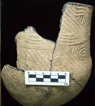
28 Figure 3. Whole pots still in possession of the collector. Poplar Springs Mound, Jackson County, FL. 15
29 Poplar Springs Mound Poplar Springs Mound and Village are located approximately 5.5 km east of the town of Marianna and 700 m south of the Blue Springs Reservoir (Figure 4). Currently the site is situated within the property boundaries of Indian Springs Golf and Country Club (Figure 5). The village is approximately situated within a wooded area, but the mound itself has been apparently obliterated and its location has been determined to be along the western edge of the 3 rd hole (Figure 6). Artifacts are still visible on the surface but highly fragmented. They show up in great numbers after a rainstorm. Poplar Springs Mound is located within the Marianna lowlands at an elevation of 46 m above sea level. The soil is a dark humus overlying gray sand. The 1973 site form on file in the Florida Master Site File stated that the flora were mixed and semideciduous forest. At the time of the 2003 USF visit, pine dominated the area next to the golf course; further into the wooded area were hardwoods. Surface survey on the golf course resulted in the recovery of small pieces of pottery and chert flakes. A variety of chert was represented in many different colors. Of interest was a whole, hafted biface, the basal fragment of a hafted biface, and a utilized blade-like flake (Figure 7). Five of the small pottery fragments were diagnostic (Figure 8). One was Swift Creek Complicated-Stamped, two were rims that were folded in a classic Weeden Island style, and two other fragments were rims with small narrow and deep notches. Gordon Willey (1949), who established the typology of prehistoric pottery of the Florida Gulf Coast in the late 1940s, found this kind of notching on Early and 16

30 Figure 4. Indian Springs Golf and Country Club, Marianna, Jackson County, FL. 17

31 Figure 5. Poplar Springs Village and Mound and nearby Middle Woodland sites. Mound and Village located along west side of hole 3 of the Indian Springs Golf Club. Site boundaries from Florida Division of Historic Resources. 18


32 Figure 6. Hole 3 of Indian Springs Golf and Country Club. Upper: Poplar Springs Mound estimated location, western edge of hole 3. View facing south. Lower: South end of hole 3, facing south (Anya Frashuer in background). 19


33 Figure 7. Lithic tools recovered from surface collection of Poplar Springs Mound. Left: hafted biface, Center: basal fragment of a hafted biface, Right: utilized blade-like flake. Figure 8. Ceramics recovered from surface collection of Poplar Springs Mound. Upper: Swift Creek Complicated-Stamped Center: Weeden Island folded rims Lower: Swift Creek notched rims possibly Franklin Plain. 20
34 Middle Woodland types such as Franklin Plain, Crooked River Complicated-Stamped or Santa Rosa Stamped (which is found mainly near Pensacola). This mound site was recorded in early 1973 then apparently lost to professional archaeology. The site form submitted in 1973 to the Florida Master Site File indicates that the site has experienced a great deal of looter activity. One such account states that one individual retrieved 14 whole pots from the east side of the mound. These pots are of particular interest, because they were perforated at the base or killed to use an archaeological term. They may be the ones owned by our donor and shown (mostly) in Figure 3. Bone fragments were also found in the backfill of pothunters in March of 1973, along with fragments of late Swift Creek and early Weeden Island pottery. According to the original site form, the archaeologist on site, Scott Nidy (1973), collected a few sherds. These artifacts are being curated by the Division of Historical Resources in Tallahassee, Florida. I visited Tallahassee to see these specimens; they are in keeping with the types in the donor s collection. The small sherd of Swift Creek pottery in Figure 9 shows a diamond pattern. Only a few pieces of pottery, plain, check-stamped and Swift Creek Complicated-Stamped, were recovered in 1973 along with a few flakes and a small piece of calcined bone, which were too small to identify (DHR Catalogue # ). This information seems to match the information obtained from the donor and from the pottery itself, and makes Poplar Springs Mound a highly probable candidate for the lost mound from which the collection came. 21

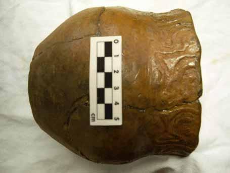
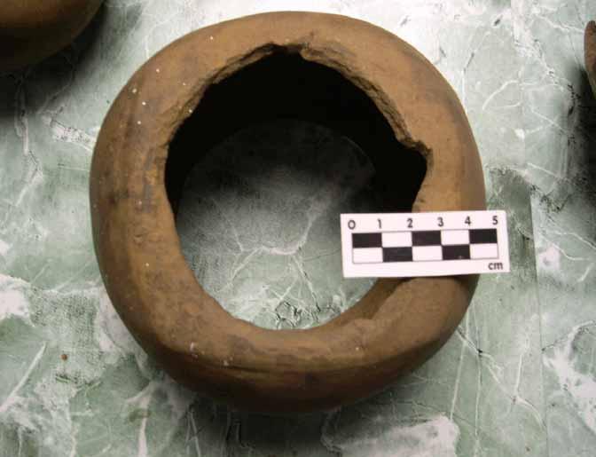
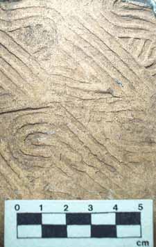
35 Figure 9. Swift Creek sherds recovered from Poplar Springs Mound by Scott Nidy (DHR) during the 1973 investigation. During the same 2003 trip, White obtained another box of pottery from the donor and photographed his whole perforated pots. These vessels were of plain design (Figure 10), Keith Incised (Figure 11), and stamped with a Swift Creek complicated pattern (Figure 12). They consisted of square-bottomed bowls (Figure 13), open bowls, flatbased, or pointed-bottom jars (Figure 14). The Swift Creek stamps were teardrop, circular, or diamond shaped (see Table 2 for a complete list of the pottery recovered, Table 3 for a list of pots still in the collector s possession, and Figure 3 for images of his whole vessels together at his home). 22


36 Figure 10. Undecorated vessels from Poplar Springs Mound still in possession of collector. Figure 11. Keith Incised vessel from Poplar Springs Mound still in possession of collector. 23

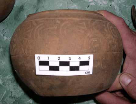
37 Figure 12. Swift Creek Complicated-Stamped vessels still in possession of collector. Figure 13. Undecorated, square-bottomed, ritually perforated vessel still in possession of collector. 24


38 Figure 14. Swift Creek Complicated-Stamped vessels with pointed bottoms still in possession of collector. 25
39 Pottery Type Table 2. Pottery from Donated Collection, Poplar Springs Mound Number of sherds Relative frequency by number Weight (g) Relative frequency by weight Swift Creek Complicated-Stamped Crooked River Complicated-Stamped Weeden Island Incised Weeden Island Red Weeden Island Plain Carrabelle Punctated - many sherds fit together into 2 or 3 pots check-stamped sand-tempered plain sand-tempered plain red painted grit-tempered plain grog-tempered plain grit and grog-tempered plain cord-marked indeterminate punctate - fingernail indeterminate incised indeterminate stamp Cool Branch Incised (Fort Walton type) shell-tempered plain - Mississippian TOTAL , Table 3. List of Whole Ceramic Vessels in Marianna Collector s Possession Decorated Plain Swift Creek Complicated-Stamped square flat bottom bowl with oval kill hole Swift Creek Complicated-Stamped flat base jar Teardrop Swift Creek Complicated-Stamped pointed bottom jar with kill hole Swift Creek Complicated-Stamped pointed bottom jar with notched rim Diamond Swift Creek Complicated-Stamped pointed base jar Keith Incised jar with folded rim Broken, nested circle Swift Creek Complicated- Stamped small bowl with kill hole Constricted-neck, flat-bottomed bowl with irregular kill hole Open bowl with small kill hole Open bowl with folded rim Open bowl with red slipped interior Burnished simple bowl Bowl with incision below rim, with kill hole 26
40 The Donated Pottery Upon returning to the lab from the 2003 field session, I began working on cataloguing both the 2000 and 2003 sets of donated pottery. Middle Woodland ceramic types are Swift Creek Complicated-Stamped, Weeden Island Red, Incised and Plain, and Carrabelle Punctated. There is also a very small amount of Mississippian pottery. The majority of the sherds are tempered with sand of varying grain size. Only a few sherds were tempered with grog (crushed pottery sherds). A few sand-tempered sherds had small amounts of grog and/or grit inclusions. One sherd was plain and tempered with shell, evident from large flat openings on the surfaces. This sherd was most likely a Mississippian type, and is considered anomalous here, or indicative of a later component. Many sherds exhibit smoothing and burnishing on one or both of the surfaces. One sherd had been brushed with what looks like a fine bristle instrument. Traces of red paint can be seen on 15 of the sand-tempered plain sherds. The Swift Creek pottery exhibited many different stamped designs. Teardrop and diamond shapes were found on some of the whole, killed pots still in the donor's possession (Figure 14), but many of the donated pots exhibited variations on the curvilinear swirling patterns (Figure 15). There was one Crooked River Complicated- Stamped sherd characterized by rectilinear zig-zagging complicated stamping and notched rims (Figure 16). Weeden Island pottery was not as abundant. One sherd had fine-tooled incisions ending in punctations that are indicative of Weeden Island Incised, while three Weeden Island Plain sherds were found, one which is known as Weeden 27

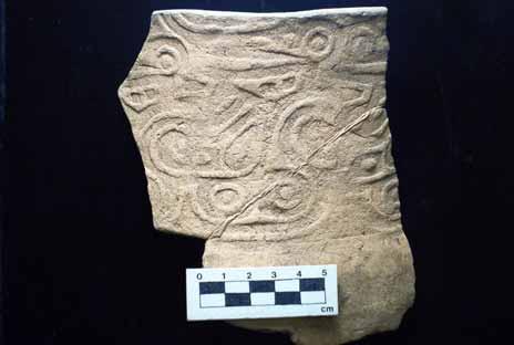
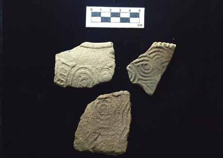
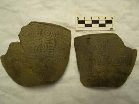
41 Figure 15. Swift Creek Complicated-Stamped pottery donated from Poplar Springs. Figure 16. Crooked River Complicated-Stamped sherd donated from Poplar Springs Mound. 28
42 Island Red for its red paint (Figure 17). Carrabelle Punctated sherds are represented with at least two types of tool marks, a squared-end tool and a tool that made a bean-shaped punctation (Figure 18). Including the pottery recovered in 2003, a large number of the sherds (25 percent by weight) are check-stamped and display various representations and sizes of checks (Table 2). Sand-tempered plain sherds (without paint) account for 48 percent of the sherds by weight. Since many of the Middle Woodland pots with decoration include plain sections, it is difficult to label these as sherds from plain-surfaced vessels. It is possible that they represent parts of the pots where there was no decoration, such as areas below the incised or stamped shoulder of a vessel (as can be seen on the lower portion of the Carrabelle pottery sherds in Figure 18). Without the whole pot, I cannot say that a majority of pots from this mound were without decoration. Two Mississippian ceramic types are represented by a Cool Branch Incised sherd and the shell-tempered sherd (Figure 19). This occurrence of later pottery types causes pause in this analysis. Remember that this is a pottery collection donated to us with a poorly documented past. It was unearthed over 30 years ago and has been in the possession of a descendant of the original collector. Its provenience is in question. However, there are some plausible reasons for the later types. It is possible that the collection, or part of it, does not come from Poplar Springs Mound at all or there was a small occupation of the mound in later times by a Fort Walton group and only a few sherds were collected. Most likely though, is that the Mississippian sherds are anomalous to the site. 29


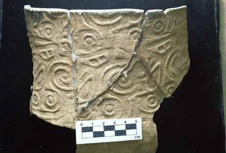
43 Figure 17. Weeden Island Pottery donated from Poplar Springs Mound. Upper Left: Weeden Island Incised; Upper Right: Weeden Island Zoned Red; Bottom: Weeden Island plain pottery with folded rims. Figure 18. Carrabelle Punctated Pottery donated from Poplar Springs Mound. Left: square punctation, Right: bean-shaped punctation. 30

 while Weeden Island makes up over 26 percent of the diagnostics (3 percent of the total collection).")
44 Figure 19. Mississippian Ceramics donated from Poplar Springs Mound: Cool Branch Incised sherd (left) and shell-tempered plain sherd (right). Discussion The near-absence of Weeden Island types diagnostic of later Middle Woodland suggests that these artifacts came from an earlier Middle Woodland mound. Swift Creek pottery makes up over 73 percent of the diagnostic pottery (8.5 percent of the total collection) while Weeden Island makes up over 26 percent of the diagnostics (3 percent of the total collection). While we currently have no way to date the mound and are depending on an old and not well-provenienced collection, this is still interesting and worth further study. Return visits to the site and testing to determine if there are intact subsurface deposits may provide us with material suitable for dating. Design comparison would provide a great deal of information regarding the exchange of Swift Creek paddle designs, and further work with this collection should include looking at the work done previously by Betty Broyles (1968), Rebecca Saunders (1986a, 1986b, 1994, 1998), and Frankie Snow (n.d., 1975, 1982, 1993, 1994, 1998; Snow and Stephenson 1993, 1998) with Swift Creek Complicated-Stamp designs. 31
45 The material collected from Poplar Springs Mound represents a long tradition of working with collectors to aid in the growth of the archaeological record and in answering questions of importance. Even though this site has been obviously destroyed, through heavy looting and bulldozing for recreational purposes, archaeologists are still able to study it, albeit with much information lost to progress. The scope of this study did not include subsurface testing, but coring or shovel testing may bring to light more information and help to add to the picture of ceremonial life in the upper Apalachicola Valley. Poplar Springs Mound and the information collected from the donated artifacts from the site are the stepping stone in the study of the Middle Woodland manifestations in the Apalachicola Valley. The next chapter follows with descriptions of the work done and artifacts collected from other Swift Creek and early Weeden Island mounds in the valley. Later chapters will then discuss the material culture of the mounds, how they are distributed along the valley and how Poplar Springs Mound fits in to the model proposed by Brose and Percy (1974) for Middle Woodland ceremonial activity in the Apalachicola Valley. 32
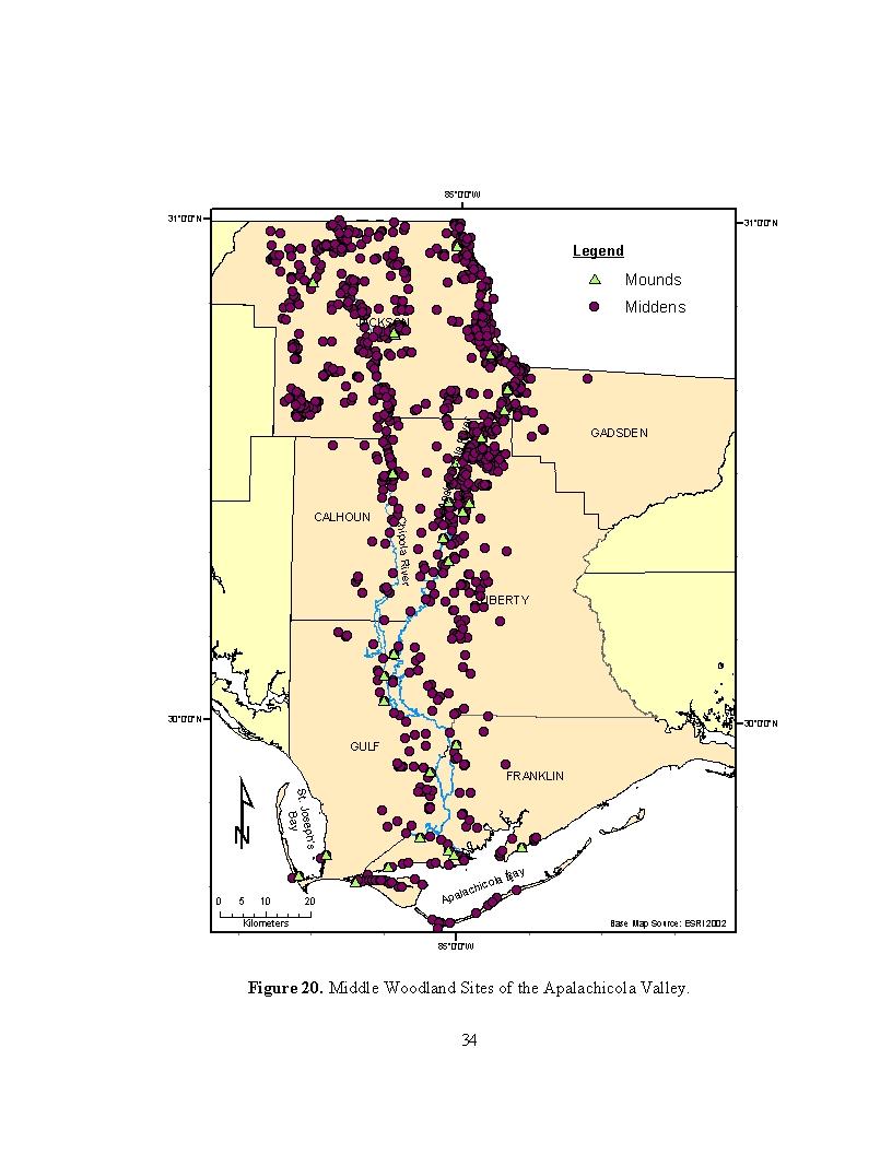
46 Chapter 3: Middle Woodland Mounds in the Apalachicola Valley Introduction Middle Woodland mounds of the Apalachicola Valley are distributed along the river, with the majority of them clustering around the coastal delta area or the upper river region of the Florida/Georgia/Alabama border (Figure 20 shows the distribution of mounds and domestic sites). Since data from Georgia or Alabama are not included in this study, it is important to note the potential bias in the distribution of any of the materials. The figure shows the stretch of the Chattahoochee River in Florida, which is only 40 km on the west side. Certain areas are also not well surveyed and present another bias, and so gaps in the distribution may only mean a lack of survey and not necessarily a lack of mounds or materials. Thirty mounds containing Middle Woodland components are spread along the Apalachicola, Chipola and lower Chattahoochee Rivers and along the Gulf Coast of this delta (Figure 21 and Table 4). The rest of this chapter is a discussion of each of these mounds, the history and artifacts recovered during surveys. Sites are ordered by county and site number. Site and related artifact photographs from my research are included with the appropriate site descriptions. These descriptive data are then organized and discussed in the following chapter. 33
47
48 85 0'0"W 31 0'0"N 8Ja '0"N 8Ja65 8Ja1388Ja93 JACKSON 8Ja2 8Ja1 8Gd1 Chipola River Apalachicola River 8Li5 8Ca2 8Ca114 8Li4 8Ca1 CALHOUN 8Li6 8Li7 GADSDEN LIBERTY 8Gu5 8Gu4 8Gu3 30 0'0"N ¹ St. Joseph's Bay GULF 8Gu2 8Fr10 8Gu10 8Gu1 8Gu41 8Fr8 8Fr12 8Fr15 8Fr19 8Fr '0"W FRANKLIN 8Fr118Fr1 Apalachicola Bay Kilometers Base Map Source: ESRI '0"N Figure 21. Middle Woodland Mounds of the Apalachicola Valley. 35
49 Table 4 Middle Woodland Mounds of the Apalachicola Valley Site Name (Site #) USGS Quad River Navigation Mile Nearest Water (Dist [m], Direction) Davis' Field (8Ca1) Blountstown 78 unnamed creek (200 SW) Elevation (m) Middle Woodland Components Other components 17 Swift Creek-early Weeden Island Location known? References Lower Creek or Seminole no Moore 1903, Willey 1949, DHR OK Landing (8Ca2) Altha East 88 Graves Creek (700 NE) Gaston Spivey (8Ca114) Clarksville 87 Chipola River (1340 W) Porter's Bar (8Fr1) Green Point 0 Apalachicola Bay (0 S) 18 Swift Creek-early Weeden Island 37 Swift Creek-early Weeden Island 2 Swift Creek-early Weeden Island Late Archaic, Deptford, Fort Walton, Historic, Santa Rosa no Moore 1918, Willey 1949 yes White and Trauner 1987 yes Moore 1902, Willey 1949, Jones 1993, White 1996 Brickyard Creek (8Fr8) Forbes Island 21 Brickyard Creek (30 NW) 3 Swift Creek-early Weeden Island no Moore 1903, Willey 1949, DHR Eleven Mile Point (8Fr10) Indian Pass 0 St. Vincent Sound (0 S) 3 Swift Creek-early Weeden Island Deptford, Fort Walton, late Weeden Island yes Moore 1902, Willey 1949, White 1999 Green Point (8Fr11) Green Point 0 Apalachicola Bay (0 S) Huckleberry Landing (8Fr12) Jackson River 5 Jackson River (30 N) Pierce Mounds (8Fr14) West Pass 1 Turtle Harbor (200 NE) 1 Swift Creek-early Weeden Island 1 Swift Creek-early Weeden Island 3 Swift Creek-early Weeden Island no Moore 1902, Willey 1949 Santa Rosa yes Moore 1902, Willey 1949, Glowacki and White 2005, USF Lab Deptford, Santa Rosa, Fort Walton yes Moore 1902, Willey 1949, Carr 1975, USF Lab Jackson Mound GV* (8Fr15) West Pass 1 Scipio Creek (300 ENE) * - GV stands for general vicinity (as used by Florida Master Site File when location is not verified). 2 Swift Creek-early Weeden Island Santa Rosa, Fort Walton probably Moore 1902, Willey 1949
50 Table 4 (Continued) Middle Woodland Mounds of the Apalachicola Valley River Navigation Mile Nearest Water (Dist [m], Direction) Site Name USGS Quad Cool Springs Mound (8Fr19) West Pass 1 Turtle Harbor (200 NE) Aspalaga Landing Mound (8Gd1) Rock Bluff 99 Apalachicola River (570 W) Mound Near Indian Pass Point (8Gu1) Indian Pass 0 Indian Lagoon (400 N) Gotier Hammock (8Gu2) Cape San Blas 0 St. Joseph Bay (380 W) Elevation (m) Middle Woodland Components Other components 3 Swift Creek-early Weeden Island 61 Swift Creek-early Weeden Island Location known? References Fort Walton probably part of Fr14 and Fr21 Fort Walton? yes Moore 1903, White 1996, USF Lab 3 early Weeden Island yes Moore 1902, Willey 1949, White 1999, USF lab 2 Swift Creek-early Weeden Island yes Moore 1902, Willey 1949, White 2005, USF Burgess Landing (8Gu3) Wewahitchka 31 Burgess Creek (10 E) 6 Swift Creek-early Weeden Island Isabel Landing (8Gu4) Wewahitchka 36 Whites River (0 E) 6 Swift Creek-early Weeden Island Lab Deptford yes Moore 1903, Willey 1949, USF Lab no Moore 1903, Willey 1949, White 1999 Chipola Cutoff (8Gu5) Dead Lake 42 Chipola Cutoff (0 W) Richardson's Hammock (8Gu10) Cape San Blas 0 St. Joseph Bay (0 N) Howard Creek Mound (8Gu41) Forbes Island 17 Howard Creek (225 E) * - GV stands for general vicinity (as used by Florida Master Site File when location is not verified). 7 Swift Creek-early Weeden Island 1 Swift Creek-early Weeden Island Fort Walton, Protohistoric yes Moore 1903, Willey 1949, Henefield and White 1986, White 1999 Fort Walton, Lamar yes DHR, White et al 2002, USF Lab 4 Swift Creek Late Archaic? yes Henefield and White 1986, White 1992
51 Location known? References no Moore 1903, Willey 1949, Percy 1976 yes Moore 1903, Bullen 1959 Table 4 (Continued) Middle Woodland Mounds of the Apalachicola Valley River Navigation Mile Nearest Water (Dist [m], Direction) Site Name USGS Quad Sampson's Landing (8Ja1) Sneads 103 Apalachicola River (360 SE) Elevation (m) Middle Woodland Components Other components 31 Swift Creek-early Weeden Island Moore's Mound near Kemp's Landing (8Ja2) Sneads 3 Chatahoochee under Lake Seminole 23 Swift Creek-early Weeden Island Waddell's Mill Pond Site (8Ja65) Sills 122 Waddell's Mill Pond (30 S) Watson's Field GV* (8Ja93) Marianna 7 Chatahoochee Merritts Millpond (880 N) 30 Swift Creek-early Weeden Island 40 Swift Creek-early Weeden Island Late Archaic, Deptford?, Fort Walton yes Gardner 1966, DHR Archaic, late Weeden Island? no DHR Poplar Springs Mound (8Ja138) Marianna 7 Chatahoochee Patrick Pond (8Ja325) Bascom 21 Chatahoochee Merritts Millpond (540 N) unnamed oxbow lake (20 W) 30 Swift Creek-early Weeden Island 30 Swift Creek-early Weeden Island Fort Walton 1966, Nidy 1973, USF Lab yes DHR, Gardner Archaic?, Deptford possibly DHR Mound Below Bristol (8Li3) Bristol 77 unnamed creek (210 SE) Bristol Mound (8Li4) Bristol 81 Apalachicola River (530 NNW) Rock Bluff Landing (8Li5) Rock Bluff 93 Trubutary of Rock Creek (460 SE) Michaux Log Landing (8Li6) Estiffanulga 70 Apalachicola River (60 W) 47 Swift Creek Santa Rosa, Indeterminate checkstamped? 40 Swift Creek-early Weeden Island 61 Swift Creek-early Weeden Island 12 Swift Creek-early Weeden Island no Moore 1903, Willey 1949 late Weeden Island no Moore 1903, Willey 1949 Late Archaic yes Moore 1918, Willey 1949, DHR yes Moore 1918, Willey 1949, USF Lab Estiffanulga GV* (8Li7) Estiffanulga 65 Outside Lake (10 S) 9 Swift Creek no Moore 1903, Willey 1949 * - GV stands for general vicinity (as used by Florida Master Site File when location is not verified).
52 The Middle Woodland Mounds Davis Field, 8Ca1. Davis Field was located during Moore s Apalachicola River expedition in 1903 on a tributary stream of the Apalachicola. This mound composed of clay was 21 m in diameter and over 1 m high. There was a smaller interior mound that was built up over a sub-floor pit. Ceramics included late variety Swift Creek Complicated-Stamped, Weeden Island Plain, Weeden Island Incised and undiagnostic red painted sherds. The majority of vessels were ritually perforated; some with evidence of perforation during the formation process and some that were perforated after the final firing. Non-ceramic artifacts included conch shell cups and sheet-mica fragments. Twenty-six burials were encountered, including primary flexed and secondary bundle and single skull (Moore 1903: ; Willey 1949: ). A visit to the Division of Historical Resources (DHR) in Tallahassee Florida resulted in our locating more Swift Creek Complicated-Stamped sherds (Figure 22). This mound was not relocated. OK Landing, 8Ca2. OK Landing was discovered during Moore s re-visitation of the northwestern Florida coast in This mound was over 10 m in diameter and one meter high. Ceramics included Swift Creek Complicated-Stamped and undiagnostic plain, incised and check-stamped sherds all interred together in a single mass deposit and ritually perforated. The only other artifact was a lump of galena. There were only two 39
 or single skull (Moore 1918:554; Willey 1949:252). The mound was not relocated. Gaston Spivey, 8Ca114.")
53 Figure 22. Swift Creek Complicated-Stamped pottery sherds from Davis Field Mound. Pottery curated at the DHR. Photo courtesy of Nancy White. burials, both secondary types, but it is unknown whether they were bundle (groups of bones) or single skull (Moore 1918:554; Willey 1949:252). The mound was not relocated. Gaston Spivey, 8Ca114. The Gaston Spivey Mound was located through a local informant, Gaston Spivey, who owns the land and house built on it. He contacted White who visited the site during the 1987 survey of the Chipola River (White and Trauner 1987). The mound had been heavily looted and severely damaged due to construction of a nearby road and the house. A one-meter-square test unit was dug. Pottery included Swift Creek Complicated-Stamped and undiagnostic check-stamped and plain sherds. Non-ceramic artifacts were a possible Pinellas Point, undiagnostic projectile points and a grinding stone fragment. 40
54 Porter s Bar, 8Fr1. Porter s Bar consists of a burial mound and shell midden situated on St George s Sound approximately 5 km east of East Point. Moore discovered this site during his 1902 Northwest Florida Coast expedition and at the time of his visit was approximately 400 m back from the beach. He found the mound in a partially destroyed state, 18 by 24 m at the base and 3 m high. It was made up of layers of white, yellow and blackened sand over a base layer of oyster shell. Ceramics include early and late varieties of Swift Creek Complicated-Stamped, Alligator Bayou Stamped, Weeden Island Plain and Incised, a human-effigy vessel form (not illustrated) and undiagnostic check-stamped and red-painted sherds. Vessels were ritually perforated. An elbow-shaped pottery pipe was also recovered. Non-ceramic artifacts include projectile points, celts, hammerstones, a stone pendant, shell pendants, cups and tools, cut animal jaws, hematite ore, galena, sheet mica, bitumen, cooper, and a carved kaolin baton. Sixty-eight burials were found on, near or in the shell base. Burials included primary flexed and semiflexed, secondary bundle and single skull, and a single deposit of calcined bones (Moore 1902: ; Willey 1949: ). Calvin Jones surveyed this site during the early 1990s. He excavated Late Archaic burials eroding out of the midden on the shore and noted heavy looting occurring at the mound. In 1996, White relocated the mound and surveyed the area (Figures 23-25). Construction for residential property was occurring nearby and so shovel testing, surface collection and cleaning of pothole profiles was conducted (White 1996). Because of this site s accessibility to the beach, many more unusual materials were recovered. 41


55 Figure 23. Shell artifacts from Porter s Bar in USF collections. Photos courtesy of Eric Eyles. Figure 24. Mounds at Porter s Bar. Left: Looting at Porter s Bar. Anya Frashuer at left. Right: Western mound at Porter s Bar. Anya Frashuer at left and Tony White atop mound. Photos courtesy of Nancy White. Figure 25. Hematite nodule from Porter s Bar in USF collections. 42
56 Brickyard Creek, 8Fr8. Moore discovered Brickyard Creek mound during his 1903 Apalachicola River expedition. It had already been disturbed by looting and was over 10 m in diameter and over one meter high at the time of his visit. The ceramics he collected included Swift Creek Complicated-Stamped, Weeden Island Plain, a Weeden Island or Fort Walton effigy lug, and undiagnostic incised, punctated and check-stamped sherds. Vessels were ritually perforated. Non-ceramic artifacts included projectile points, scrapers, hammerstones, hones, bone awls, conch columella tools, and fragments of sheet mica. Human bone was also found, but it was so badly decayed that the amount or burial style was indeterminate (Moore 1903: ; Willey 1949:273). In the Fall of 1999, a USF crew was joined by United States Forest Service archaeologists Andrea Repp and James Halpern to help locate the mound. Twenty years before, the previous Forest Service archaeologist had relocated the mound and this information was used to return to the area. No mound was visible and testing resulted in no artifacts found (White 1999). Eleven Mile Point, 8Fr10. Eleven Mile Point is a midden and burial mound located over 17 km west of the city of Apalachicola on St. Vincent Sound. The midden is located on the shore while the mound is located several meters inland. Moore found and excavated the mound during his 1902 Northwest Florida coast expedition. The mound was 15 m in diameter and almost one meter high. Ceramics included early variety Swift Creek Complicated-Stamped, Alligator Bayou Stamped, Weeden Island Plain and undiagnostic incised. Vessels were ritually perforated. Non-ceramic artifacts were not mentioned while 43
57 burials were mentioned but number or types not recorded (Moore 1902: ; Willey 1949: ). Willey (1949) visited the site during his 1940 survey, relocated the midden but was unable to find the mound. White returned in 1996 to see the mound in a cleared area underneath a house. The owner had a large collection of artifacts, which she graciously allowed to be photographed. Green Point, 8Fr11. Moore discovered Green Point during his 1902 Northwest Florida coast expedition. The mound is located just east of Porter s Bar. At the time of its discovery, it had been heavily disturbed by cultivation and was determined to be 19 m in diameter and 1 to 2 m high. It was constructed of sand with inclusions of shell and blackened organic material interspersed. Ceramics included early variety Swift Creek Complicated-Stamped, Franklin Plain, Crystal River Zoned Red, and undiagnostic plain, incised and fabric-marked sherds. Vessels were ritually perforated and there was mention of tetrapod bases and notching of rims. Two pipes were also discovered; one monitor pipe of either stone or pottery and one pottery pipe of unrecorded form. Non-ceramic artifacts included projectile points, lances, celts, hones, smoothing stones, hammerstones, shell cups, gouges, pendants, and disks. A large number of burials, 80 in all, were of primary flexed and semiflexed and secondary bundle and single skull types (Moore 1902: ; Willey 1949: ). White and crew re-attempted to relocate this mound several times without success. 44
58 Huckleberry Landing, 8Fr12. Huckleberry Landing is a collection of shell middens and a mound along the coast of the Jackson River. Moore found this site in 1902 during his Northwest Florida coast travels. The mound consisted of sand with inclusions of either sand or clay dotted throughout. The mound stands 2 m high with a base diameter of 12 m east to west and 16 m north to south. Ceramics included early variety Swift Creek Complicated Stamped, Weeden Island Plain and undiagnostic check-stamped sherds. Vessels were ritually perforated. Two pottery pipes were also found; one monitor style and the other elbow-shaped. Non-ceramic artifacts included celts, hones, pebble hammers, stone pendants, sheet mica, rattles made of turtle shell and pottery ear spools plated with copper. Thirty-four burials were spread out all throughout the mound. Of these burials, two-thirds are secondary burials of the bundle and single skull type and one-third are primary flexed burials. In some of the burials, Moore documented pathology on the bones, but there was no mention of the type or description of the bone deformation (Moore 1902: ; Willey 1949: ). White and USF student archaeologists visited Huckleberry Landing several times in the 1980s (Figure 26-29). In 2005, the Conservation and Recreational Lands (CARL) team, led by Mary Glowacki, returned to the area to document the site, as the state had purchased the land. They found was a shell midden of Rangia cuneata and a mostly-sand mound with some shell. It was bordered to the north by the Jackson River and to the east and west by marshes. The condition of the mound had been greatly impacted since Moore s visit. The CARL team found a doughnut-shaped mound only 1.5 m high (as 45


59 opposed to Moore s 2 m). At the mound they found Deptford Plain, Wakulla Check- Stamped, Weeden Island Plain, and Lake Jackson Incised (Glowacki and White 2005). Nancy White, Amber Yuellig and I revisited Huckleberry Landing in June of The water level of Jackson River was high and the area was very swampy with inundated areas. The mound was still intact with the doughnut s crater still visible on the east side of the mound, most likely from Moore s excavation. Swift Creek pottery dotted the surface of the east side of the mound and the midden. Figure 26. Shell scoop from Huckleberry Landing. Photo courtesy of Eric Eyles. Figure 27. Quartz pebble from Huckleberry Landing. USF collections. Figure 28. Hematite nodule from Huckleberry Landing mound. USF collections. 46


 and Willey (1949:278-282).")
60 Figure 29. Swift Creek Complicated-Stamped pottery from Huckleberry Landing mound. USF collections. Pierce Mounds, 8Fr14. Pierce Mounds is a multi-mound, multi-component site near the coast on the edge of the city of Apalachicola. This complex includes many mounds of the Pierce site and other sites, such as Jackson Mound and Cool Springs Mounds discussed later. For the sake of this research, only Middle Woodland mounds of the Pierce complex will be discussed. For information about the rest of the site, refer to Moore (1902: ) and Willey (1949: ). Pierce Mounds includes the northern portion of the city s cemetery. The property on which many of the Pierce Mounds are located is under controversy. This property is 47
61 slated to be divided and sold for residential purposes. There has also been a considerable amount of damage done to all the mounds from ATV traffic and heavy looting. Moore discovered Pierce Mounds (including Jackson and Cool Springs mounds) during his 1902 Northwest Florida Coast expedition. Mound A is located on the southwestern side of the site. It is a yellow sand and shell flat topped mound over 2 m high, a base of 29 m east to west and 23 m north to south, and a summit of 12 by 10 m. Ceramics included Swift Creek Complicated-Stamped, Santa Rosa Stamped, Crystal River Zoned Red, Pierce Zoned Red, and Weeden Island Incised along with a Weeden Island multiple orifice vessel and grubworm effigy. Vessels were ritually perforated. Undiagnostic plain and cord-marked sherds along with a ceramic monitor pipe, small vessels, tetrapod supports and notched rims were mentioned. Non-ceramic artifacts include projectile points and chisels, celts, stone plummets, pearls, a copper tube and ear spools platted with silver, shell cups, gougelike columella tools and beads, a bison bone gorget, and wolf and panther teeth. This is the largest burial site of the Pierce group. During his excavations, Moore uncovered and documented 99 burials. A majority of the primary burials were flexed skeletons and only a few were extended (a rarity in the valley). Secondary burials included bundle and single skull types, with one mass deposit of bones. The mound now stands in an overgrown parcel, 1.5 m high and 26 by 20 m at its base. There are ATV tracks running up its side and looters holes in the sides and at the top (Figure 30). Human bone fragments found on the top of the mound during one visit were sent to the state collections in Tallahassee. USF collections include undiagnostic 48


62 check-stamped sherds and shell tools from the mound. Artifacts collected from visits over many years are still in the processes of documentation and will be available in the future. Figure 30. Pierce Mound A. Left: North side of Mound A with looter s holes. Right: Southeastern side of Mound A with ATV track. Moore s Mound C is a smaller burial mound located between Mounds A and B (which is at the north center of the property adjacent to railroad tracks). The mound consisted of sand over a shell base and was originally 2 m high and 27.5 m east to west by 22.5 m north to south. Moore dug a 10.5 m trench, 4.5 m wide, through the mound. He found Swift Creek Complicated-Stamped, undiagnostic check-stamped and punctated sherds, and pottery beads. Three primary flexed burials were encountered. Visits from the USF crew documented that the mound was heavily disturbed just like Mound A. It is over one meter high and approximately 33.5 m square, made up of gray sand with an oyster shell base overlying yellow sand. In June of 2004, the mound had recently been looted with one 4 m trench and another shorter in length. ATV tracks covered the mound and adjacent area (Figure 31). 49

63 Figure 31. Pierce Mound C with ATV track up the center. View facing north. Photo courtesy of Nancy White. Jackson Mound, 8Fr15. Jackson Mound is located over 3 km northwest of the city of Apalachicola. Moore discovered the mound in 1902 during his Northwest Florida expedition. It was probably part of the entire Pierce group in prehistory. The mound measures almost 3 m high and 22 by 20 m at its base. Ceramics included early and late varieties of Swift Creek Complicated-Stamped, Alligator Bayou Stamped, a vessel of Weeden Island Plain style, and undiagnostic plain, and incised sherds. Vessels were ritually perforated. Pottery and steatite pipes were found, exhibiting notching rims, block pattern and elbow-style. Non-ceramic artifacts included projectile points, celts, hones, smoothing stones, hammerstones, stone beads and plummets, a quartz plummet, hematite ore, galena, and a fragment of copper. It contained 26 burials, most of them badly decayed. Burials were identified as secondary bundle and single skull along with a single cremation, but no other information was possible due to the degradation of the remains (Moore 1902: ; Willey 1949: ). 50
64 Cool Springs Mound, 8Fr19. Moore mentioned Cool Springs Mound in his Northwest Florida coast notes from 1902 as being located west of the outskirts of the city of Apalachicola. This mound was probably originally part of the Pierce Mound group. It was heavily looted when Moore located it and reported it as being over 2 m high and 27.5 m in diameter. He dug about two-thirds of this sand mound and found Swift Creek Complicated-Stamped, a frog effigy, animal rim effigies, and undiagnostic check-stamp, incised and punctated sherds. Non-ceramic artifacts included a projectile point, celt and mica. Upwards of nine burials were found of primary flexed, semi-flexed and extended types and secondary bundle and single skull types (Moore 1902:216; Willey 1949:284). White and crew have not yet been able to relocate this site. Aspalaga Landing Mound, 8Gd1. The Aspalaga Landing site was located by Moore in 1903 during his Apalachicola River expedition. The site consists of one shell midden, two domicile sand mounds, and one sand burial mound situated high atop bluffs in the Torreya Ravines. For this research, only the burial mound is discussed. The burial mound is oblong in shape, 27.5 m in diameter and was reported as 2 to 3 m high. Ceramics included an early variety of Swift Creek Complicated-Stamped, St. Andrews Complicated-Stamped, Crystal River Incised, Weeden Island Plain, and undiagnostic redpainted sherds. Tetrapodal supports and notched rims were mentioned. Non-ceramic artifacts included projectile and lance points, celts, hammerstones, a stone disk, shell cups and beads, mica spear-point form and sheet-mica fragments, and hematite ore. 51
65 Moore found 54 burials of primary flexed and secondary bundle and single skull types (Moore 1903: ; Willey 1949: ). The state tried to buy this mound site for years with little success; after the construction of I-10 in the 1970s, it became heavily looted as it was more easily accessible and better known to collectors. White and crew (White 1996) visited Aspalaga Landing mound as part of a 1995 survey of the impacts of record flooding in the valley. They found a severely damaged mound and almost non-existent midden damaged by clear-cutting for timber and extensive looting. Ceramics recovered included Weeden Island Incised, Weeden Island Punctated, Carrabelle Punctated, and undiagnostic cordmarked, punctated, incised, and fabric-marked. Non-ceramic artifacts include quartz flakes, limestone fragments and glass. Mound Near Indian Pass Point, 8Gu1. Mound Near Indian Pass Point was located during Moore s 1902 Northwest Florida Coast expedition. The mound is composed of both sand and shell, was irregular in shape, 15 m in diameter and one meter high. This mound did not have any Swift Creek pottery (the only one of its kind in this study) but did have Weeden Island Incised and Indian Pass Incised along with undiagnostic plain and checkstamped sherds. This suggests that this mound was in use at a time later in the Middle Woodland. This was deposited in a primary cache and smaller caches and the pottery exhibited ritual perforation. Other artifacts include projectile points, celts, honestones, shell cups, shell chisel, and hematite. This is a small burial mound with an unknown number of bundle burials. The most important aspect of this burial mound is its numerous 52
66 skulls with marked front and rear cranial flattening that is found no where else in the valley (Moore 1902: ). Gordon Willey (1949: ) relocated the mound in 1940 with Moore s original excavation cavity still visible. The mound was located among sand dunes dotted with pine and oak. Within the cavity Willey found a few pieces of Weeden Island Plain pottery. The first attempt by USF crew to locate the mound (White 1999) used pedestrian survey of the sand dunes and residential yards in the area of Moore s description. Nothing was found but the conclusion was that the mound must have been underneath one of the homes. In the Fall of 2003, a USF team consisting of Nancy White, Amber Yuellig, Chris Smith, Karen Mayo and myself were led by a local informant to relocate the mound. Currently the mound is situated partially under a beach home on the coastal beach side of Indian Pass Point (Figure 32). Undiagnostic plain sherds and cut shell pieces were found on the northern side of the mound (Figure 33). Artifacts were found to the north of the road and spread 150 m west (Figure 34). This is most likely due to the building of the road and destruction of the northern part of the mound. 53


67 Figure 32. Mound Near Indian Pass Point located within the front yard of a residential property. View facing south. Photo courtesy of Nancy White. Figure 33. Shell tools collected from the surface of Mound Near Indian Pass. USF collections. Photos courtesy of Eric Eyles. Figure 34. Scatter of shell and modern refuse northwest of mound. Amber Yuellig in foreground. 54
68 Gotier Hammock, 8Gu2. Gotier Hammock was discovered during Moore s 1902 Northwest Florida Coast expedition. This mound is located along the coast on the eastern edge of St. Joseph s Bay, a high salinity bay well known for marine resources such as scallops and for easy access to sea turtles during winter months. The mound, composed of dark sand, was already heavily looted during Moore s visit. He determined that the mound was 18 m in diameter and 1.5 m high. Most of the pottery deposits were removed during looting. Only a few vessels were identified at the mound, a late variety Swift Creek Complicated vessel with a decorated neck and plain base, other Swift Creek Complicated-Stamped, St. Andrews Stamped and Weeden Island Incised sherds and undiagnostic plain and red painted sherds. Some of the vessels showed ritual perforations. The St. Andrews Complicated-Stamped sherd illustrated in Moore (1902:210) is similar in pattern to another St. Andrews sherd found at Watson s Field (central Jackson County), which is part of the Florida Museum of Natural History s collection (FLMNH Catalogue # ). Only a few bundle burials were located by Moore, scattered through the mound and below the base of the mound (Moore 1902: ; Willey 1949: ). During the Fall of 2003, Nancy White, Amber Yuellig, Chris Smith, Karen Mayo and I were led by a local informant to the location of Gotier Hammock (Figure 35). He had collected from the site as a child and had in his possession cut pieces of sheet mica (Figure 36). The mound had been flattened and its associated village damaged by the biggest land developer in Florida, the St. Joe Company. Swift Creek Complicated- Stamped, Weeden Island Incised, Keith Incised, Carrabelle Incised, Indian Pass Incised 55
.")

69 and undiagnostic plain, cord-marked, and stamped sherds were found on the surface of the mound area and the dirt road leading up to it (Figure 37). Non-ceramic artifacts included large gastropod shell awls, Busycon shell tools and columella awls (White 2005:74-83). Figure 35. Site of Gotier Hammock mound. Mound on right. Anya Frashuer in background, Karen Mayo in center and local informant in foreground. Photo courtesy of Nancy White. Figure 36. Cut mica from Gotier Hammock in private collection. 56


70 Figure 37. Artifacts collected from the surface of Gotier Hammock in USF collections. Photos courtesy of Nancy White. Burgess Landing, 8Gu3. Burgess Landing was located during Moore s Apalachicola River expedition in 1903 off a tributary to the Chipola River. This mound, composed of clayey sand, was 15 m in diameter and 1.5 m high. The pottery was found together within a single cache and includes Swift Creek Complicated-Stamped, Weeden Island Plain, undiagnostic incised and red painted sherds. The vessels were ritually perforated. Projectile points, celts, honestones, and sheet mica was also found but scattered through the mound and not within the pottery mortuary cache. Twelve secondary bundle and single skull burials were located by Moore (1903: ; Willey 1949:254). During the summer of 2004, our local informant joined the USF crew to help relocate Burgess Landing, a site he visited as a child. We were able to locate remnants of the mound alongside a new paved road and ditch to the north where its original location was shown on Moore s map (Figure 38). Artifacts included fragments of undiagnostic plain pottery. 57

71 Figure 38. Location of Burgess Landing. View facing west. Photo courtesy of Nancy White. Isabel Landing, 8Gu4. Isabel Landing, located on the Chipola River, was discovered by Moore during his 1903 Apalachicola River expedition. This mound was 15 m in diameter and 1.5 m high. Pottery was grouped into one cache and included Swift Creek Complicated-Stamped, a Weeden Island-style effigy, undiagnostic check-stamped and punctated pottery, and a vessel whose description (without illustration) indicates the type St. Andrews Complicated-Stamped. Moore s notes indicate he found two secondary burials of unknown type (Moore 1903:445; Willey 1949:254). White (1999) attempted to relocate the mound using pedestrian and boat survey and shovel testing, with no success. A return visit in 2004 with a local informant resulted in the same. We were unable to relocate this mound as there was no evidence of the 58
72 mound itself or related artifacts in the vicinity of the place on Moore s map. This mound is next to the Chipola River and within the property boundary of a marina. It is quite possible that the construction of the marina is the reason that there is no mound today. Or else the original location of the landing changed as the river meanders changed. Chipola Cutoff, 8Gu5. The Chipola Cutoff Mound is located on the Chipola Cutoff, a natural channel that connects the Chipola River to the Apalachicola River. The mound was made up of sand with some clay, and measured almost 14 m in diameter and 1.5 m high. It was discovered by Moore in 1903 during his Apalachicola River expedition and was previously looted. What was left of the mound still amounted to a large collection of Middle Woodland and Fort Walton (including contact period) artifacts and a significant amount of data from multiple burials. Middle Woodland ceramics included late variety Swift Creek Complicated-Stamped, Weeden Island Plain and Weeden Island Incised. Most vessels were ritually perforated with one example of perforation prior to firing. Non-ceramic artifacts included stone celts and hones, shell gouges, chisels, beads and hairpins, bone awls and hairpins, and hematite ore. Burials were found at 42 places in the mound or on its base. Burials are of primary flexed and semiflexed and secondary bundle and single skull. One skull had an inverted vessel over it (Moore 1903: ; Willey: ). The site of the mound was relocated by the USF crew with some difficulty. The first attempt was in 1985 (Henefield and White 1986) and a revisit occurred in July of 1999 (White 1999). Pedestrian survey turned up no mound or artifacts. A visit to the 59

73 Wewahitchka Public Library in 2003 brought us to Mr. Tom Semmes and his collection of artifacts from the mound and a map of its location. The majority of his collection is of Fort Walton sherds and one effigy. He was able to take us to the location of the mound and tell us about his days as a child collecting there. The mound was nowhere to be seen and no artifacts were in evidence on the surface (Figure 39). At this time the verdict was that the mound was under the surface of the cut-off waters. A return visit a year later and a conversation with a resident of a nearby house determined that the dredging of the cutoff and changing path of the water had destroyed the mound. Figure 39. Location of Chipola Cutoff. Cassandra Rae Harper in background. Rise of land is not the mound but new berm created apparently by piling up dredging deposits. 60
 was hired by the former owner of the area to conduct a survey of the whole site.")
74 Richardson s Hammock, 8Gu10. Richardson s Hammock is a multi-component, multimound/midden site that is spread along the northern portion of a small peninsula off St. Joseph Peninsula. The Middle Woodland mound is located at the northern-most part of the site. It was heavily looted beginning in the early 1980s. Around the same time, Wayne Childers (n.d.) was hired by the former owner of the area to conduct a survey of the whole site. The mound and midden produced Weeden Island Incised and Swift Creek Complicated-Stamped ceramics (White et al. 2002). No USF investigations were conducted at this mound, only mapping of its location (Figure 40) and testing in the midden area. Figure 40. Burial mound at Richardson s Hammock. Elan Marsh (with insect netting over her head) in background atop center of mound. 61
75 Howard Creek Mound, 8Gu41. In the lower part of the valley, Howard Creek Mound is situated behind a home in the small fishcamp of Howard Creek. This mound was recorded by Susan Henefield and Nancy White (1986:55-56, 123; White 1992) during the 1985 survey of the middle and lower portions of the Apalachicola Valley. At this time, the mound was 20 m in diameter and almost a meter high. They located the mound with the help of a local resident whose collection included many Swift Creek Complicated- Stamped pots (ritually perforated), plain sherds, as well as bone tools, mica, and copper disks (Figure 41). Unfortunately, during a later survey, he had to sell his artifacts to pay his bar bills, and the collection thus disappeared after he died. A crew of USF students led by White returned in the summer of 2004 to relocate the mound. We found it behind a mobile home with the east side of the mound modified for the construction of a fish cleaning shack on it. No artifacts were found on the surface and only a small handfull of fresh-water shell was located at the base of the south side (Figure 42). The lack of Weeden Island pottery makes this one of three sites that are probably early Middle Woodland sites. It is also the only site without Weeden Island pottery that also has exotic materials. 62


76 Figure 41. Artifacts from Howard Creek Mound. Upper left: Bone fragments. Upper right: cut mica sheet. Bottom: copper earspools. Photo courtesy of Nancy White. Figure 42. Howard Creek Mound. Left: View from the west. Right: East side of mound with fish cleaning shack. 63
77 Sampson s Landing, 8Ja1. Sampson s Landing was first discovered by Moore during his 1903 Apalachicola River expedition. This was a sand and gravel mound approximately 14 m in diameter and almost 1.5 m high. Ceramic artifacts included late variety Swift Creek Complicated-Stamped, Weeden Island Incised (?), and undiagnostic plain and check-stamped sherds. Numerous vessels were ritually perforated. Stone celts, shell cups and fragments of sheet mica were also encountered. Skeletal remains included 47 burials of flexed primary burials and bundle and single skull secondary burials. Three of the flexed primary burials were found below slabs of limerock (Moore 1903: ; Willey 1949: ). Percy (1976: ) investigated the associated midden, Scholz Steam Plant Site (8Ja104), and interviewed a local collector, Mr. Burgess. At the time of the visit, Burgess was unable to relocate the mound but allowed a vessel from his collection to be photographed. We were not able to relocate this mound. Moore s Mound Near Kemp s Landing, 8Ja2. Moore s Mound Near Kemp s Landing was located during his Apalachicola River expedition in 1903 off a tributary to the Apalachicola. This mound, composed of clay, was 10 m in diameter and almost 1.5 m high. Ceramics included late variety Swift Creek Complicated-Stamped, Weeden Island Plain, Weeden Island Incised, Indian Pass Incised and undiagnostic plain and checkstamped. The pottery was ritually perforated. A single burial consisting of a single skull and a cache of mortuary pottery were found. No other artifact types were present (Moore 1903: ; Willey 1949:251). 64
78 Ripley Bullen (1958: ) attempted to find the mound during survey but wasn t able to relocate it until 1953, when the area was cleared for timber and construction of the Jim Woodruff Reservoir, later known as Lake Seminole. The process of clearing the land caused a smearing of the mound from the west to the east. Bullen dug a trench in the undisturbed north portion of what was left of the mound. He described a clay mound situated on a slight natural rise, but his estimations of the mound size (one meter high and 18 m in diameter) were lower and wider than Moore s observations. Bullen also saw numerous human bone fragments dug up by the land clearing, a difference from Moore s account of a single skull fragment. Pottery found during this survey included early and late varieties of Swift Creek Complicated-Stamped, Weeden Island Plain and Punctated, Carrabelle Punctated, Wakulla and Gulf Check-Stamped, tetrapod bases, and undiagnostic check-stamped, stamped, and red-painted. The mound is now submerged under the lake. Waddell s Mill Pond Site, 8Ja65. Gardner (1966) first discovered Waddell s Mill Pond site in the early 1960s. Then in the 1970s it was tested by the late Calvin Jones of the DHR, but never reported. This site consists of two Swift Creek conical burial mounds, a palisaded area, a Fort Walton occupation, and two caves. Louis Tesar of the Division of Historical Resources has been working with Jones s data and materials for the past year, meticulously describing and documenting it for the state archives. His notes are detailed and extensive and were extremely helpful in determining the affiliation of this site with Middle Woodland and for providing vast amounts of information on the Middle 65
79 Woodland mound occupation. Tesar hopes to have a report on the site by June 2006 and will give a paper on it at the Florida Anthropological Society meeting in May of the same year. Ceramic artifacts include Swift Creek Complicated-Stamped, Santa Rosa Punctated, Crooked River Complicated-Stamped, St. Andrews Complicated-Stamped, Gulf Check-Stamped, Alligator Bayou Stamped, Basin Bayou Incised, Franklin Plain, West Florida Cord-Marked, Weeden Island Plain, Weeden Island Punctated, Weeden Island Zoned Red, Tucker Ridge-Pinched, Carrabelle Punctated, Indian Pass Incised, Wakulla Check-Stamped, a bird-tail rim lug and undiagnostic plain, punctated, punctated and incised sherds. Other clay items include the torso of a human female figurine, a burnt red clay lump, a ceramic disk, ceramic earspools, and Fort Walton ceramic types from the later component. Stone artifacts include a Florida Archaic stemmed preform, a Duval-like projectile point, a groundstone celt fragment, a quartz core and flake, quartzite and limestone pebbles, a cut calcite crystal, bifacial and unifacial hafted adzes, and undiagnostic projectile points. Other artifacts include burnt clam and oyster shell, red ocher and limonite pigment, hematite nodules, tabular hematitic sandstone fragments, hematite geode fragment, cut sheet mica and a sheet-mica fragment, the stem from an elbow pipe (material not listed), and a steatite vessel rim. USF researchers visited Waddell s Mill Pond site but were unable to relocate the Middle Woodland burial mounds. 66
80 Watson s Field, 8Ja93. The Florida Museum of Natural History in Gainesville Florida held a collection of artifacts for this mound found by one of John Goggin s students, William Gardner, during a late 1960 survey (FLMNH Catalogue # ). Ceramics include Swift Creek Complicated-Stamped, St. Andrews Complicated Stamped, Weeden Island Plain rim, and undiagnostic plain, cord-marked, incised sherds and a red-painted rim. The St. Andrews sherd is similar in pattern to one illustrated in Moore s 1902 Northwest Florida Coast Expedition from Gotier Hammock, a coastal mound located on St. Joseph s Bay. Also found were a hafted projectile point, a scraper, quartz and a unidentified bone fragment. Poplar Springs Mound is located just north of the general vicinity of Watson s Field mound. USF crews were unable to relocate it during their search for Poplar Springs. Poplar Springs Mound, 8Ja138. Chapter 2 gives a complete history of the site, description of recent survey and images of artifacts found at the site by archaeologists and collectors. Patrick Pond, 8Ja325. Patrick Pond site includes a midden situated on a high bluff and possible mound located a few hundred meters inland. This site was recorded by White (personal communication, 2006) from collectors information. Ceramics include Swift Creek Complicated-Stamped, Tucker Ridge Pinched, and Keith Incised. Non-ceramic artifacts are a celt and an undiagnostic projectile point. 67
81 Mound Below Bristol, 8Li3. Mound Below Bristol is located approximately 1.5 km to the southwest of the town of Bristol. Moore discovered this mound during his 1903 Apalachicola River expedition. It is a circular sand mound 150 m in diameter and one meter high. Ceramics included Swift Creek Complicated-Stamped, and undiagnostic plain and check-stamped sherds were found. Vessels were ritually perforated. A pottery pipe was also located in a pit below the base of the mound. Non-ceramic artifacts included a projectile point and a shell cup. Human remains were encountered but were too decayed for counting or determination of burial style (Moore 1903: ; Willey 1949:263). This mound was not relocated. Bristol Mound, 8Li4. Bristol Mound is located northwest of the town of Bristol. In 1903, Moore discovered this sand mound on a ridge. It was circular, 17 m in diameter and almost one meter high. Ceramics included Swift Creek Complicated-Stamped, Weeden Island Plain and Punctated, Wakulla Check-Stamped and undiagnostic incised and redpainted sherds. Vessels were ritually perforated. Non-ceramic artifacts included a hammerstone, a conch-shell cup and shell beads, and a mica spear-point form. Fourteen burials were located at various points in the mound. They were of secondary bundle and single skull types (Moore 1903: ; Willey 1949: ). The mound has not been relocated. 68
82 Rock Bluff Landing, 8Li5. C.B. Moore visited the site in 1918 during his Northwest Florida coast expedition. At this time the mound was approximately 1.5 km inland and almost 14 m in diameter and one meter high. Ceramics included Swift Creek Complicated-Stamped, Weeden Island Plain and undiagnostic incised and check-stamped sherds. Vessels were ritually perforated. A projectile point, stone celt and shell beads were also found. Thirteen burials, too decayed for identification, were found with a mass deposit of pottery. One burial was found with a pot and another with the shell beads (Moore 1918: ; Willey 1949:264). I visited the Division of Historic Resources in Tallahassee, Florida, and studied three collections related to this mound. In the early 1970s, George Percy (Percy and Jones 1976) collected undiagnostic plain, check-stamped, incised, punctated and punch and drag sherds (DHR Catalogue # ). Kathy Jones collected from the surface of Rock Bluff Landing. This collection included late variety Swift Creek Complicated- Stamped, Weeden Island Plain, Carrabelle Punctated, Keith Incised, daub, and undiagnostic plain, check-stamped, annular punctate, triangular punctate, and incised (DHR Catalogue # ). An anonymous donation of artifacts from the surface of the mound provided the most diverse ceramics. These are Franklin Plain, Weeden Island Incised, Weeden Island Zoned Red, Keith Incised, Carrabelle Punctated and undiagnostic plain, check-stamped, punch and drag, fingernail punctated, triangular punctated, and plain with red-painted interior. Chert debitage and shell fragments make up the nonceramic artifacts of this donation (DHR Catalogue # ). 69
.")
83 Rock Bluff Landing in now located within the boundaries of the Torrya State Park. A park ranger helped USF archaeologists to find the site and, in 2005, another student, Amber Yuellig, and I returned to the site to update our information (Figure 43). The site lies along a downslope leading to the Weeping Rock, an ephemeral stream that appears to run from the rock itself. The site is only 25 m long and 20 m wide. The path that leads hikers to the Weeping Rock is along its western flank and may have caused some disturbance of the site boundaries. A small gully or wash cuts into its northeastern side. Due to the protection provided by state park laws, no attempt was made to collect artifacts or do any subsurface investigation. But a cursory survey of the surface and a few animal burrows revealed no artifacts amid the heavy forest floor leaf cover. Figure 43. Rock Bluff Landing mound. View facing south. Amber Yuellig in background at right. 70
84 Michaux Log Landing, 8Li6. Michaux Log Landing was discovered by Moore approximately 6.5 km north of Estiffanulga during his 1918 Northwestern Florida coast expedition. The mound was 12 m in diameter and one meter high. A mass deposit of pottery included Swift Creek Complicated-Stamped and undiagnostic plain, incised and check-stamped. No illustrations were included for this site and therefore the pottery was difficult to type. Vessels were ritually perforated. The only non-ceramic artifact was a projectile point. Burials included a deposit of calcined bones and three or four secondary burials too decayed to determine whether they were bundle or single skull (Moore 1918: ; Willey 1949:264). During the summer of 2004, I was on a USF crew led by Nancy White and local informant Jeff Whitfield; we relocated Michaux Log Landing mound. Many mounds have been pushed down by logging or other disturbances, and Michaux Log Landing suffered just this fate. When we found the mound there was a probable looter s trench up the middle (Figure 44). A section of this trench wall was trowelled to see the stratigraphic sequence. Shovel tests and a single core were placed around the area. Jeff Whitfield (personal communication, 2004) had collected in the area before and after it was cleared and planted with pine. He remembers finding Weeden Island pottery such as annular and fingernail punctated, pinched, red-painted, net-marked, and possible Weeden Island Incised in the areas around the mound. 71

85 Figure 44. Looter s trench through Micheaux Log Landing. Sean Dejardin in background and Ernesto Ruiz in foreground. Estiffanulga, 8Li7. Estiffanulga mound, 1.5 km northeast of the town of Estiffanulga, was discovered in 1903 by Moore during his Apalachicola River expedition. This yellow clayey sand mound was almost 12 m in diameter and one meter high. Ceramics included Swift Creek Complicated-Stamped and undiagnostic plain and check-stamped. Vessels were ritually perforated. Non-ceramic artifacts included celts and projectile points. A single deposit of human bones was too decayed to identify burial type (Moore 1903: ; Willey 1949: ). The mound was not relocated. 72
86 Discussion These are the Middle Woodland mounds that are located in the valleys of the Chipola and Apalachicola Rivers as well at the Florida side of the lower Chattahoochee River. As can be seen from the lists of artifacts in this chapter, some sites, such as Pierce Mounds, Porter s Bar, Chipola Cutoff, and Waddell s Mill Pond, stand out based on the number and variety of artifacts that are represented. These sites also have multiple cultural/temporal components, most likely from the increasing wealth that came from their strategic locations for raw material exploitation (i.e. the coastal sites for conch and whelk shell exportation). Already, Poplar Springs Mound stands out as having very few artifacts of shell (which would be exotic in the upper valley), bone and exotics. The next chapter looks at the distribution of all the materials that are associated with these mounds, pottery, ground stone, bone, and shell tools as well as non-utilitarian objects, exotic materials, and the burial practices noted. 73
87 Chapter 4: Archaeological Evidence of Middle Woodland This section looks at the patterns of the material culture along the Apalachicola Valley in all the Middle Woodland mounds described in the previous chapter. I have tabulated all the data on artifacts from all the known mounds in the valley. The presence or absence of Middle Woodland materials was noted, and maps produced to see the distribution along the valley. Sections are devoted to pottery, materials of stone, bone and shell, exotic materials and skeletal information including evidence of cranial flattening and burial practices. The last section is a discussion of how the Poplar Springs Mound fits into the picture of the rest of the Middle Woodland mounds in the valley. Middle Woodland Material Culture Pottery. In the Apalachicola Valley, Middle Woodland ceramics are grouped into many types within two series, Swift Creek and Weeden Island (Table 5). The following list is a summary of Gordon Willey s (1949) typology, to help clarify the differences among types. The best known Swift Creek ceramics are Swift Creek Complicated-Stamped (either early or late variety, based on pattern), which were made by clay being impressed with a wooden paddle carved with curvilinear continuous shapes. 74
88 Stamping is over the whole pot or along the shoulder. The shapes of the vessels are predominantly pots or tall jars with out-flaring openings. The rim may be notched or scalloped, which is also a trait of Franklin Plain, Crooked River, and other contemporaneous types. The bases may be rounded or tetrapodal. The paste is quite often fine, usually with sand temper, but it can also contain mica, grit, or grog (Willey 1949: ). Saint Andrews Complicated-Stamped has the same qualities as listed above for the Swift Creek style, but instead of a curvilinear patter in the complicated stamp, a rectilinear complicated pattern was carved into the paddle and impressed into the clay (Willey 1949: ). Franklin Plain has the same characteristic vessel shape, paste, and notched rims as Swift Creek Complicated-Stamped vessels. (Willey 1949: ). Table 5. Middle Woodland Ceramic Types of the Apalachicola Valley Swift Creek Ceramics Weeden Island Ceramics Swift Creek Complicated-Stamped Saint Andrews Complicated-Stamped Franklin Plain Crooked River Complicated-Stamped Crystal River Series Pierce Zoned Red Gulf Check-Stamped Alligator Bayou Stamped Basin Bayou Incised West Florida Cord Marked Weeden Island Plain Weeden Island Incised Weeden Island Punctated Weeden Island Zoned Red Carrabelle Incised Carrabelle Punctated Keith Incised Tucker Ridge-Pinched Indian Pass Incised Wakulla Check-Stamped Source: Willey
89 Crooked River Complicated-Stamped vessels are similar in paste and vessel form to Swift Creek Complicated-Stamped varieties. Rims are notched or scalloped. The design of this type is a rectilinear zig-zagging complicated-stamping (Willey 1949: ). Crystal River types (Incised, Zoned Red, Negative Painted, and Pierce Zoned Red) have similar vessel form and paste characteristics as Swift Creek Complicated-Stamped. Crystal River Incised has deep, incised lines and large dot punctations combined into complicated patterns. This type does not have the notched or scalloped rims. Crystal River Zoned Red has the same line and punctation design as Crystal River Incised, but incorporate red pigmentation in plain zones. It also does not exhibit scalloping or notching of the rim. Crystal River Negative Painted types have black dye as a background to bring out the buff color design. Pierce Zoned Red consists of simple rectangular, zig zag and horizontal bands, diamonds and pendant loops with enclosed areas painted red (Willey 1949: ). Gulf Check-Stamped has similar paste and vessel shape qualities as the Swift Creek Complicated-Stamped varieties. The check-stamped vessel has notching or scalloping along the rim but otherwise it is identical to Wakulla Check-Stamped of the Weeden Island series, so body sherds are not identifiable (Willey 1949: ). West Florida Cord-Marked has similar paste and vessel shape qualities as the Swift Creek Complicated-Stamped types with a few exceptions of vessels 76
90 tempered with grog and grit. This style consists of impressing the leather-hard clay with a paddle wrapped with coarsely twined cord all over the vessels surface. Some vessels have notching of the lip (Willey 1949: ). Santa Rosa series types include Santa Rosa Punctated, Alligator Bayou Stamped and Basin Bayou Incised. All have similar paste and vessel shapes as the Swift Creek series. Santa Rosa Punctated involves broad incised lines and punctations in rectilinear and curvilinear patterns within bands or zones of the vessel. Alligator Bayou Stamped pottery has contrasting areas of plain and rocker stamping creating a pattern, in some instances in a bird-like pattern. Grog tempering and bird-head effigies affixed to the rim are common. Basin Bayou Incised pottery has large, round bottom incised lines in a curvilinear and/or rectilinear pattern over the vessel s exterior with exception to the base (Willey 1949: , 378). Santa Rosa ceramic types occur more frequently farther west in northwest Florida, near Pensacola, and are very rare in the Apalachicola Valley. Weeden Island ceramics are best known from the plain, incised, punctated, and red zoned types. All Weeden Island types usually exhibit fine pastes, with sand, grit or the occasional grog tempering. The vessel shapes are quite variable. Weeden Island Plain exhibits a very smooth and sometimes burnished surface. The rims are usually folded and smooth and with an incision below the lip. Sometimes these plain vessels have cutouts, jar shapes, shapes simulating animals (worm or cornucopia-shaped vessel), or animal and human effigies protruding 77
91 from the rim. Weeden Island Incised vessels have intricate decoration created by incising and punctating in areas that are bounded by single incised lines. Distinguishing large triangular or circular punctations end these single incisions. This style of pottery also shows up with cutouts and excisions. Weeden Island Punctated vessels have designs made up entirely of circular or triangular punctations. The designs have large triangular and/or circular punctations within plain areas or along with smaller finer triangular or circular punctations. Weeden Island Zoned Red is essentially a Weeden Island Incised design with red paint applied to the plain areas before firing (Willey 1949: ). Carrabelle styles can be either Incised or Punctated. Carrabelle Incised vessels have a wide band of incised lines on the neck. These parallel incised lines run either vertically or diagonally in simple rows, nested triangles or as a herringbone style. The pattern is bounded by horizontal incisions. Carrabelle Punctated has a wide variety of punctations that are usually confined to a wide band below the rim or around the neck. The punctations can be circular, annular, rectanguloid, trianguloid, irregular, or made by fingernail. They can be large or small, shallow or deep. The punctations are usually bounded by horizontal incisions (Willey 1949: ). Keith Incised also shows patterns in a wide band below the rim bounded by horizontal lines. The design consists of distinctive incised cross-hatched lines that run diagonally to the rim. In rare cases, there will be dot punctations at the center of each diamond or at the intersections (Willey 1949: ). 78
92 Tucker Ridge-Pinched has long vertically raised ridges made by pinching of the clay between two fingers. This decoration is usually confined to a band below the rim. Sometimes fingernail impressions are visible, but this vessel style is distinctive from the Carrabelle fingernail punctated because of the ridges rather than an indentation from a fingernail (Willey 1949: ). The design for Indian Pass Incised is made up of very fine parallel incised lines that run in a curvilinear swirling pattern. This style is hard to determine without a rim, or a large sherd, and association with other Weeden Island artifacts (Willey 1949: ). Wakulla Check-Stamped has the same paste and vessel characteristics such as the folded rim with the occasional incision below. The check-stamping on the body can sometimes show up on folded or flattened rim. Without a distinctive rim or clear association with other Middle Woodland diagnostics, this could be mistaken for any number of check-stamped styles and is known to occur in Fort Walton periods (Willey 1949: ). All of these pottery types are represented in the mound sites of the Apalachicola. Many of these types are hard to identify positively without rim sherds. Plain sherds may not necessarily represent undecorated vessels. Many Swift Creek and Weeden Island vessels have the patterns confined to the upper portion of the vessels. Weeden Island Plain is impossible to determine without the characteristic folded rim. Wakulla Check- Stamped and Gulf Check-Stamped are impossible to determine without rim sherds; 79
93 without a distinctive folded rim it could be any type of check-stamped vessel from any time period. Without a positive identification on my part of a Weeden Island or Swift Creek specific trait or a clear association with other Middle Woodland artifacts, I did not include questionable determinations on the part of previous researchers. In general, Swift Creek types occur in northwestern Florida slightly earlier than Weeden Island types. Further, of the Weeden Island types, the classic Weeden Island Incised and Punctated and possibly Red Zoned, are the ones most associated with Middle Woodland mound ceremonialism, while most of the rest of the types, including occasionally Swift Creek Complicated-Stamped, continue through Late Woodland times, after mound building is over (Willey 1949). Of the thirty mounds containing Middle Woodland components, 87 percent contain both Swift Creek and Weeden Island ceramics (Figure 45). Only three sites are considered pure Swift Creek due to the lack of Weeden Island ceramics. A single site, Mound near Indian Pass (8Gu1), is the only site that contains Weeden Island ceramics without Swift Creek pottery. The preliminary conclusion is that this is the only pure Weeden Island mound in the watershed. See Table 6 for a complete list of mounds and the Middle Woodland pottery they contain. It is important to remember that the data from each mound site represents what is known. Since some mounds were extensively excavated but others only surface-collected, comparisons will be biased. 80
94
95 Table 6 Middle Woodland Mound Ceramic Types Distribution Site Name (Site #) Swift Creek Complicated- Stamped Santa Rosa Punctated Crooked River Comp- St Crystal River Gulf Check- Stamped Swift Creek Alligator Bayou Stamped St. Andrews Complicated- Stamped Basin Bayou West Florida Incised Franklin Plain Cord-Mark Davis' Field (8Ca1) X OK Landing (8Ca2) X Gaston Spivey (8Ca114) X Porter's Bar (8Fr1) X X Brickyard Creek (8Fr8) X Eleven Mile Point (8Fr10) X X Green Point (8Fr11) X Negative X Huckleberry Landing (8Fr12) X Pierce Mounds (8Fr14) X Zoned Red Jackson Mound GV (8Fr15) X X Cool Springs Mound (8Fr19) X Aspalaga Landing Mounds (8Gd1) X Incised X Mound Near Indian Pass Point (8Gu1) Gotier Hammock (8Gu2) X X Burgess Landing (8Gu3) X Isabel Landing (8Gu4) X Chipola Cutoff (8Gu5) X Richardson's Hammock (8Gu10) X Howard Creek Mound (8Gu41) X Sampson's Landing (8Ja1) X Kemp's Landing (8Ja2) X X Waddell's Mill Pond Site (8Ja65) X X X X X X X X X Watson's Field GV (8Ja93) X X Poplar Springs Mound (8Ja138) X X Patrick Pond (8Ja325) X Mound Below Bristol (8Li3) X Bristol Mound (8Li4) X Rock Bluff Landing (8Li5) X X Michaux Log Landing GV (8Li6) X Estiffanulga GV (8Li7) X
96 Table 6 (Continued) Middle Woodland Mound Site Ceramic Types Distribution Site Name (Site #) Weeden Island Plain Weeden Island Incised Weeden Island Punctated Weeden Island Zoned Red Keith Incised Weeden Island Tucker Ridge-Carrabelle Pinched Punctated Carrabelle Incised Indian Pass Incised Davis' Field (8Ca1) X X OK Landing (8Ca2)?? Gaston Spivey (8Ca114) X X X Porter's Bar (8Fr1) X X Brickyard Creek (8Fr8) X X Eleven Mile Point (8Fr10) X X X Green Point (8Fr11)? X Huckleberry Landing (8Fr12) X X X Pierce Mounds (8Fr14) X X X Jackson Mound GV (8Fr15)? Cool Springs Mound (8Fr19) Aspalaga Landing Mounds (8Gd1) X X X X Mound Near Indian Pass Point (8Gu1) X X Gotier Hammock (8Gu2) X X X X Burgess Landing (8Gu3) X Isabel Landing (8Gu4) Chipola Cutoff (8Gu5) X X Richardson's Hammock (8Gu10) X X Howard Creek Mound (8Gu41) Sampson's Landing (8Ja1)? Kemp's Landing (8Ja2) X? X X X X X Waddell's Mill Pond Site (8Ja65) X X X X X X X Watson's Field GV (8Ja93) X X Poplar Springs Mound (8Ja138) X X X X X Patrick Pond (8Ja325) X X X Mound Below Bristol (8Li3) Bristol Mound (8Li4) X X? X Rock Bluff Landing (8Li5) X X X X X Michaux Log Landing GV (8Li6) X X X X X Estiffanulga GV (8Li7) Wakulla Check- Stamped
97 Stone Tools and Non-Utilitarian Stone Artifacts. In my discussion of other artifacts besides ceramics at the Apalachicola mound sites, I recognize that tools of any material are given the designation of Middle Woodland due to their association with Weeden Island and/or Swift Creek materials. Many of these types of tools are used throughout different time periods and it is difficult to determine their associations without the stratigraphic context. For this reason, this section will only be a discussion of what was positively identified as Middle Woodland found at these sites. If there was no association or determination of Middle Woodland context then the material was not included in my data collection. I do not discuss chipped stone tools at these mounds, because the data are few and limited. Ripley Bullen (1978) lists a few types of points that are common to Woodland sites in Florida. During this time, projectiles points are small and not well made. Small Archaic stemmed points were still in use, but Bradford, Duval, Leon and O Leno points were also introduced. He mentions the occurrence of Broward points, but states that they are not common to Florida. Duval and Bradford points are both Swift Creek and Weeden Island points, while O Leno and Leon are predominantly Weeden Island. Hopewellian influence can be marked by the occurrence of beautifully-made examples of Ocala projectile points (Bullen 1978). For the purpose of my study, only those stone tools that would be considered uncommon, exotic or ritual/sacred are discussed. Therefore, celts, ground stone and quartzite will be discussed in this section along with ornaments of stone. Steatite or soapstone artifacts are discussed within the section on exotic materials. 84
98 Stone ornaments were found at only at five coastal mounds clustered around Pierce Mounds (Table 7). Four mounds contained stone plummets. Jackson Mound also had beads made of stone. A single mound in the upper Apalachicola Valley, Aspalaga Landing Mound, produced a stone disk. Seventeen of the 30 sites (or 57 percent) contained celts made of greenstone (except Busycon at Chipola Cutoff) and in various shapes and sizes (Figure 46, Table 8). Eight of these sites are along the coast, with many not far from Pierce Mounds (three of the Pierce Mounds contain celts). Seven sites are spread out along the Apalachicola and Chipola Rivers, and two sites lie at the top of the Chipola River, Watson s Field and Waddell s Mills Pond. Ground stone is only found at seven (23 percent) of the sites. Once again this material is found at Pierce Mounds, and two other mounds nearby, one on the coast and one slightly inland along the shores of a tributary to the Apalachicola River. Ground stone is also found at the top of the Chipola River at Waddell s Mill Pond. Quartzite is only found at Pierce Mounds while a quartz pebble and core was found at Waddell s Mill Pond, a quartz pebble at Isabel Landing, quartz flakes at Aspalaga Landing and a quartz plummet found at Jackson Mound. Table 7. Middle Woodland Stone Ornaments of the Apalachicola Valley Site Artifact(s) Porter s Bar (8Fr1) Huckleberry Landing (8Fr12) Pierce Mounds (8Fr14) Jackson Mound (8Fr15) Aspalaga Landing Mounds (8Gd1) stone plummet/pendant stone pendant stone plummet stone beads, stone plummet, quartz plummet stone disk 85
99
100 Table 8 Stone Tools at Apalachicola Valley Middle Woodland Mounds celts ground stones projectile points hammer stones quartzite points quartz Site Name (Site #) Davis' Field (8Ca1) OK Landing (8Ca2) Gaston Spivey (8Ca114) X Porter's Bar (8Fr1) X X X Brickyard Creek (8Fr8) X X X Eleven Mile Point (8Fr10) Green Point (8Fr11) X X X Huckleberry Landing (8Fr12) X X X X raw Pierce Mounds (8Fr14) X X X Jackson Mound GV (8Fr15) X X X X plummet Cool Springs Mound (8Fr19) X X Aspalaga Landing Mounds (8Gd1) X X X flakes Mound Near Indian Pass Point (8Gu1) X X X Gotier Hammock (8Gu2) Burgess Landing (8Gu3) X X Isabel Landing (8Gu4) pebble Chipola Cutoff (8Gu5) X* Richardson's Hammock (8Gu10) X Howard Creek Mound (8Gu41) Sampson's Landing (8Ja1) X Kemp's Landing (8Ja2) Waddell's Mill Pond Site (8Ja65) X X X core, pebble Watson's Field GV (8Ja93) X X Poplar Springs Mound (8Ja138) Patrick Pond (8Ja325) X X Mound Below Bristol (8Li3) X X Bristol Mound (8Li4) X X Rock Bluff Landing (8Li5) X X Michaux Log Landing GV (8Li6) X pebble Estiffanulga GV (8Li7) X X * Celts are of greenstone and Busycon shell. 87
101 Bone Tools and Non-Utilitarian Bone Artifacts. Bone tools are rare. Only five sites produced artifacts of bone. These sites are located on the lower part of the valley (Table 9 and Figure 47). Pierce Mounds, located along the coast, and considered a very affluent ceremonial complex, contain artifacts of wolf and panther teeth and a bison bone gorget. Porter s Bar, also along the coast to the east of Pierce, produced a cut animal jaw, but the species was not documented. Brickyard Creek, 24 km upriver from Pierce (as the crow flies), has an awl made of an unknown animal bone, most likely deer. Along the Jackson River, an Apalachicola tributary, Huckleberry Landing contains fragments of a turtleshell rattle. The northernmost site with bone items, Chipola Cutoff, is located on the segment of navigable water that connects the Apalachicola River and the Chipola River. This site has produced fishhooks and bone awls. It is important to remember that with the high acidity of Florida s soil, bone artifacts may not fare as well as pottery and stone, and the lack of abundance of bone tools may be due to preservation rather than lack of inclusion in the ground by indigenous groups. Table 9. Bone Artifacts at Apalachicola Valley Middle Woodland Mounds Site Artifact(s) Porter s Bar (8Fr1) Brickyard Creek (8Fr8) Huckleberry Landing (8Fr12) Pierce Mounds (8Fr14) Chipola Cutoff (8Gu5) cut animal jaw (species unknown) bone awl (species unknown) turtle rattle wolf teeth, panther teeth, bison bone gorget fishhooks, bone awls 88
102
103 Shell Tools and Non-Utilitarian Shell Artifacts. In his recent thesis, Eric Eyles (2004) conducted a study of the shell tools found in the Apalachicola Valley from all time periods and set up a tool typology specific to the area. Based on his research and model, the following distribution of Middle Woodland mound shell tools is given using his types. Shell artifact distribution at Middle Woodland mounds in the Apalachicola Valley is shown in Figures and Table 10. The majority of shell tools (hammers, cutting tools and columella tools) were located at mounds along the coast (Figure 33 and 37) with the exception of a lower valley mound, Chipola Cutoff, that had a columella tool and shell cutting tool, a mound in the lower valley with columella tools, and an upper valley mound with cutting tools (Figure 48). Shell utensils (spatulas, scoops/spoons [Figure 26], dishes and cups) were clustered along the coast with the exception of shell cups, which were spread up the valley (Figure 49). Shell cups were clustered in the upper valley in two areas and on the coast at three sites. There are no sites in the mid-valley area with shell utensils with the exception of shell dishes at Chipola Cutoff. Shell pendants/gorgets (Figure 50) were located at three sites on the coast: Pierce Mounds, Porter's Bar and Greenpoint Mounds. Shell beads were more widely dispersed along the valley with a few sites along the coast and a few sites in the upper valley (Figure 23). The only mid-valley mound with shell beads and hairpins was Chipola Cutoff but the temporal association is unclear, and these artifacts may be from the Fort Walton component, as the hairpins are usually Mississippian artifacts. 90
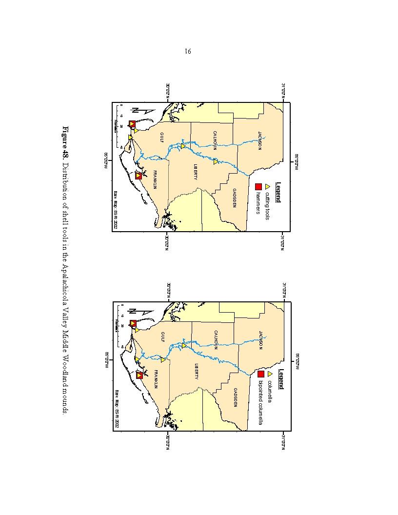
104
105
106
107 Table 10 Shell Artifacts at Apalachicola Valley Middle Woodland Mounds Site Name Hammer tools Cutting tools Tools Utensils Bipointed Columella tools Columella tools Dishes Scoops/ Spoons Spatulas Cups beads gorgets pendents hairpins Davis' Field (8Ca1) X OK Landing (8Ca2) Gaston Spivey (8Ca114) Porter's Bar (8Fr1) X X X X X X Brickyard Creek (8Fr8) X Eleven Mile Point (8Fr10) Green Point (8Fr11) X X X X X Huckleberry Landing (8Fr12) X Pierce Mounds (8Fr14) X X X X X Jackson Mound GV (8Fr15) Cool Springs Mound (8Fr19) Aspalaga Landing Mounds (8Gd1) X X Mound Near Indian Pass Point (8Gu1) X X Gotier Hammock (8Gu2) X X X Burgess Landing (8Gu3) Isabel Landing (8Gu4) Chipola Cutoff (8Gu5) X X X X X Richardson's Hammock (8Gu10) X X X X X X X X Howard Creek Mound (8Gu41) Sampson's Landing (8Ja1) X Kemp's Landing (8Ja2) Waddell's Mill Pond Site (8Ja65) Watson's Field GV (8Ja93) Poplar Springs Mound (8Ja138) Patrick Pond (8Ja325) Mound Below Bristol (8Li3) X X Bristol Mound (8Li4) X X Rock Bluff Landing (8Li5) X Michaux Log Landing GV (8Li6) Estiffanulga GV (8Li7) Ornamentals
108 Exotic materials. Exotic materials are those resources that are not available or common to the local area. In some cases, small traces of a material may have been obtained locally, but larger quantities (enough to make an object) were only accessible through trade. Inhabitants traveled or traded long distances for these materials or artifacts made from it. Beads, pendants, pipes, ear spools and other non-utilitarian objects of exotic material would have been prized commodities and expected in Middle Woodland burial mounds. The presence of these objects helps archaeologists look at social or religious hierarchy, trade and exchange, and artistic endeavors. Since the sites discussed here are ceremonial mounds, it is expected they will contain many non-utilitarian objects, especially of exotic materials. The distribution of exotic materials, according to Brose and Percy (1974), indicates a Hopewell-like resource exchange network with large mound centers obtaining and distributing exotics. Exotics found within the valley are copper, mica, galena (lead), hematite (iron), steatite (soapstone), bitumen (coal), and silver (Table 11). These materials were distributed along the river and coastal sites with a propensity to cluster around the coast and the central valley area. Many of the exotic materials were found at mound centers, such as Pierce and Waddell s Mill Pond, but these are multi-component sites with large Fort Walton occupations. I believe that the raw materials for these exotics and even the artifacts themselves arrived at mound centers such as these and were then distributed as artifacts, for example mica sheets at Howard s Creek (Figure 41), mica spear point cutouts at Aspalaga Landing and Bristol Mounds, or copper ear spools at Howard s Creek. 95
109 Table 11 Exotic Artifacts at Apalachicola Valley Middle Woodland Mounds Site Name (Site #) mica galena hematite copper steatite silver bitumen Davis' Field (8Ca1) X OK Landing (8Ca2) XR Gaston Spivey (8Ca114) Porter's Bar (8Fr1) X X X X X Brickyard Creek (8Fr8) X Eleven Mile Point (8Fr10) Green Point (8Fr11) Huckleberry Landing (8Fr12) X R A Pierce Mounds (8Fr14) A A Jackson Mound GV* (8Fr15) X X X A X Cool Springs Mound (8Fr19) X Aspalaga Landing Mounds (8Gd1) A, P? R Mound Near Indian Pass Point (8Gu1) X Gotier Hammock (8Gu2) P Burgess Landing (8Gu3) X Isabel Landing (8Gu4) X Chipola Cutoff (8Gu5) R Richardson's Hammock (8Gu10) Howard Creek Mound (8Gu41) P A Sampson's Landing (8Ja1) X Kemp's Landing (8Ja2) Waddell's Mill Pond Site (8Ja65) RP R X A Watson's Field GV* (8Ja93) Poplar Springs Mound (8Ja138) Patrick Pond (8Ja325) Mound Below Bristol (8Li3) Bristol Mound (8Li4) A Rock Bluff Landing (8Li5) Michaux Log Landing GV (8Li6) Estiffanulga GV* (8Li7) * - General Vicinity Legend R = raw material, unprocessed A = exotic material processed into artifact P = raw material cut but not artifact X = material present, form unknown Of interest is the distribution of copper along the lower delta and coastal areas. The material copper, whether in its raw form or as an artifact, is distributed only at a few sites clustered at the mouth of the river. Two mound sites of the Pierce complex and four 96
110 close mounds, Howard Creek Mound (Figure 41), Huckleberry Landing, Green Point and Porter s Bar, are the only sites that have copper (Figure 51a). Waddell s Mill Pond, located at the top of the Chipola River, has copper but it is unknown as to whether the copper is from a Woodland or Mississippian context. One potential explanation for this coastal distribution is that the copper was brought down the Mississippi River and then east along the Gulf Coast to Pierce and nearby sites. Mica, either as raw material, partially cut (Figure 36 and 41), or in a cut-out shape, is spread up the Apalachicola River but only in the lower Chipola River and up at Waddell s Mill Pond (Figure 51a). Only two sites produced finished mica artifacts: spear-point forms from Aspalaga Landing Mound and Bristol Mound. A mica spear point cutout was also found at a Middle Woodland midden, Otis Hare (8Li172) (White 1991). Steatite artifacts were only found at two sites at opposite ends of the valley (Figure 51b). A steatite pipe was found at Jackson Mound, a coastal mound associated with Pierce Mounds. Waddell s Mill Pond, at the top of the Chipola River, produced the rim fragment from a steatite vessel. One of the most ornate artifacts in the valley come from Pierce Mounds. Silver-covered copper ear ornaments were the only occurrence of silver in the valley at Middle Woodland times and the only occurrence of ear spools made of copper and not clay covered with copper. Mounds producing hematite were clustered closer to the coast, with one site in the mid-valley and two in the upper valley, one on the river and Waddell s Mill Pond at the top of Chipola (Figure 51c). Only three sites produced galena, two on the coast and one in the upper valley. Bitumen was only located at two mounds on the coast (Table 11). 97
111
112
113
.")
114 Skeletal Data. Mound Near Indian Pass and Porter s Bar are the only sites to have burials with evidence of cranial deformation in the form of posterior and anterior flattening of the skull (Figure 52). These are the only instances of cranial flattening of Middle Woodland associations in the valley. Mound Near Indian Pass is the only pure Weeden Island mound in the valley and Porter s Bar is a multi-component site spanning Late Archaic to historic. Outside the Apalachicola Valley to the east, the Tucker site, on Ochlockonee Bay, is the only other Weeden Island site along this stretch of coast that has similar cranial flattening in the burials. To the west, other dual component sites such as Sowell produce burials with flattened skulls. Figure 52 shows Mound Near Indian Pass along the coast along with other coastal sites outside the watershed producing cranial flattening. Figure 52. Cranial Deformation at Apalachicola Valley Middle Woodland mounds. 101
The Florida Anthropologist
 The Florida Anthropologist Volume 64 Numbers 3-4 September-December 2011 Table of Contents From the Editors 137 Articles On the Trail of the Panther in Ancient Florida 139 Ryan J. Wheeler Excavation of
Wisconsin Sites Page 61. Wisconsin Sites
 Wisconsin Sites Page 61 Silver Mound-A Quarry Site Wisconsin Sites Silver Mound in Jackson County is a good example of a quarry site where people gathered the stones to make their tools. Although the name
Burrell Orchard 2014: Cleveland Archaeological Society Internship Amanda Ponomarenko The Ohio State University June - August 2014
 1 Burrell Orchard 2014: Cleveland Archaeological Society Internship Amanda Ponomarenko The Ohio State University June - August 2014 Selected for the 2014 Cleveland Archaeological Society Internship in
Chapter 2. Remains. Fig.17 Map of Krang Kor site
 Chapter 2. Remains Section 1. Overview of the Survey Area The survey began in January 2010 by exploring the site of the burial rootings based on information of the rooted burials that was brought to the
An early pot made by the Adena Culture (800 B.C. - A.D. 100)
") Archaeologists identify the time period of man living in North America from about 1000 B.C. until about 700 A.D. as the Woodland Period. It is during this time that a new culture appeared and made important
Archaeologists identify the time period of man living in North America from about 1000 B.C. until about 700 A.D. as the Woodland Period. It is during this time that a new culture appeared and made important
Artifacts. Antler Tools
 Artifacts Artifacts are the things that people made and used. They give a view into the past and a glimpse of the ingenuity of the people who lived at a site. Artifacts from the Tchefuncte site give special
2010 Watson Surface Collection
 2010 Watson Surface Collection Carol Cowherd Charles County Archaeological Society of Maryland, Inc. Chapter of Archeological Society of Maryland, Inc. November 2010 2011 Charles County Archaeological
Colchester Archaeological Trust Ltd. A Fieldwalking Survey at Birch, Colchester for ARC Southern Ltd
 Colchester Archaeological Trust Ltd A Fieldwalking Survey at Birch, Colchester for ARC Southern Ltd November 1997 CONTENTS page Summary... 1 Background... 1 Methods... 1 Retrieval Policy... 2 Conditions...
3. The new face of Bronze Age pottery Jacinta Kiely and Bruce Sutton
 3. The new face of Bronze Age pottery Jacinta Kiely and Bruce Sutton Illus. 1 Location map of Early Bronze Age site at Mitchelstown, Co. Cork (based on the Ordnance Survey Ireland map) A previously unknown
ROYAL MAYAN TOMB. Faculty Sponsor: Kathryn Reese-Taylor, Department of Sociology/Archaeology
 ROYAL MAYAN TOMB 93 Royal Mayan Tomb Jennifer Vander Galien Faculty Sponsor: Kathryn Reese-Taylor, Department of Sociology/Archaeology ABSTRACT Little is known about the Mortuary practices of the ruling
SERIATION: Ordering Archaeological Evidence by Stylistic Differences
 SERIATION: Ordering Archaeological Evidence by Stylistic Differences Seriation During the early stages of archaeological research in a given region, archaeologists often encounter objects or assemblages
An archaeological evaluation at 16 Seaview Road, Brightlingsea, Essex February 2004
 An archaeological evaluation at 16 Seaview Road, Brightlingsea, Essex February 2004 report prepared by Kate Orr on behalf of Highfield Homes NGR: TM 086 174 (c) CAT project ref.: 04/2b ECC HAMP group site
Tepe Gawra, Iraq expedition records
 Tepe Gawra, Iraq expedition records 1021 Last updated on March 02, 2017. University of Pennsylvania, Penn Museum Archives July 2009 Tepe Gawra, Iraq expedition records Table of Contents Summary Information...
Test-Pit 3: 31 Park Street (SK )
") -Pit 3: 31 Park Street (SK 40732 03178) -Pit 3 was excavated in a flower bed in the rear garden of 31 Park Street, on the northern side of the street and west of an alleyway leading to St Peter s Church,
-Pit 3: 31 Park Street (SK 40732 03178) -Pit 3 was excavated in a flower bed in the rear garden of 31 Park Street, on the northern side of the street and west of an alleyway leading to St Peter s Church,
Opium Cabin excavation Passport In Time July 21-25, 2014
 Opium Cabin excavation Passport In Time July 21-25, 2014 Page 1 of 14 Non-American Indian settlement of the southern Blue Mountains began with the discovery of gold in drainages of the John Day River in
T so far, by any other ruins in southwestern New Mexico. However, as
 TWO MIMBRES RIVER RUINS By EDITHA L. WATSON HE ruins along the Mimbres river offer material for study unequaled, T so far, by any other ruins in southwestern New Mexico. However, as these sites are being
7. Prehistoric features and an early medieval enclosure at Coonagh West, Co. Limerick Kate Taylor
 7. Prehistoric features and an early medieval enclosure at Coonagh West, Co. Limerick Kate Taylor Illus. 1 Location of the site in Coonagh West, Co. Limerick (based on the Ordnance Survey Ireland map)
The lithic assemblage from Kingsdale Head (KH09)
") 1 The lithic assemblage from Kingsdale Head (KH09) Hannah Russ Introduction During excavation the of potential Mesolithic features at Kingsdale Head in 2009 an assemblage of flint and chert artefacts were
1 The lithic assemblage from Kingsdale Head (KH09) Hannah Russ Introduction During excavation the of potential Mesolithic features at Kingsdale Head in 2009 an assemblage of flint and chert artefacts were
December 6, Paul Racher (P007) Archaeological Research Associates Ltd. 900 Guelph St. Kitchener ON N2H 5Z6
 Archaeological Research Associates Ltd. 900 Guelph St. Kitchener ON N2H 5Z6") Ministry of Tourism, Culture and Sport Culture Programs Unit Programs and Services Branch Culture Division 401 Bay Street, Suite 1700 Toronto ON M7A 0A7 Tel.: 416-314-2120 Ministère du Tourisme, de la
Ministry of Tourism, Culture and Sport Culture Programs Unit Programs and Services Branch Culture Division 401 Bay Street, Suite 1700 Toronto ON M7A 0A7 Tel.: 416-314-2120 Ministère du Tourisme, de la
Pottery Exchange and Interaction at the Crystal River Site (8CI1), Florida
, Florida") University of South Florida Scholar Commons Graduate Theses and Dissertations Graduate School 10-29-2015 Pottery Exchange and Interaction at the Crystal River Site (8CI1), Florida Kassie Christine Kemp
University of South Florida Scholar Commons Graduate Theses and Dissertations Graduate School 10-29-2015 Pottery Exchange and Interaction at the Crystal River Site (8CI1), Florida Kassie Christine Kemp
Human remains from Estark, Iran, 2017
 Bioarchaeology of the Near East, 11:84 89 (2017) Short fieldwork report Human remains from Estark, Iran, 2017 Arkadiusz Sołtysiak *1, Javad Hosseinzadeh 2, Mohsen Javeri 2, Agata Bebel 1 1 Department of
Fieldwalking at Cottam 1994 (COT94F)
") Fieldwalking at Cottam 1994 (COT94F) Tony Austin & Elizabeth Jelley (19 Jan 29) 1. Introduction During the winter of 1994 students from the Department of Archaeology at the University of York undertook
Fieldwalking at Cottam 1994 (COT94F) Tony Austin & Elizabeth Jelley (19 Jan 29) 1. Introduction During the winter of 1994 students from the Department of Archaeology at the University of York undertook
Moray Archaeology For All Project
 School children learning how to identify finds. (Above) A flint tool found at Clarkly Hill. Copyright: Leanne Demay Moray Archaeology For All Project ational Museums Scotland have been excavating in Moray
BALNUARAN. of C LAVA. a prehistoric cemetery. A Visitors Guide to
 A Visitors Guide to BALNUARAN of C LAVA a prehistoric cemetery Milton of Clava Chapel (?) Cairn River Nairn Balnuaran of Clava is the site of an exceptionally wellpreserved group of prehistoric burial
Artifact Assemblages from San Augustine County, Texas, Sites Recorded in by Gus E. Arnold
 Index of Texas Archaeology: Open Access Gray Literature from the Lone Star State Volume 2017 Article 21 2017 Artifact Assemblages from San Augustine County, Texas, Sites Recorded in 1939-1940 by Gus E.
Drills, Knives, and Points from San Clemente Island
 Drills, Knives, and Points from San Clemente Island Frank W. Wood Limited numbers of chipped stone artifacts that might be called finished forms were recovered from the 3- excavations by UCLA. These artifacts
Life and Death at Beth Shean
 Life and Death at Beth Shean by emerson avery Objects associated with daily life also found their way into the tombs, either as offerings to the deceased, implements for the funeral rites, or personal
Excavations at Shikarpur, Gujarat
 Excavations at Shikarpur, Gujarat 2008-2009 The Department of Archaeology and Ancient History, the M. S. University of Baroda continued excavations at Shikarpur in the second field season in 2008-09. In
Cambridge Archaeology Field Group. Fieldwalking on the Childerley Estate, Cambridgeshire. Autumn 2014 to Spring Third interim report
 Cambridge Archaeology Field Group Fieldwalking on the Childerley Estate, Cambridgeshire Autumn 2014 to Spring 2015 Third interim report Summary Field walking on the Childerley estate of Martin Jenkins
Report to the Arizona Archaeological and Historical Society on Jakob W. Sedig s Trip to Fife Lake, Michigan to Assess Archaeological Collections
 Report to the Arizona Archaeological and Historical Society on Jakob W. Sedig s Trip to Fife Lake, Michigan to Assess Archaeological Collections This report details the trip I took to Fife Lake, Michigan
Abstract. Greer, Southwestern Wyoming Page San Diego
 Abstract The Lucerne (48SW83) and Henry s Fork (48SW88) petroglyphs near the southern border of western Wyoming, west of Flaming Gorge Reservoir of the Green River, display characteristics of both Fremont
The first men who dug into Kent s Stonehenge
 From: Paul Tritton, Hon. Press Officer Email: paul.tritton@btinternet.com. Tel: 01622 741198 The first men who dug into Kent s Stonehenge Francis James Bennett (left) and a colleague at Coldrum Longbarrow
1. Presumed Location of French Soundings Looking NW from the banks of the river.
 SG02? SGS SG01? SG4 1. Presumed Location of French Soundings Looking NW from the banks of the river. The presumed location of SG02 corresponds to a hump known locally as the Sheikh's tomb. Note also (1)
Archaeological sites and find spots in the parish of Burghclere - SMR no. OS Grid Ref. Site Name Classification Period
 Archaeological sites and find spots in the parish of Burghclere - SMR no. OS Grid Ref. Site Name Classification Period SU45NE 1A SU46880 59200 Ridgemoor Farm Inhumation Burial At Ridgemoor Farm, on the
Archaeological Material From Spa Ghyll Farm, Aldfield
 Archaeological Material From Spa Ghyll Farm, Aldfield Introduction Following discussions with Linda Smith the Rural Archaeologist for North Yorkshire County Council, Robert Morgan of 3D Archaeological
Hembury Hillfort Lesson Resources. For Key Stage Two
 Hembury Hillfort Lesson Resources For Key Stage Two 1 Resource 1 Email 1 ARCHAEOLOGISTS NEEDED Dear Class, I recently moved to Payhembury and I have been having fun exploring the beautiful Blackdown Hills.
ST PATRICK S CHAPEL, ST DAVIDS PEMBROKESHIRE 2015
 ST PATRICK S CHAPEL, ST DAVIDS PEMBROKESHIRE 2015 REPORT FOR THE NINEVEH CHARITABLE TRUST THE UNIVERSITY OF SHEFFIELD AND DYFED ARCHAEOLOGICAL TRUST Introduction ST PATRICK S CHAPEL, ST DAVIDS, PEMBROKESHIRE,
January 13 th, 2019 Sample Current Affairs
 January 13 th, 2019 Sample Current Affairs 1. Harappa grave of ancient 'couple' reveals secrets of Marriage What are the key takeaways of the excavation? Was marriage legally accepted in Harappan society?
39, Walnut Tree Lane, Sudbury (SUY 073) Planning Application No. B/04/02019/FUL Archaeological Monitoring Report No. 2005/112 OASIS ID no.
 Planning Application No. B/04/02019/FUL Archaeological Monitoring Report No. 2005/112 OASIS ID no.") 39, Walnut Tree Lane, Sudbury (SUY 073) Planning Application No. B/04/02019/FUL Archaeological Monitoring Report No. 2005/112 OASIS ID no. 9273 Summary Sudbury, 39, Walnut Tree Lane, Sudbury (TL/869412;
39, Walnut Tree Lane, Sudbury (SUY 073) Planning Application No. B/04/02019/FUL Archaeological Monitoring Report No. 2005/112 OASIS ID no. 9273 Summary Sudbury, 39, Walnut Tree Lane, Sudbury (TL/869412;
h i s t om b an d h i s t r e a su r e s Worksheet CArter ArChAeoLoGY
 1 Worksheet CARTER ARCHAEOLOGY 2 1. Howard Carter s discovery Text A The Valley of the Kings The Valley of the Kings is on the west bank of the Nile, opposite the ancient city of Thebes. Thebes is called
THE RAVENSTONE BEAKER
 DISCOVERY THE RAVENSTONE BEAKER K. J. FIELD The discovery of the Ravenstone Beaker (Plate Xa Fig. 1) was made by members of the Wolverton and District Archaeological Society engaged on a routine field
An archaeological evaluation in the playground of Colchester Royal Grammar School, Lexden Road, Colchester, Essex
 An archaeological evaluation in the playground of Colchester Royal Grammar School, Lexden Road, Colchester, Essex February 2002 on behalf of Roff Marsh Partnership CAT project code: 02/2c Colchester Museum
Fort Arbeia and the Roman Empire in Britain 2012 FIELD REPORT
 Fort Arbeia and the Roman Empire in Britain 2012 FIELD REPORT Background Information Lead PI: Paul Bidwell Report completed by: Paul Bidwell Period Covered by this report: 17 June to 25 August 2012 Date
AMERICA S ADENA MOUNDBUILDERS
 AMERICA S ADENA MOUNDBUILDERS And Their Burial Tablets By Ida Jane Gallagher. Author, Contact with Ancient America Epigrapher since 1977 and colleague of many advocates of ancient America for 30 years.
<Plate 4 here, in b/w> Two Cahokia s Coles Creek Predecessors Vincas P. Steponaitis, Megan C. Kassabaum, and John W. O Hear
 [To be published in Medieval Mississippians: The Cahokian World, edited by Susan M. Alt and Timothy R. Pauketat, SAR Press, Santa Fe. Draft of November 20, 2013.] Two Cahokia s Coles
Determining Fort Walton burial patterns and their relationship within the greater Mississippian world
 University of South Florida Scholar Commons Graduate Theses and Dissertations Graduate School 2008 Determining Fort Walton burial patterns and their relationship within the greater Mississippian world
New Composting Centre, Ashgrove Farm, Ardley, Oxfordshire
 New Composting Centre, Ashgrove Farm, Ardley, Oxfordshire An Archaeological Watching Brief For Agrivert Limited by Andrew Weale Thames Valley Archaeological Services Ltd Site Code AFA 09/20 August 2009
Novington, Plumpton East Sussex
 Novington, Plumpton East Sussex The Flint Over 1000 pieces of flintwork were recovered during the survey, and are summarised in Table 0. The flint is of the same types as found in the previous survey of
Bronze Age 2, BC
 Bronze Age 2,000-600 BC There may be continuity with the Neolithic period in the Early Bronze Age, with the harbour being used for seasonal grazing, and perhaps butchering and hide preparation. In the
STONE implements and pottery indicative of Late Neolithic settlement are known to
 Late Neolithic Site in the Extreme Northwest of the New Territories, Hong Kong Received 29 July 1966 T. N. CHIU* AND M. K. WOO** THE SITE STONE implements and pottery indicative of Late Neolithic settlement
"Roll Out the Beryl" by Dave Lines, John Sorg, Ralph Gamba, Mary Cramer, Mike Saniga and Patrick Saniga
 "Roll Out the Beryl" by Dave Lines, John Sorg, Ralph Gamba, Mary Cramer, Mike Saniga and Patrick Saniga On the morning of April 17th, six members of the Southern Maryland Rock and Mineral Club met at a
Documentation of Cemeteries and Funerary Offerings from Sites in the Upper Neches River Basin, Anderson, Cherokee, and Smith Counties, Texas
 Stephen F. Austin State University SFA ScholarWorks CRHR: Archaeology Center for Regional Heritage Research 2014 Documentation of Cemeteries and Funerary Offerings from Sites in the Upper Neches River
Tell Shiyukh Tahtani (North Syria)
") Tell Shiyukh Tahtani (North Syria) Report of the 2010 excavation season conducted by the University of Palermo Euphrates Expedition by Gioacchino Falsone and Paola Sconzo In the summer 2010 the University
Tell Shiyukh Tahtani (North Syria) Report of the 2010 excavation season conducted by the University of Palermo Euphrates Expedition by Gioacchino Falsone and Paola Sconzo In the summer 2010 the University
Unit 6: New Caledonia: Lapita Pottery. Frederic Angleveil and Gabriel Poedi
 Unit 6: New Caledonia: Lapita Pottery Frederic Angleveil and Gabriel Poedi Facts Capital Main islands Highest point Language Government Noumea Grande Terre, 3 Loyalty Islands and numerous reefs and atolls
AN ANALYSIS OF EARLY MISSISSIPPIAN BURIALS FROM MOUND C AT OCMULGEE, GEORGIA. By Rachel Metcalf
 AN ANALYSIS OF EARLY MISSISSIPPIAN BURIALS FROM MOUND C AT OCMULGEE, GEORGIA By Rachel Metcalf Honors Thesis Curriculum in Archaeology University of North Carolina at Chapel Hill 2017 Approved: Vincas
Xian Tombs of the Qin Dynasty
 Xian Tombs of the Qin Dynasty By History.com, adapted by Newsela staff In 221 B.C., Qin Shi Huang became emperor of China, and started the Qin Dynasty. At this time, the area had just emerged from over
DEMARCATION OF THE STONE AGES.
 20 HAMPSHIRE FLINTS. DEMARCATION OF THE STONE AGES. BY W, DALE, F.S.A., F.G.S. (Read before the Anthropological Section of -the British Association for the advancement of Science, at Birmingham, September
STONES OF STENNESS HISTORIC ENVIRONMENT SCOTLAND STATEMENT OF SIGNIFICANCE
 Property in Care (PIC) ID: PIC321 Designations: Scheduled Monument (SM90285); Taken into State care: 1906 (Guardianship) Last reviewed: 2003 HISTORIC ENVIRONMENT SCOTLAND STATEMENT OF SIGNIFICANCE STONES
Control ID: Years of experience: Tools used to excavate the grave: Did the participant sieve the fill: Weather conditions: Time taken: Observations:
 Control ID: Control 001 Years of experience: No archaeological experience Tools used to excavate the grave: Trowel, hand shovel and shovel Did the participant sieve the fill: Yes Weather conditions: Flurries
ARCHAEOLOGICAL EVALUATION AT BRIGHTON POLYTECHNIC, NORTH FIELD SITE, VARLEY HALLS, COLDEAN LANE, BRIGHTON. by Ian Greig MA AIFA.
 ARCHAEOLOGICAL EVALUATION AT BRIGHTON POLYTECHNIC, NORTH FIELD SITE, VARLEY HALLS, COLDEAN LANE, BRIGHTON by Ian Greig MA AIFA May 1992 South Eastern Archaeological Services Field Archaeology Unit White
I MADE THE PROBLEM UP,
 This assignment will be due Thursday, Oct. 12 at 10:45 AM. It will be late and subject to the late penalties described in the syllabus after Friday, Oct. 13, at 10:45 AM. Complete submission of this assignment
An archaeological evaluation at the Lexden Wood Golf Club (Westhouse Farm), Lexden, Colchester, Essex
, Lexden, Colchester, Essex") An archaeological evaluation at the Lexden Wood Golf Club (Westhouse Farm), Lexden, Colchester, Essex January 2000 Archive report on behalf of Lexden Wood Golf Club Colchester Archaeological Trust 12 Lexden
An archaeological evaluation at the Lexden Wood Golf Club (Westhouse Farm), Lexden, Colchester, Essex January 2000 Archive report on behalf of Lexden Wood Golf Club Colchester Archaeological Trust 12 Lexden
4 July 8, 2015 Public Hearing
 4 July 8, 2015 Public Hearing APPLICANT: STUDIO EVOLVE, LLC PROPERTY OWNER: MT. TRASHMORE OFFICE, LC STAFF PLANNER: Carolyn A.K. Smith REQUEST: Modification of a Conditional Use Permit approved by the
Lanton Lithic Assessment
 Lanton Lithic Assessment Dr Clive Waddington ARS Ltd The section headings in the following assessment report refer to those in the Management of Archaeological Projects (HBMC 1991), Appendix 4. 1. FACTUAL
Cultural Design with History in Mind
 Cultural Design with History in Mind Tuesday, February 12, 2013 12:00 pm - 4:00 pm Latte of Freedom, Adelup Examples of Stylistic Designs on Marianas Pottery A presentation by Darlene R. Moore Sponsored
The Prehistoric Indians of Minnesota
 The Prehistoric Indians of Minnesota The Mille Lacs Aspect^ Uoyd A. Wilford FROM THE HISTORICAL point of view the most interesting aspect of the Woodland pattern in Minnesota is the Mille Lacs, for this
Art History: Introduction 10 Form 5 Function 5 Decoration 5 Method 5
 Art History: Introduction 10 Form 5 Function 5 Decoration 5 Method 5 Pre-Christian Ireland Intro to stone age art in Ireland Stone Age The first human settlers came to Ireland around 7000BC during the
THE EXCAVATIONS AT MOUND BOTTOM, A PALISADED MISSISSIPPIAN CENTER IN CHEATHAM COUNTY, TENNESSEE
 THE 1974 75 EXCAVATIONS AT MOUND BOTTOM, A PALISADED MISSISSIPPIAN CENTER IN CHEATHAM COUNTY, TENNESSEE Michael J. O Brien 1 and Carl Kuttruff 2 Mound Bottom (40CH8) is a large complex of 14 prehistoric
FINDING LIFE FROM GRAVE GOODS
 FINDING LIFE FROM GRAVE GOODS Summary: In archaeology classes it appears that students are often told what the correct answer is, rather than being forced to make inferences themselves based upon archaeological
12 October 14, 2015 Public Hearing
 12 October 14, 2015 Public Hearing APPLICANT: SECOND SHOT, LLC PROPERTY OWNER: ALBERT VINCIGUERRA STAFF PLANNER: Kevin Kemp REQUEST: Conditional Use Permit (Tattoo Parlor) ADDRESS / DESCRIPTION: 5759 Princess
The Function of a Middle Woodland Site in the Central Illinois Valley: A Ceramic Study of Ogden- Fettie
 Illinois State University ISU ReD: Research and edata Theses and Dissertations 11-1-2013 The Function of a Middle Woodland Site in the Central Illinois Valley: A Ceramic Study of Ogden- Fettie Montana
LARKHILL MARRIED QUARTERS ARCHAEOLOGY OF THE FIRST WORLD WAR BY MARK KHAN
 LARKHILL MARRIED QUARTERS ARCHAEOLOGY OF THE FIRST WORLD WAR BY MARK KHAN As many people may have seen recently on television the Army Basing Project responsible for the construction of new service accommodation
A Preliminary Archaeological Survey of the Spencer Marsh House, Walker County, Georgia
 A Preliminary Archaeological Survey of the Spencer Marsh House, Walker County, Georgia By Nicholas Honerkamp, PhD Jeffrey L. Brown Institute of Archaeology University of Tennessee at Chattanooga Chattanooga,
Azerbaijan National Academy of Sciences Institute of Archaeology and Ethnography. Safar Ashurov
 Azerbaijan National Academy of Sciences Institute of Archaeology and Ethnography Safar Ashurov Zayamchay Report On Excavations of a Catacomb Burial At Kilometre Point 355 of Baku-Tbilisi-Ceyhan and South
Evidence for the use of bronze mining tools in the Bronze Age copper mines on the Great Orme, Llandudno
 Evidence for the use of bronze mining tools in the Bronze Age copper mines on the Great Orme, Llandudno Background The possible use of bronze mining tools has been widely debated since the discovery of
Jane C. Waldbaum Archaeology Field School Scholarship. It was difficult at first to adjust to the ten-hour time change, but my body quickly
 Hart 1 American Institute of Archaeology Field School Report Jane C. Waldbaum Archaeology Field School Scholarship Ashlee Hart 8 August 2013 The day began with roosters crowing and an alarm clock pounding
good for you be here again down at work have been good with his cat
 Fryʼs Phrases This list of 600 words compiled by Edward Fry contain the most used words in reading and writing. The words on the list make up almost half of the words met in any reading task. The words
Additional Multi-Holed Tablets from the Fred Aldrich Collection, Bowers Museum of Cultural Art, Santa Ana
 Additional Multi-Holed Tablets from the Fred Aldrich Collection, Bowers Museum of Cultural Art, Santa Ana Henry C. Koerper and Joe Cramer Abstract The primary purpose of this article is to acquaint readers
Journal of. Alabama Archaeology. Volume 61 Numbers 1 and CONTENTS
 Journal of Alabama Archaeology Volume 61 Numbers 1 and 2 2015 CONTENTS v Volume Editors Preface John H. Blitz and Grace E. Riehm 1 Introduction to the Andrews Place Site (1MB1) Jason A. Gardner and Clare
Evolution of the Celts Unetice Predecessors of Celts BCE Cultural Characteristics:
 Evolution of the Celts Unetice Predecessors of Celts 2500-2000 BCE Associated with the diffusion of Proto-Germanic and Proto-Celto-Italic speakers. Emergence of chiefdoms. Long-distance trade in bronze,
Advanced archaeology at the archive. Museum of London Support materials AS/A2 study day
 Advanced archaeology at the archive Support materials AS/A2 study day Contents National Curriculum links and session description 1-2 Example timetable 3 Practical guidelines 4 Visit preparation and pre-visit
TO STUDY THE RETAIL JEWELER S IMPORTANCE TOWARDS SELLING BRANDED JEWELLERY
 TO STUDY THE RETAIL JEWELER S IMPORTANCE TOWARDS SELLING BRANDED JEWELLERY Prof. Jiger Manek 1, Dr.Ruta Khaparde 2 ABSTRACT The previous research done on branded and non branded jewellery markets are 1)
A NEW ROMAN SITE IN CHESHAM
 A NEW ROMAN SITE IN CHESHAM KEITH BRANIGAN AND MICHAEL KIRTON THE site under discussion was first noted in 1958 and since that time several discoveries have been made. Its investigation has been pursued
LATE BRONZE AND EARLY IRON AGE MONUMENTS IN THE BTC AND SCP PIPELINE ROUTE: ZAYAMCHAY AND TOVUZCHAY NECROPOLEIS
 SHAMIL NAJAFOV LATE BRONZE AND EARLY IRON AGE MONUMENTS IN THE BTC AND SCP PIPELINE ROUTE: ZAYAMCHAY AND TOVUZCHAY NECROPOLEIS The Zayamchay and Tovuzchay basins, which are rich in archaeological monuments,
Kolomoki Memoirs. Williams H. Sears. Edited with a Preface By. Mark Williams and Karl T. Steinen University of Georgia and University of West Georgia
 Kolomoki Memoirs By Williams H. Sears Edited with a Preface By Mark Williams and Karl T. Steinen University of Georgia and University of West Georgia University of Georgia Laboratory of Archaeology Series
T the prehistory of the eastern part of the United States in the last ten
 American Anthropologist NEW SERIES VOL. 43 JULY-SEPTEMBER No. 3, PART 1 AN INTERPRETATION OF THE PREHISTORY OF THE EASTERN UNITED STATES By J. A. FORD and GORDON R. WLLLEY INTRODUCTION HERE has been a
Documentation of Caddo Funerary Objects from the Crenshaw Site (3MI6) in the Gilcrease Museum Collections
 in the Gilcrease Museum Collections") Stephen F. Austin State University SFA ScholarWorks CRHR: Archaeology Center for Regional Heritage Research 2013 Documentation of Caddo Funerary Objects from the Crenshaw Site (3MI6) in the Gilcrease Museum
Stephen F. Austin State University SFA ScholarWorks CRHR: Archaeology Center for Regional Heritage Research 2013 Documentation of Caddo Funerary Objects from the Crenshaw Site (3MI6) in the Gilcrease Museum
CONEHEAD EFFIGIES: A DISTINCTIVE ART FORM OF THE MISSISSIPPI VALLEY. George E. Lankford 1 and David H. Dye 2
 CONEHEAD EFFIGIES: A DISTINCTIVE ART FORM OF THE MISSISSIPPI VALLEY George E. Lankford 1 and David H. Dye 2 1 Professor Emeritus of Folklore, Lyon College 2 Professor of Archaeology, University of Memphis
Archaeological Investigations at the Catoma Creek Site (1MT209): A Cobbs Swamp Phase Site in East-Central Alabama
: A Cobbs Swamp Phase Site in East-Central Alabama") 20 Journal of Alabama Archaeology Archaeological Investigations at the Catoma Creek Site (1MT209): A Cobbs Swamp Phase Site in East-Central Alabama Thomas M. Shelby, Kareen L. Hawsey, and Sharon A. Freeman
20 Journal of Alabama Archaeology Archaeological Investigations at the Catoma Creek Site (1MT209): A Cobbs Swamp Phase Site in East-Central Alabama Thomas M. Shelby, Kareen L. Hawsey, and Sharon A. Freeman
CEREMONIAL KILLING OF HOPEWELL ITEMS RECOVERED FROM REDEPOSIT PITS IN MANN MOUND 3, POSEY COUNTY, INDIANA. A thesis submitted
 CEREMONIAL KILLING OF HOPEWELL ITEMS RECOVERED FROM REDEPOSIT PITS IN MANN MOUND 3, POSEY COUNTY, INDIANA A thesis submitted To Kent State University in partial Fulfillment of the requirements for the
The St. George s Caye Archaeology Project:
 The St. George s Caye Archaeology Project: Results of the 2015 Field Season Edited by James F. Garber Texas State University June, 2016 2 THE ST. GEORGE S CAYE ARCHAEOLOGY PROJECT: RESULTS OF THE 2015
Greater London GREATER LONDON 3/606 (E ) TQ
 TQ") GREATER LONDON City of London 3/606 (E.01.6024) TQ 30358150 1 PLOUGH PLACE, CITY OF LONDON An Archaeological Watching Brief at 1 Plough Place, City of London, London EC4 Butler, J London : Pre-Construct
GREATER LONDON City of London 3/606 (E.01.6024) TQ 30358150 1 PLOUGH PLACE, CITY OF LONDON An Archaeological Watching Brief at 1 Plough Place, City of London, London EC4 Butler, J London : Pre-Construct
Unit 3 Hair as Evidence
 Unit 3 Hair as Evidence A. Hair as evidence a. Human hair is one of the most frequently pieces of evidence at the scene of a violent crime. Unfortunately, hair is not the best type of physical evidence
Scientific evidences to show ancient lead trade with Tissamaharama Sri Lanka: A metallurgical study
 Scientific evidences to show ancient lead trade with Tissamaharama Sri Lanka: A metallurgical study Arjuna Thantilage Senior Lecturer, Coordinator, Laboratory for Cultural Material Analysis (LCMA), Postgraduate
Global Prehistory. 30, BCE The Origins of Images
 Global Prehistory 30,000-500 BCE The Origins of Images Key Points for Global Prehistory Periods and definitions Prehistory (or the prehistoric period) refers to the time before written records, however,
SALVAGE EXCAVATIONS AT OLD DOWN FARM, EAST MEON
 Proc. Hants. Field Club Archaeol. Soc. 36, 1980, 153-160. 153 SALVAGE EXCAVATIONS AT OLD DOWN FARM, EAST MEON By RICHARD WHINNEY AND GEORGE WALKER INTRODUCTION The site was discovered by chance in December
Cetamura Results
 Cetamura 2000 2006 Results A major project during the years 2000-2006 was the excavation to bedrock of two large and deep units located on an escarpment between Zone I and Zone II (fig. 1 and fig. 2);
Church of St Peter and St Paul, Great Missenden, Buckinghamshire
 Church of St Peter and St Paul, Great Missenden, Buckinghamshire An Archaeological Watching Brief for the Parish of Great Missenden by Andrew Taylor Thames Valley Archaeological Services Ltd Site Code
Request Conditional Use Permit (Tattoo Parlor) Staff Planner Kevin Kemp
 Staff Planner Kevin Kemp") Applicant Property Owner Dam Neck Square, LLC Public Hearing March 9, 2016 City Council Election District Beach Agenda Item 2 Request Conditional Use Permit (Tattoo Parlor) Staff Planner Kevin Kemp Location
Applicant Property Owner Dam Neck Square, LLC Public Hearing March 9, 2016 City Council Election District Beach Agenda Item 2 Request Conditional Use Permit (Tattoo Parlor) Staff Planner Kevin Kemp Location
Medieval Burials and the Black Death
 Medieval Burials and the Black Death A Report on Badia Pozzeveri, Italy Bioarchaeology Field School Summer 2015 During the summer of 2015, I was given the opportunity to participate in the Ohio State University/Universitá