Colchester ircnaeoloqist
|
|
|
- Justina Bradley
- 5 years ago
- Views:
Transcription
1


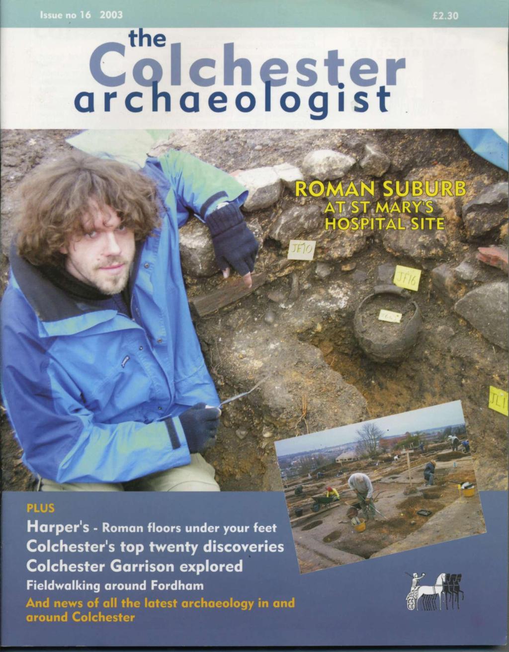
2 Colchester ircnaeoloqist Colchester Archaeological Trust 2003 ISSN The Colchester archaeologist magazine is supported by the Friends of Colchester Archaeological Trust (see page 32). The Trust is grateful to all those clients who commissioned and funded projects, and to building contractors who provided support on site. The following companies and individuals kindly assisted with the projects included in this issue of the Colchester Archaeologist: Alresford Sand & Ballast Ltd, Barratt Eastern Counties Ltd, Richard and Roger Browning, Colbert Consultancy Services, Colchester Borough Council, the Environment Agency, the Essex Wildlife Trust,Harding Homes, Harpers of Colchester Ltd, Hills Residential Ltd, Hutton Construction Ltd, Jaygate Homes Ltd, the Ministry of Defence, RMPA Services, Tendring Construction Ltd, Vaughan & Blyth Ltd, and the Woodland Trust, The Trust is also grateful to Colchester Borough Council for placing an advertisement on page 33 and for its support of the magazine. With thanks to all the contributors to this issue of the magazine: Dan Geary, Nina Crummy, Essex County Council Field Archaeology Unit, Kate Orr, Mark Taylor and David Hill, and J J Wymer. All images copyright Colchester Archaeological Trust unless stated otherwise Designed and produced by the Colchester Archaeological Trust Unattributed text by Philip Crummy Printed by PrintWright Ltd, Ipswich Colchester Archaeological Trust 12 Lexden Road, Colchester, Essex C03 3NF tel.: (01206) tel./fax: (01206) archaeologists@catuk.org website: Friends of the Colchester Archaeological Trust If you are interested in following archaeological discoveries in Colchester, then why not consider joining the Friends of the Colchester Archaeological Trust? Membership continues to rise and now stands at about 450 individuals and families. The subscription rates are modest, and include an annual copy of the Colchester archaeologist magazine delivered to you as soon as it is published. You can also join tours of current sites and organised trips to places of historical and archaeological interest in the region. The annual subscription rates: Family membership 6.00 Adults and institutions 5.00 Children and students 2.50 Further details can be obtained from Maureen Jones, Friends of Colchester Archaeological Trust, 5 Ashwin Avenue, Copford, Colchester, Essex C06 1BS or Front cover: Polish archaeologist Mariusz Gorniak working on the St Mary's Hospital site. Below: 180 degree panorama photograph of the St Mary's Hospital site with Jumbo, the Balkerne Gate, and the Roman town wall on the right. Looking north. The Colchester Archaeological Trust is a full-time professional unit. It is a registered charity and a company limited by guarantee. The Trust was founded in 1963 as the Colchester Excavation Committee.


3 contents In brief... 2 Mammoth find at Marks Tey by J J Wymer 4 Urnfield discovered at Great Tey by Dan Cleary 5 A walk in the woods at Fordham by Howard Brooks 6 Camulodunum explored 7 The western suburb: excavations on the site of St Mary's Hospital The west end of the Roman town Sir Mortimer Wheeler's first dig High class development north of the river Harpers: Roman floors under your feet Colchester's top 20 archaeological discoveries Head on a pole Latest replicas of glass beakers from Roman Colchester 29 by Mark Taylor and David Hill Life and death at St Osyth by Essex County Council Field Archaeology Unit Ron Bourton and Dan Biglin Launch of May Day journal Friends of the Colchester Archaeological Trust Mike Ripley: crime writer and archaeologist


4 Quarter century The Friends of the Colchester Archaeological Trust is twenty-five years old. To mark its birthday, a special exhibition was held last summer in the Minories Art Gallery featuring about forty of Peter Froste's reconstruction paintings of Colchester. Work by Sarah Sabine was also included. See page 32 for more details. Leaping to conclusions PETER FROSTE An unusual Roman basin was the cause of much head scratching when it was uncovered during the excavations on the Post Office site in Head Street in The basin had clearly been associated with water, but what was it for? The eventual verdict was that it had been an ornamental pool in the rear garden of a large Roman house. Now this conclusion has had some recent support from an unexpected source: frog bones! As part of her study of the bone assemblage from the site, animal bone specialist Julie Curl has identified eight frog bones from various Roman pits on the site. Given how rarely frog bones are identified from Roman sites (the last ones in Colchester were discovered in 1970), it seems quite possible that the Head Street frogs lived in and around the pool. Curiously the Head Street site has produced some other rarely-found bones. These include badger (possibly hunted for their pelts), otter (probably caught for their fur), and a single brown bear bone. In brief... The fly and the finger-ring An unusual gemstone engraved with a fly is one of the latest objects to be studied from the former Post Office site in Head Street excavated in 2000 (now occupied by the new multiplex cinema). The image, which has been cut with great skill and in some detail, seems to represent a horsefly viewed directly from above. It has a large head, prominent eyes and delicately veined wings. The engraved stone would have been set in a finger-ring, but presumably it became detached and was lost as a result. actual size The stone is quartz with thin coloured bands. The gem-cutter has coloured the fly by cutting the image through the blue upper band which forms the surface of the stone to reveal a darker band below. Martin Henig, an expert in Roman art, thinks the gem-cutter and his patron may have intended to trick people into thinking that there really was a fly on the ring. He says that not only is it unusual for images on gemstones to be so naturalistic, but it is also rare for them to show subjects at around actual size. This is the first image of a fly on an intaglio from Britain, and they seem to have been rare in Gaul too. Martin Henig also wonders if the owner's surname was Musca, meaning 'fly'. Web site The Colchester Archaeological Trust has a web-site. It features the latest news about sites and publications in Colchester, as well as clickable maps which allow visitors to explore interactively some Colchester archaeological sites. Visit us at Research fund There is much to do in the Colchester area and much to find out, yet little is possible without funds. Volunteers do and have played important roles, but money is nearly always needed to pay for key staff time, external specialist reports, and running costs. For example, the cultivated fields in the Gosbecks area offer great potential and badly need to be investigated because of the slow erosive effect of ploughing. Our volunteer geophysics team, Aline and David Black, Tim Dennis, and Peter Cott, are well into their huge survey at Gosbecks, but we need to follow this up with fieldwalking, some excavation, and publication. Donations, gifts or bequests will all help, no matter what the size. Open for visitors Rain or shine, members of the public were given guided tours around the St Mary's Hospital site throughout November and December. It was simply a matter of turning up at the gate at am each morning for a free tour. The picture shows Hannah Higgins surveying in the foreground.
. Findings from some of the smaller projects are described here.")


, although it was almost certainly in use into the Roman period.")
5 Round-up of 2002 It was a busy year for the Trust with 33 watching briefs, 16 evaluations (including the massive evaluation at the Garrison - see pages 10-15), and two excavations, one of which was at St Mary's Hospital (see pages 7-9). Findings from some of the smaller projects are described here. Topsoil stripping at Brightlingsea Quarry revealed ditches apparently dug in the Neolithic period as part of a field system. Early Neolithic and later Bronze Age pottery had been found previously in the area but not in field ditches. Neolithic field systems have not yet been identified in Essex, so if these ditches really are of this date, then they would be the earliest known in Essex. Continuity of activity into the Early Bronze Age was shown by a disturbed 'Beaker' burial where only the Beaker pot remained. A large sherd from a Middle Bronze Age urn, found in ploughsoil, ties in with evidence of a cemetery of the same date 350m away. Worked flint in pits and field ditches was mainly Neolithic/Bronze Age, but included a Mesolithic flake used for re-shaping axes. Flint tools apparently of Iron Age date were also recovered. Roman activity on site was confined to the apparent addition of ditches to the older field system. It is clear that although there is no settlement evidence, people were hunting, farming and burying their dead on this land for at least 4,000 years. The creation of new creeks at Abbott's Hall Farm in Great Wigborough exposed a previously unrecorded but flattened 'red hill'. This is one of many salt-extraction sites which existed the Essex coast. Pottery in the reddened earth suggests that the red hill dates from the Middle Iron Age (c BC), although it was almost certainly in use into the Roman period. There was also a midden of oyster shells with fragments of cooking pots of late 13th- to 14th-century date. Colchester's town centre and environs have continued to produce evidence of its Roman past as redevelopment carries on apace. Outside the town walls, in the Roman 'Western cemetery' in Lexden, a cremation was found during an evaluation at Handford House on Beverley Road. Some human remains were also found in Alexandra Road, along with Roman pits and building debris. These remains were close to the site of the large Roman cemetery excavated in the 1970s and early 1980s near the police station on Butt Road, The Trust worked with several medieval standing structures during the year. Works to convert the old 'Bonds' building at North Hill gave an opportunity to record original medieval foundations and floor surfaces. A vaulted brick ceiling to a cellar dating to the late 17th or 18th centuries was also exposed there. The former Bonds shop is known for the remarkable wall-paintings in one of the rooms. Building work and environmental improvements also gave the Trust an opportunity to investigate buried medieval archaeology. A small trench was excavated behind 36 North Hill for the construction of some new flats where the remains of Roman buildings were expected. Instead, over a metre down, were organic layers which had preserved three leather shoe soles dating to the 15th and 16th centuries. Kate Orr Handford House, Roman burial site. Right: remains of a partly- preserved Roman cremation. Abbotts Hall Farm - the creation of the creek was followed by the breaching of the sea wall. Below. Bonds shop on North Hill Part of the painted wall decoration. The paintings were discovered in about 1911 and fully exposed in The scheme only survives on parts of two walls, but presumably it covered all the walls in the room. The paintings date to c 1600 and imitate wooden panelling incorporating floral designs. The artist used trompe I'oeil effects to give his colourful design a 3-D appearance. The paintings were conserved by Andrea Kirkham as part of a heritage lottery-funded building repair (Colchester Borough Council and English Heritage). Original research on the painting was undertaken by Tom Organ and Andrea Kirkham. Left. An original 15th-century window at Bonds. Viewed from the inside. 3

6 Mammoth find at Marks Tey by J J Wymer For over thirty years, retired farmer Tony Bonner has had part of an ancient mammoth on display in his living room. The tusk was found sometime before 1971, ten feet down in the clay-pit in the brickworks at Marks Tey near Colchester. It was given to him at the time by his friend Jim Collier whose family owned the pit. Tony recently brought the find to the Trust's office in Lexden Road so that it could be recorded. John Wymer, a renowned specialist in Palaeolithic archaeology, explains the significance of this and other similar finds from the Colchester area. Mr Tony Bonner with the mammoth tusk fragment from Marks Tey Although only a small section of the very large tusks on a mammoth, its curvature is enough to indicate that it has come from a mammoth, and not the other type of elephant that once lived in Britain: the straight-tusked elephant. Mammoths were well adapted to cold conditions, so it is particularly interesting that this one was found in the pit at Marks Tey. This is because Colliers Pit is a famous site for people who study the history of the so-called Ice Age in Britain, for it is the only site in Britain where ancient lake beds in a steep-sided basin (the clay which is used to make the bricks at Colliers) cover the whole period of a relatively warm inter-glacial period, from the gradual disappearance of glacial ice, through temperate and late-temperate climate until the onset of another cold period, probably some 30,000 years or more. These deposits were investigated in great detail by Dr Charles Turner of the University of Cambridge in the late 1960s and published in 1970, the changing climate and local landscape interpreted from the fossil pollen in the lake muds. No remains of any large mammals were found, and yet here is the presence of an animal that ought to be on some cold tundra elsewhere! The answer is that the company carefully recorded that it was found only 'ten feet down', ie in the upper part of the pit. At this time, it could be shown that woodland was giving way to grassland and eventually a sub-arctic park woodland. So, our mammoth was seemingly living in the right place. It is, as stated, the only known remains of any contemporary animal in these deposits. In spite of the lack of any other fossil mammal bones from Marks Tey, there are several other known sites in the Colchester area which have yielded them. Some were recorded by W H Dalton of the Geological Survey in his published Memoir for the neighbourhood of Colchester in As early as 1764, 'a number of large bones, vertebrae and tibia' was found on the south side of the London Road at Stanway Manor House. They were also very abundant in a pit north of Copford Place which is marked on an old Ordnance Survey map, mainly collected by Mr J Brown of Stanway and now preserved in the British Museum (Natural History). These bones include Bison, Bos, Beaver, Red Deer, Mammoth,?Horse and Hippopotamus. The presence of both Mammoth and Hippopotamus suggests that they must have come from different levels in the pit, for Hippopotamus is only found in interglacial sites and Mammoth in cold periods. There was also a brickyard at Lexden on the south side of the River Colne near the village. Here, mammalian remains were found 'in abundance'. The feet of an elephant were found in position. Whether this was mammoth or straight-tusked elephant is unknown, but the mandible of a mammoth from Lexden is in the Sedgwick Museum at Cambridge, so Mammoth is more likely. Three brick-yards are also recorded from near North Station in Colchester, one south of the railway, a second north, and a third a little further east. Bones and teeth occurred in all of them. More recently, Elephant and Bos or Bison were found during the construction of the Stanway bypass. It is evident that this western side of Colchester is worth watching whenever deep excavations are being made. Much more must remain to be found and, if some are discovered, it would be good to have the site investigated under controlled conditions, so that modern methods of dating and interpretation could be applied. As yet, there have been no reports of any Palaeolithic flint artefacts ever having been found in association with these fossil animal bones. See for yourself... A collection of various Palaeolithic mammal bones is on temporary display in Colchester Museums until at least 31st March They were dredged up from the sea by fishermen operating off the coast in the Clacton area. 4


7 Urnfield discovered at Great Tey by Dan Geary Tim Cordle with the first pot, which he discovered with the bucket of his machine. Farm worker Tim Cordle made an archaeological discovery of his own in September. He was using a mechanical excavator to remove topsoil from a field at Tey Brook Farm near Colchester so it could be covered over to expand the adjacent craft centre. Then suddenly a small hole in the ground appeared under the blade of his bucket with pieces of pottery around it. Clearing more soil by hand, he revealed two buried pots, one with fragments of bone. Mr Roger Browning, whose family have owned the farm for four generations and who is a member of the Friends of CAT, immediately contacted Philip Crummy of CAT. Philip visited the site and was able to tell him that these were cremation urns from the Middle Bronze Age. The style of pottery, known as Deverel-Rimbury, was current from about 1750 to 1200 BC, and Philip had excavated a large Bronze Age burial site not far away at Chitts Hill in 1973 that contained more than 30 similar cremations. Within days, amateur archaeologists Aline and David Black were scanning the cleared field with a magnetometer, to see what else was in the vicinity. They soon found a ring-shaped ditch, roughly 25 metres in diameter, and a straight feature that intersects the ditch. Magnetometers detect the local magnetic field just under the device. According to Aline, topsoil is slightly more magnetic than undisturbed soil. As the topsoil had been skimmed off this field, anywhere that soil remains would give a higher magnetic reading. 'Ditches show up beautifully', she says. Conceivably large pots such as those found at Great Tey might show up too, so Aline and David's survey was partly to see if more could be detected by magnetometry. The action of firing a pot makes the individual molecules of the clay more mobile and they shift from their random directions to line up with the earth's magnetic field. When the pot cools, these aligned fields get fixed, giving the pot a noticeable magnetic signature. Aline and David Black have detected numerous magnetic 'hot-spots', but it remains to be seen if any are caused by pots. The site was already showing the distinctive features of Bronze Age cemeteries in north Essex and Suffolk. The ring-ditch could be a circular enclosure or the remains of a round barrow whose mound has been worn down by ploughing over the centuries. The Tey Brook pots were found close together apparently just inside the ring-ditch. The latter is larger than is normal, so it is not yet clear if it is the remains of a barrow or an enclosure. 'Typically the barrows are small', says Philip Crummy. 'The pots are often positioned around the barrow or in its mound, plus one in the middle'. The barrows are often clustered together - Chitts Hill had seven ring-ditches - and surrounded by numerous cremated remains, some in pots and some not. Similar cemeteries have been found at Sheepen, Lexden, Brightlingsea, and Ardleigh, which yielded more than a hundred interments. In October, a team from the Colchester Archaeological Group (an amateur group which often works with the Trust) set about excavating the pots. The CAG is already excavating a Roman road and another Bronze Age ring-ditch elsewhere on the same farm. Clearing an area of a few metres around the pots, the team discovered two others and signs of a fifth. 'You have to take care to record the context of the pot', says James Fawn the team leader, 'such as the hole it sits in and other objects around'. The pots were in close-fitting pits, and three were buried upside down and one upright. He found no grave goods nearby. Back at the CAT building, James painstakingly sifted through the contents of one of the pots and found many small fragments of bone and charcoal. The CAG is trying to get a grant to send.the bone fragments to an expert. Philip Crummy says that such analysis could reveal if there are the remains of more than one person in the pot, their sex and age at death, and possibly their occupation and diseases they suffered from. James says that most of the magnetic hot-spots in the field are probably scrap iron, but he hopes to examine some to see whether they are pots. Much of the topsoil cleaned from the site is now sitting in a great heap over the centre of the ring-ditch, but it will be moved eventually. 'There's no telling what else we might find in the ring', he says. Although the site will become part of the craft centre, much of it is likely to remain undisturbed. Philip says that it has been valuable to record the existence of a Bronze Age cemetery here and to test the effectiveness of the magnetometer at detecting large burial pots and ring-ditches. 5

8 Woodland creation at Fordham Hall Farm by the Woodland Trust Fordham Hall Farm is 505 acres (204 hectares) of arable land surrounding the village of Fordham in Essex. The land is a gift to the Woodland Trust by an anonymous private individual. It will be our second largest site in England and it presents an opportunity to create an extensive new wooded landscape to demonstrate the benefits of large-scale woodland creation in lowland England. The long-term vision is to return all of the land to semi-natural conditions, with a mixture of woodland, scrub, grassland and wetland. During 2002 the Woodland Trust consulted local people and agencies to agree plans for the site. In addition, a range of survey work was carried out as part of an Environmental Impact Assessment of the proposals. It is anticipated that the first phase of major tree planting will take place in the autumn of Planting will continue until at least 2005/6. We aim to use the project to involve as many local people as possible in the process of creating a new woodland. We hope to work with local schools to collect acorns and start a tree nursery in the village. In each of the four planting seasons we propose to organise a series of tree-planting events for schoolchildren from across the county, as well as weekend events for the wider public. The southern boundary of the site is the River Colne, so we plan to work with the Environment Agency and the Colne Valley Countryside Project to create some new wetland habitats in this area. The site is very near two existing ancient woods owned by the Woodland Trust: Hillhouse Wood and Hoe Wood. We have an active volunteer management group at Hillhouse and we will work with them to encourage local volunteering at Fordham. The Woodland Trust The Woodland Trust is the UK/Es leading woodland conservation charity. It has over 250,000 members and supporters. The Trust has four key aims: a) no further loss of ancient woodland; b) restoring and improving the bio-diversity of woods; c) increasing new native woodland; d) increasing people's awareness and enjoyment of woodland. 1,100 sites in its care cover approximately 18,000 hectares (45,000 acres). It offers free public access to nearly all of its sites. Further news can be accessed via A walk in the woods at Fordham by Howard Brooks The Woodland Trust plans to create an area of woodland at Fordham, and commissioned CAT to fieldwalk the area to test for previously unknown archaeological sites so that they can be protected. In 1984, two Roman burials were discovered in a field south of Hall Cottages at Fordham. The first (an adolescent female) was contained in a lead coffin in a timber-lined grave shaft, and was accompanied by three pottery vessels and two glass vessels. The second was the burial of a child. A field survey carried out in 1984 in the same field collected Roman pottery and tiles, including flue-tiles from a Roman underfloor heating system (hypocaust). Fordham parish church also has considerable quantities of Roman brick in its fabric. There are cropmarks of a doubleditched track or road heading towards the burial site, and the field contains cropmarks possibly of ancient paddocks or farmyards. Taking all this evidence together, it seems likely that there was a Roman villa south of Fordham village. CAT carried out an archaeological evaluation by fieldwalking to establish the extent of the villa site and any other remains in the area. CAT staff were assisted by members of the Stoke-by-Nayland Fieldwalking Club and local Fordham residents. With the exception of many stray fragments of peg-tile presumably from local roofs, the only archaeological material found in any quantity was prehistoric struck flints, burnt flint (also assumed to be prehistoric), and Roman brick and tile. The small amount of Roman material picked up by the field- walkers suggests that the villa site is probably in the field where the burials were found. Also of interest is the large quantity of prehistoric struck flints and burnt flints found on the southern side of the survey area between Wash Farm and Great Porter's Farm. The flints were produced by prehistoric people knapping flint tools for a variety of purposes (scraping animal skins, wood-working, etc), whereas the burnt flints are likely to have bee associated with cooking. This material suggests that there were two large prehistoric living areas on the northern bank of the River Colne at Fordham. Left. Neolithic polished flint axehead found during the fieldwalking. Below. The distribution of flint around Fordham village. The larger the symbol, the greater the weight in each of the 20 metre squares. 6

9 Camulodunum explored The planned rebuilding of Colchester Garrison is providing an extraordinary opportunity to explore Iron Age and Roman Colchester in a way that has not been possible before. Over 200 hectares of land is to be redeveloped, all of it within the defences of the ancient stronghold of Camulodunum. This is equivalent to about one tenth of the whole settlement. As part of the process, the Trust and RPS Archaeological Consultants were asked to carry out a detailed evaluation of the development land to establish the extent and nature of the archaeological remains and the degree to which they will be affected by the proposed building works. The purpose of this and future work is to ensure that the development can proceed without significant loss to archaeological remains. The work was commissioned by RMPA Services who are the Ministry of Defence's preferred bidders for the Colchester Garrison PFI project. Before any work in the field could begin, it was necessary to complete an exhaustive review of what was known or could be deduced about the archaeological remains in the area and compile a report on it all. The review covered everything archaeological and historical that might be relevant, such as previous archaeological excavations and records, cropmarks, casual finds, and aboveground structures like pill-boxes and old buildings. It also included plotting the development of the area over the last few hundred years by studying the earliest maps. Then followed a programme of fieldwalking where the cultivated fields within the development area were carefully walked over and archaeological finds collected on a systematic basis to look for clusters of material which might indicate sites of early activity or occupation. The next stage was to carry out a programme of geophysics. Being Army land, we had to make sure that any buried ordnance was located and safely removed. As it happens, the equipment and methodology used for this task are more or less the same as used for archaeological geo-prospection. The differences lie only in the way the data is collected and processed. With some modifications overseen by Dr Tim Dennis at the University of Essex, it proved possible to carry out both tasks at the same time and look for buried ordnance while scanning the site for archaeological features. The results of all three tasks (the desktop survey, the fieldwalking and the geophysical scan) were then combined in map form to produce a summary of the known archaeological remains on the site. This then took our understanding and knowledge of the site as far as possible short of excavation. The next step was to open the ground so as to test and clarify the picture that had been built up. But the work needed to be done relatively quickly, and this meant digging long trenches by machine. This is a standard technique which is widely applied across the country when assessing archaeological remains on sites up for redevelopment. The trenches were distributed as evenly as possible across the whole site, so that we could find out how well the cropmarks and geophysical results reflected the buried archaeology, and if there was much more underground than had been deduced to date. At the same time, the trenches were sited to cross interesting archaeological features, so that we might recover dating evidence for them and determine something about their character and state of preservation. The total length of trenches dug in the end was just over seven miles (11.6 km). Fieldwalking at the Garrison site. The work took place in the middle of 2002 and lasted about three months. The archaeological remains proved to be thinly spread and degraded by earlier cultivation. About 1,100 pits and small slots were investigated and about 130 metres of ditch were re-excavated archaeologically. In general, the evaluation showed more small features across the site than was indicated by the geophysics and fieldwalking. However, the broad picture remained unchanged. There were no big surprises: only more detail, more clarity, and of course dating evidence which can only really be recovered through excavation. What then are the conclusions about the nature of the site? Effectively the Garrison site splits into two distinct areas. The northern part falls within the fringes of the Roman cemetery areas which surrounded the walled core of the Roman town. Although only a few Roman burials were found during the evaluation, it is clear largely from earlier records that there are very many burials in the area especially in the vicinity of Cavalry Barracks. The central and southern parts of the Garrison site have few burials. Instead they are dominated by trackways and fields. Most of them were part of the late Iron Age and Roman settlement of Camulodunum, although there was some evidence of earlier occupation. Some of the ditches belonged to a series of fields datable to the Late Bronze Age or Early Iron Age. These were replaced by the trackways and field systems of Camulodunum, giving some idea of the degree to which the landscape must have changed throughout the first millennium BC. Flints and sherds in the backfill of pits in various places across the site were earlier still and provided evidence of habitation in the area as far back as the Neolithic (c 4,000-2,000 BC). 7

10 8 The longest section of trackway was traced over a distance of almost 2 km. It extended diagonally from the southwest corner of the redevelopment area to half way down the east side. Other trackways joined it at right angles to form an intricate network of thoroughfares and fields. The pattern of fields is very indistinct and ill-defined. The trackways were droveways which seem to have been unmetalled. They were ditched on either side to help control the animals which would have been driven along them. The main trackway must have continued westwards to link up with the trackways at Gosbecks which seem to have formed the nucleus of a settlement-wide system. It is likely that there were houses and farms in some of the enclosures to either side of the trackways. Just such a villa or farm was discovered in 1994 when a workshop was being built at the nearby Kirkee McMunn Barracks. However, preservation in the area is generally poor because of past effects of deep ploughing, and no evidence of Roman or earlier buildings was found during the recent investigations. The next stage The evaluation was in effect a brief examination of a sample of the site. The next step is to examine and record large areas rather than just narrow trenches. This will allow all archaeological features in those areas to be excavated and recorded. Four areas have been chosen where the archaeological remains look to be the most significant and interesting. There the surface will be completely stripped by machine so that all the archaeological features such as filled-in ditches and backfilled pits can be fully exposed for investigation. The whole process should provide much more dating evidence for the features than was possible by digging just trenches alone, and it should enable them to be better understood. An intensive programme is also planned for the recovery of environmental material. A large number of soil samples will be taken from contexts of different dates spread across the four areas. Most


11 will be examined for seed and plant remains to throw some light on the environment and agricultural practice in the Roman and earlier periods. Some of the samples will be taken in the form of columns of soil which will be investigated microscopically for pollen. Camulodunum covered a large area (over 2,000 ha inside its defences), and must have incorporated woodland, open fields, heathland, and marsh. Pollen studies can provide valuable insights about environmental change where samples are taken. The investigations in 2002 suggest that, in the Roman period, the garrison area was predominantly unwooded and given over to cultivation and pasture. Pollen studies should test this conclusion and reveal the degree to which the landscape changed over the millennium leading up to the arrival of the Romans. It is expected that the investigation of the first of the large areas will take place in 2003, although this is dependent on the outcome of various non-archaeological issues relating to the proposals for the new Garrison. Above. Pauline Skippins recording archaeological features in one of the machine-dug trenches. Left. Emma Sanford at Cavalry Barracks excavating a Roman cremation urn. Below. The cremation urn showing the human remains inside it. 9


12 The western suburb excavations on the site of the former Victorian workhouse at St Mary's Hospital With the completion in early 2003 of the excavations on the St Mary's Hospital site, a sizeable part of the western suburb of the Roman town will have been explored. The recent discovery of three unsuspected Roman roads at the St Mary's site is an important development in this process, because the roads reveal how people and traffic could move between the walled town and the busy area to the north-west with its houses, temples and manufacturing centres. Above. An amphora embedded in the floor of a Roman building. Perhaps used for storage. Below. Part of the excavation at the St Mary's Hospital site. The well-defined foundations in the photograph are parts of the 19th-century workhouse. The rubble foundations such as those in the foreground are parts of the remains of Roman houses. The St Mary's site occupies a prominent position west of Colchester town centre. It overlooks the Colne valley, with good views of the surrounding area to the north and west. It lies immediately outside the walled part of the town, and is a short distance from the Balkerne Gate which was the main western entrance into the town in the Roman period. Much of the area immediately south of St Mary's was excavated in the 1970s, just before the dual carriageway and the St Mary's multi-storey car park were built. The dominant feature of the site in the Roman period was the main road into the western side of town. It was the main route westwards out of Colchester, leading to London, Verulamium and the south and west of the country. At the Balkerne Lane site, both sides of the streets were lined with a succession of houses until the end of the 3rd century when the area was gradually cleared of buildings and unused apart for burial and perhaps cultivation or dumping. The St Mary's Hospital site was not an archaeological blank before we started. It had long been a source of interesting stray finds which found their way into 10


13 Graves Nearly all of the graves were aligned east-west and the bodies had been placed in wooden coffins. Although the wooden parts of the coffins had almost completely decayed away to nothing, their previous existence was indicated by rusted nails, thin woody stains, and rectangular shapes at the bases of some of the graves. Some of the graves contained objects such as pottery, footwear, and jewellery. One of the graves contained a particularly interesting collection of jewellery which had been piled up at the feet end of the coffin. The group consists of a chain necklace, a slightly shorter bead necklace, a pair of earrings, and at least eleven armlets, six Part of the foundations of one of the Roman houses. the museum collections over the years, and there are also records of various foundations and burials which have been uncovered there in the past. The most interesting of the building remains was what appears from the plan of it to have been a small temple. Moreover the Trust itself had already investigated the site in a preliminary fashion by digging trenches by machine as part of an evaluation in This limited investigation was largely about determining the depth and degree of preservation of the archaeological remains, rather than a full investigation of them (see The Colchester archaeologist 11, page 3). Our main excavations on the St Mary's Hospital site began in The work was to be in two phases, the first being confined to the northern side of the site. As expected, the remains of Roman houses were uncovered and about thirty later inhumations, confirming the pattern predicted as a result of the 1970s excavations. However, no signs were discovered of any streets, which raised the question of how they were accessed. This puzzle was to be solved later. No sign was found of the temple known from earlier records, even although the place where it was supposed to be was investigated. Excavations resumed in 2002 in the central and southern parts of the site following the demolition of the former workhouse and hospital. More Roman houses were identified and partly excavated, and the number of Roman burials rose to over 70. Like those found earlier, the houses were of high quality with plastered and painted walls and, in some cases, with plain red tessellated floors. A young girl's jewellery. The close-up shows the chain necklace, the copper-alloy arlmets, and the ivory armlets underneath. The small disks inside the chain are a few of the beads from the other necklace. 1 1

, a simple finger-ring, and")
14 Double burial. Two adolescent girls shared the same grave. They were probably sisters who died at the same time. The girls had been buried with their necklaces and bracelets. Three glass bottles had been placed at the head and feet presumably containing body lotion or cosmetic of some kind. Both girls had hairpins. One (metal) lay close to the top of the head of the girl on the right suggesting that her hair had been pinned up in some way. The other (glass) was at the feet of the girl on the left. The three pictures immediately above show three copper-alloy bracelets, one of which has a finger-ring threaded through it, a bone bracelet (now in fragments), a simple finger-ring, and some of the tiny glass beads which made up a necklace. 12

15 of which are copper-alloy and the others ivory. The way the objects lay in the ground showed that they had not been in a bag, but had been neatly arranged on the ground. First to be set down were the necklaces. They were positioned so that the shorter one lay inside the other with the backs of both together, almost as they would have been worn on the neck. The armlets were then neatly piled together to one side of this rough circle but partly overlapping it. The earrings were dropped inside the resulting stack, and part of the chain necklace was lifted up to hang over it. The beads in the shorter necklace were mostly tiny cylinders of pink coral, mixed with small rounded ones of green and blue glass and cylinders of green glass made to imitate beryl. The necklace included a single rounded bead of black glass which appears to have been in the centre of the string. Coral beads are quite rare, and so too are beads of black glass. The latter were probably meant to imitate jet. Metal chain necklaces are also not common, and this one is well-preserved. Analysis may show that it had been gilded. It was fashionable in the late Roman period to wear two necklaces, one shorter than the other, so the girl or young woman buried with this pair was wealthy enough not only to dress in style, but also to have particularly expensive necklaces. The earrings are highly unusual. They are of a form known as 'Hercules Club', after the club made from a large tree branch wielded by the hero in his mythical labours. Several others are known from Britain. Generally they are made of gold or silver, and have small knobs or lumps on the 'club' probably in imitation either of knots in the wood or stumps of small branches which have been removed. The St Mary's earrings are made of copper-alloy sheet wrapped to form a hollow cone which was then filled with lead or tin-lead solder. The core has expanded and flaked as it corroded, damaging the outer covering. The earrings are undergoing conservation, and it is hoped that this will show if the white solder was visible through holes cut in the outer sheet to give the impression of knots or stumps. The wealth of the grave group is also shown by the armlets. Ivory does not always survive well in the soil, so we are fortunate to have so many from this grave. Other examples known from Britain are plain, but some of these from St Mary's are delicately decorated with slight grooves and mouldings around the circumference, emphasising the richness of the group. The copper-alloy armlets are of various styles. One is quite wide and is decorated with small punched crescents in places set in a wave-crest design. Another has a line of zig-zag decoration, and two are shaped to imitate strung beads. The uppermost armlet has a plain hoop and terminals shaped into dragon-like heads, each with ears, eyes and a long blunted snout with slightly gaping jaws. When the bones of the person buried with jewellery such as this in the late Roman period are well enough preserved to have their age determined, they usually turn out to be very young women, often just teenagers. It may be that all the girls were unmarried, and that the jewellery represents not only their love of fashion but also a form of dowry for the afterlife. The young Roman woman from St Mary's must have been the daughter of a very wealthy family, able to give her some of the best and most unusual Roman jewellery yet found in Colchester. Another unusual discovery was two examples of a 'double grave', where two people shared the same grave but in different coffins. The most likely explanation for burials of this kind is that two members of the same family had died at the same time from the same disease. Each double grave must have represented a particularly painful family tragedy. And as a group, they serve to remind us how much better healthcare is today. In one double grave, there was an adult and a young child, and in another there were two adolescent girls of around the same age. The gender of the two adolescents was indicated by jewellery and hairpins placed inside their coffins (see opposite). They were also accompanied by three glass bottles. Two of them are unusual vessel types without a neck or rim. The presence of rare objects such as these in each of the coffins provides more evidence that the two girls were related. Presumably they were sisters. Roads An interesting development during the latest phase of excavation was the discovery of three streets, one major and two minor. Each consisted of a series of hard-packed gravel layers, each representing a resurfacing of the street. Wheel-ruts in what must have A minor street. The band of gravel is e of the surfaces of one of the two minor Roman streets discovered at the St Mary's Hospital site. The slot along the centre was dug to make a wall for a later building. 13
 and had been a major topographical feature in the area, providing access not simply to the houses in the northern part of the site, but also to the area beyond")
16 been a thick layer of mud were found under one of the minor streets. This included traces of what appeared to be the footprint of a small animal. The major street was wide (about 10 m) and had been a major topographical feature in the area, providing access not simply to the houses in the northern part of the site, but also to the area beyond including the Sheepen site (now Hilly Fields) and the temple complex down in the valley of the River Colne (see pages for further details). The two other streets were much narrower and less important, and were simply lanes between adjacent houses. They are both aligned north-south. One of them appears to have extended the full length of the site to continue down Balkerne The newly-discovered Roman road leading from the Balkerne Gate (where the Hole-in-the-Wall public house is in background) to the Sheepen site (behind the photographer). The patches of gravel are surviving parts of the road. The flenches, pits and foundations cutting into the road are all later in date. Hill. It thus seems as if it linked the Balkerne Gate area with Middleborough and the suburb around North Gate (at the foot of North Hill). The streets inside the walled town were laid out on a grid pattern. They dictated the layout of the town and the positions of the building plots and houses. The lanes at St Mary's are the opposite in that they appear not to have been part of a phase of formal town planning. Interestingly and probably significantly, the only other examples of this kind of 'organic' street in Colchester also belong to the west suburb. They were found in the 1970s during the Balkerne Lane excavations. These were earlier in origin and did not survive the rebuilding of the town after the Boudican fire in AD 60/1. Burnt bed or couch Another notable discovery is a the remains of a burnt mattress similar to one forming part of a Roman couch or bed found at the Lion Walk excavations in The St Mary's find was in a room in a house which fronted longways along the north side of the newly-found road to Sheepen. The house had been destroyed during the Boudican revolt which had left its floors scorched red and black by the heat of the fire. The couch/bed seems to have been mostly burnt away except for a few small patches up to 0.3 m or so across. The scorching on the floor was exceptionally intense, which presumably explains why so little of the couch/bed survived. The cover of the couch/bed was made of diamond twill cloth and the stuffing was wool. The charred remains were black and brittle, the stuffing having a bubbly structure like the honeycomb in a crunchy bar. The weave and folds of the cloth cover of the charred mattress were clearly visible. The Lion Walk mattress was much better preserved. It measured 6 x 3 Roman feet. The couch/bed seems to have had a wooden frame with rope webbing to support the mattress. We cannot be sure that the St Mary's mattress also belonged to a bed, although the similarity is remarkable. The St Mary's couch/bed is of particular interest for two reasons. Firstly traces of furniture are rarely found during excavations, so this is a welcome addition to our limited knowledge of the subject. Secondly the poor condition of 14


17 the couch/bed suggests that the fire could sometimes be intense enough to completely destroy all traces of furniture. It is striking how rarely evidence for furniture and other household materials is found in the rooms of houses destroyed in AD 60/1. The rarity has led us to wonder if the rooms had been cleared out either by their occupants just before the attack or by the Britons just before setting the buildings alight. However, the patchy survival of the St Mary's mattress suggests that the apparent absence of furniture could, in part at least, be an effect of the fire. These days a great deal of emphasis is placed on the preservation of archaeological remains. As a result, much effort and planning has been put into minimising the archaeological impact of the new development at the St Mary's Hospital site. The original developers (Jaygate Homes), the architects (Stanley Bragg), the engineers (Colin Cardy), and the Trust studied and modified levels and construction methods so that, despite our recent work, most of the archaeological remains on the site will remain buried and safe for future generations. Close-up showing the threads in the cover of the burnt mattress. Unusual figurine in a ditch A fine copper-alloy figurine had been discarded in a ditch alongside the newlyfound road to Sheepen. She is intact and complete, apart from a space in her right fist showing that whatever she once held in this hand is now missing. The figurine probably depicts a priestess or minor household deity. She is dressed in a long sleeveless tunic with double overfold, and a cloak. The position of the cloak, draped over her head, shows that she has ceremoniously covered her head out of respect for the gods, probably during a sacrifice or other ritual. She holds a small necked jar (or possibly a leather bag) in her left hand by her hip, while her right arm is raised with the fist clenched. A hole in the fist shows that she would have held something like a baton. The pose is reminiscent of the goddess Minerva, the Roman goddess of crafts and wisdom, who is often shown with her right hand raised holding a spear, and her left hand resting on a shield. But this cannot be Minerva, since the latter can be identified by her helmet and aegis (a protective gorgon's head) which are both absent, and she would never have assumed the subservient head-covering of the St Mary's find. The figurine is very well made, with good classical proportions, and so is probably an import from the continent. In contrast, it was attached to an extremely badly-made stand, which must have been either a replacement or a later addition. The figurine and stand together measure 122 mm in height. The figurine may not have been thrown away simply because part was missing or broken. She may have been placed in the ditch as a votive deposit, since it seems that offerings of this nature sometimes occur in roadside features of this kind, especially in the vicinity of temples. Another figurine from Colchester, found in the 19th century, shows a helmeted Minerva in a strikingly similar pose and dress. She also wears a tunic with double overfold, her spear is raised and she is holding something, possibly her aegis, in her left hand by her hip. However, she has the squat proportions and crude features of figurines made in Roman Britain, and it is tempting to suggest that she may have been a copy of the St Mary's priestess, whose pose is easily translated into one suitable for the goddess by adding the helmet, placing a spear in the right hand, and turning the jar or bag in the left hand into the aegis. Nina Crummy 15

 was limited in extent by marshy land to the north-west and west, although it seems to have spread across the river to extend into the area")
18 The west of town The discovery of a substantial road at the St Mary's Hospital site in 2002 is of particular interest since it shows how the busy area to the west of the walled town was accessed in Roman times. Mapping out this area is now possible, at least in broad outline. Houses sprang up outside the town gates, lining the streets leading into town. The suburb to the west was the largest of the extra-mural developments. The one outside the North Gate (at the foot of North Hill) was limited in extent by marshy land to the north-west and west, although it seems to have spread across the river to extend into the area now crossed by North Station Road. Further to the north-west, on a spur of land framed by a bend in the River Colne, was what is now referred to as the Sheepen site after a farm here by the same name. The area was separated from the walled Roman town by a small marshy valley with a stream fed by a spring in Chiswell Meadow. It is now largely occupied by Hilly Fields, St Helena's School and the Colchester Institute. About 2,000 years ago, the Sheepen site was associated with various manufacturing activities such as metal-working, pottery manufacture, and glass and enamel working. After the Boudican revolt in AD 60/1, the area became a major religious sanctuary. Four temples are known, but there would almost certainly have been more, perhaps many more. The river was not only a water supply but also provided a means of transportation. This is why it was a favoured place for pottery manufacture. Three kilns have been found close to the riverbank, but again there would have been others. A large group of kilns has also been found on the Warren Field (the southern part of the Hilly Fields). Although they were not very close to the river, the kilns were sited not far from Chiswell Spring to utilise the ready supply of water. The area immediately west and north-west of the of the walled Roman town was certainly rich archaeologically, but little now can be seen of the remains - only the town wall and the Balkerne Gate. You can walk over the Hilly Fields, but nothing archaeological is visible above ground. Even major topographical features like the Sheepen 16


19 A The Sheepen Dyke One part of the system of earthworks constructed to protect the pre-roman settlement of Camulodunum. Plan showing the area to the west of the walled Roman town extending as far as the Hilly Fields on the left. The St Mary's Hospital site is in the centre showing the Roman roads recently discovered there (see pages 13-14). B Temples 4 and 5 A pair of Roman temples sharing the same walled enclosure. They were discovered by schoolchildren and excavated by Brian Blake of Colchester Museums in The remains are in the meadow to the north of Cowdray Avenue, where Highland cattle were kept a few years ago. Two Roman pottery kilns were excavated at the same time. They had been built close to the south bank of the River Colne. C Temple 2 The largest of the square temples. Probably dedicated to Jupiter. Excavated in The site is under St Helena's School. D Temple 3 Excavated in The site is under St Helena's School's playing field. E Suburban development north of the river A cluster of Roman houses and other buildings existed on the north bank of the River Colne. The group includes a house with the mosaics recently uncovered in the vicinity of the Victoria Inn (see pages 20-2x). It seems likely that the buildings stood alongside a Roman road extending northwards from a crossing point over the Colne. It would seen likely that other buildings existed on the other side of the street around the area now occupied by Albert Road, but no Roman remains have been recorded in this area to date. F North-western suburb of Roman town A Roman suburb immediately outside North Gate (which was where the traffic lights are today at the foot of North Hill) consisting of Roman houses fronting on to the roads leading away from the walled town. Discovered and excavated in 1977 before the construction of the Royal London Insurance building. Roman remains consisted of a two Roman houses, a kiln, and part of a Roman street. One of the houses contained the mosaic of the wrestling cupids now on display in Colchester Museums. G The Sheepen site excavations The investigation started off as a 'rescue' excavation along part of the line of Cowdray Crescent where archaeological remains had been observed. But, because of the interest of the findings, it spread southwards up and across a large part of Sheepen Farm. The excavation lasted for almost ten years and stopped with the onset of World War 2. Another large excavation took place in 1970 on the north side so that the lower sports pitch could be built. Below. Excavations in progress at Sheepen in the 1930s. Picture courtesy of Colchester Museums. 17


20 H Siege works of 1648 K Roman road The start of the main road link between Roman Colchester and London and the south and west. After leaving the Balkerne Gate, the road more or less follows the line of Lexden Road. Then as London Road it continues right through Copford to Marks Tey where it was known as 'Stane Street' (hence the name 'Stanway'). The road was later to become the Al 2. Part of the circuit of earthworks constructed by General Fairfax by which Cromwell's Parliamentarian forces besieged the Royalist force trapped in Colchester town centre. The earthworks consisted of a continuous trench linking a series of forts and gun emplacements. Nothing is visible on the ground of the earthworks, but their positions can be worked out to varying degrees of accuracy using maps, cropmarks, and the results of a few excavations. The western leg of the circuit passed across Lexden Road close to the Trust offices (no 12). It then followed the high ground across what is now the Hilly Fields and continued down the slope to reach the southern bank of the River Colne. The site of Colonel Ewer's fort is under the lower sports pitch on the north side of Hilly Fields. A small fort overlooked western end of town with the effect that the St Mary's Hospital site was directly in the line of fire, which is why quite a number of musket balls have been found on the St Mary's Hospital site. L Western suburb of the Roman town The suburb took the form of ribbon development along both sides of the road. Several of the houses were excavated in the 1970s prior to the building of St Mary's multi-storey car park and the dual carriageway on Balkerne Hill. The excavations showed that there had been a series of houses fronting the road since the AD 40s until around the end of the 3rd century. M Balkerne Gate PETER FROSTE One of the best-preserved Roman town gates in Britain. Incorporates an earlier monumental double arch built c AD 50. The Balkerne Gate was Sir Mortimer Wheeler's first excavation. N Roman town wall The best-preserved stretches of Colchester's Roman town wall are to be found here. The wall appears to have been built c AD Parliamentarian digging tool from Sheepen. I Bridge of the River Colne Presumed site of Roman bridge across the River Colne. Nothing has been found of the bridge, but its position can be inferred from the alignment of Roman foundations and floors to the north. The bridge is likely to have been built of tile and stone with closely-packed oak piles under its foundations. It seems as if the site of the bridge was 20 to 30m west of North Bridge. O Defensive ditch The defensive ditch of the Roman town was widened and deepened in the late 3rd century. At the end of the Roman period, in the first part of the 5th century, it was left to become overgrown and slowly silt up. Parts of it were excavated in the 1970s as part of the Balkerne Lane excavation. J 19th-century pump house Built in 1808 so that water could be pumped uphill by steam power to a reservoir inside the Balkerne Gate. Butt end of town ditch at Balkerne Lane P Roman water conduit or 'aqueduct' Discovered during the Sheepen excavations in the 1930s, the ditch followed the natural contours of the land suggesting that it had been designed to conduct water by gravity from the Sheepen spring to the west. Seems to have been similar to the conduit found in 2001 on the St Mary's Hospital site. 18


. Another three kilns were found in Oaks Drive in 1973.")

21 Q Roman water conduit or 'aqueduct' A deep V-shaped ditch lined with clay apparently to conduct water by gravity from the spring in Chiswell Meadow. Found during the recent excavations on the north side of the St Mary's Hospital site. Sir Mortimer Wheeler's first excavation R Spring The spring in Chiswell Meadow still runs today. It was utilised in the Roman period as a water supply for the town to the east. It was similarly used to supply the post-roman town. From at least the early 16th century water was piped to cisterns at the foot of North Hill, but later it was forced uphill from 'Waterworks House' towards Lexden Road, thus enabling a gravity-fed supply for the highest parts of the town. This system was terminated in S Roman kilns A group of eleven kilns excavated in the 1930s and Date mainly to the second half of the 2nd century. Includes the only known samian kiln in Britain (see page 28). Another three kilns were found in Oaks Drive in T Temple Discovered and excavated in the 1970s as part of the Balkerne Lane excavations prior to the construction of the dual carriage on Balkerne Hill. Nothing now survives of the temple. The site was just to the north of the footbridge leading to the Balkerne Gate. Above. Sir Mortimer Wheeler at the Balkerne Gate in Below. Howard Brooks at the Trust examines one of Sir Mortimer's drawings. Local historian Andrew Phillips was recently given a little piece of history of his own. It is in the form of two old drawings which retired architect Roy Orrin had kept safely tucked away in his attic for many years. The drawings were made by a young Army captain by the name of R E M Wheeler who had just completed his first excavation. They show the remains of the Balkerne Gate, Roman Colchester's principal entrance. In the 1950s, Sir Mortimer Wheeler, by then an eminent archaeologist, became a household name largely as a result of his appearances on the TV show Animal, Vegetable, Mineral. Wheeler drew the drawings on a board in Duncan Clark's office at 3 High Street. Roy Orrin, who later worked in the premises, became a good friend of 'Rik', which is how he came to acquire the drawings. Sir Mortimer excavated the Balkerne Gate in 1917, having taken over the work from local archaeologists E N Mason and Dr H Laver. Conveniently, the remains of the gate underlie and surround the Hole-in-the-Wall public house. Wheeler used to recall with pleasure how he would sit on the pub. balcony drinking beer while his batman and groom dug tunnels below, their way lit by candles on pieces of wood. Wheeler was President of the Trust (then called the Colchester Excavation Committee) until his death in U Marsh land Investigations in the 1990s in the vicinity of what is now the Matalan shop near the foot of Balkerne Hill confirmed that the ground is water-logged not far below modern ground-level and that, unlike today, the area had been marshy in the Roman period 19
. The latest mosaic brings the total to three.")

22 High-class development north of the river Yet another mosaic floor has been found in the North Station Road area. The first was discovered in 1880, the second in 2001 (see the Colchester archaeologist no 15, pages 33-4). The latest mosaic brings the total to three. It was found in 2002 on the redevelopment site next to the Victoria Inn. All three appear to have belonged to a grand house which stood north of the River Colne, well away from the walled part of the Roman town. 20 In 2001, the Trust excavated by means of trial-trenches part of a sunken room or chamber. It was lined with smooth pinkish mortar and appeared to be some sort of tank or water feature. Next to the chamber was a section of a black and white mosaic floor. (All this is described in last year's the Colchester archaeologist.) Building work on the site began the following year, and inspection of the builders' trenches revealed more floors and foundations and a more complicated picture in terms of houses and the development of the site. More was uncovered of the black and white mosaic found during the previous year. Although most of the mosaic remains unseen, enough has now been uncovered to allow its design to be reconstructed on paper (see page 24). Small fragments of the newly discovered third mosaic floor survived nearby. It incorporated four colours (white, grey, dark grey and red), but too little of it could be seen to work out the design. However, it looks likely to have been an example of a typical Colchester mosaic of the 2nd century with its multi-coloured symmetrical designs of panels bordered with bands of cabling (guilloche) and filled with diamonds and other motifs. Unusual brick floor Well-preserved areas of a brick herringbone floor were also exposed, together with a wall foundation, all of which are likely to belong to the same Roman town-house. Herringbone floors (sometimes called 'fishbone floors') seem to have been relatively rare in Roman Colchester. They were made by laying rectangular red bricks in a kind of zig- zag pattern. Only one other herringbone floor has been found in Colchester before and that was on North Hill in 1965, although loose bricks from destroyed floors are not uncommon. Evidently, the residents of Victoria Chase have always been high class. Houses with several mosaics are not unknown in Colchester. The largest of the houses investigated in the 1980s in the Culver precinct had at least four. Only half the house was uncovered so there were very likely more. The large house on the Culver precinct site occupied an area forty metres square, almost enough these days for a small estate of houses. The three mosaics close to the Victoria Inn are just parts of a cluster of Roman foundations, floors and other remains which have been recorded in the vicinity of the Victoria Inn over the years. Unfortunately, the various exposures have all been scrappy, with no opportunities for an adequate archaeological investigation of a reasonable area. It is not clear therefore how many Above. Port of the herringbone floor. Left. The floor at the top of the photograph is part of a simple tessellated one. It is higher than the herringbone floor because it is later in date. The floor seems to have belonged to the later possible Roman public building. Tessellated floors such as this one resemble mosaic floors except that the cubes are larger and not laid in a pattern other than simple parallel rows. Normally all the cubes are red, but in this example there are some yellow ones mixed in with the red cubes in a nearly random manner.


23 houses the remains represent. If it is just one house, then the building must have been exceptionally large, even by the standards of Roman Colchester. A suburb with several houses seems far more likely. However, even then, one of the houses appears to have still been large. The proximity of the three mosaics close to the Victoria Inn and similarities in design of two of them suggest that the pavements all belonged to the same house, and yet they are far enough apart to indicate a house on the same scale as the large one found on the Culver precinct site. Public building? The grand house was demolished and replaced by a building with plain red tessellated floors and exceptionally wide walls. Painted wall-plaster was abundant in the demolition debris of this later building, including one concave piece which was perhaps from an apsidal wall or recess. The width of the later foundations suggest that they belonged to a public building rather than a private house. The function of this structure or building is obscure. The houses and the later?public building must presumably have fronted on to a north-south street to the east. This street must have extended southwards to a bridge over the Colne and then southwards again to the North Gate. It is usually assumed that North Bridge is on the site of the Roman bridge, but the Roman remains to the north near the Victoria Inn suggest that its Roman predecessor stood maybe 20 to 30 metres to the east. We are grateful to Tendring Construction for funding last year's investigations and for their assistance on site during the work. Above. The black and white mosaic found in 2001: reconstruction painting and part of it in situ. 21


24 Harpers - Roman floors under your feet The fire at Harpers sports shop in 2000 was so serious that the building had to be demolished and the site cleared in readiness for a complete rebuild. Archaeologically the site is of considerable potential since it lies in a poorly understood part of the Roman fortress and it fronts on to an important medieval street where occupation from the late Anglo-Saxon period can be expected. As often happens in Colchester, evidence for later occupation proved sparse whereas the Roman remains were well preserved and not very deep down. Harpers is being rebuilt as two separate properties which means that the archaeological investigation was done in two phases. In both, the emphasis was on preservation of the surviving archaeological remains, so that the ground has to be disturbed as little as possible. Where this was unavoidable, as much as was practicably possible was to be dug by archaeologists in advance of the builders so that everything of archaeological significance which had to be destroyed would be recorded beforehand. The first phase was relatively small, but it showed how well preserved the Roman remains are in this part of town. The uppermost Roman levels were at ground level with very little evidence for any post-roman occupation. At ground level, there was a thick layer of yellow 'clay' mixed with lumps of broken painted wall-plaster. This is very distinctive material which, once you know what it is, is easy to recognise: it is the remains of a demolished Roman house with clay walls which had been plastered and painted. The demolition material at Head Street is about 0.3 m thick and lay directly on top of a floor of plain red tessellation. A lucky discovery was made when dismantling the tessellated floor. A Roman coin had been embedded in its mortar base. Roman coins are frequently found in town, but this one is unusual in that it was of high value (a 22 sestertius) and it is in an almost unworn condition indicating that it had been deposited not long after it was minted. The high value of the coin combined with its good condition suggest that it was deliberately placed in the floor as some kind of offering. The date when the coin was minted can be established from the information on it. This turns out to be some time between AD 104 and 111, thus providing a good, tight date for the laying of the tessellated floor. Boudica again... The area under the tessellated floor proved to be of special interest, because it included the stump of a large clay-block wall that had been part of a building destroyed during the Boudican revolt in AD 60/1. The stump stood to a height of 0.7 metres. It was 0.5 metres wide and was built on top of timber beams laid horizontally on the floor. One? of its faces had been keyed with a chevron pattern for wall-plaster that was never applied. This kind of keying was quite common at Above. Excavations in progress at Harpers with Jumbo the water-tower towering overhead in the background. Above right. Part of a plain red tessellated floor which was part of an early 2nd-century house. Below. The keyed surface of the stump of a clay block wall burnt during the Boudican revolt in AD 60/1.


25 needed to be as deep as those of the first phase so there were few opportunities to dig deep enough to find any more of the interesting building burnt during the Boudican revolt. However, much more was seen of the later Roman building with the demolished clay walls - enough to recover some information about rooms and how it was laid out. Here the material overlay a plain mortar floor and layers of dirt showing that we were in different rooms of the demolished house with the painted walls. The most interesting of all the rooms was one with a hypocaust. As is normally the case in Colchester, most of the hypocaust had been dismantled in the early medieval period to recover reusable building materials. However, the base of the sub-floor was well preserved showing that the hypocaust was of the type with irregular drains set in it. This is only the third example of this type of hypocaust so far recognised in Colchester, the others being on the sites of Culver precinct and the former Post Office in Head Street. Roman under- floor heating systems had channels set in the wall whereby the hot air was conducted from under the floor to vents in the roof or the tops of the external walls. Most unusually the base of one of these channels had escaped the attentions of the 'robbers' and was still in place. There were also the bases of three stacks of square tiles (pilae) which provided support for the floor and created a void under it. All in all, our investigations at Harpers did not provide significant new information about the Roman fortress and town. However, they did reveal how well preserved the Roman remains are in this part of the town. The way in which the new building is to be constructed there will ensure that most of it will survive for future generations to investigate. The Trust is indebted to Mr Don Denton of Harpers Colchester Ltd for funding the archaeological excavations and to Hutton Construction for their assistance and support on site. this time; so too is the absence of wall-plaster. The only identical stretch of wall to this one was found not far away on the site of the former Post Office at Head Street. The proximity and similarity of the two walls raises the possibility that they belonged to a large building which extended over both sites. Many of the buildings which were destroyed during the Boudican revolt originally belonged to the legionary fortress which predated the Roman town, and certainly in terms of the plan of the fortress, a very large building in this position is quite possible. The commander's house or a hospital are two of the possibilities. However, more excavation will be needed to tell if they really did belong to the same building, and that such an opportunity is not likely in the foreseeable future. Second phase The second phase of work proved to be a much more extensive business. This was because the new building in this part of the site was to be much larger than the first, and our task was to hand-excavate and record as many of the pile-caps and trenches for groundbeams as safety would allow. The same Boudican demolition material as found during the first phase of excavations was encountered over a much wider area during the second phase of the work. Few of our trenches Remains of an underfloor heating system with a channel and some brick stacks [pilae) which supported the floor. The photograph on the right shows the system at a later stage in the excavation than the one above. The main feature in both photographs is the channel set in the sub-floor. Two of the brick stacks are just visible in the photograph on the right. 23


26 Colchester's top 20 archaeological discoveries Twelve local archaeologists* considered about fifty of the most significant archaeological discoveries in Colchester and ranked them in order of importance. Here is their top twenty selection in alphabetical order. Butt Road church The building was discovered in 1935, but it was not recognised as a probable Roman church until the excavation of the Butt Road cemetery in the late 1970s. Roman churches are rare, so the Butt Road building is an important survivor of early Christian practice in Britain. Anglo-Saxon huts at Lion Walk The remains of two small wooden buildings were discovered in 1972 during excavations at Lion Walk before the construction of the present shopping precinct. Although only modest structures, they are important because they provided the first clear evidence for people living in Colchester in the few centuries immediately following the end of the Roman period (ie the 5th and 6th centuries). PETER FROSTE 24 Butt Road cemetery The Roman cemetery was discovered in 1839 during quarrying operations in a sand-pit off Butt Road. Antiquarian William Wire visited the site over a number of years making notes and drawings during which time he examined over 200 Roman inhumations. In the 1970s and early 1980s, a large archaeological excavation prior to the construction of the police station resulted in the excavation of over 600 more burials, revealing much about burial practice and the layout of cemeteries and family plots in the later Roman period. * The panel was: S Benfield, H Brooks, C Crossan, P Crummy and D Shimmin of the Trust; P Berridge, P Sealey, M Winter, and P Wise of Colchester Museums; J Fawn of the Colchester Archaeological Group; E Black; N Crummy. Doctor's grave, Stanway A truly extraordinary grave found during archaeological excavations in a Tarmac gravel-pit in It contained a kit of surgical instruments, a metal bowl used for the preparation of a medicinal drink using artemisia, a gaming board with the pieces set out as if at the start of a game, a pottery dinner service, and various other artefacts.


27 Gosbecks site via aerial photography Aerial photography has made an important contribution to archaeological studies in Colchester over the years, mainly at Gosbecks, where it has allowed much of the ancient landscape to be reconstructed without excavation or other more laborious forms of investigation. The first pictures were taken by the RAF, and they showed many of the ditches which are now recognised as being key elements in the layout of the area in pre-roman and Roman times. COLCHESTER MUSEUMS Duncan's Gate The well-preserved remains of a small gate in the Roman town wall were discovered and partly excavated in 1853 by Dr D M Duncan. It was fully uncovered by M R Hull in and is still visible today. COLCHESTER MUSEUMS Gosbecks fort The dry summers of the 1970s produced ideal conditions for cropmarks. The major discovery was of a small Roman fort at Gosbecks picked out in extraordinary detail in the ripening crop in It was recorded independently by two archaeological flyers: D R Wilson of Cambridge University and J Hampton of the National Monuments Record. Legionary fortress A major discovery in 1973 was the site of the Roman legionary fortress, the presence of which was suspected somewhere in the town centre but never proved. The exact size, location and street layout of the fortress was worked out as a result of a re-plotting of the street plan of the later Roman town partly using the discoveries made at the time in the Lion Walk excavations. The fortress would have provided winter quarters for 5,000 men of the Twentieth Legion between c AD 44 and 49. Plan based on cropmarks. 25


28 Lexden tumulus Although deliberately broken up at the time of burial, the objects from the pit under the Lexden tumulus belong to the richest known grave of its period in Britain. The grave is datable to c BC, and must almost certainly have belonged to a local king. The tumulus was excavated in 1924 by two brothers, Philip and Edward Laver. COLCHESTER MUSEUMS Longinus Sdapeze tombstone This shows a cavalry officer on horseback. It was found in 1928 by workmen who were reducing the ground-level in a garden off Beverley Road in Lexden. The tombstone was broken and various pieces were missing, including the face. The latter was found by James Fawn in 1996 and reunited with the tombstone in Colchester Museums a few years later. Marcus Favonius Facilis tombstone Like the Longinus tombstone, this is another beautifully executed carving. It was found in 1868 by George Joslin who had large areas of ground in Lexden dug over in search of Roman burial remains. The tombstone depicts in remarkable detail the dress and equipment of Marcus Favonius Facilis, a Roman centurion in the mid 1st century AD. It also provides important evidence (in the inscription) that the legion based in Colchester was the Twentieth. Mercury The Colchester Mercury, the largest copper-alloy figurine found in Britain, was discovered by Mr A Beales when he was ploughing at Gosbecks Farm around the time of the Second World War. 26
.")


29 Middleborough mosaic Datable to c AD , the Middleborough mosaic is a beautiful example of a well-executed, high-quality decorated Roman floor. It was discovered in 1979 during excavations in advance of the construction of the large brick office block at Middleborough (formerly occupied by the Royal London). The mosaic is now a stunning exhibit in Colchester Museums. Roman theatre in town The location of the theatre had been suspected for many years, but it was not until the opportunity to excavate came in the 1980s that it was possible to prove it. Curved foundations belonging to the auditorium were uncovered by archaeologists in 1981 on a small building plot off Maidenburgh Street. Three years later, more of the foundations were found under the street itself when the road surface was removed as part of a scheme to pedestrianise the area. PETER FROSTE Monumental arch at Balkerne Gate The monumental arch provided an imposing entrance into the early Roman town. Within a few decades of its construction, the monument was incorporated in the new town wall to form the Balkerne Gate as we know it today. The gate was first investigated by excavaton in 1913 and again in 1917, this time by Sir Mortimer Wheeler (see page 19). The presence of the monumental arch was recognised in 1974 and proved by a small excavation in the public footpath which passes through one of the archways of the gate. The foundations exposed in Maidenburgh Street in 1984 are parts of the outer wall of the theatre. Roman theatre at Gosbecks Colchester had two Roman theatres. The largest was at Gosbecks and it was discovered in 1950 by archaeologist and museum curator Rex Hull. The location and plan of the building are indicated by white lines in the Gosbecks Archaeological Park. They are based largely on a subsequent excavation in 1967 by Ros Dunnett (now Niblett) for the Colchester Excavation Committee (now Trust). 27


30 Samian kiln Colchester was a regional centre for pottery production in the Roman period. The most interesting kiln found so far was discovered at Sheepen and excavated in It was a complicated structure used for the manufacture of the famous red glossy Roman pottery known as 'samian'. Millions of samian vessels were made in Gaul and exported to Britain and other places in the Roman empire. This is the only example of a samian kiln known in Britain. Temple of Claudius There used to be much heated debate about whether Colchester Castle was Norman or Roman. In 1920, Major REM Wheeler and Dr P G Laver solved the problem when they showed that it was a bit of both. They proved that the so-called 'vaults' in the castle formed the base of a large Roman temple. Now recognised as the Temple of Claudius, this is the largest classical temple known in Britain. It was built in the AD 50s in honour of the deified Roman emperor Claudius. COLCHESTER MUSEUMS Warrior's grave Like the 'doctor's grave' (page 24), the 'Warrior's grave' was found during the archaeological excavations at Stanway in the 1990s. It was another very rich grave which included an exceptionally unusual range of pottery, glassware and personal items, nearly all of which were imported from the Continent. It owes its name to the spear (no 22 on the plan below) and probable shield (no 25) which were among the objects in the grave. Sheepen site The Sheepen site was a major manufacturing and trading centre in the late Iron Age and early Roman period. Later it became a sanctuary with temples and other buildings. Much of the site was part of Sheepen Farm and unrecognised as an important archaeological site until pottery and other objects were found in 1928 in a gravel-pit. Sheepen subsequently became the scene of a major ten-year long archaeological investigation which produced over 40 tons of pottery and other finds including coin 'moulds' used in the manufacture of pre-roman coinage. The excavations extended over Hilly Fields and land now occupied by St Helena's School, the Colchester Institute and part of Cowdray Crescent. 28
 had been placed in a pit along with a pot and some cremated human bone.")

31 Head on a pole Gruesome evidence of the pre-roman 'cult of the head' has come from the Abbotstone site at Stanway which the Trust finished excavating last year (2002). A human skull and the remains of decayed mandible (lower jaw) had been placed in a pit along with a pot and some cremated human bone. The skull was in such poor condition that it had to be lifted in a soil block which was then transported to bone specialist Julie Curl's laboratory for examination. The sex of the individual was difficult to assess because of distortion and decay, but X-rays proved invaluable. Julie concluded that the shape of the lower part of the rear of the skull suggests a female, and the wear on the teeth points to death at an age of around 30 to 40 years. Julie commented, 'Heads would sometimes be displayed on a pole, and this is something that could have happened to the Abbotstone head. The margin of the foramen magnum (area of spinal column) is broken and part of the base of the skull is missing, which would be expected if the head had been on a pole. Certainly the presence of this isolated skull and mandible, along with the associated pot and cremated bone, does suggest that the body was burnt and the head was used in a ritual of some sort'. Despite the name, the so-called 'cult of the head' was only quasi-religious. The early Britons believed the head to be the seat of the soul - the very essence of a person - and capable of remaining alive after its removal from the body to sing, tell stories, and avert evil. The head of an ancestor or a fallen enemy was thus seen as having magical properties and a talisman or good luck charm. Possession of an enemy's head could stop the person being reborn. However, the proximity of cremated remains and the fact that the person may have been female favour the Abbotstone head being that of a venerated ancestor rather than an enemy. X-ray of the badly distorted skull. The front is to the right. Latest replicas of glass beakers from Roman Colchester Fragments of two similar Hofheim beakers were discovered during the excavations by the Trust in at the Gilberd School site (now the Sixth Form College) on North Hill in Colchester. The pieces were parts of beakers which had been broken and discarded sometime between the Roman invasion in AD 43 and the Boudican revolt in AD 60/1. The vessels were dark cobalt blue in colour with white trails flush to the bodies wrapped around them at least eight times and drawn upwards at intervals to form a combed or feathered pattern. Hofheim beakers were common during the early to mid 1st century AD, many having been found at Colchester, but mainly in paler blue-green and greenishtinged colours. Although strong colours are a feature of 1st century AD blown glass (eg the Portland Vase), this form of decoration is very rare on Hofheim beakers (named after the site of Hofheim in Germany, where many of this type of beaker were found). The Sheepen site (pages 16-17) has produced fragments of this type (one in dark blue, the other in purple), and the British Museum holds four more unproven- anced fragments. The techniques of free-blowing glass have remained virtually unchanged since the time of its discovery in the middle of the 1 st century BC, and a glassblower from this period would have little difficulty in adjusting to a modern glassblowing studio (apart from the language!) Our reproduction beakers are freeblown in cobalt blue glass, with the trail being applied at an early stage, melted into the main body of glass and pulled upwards at intervals with a serratededged knife to form the festoons (or swags). The beaker is blown to its full size, cracked off (detatched from) the blowing iron and annealed overnight to de-stress the glass. When cold, the moile (waste glass above the beaker) is detatched from the beaker and the rim is ground and polished. The original beakers are reconstructed as being 9.8 cm diameter x 6.6 cm in height. Our copies are approx 9.5 cm diameter x approx 6.6 cm in height. This beaker is new to our range this year (2003), and its normal price is plus postage. We are offering it throughout this year (until the end of December 2003) to readers of The Colchester Archaeologist for 14.00, including postage, and will be donating 2.00 to the Colchester Archaeological Trust for each beaker sold. To order, please send cheques made payable to 'Colchester Archaeological Trust' to: Mark Taylor and David Hill - Roman Glassmakers, Unit 11, Project Workshops, Lains Farm, Qua Hey, Andover, Hampshire SP1 1 8PX Remember to include your name and address and indicate the number of beakers required. 29


32 Life and death at St Osyth in Essex by Essex County Council Field Archaeology Unit The Field Archaeology Unit (FAU) is Essex County Council's specialist team of field archaeologists who carry out over 100 projects each year. These cover excavation, field survey, the recording of standing buildings, and looking at important groups of finds. Essex has always been a popular place to live, from the prehistoric period onwards. Recent discoveries at St Osyth, in advance of the construction of an agricultural reservoir, reveal a wealth of evidence relating to prehistoric activity over three millennia. Some indication of the existence of archaeological remains in the area was indicated by cropmarks on aerial photographs, but the density of archaeological features which turned up on the 4-hectare site once excavation began has been truly remarkable. Ritual and burial During the third and second millennia BC (corresponding to parts of the Neolithic and Bronze Age), many features provide evidence of ritual, ceremonial and burial rather than domestic settlement. Most notable of these are lines of irregular, slightly curving ditches in the form of a broad arc, belonging to a type of monument known as a causewayed enclosure. These are interpreted as being sites of ritual or ceremonial, and are relatively rare in Essex, with only two others known, one at Orsett overlooking the Thames, and the other on the edge of Chelmsford overlooking the Chelmer. In the St Osyth example, a complete Neolithic pot deliberately placed in the end of one of the ditches is evidence of some kind of ritual activity, as is the presence of large numbers of pits in which substantial amounts of flintwork and pottery appear to have been deliberately deposited. This causewayed enclosure would have been a prominent feature of the landscape when first built (some time in the third millennium), because of the depth of the ditches and also because the banks which would have been built alongside them from the material dug out would have been quite high. Over time, the ditches would have begun to silt up and the banks to erode, and although it was probably still a fairly visible monument during the second millennium, the focus of activity was now burial. This has left its traces in the form of a number of ring-ditches. These were almost certainly originally low mounds, but the mounds have long since been ploughed away and only the ditches which provided the material for the mounds still remain. They are all between 5m and 10m across, but come in a variety of forms, including concentric rings, penannular (ie with a small 30 gap in the circle) and one which is more square than round. Most of the circular ditches are arranged in a large semi-circular arc, in the centre of which is a shallow depression about 10m across. In the middle of the depression is a large area of scorched Some of the Bronze Age cremation pots are highly ornate. Types include collared urns from the early part of the Bronze Age which are characterised by tapering bases and heavy, decorated collars and rims. Another common type is the 'bucket urn', belonging to the Middle Bronze Age period ( BC). These often very large, straight-sided pots are often intensively decorated with fingertip impressions (see page 5 also). These cremations are difficult to excavate satisfactorily, as the aim is to lift them out of the ground in one piece, so that the contents are undisturbed, thus avoiding contamination from the surrounding area. However, the pots are very fragile after having been buried for 3,000 years or more and need lots of support from bandages and bubble wrap. The cremations are then excavated as soon as they are brought into the FAU's headquarters in Braintree, otherwise weeds may start to grow quickly from roots or seeds that have penetrated the pots or mould will develop underneath the bandages. The contents of the pots are carefully emptied and the bits of cremated human bone separated out. The pots themselves are often in poor condition and have to be gently dismantled, sherd by sherd, along existing breaks. This way, the pottery is kept in reasonable condition, and it may then be possible later to restore the pots at least partially. ground, which may indicate that it was used as a place for cremating the dead. Supporting evidence for this has come from the many Bronze Age cremation burials, many in pots, that have been found in and around the depression and in the spaces between the circular ditches. Groups of circular ditches like the one at St Osyth are something of a characteristic of north-east Essex in the Bronze Age, as similar examples have been found at Ardleigh and nearby Brightlingsea. Such cemeteries, perhaps forming the focus of larger meetingplaces, would have been part of a ritual landscape where the commemoration and veneration of the dead through monuments, like the ones at St Osyth, may have been a common sight. Settlement Activity on the site during the early part of the first millennium is limited, but by the time of the middle Iron Age ( BC), the use of the landscape has changed completely, and, instead of an area devoted to ritual and/or burial, there is now a flourishing settlement, covering much of the 4-hectare excavation site. The most characteristic evidence is provided by the many round-houses, but there are also granaries and fence lines. The artefacts include pottery, spindle- whorls and triangular, baked clay loomweights. The final piece in the archaeological jigsaw is provided by traces of timber buildings, a pond and a number of pits, dating to the medieval period, all belonging to a farm of that date. One of the buildings seems to have been built over a large, rectangular hollow, about a metre deep. Whether the hollow was a shallow storage space beneath a suspended floor, or was some kind of a sunken floor is not clear. Another of the buildings was a long house, a rectangular structure divided in two by a central passageway. At the bottom of the pond was a large collection of medieval pottery, plus a bronze bowl. The latter is a particularly rare find, because the metal in any bronze object would usually be re-cycled during the medieval period. Above left. An example of a highly decorated Bronze Age vessel.


33 Ron Bourton Dan Biglin Ron Bourton, Vice-Chairman of the Friends of Colchester Archaeological Trust, died just before Christmas. He and his wife, Liz, became members of the Friends about 20 years ago, and from the first they were regular visitors to the excavations and came on most of the outings. It was Liz who first became more actively involved, taking on the task of Treasurer and Membership Secretary. When in the late 1980s computers started to become essential work and household tools, Ron volunteered to transfer the members' addresses to a database, making postings to members a much easier job. He also drafted the current constitution, which is thorough, but basic and uncomplicated. In the 1990s he became the Vice-Chairman of the Friends of CAT and, by virtue of this office, a Trustee of CAT itself. This was a time of change for archaeology, with developer-funding and competitive tendering turning it into a commercial business. Ron was a staunch believer in the quality of service offered by the Trust, and was a valued member of its management committee. Ron was a very determined character, and even when his prolonged illness confined him to a wheelchair, he still attended the Trust's meetings, the Friends' AGMs and even site visits. His personality was a big as his frame, so that even in a wheelchair you always knew when Ron was around. He will be greatly missed. Everyone at CAT was saddened, in the Autumn, by the death of Dan Biglin. We first met Dan at the excavations on the old Post Office site on Head Street, where he introduced himself and wondered if he could be of assistance. At first, we though we had simply recruited an inexperienced volunteer pot washer, but it quickly became clear that Dan had a very thorough knowledge of Roman pottery. He assisted Nicole Weller in pre-sorting the pottery into 'Roman' and 'post-roman' (this greatly reduced the amount of sorting and cataloguing to be done later), and in helping to look after our marvellous army of volunteer pot washers and markers. Quiet and unassuming, he quickly became invaluable, and if other staff were busy elsewhere, we could be sure that the finds area would be tidied at the end of the day, and all the finds stacked neatly away. He also manned the finds tables during our open days, explaining the finds to guests and visitors while they looked around the excavations. After Head Street, Dan dug on the St Mary's Hospital site. Colchester was not the only place to benefit from his experience - he had also worked with Paul Drury and other members of the Chelmsford Archaeological Trust, and was busy writing reports on Roman pottery from various sites in Essex and London at the time of his death. We will all miss 'the man in the white suit'. Launch of May Day journal The Trust is to publish a journal on 1st May every year starting in The Journal of the Colchester Archaeological Trust will contain summaries of the previous year's work, and thus in years to come should provide an invaluable chronicle of archaeological activities in the town for the years covered by the publication. The journal will also include very detailed reports of some of the more recently-completed excavations as well as occasional short articles on specific Colchester-related topics. The journal is intended purely as a publication of record: it is not aimed at the general reader. The print-run is to be very short and the selling price modest, which is why the publication will only be available direct from the Trust. The editions are likely to vary a lot in length, but in general each should not be less than 200 pages. The intention is to keep the price fixed for as long as possible ( 10 plus 5 pp) to encourage annual subscriptions by standing order. To launch the series, two volumes will be published simultaneously this May covering the years 2001 and The two volumes can be bought for the price of one if ordered before the end of You can order copies now of volumes 1 and 2 or ask for a standing order form.


34 The Friends of Colchester Archaeological Trust The highlight of the year was the celebration to mark 25 years since the foundation of the Friends of CAT. Firstsite at the Minories Art Gallery did us proud with the exhibition Underground. About forty of Peter Froste's paintings were hung on the ground floor, while a series of CAT-related artworks by Sarah Sabine provided a contemporary contrast upstairs. Peter has been painting reconstructions of Colchester's past for almost 30 years, working closely with the Trust to bring alive on canvas the latest discoveries in the ground. To Many of Peter Froste's paintings are included in City of Victory; some are in this magazine. Below: after 25 years: Friends enjoy a celebratory midsummer meal in the garden of the Minories Art Gallery. see so many of his paintings on display was a real treat, and a reminder of how skilled and talented an artist Peter is. Sarah Sabine has been a frequent visitor to the excavations ever since the 1980s when CAT was digging in what is now the Culver precinct. Her work is stimulating and refreshingly different, and shows how archaeology doesn't have to be all about broken pottery and post-holes. The combined midsummer meal and private view at the Minories was well attended, with just over a hundred Friends present on the night. Peter and Mary Froste and Sarah Sabine were special guests. Friends contributed 500 to pay for the framing of the pictures. Apart from the anniversary activities, the year followed the customary pattern with its mixture of talks, coach trips and at least one site visit. The year began as always on the last Saturday afternoon of January when a series of illustrated talks was presented to the Friends outlining the previous year's activities. The excavations at St Mary's Hospital (Carl Crossan), the workhouse at St Mary's (Kate Orr), the Roman house at North Station Road (Kate Orr), the farmstead at Abbotstone (Steve Benfield), and the jet bears from the Roman cemetery on the Abbey Field (Nina Crummy) were all covered. Of the four coach trips during the year, the first was to Welwyn to visit the Roman baths there and Mill Green Museum. Some years ago, after excavation, the Roman baths were ingeniously preserved beneath the A1(M) in a great semi-circular steel vault reminiscent of Quatermass and the Pit. Although still connected with water, Mill Green Museum is a complete contrast to the Roman baths, because it is a working 18th-century water mill. Then there was a coach trip to the Bardfield Vineyard at Great Lodge (once owned by Anne of Cleves) where there is a 16th-century tiled barn and walled garden. A guided tour of the property and vineyard was followed by a wine tasting and tea in the 17th-century farmhouse. For the third trip, Alison Taylor took Friends on a guided tour of Stonea Camp which is an Iron Age hillfort in Cambridgeshire, the county for which she was County Archaeologist. The hillfort probably played a major part in the conflict between the Romans and the native Iceni in the early years of the Roman conquest. It has been partly excavated and the lines of its defences restored to bring out its impressive size. In the afternoon, the Friends stopped off at Ely to visit the cathedral and town. The fourth and final coach trip was to Sutton Hoo, where the opening of the visitor centre was a major heritagerelated event in the region earlier in the year. The centre includes a full-size reconstruction of the burial (King Raedwald?) in Mound 1, and displays about life in the Anglo-Saxon period in general. Lindsay Lee, who has worked on the most recent excavations, gave the Friends an illustrated talk on the site and an excellent tour of the burial mounds. The year finished off with an extensive guided tour around the excavations at the St Mary's site where Friends were shown the remains of the Roman houses and streets uncovered during the latest investigations on the site (see pages 10-18). New annual subscription rates Regrettably the subscription rates for the Friends have been increased. We have always tried to keep them as low as possible, which is why the rate for children and students remains unchanged. This is the first increase in seven years, so we hope Friends will understand and still feel able to support the organisation. As of January 2003, the subscription rates are as follows: Family Membership: 6.00, Adults and institutions: 5.00, Children and students: 2.50.


35 Mike Ripley: crime writer and archaeologist Few crime writers, unlike their fictional heroes and heroines, ever get to find a real body, unless they happen to be an archaeologist like local author Mike Ripley. All the ones he has found, though, have been at least 1,800 years old, with no sign of foul play! Mike began his digging career with Colchester Archaeological Trust three years ago on the old Post Office excavation in Head Street and went on to work for Essex County Council's Field Archaeology Unit on sites at Witham and St Osyth before returning to the Trust in the Spring to work on the Garrison and St Mary's Hospital sites. An archaeological dig proved too tempting a setting to ignore and so he incorporated it into the plot of his latest novel in his award-winning series of comedy thrillers. Angel Underground is set in Colchester, north Essex and south Suffolk and centres on a highly dubious archaeological hunt for the royal mint of queen Boudica. Already reviewed as 'laugh-aloud funny' by R D Wingfield (the creator of Inspector Frost) and 'outrageous and rip-roarious' by Colin (Inspector Morse) Dexter, Angel Underground is available in paperback from all good bookshops from 27th March 2003, costing
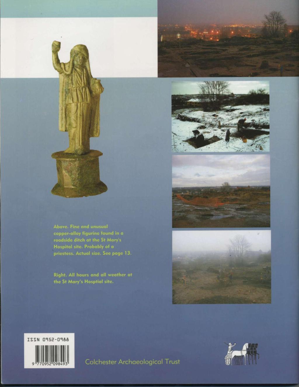
36
An archaeological watching brief and recording at Brightlingsea Quarry, Moverons Lane, Brightlingsea, Essex October 2003
 An archaeological watching brief and recording at Brightlingsea Quarry, Moverons Lane, Brightlingsea, Essex commissioned by Mineral Services Ltd on behalf of Alresford Sand & Ballast Co Ltd report prepared
An archaeological evaluation at 16 Seaview Road, Brightlingsea, Essex February 2004
 An archaeological evaluation at 16 Seaview Road, Brightlingsea, Essex February 2004 report prepared by Kate Orr on behalf of Highfield Homes NGR: TM 086 174 (c) CAT project ref.: 04/2b ECC HAMP group site
An archaeological evaluation in the playground of Colchester Royal Grammar School, Lexden Road, Colchester, Essex
 An archaeological evaluation in the playground of Colchester Royal Grammar School, Lexden Road, Colchester, Essex February 2002 on behalf of Roff Marsh Partnership CAT project code: 02/2c Colchester Museum
An archaeological evaluation at the Blackwater Hotel, Church Road, West Mersea, Colchester, Essex March 2003
 An archaeological evaluation at the Blackwater Hotel, Church Road, West Mersea, Colchester, Essex report prepared by Laura Pooley on behalf of Dolphin Developments (U.K) Ltd NGR: TM 0082 1259 CAT project
Colchester Archaeological Trust Ltd. A Fieldwalking Survey at Birch, Colchester for ARC Southern Ltd
 Colchester Archaeological Trust Ltd A Fieldwalking Survey at Birch, Colchester for ARC Southern Ltd November 1997 CONTENTS page Summary... 1 Background... 1 Methods... 1 Retrieval Policy... 2 Conditions...
An archaeological evaluation at the Lexden Wood Golf Club (Westhouse Farm), Lexden, Colchester, Essex
, Lexden, Colchester, Essex") An archaeological evaluation at the Lexden Wood Golf Club (Westhouse Farm), Lexden, Colchester, Essex January 2000 Archive report on behalf of Lexden Wood Golf Club Colchester Archaeological Trust 12 Lexden
An archaeological evaluation at the Lexden Wood Golf Club (Westhouse Farm), Lexden, Colchester, Essex January 2000 Archive report on behalf of Lexden Wood Golf Club Colchester Archaeological Trust 12 Lexden
An archaeological watching brief at Sheepen, Colchester, Essex November-December 2003
 An archaeological watching brief at Sheepen, Colchester, Essex November-December 2003 report prepared by Ben Holloway on behalf of Colchester Borough Council CAT project ref.: 03/11c Colchester Museums
Moray Archaeology For All Project
 School children learning how to identify finds. (Above) A flint tool found at Clarkly Hill. Copyright: Leanne Demay Moray Archaeology For All Project ational Museums Scotland have been excavating in Moray
Cambridge Archaeology Field Group. Fieldwalking on the Childerley Estate, Cambridgeshire. Autumn 2014 to Spring Third interim report
 Cambridge Archaeology Field Group Fieldwalking on the Childerley Estate, Cambridgeshire Autumn 2014 to Spring 2015 Third interim report Summary Field walking on the Childerley estate of Martin Jenkins
3. The new face of Bronze Age pottery Jacinta Kiely and Bruce Sutton
 3. The new face of Bronze Age pottery Jacinta Kiely and Bruce Sutton Illus. 1 Location map of Early Bronze Age site at Mitchelstown, Co. Cork (based on the Ordnance Survey Ireland map) A previously unknown
Cambridge Archaeology Field Group. Fieldwalking on the Childerley Estate Cambridgeshire
 Cambridge Archaeology Field Group Fieldwalking on the Childerley Estate Cambridgeshire 2009 to 2014 Summary Fieldwalking on the Childerley estate of Martin Jenkins and Family has revealed, up to March
7. Prehistoric features and an early medieval enclosure at Coonagh West, Co. Limerick Kate Taylor
 7. Prehistoric features and an early medieval enclosure at Coonagh West, Co. Limerick Kate Taylor Illus. 1 Location of the site in Coonagh West, Co. Limerick (based on the Ordnance Survey Ireland map)
Church of St Peter and St Paul, Great Missenden, Buckinghamshire
 Church of St Peter and St Paul, Great Missenden, Buckinghamshire An Archaeological Watching Brief for the Parish of Great Missenden by Andrew Taylor Thames Valley Archaeological Services Ltd Site Code
THE PRE-CONQUEST COFFINS FROM SWINEGATE AND 18 BACK SWINEGATE
 THE PRE-CONQUEST COFFINS FROM 12 18 SWINEGATE AND 18 BACK SWINEGATE An Insight Report By J.M. McComish York Archaeological Trust for Excavation and Research (2015) Contents 1. INTRODUCTION... 3 2. THE
Test-Pit 3: 31 Park Street (SK )
") -Pit 3: 31 Park Street (SK 40732 03178) -Pit 3 was excavated in a flower bed in the rear garden of 31 Park Street, on the northern side of the street and west of an alleyway leading to St Peter s Church,
-Pit 3: 31 Park Street (SK 40732 03178) -Pit 3 was excavated in a flower bed in the rear garden of 31 Park Street, on the northern side of the street and west of an alleyway leading to St Peter s Church,
Silwood Farm, Silwood Park, Cheapside Road, Ascot, Berkshire
 Silwood Farm, Silwood Park, Cheapside Road, Ascot, Berkshire An Archaeological Watching Brief For Imperial College London by Tim Dawson Thames Valley Archaeological Services Ltd Site Code SFA 09/10 April
Fieldwalking at Cottam 1994 (COT94F)
") Fieldwalking at Cottam 1994 (COT94F) Tony Austin & Elizabeth Jelley (19 Jan 29) 1. Introduction During the winter of 1994 students from the Department of Archaeology at the University of York undertook
Fieldwalking at Cottam 1994 (COT94F) Tony Austin & Elizabeth Jelley (19 Jan 29) 1. Introduction During the winter of 1994 students from the Department of Archaeology at the University of York undertook
Archaeological sites and find spots in the parish of Burghclere - SMR no. OS Grid Ref. Site Name Classification Period
 Archaeological sites and find spots in the parish of Burghclere - SMR no. OS Grid Ref. Site Name Classification Period SU45NE 1A SU46880 59200 Ridgemoor Farm Inhumation Burial At Ridgemoor Farm, on the
Chapter 2. Remains. Fig.17 Map of Krang Kor site
 Chapter 2. Remains Section 1. Overview of the Survey Area The survey began in January 2010 by exploring the site of the burial rootings based on information of the rooted burials that was brought to the
New Composting Centre, Ashgrove Farm, Ardley, Oxfordshire
 New Composting Centre, Ashgrove Farm, Ardley, Oxfordshire An Archaeological Watching Brief For Agrivert Limited by Andrew Weale Thames Valley Archaeological Services Ltd Site Code AFA 09/20 August 2009
ARCHAEOLOGICAL EVALUATION AT BRIGHTON POLYTECHNIC, NORTH FIELD SITE, VARLEY HALLS, COLDEAN LANE, BRIGHTON. by Ian Greig MA AIFA.
 ARCHAEOLOGICAL EVALUATION AT BRIGHTON POLYTECHNIC, NORTH FIELD SITE, VARLEY HALLS, COLDEAN LANE, BRIGHTON by Ian Greig MA AIFA May 1992 South Eastern Archaeological Services Field Archaeology Unit White
Grim s Ditch, Starveall Farm, Wootton, Woodstock, Oxfordshire
 Grim s Ditch, Starveall Farm, Wootton, Woodstock, Oxfordshire An Archaeological Recording Action For Empire Homes by Steve Ford Thames Valley Archaeological Services Ltd Site Code SFW06/118 November 2006
An archaeological evaluation by trial-trenching at Playgolf, Bakers Lane, Westhouse Farm, Colchester, Essex
 An archaeological evaluation by trial-trenching at Playgolf, Bakers Lane, Westhouse Farm, Colchester, Essex commissioned by Mr Stephen Belchem on behalf of ADP Ltd. report prepared by Chris Lister Planning
An archaeological watching brief on one section of an Anglian Water main Spring Lane, Lexden, Colchester
 An archaeological watching brief on one section of an Anglian Water main Spring Lane, Lexden, Colchester April-September 2001 on behalf of Breheny Contractors CAT project ref.: 01/4D Colchester Museum
An early pot made by the Adena Culture (800 B.C. - A.D. 100)
") Archaeologists identify the time period of man living in North America from about 1000 B.C. until about 700 A.D. as the Woodland Period. It is during this time that a new culture appeared and made important
Archaeologists identify the time period of man living in North America from about 1000 B.C. until about 700 A.D. as the Woodland Period. It is during this time that a new culture appeared and made important
Greater London GREATER LONDON 3/606 (E ) TQ
 TQ") GREATER LONDON City of London 3/606 (E.01.6024) TQ 30358150 1 PLOUGH PLACE, CITY OF LONDON An Archaeological Watching Brief at 1 Plough Place, City of London, London EC4 Butler, J London : Pre-Construct
GREATER LONDON City of London 3/606 (E.01.6024) TQ 30358150 1 PLOUGH PLACE, CITY OF LONDON An Archaeological Watching Brief at 1 Plough Place, City of London, London EC4 Butler, J London : Pre-Construct
Archaeological trial-trenching evaluation at Chappel Farm, Little Totham, Essex. April 2013
 Archaeological trial-trenching evaluation at Chappel Farm, Little Totham, Essex April 2013 report prepared by Ben Holloway commissioned by Tim Harbord Associates on behalf of Mr Tom Howie Planning reference:
Fort Arbeia and the Roman Empire in Britain 2012 FIELD REPORT
 Fort Arbeia and the Roman Empire in Britain 2012 FIELD REPORT Background Information Lead PI: Paul Bidwell Report completed by: Paul Bidwell Period Covered by this report: 17 June to 25 August 2012 Date
Essex Historic Environment Record/ Essex Archaeology and History
 Essex Historic Environment Record/ Essex Archaeology and History CAT Report 578 Summary sheet Address: Kingswode Hoe School, Sussex Road, Colchester, Essex Parish: Colchester NGR: TL 9835 2528 Type of
39, Walnut Tree Lane, Sudbury (SUY 073) Planning Application No. B/04/02019/FUL Archaeological Monitoring Report No. 2005/112 OASIS ID no.
 Planning Application No. B/04/02019/FUL Archaeological Monitoring Report No. 2005/112 OASIS ID no.") 39, Walnut Tree Lane, Sudbury (SUY 073) Planning Application No. B/04/02019/FUL Archaeological Monitoring Report No. 2005/112 OASIS ID no. 9273 Summary Sudbury, 39, Walnut Tree Lane, Sudbury (TL/869412;
39, Walnut Tree Lane, Sudbury (SUY 073) Planning Application No. B/04/02019/FUL Archaeological Monitoring Report No. 2005/112 OASIS ID no. 9273 Summary Sudbury, 39, Walnut Tree Lane, Sudbury (TL/869412;
Archaeological evaluation at the Onley Arms, The Street, Stisted, Essex
 Archaeological evaluation at the Onley Arms, The Street, Stisted, Essex November 2014 report by Pip Parmenter and Adam Wightman with a contribution from Stephen Benfield and illustrations by Emma Holloway
STONES OF STENNESS HISTORIC ENVIRONMENT SCOTLAND STATEMENT OF SIGNIFICANCE
 Property in Care (PIC) ID: PIC321 Designations: Scheduled Monument (SM90285); Taken into State care: 1906 (Guardianship) Last reviewed: 2003 HISTORIC ENVIRONMENT SCOTLAND STATEMENT OF SIGNIFICANCE STONES
ST PATRICK S CHAPEL, ST DAVIDS PEMBROKESHIRE 2015
 ST PATRICK S CHAPEL, ST DAVIDS PEMBROKESHIRE 2015 REPORT FOR THE NINEVEH CHARITABLE TRUST THE UNIVERSITY OF SHEFFIELD AND DYFED ARCHAEOLOGICAL TRUST Introduction ST PATRICK S CHAPEL, ST DAVIDS, PEMBROKESHIRE,
THE RAVENSTONE BEAKER
 DISCOVERY THE RAVENSTONE BEAKER K. J. FIELD The discovery of the Ravenstone Beaker (Plate Xa Fig. 1) was made by members of the Wolverton and District Archaeological Society engaged on a routine field
Bronze Age 2, BC
 Bronze Age 2,000-600 BC There may be continuity with the Neolithic period in the Early Bronze Age, with the harbour being used for seasonal grazing, and perhaps butchering and hide preparation. In the
Lanton Lithic Assessment
 Lanton Lithic Assessment Dr Clive Waddington ARS Ltd The section headings in the following assessment report refer to those in the Management of Archaeological Projects (HBMC 1991), Appendix 4. 1. FACTUAL
An archaeological evaluation at Thistle Hall, Mope Lane, Wickham Bishops, Essex July 2009
 An archaeological evaluation at Thistle Hall, Mope Lane, Wickham Bishops, Essex July 2009 report prepared by Howard Brooks and Ben Holloway on behalf of Clarity Ecoworks Ltd CAT project ref.: 09/1f ECC
BALNUARAN. of C LAVA. a prehistoric cemetery. A Visitors Guide to
 A Visitors Guide to BALNUARAN of C LAVA a prehistoric cemetery Milton of Clava Chapel (?) Cairn River Nairn Balnuaran of Clava is the site of an exceptionally wellpreserved group of prehistoric burial
SALVAGE EXCAVATIONS AT OLD DOWN FARM, EAST MEON
 Proc. Hants. Field Club Archaeol. Soc. 36, 1980, 153-160. 153 SALVAGE EXCAVATIONS AT OLD DOWN FARM, EAST MEON By RICHARD WHINNEY AND GEORGE WALKER INTRODUCTION The site was discovered by chance in December
A Sense of Place Tor Enclosures
 A Sense of Place Tor Enclosures Tor enclosures were built around six thousand years ago (4000 BC) in the early part of the Neolithic period. They are large enclosures defined by stony banks sited on hilltops
2 Saxon Way, Old Windsor, Berkshire
 2 Saxon Way, Old Windsor, Berkshire An Archaeological Watching Brief For Mrs J. McGillicuddy by Pamela Jenkins Thames Valley Archaeological Services Ltd Site Code SWO 05/67 August 2005 Summary Site name:
An archaeological watching brief at St Leonard s church, Hythe Hill, Colchester, Essex
 An archaeological watching brief at St Leonard s church, Hythe Hill, Colchester, Essex report prepared by Adam Wightman on behalf of Dorvell Construction CAT project ref.: 10/5d Colchester and Ipswich
Archaeological Material From Spa Ghyll Farm, Aldfield
 Archaeological Material From Spa Ghyll Farm, Aldfield Introduction Following discussions with Linda Smith the Rural Archaeologist for North Yorkshire County Council, Robert Morgan of 3D Archaeological
Cetamura Results
 Cetamura 2000 2006 Results A major project during the years 2000-2006 was the excavation to bedrock of two large and deep units located on an escarpment between Zone I and Zone II (fig. 1 and fig. 2);
The Living and the Dead
 The Living and the Dead Round Barrows and cairns The transition from the late Neolithic to the early Bronze Age is traditionally associated with an influx of immigrants to the British Isles from continental
16 members of the Fieldwalking Group met York Community Archaeologist Jon Kenny at Lou Howard s farm, Rose Cottage Farm, at
 Terrington History Group Fieldwalking Group Field 1 Final report 21 October 2011 - fieldwalking 16 members of the Fieldwalking Group met York Community Archaeologist Jon Kenny at Lou Howard s farm, Rose
PREHISTORIC ARTEFACT BOX
 PREHISTORIC ARTEFACT BOX PREHISTORIC ARTEFACT BOX: COMPLETE BOX 1 Antler Retoucheur 11 Leather Cup 2 Flint Retoucheur 12 Flint Scrapers [1 large & 4 x small] in pouch 3 Hammer Stone 13 Flint Arrowheads
THE UNFOLDING ARCHAEOLOGY OF CHELTENHAM
 THE UNFOLDING ARCHAEOLOGY OF CHELTENHAM The archaeology collection of Cheltenham Art Gallery & Museum contains a rich quantity of material relating to the prehistoric and Roman occupation of the North
St Germains, Tranent, East Lothian: the excavation of Early Bronze Age remains and Iron Age enclosed and unenclosed settlements
 Proc Soc Antiq Scot, 128 (1998), 203-254 St Germains, Tranent, East Lothian: the excavation of Early Bronze Age remains and Iron Age enclosed and unenclosed settlements Derek Alexander* & Trevor Watkinsf
Former Whitbread Training Centre Site, Abbey Street, Faversham, Kent Interim Archaeological Report Phase 1 November 2009
 Former Whitbread Training Centre Site, Abbey Street, Faversham, Kent Interim Archaeological Report Phase 1 November 2009 SWAT. Archaeology Swale and Thames Archaeological Survey Company School Farm Oast,
DEMARCATION OF THE STONE AGES.
 20 HAMPSHIRE FLINTS. DEMARCATION OF THE STONE AGES. BY W, DALE, F.S.A., F.G.S. (Read before the Anthropological Section of -the British Association for the advancement of Science, at Birmingham, September
LE CATILLON II HOARD. jerseyheritage.org Association of Jersey Charities, No. 161
 LE CATILLON II HOARD CELTIC TRIBES This is a picture of the tribal structure of the Celtic Society CELTIC TRIBES Can you see three different people in the picture and suggest what they do? Can you describe
Life and Death on a Romano-British estate: Turnershall Farm in Hertfordshire
 Introduction Life and Death on a Romano-British estate: Turnershall Farm in Hertfordshire In 2002 metal detectorists discovered two of the most significant burials to come from Roman Britain. The objects
Erection of wind turbine, Mains of Loanhead, Old Rayne, AB52 6SX
 Erection of wind turbine, Mains of Loanhead, Old Rayne, AB52 6SX Ltd 23 November 2011 Erection of wind turbine, Mains of Loanhead, Old Rayne, AB52 6SX CONTENTS 1 INTRODUCTION 3 2 ARCHAEOLOGICAL BACKGROUND
T so far, by any other ruins in southwestern New Mexico. However, as
 TWO MIMBRES RIVER RUINS By EDITHA L. WATSON HE ruins along the Mimbres river offer material for study unequaled, T so far, by any other ruins in southwestern New Mexico. However, as these sites are being
A Fieldwalking Project At Sompting. West Sussex
 by John Funnell Introduction A Fieldwalking Project At Sompting. West Sussex During March -and April 1995 the Brighton and Hove Archaeological Society conducted fie1dwa1king in a field at Sompting West
Evidence for the use of bronze mining tools in the Bronze Age copper mines on the Great Orme, Llandudno
 Evidence for the use of bronze mining tools in the Bronze Age copper mines on the Great Orme, Llandudno Background The possible use of bronze mining tools has been widely debated since the discovery of
Changing People Changing Landscapes: excavations at The Carrick, Midross, Loch Lomond Gavin MacGregor, University of Glasgow
 Changing People Changing Landscapes: excavations at The Carrick, Midross, Loch Lomond Gavin MacGregor, University of Glasgow Located approximately 40 kilometres to the south-west of Oban, as the crow flies
Peace Hall, Sydney Town Hall Results of Archaeological Program (Interim Report)
") Results of Archaeological Program (Interim Report) Background The proposed excavation of a services basement in the western half of the Peace Hall led to the archaeological investigation of the space in
Results of Archaeological Program (Interim Report) Background The proposed excavation of a services basement in the western half of the Peace Hall led to the archaeological investigation of the space in
Artifacts. Antler Tools
 Artifacts Artifacts are the things that people made and used. They give a view into the past and a glimpse of the ingenuity of the people who lived at a site. Artifacts from the Tchefuncte site give special
January report prepared by Laura Pooley, Ben Holloway, Philip Crummy and Rob Masefield. on behalf of Taylor Woodrow
 Assessment report on the archaeological investigations carried out on Areas C1, C2, E, J1, O, Q and S1 of the Alienated Land, Colchester Garrison, including the Time Team trenches and the Alienated Land
HANT3 FIELD CLUB AND ARCH^OLOGICAL SOCIETY, PLATE 4
 HANT3 FIELD CLUB AND ARCH^OLOGICAL SOCIETY, 1898. PLATE 4 VUU*. ilurti.14 HALF SIZE. BRONZE PALSTAVES, FOUND AT PEAR TREE GREEN. n BRONZE IMPLEMENTS FROM THE. NEIGHBOURHOOD OF SOUTHAMPTON, BY W. DALE,
Hembury Hillfort Lesson Resources. For Key Stage Two
 Hembury Hillfort Lesson Resources For Key Stage Two 1 Resource 1 Email 1 ARCHAEOLOGISTS NEEDED Dear Class, I recently moved to Payhembury and I have been having fun exploring the beautiful Blackdown Hills.
I MADE THE PROBLEM UP,
 This assignment will be due Thursday, Oct. 12 at 10:45 AM. It will be late and subject to the late penalties described in the syllabus after Friday, Oct. 13, at 10:45 AM. Complete submission of this assignment
STONE implements and pottery indicative of Late Neolithic settlement are known to
 Late Neolithic Site in the Extreme Northwest of the New Territories, Hong Kong Received 29 July 1966 T. N. CHIU* AND M. K. WOO** THE SITE STONE implements and pottery indicative of Late Neolithic settlement
To Gazetteer Introduction
 To Gazetteer Introduction Aylesford Belgic Cemetery - Grog-tempered 'Belgic' Pottery of South-eastern England AYLESFORD (K) TQ 727 594 Zone 4 It was in the publication of this cemetery that Evans (1890)
Teachers Pack
 Whitehorse Hill: A Prehistoric Dartmoor Discovery 13.09.14-13.12.14 Teachers Pack CONTENTS About the Teachers Pack 05 Introduction to the exhibition 05 Prehistoric Britain - Timeline 05 What changed? Technology,
Leeming to Barton Improvement
 Start of works exhibition March 2014 Welcome Introduction Following the public inquiry in November 2006, the Secretaries of State for Transport and Communities and Local Government announced the decision
Greater London Region GREATER LONDON 3/567 (E.01.K099) TQ BERMONDSEY STREET AND GIFCO BUILDING AND CAR PARK
 TQ BERMONDSEY STREET AND GIFCO BUILDING AND CAR PARK") GREATER LONDON 3/567 (E.01.K099) TQ 33307955 156-170 BERMONDSEY STREET AND GIFCO BUILDING AND CAR PARK Assessment of an Archaeological Excavation at 156-170 Bermondsey Street and GIFCO Building and Car
GREATER LONDON 3/567 (E.01.K099) TQ 33307955 156-170 BERMONDSEY STREET AND GIFCO BUILDING AND CAR PARK Assessment of an Archaeological Excavation at 156-170 Bermondsey Street and GIFCO Building and Car
A visit to the Wor Barrow 21 st November 2015
 A visit to the Wor Barrow 21 st November 2015 Following our exploration of Winkelbury a few weeks previously, we fast forwarded 12 years in Pitt Rivers remarkable series of excavations and followed him
Barnet Battlefield Survey
 In terim report on the progress of the Barnet Battlefield Survey December 2016 The Barnet Battlefield Survey is an archaeological investigation into the 1471 Battle of Barnet. It aims to define more accurately
The Upper Sabina Tiberina Project: Report for the Archaeological Institute of America Rutgers University Newark
 The Upper Sabina Tiberina Project: Report for the Archaeological Institute of America Rutgers University Newark My archeological dig took place near the village of Vacone, a small town on the outskirts
Archaeological. Monitoring & Recording Report. Fulbourn Primary School, Cambridgeshire. Archaeological Monitoring & Recording Report.
 Fulbourn Primary School, Cambridgeshire Archaeological Monitoring & Recording Report October 2014 Client: Cambridgeshire County Council OA East Report No: 1689 OASIS No: oxfordar3-192890 NGR: TL 5190 5613
The lithic assemblage from Kingsdale Head (KH09)
") 1 The lithic assemblage from Kingsdale Head (KH09) Hannah Russ Introduction During excavation the of potential Mesolithic features at Kingsdale Head in 2009 an assemblage of flint and chert artefacts were
1 The lithic assemblage from Kingsdale Head (KH09) Hannah Russ Introduction During excavation the of potential Mesolithic features at Kingsdale Head in 2009 an assemblage of flint and chert artefacts were
Report on archaeological fieldwalking and metal-detecting survey on land adjacent to Breck Farm, Stody, Norfolk
 Report on archaeological fieldwalking and metal-detecting survey on land adjacent to Breck Farm, Stody, Norfolk report prepared by Howard Brooks and Ben Holloway with contributions by Emma Spurgeon and
Excavations at Shikarpur, Gujarat
 Excavations at Shikarpur, Gujarat 2008-2009 The Department of Archaeology and Ancient History, the M. S. University of Baroda continued excavations at Shikarpur in the second field season in 2008-09. In
MARSTON MICHAEL FARLEY
 MARSTON MICHAEL FARLEY On 9 March agricultural contractors, laying field drains for Bucks County Council Land Agent's Department, cut through a limestone structure at SP 75852301 in an area otherwise consistently
SCOTLAND. Belfast IRISH SEA. Dublin THE REPUBLIC OF IRELAND ENGLAND ENGLISH CHANNEL. Before and After
 ALL ABOUT BRITAIN This book tells the story of the people who have lived in the British Isles, and is packed with fascinating facts and f un tales. The British Isles is a group of islands that consists
This is a repository copy of Anglo-Saxon settlements and archaeological visibility in the Yorkshire Wolds.
 This is a repository copy of Anglo-Saxon settlements and archaeological visibility in the Yorkshire Wolds. White Rose Research Online URL for this paper: http://eprints.whiterose.ac.uk/1172/ Book Section:
The first men who dug into Kent s Stonehenge
 From: Paul Tritton, Hon. Press Officer Email: paul.tritton@btinternet.com. Tel: 01622 741198 The first men who dug into Kent s Stonehenge Francis James Bennett (left) and a colleague at Coldrum Longbarrow
1 The East Oxford Archaeology and History Project
 1 The East Oxford Archaeology and History Project EXOP TEST PIT 72 Location: Bartlemas Chapel, Cowley Date of excavation: 6-8 November 2013. Area of excavation: 0.8m x 1.2m, at the eastern end of the chapel.
Suburban life in Roman Durnovaria
 Suburban life in Roman Durnovaria Additional specialist report Finds Ceramic building material By Kayt Brown Ceramic building material (CBM) Kayt Brown A total of 16420 fragments (926743g) of Roman ceramic
Human remains from Estark, Iran, 2017
 Bioarchaeology of the Near East, 11:84 89 (2017) Short fieldwork report Human remains from Estark, Iran, 2017 Arkadiusz Sołtysiak *1, Javad Hosseinzadeh 2, Mohsen Javeri 2, Agata Bebel 1 1 Department of
Archaeological Watching Brief (Phase 2) at Court Lodge Farm, Aldington, near Ashford, Kent December 2011
 at Court Lodge Farm, Aldington, near Ashford, Kent December 2011") Archaeological Watching Brief (Phase 2) at Court Lodge Farm, Aldington, near Ashford, Kent December 2011 SWAT. Archaeology Swale and Thames Archaeological Survey Company School Farm Oast, Graveney Road
Archaeological Watching Brief (Phase 2) at Court Lodge Farm, Aldington, near Ashford, Kent December 2011 SWAT. Archaeology Swale and Thames Archaeological Survey Company School Farm Oast, Graveney Road
FURTHER MIDDLE SAXON EVIDENCE AT COOK STREET, SOUTHAMPTON (SOU 567)
") Roc. Hampshire Field Club Archaeol. Soc 52,1997, 77-87 (Hampshire Studies 1997) FURTHER MIDDLE SAXON EVIDENCE AT COOK STREET, SOUTHAMPTON (SOU 567) By M F GARNER andj VINCENT with a contribution byjacqueline
Roc. Hampshire Field Club Archaeol. Soc 52,1997, 77-87 (Hampshire Studies 1997) FURTHER MIDDLE SAXON EVIDENCE AT COOK STREET, SOUTHAMPTON (SOU 567) By M F GARNER andj VINCENT with a contribution byjacqueline
A COIN OF OFFA FOUND IN A VIKING-AGE BURIAL AT VOSS, NORWAY. Bergen Museum.
 A COIN OF OFFA FOUND IN A VIKING-AGE BURIAL AT VOSS, NORWAY. BY HAAKON SCHETELIG, Doct. Phil., Curator of the Bergen Museum. Communicated by G. A. AUDEN, M.A., M.D., F.S.A. URING my excavations at Voss
(photograph courtesy Earle Seubert)
") THE ARCHAEOLOGY OF A CEMETERY THE TRIALS AND TRIBULATIONS OF FINDING THE LOST GRAVES OF WOODMAN POINT QUARANTINE STATION This presentation is about a project initiated by the Friends of Woodman Point and
THE ARCHAEOLOGY OF A CEMETERY THE TRIALS AND TRIBULATIONS OF FINDING THE LOST GRAVES OF WOODMAN POINT QUARANTINE STATION This presentation is about a project initiated by the Friends of Woodman Point and
Xian Tombs of the Qin Dynasty
 Xian Tombs of the Qin Dynasty By History.com, adapted by Newsela staff In 221 B.C., Qin Shi Huang became emperor of China, and started the Qin Dynasty. At this time, the area had just emerged from over
An archaeological watching brief and evaluation at Great Notley business park, near Braintree, Essex June-September 2005
 An archaeological watching brief and evaluation at Great Notley business park, near Braintree, Essex report prepared by Kate Orr commissioned by Andrew Martin Associates Ltd on behalf of Countryside Properties
An archaeological evaluation by trial-trenching at Scotts Farm, Lodge Lane, Purleigh, Essex October 2011
 An archaeological evaluation by trial-trenching at Scotts Farm, Lodge Lane, Purleigh, Essex October 2011 report prepared by Adam Wightman on behalf of Richard Emans CAT project ref.: 11/10a NGR: TL 582719
Advanced archaeology at the archive. Museum of London Support materials AS/A2 study day
 Advanced archaeology at the archive Support materials AS/A2 study day Contents National Curriculum links and session description 1-2 Example timetable 3 Practical guidelines 4 Visit preparation and pre-visit
Tell Shiyukh Tahtani (North Syria)
") Tell Shiyukh Tahtani (North Syria) Report of the 2010 excavation season conducted by the University of Palermo Euphrates Expedition by Gioacchino Falsone and Paola Sconzo In the summer 2010 the University
Tell Shiyukh Tahtani (North Syria) Report of the 2010 excavation season conducted by the University of Palermo Euphrates Expedition by Gioacchino Falsone and Paola Sconzo In the summer 2010 the University
Fieldwalk On Falmer Hill, Near Brighton - Second Season
 Fieldwalk On Falmer Hill, Near Brighton - Second Season by the Brighton and Hove Archaeological Society This report as well as describing the recent fieldwalks also includes descriptions of previous discoveries
STUDENT ACTIVITY SHEETS Lullingstone Roman Villa
 STUDENT ACTIVITY SHEETS Lullingstone Roman Villa This resource pack has been designed to help students step into the story of Lullingstone Roman Villa, which provides essential insight into the lives of
ARCHAEOLOGICAL MONITORING REPORT
 ARCHAEOLOGICAL MONITORING REPORT SCCAS REPORT No. 2009/324 Thorington Hall, Stoke by Nayland SBN 087 HER Information Date of Fieldwork: November 2009 - January 2010 Grid Reference: TM 0131 3546 Funding
The Vikings Begin. This October, step into the magical, mystical world of the early Vikings. By Dr. Marika Hedin
 This October, step into the magical, mystical world of the early Vikings The Vikings Begin By Dr. Marika Hedin Director of Gustavianum, Uppsala University Museum This richly adorned helmet from the 7th
THE EXCAVATION OF A BURNT MOUND AT HARBRIDGE, HAMPSHIRE
 Proc Hampshire Field ClubArchaeolSoc5i, 1999,172-179 (Hampshire Studies 1999) THE EXCAVATION OF A BURNT MOUND AT HARBRIDGE, HAMPSHIRE by S J SHENNAN ABSTRACT A burnt mound of Late Brome Age date, as indicated
The Jawan Chamber Tomb Adapted from a report by F.S. Vidal, Dammam, December 1953
 Figure 1 - The Jawan tomb as photographed from helicopter by Sgt. W. Seto, USAF, in May 1952 The Jawan Chamber Tomb Adapted from a report by F.S. Vidal, Dammam, December 1953 I. Description of work and
Latest archaeological finds at Must Farm provide a vivid picture of everyday life in the Bronze Age 14 July 2016
 Latest archaeological finds at Must Farm provide a vivid picture of everyday life in the Bronze Age 14 July 2016 Simplified schematic representation of a typical house at the Must farm settlement. The
Excavations of Late Iron Age and Roman features and a Roman road north of Gosbecks Archaeological Park, Colchester, Essex
 Excavations of Late Iron Age and Roman features and a Roman road north of Gosbecks Archaeological Park, Colchester, Essex 1995-1996 report by Stephen Benfield with contributions from Justine Bailey, Peter