List of Plates. Project Team. Executive Summary 7
|
|
|
- Wilfred Charles
- 5 years ago
- Views:
Transcription
1
2 AJ/CRDS Ltd 06E944ext. Laughanstown Job No. 679 Luas B1-Sandyford to Cherrywood List of Plates. Project Team iii v Executive Summary 7 1. Introduction Site Location The Nature of the Development Circumstances and Dates of Fieldwork 9 2. Geology and Topography Solid Geology and Soils Topography and Landscape Baseline Survey Introduction Recorded Archaeological Sites and Monuments Recorded Archaeological Finds Previous Excavations Cartographic Sources Historical Research Previous Archaeological Work Archaeological and Historical Background Prehistory (c BC - AD 500) Early Medieval Period (c. AD ) Late Medieval Period (c. AD ) Post Medieval Period to Early Modern Period (c. AD ) Excavation Results Introduction Methods Excavation Results Summary Stratigraphic Report Introduction Phase 1: Prehistoric Activity Phase 2: 17 th to 18 th Century Military Activity Phase 3: 18 th and 19 th Century Agricultural Activity Phase 4: Features of Unconfirmed Date Archaeological Finds Overview Metal Objects Lithics Glass Ceramic Archaeological Samples Soil Samples 31 May 2009 i Final Report
3 AJ/CRDS Ltd 06E944ext. Laughanstown Job No. 679 Luas B1-Sandyford to Cherrywood 8.2. Soil Sample Results Discussion The Archaeological Evidence Recommended Avoidance, Remedial or Reductive Measures 36 Bibliography 37 Appendices: Appendix 1: Recorded Monuments and Places within c. 500m of the Site Appendix 2: Recorded Archaeological Finds from the Vicinity of the Site Appendix 3: Previous Excavations Appendix 4: Feature Register Appendix 5: Finds Register Appendix 6: Small finds report Appendix 7: Prehistoric Pottery Report Appendix 8: Radiocarbon Dates Appendix 9: Lithics Report Appendix 10: Plant Macrofossil remains Appendix 11: Abridged Metal Detection Report Figures Plates May 2009 ii Final Report
4
5
6 AJ/CRDS Ltd 06E944ext. Laughanstown Job No. 679 Luas B1-Sandyford to Cherrywood Project Team Director: Project Manager: Post-Excavation Team: Post-Excavation Manager: Report Production: Editor: Historical Background: Illustrations: Photographs: Aaron Johnston David. J. O Connor Dave Marcus Ludovic Beaumont Milica Rajic Aaron Johnston Denis Shine Donal Fallon Madeline Parker Niall Lynch Catherine Bishop Aaron Johnston Excavation Team: Site Director: Site Supervisor: Site Supervisor: Site Supervisor: Surveyor: Safety Officer: Site Assistant: Site Assistant: Site Assistant: Site Assistant: Site Assistant: Site Assistant: General Operative: General Operative: Aaron Johnston Gianmarco Cattari Rachel Homan Richard Reid Ken Russell Bairbre Mullee Ludovic Beaumont Dave Marcus Larry Moran Zbigniew Wegielnik Andrzej Wojdak Christine Moore Warren Montgomery Aiveen Cleary May 2009 v Final Report
7 AJ/CRDS Ltd 06E944ext. Laughanstown Job No. 679 Luas B1-Sandyford to Cherrywood Project Pre-development Excavation Licence No. 06E944ext. Metal Detection Consent No. 06R178 Licensee Aaron Johnston Project Managers David. J. O Connor/Richard Clutterbuck Consultant Cultural Resource Development Services Ltd Archaeological and Historical Consultants Unit 4A, Dundrum Business Park, Dundrum Dublin 14 Client Railway Procurement Agency Project Luas B1, Sandyford to Cherrywood Extension CRDS Project No. 679 Townland Civil Parish County Laughanstown Tully South County Dublin. Nat. Grid Ref. NGR E, N Report Date May 2009 Report signed off by, Stephen Mandal - EurGeol; MIAI; PGeo Managing Director CRDS Ltd May 2009 vi Final Report
8 AJ/ CRDS Ltd 06E0944 ext. Laughanstown Job No. 679 Luas B1-Sandyford to Cherrywood Executive Summary On behalf of the Railway Procurement Agency (RPA), archaeological consultants CRDS Ltd have completed the following final report detailing results from fully resolved excavations at Laughanstown in South County Dublin. Pre-development excavations were undertaken in advance of the proposed Luas B1 Sandyford to Cherrywood extension. Further investigations, which comprised of a full resolution excavation followed on from initial archaeological testing in September 2006, which revealed several archaeologically significant features dating from the prehistoric to early modern period. The site was excavated between October and December 2006 under an extension to the existing licence (06E0944ext). In total, an area of c.1350m² was assessed. Excavation exposed three separate phases of archaeological remains dating to the following periods: prehistoric activity dated from the Late Neolithic through to the Iron Age period, (c. 2800BC to 400AD); probable 18 th century military activity associated with the nearby historic Laughlinstown/Laughanstown military camp and 18 th to 19 th century agricultural activity. The early modern Laughanstown/Loughlinstown military camp (DU026:127), is located c. 60m to the east from the site of excavation. Three main concentrations of prehistoric activity were exposed at various locations across the site during excavation. The northernmost group consisted of a concentration of 12 individual postholes, pits and stake holes centred on a shallow pit. Prehistoric pottery, dated to the Later Neolithic/Early Bronze as well as a range of flint scrapers and other flint artefacts were recovered from several of these features. A radiocarbon date of cal BC (2 sigma; Wk 24913) was retrieved from a single posthole. This group of features was exposed across an area of c. 25m 2 in the northern half of the site; although having no obvious overall structural outline, the individual features are presumed to have had a possible structural function and have been labelled for interpretative purposes as Structure A. The second group of features was exposed c. 40m to the south-east of those described above and consisted of 18 individual stakeholes and postholes, centred on two large pits. The two large pits, situated in the southern half of the site, were located only c. 0.30m apart and contained an amount of surface burnt material as well as evidence of in situ burning. A dolerite stone axe butt as well as a range of scrapers and flints and a single sherd of prehistoric pottery was recovered from these features. A pit within the features was dated to cal AD (2sigma; Wk 24914). Again no clear structural shape was evident but a structural function is still assumed. The feature group was named Structure B. The third concentration of possible prehistoric features was situated in the southern half of the site, located c. 8m to the north-east of Structure B. This group consisted of an irregular shaped pit and three small possible stakeholes. A struck flint was recovered from beside the pit. However, these features were not well defined or suggestive of any type of formal structure and hence were not interpreted as such. The two groups of features which have been tentatively interpreted as possible structures have deposits within two of the features dated by radiocarbon evidence to the later prehistoric period. A posthole within the group of features interpreted as Structure A appears to date to the later Bronze Age or Early Iron Age (1000 BC 400 AD). The uppermost deposit within the largest pit interpretaed as part of Structure B dates to the later end of the Iron Age (600 BC 400 AD). The dating evidence provided by radiocarbon appears to contradict the stratified pottery and flint assemblages which have been dated to the later Neolithic or Early Bronze Age ( BC). Evidence of crop cultivation and processing as well as small scale flint knapping was also recovered from the vicity of the possible structures. May Final Excavation Report
9 AJ/ CRDS Ltd 06E0944 ext. Laughanstown Job No. 679 Luas B1-Sandyford to Cherrywood The traces of the possible structures do not appear to represent an established or prolonged settlement.; However the evidence suggests the possibility of prehistoric human settlement in Laughanstown from the Late Neolithic through to the Late Iron Age. There was likely an initial temporary settlement in the later Neolithic or Early Bronze Age as represented by the pottery and lithic finds assemblage. A further temporary phase of settlement dated by radiocarbon as occurring at some point in the Later Bronze to Iron Age suggests multiple phases represented within the individual features comprising Structure A, and Structure B.. Tenuous structural evidence was exposed near the centre of the site, suggestive of possible foundations, for a timber framed dwelling. Significantly, a range of military artefacts such as buttons, badges, musket balls and lead waste as well as a number of tokens dating from the later 18 th century were recovered from the site as part of a metal detection program carried out in association to the excavations. This artefact assemblage gives a clear indication of the possible extent of the historic 18 th century Laughanstown/Loughlinstown military encampment and may suggest the building foundation features identified, as being of a similar date. May Final Excavation Report
10 AJ/ CRDS Ltd 06E0944 ext. Laughanstown Job No. 679 Luas B1-Sandyford to Cherrywood 1. Introduction 1.1. Site Location The site of excavation is located in the townland of Laughanstown, c. 1.5km to the south-east of Carrickmines and c. 1km north of Junction 16 on the M50 motorway, in the Dun Laoghaire-Rathdown area of South County Dublin (NGR E, N; Figure 1). Laughanstown (also known as Lehaunstown) is located in the civil parish of Tully and the Barony of Rathdown, and is situated c metres above sea level. The route of the proposed development is c. 60m to the west of the zone of archaeological potential for Laughanstown/Loughlinstown military camp (DU026:127) depicted on the Record of Monuments and Places. The remains of Tully church (DU026:023), an ecclesiastical site of early medieval origin are located c. 200m to the west The Nature of the Development The Railway Procurement Agency (RPA) submitted an application for a Railway Order to the Minister for Transport under Section 37 of the Transport (Railway Infrastructure) Act 2001 on 7 th November The Railway Order, subsequently granted by the Minister on 14 August 2006, authorised the RPA to provide for the construction, operation and maintenance of a light railway between Sandyford Industrial Estate and Cherrywood. The Railway Order became enforceable on 24 th January 2007 and the project is currently under construction. Luas B1 is a 7.6km extension to the existing Luas Green Line currently operating between St. Stephen s Green and Sandyford. The construction of the Luas track involves excavation of a trench at least 7m wide and 1.20m deep. The working width of the construction corridor measures c. 15m to 25m, with additional areas for temporary construction compounds Circumstances and Dates of Fieldwork Archaeological excavations under license (06E944ext.) took place between 18 th October and 8 th December 2006, along a section of the Luas development corridor, extending between Laughanstown Lane and Cherrywood Estate. The site was exposed by topsoil stripping using a tracked excavation machine to the upper limits of archaeological deposits and extended to the very edge of the development footprint. The site was located on a flat area of undeveloped pasture-land. The entire development footprint in the Laughanstown area measures c. 25m in width by 350m in length, comprising an area of c. 8750m 2. The total area which was of archaeological interest and excavated was c. 1350m 2. The archaeological team varied in number from one to eleven members and consisted of a director, three supervisors, six site assistants and two general operatives. May Final Excavation Report
11 AJ/ CRDS Ltd 06E0944 ext. Laughanstown Job No. 679 Luas B1-Sandyford to Cherrywood 2. Geology and Topography 2.1. Solid Geology and Soils The geology of the surrounding general area consisted of granite bedrock overlain by late Pleistocene glacial tills; mainly grey brown podzolic soils with frequent limestone fragments. The ground conditions along the route were heavily influenced by the last major glaciation, in which typically, between 1m and 20m of glacial till overlay the bedrock. The granite bedrock, when decayed, leads to acidic soils which create a poor environment for preservation of bone and faunal material. The soil sampling strategies during excavation took this fact into account. The site is located on an area of flat undeveloped pasture-contained within a large field which historically has been intensively cultivated Topography and Landscape Topographically, the landscape traversed by the proposed Luas B1 route through Laughanstown townland can be described as a low-lying river valley, located c. 2km from the coast at Dalkey Bay. The site is located on a flat area of pastureland. The land rises up to the south-west, along a ridge at 74 metres above sea level, upon which is located Tully Church. Otherwise the the land slopes gently down to the coast in the east. The site is c. 500m south of the Carrickmines stream; a tributary of the Loughlinstown River which is located c. 500m to the east of the site. The site has been under intensive agricultural cultivation for at least the last two centuries and the topsoil/ploughsoil layer is relatively deep. The surrounding area has been heavily developed over the past decade, particularly land aroundcherrywood and the M50 motorway. May Final Excavation Report
12 AJ/ CRDS Ltd 06E0944 ext. Laughanstown Job No. 679 Luas B1-Sandyford to Cherrywood 3. Baseline Survey 3.1. Introduction For the purpose of setting the proposed development within its wider archaeological and cultural heritage landscape, and to assess the archaeological potential of the site, a comprehensive paper survey of all available archaeological, historical and cartographic sources was undertaken. A study area of roughly 500m from the proposed works was applied and all townlands traversed by the proposed scheme were assessed Recorded Archaeological Sites and Monuments The Record of Monuments and Places was consulted for the relevant parts of County Dublin. This is a list of archaeological sites known to the National Monuments Service of the DoEHLG. The relevant files for these sites contain details of documentary sources and aerial photographs, early maps, OS memoirs, OPW Archaeological Survey notes and other relevant publications. These were studied in the Sites and Monuments Records Office. The monuments are listed in Appendix Recorded Archaeological Finds The topographical files in the National Museum of Ireland were consulted to determine if any archaeological artefacts had been recorded from the area. This is the national archive of all known finds recorded by the National Museum. It relates primarily to artefacts but also includes references to monuments and has a unique archive of records of previous excavations. Other published catalogues of prehistoric material were also studied: Raftery ( Iron Age antiquities), Eogan (1965; 1993; bronze swords, Bronze Age hoards and goldwork), Harbison (1968; 1969a; 1969b - bronze axes, halberds and daggers) and the Irish Stone Axe Project Database (Archaeology Dept., U.C.D.). All townlands within the study area were assessed. A list of recorded finds from the area is given in Appendix Previous Excavations The excavation bulletin website ( was consulted to identify previous excavations that may have been carried out within the study area. This database contains summary accounts of excavations carried out in Ireland from The available Excavations publications were also consulted. Details of previous excavations are listed in Appendix 3 and discussed in summary in the main body of this report Cartographic Sources Reference to cartographic sources is important in tracing land use development within the study area as well as providing important topographical information on sites and areas of archaeological potential. Primary cartographic sources consulted consisted of the Ordnance Survey 6" maps, first and later editions (T.C.D. Map Library). Earlier cartographic sources consisted of the Down Survey map of the Barony of Rathdown (c. 1656), Taylor s map of the Environs of Dublin (1816) Historical Research Primary historical sources consulted included The Civil Survey for the County of Dublin (Simington 1945). Secondary sources included Francis Elrington Ball s Loughlinstown and its History (1901), Murray s article Laughlinstown camp (1944) and Leo Swan s Lehaunstown Park, Co. Dublin: A Forgotten Tower House. May Final Excavation Report
13 AJ/ CRDS Ltd 06E0944 ext. Laughanstown Job No. 679 Luas B1-Sandyford to Cherrywood 3.7. Previous Archaeological Work A number of archaeological studies have been carried out since 1994 in the townland of Laughanstown, including those in advance of the construction of the M50 Dublin, South-Eastern Motorway located c. 1km south of the proposed development, which revealed a number of archaeological sites within this area. Full details of these excavations are given in Appendix 3. Environmental Impact Statement prepared by Margaret Gowen, incorporating the results archaeological test excavations (Simpson, 94E201). Archaeological monitoring in advance of a housing development across an extensive area in Laughanstown (O'Donovan, 97E0279). Test excavation in advance of road-building for the Southern Cross Motorway (Grant 98E026). Archaeological excavation of a number of sites in advance of the construction of a Bord Gáis Éireann pipeline in September-November 1998 (O Néill, 98E0445). Archaeological testing in advance of the South-Eastern Motorway (Desmond, 00E0085). Archaeological excavation at Site 28 Laughanstown in advance of the South-Eastern Motorway. This area was utilised as an 18 th century army camp (Desmond, 00E0880). An area of 16,157m 2 was monitored in Site 28 on the South-Eastern Motorway (Seaver, 00E0880 ext.). Historical records have revealed that a large 18th-century army encampment was located in Laughanstown, Co. Dublin. Six test-trenches were hand-dug in order to identify the encampment area (Lynch, 00E0880). The site is located in Laughanstown to the immediate north of Desmond s excavation 00E0085, listed above. Five test-trenches were excavated in an attempt to date a stone structure associated with the tower-house known as Lehaunstown House. (Desmond, 00E0100). Thirteen known sites were identified within the Laughanstown/Glebe complex as a result of a comprehensive archaeological assessment process, which included geophysics survey, topographical survey, aerial survey and archaeological test excavation, as part of the South- Eastern Motorway. The sites were excavated between 2000 and 2002 (Seaver, 00E0283). This site in Laughanstown was discovered during monitoring on the South-Eastern Motorway. Amongst other features uncovered was a ditch which was possibly a boundary ditch dating to the medieval period (Conboy, 02E1131). This site in Laughanstown was excavated before the rerouting of a water main required by the construction of the South-Eastern Motorway. All of the sites were on the edge of a large marshy basin that runs down to the Shanganagh River and marks the end of the rocky upland. Artefacts and features dating from the prehistoric to the post-medieval period were uncovered (Seaver, 02E1133). May Final Excavation Report
14 AJ/ CRDS Ltd 06E0944 ext. Laughanstown Job No. 679 Luas B1-Sandyford to Cherrywood Monitoring of groundworks associated with a proposed communications development site in the townland of Laughanstown, Co. Dublin, (O'Neill, 03E0210). The programme of testing was determined by a geophysical survey undertaken by GSB in In order to establish the veracity of these results, eight test-trenches were opened mechanically over three areas of positive anomalies to the top of possible archaeological features. No datable artefacts were recovered during the testing programme (Baker, 03E0910). Monitoring of groundworks associated with the development of the Science and Technology Park (II) and district lands in Cherrywood and Laughanstown (McQuade, 03E E1182, 03E1365, 03E1366, 03E0839, 03E1370). Archaeological Section of EIS, Luas Line B1, Area 15: Ballyogan Wood to Brides Glen, Co. Dublin Margaret Gowen & Co. Ltd 2005 Unpublished report prepared for the Railway Procurement Agency. Archaeo-geophysical Survey at Laughanstown: Licence No. 06R069. Elliot, I.S Unpublished Report CRDS Ltd. Dublin. 4. Archaeological and Historical Background 4.1. Prehistory (c BC - AD 500) Previous archaeological investigations are the most substantial source of information for prehistoric activity in the townland of Laughanstown. Excavations producing significant amounts of prehistoric material have been undertaken by O Donovan for Margaret Gowen Ltd, who uncovered evidence dating from the Neolithic to the Bronze Age (O Donovan 97E0279 see Appendix 3) and by Matthew Seaver for Valerie J. Keely Ltd (Seaver, 00E0880 ext.; 00E0283; 02E1133 see Appendix 3). This latter series of investigations took place in advance of the construction of the M50 Motorway c. 1km south of the current site; it revealed a range of sites and artefacts dating from the Neolithic/Mesolithic? through to the 18 th century (Seaver 2001, 8-10; Seaver 2004, 8-12). Topographical, geophysical and aerial survey associated with this investigation identified thirteen potential new sites, including four possible ring-ditches, an oval banked enclosure, a number of low mounds and platforms and a possible large trivallate enclosure some of which were the subject of further investigations (Seaver 2001, 8). Finally, McQuade also discovered evidence of a range of prehistoric sites dating from the Bronze and Iron Ages on Cherrywood/Laughanstown excavations conducted in 2003 (McQuade 03E0839, 03E1145, 03E1182, 03E1365, 03E1366, 03E1370, 03E147 see Appendix 3). The most important findings from these investigations are summarised below; the full excavation bulletins are transcribed in Appendix 3. Seaver s excavations, which took place c. 0.75km-1km to the south and southwest of the current site recovered limited evidence for Mesolithic activity in the townland of Laughanstown, consisting of a microlith and a small number of blades. Evidence from the Neolithic was more extensive. A range of Neolithic artefacts were recovered, including broken and complete stone axes, concave and hollow scrapers, leaf-shaped arrow heads, blades, cores and potsherds (Seaver 00E0880 ext.; 00E0283; 02E1133; Seaver 2004, 9-10 see Appendix 3). At an earlier series of excavations in the townlands of Cherrywood and Laughanstown, O Donovan found several archaeological features and artefacts, including some quern fragments, which may represent a Neolithic presence in the area, suggestive of a habitation site (O Donovan; 97E0279 see Appendix 3). May Final Excavation Report
15 AJ/ CRDS Ltd 06E0944 ext. Laughanstown Job No. 679 Luas B1-Sandyford to Cherrywood Evidence from the Early Bronze Age and the remainder of the prehistoric period is more extensive. The heavily disturbed remains of an Early Bronze Age wedge tomb (DU026:024, See Appendix 1) are located c.700m south of the current site; this consists of a roughly oval mound or cairn made of local granite and quartz. There is evidence of a U-shaped kerb around this feature, which appears to have originally opened to the west. It now survives only partially to the south and more extensively to the north where twelve stones form a straight-sided, 60cm high kerb (Corlett 1999, 107). Seaver s excavations of the wedge tomb indicated that it was defined by a low earthen bank, capped with a ring of stones. A resistivity survey indicated a large trivallate enclosure may be located directly underneath the wedge tomb. Seaver suggested that the earthworks surrounding the tomb may indicate its importance not only as a depositional site for human remains, but also as a place of ritual significance (Seaver 2001, 10). Seaver s investigations identified several other prehistoric features and recovered a range of artefacts of Bronze Age date in the broader vicinity of the wedge-tomb. The evidence, when combined, appears to indicate an intensification of land use in the vicinity of the tomb in the Middle to Late Bronze Age (Seaver 2004, 10-11). Approximately 65m south-east of the wedge tomb a scatter of post-holes and a hearth were identified. The hearth contained pottery in the Beaker and the Vase traditions. A number of disc scrapers were also recovered from this site. South of the tomb an unenclosed settlement was excavated and the analysis of the grain which was found yielded a date of cal. B.C. A range of archaeological features were identified in the vicinity of the tomb including a cairn, the remains of a quarried cairn, burnt mounds, pits, a rock outcrop which shows significant signs of quarrying, various banks. A range of artefacts were also recovered from these sites and the immediate vicinity of the tomb including pottery sherds, flint implements, scrapers, blades, hammerstones, a porphyry axe, a stone spindle-whorl, a large portion of a saddle quern stone built into a drystone wall, a cup-marked stone, a polished dolerite axe, and human remains (Seaver 2001, 9-10; Seaver 2004, 10-12). McQuade discovered evidence of a range of similar prehistoric sites dating from the Bronze through to the Iron Age including a cremation urn, pits, burnt mounds and other associated features at a series of excavations which took place at a distance of between c.300m -1.25km south of the subject site (McQuade 03E0839, 03E1365, 03E1370 see Appendix 3) Early Medieval Period (c. AD ) One of the earliest recorded monument from this period is a ringfort marked on the 1 st Edition Ordnance Survey map of 1837 located c. 400m southwest of the current development (DU026:006). There are estimated to be between 30,000 and 40,000 known examples of ringforts in Ireland making them one of the most prominent monument types in the landscape (Power et al. 1992, 131). In its simplest form a ringfort is essentially a circular space surrounded by a bank and fosse or simply by a rampart of stone. While they vary considerably in size, they are generally considered to have been enclosed farmsteads, some may even have simply functioned as cattle enclosures. Their defensive capacity is generally considered to have been of secondary importance (Stout 1997, 14, 32-34). Stout describes Leinster as an area of low ringfort density. It has been suggested that ringforts may have been gradually destroyed through intensive tillage in areas with a long history of Anglo-Norman settlement. They would also have been less likely to have been continuously constructed and maintained in such areas, as they were traditionally associated with native Irish settlement. Alternatively, it is likely that the Anglo-Normans established centres of settlement in areas which were less densely populated by ringforts when they arrived. Consequently, it may be argued that the Irish living in this region possibly favoured other types of settlement patterns over the ringfort system used elsewhere (Stout 1997, 59-63). Despite this latter consideration, it is generally accepted that surviving May Final Excavation Report
16 AJ/ CRDS Ltd 06E0944 ext. Laughanstown Job No. 679 Luas B1-Sandyford to Cherrywood ringforts in this area are unlikely to represent the monument s original numbers and are therefore not an accurate representation of the early medieval settlement density. A second ringfort, located on the boundary between the townlands of Laughanstown and Glebe, was excavated during archaeological works carried out in advance of the construction of the M50. The ringfort had an internal diameter of 46m. It was accompanied by a number of associated features and deposits, including an infant burial. Among the most significant finds from the site were a number of inscribed bones; one was inscribed with the word Deo and a chi-rho symbol, suggesting a knowledge of church manuscripts (Seaver 2004, 11). One of the most important recorded monuments in Laughanstown is a small, ruined church known as Tully Church, located c. 285m south of the excavation site (DU026:023, see Appendix 1). It is dedicated to, and is said to have been founded by St Brigid, possibly indicating that it may date to the early 6 th century. The first historical reference to the church was made in 1179 when it was recorded that it had previously been granted to the Priory of the Holy Trinity and was called Tullaghnanepscop, meaning Hill of the Bishops. Joyce argues that the name originates from a legend in which several holy men embarked from this establishment on a journey to visit St. Brigid (Joyce 1912, 74; Deery and Halpin ). A charter of King John s confirming the priory s possessions in 1202, lists Sighrahre, son of Thorkill as the original grantor, ceding lands centred on Laughanstown, an area between Carrickmines and Loughlinstown, to the priory before the Norman invasion (Ball 1995, 103; O Byrne 2003, 230). The church appears to have been extended in the 11 th or 12 th century and is contained within two concentric enclosures. Investigations undertaken by O Donovan in 1998 uncovered a section of the boundary ditch associated with the outer enclosure (O Donovan, 97E0279). Amongst the numerous crosses and cross slabs in and around the church is a 12 th century cross located to the north of the graveyard which possibly marked the outer boundary of the tearmann, the sacred area around the church. Three stone crosses dating to between the eighth and eleventh centuries, and two of the Rathdown leacs (or decorated cross slabs) are located near the church. Tully Church was ruined in 1615 and despite repairs in 1630, it fell out of use altogether after the 1641 Rebellion (Deery and Halpin 2005, 53). Archaeological evidence indicates that the area around Laughanstown was used for cereal cultivation in the early medieval period. Seaver s excavations (see Seaver 2001 & Seaver 2004) uncovered a number of medieval artefacts in the plough soils, including a number of plough pebbles and local pottery, the latter of which would have been deposited when the long fields were manured during this period. Seaver also identified a number of furrows and field drains which provide further evidence for early medieval agriculture (Seaver 2001, 8-12). Finally, four earth-cut cereal kilns and a series of postholes representing a structure were also uncovered. The kilns contained oats, wheat and barley and along with the structure and evidence for the presence of field hedges indicate large-scale crop growth and processing at the site in the medieval period (Seaver 2004, 11) Late Medieval Period (c. AD ) Sources indicate that Laughanstown and the surrounding area was part of a small manor during the medieval period. It was probably administered from a farm centre on the site presently occupied by Laughanstown Park House (Seaver 2001, 9). For most of the 12 th century the most prominent Ostmen of Ui Briuin Chualann and the owners of Carrickmines were the Meic Torcaill, who were the kings of Dublin, which of course included the parish of Tully in which the study area is located (O Byrne 2003, 230). May Final Excavation Report
17 AJ/ CRDS Ltd 06E0944 ext. Laughanstown Job No. 679 Luas B1-Sandyford to Cherrywood The end of the Torcaill kings reign came in 1171 when they were dispossessed of their lands after the arrival of the Anglo-Normans (O Byrne 2003, 235). After the Norman arrival the area under their control was known as the Pale and the area outside it was known as the March. Laughanstown is located just outside the Pale and was a disputed marchland between the 13 th and 16 th centuries. The Welsh and Anglo-Normans who settled in the region were subject to frequent attacks from the native O Byrnes and the O Tooles of Wicklow (O Byrne 2003, ). For much of the first half of the 14 th century Maurice Howel was retained by the Crown to act as guardian of the Leinster Marches from the stronghold of Carrickmines Castle, the remains of which are located c. 1km to the west of the current development. This castle was central to the defence of the region and its colonists. Despite Howel s efforts, much of the area was laid waste by O Byrne raids and continual refortification was required to defend against such attacks throughout the fourteenth century. By 1388 the castle was housing a standing cavalry force which carried out punitive raids into the lands of the Wicklow tribes. By 1400, Carrickmines and many other possessions of the Howel family passed into the possession of the Walsh family, who held the castle until the 17 th Century (O Byrne 2003, ). Near Tully Church stood a second castle, known as Lehaunstown castle, which was marked on the Down Survey Barony map of 1655 (DU026:093). This castle, and its immediate surrounds were described by the Civil Survey of as a Castle Thatcht, and a small grove of shrubby wood (Simington 1945, 276). The castle was leased by the powerful Ostman family of Archbold, whose land was flanked by the Walshs of Carrickmines, and the Goodmans of Loughlinstown, all of whom had settled the land to protect the southern barriers of the Pale (Swan 1998, 165). In 1566 the Archbolds sided with the native Irish and turned on the English government and were dispossessed of their lands, which were granted to John Graham. The remains of this castle survive as the core of the present private dwelling at Lehaunstown House, consisting of a small rectangular building measuring 9.5m by 6.5m, with extremely thick walls (Swan 1998, 165) Post Medieval Period to Early Modern Period (c. AD ) During the rebellion of 1641 many of the old English lords of the Pale sided with the native Irish and by the end of that year the whole of south Dublin was under rebel control (Goodbody 1993, 34). At this time, Lehaunstown Castle was attacked and burnt by the rebels Robert Barnewall of Shankill and James Goodman of Loughlinstown as it had become the refuge place for the vicar of Rathmichael, Rev. Simon Swayne and his companions (Ball 1902, 96). The list of garrisons in the Marquis of Ormonde s regiment in August of 1642 included Lehaunstown and Kilgobbin castles, which were under the command of Colonel Monck. After the rebellion was eventually extinguished by Cromwell in 1649, most of these castles were confiscated by the British government because of the owner s involvement in the rebellion (Goodbody 1993, 34-35). Despite all this conflict, at the time of the restoration a good thatched castle was recorded to have stood in Laughanstown and was occupied by Edward Buller, whose tomb is still extant in Stillorgan Churchyard (Ball 1995, 104). In 1690, during the Williamite wars, the army of James II camped at Laughanstown. The original camp appears to have been centred on a hill to the north of Tully Church, which subsequently became known as Gun and Drum Hill. King James is reputed to have spent the night in Puck s Castle near Rathmichael (Deery and Halpin 2005, 48). The second, more extensive and important military camp was established in Laughanstown by the British government in The camp was set up to defend Killiney Bay from a possible French landing (Seaver 2004, 12) and was later used as a garrison during the 1798 rebellion. The first occupiers of this late 18 th century camp were the Westmeath militia, the Drogheda militia and the May Final Excavation Report
18 AJ/ CRDS Ltd 06E0944 ext. Laughanstown Job No. 679 Luas B1-Sandyford to Cherrywood Scottish Perthshire fencibles. At its peak the military camp covered over 120 acres and billeted up to 4000 troops in Laughanstown (Deery and Halpin 2005, 48). This later camp had two lines of encampment. The first was located on the original site of Gun and Drum Hill, but probably extended further south towards the current development, while the second was probably located to the east, on a line west of and parallel to the current N11.The camp was said to have been a sight unparalleled in Ireland at the time (Ball 1902, 104). Despite the original plan to stay in tents for the summer and then move on, extensive use was made of wooden houses, or army huts, which were unusual for 1795 and signified a much more permanent arrangement. In 1796 Ferrar, who described the camp as novel for the times, explained the layout of the encampment as follows: On the first and second lines are sixty-four wooden houses, each containing thirty-six privates and two non-commissioned officers. On the third line are the captains and subalterns houses, in some of which three are quartered in distinct apartments; and on the fourth are the staff, to the rear of which are mess-houses and kitchens, with the quarter-guard in front, making in all 125 houses The wooden houses were pitched, canvasses and made waterproof The entire length of the line from right to left is one-third of a mile, which is gravelled fortyfive feet in breadth. and is the centre of a grand parade. This somewhat luxurious camp came complete with a ballroom and coffee room which supplied Irish and foreign newspapers and hosted public breakfasts. The camp was finally dismantled and its troops moved elsewhere at the close of the eighteenth century (Ferrar 1796; Deery and Halpin 2005, 48). A communication route, which soldiers probably used for field manoeuvres, may have run across the site to Bride s Glen. A route connecting to Bride s Glen is shown on Rocque s map of 1760 (Seaver 2001, 9). The site of the military camp has been the subject of archaeological investigations which have identified associated archaeological remains and recovered a range of significant artefacts. Excavations carried out in Cherrywood, Laughanstown and Loughlinstown by O Donovan in (97E0279; Appendix 3) produced large quantities of eighteenth century material associated with both an inn and the military fort. Matthew Seaver s excavations in Laughanstown recovered a range of military artefacts from the eighteenth century including musket shots, gunflint, badges and buttons bearing the insignia of the Louth Militia and a number of Scottish regiments, coins of George III and commercial tokens from the Associated Irish Mines Company of Kyan and Camac. Seaver explains that such tokens would have been used as payment to the soldiers so that they could purchase goods at the weekly markets which took place at the camp (Seaver ; Seaver 2004, 8-12). The section of the current development corridor which is the subject of this report passes c. 60m southwest of the historic army camp site, (DU026:127) as depicted on the RMP maps. May Final Excavation Report
19 AJ/ CRDS Ltd 06E0944 ext. Laughanstown Job No. 679 Luas B1-Sandyford to Cherrywood 5. Excavation Results 5.1. Introduction Archaeological excavation was undertaken to investigate and resolve the complex of archaeological features exposed during pre-development testing in Laughanstown, (06E944, Fallon 2006). After consultation with the National Monuments Section of the Department of the Environment, Heritage and Local Government and the National Museum of Ireland, excavation proceeded under an extension to the existing testing licence (06E944ext.). Due to the proximity of the site of Laughanstown army camp, listed in the Record of Monuments and Places (DU026:127), the license was granted on condition that all topsoil stripped from the site be subject to archaeological metal detecting. A licence for metal detecting was sought and granted (06R178, Johnston 2007; see Appendix 11). The excavation was carried out over a period of eight weeks from 18 October The site was divided into northern and southern sections by a narrow dividing baulk extending east-west across the centre of the site. This baulk followed the line of a large concrete sewage pipe running directly east to west. The total area stripped during the excavation phase was c. 1350m 2. The site measured c. 62m in length and 21m in width, with an average topsoil depth of between 0.60m to 0.70m Methods The site was carefully soil stripped to the upper level of archaeological deposits, using a three tonne mechanical digger and dumper over a period of several weeks. The size of machinery on site was severely restricted by height guidelines specified by the ESB due to the presence of 38kw power-lines running overhead, across the site of excavation. A roughly rectangular site area was stripped to the extent of the development footprint. A site grid was then established and linked to Ordnance Datum before the entire site was cleaned by hand and photographed. All the features deemed to be of archaeological significance were completely excavated after being fully recorded. Where investigation indicated features were of apparent natural origin no further work was undertaken. Each archaeological feature on site was recorded using a system of consecutive feature numbers assigned to each separate event recognised during excavation. These features: deposits/cuts/fills, were fully recorded with descriptions, plans and photographs. A total of 213 numbers were used for recording purposes. For ease of reference, cuts are labelled in [ square ] brackets, fills and deposits are labelled in ( curved ) brackets. A full feature register is contained in Appendix 4. This describes all features in detail including their composition, shape, dating, associations and interpretation. A Harris Matrix is included as Figure 11, giving the stratigraphic sequence of the site Excavation Results Summary The archaeological features recorded during the excavation, have been grouped into interpretative phases. This is based, both on the stratigraphic sequencing on site, as well as the recovery of artefacts and dates from the soil samples. Where finds or other dating material were not present, the features have been classified as of unknown date, unless they were in close proximity with a group of securely dated features, in which case an associated similar date has been suggested. May Final Excavation Report
20 AJ/ CRDS Ltd 06E0944 ext. Laughanstown Job No. 679 Luas B1-Sandyford to Cherrywood Prehistoric activity was recorded across the site with archaeological features comprising of possible pits, post-holes and stake-holes, some of which contained small sherds of prehistoric pottery, stone and flint tools. The finds can be divided into two different categories; those recovered from stratified contexts within fills or deposits and those likely to be residual finds in later deposits. There is a higher probability that finds recovered from the primary fills of a cut were deposited at the time of, or shortly after, its use or creation; these may be used to suggest a date for the feature. Conversely, where finds are recovered from the exposed surface of a feature, for instance the tertiary fill of a pit, or where a range of finds of varying date are recovered from the same context, they are generally of limited use in dating the feature s use or creation. The features exposed have been provisionally grouped into four phases (see Figure 5). Phase 1 Phase 2 Phase 3 Phase 4 Consisted of three specific areas of prehistoric activity; generally dated by the artefacts recovered within or nearby the concentrations of features.. The prehistoric features consisted of an irregular collection of shallow postholes, stakeholes, pits and a possible hearth concentrated in three localised areas. The most obvious features exposed during the excavation are two large pits [F43 and F50] dated to the prehistoric period. The uppermost fill (F45) of pit [F50] has been dated by radiocarbon to cal AD (2sigma; Wk24914); placing it within the Later Iron Age (Appendix 8). The fill (F40) of a pit/posthole [F41], associated with Structure A, has been dated by radiocarbon to cal BC (2sigma, Wk24913) suggesting a date between the Later Bronze Age and Early Iron Age. The pottery and lithic assemblage would suggest a date from the Late Neolithic to Early Bronze Age (2800BC 1500BC). The difference in date between the finds assemblage recovered and radiocarbon suggest that there may have been several phases of periodic prehistoric human activity. The limited pits and associated features exposed across the site of excavation may represent traces of temporary settlements such as a small campsite. Consisted of several features interpreted as the remains of a timber structurepossibly associated with the temporary occupation of the nearby 18 th century Laughanstown/Loughlinstown military encampment. The features consisted of five small rectangular foundation trenches and possible post-pad which contained compacted angular granite fragments, a notched granite slab and an iron bar; it is suggested these may have functioned as crude post-pads, supporting army tents or ancillary buildings. Consisted of a number of shallow linear cuts which are thought to represent the remains of ridge and furrow cultivation. The furrows are orientated roughly parallel with the existing field boundary located to the south of the excavated area, running northeast to south-west. No dateable evidence was recovered from these features and their outline has been seriously disturbed through root activity and subsequent agricultural activity. However previous excavations in the townlands of Glebe and Laughanstown exposed similar examples of ridge and furrow agriculture dated to the 18 th - 19 th Century, (Seaver 2000, 101; Seaver 2002, 173). Encompassed a range of features which contained no dateable evidence and therefore could not be placed within the three interpretive phases described above. These sterile and generally undiagnostic features were not situated in close enough proximity to the archaeological features containing datable evidence and so an associated or similar date could therefore not be suggested. May Final Excavation Report
21 AJ/ CRDS Ltd 06E0944 ext. Laughanstown Job No. 679 Luas B1-Sandyford to Cherrywood 6. Stratigraphic Report 6.1. Introduction Following the return of specialist reports regarding analysis of finds reports soil samples, and radiocarbon dating, three distinct phases were evident on the site. A fourth notional phase was assigned to r features of unconfirmed date (Figure 5). Phase 1. Phase 2. Phase 3. Phase 4. Prehistoric; Late Neolithic to Iron Age activity. 17 th - 18 th Century (military?) activity. 18 th - 19 th Century (agricultural?) activity. Unidentified features. Not dated Phase 1: Prehistoric Activity. A number of artefacts with a potential Late Neolithic to Early Bronze Age (2800BC to 1500BC), date were recovered from several archaeological features across the site. Where these artefacts were recovered from secure contexts, a corresponding date is suggested for that feature. However, the date of the artefacts does not correspond with the radiocarbon dates for the site which may indicate that the features grouped as Structure A and Structure B could in fact represent multiple, periodic phases of prehistoric human activity. Alternatively, the artefacts may have been disturbed and possibly redeposited after initial deposition, which tends to be suggested by the abraded and fragmentary state of the ceramic assemblage (Appendix 7). The distribution of prehistoric finds across the site corresponded with the location of two main concentrations of features; one group in the northern half of the site labelled Structure A (Figure 6), and a second group c. 40m to the south-east, labelled Structure B (Figure 7). These interpretative groupings covered a collection of shallow pits, post-holes and stake-holes, which may represent the traces of temporary structures. One radiocarbon date was retrieved from both of these structures; one for both Structure A and Structure B Structure A The features grouped under the label Structure A consisted of six possible stake-holes, [F19, F17, F15, F33, F7 and F41], three possible postholes [F5, F23, and F25] and three small possible pits [F49, F13, and F21]. These features were grouped together due to spaitial proximity, morphylogy,similar fill types and the stakeholes were of generally similar dimensions. All of these spatially associated features seemed to be centred on a single small pit [F13], (Figures 6, 8) and (Plates 3, 4). When initially exposed during testing,the pit was unfortunately slightly truncated by the machine test trench; however the original shape in plan appears to have been broadly oval. The maximum excavated dimensions of the truncated pit were, 1.70m in length, 0.60m in width, and 0.23m in depth. This fairly shallow pit contained two fills (F12 and F26). The only dateable finds were recovered from the primary fill (F12) and included two sherds of prehistoric pottery (06E944ext:12:5, 06E944ext:12:6), two flint blades (06E944ext:12:1, 06E944ext:12:2) as well as a flint spall and a flint chunk (06E944ext:12:3, 06E944ext:12:4) (Appendix 9). In addition to these artefacts any features within the group which contained charcoal were heavily sampled. A radiocarbon date of cal BC (2sigma; Wk 24913); was retrieved for the fill of a nearby stakehole [F41]; placing the formation of the stakehole at some point from the Later Bronze Age to Early Iron Age (Appendix 8). This contradiction in dates with the Neolithic or Early Bronze Age pottery and lithics recovered from the surrounding features within interpretative Structural Group A suggests either that stakehole [F41] represents a later intrusive feature, cutting into an earlier structure, or that the artefact assemblage recovered from nearby pit [F13] has somehow become redeposited during a later period of human activity.(appendix 7 and 9). May Final Excavation Report
22 AJ/ CRDS Ltd 06E0944 ext. Laughanstown Job No. 679 Luas B1-Sandyford to Cherrywood The other features concentrated within this c. 25m 2 area, apparently centred on pit [F13], have been provisionally assigned a similar date through proximity and morphology and therefore a contemporary association is suggested.. Six possible stakeholes, [F19, F17, F15, F33, F7 and F41], were located in close proximity, directly to the north-west and south-east, of pit [F13] (Figure 6). The stakeholes were roughly similar in size and profile and ranged in diameter from 0.1m to 0.2m and in depth from 0.07m to 0.25m; all six contained a single, generally similar indistinguishable fill type, except stakehole [F41]which contained far more charcoal inclusions, was larger and generally better defined (Figure 8). Three possible postholes [F5, F23, and F25], were also exposed immediately adjacent to the central pit [F13]. These ranged in diameter from 0.11m to 0.62m, and in depth from 0.13m to 0.21m. All the possible postholes were broadly similar in plan and profile; all three contained a similar fill type (Figures 6 & 8). Two other small pits [F49, and F21] were exposed in this area, located in close proximity to the northwest and south-east of pit [F13] respectively (Figure 6). The first [F49], was oval in plan and relatively shallow, with moderately sloping edges and contained only one sterile fill (F48), with maximum dimensions of 1.48m length, 1.1m width and 0.20m depth. The second pit [F21] was oval shaped, with fairly steep edges on the southern side, and a base which sloped gradually up to the northern side, measured 0.83m length, 0.60m width and 0.27m depth and contained two fills (F20 and F39) with charcoal flecks present within the upper pit fill (F20) (Figure 8). Several of the features grouped together as part of Structure A, contained small inclusions of charcoal within the soil matrix. Charcoal flecks were visible within the fills of four stakeholes [F7, F15, F17 F41] (described above) exposed in the immediate vicinity of the central pit [F13]. Charcoal inclusions were also visible within the primary fill (F12) of pit [F13], in addition to two sherds of prehistoric pottery. This suggests that all the features identified in the pit s immediate vicinity are associated and contemporary with the use of the central pit itself, although no source of in situ burning was located nearby. Unfortunately the flecksof charcoal scattered throughout the feature within Structure A were extremely small, only one suitable sample for a radiocarbon date was retrieved from aforementioned stakehole [F41] Structure B The features grouped together and labelled Structure B were concentrated in an area of c. 30m 2 within the southern half of the site (Figure 5). They consisted of two large pits [F43, F50], one small shallow pit [F90], two possible post-holes [F143, F84], and ten possible stake-holes [F87, F176, F135, F145, F147, F149, F151, F154, F155, and F162]. The feature was centred on the two large adjacent subrectangular pits [F43 and F50] (Figure 7). The largest pit [F50] within the feature group, appeared to have truncated a shallow broader pit [F90]; but this distinction was visible only in section (Figure 9). The maximum dimensions of this earlier pit were c. 1m in diameter and 0.33m in depth. A small flint blade (06E944ext:54:1; Appendix 9) was recovered from its single, fairly sterile fill (F54). The overall outline in plan of the shallow possible pit [F90] had been largely truncated by that of the larger pit [F50] (Figures 7 & 9). Pit [F50], the larger pit feature within Structure B, was sub-rectangular in shape with maximum dimensions of 3.58m in length, 1.57m in width and 0.70m in depth. It contained eight different fills (F45, F51, F53, F94, F91, F89, F88, F85) and two possible re-cuts [F92 and F93], but the nature of the soil made it difficult to definitely distinguish between most of the fills. Five sections were excavated and recorded within the pit (Figure 9). The pit [F50] has three episodes. The primary fills (F53, F85), the May Final Excavation Report
23 AJ/ CRDS Ltd 06E0944 ext. Laughanstown Job No. 679 Luas B1-Sandyford to Cherrywood secondary fills (F51, F88, F91) and the tertiary fill (F45, F89, F94). The primary fill (F53) was fairly sterile and contained a single small flint chunk (06E944ext:53:1; Appendix 9). The secondary fill (F51) contained a possible pounder or butt end of a dolerite stone axe (06E944ext:51:2; Appendix 9) and a flint core (06E944ext:51:1). One of the tertiary or upper fills (F45) contained burnt bone fragments, frequent amounts of charcoal flecks, and a small rubbing stone (06E944ext:45:1). This fill appears to be rake-out material derived from the lighting of fires in the nearby pit [F43]. Soil samples were obtained from the three most distinctive fills, (F51, F53, and F45) for scientific dating. However, only the uppermost fill (F45) was suitable for radiocarbon dating. Unfortunately the uppermost fill cannot be used to give a reliable date for the creation of the pit feature. The upper fill of pit [F50] was dated to cal AD (2sigma; Wk24914); suggesting the period of deposition within the central feature of Structure B dates to the later Iron Age. Again a similar situation to that in evidence within Structure A, where the radiocarbon date tends to contradict that of the artefacts recovered from Structure B which generally suggests a Later Neolithic date. This again, may be evidence of multiple periodic occupation throughout the prehistoric, Iron Age activity disturbing and Late Neolithic/Early Bronze Age material and features on the same site. A second smaller pit [F43] was exposed immediately adjacent to the west of pit [F50], described above. This was also sub-rectangular in shape, with maximum dimensions of 3.10m in length, 1.41m in width and 0.45m in depth (Figures 7 & 10). This pit contained three fills (F144, F46 and F42). Both the primary and secondary fills (F144, F46) were relatively sterile, with no charcoal inclusions and no finds recovered within. However the tertiary fill (F42) contained a circular flat slab of granite. The granite slab measured 0.42m in diameter and 0.10m thickness. A circular ring of fire-reddened clay containing charcoal flecks, surrounded the granite slab, providing firm evidence of in situ burning. The granite slab appeared to have been deliberately placed and used as a hearthstone or fireplace. Of particular note, are the association between the two uppermost fills (F42 & F45) within both adjacent large pits; the burnt material, charcoal and small fragments of a possible crucible artefact (F45) dated to cal AD (2sigma; Wk24914) and the hearthstone with in situ burning (F42) which would appear to be related and may suggest some type of Later Iron Age industrial activity was centred on the two large pits. The environmental analysis also noted that the uppermost fill (F45) in pit [F50] was rich in macrofosiil remains, including charred wheat chaff and barley grains, suggesting possible domestic activity such as cooking was also occurring at the hearthstone. Ten possible stakeholes [F87, F176, F135, F145, F147, F149, F151, F154, F155, F162] orientated in a single line, roughly north-south, were exposed adjacent to and within the two large pits [F43, F50] (Figures 7 & 10). The stakeholes ranged in diameter from 0.08m to 0.21m and in depth from 0.09m to 0.6m. All of the stakeholes contained only one fill and seemed to be of broadly similar size. The stakeholes may represent the remains of a temporary wooden fence, barrier or windbreak, possibly associated with the use of the nearby hearth (F42). The location of the stakeholes [F87] and [F176] could suggest that these features are either unrelated to the othersor that the fence-line was constructed and demolished during an episode of site use prior to the construction and use of pit [F43]. Two of the stakeholes [F87 and F176] were located within the larger pit [F50] and sealed by its upper fills. In addition a possible posthole [F84] was exposed at the base of this pit (Figure 7). The stratigraphic relationship was unfortunately unclear, as the posthole only became visible after the excavation of the pit was completed. The possible posthole was roughly sub-circular in shape with a fairly sterile fill, maximum dimensions of 0.30m in length, 0.24m in width and 0.14m in depth. May Final Excavation Report
24 AJ/ CRDS Ltd 06E0944 ext. Laughanstown Job No. 679 Luas B1-Sandyford to Cherrywood Another small possible post-hole [F143] was exposed 0.6m to the northeast of pit (F50), (Figure 7). This was sub-circular in plan with maximum dimensions of 0.66m in length, 0.5m in width and 0.13m in depth. It contained a single fill (F44); two sherds of prehistoric pottery (06E944ext:44:1, 06E944ext:44:2), were recovered from within. This pottery is similar to most of the other sherds recovered from the site, generally being undiagnostic but datable to the Late Neolithic to Early Bronze Age (Appendix 7). Other evidence of possible prehistoric activity associated with Structure B, included a shallow irregular deposit of mid brown sandy silt (F105) measuring 2m in length 0.42m in width and 0.16m in depth (Figure 5). This deposit occupied a shallow hollow in the natural subsoil c. 2m to the north of pit [F50]. Two sherds of prehistoric pottery, (06E944ext:105:1, 06E944ext:105:2) were recovered from within. Although difficult to identify these two sherds could possibly be grooved ware; a later Neolithic pottery type. The range of flint and stone finds, which were recovered from the larger pit [F50] have been provisionally dated to the Late Neolithic to Early Bronze. In addition to the stratified finds recovered, a total of 24 flint artefacts and pottery sherds of prehistoric date were recovered during the initial clean back of an area of c. 25m 2 area centred on Structure B; these were assigned a separate context number (F52) (Appendix 5, 7 & 9) Other features of possible Prehistoric date A third concentration of features exposed c. 8m to the north of Structure B, were considered too limited and ill-defined to clearly indicate a structural original. These features were centred on an irregular shaped pit [F190] 1.30m wide, 1.75m long and 0.39m deep (Plate 11). Three small possible stakeholes [F209, F210 and F182] were exposed at the base of this cut. These ranged in diameter from 0.08 to 0.3m and in depth from 0.12m to 0.18m; their fills were similar and were assigned a single number. A small patch of in situ burning was visible in the northern face of the pit cut, suggesting a possible association with the hearth or fireplace at the centre of Structure B. The pit contained two fills (F164, F189) No artefacts were recovered from within; a prehistoric date has been suggested due to the general similarities of the features to those in Structure B. The fills (F164, F189) were sampled; however, no samples for suitable for scientific dating. A shallow depression was exposed abutting the southern edge of pit [F90] described above. This measured 0.4m in width 1.05m in length and 0.05m in depth. It contained a single fill (F180); a small flint pebble; possibly split (06E944ext:180:1; Appendix 9) was recovered from within, suggesting a prehistoric date for the adjacent pit [F190] and the stakeholes within. A large shallow pit [F69] was exposed c. 15m northwest of feature group, Structure A. The pit was subcircular in shape, measuring 1.4m in width, 2m in length and 0.2m in depth. The pit contained a single fill (F68); four flint chunks and a flint flake showing evidence of retouching (06E944ext:68:1, 06E944ext:68:2, 06E944ext:68:3, 06E944ext:68:4, 06E944ext:68:5; Appendix 9) were recovered from within, indicating a likely prehistoric date and suggesting possible human activity in the immediate vicinity. However the pit was spatially isolated from the other possible prehistoric features exposed onsite. During the metal detection survey (06R178, Johnston 2007; Appendix 11); 143 flints, 32 of which, may be prehistoric in date, were recovered from topsoil and disturbed contexts within both the area of excavation and the broader development corridor. The impacts of agriculture and quarrying can be assumed to have caused extensive disturbance to underlying deposits, possibly removing the flints May Final Excavation Report
25 AJ/ CRDS Ltd 06E0944 ext. Laughanstown Job No. 679 Luas B1-Sandyford to Cherrywood some distance from their original context. However the quantity of flint artefacts recovered would still indicate a range of localized human settlement activity throughoutthe general area during the prehistoric period Phase 2: 17 th to 18 th Century Military Activity. Five features were identified in the southern half of the site which appeared to have no obvious agricultural function, (F61 F74, F75, F76 and F166) (Figure 5). Finds recovered from within these features and their immediate vicinity suggested a modern date. It is suggested that these features may have been related to the early modern 18 th century Laughanstown/Loughlinstown army camp (DU026:127) and may have functioned as possible post-pads, foundation trenches, or post-pits. These features are thought to be broadly contemporary, and have been labelled Phase Two. A possible wall foundation, (F74) and an adjacent post-hole [104], were exposed in the middle of the site, partially under the extant north-east to south-west orientated, excavation baulk. The features were both visible in full profile, directly under the upper topsoil layer (F2), initially suggesting a modern date. The wall foundation consisted of frequent small, angular granite stone fragments, compacted and apparently deliberately set within a shallow linear trench [F98]; the trench had maximum dimensions of 1.90m in length, 1.35m in width and 0.24m in depth. A small number of brick fragments and a single large rectangular granite block were recovered from amid the stone fragments; the granite block (Plate: 12), measured 1m long, 0.34 wide and 0.17m thick, a series of six notches or possible tool marks can be viewed along one edge. The deposit measured 1.45m long, 0.7m wide and 0.33m deep. A small shallow possible post/pit [F104] was exposed c. 0.20m, to the north of the wall foundation described above; it consisted of a sub- circular cut [F104] with maximum dimensions of 0.7m in length, 0.5m in width and 0.25m in depth. It contained a single fill (F76), with occasional fragments of red brick, similar to those recovered from the wall foundation (F74). Another possible post pit [F63] was exposed c. 3m to the west. It consisted of a shallow sub-rectangular cut measuring 0.41m wide, 0.98m long and 0.1m deep. It contained a single fill (F61), consisting of brownish grey sandy silt with frequent charcoal inclusions; several sherds of modern cream-ware (06E944ext:61:1-3) were recovered within. This pottery type dates typically from the later 18 th to 19 th century. A small shallow sub-circular cut [F101] was exposed c. 4m to the south of the wall foundation described above. It measured 0.94m in length, 0.8m in width and 0.14m in depth. This possible postpad contained a fill (F75) consisting of compacted granite stone. A number of glass bottle fragments were recovered from within which appear to have come form the same brown, glass 18 th 19 th century wine bottle (Appendix 6). A very similar feature was exposed, c. 15m to the south-east. This consisted of a sub-circular cut [F171] 0.6m in maximum diameter and 0.22m in depth. It contained a single fill (F166) consisting of small fragments of granite stone. Three corroded nails were recovered from within. These fairly modern features have been interpreted as possible elements of a structure\s associated with the nearby 18 th century Laughanstown/Loughlinstown military encampment. The circular pits [F171 and F101] and which conatin compacted stone appear to represent possible post-pads, deliberately created as a bases or plinths for posts by packing stone into a shallow pit; probably to support a timber structure. The available descriptions suggest the military camps in this area between 1690 and 1799 would have contained a range of both temporary and permanent structures, ranging from tents to substantial timber buildings: The wooden houses were pitched, canvassed and made waterproof. Ferrar (1796) May Final Excavation Report
26 AJ/ CRDS Ltd 06E0944 ext. Laughanstown Job No. 679 Luas B1-Sandyford to Cherrywood A ditch, a bank and other vague depressions in the landscape are located c. 60m to the east of the excavated site. These earthworks, apparently traces left over from the construction of the old Harcourt street railway line ( ) appear to be marked on the maps of the Record of Monuments and Places as the western boundary of the zone of archaeological potential for the Laughanstown Military camp. The precise extent of either the 17 th century or 18 th century camps is uncertain; the Record of Monuments and Places maps employ the line of the abandoned railway cutting, 60m east of the current site, as a notional western boundary, but there is no reason to suppose activity associated with the camp did not extend beyond this western boundary. The finds recovered from the metal detection survey (06R178 Johnston 2007; Appendix 6 & 10) included a range of military artefacts (tokens, buttons and musket-balls and other military paraphernalia) dating from the end of the 18 th century, which presumably are connected with historic military activity at the nearby Laughanstown/Loughlinstown army camp. Intensive agriculture across this area seems to have effectively spread the artefacts throughout the topsoil and also may have erased much of the evidence associated with the army camp, particularly considering that many of the structures would not have had substantial foundations. It seems possible that the traces of foundation trenches, pits and post-pads described above may have represented buildings dating from this period. No buildings are depicted within the site location on either the 1 st Edition Ordnance Survey map (surveyed 1837) or on the 3 rd Edition Ordnance Survey map (surveyed 1909); if the features exposed are of structural origin those structures would appear to have passed out of existence before Phase 3: 18 th and 19 th Century Agricultural Activity. Three shallow linear cuts [F9, F56, and F57], exposed along the north-western edge of the excavation area, may represent the impacts of early modern 18 th and 19 th century agriculture (Figure 5); the features are orientated northeast-southwest, broadly matching the orientation of the adjacent field boundaries. These linear cuts ranged in width from 0.7m to 0.8m and in depth from 0.3m to 0.4m. The outline of these agricultural furrows [F9, F56, and F57], have been subject to extensive disturbance by tree-roots [F196, F199, and F201], and later agricultural activity. No dateable finds were recovered from any of the furrow features. Similar types of agricultural features dated to around 18 th to 19 th century have been excavated in the general locality, by Matt Seaver (00E0283; 02E1133) and Melanie McQuade (03E0839), (Appendix 3). These agricultural features are generally classed as being of limited archaeological significance. A stone-lined drain (F38) was exposed extending northeast-southwest across the centre of the site, parallel to the furrows described above. Occasional plough-marks were also visible cut into the natural sub-soil at various places across the site. Further evidence of agricultural activity was recovered during metal detection of the topsoil under license (06R178, Johnston 2007; Appendix 11): several plough blades and other agricultural implements were found. The collective evidence from excavation and metal detection indicates that the landscape around the site has had a long history of cultivation and was under tillage up until relatively recently Phase 4: Features of Unconfirmed Date A total of 35 features, for which no provisional date or origin could be assigned were exposed during excavation. No diagnostic or dateable finds were recovered from within and the features were not immediately proximate to any features which could be assigned a date. It was impossible in most cases to determine whether these features were natural or represented human activity. Without any dateable evidence, interpretation is extremely difficult. The unidentified/undated features have been grouped May Final Excavation Report
27 AJ/ CRDS Ltd 06E0944 ext. Laughanstown Job No. 679 Luas B1-Sandyford to Cherrywood together for the purposes of description; because of their uncertain origin and date they have only been described briefly (Figure 5). A collection of six small, sub-circular features, [F167, F173, F177, F178, F183, and F185] were exposed in the southern half of the site. It is possible that some, may be the remains of post-holes; no finds were recovered and no distinctive inclusions were identified in their fills which would suggest a link with other features. The possible posthole cuts ranged in approximate diameter c. 0.16m to 0.76m and in depth from c. 0.1m to 0.32m. This grouping of possible postholes were located, c. 5m east of Structure B, which has been dated by artefacts and scientific dating to the prehistoric period; however it is not thought that these features are associated with Structure B. Some of the possible postholes [F167, F185] contained stones which may have been used to support wooden timbers with possibly [F183] representing a central structural post-hole. It is suggested that these six features may represent traces of a possible structure, but there is no definite evidence to support this view. A large deposit of loose stone (F161) was exposed abutting the southern limit of the excavation area. The deposit measuring 3m in width, 8m in length and 0.28m in depth, consisted of a mix of granite cobbles and smaller stone. Four finds of modern date were recovered from within: three corroded ferrous nails and a single sherd of black-ware. It is possible that this deposit is debris from 19 th century quarrying activity with a gravel pit depicted north of Tully Church and south of the site on the 1 st Edition OS Map, 1843 (Figure 2). A range of other features were exposed in the southern half of the site (F47), [F62, F67, F128, F125, F134, F120, F140, F129, F123, F121, F131, F117, F116, F80, F187, F82, F111, F114, F165, F109, F194, F207] (see Figure 5). All were relatively shallow and the majority were irregular in plan and profile. They ranged in size from 0.33m to 0.48m length, 0.13m to 0.48m width and 0.05m to 0.20m depth. No finds were recovered from within and their fills contained no archaeologically significant inclusions. Their shape and profile was generally too irregular to postulate a structural function and no meaningful grouping or alignment could be identified to suggest a common structural origin. A large granite boulder (F36) was exposed near the northern edge of the site; situated in a large pit [F37], 3m long by 2.2m wide and 0.4m deep; perhaps the stone was buried because it obstructed ploughing of this area or it may simply represent a glacial erratic (Plate 1). Various modern ceramics dating to the 18 th or 19 th century were recovered from this feature along with possible prehistoric pottery (06E944ext:36:30) suggesting residual mixed artefacts. Topsoil (F2) contamination of the fill of this pit is likely therefore and this feature is interpreted as being of no archaeological significance. May Final Excavation Report
28 AJ/ CRDS Ltd 06E0944 ext. Laughanstown Job No. 679 Luas B1-Sandyford to Cherrywood 7. Archaeological Finds 7.1. Overview A total of 518 finds were recovered and retained during the metal detection survey, testing and excavation at the Laughanstown site. A total of 130 of these were recovered during the course of the excavation with the rest being noted during the course of the metal detection survey 06R178. All of the finds from metal detection were recovered primarily from unstratified topsoil (F2), which was removed by machine during testing and excavation in Laughanstown (06E944ext.). All finds are listed in full in the site finds register (Appendix 5). An analysis of the finds is presented in Appendices 6, 7 and 9. The assemblage consists of prehistoric and post-medieval pottery, glass and flint artefacts, as well as ferrous and non-ferrous finds. The finds are classified according to their type (material from which they were made) and analysed as such. The recovered finds consisted of: 262 metal objects of which 206 were ferrous and 56 were non ferrous 209 lithic artefacts comprising 204 pieces of flint, 1 piece of quartz and 4 pieces of coarse stone 10 sherds of glass 36 ceramic artefacts comprising of 13 prehistoric pottery sherds, 18 post medieval sherds, 4 clay pipes and 1 crucible (in two fragments). Of the 514 finds, 308 consisting of the ferrous objects, glass and pottery were sent to a specialist (Ms. Milica Rajic) to confirm identifications and date (Appendix 6). The 206 lithics were submitted to Mr. Dermot Moore for analysis (Appendix 9). The thirteen prehistoric pottery sherds were submitted Ms. Catherine Dunne (Appendix 7) Metal Objects In total 262 metal objects were recovered during the metal detection survey and subsequent excavation. These consisted of 206 ferrous and 56 non ferrous items. Most of the ferrous objects were heavily encrusted and corroded, however it was still possible to identify most of them based on their shape. These items were nearly all considered to be modern (AD ) in date and of limited archaeological significance. The majority of the ferrous finds (185) were recovered from the metal detection of the topsoil (Appendix 11). They consisted of nails, horseshoe fragments, hooks, rivets, bolts, discs, iron sheets, plough fragments, a spanner as well as a range of unidentified encrusted objects. A full list and description of these objects is given in the preliminary site finds register in Appendix 5. A total 56 non ferrous items were also recovered. These consisted of: 7 tokens (including 3 conder tokens; 2 Parys Mine Company and 2 unidentified tokens) 1 coin (a George III copper half penny c ). 5 Buttons (two displaying the Kilkenny Regiment) 2 badges (possibly related to the Scottish Perthshire Fencibles) 15 musket shots (all recovered from the topsoil) 6 amorphous lead objects (recovered from the topsoil and probably associated to lead melting) May Final Excavation Report
29 AJ/ CRDS Ltd 06E0944 ext. Laughanstown Job No. 679 Luas B1-Sandyford to Cherrywood 17 miscellaneous copper alloy objects including a lock, keyhole, chain, hinge, fork and harmonica reed plate as well as other unidentified objects. Of the seven tokens recovered from the site 3 were Conder Tokens (06E944ext:2:10; 06E944ext:2:120; 06E944ext:2:124). These tokens are named after James Conder, an 18 th century cataloguer of the thousands of token types in circulation in the 18 th century. Tokens originated due to the failure of sovereign coinage to deal with increased demand. This was exacerbated by the industrial revolution which required large amounts of small value copper coinage to pay wages. The manufacture and circulation of token currency was outlawed in 1797 when the British Crown resolved the problem by circulating the new one and two penny copper coins. One of the conder tokens recovered during excavation was a Camac, Kyan and Camac Halfpenny Token. The token originated in Dublin and dates to The Camac Kyan and Camac tokens were issued by The Hibernian Mine Company, which was started in 1790 and incorporated by Act of Parliament in The partners at the time of the token s issue were Turner Camac, John Howard Kyan and John Camac. The other two Conder tokens are Cronebane copper halfpenny tokens which originated in Wicklow and date to These tokens were issued by Parys Mine Company at the end of the 18 th century. The wear on the remaining tokens made it impossible to give a date or provenance although a lion and a fleur de lis was visible on one (06E994ext:2:10; Appendix 6). A single coin was recovered during the investigations. This was a copper half penny dating to the reign of King George III ( ) which were circulated from The coin was heavily corroded and very little of the detail was evident. Five buttons and two cap badges were also recovered. Three of the buttons were heavily encrusted and no details are visible; however two small buttons have a visible design: harp in centre encircled with writing KILKENNY REGIMENT. The two badges are tin-plated cap badges in the shape of a folded feather and may be related to the Scottish Perthshire Fencibles (06E944ext:2:106; Appendix 6). Fifteen musket shots were also recovered during metal detection and excavation; all in the sites topsoil (06E944ext:2:82; 06E944ext:2:87; 06E944ext:2:119; 06E944ext:2:121; 06E944ext:2:136; 06E944ext:2:157; 06E944ext:2:158; 06E944ext:2:159; 06E944ext:2:160; 06E944ext:2:179; 06E944ext:2:180; 06E944ext:2:190; 06E944ext:2:191; 06E944ext:2:216; 06E944ext:2:217). These were in addition to six amorphous lead objects which are probably waste lead as a result of making lead musket shot. A variety of copper alloy finds were also noted including a thimble (06E944ext:2:80, a small padlock (06E944ext:2:76), a fragment of a keyhole (06E944ext:2:79), a fragment of a chain (06E944ext:2:78), a hinge (06E944ext:2:50), a fork (06E944ext:2:193) and various unidentified objects including two fragments of a possible harmonica reed-plate. All these finds are post medieval in date Lithics In total 209 lithic artefacts comprising 204 pieces of flint, 1 piece of quartz and 4 pieces of coarse stone were recovered; 66 during the excavation and 140 metal detection of the stripped topsoil. These have all been inspected by Mr. Dermot Moore (Appendix 9). The majority of this collection has been identified as not been particularly diagnostic with most of the finds been fashioned out of glacial drift pebbles. The finds probably represent later Neolithic activity continuing into the Early Bronze Age. The only clearly diagnostic find was a dolerite stone axe which dates to the middle to later Neolithic (Find No. 06E944ext:51:2). May Final Excavation Report
30 AJ/ CRDS Ltd 06E0944 ext. Laughanstown Job No. 679 Luas B1-Sandyford to Cherrywood The largest number of lithic finds were recovered from the topsoil (F2) and consisted of two flint pebbles, a crude indeterminate core with at least two flake scars, an irregular flint core portion with evident flake scars and two flint flakes. Also recovered were a large number of flint chunks, numbering 123 in total, some of which are natural, and three flint spalls as well as a dolerite and quartzite pebble (Appendix 9). Only a single secondary worked piece was recovered from the topsoil; a small crude flint scraper (06E0944:2:245). In addition two irregular flint pebbles, five irregular split pebble flint flakes and an irregular spall of greybuff flint derived from core working were noted in the ploughsoil (F8) which was recorded separately to the topsoil. The majority of the secure finds were recovered from features associated to Structure A and Structure B. Structure A: A possible flint blade and a flint flake (06E944ext:12:1, 06E944ext:12:2) were recovered from (F12) the fill of pit [F13]. Two flint debitage fragments (06E944ext:12:3, 06E944ext:12:4) were recovered from the fill of this pit which is at the centre of the group of features termed Structure A. Structure B: Recovered from the fill of pit [F50] was a crude flint core with scarring; a small piece of flint debitage, two flint fragments and a small flint chunk. The most notable piece recovered was the butt end of a possible stone axe (06E0944:51:2). It was made on a large flat oval pebble of grey-blackgreen porphyritic dolerite which measured 76mm x 66mm x 39mm. The suggested date for this axe is mid to later Neolithic (Appendix 9). In addition three flint artefacts (06E944ext:46:1 3) were recovered from an adjacent pit [F43], within the secondary fill (F46) consisting of a burnt flint flake and two irregular chunks. A small portion of a flint flake and four irregular flint chunks were also recovered from (F68) fill of pit [F69] while a flint blade fragment (06E944ext:54:1) was recovered from the fill of the pit [F90]. A small fragment of flint debitage was also recovered from (F42) the hearth possibly associated with Structure B. A significant number of flint artefacts were also recovered from (F52). Nineteen lithics were recovered from this deposit including a flint core and 5 flint flakes. Two secondary worked pieces were also noted; a crude side-scraper (06E0944:52:17) and a small simple modified blade (06E0944:52:10). In addition to the finds from Structure A and Structure B a number of residual finds were recovered from the site; other than those from the topsoil and ploughsoil. In total 11 flint artefacts were recovered from a large shallow pit (F36) containing a boulder of which no date could be assigned. These consisted of two flint flakes with evidence of knapping; four irregular flint chunks and a large core spall (Appendix 9). Two secondary pieces were also recovered from this pit: a fine side scraper (06E0944:36:1) and a scraper derived from a flint pebble (06E0944:36:6). Two pieces of coarse stone recovered from the fill of this feature also display evidence of utilization: a piece of vein quartz (06E0944:36:2) and a chunk/spall of flaked slate (06E0944:36:3). Other residual finds were noted elsewhere on the site such as a scraper (06E0944:102:1) in pit [(F101], a flint chunk from possible stakehole [F167] and a flint blade from post/stakehole [F178] Glass May Final Excavation Report
31 AJ/ CRDS Ltd 06E0944 ext. Laughanstown Job No. 679 Luas B1-Sandyford to Cherrywood A total of 10 glass fragments were recovered at the site (06E944ext:38:2; 06E944ext:38:3; 06E944ext:75:1-9). One of them is a window glass fragment of possible post-medieval date (06E944ext:38:3). The other nine fragments are probably all from the same bottle. The bottle is free blown glass bottle with hand applied lip and low base kick with sand pontil scar. These are the fragments from a possible late 18 th to 19 th century wine bottle (Appendix 6). All of the bottle sherds were recovered from the fill of a post pad (F102) Ceramic The ceramic assemblage was either prehistoric (Neolithic and Bronze Age) or post medieval in date consisting of 31 pieces in total as well as 4 pieces of clay pipe. Thirteen sherds of Late Neolithic to Early Bronze Age (2800BC to 1500BC), pottery were recovered during the excavation. All these sherds were of small size with a similar coloured fabric, (either black or red body sherds) and of slightly varying thickness. Two sherds (06E944ext:12:5, 06E944ext:12:6) were recovered from a shallow pit of prehistoric date [F13] with a second two sherds (06E944ext:44:1, 06E944ext:44:2) from another pit [F143] which is associated to Structure B. An additional two sherds (06E944ext:105:1, 06E944ext:105:2) were contained within deposit (F105) which is of uncertain date. Five prehistoric pottery sherds were also recovered while hand cleaning around Structure B (06E944ext:52:22, 06E944ext:52:23, 06E944ext:52:24, 06E944ext:52:25, 06E944ext:52:26). The remaining two prehistoric pottery sherds were residual finds coming from an early modern field drain (F38) and a later pit (F36). The prehistoric pottery was examined by Ms. Catherine Dunne (Appendix 7). Despite their severely abraded state all sherds were thought to be Neolithic in character and may represent domestic activity associated with prehistoric structures. In total 7 vessels were identified four of which are tentatively assigned to the Grooved Ware tradition dating to the Later Neolithic. The remaining three vessels are undiagnostic Later Neolithic/Early Bronze Age forms. The remaining 18 fragments are post-medieval in date and have predominately originated from tableware. The following post-medieval wares were recovered from Laughanstown: black-glazed red earthenware (06E944ext:161:004), creamware (06E944ext:036: , 06E944ext:036:029, 06E944ext:038: , 06E944ext:061: ), stoneware (06E944ext:002:218, 06E944ext:038:008), transfer printed ware (06E944ext:036: , 06E944ext:038:009) as well as three unidentified pottery sherds (06E944ext:036:028, 06E944ext:038:004, 06E944ext:038:007). These pottery types typically date to between the 17 th and 19 th centuries with the stoneware and transfer printed ware continuing in use into the 20 th century. The finds were largely recovered from possible quarry debris (F161), a boulder pit (F36) and a stone-lined field drain (F38). Four fragments of clay pipe were also recovered: three stems (06E944ext:2:107; 06E944ext:36:12; 06E944ext:38:1) and a fragment of a clay pipe bowl with rest (06E944ext:2:244). The bowl was identified based on the shape, size and maker s mark as dating from the 19 th century. May Final Excavation Report
32 AJ/ CRDS Ltd 06E0944 ext. Laughanstown Job No. 679 Luas B1-Sandyford to Cherrywood 8. Archaeological Samples 8.1. Soil Samples A total of 15 targeted soil samples were retained from the excavation for further analysis. These samples were mainly taken from primary and secondary fills of prehistoric features and may contain small fragments of bone or pottery which may show up in the residue after sieving. A bulk soil sample was also retained from (F45) the upper fill of pit [F50]. The principle reason for extracting these samples was to attempt to gain enough residues after processing for environmental and dating purposes. An overall total of 149 litres of soil was sent for processing Soil Sample Results Sufficient charcoal was recovered during the bulk processing of two samples to allow for RC dating. The first of these was from the bulk sample from fill (F45) of pit [F50]. This is associated to Structure B and returned a date of cal AD (2sigma; Wk24914); dating it to the Iron (Appendix 8). A date was also returned for the fill of stakehole F41 dating this feature to cal BC (2sigma; Wk 24913); placing it at the cusp of the Later Bronze Age or Iron Age (Appendix 8). These dates to not correlate with specialist analysis of either the flint or prehistoric pottery assemblage; with both these assemblages thought to be Later Neolithic or Bronze Age in date. In addition to RC dating the samples were also subject to standard flotation processes to recover plant macrofossil remains. In total samples from 11 features were selected for macrofossil analysis. The first two were from [F41] and [F13] a posthole and possible pit associated to Structure A. The posthole was found to contain seeds of fat hen, mallow, dock and common chickweed as well as charred hazelnut and charred grain seeds. The pit contained fat hen seeds, a hawthorn seed, charred grass seeds and charred hazelnut shells. From Structure B pits [F43] and [F50] as well as stakehole [F87] were chosen for macrofossil analysis. Pit [F43] contained fat hen, chickweed, mallow, grass and vetch seed as well as two charred grains one of which could be identified as wheat. Pit [F50] contained marsh pea, hawthorn, common orache, fat hen, charred grass, mallow, dock, ash and common chickweed. It also contained charred wheat and barley grains and wheat chaff as well as some charred hazelnut. The fill of pit [F43] was found to be very sterile and contained only two fat hen seed and a single dock seed. Stakehole [F87] contained only an indeterminate charred grain. The remaining features chosen for macrofossil analysis were outside the main area of archaeological activity and could not be associated with either Structure A or B. Stakehole [F167] was found to contain occasional weed seeds consisting of mallow and common orache. Stakehole [F182] contained only a single fat hen seed while stakeholes [F207] and [F194] were completely sterile. Pit [F190] contained fat hen and mallow seeds. The macrofossil evidence from the site at Laughanstown gave an interesting insight into the diet of the community and the local environment. The presence of charred wheat and barley grains from Structure A and B indicates the cultivation, processing and consumption of wheat on the site. There is also possible evidence of the use of dock, fat hen and plantain in cooking processes and the hand collection of hawthorn berries and hazelnuts which would have provided additional nutrition to the diet. The May Final Excavation Report
33 AJ/ CRDS Ltd 06E0944 ext. Laughanstown Job No. 679 Luas B1-Sandyford to Cherrywood environment surrounding the Laughanstown site consisted of herbaceous vegetation indicative of a cleared environment with seeds from hawthorn, ash and holly suggesting these trees were located in the vicinity. May Final Excavation Report
34 AJ/ CRDS Ltd 06E0944 ext. Laughanstown Job No. 679 Luas B1-Sandyford to Cherrywood 9. Discussion 9.1. The Archaeological Evidence A prehistoric settlement/activity area The archaeological evidence seems to indicate reoccurring prehistoric activity on the site. This appears to be centred in two basic locations/structures located c. 40m apart. Fragments of prehistoric pottery would suggest that the structures were of Late Neolithic (as indicated by the recovery of Grooved Ware: Appendix 7) or Early Bronze Age date. This is supported by the lithic assemblage. Only one find; the dolerite axe is truly diagnostic and was recovered from Structure B indicating it may date to the Later or even Middle Neolithic. The general assemblage of flints from the site indicates activity from the Neolithic continuing into the Early Bronze Age. Unfortunately the finds assemblages from the site do not correlate with either of only two successful radiocarbon dates. The first from Structure B returned a date of cal AD (2 sigma; Wk24914) while the second from Structure A appears to date the feature to cal BC (2 sigma; Wk 24913) suggesting activity in the Iron Age (Appendix 8). As only two features (one from each feature grouping) were dated it is still possible that these sets of features could have been re-used over time and could incorporate Iron Age, Bronze Age and Neolithic elements. This may explain the difficulty in identifying a clear structural pattern in either set of features; which may in fact represent multiple periods of use on the site. This interpretation is suggested by the possible intrusive nature of the stakehole dated within Structure A and the uppermost fill of the large pit within Structure B. Another interpretaion however would suggest that the group of features described as Structure A initiallyappeared to comprise a single activity phase. Similarly while three separate episodes of use were identified within the second grouping of features described as Structure B; the stratigraphy suggested activity occurred over a relatively short period of time. This implication that the structures were constructed in one phase of activity,(possibly the Iron Age) and that the finds assemblages recovered during excavation (which date to the Neolithic and Early Bronze Age) are not directly related to the structures, but have been disturbed and re-deposited by later Iron Age activity. This interpretation is supported by the analysis of the sherds of prehistoric pottery which suggests the abraded nature of the pottery may indicate that the material was disturbed and most likely re-deposited after its initial deposition. The large number of flints (206) of which 140, were recovered from the topsoil suggestsfurther evidence of a volume of residual or disturbed Neolithic/Early Bronze Age finds on site, not recovered from within a secure deposition context. The volume of prehistoric artefacts does indicate that there may have been significant Neolithic and Early Bronze Age activity located in close proximity to the site; but not identified during these excavations. Neolithic and Bronze Age activity has been previously identified in excavations undertaken in close proximity to the site by Matthew Seaver between 2000 and 2002 (00E0880, 00E0283, 02E1133) and Melanie McQuade in 2003 (03E1145, 03E1365, 03E1370, 03E1471). These revealed a variety of sites and artefacts from the Neolithic and Bronze Age within Laughanstown (Appendix 3). Excavations undertaken by O Donovan in 1997 (97E0279); also exposed several features of Bronze Age or Neolithic date which were interpreted as being the remains of a habitation site. These features were similar in form, type and date, to those exposed during the current investigations. May Final Excavation Report
35 AJ/ CRDS Ltd 06E0944 ext. Laughanstown Job No. 679 Luas B1-Sandyford to Cherrywood Although the two groups of features have been provisionally described as Structures due to the presence of postholes and stakeholes, a clear structural form has not been identified hampering any final interpretation of their function. The return of specialist analysis reports does however give some indication of the activities and nature of the site. The returned macrofossil report indicates the cultivation, processing and consumption of wheat at both Structure A and B. It appears the collection of hawthorn berries and hazelnuts was also undertaken to provide additional nutrition at both locations. The plantain and grass seeds imply herbaceous vegetation indicative of a cleared environment surrounding the structures possibly mixed with hawthorn, ash and holly. Limited lint knapping was undertaken in close proximity to the site, probably on a small scale utilising small locally occurring flint glacial drift pebbles and other materials. It seems most likely considering the returned Iron Age dates that this could represent a previous phase of activity on the site. The inhabitants took advantage of the raw flint available locally and manufactured a small range of simple scrapers and other modified pieces which are unfortunately not particularly diagnostic. Therange of lithics recoved from the excavation does seem to confirm a continued use of the site environs from the Neolithic into the Bronze Age and eventually into the IronAge. The siteinvestigations have returned solidevidence of prehistoric habitation within Laughanstown. This appears to have been probably intermittent, as no evidence of extensive settlement was exposed. The recovery of a dolerite axe butt and grooved ware pottery indicates use on the site or its environs from the Later or possibly even the middle Neolithic. The remainder of the flint and pottery assemblage implies this continued into the Bronze Age. Thestructural features recorded on site may also be attributed to this period;and suggest a temporary campsite.. The two radiocarbon dates retrieved from the site indicate that some of the features are most likely to be Iron Age in date. At this time the settlement was engaged in both crop cultivation,processing and possibly even small scale industrial activities.; th 18 th Century army camp activity. Several features exposed are thought to represent traces of the historic Laughlinstown/Laughanstown army camp. However given the very limited nature of these remains and the date range of some of the artefacts recovered this cannot be confirmed. These features consist of small foundation blocks and shallow trenches and pits which appear to have been deliberately packed with stone. Their small scale, rectangular shape and the compacted nature of their contents suggests at least some of these features were deliberately created post-pads or plinths. The limited assemblage of finds recovered from within these features - brick, glass bottle fragments, iron nails and glass slag - are of an appropriate date range to suggest an association with the historic army camp. A wine bottle base fragment (06E944ext:75:1), made from green glass, had a low base kick with a sand pontil scar has been confirmed as 18 th to 19 th century date. No structures are indicated in this area on the 19 th century Ordnance Survey maps. As such any structure on site would appear to have passed out of existence before Finds recovered from the metal detection survey included a wide range of military artefacts dating to the later 18 th century; such as musket balls, cap badges and buttons (7.2 above). The significant range of military finds, suggests activity associated with the camp extended over a larger area than that defined by the constraint ring depicted in the maps of the Record of Monuments and Places. May Final Excavation Report
36 AJ/ CRDS Ltd 06E0944 ext. Laughanstown Job No. 679 Luas B1-Sandyford to Cherrywood Various regiments are recorded as being stationed at the Laughanstown/Loughlinstown army camp including the Westmeath militia, the Drogheda militia and the Scottish Perthshire fencibles, the Louth militia, the Kildare militia and the Royal Irish Artillery Regiment. Some of the artefacts recovered corroborate the presence of various regiments on site. Identifiable military artefacts included two small buttons which have a visible design: harp in centre encircled with writing KILKENNY REGIMENT. Two tin-plated cap badges in the shape of folded-over feather are possibly related to the Scottish Perthshire Fencible regiment who wore ostrich feathers as hackles. In addition the recovery of trading tokens indicates trade or settlement on the site. The tokens range in date from between (Appendix 6). This corresponds with the construction date of the camp in The use of tokens was common place for the payment of wages and they were most likely issued to the soldiers stationed at the camp. Ferrar s description of the camp in 1796 described a series of large wooden huts; which although temporary would have required significant construction and support logistics. The archaeological evidence for traces of the army camp on site, although fairly tenuous, appears to represent the foundations of structures constructed in the late 18 th century associated with the camp (4.4 above) th 19 th Century agricultural and land improvement activity. Some evidence for agricultural activity was exposed across the site. Shallow linear features running north-east to south-west along the western edge of excavation were clearly the remains of ridge and furrow agriculture. It is presumed that the extensive pastoral agricultural activity along with natural disturbance from tree roots may have erased much of the evidence for earlier archaeological features. May Final Excavation Report
37 AJ/ CRDS Ltd 06E0944 ext. Laughanstown Job No. 679 Luas B1-Sandyford to Cherrywood 10. Conclusion The excavation exposed a range of features; the most significant are those of prehistoric date and a limited number of features of likely 18 th century date, provisionally interpreted as structural remains associated with the occupation of Laughanstown military camp at the end of the 18 th century. The traces of prehistoric human activity represent only a small fraction of the remains gradually exposed by various developments in the Laughanstown/Cherrywood area over the past ten years. The finds assemblage recovered from topsoil also suggests a rich prehistoric heritage, with every possibility that many sites lie undiscovered under the ploughsoil of the region. The artefacts recovered during metal detection, significantly the range of military finds, the majority datable to the c. 18 th century, give a clear indication of the possible extent of the military camp and that the camp extended over a larger area than that defined by the present constraint ring depicted on the maps of the Record of Monuments and Places. During the course of the excavation, all archaeological features were fully excavated and recorded to preserve the site through record. All archaeological features were fully resolved during excavation. The specialist analysis and reports have been completed and included in the appendix as part of this final report. A publication will be prepared and issued to a suitable forum in due course. No further mitigation is deemed necessary for the site. However a full archaeological assessment should be completed in advance of any future works or development undertaken in close proximity to the Laughanstown site. May Final Excavation Report
38 AJ/ CRDS Ltd 06E0944 ext. Laughanstown Job No. 679 Luas B1-Sandyford to Cherrywood Bibliography Ball, F.E Loughlinstown and its history.in Journal of the Royal Society of Antiquaries of Ireland, vol. 31, Ball, F.E A History of the County of Dublin, vol I. Dublin: Alex. Thom & Co. Ball, F. E.. (Re-issued 1995). A History of the County of Dublin: the people, parishes and antiquities from the earliest times to the close of the eighteenth century. Reproduced by photo-lithography from the first impression Dublin: Greene s Bookshop Bennett, I. (ed.) Excavations 1996: Summary Accounts of Archaeological Excavations in Ireland. Bray: Wordwell Bennett, I. (ed.) Excavations 1997: Summary Accounts of Archaeological Excavations in Ireland. Bray: Wordwell Bennett, I. (ed.) Excavations 1999: Summary Accounts of Archaeological Excavations in Ireland. Bray: Wordwell Bennett, I. (ed.) Excavations 2000: Summary Accounts of Archaeological Excavations in Ireland. Bray: Wordwell Bennett, I. (ed.) Excavations 2001: Summary Accounts of Archaeological Excavations in Ireland. Bray: Wordwell Bennett, I. (ed.) Excavations 2002: Summary Accounts of Archaeological Excavations in Ireland. Bray: Wordwell Bennett, I. (ed.) Excavations 2003: Summary Accounts of Archaeological Excavations in Ireland. Bray: Wordwell Corlett, C Antiquities of Old Rathdown. Bray: Wordwell Deery, S. & Halpin, S. (Margaret Gowen & Co. Ltd) Archaeological Section of EIS, Luas Line B1, Area 15: Ballyogan Wood to Brides Glen, Co. Dublin. Unpublished report prepared for the Rail Procurement Agency. Elliot, I.S Unpublished Report on Archaeo-geophysical Survey at Laughanstown: Licence No. 06R069. CRDS Ltd. Dublin. Eogan, G., A catalogue of Irish Bronze swords. Dublin: Stationery Office Eogan, G., Hoards of the Irish Later Bronze Age. Dublin: University College Eogan, G., The Accomplished Art, Gold and Gold working in Britain and Ireland during the Bronze Age. Oxford: Oxbow Books Fallon, D Unpublished Report on Archaeological testing at Laughanstown: Licence No. 06E944. CRDS Ltd. Dublin. Ferrar, J A View of Ancient and Modern Dublin. Dublin Goodbody, R. 1993, On the Borders of the Pale: a history of the Kilgobbin, Stepaside, and Sandyford Area. Bray: Pale Publishing Harbison, P., Catalogue of Irish Early Bronze Age associated finds containing copper or bronze. Proceedings of the Royal Irish Academy, vol. 67C, Harbison, P., 1969a. The daggers and the halberds of the Early Bronze Age in Ireland. Prähitorische Bronzefunde, Abteilung VI, Band 1. C.H. Beck, Munich. Harbison, P., 1969b. The axes of the Early Bronze Age in Ireland. Prähitorische Bronzefunde, Abteilung IX, Band 1. C.H. Beck, Munich. Johnston, A Unpublished Report on Metal detection survey at Laughanstown: Consent No. 06R178. CRDS Ltd. Dublin. Joyce, W.S.J The Neighbourhood of Dublin. Dublin: M.H. Gill & Co. McQuade, M Cherrywood and Laughanstown, in I. Bennett (ed) Excavations Bray: Wordwell: no. 623, 167 Murray, K Loughlinstown camp. In Dublin Historical Record, vol. 1, May Final Excavation Report
39 AJ/ CRDS Ltd 06E0944 ext. Laughanstown Job No. 679 Luas B1-Sandyford to Cherrywood O Byrne E A much disputed land: Carrickmines and the Dublin marches. In S. Duffy (ed.) Medieval Dublin IV: Proceedings of the Friends of Medieval Dublin symposium Dublin: Four Courts Press, O Donovan, E Cherrywood.Lehaunstown/Loughlinstown. In I. Bennett (ed) Excavations Bray: Wordwell: no. 85, O Donovan, E Cherrywood and Laughanstown. In I. Bennett (ed) Excavations Bray: Wordwell: no. 128, 42 Power, D., Byrne, E., Egan, U., Lane, S. & Sleeman, M Archaeological Inventory of County Cork. Vol. 1: West Cork. Dublin: Stationery Office Raftery, B., A catalogue of Irish Iron Age antiquities. Marburg Seaver, M From mountain to sea excavations at Laughanstown/Gelbe. In Archaeology Ireland, vol. 17 (4), Seaver, M Digging on the doorstep of the ancestors: Excavations at Laughanstown south County Dublin. In Archaeology Ireland, vol. 15 (1), 8-10 Simington, R.C. (ed.) The Civil Survey A.D ; Vol. VII, County of Dublin. Dublin: Stationery Office Sites and Monuments Record. National Monuments Division, Department of Environment, Heritage and Local Government. Stout, M The Irish Ringfort. Dublin: Four Courts Press Swan, D.L Lehaunstown Park, Co. Dublin: a forgotten tower-house. In C. Manning (ed.), Dublin and beyond the Pale. Bray: Wordwell, May Final Excavation Report
40 AJ/ CRDS Ltd 06E0944ext Laughanstown Job No. 679 Luas B1-Sandyford to Cherrywood Appendix 1 Recorded Monuments and Places within c. 500m of the Site The recorded archaeological sites within c. 500m of the site are listed below, all noted in the Record of Monuments and Places for Co. Dublin. All monuments are listed in a standard format as follows: All monuments are listed in a standard format as follows: Mon. No. ngr x ngr y Townland Classification Description List of Recorded Monuments: DU026: Laughanstown Earthwork Marked Enclosure on first edition of Ordnance Survey This is likely to have been a ringfort-type earthwork and therefore approximately 30-50m in diameter with a surrounding area of interest of approx. 20m. DU026: Laughanstown Ecclesiastical remains This is the site of Tully church and graveyard. It has two associated high crosses, one possible cross and a fragment of a fourth, four grave slabs and a cross-inscribed stone. The remains of the church include a chancel with a round-headed arch. The nave does not survive but its outline can be seen as narrower than the chancel which was a later addition, probably in the 11th or 12th centuries. The church is associated with St. Brigid and one of the crosses shows a female figure holding a crosier. Three stone crosses dating to between the 8th and 11th centuries include two of the Rathdown leacs, decorated cross-slabs. The third slab is decorated with three concentric circles. There appear to have been two enclosures, an inner and outer one noted from aerial photographs by Leo Swan (1994). The inner enclosure may have been the line of the graveyard wall. The outer enclosure ditch was located on the northwestern side of the church during monitoring of an adjacent development area (Ed O Donovan, pers. comm.). A trench, excavated immediately inside a gate adjacent to Tully church to prevent unauthorised access to the development site, revealed the ditch of the enclosure in section. The gate is located on the northwestern side of the graveyard with good views over Lehaunstown. The trench revealed the inner edge of the ditch, however neither the base of the ditch or its outer edge was revealed. The ditch was located 7.60m from the present graveyard wall and was cut into layers of banded compact gravel and sand. At this location it was at least 1.80m wide and 0.60m deep. The lowest fill evident in the ditch was a grey/tan plastic clay. A grey/brown silty clay was identified above the plastic clay. Bone was evident in silty clay layer, however nothing datable was identified during the cleaning of the section. All the features were sealed by a thick (0.68m) deposit of modern spoil (Ed O Donovan pers. comm.). A substantial exclusion zone around this complex will have to be observed to ensure that features associated with this complex will not be damaged. DU026: Laughlinstown Military Camp (Site of) The eastern part of the camp (the first line of encampment) was extensively trenched in an assessment which formed part of an EIS prepared in respect of residential development on the eastern side of the Lehaunstown lands in 1995 (M. Gowen & Co. Ltd. 1995). Only the most ephemeral remains of two large middens were located and were easily identified after c. ten years of ploughing. It would appear that deep ploughing had removed all traces of the structural aspects of the camp. Apart from occasional monitoring during construction stages, the area was cleared for development. The second line of the camp may have extended quite far south from Tully Church. (Also see Section 4in report) May 2009 Final Report
41 AJ/ CRDS Ltd 06E0944ext Laughanstown Job No. 679 Luas B1-Sandyford to Cherrywood Appendix 2 Recorded Archaeological Finds from the Vicinity of the Site The recorded archaeological finds in the vicinity of the site are listed below, all finds noted are recorded in the National Museum of Ireland files, Kildare Street, Dublin 2, in local journals, or in other published catalogues of prehistoric material: Raftery (1983), Eogan (1965; 1983; 1994), Harbison (1968; 1969a; 1969b) and the Irish Stone Axe Project Database. The following townlands were assessed; Laughanstown. The finds are listed below in a standard format as follows: Museum No. / Reg-No. Townland Classification Notes List of Finds: 1999: 132 Laughanstown Potsherds Five sherds of Medieval pottery consisting of three sherds of unglazed Leinster cooking ware and two glazed ware. 1995: 1995 Laughanstown Penny Token 1995: 1985 Laughanstown Coin Irish groat portion. 1995:1984 Laughanstown Coin Elizabeth I penny : 1982 Laughanstown Coin William III six pence. 1995: 1981 Laughanstown Coin Dates from : 44 Laughanstown Bronze Moulding 1995: 43 Laughanstown Strap Tag 1995: 42 Laughanstown Mount Bronze fitting. 1995: 41 Laughanstown Military Button May 2009 Final Report
42 AJ/ CRDS Ltd 06E0944ext Laughanstown Job No. 679 Luas B1-Sandyford to Cherrywood 1995: 40 Laughanstown Military Button 1995: 39 Laughanstown Military Button 1995: 38 Laughanstown Military Button 1995: 37 Laughanstown Military Button 1995:36 Laughanstown Coin Georgian halfpenny 1995:35 Laughanstown Coin Georgian halfpenny 1995: 34 Laughanstown Coin Georgian halfpenny 1995: 33 Laughanstown Coin Georgian halfpenny 1995: 32 Laughanstown Token Halfpenny 1995: 31 Laughanstown Token Halfpenny 1995: 30 Laughanstown Token Halfpenny 1995: 29 Laughanstown Token Halfpenny 1995: 28 Laughanstown Token Halfpenny 1995: 27 Laughanstown Token Halfpenny May 2009 Final Report
43 AJ/ CRDS Ltd 06E0944ext Laughanstown Job No. 679 Luas B1-Sandyford to Cherrywood 1989: 25 Laughanstown Pottery Base-sherd of trialed slipware. 1989: 24 Laughanstown Flint Five waste flints. 1989: 23 Laughanstown Flint Scraper 1989: 18 Laughanstown Strap Tag Strap end of copper alloy. The surfaces are badly worn and pitted. The object is flat with rounded edges. 1981: 10 Laughanstown Medieval Potsherd Body sherd of a glazed vessel. It has an orange wall with a pale green external glaze. It was found on the surface inside a churchyard. 1975: 247 Laughanstown Medieval Basewall sherd Made from fairly coarse, hard, quartzite ware. The core is grey and the outer and inner surfaces are dull buff in colour. 98E0261:174 Laughanstown Stone Axehead Miniature axe. May 2009 Final Report
44 AJ/ CRDS Ltd 06E0944ext Laughanstown Job No. 679 Luas B1-Sandyford to Cherrywood Appendix 3 Previous Excavations Previously published archaeological excavations in the area from 1970 to 2005 ( are summarised below. The excavations are listed in a standardised format as follows: Townland Year: Excavation No. Site type National Grid Author (Publication) Description List of excavations: CHERRYWOOD AND LAUGHANSTOWN Prehistoric/post-medieval Edmond O'Donovan 97E0279 O Archaeological monitoring was carried out in advance of housing development across an extensive area in Cherrywood, Laughanstown and Loughlinstown, Co. Dublin. The monitoring forms part of the mitigation arising out of an EIS prepared by Margaret Gowen, which included archaeological test excavation by Linzi Simpson (Excavations 1995, 27, 94E201). All of the fields within the development site have been extensively ploughed in the past fifteen years, with the exception of the flood-plain of the Shanganagh River and its steep-sided valley, which remained in pasture. The site is located in an area of some considerable archaeological interest. Tully Church and graveyard, with its associated crosses and enclosure, lie to the west of the development site, while a group of prehistoric burial cairns, including one with a well-preserved wedge tomb, lie to the south-west, again outside the area in question. The site of the 'Kilruddery Inn', a hostelry founded in the 17th century (SMR 26:28), is located on the southeastern boundary. It was excavated by Thaddeus Breen (Excavations 1996, 37, 96E265). A very large military camp was set up in the late 18th century and is thought to have been situated to the west of the development area on Drum and Gun Hill, north of Tully Church. It is very well recorded in documentary sources, but test excavation indicated that the site has been ploughed out. The area monitored in the first phase consisted of the main field that lies along the site's eastern boundary, parallel to the N11 motorway, and a smaller field of sloping ground, to the south. No features of significance were revealed. The depth (average) of the ploughsoil was c. 0.3m. This contained occasional flakes of charcoal, flakes of reddened clay and coal fragments, all of modern derivation. The second phase of monitoring was carried out on the land immediately adjacent to and south-east of the Phase I area, on the east side of the Shanganagh River. The depth of topsoil removed varied in relation to the topography of the site, but averaged between 0.3m and 0.4m. The topsoil contained occasional flecks of charcoal, flakes of reddened clay and stone fragments, similar to those noted during Phase I, all of which were identified as being small (spread over an area 0.2m in diameter), discrete and of modern origin. Stockpiling of the topsoil reduced the areas available for monitoring. The third phase of monitoring was associated with the construction of the access road for the housing. The road ran from the N11 into the lands between Tully Church and the Shanganagh River. The archaeological monitoring uncovered two previously unrecorded archaeological sites. In addition, a trench excavated to prevent unauthorised access to the site at a gate adjacent to Tully Church revealed the 'enclosure ditch' in section. Site 1 (18th-century rubbish deposit/road surface) A large linear deposit/dump of post-medieval rubbish was located during the re-diverting of the Shanganagh River. The surface of the deposits was cleaned down and a section was cut back into the new riverbank to investigate the site. The dump appeared to be rubbish from the 'Kilruddery Inn' and dated from the 18th century. It consisted of a linear spread of dumped material made up of layers of dark reddish-brown friable sandy clay, measuring 4m in width and 0.7m deep. The feature contained a quantity of post-medieval pottery, glass, butchered animal bone and clay pipe fragments. The deposits were interpreted as the foundation for a road or path. May 2009 Final Report
45 AJ/ CRDS Ltd 06E0944ext Laughanstown Job No. 679 Luas B1-Sandyford to Cherrywood Site 2 (prehistoric pits/settlement activity) Two truncated prehistoric pits were identified on the summit of a ridge located to the north of Tully Church. The siting of the pits within areas of rock outcrop is likely to have protected the features from removal during ploughing. The pits were c. 0.75m in diameter and 0.2m deep, roughly circular in plan, and had bowl-shaped profiles. They were filled with silty gravelly sands banded with charcoal. No fossil cereal remains were identified, but the floats did provide charcoal for dating. The presence of two saddle querns, flint scrapers and hammerstones suggests that the pits were settlement-related and likely to be associated with early agriculture. Site 3 (Early Christian 'ditch', Tully Church) An 'enclosure ditch' was located on the north-western side of Tully Church (SMR 28:23). A trench was fortuitously excavated immediately inside a gate adjacent to the graveyard to prevent unauthorised access to the development site. It uncovered the inner edge of a cut feature, but neither its base nor outer edge were revealed. The ditch was located 7.6m from the present graveyard wall and revealed a feature at least 1.8m wide and 0.6m deep. LAUGHAUNSTOWN 98E0261 Prehistoric/early historic/medieval Christine Grant Test excavation was carried out in advance of road-building for the Southern Cross Motorway. Several potential archaeological features were investigated. A mixture of prehistoric and medieval material was recovered from the site. Several features were identified, but few had artefacts directly associated. Among the material recovered were sherds of Bronze Age pottery and a miniature adze of porcellanite. These were associated with a stone field boundary. Also recovered were pieces of worked flint, fragments of medieval pottery and copper fragments. A full excavation of the site will be undertaken. CARRICKMINESGREAT/LAUGHANSTOWN/TIKNIC K/RATHMICHAEL/SHANKILL/BALLYMAN Field systems and road crossings. John O Néill 98E0445 (Dublin SMR 26:71) A number of sites were identified and excavated during the construction of a Bord Gáis Éireann pipeline in September-November The proposed route of the pipeline ran roughly north-south from Carrickmines to Bray. The townlands that the pipeline passed through included Carrickmines Great, Laughanstown, Tiknick, Rathmichael, Shankill and Ballyman in County Dublin, and Fassaroe, Kilbride, Kilcroney, Wingfield, Hollybrook and Ballywaltrin in County Wicklow. Previously testing had been carried out by Eoin Sullivan on field systems (Dublin SMR 26:71) identified in Laughanstown/Tiknick townlands (Excavations 1997, 24-5, 97E360). As much of the area contained a stand of mature conifers any potential archaeological remains appear to have been disturbed during ground preparation and the planting of the trees. In a number of areas narrow (less than 1m wide) roadside trenches were dug for the pipes, while on crosscountry sections a c. 10m-wide corridor was stripped for construction. The roadside trenches were generally dug through deposits disturbed during the original road construction. There was no evidence that archaeological remains were disturbed by these sections of the pipelines. Pipes were laid alongside the roadway in Rathmichael townland and for practically all of the County Wicklow sections of the route. On the cross-country sections six discrete archaeological sites were identified along with a number of early modern field drains. There had been no previous surface expression of any of the sites, which were identified during topsoil removal and then excavated to the limits of the pipeline corridor. The sites included four fulachta fiadh, a hearth of unknown date and a multi-period site that saw three phases of use including one that involved the construction of a wedge tomb. Other areas of potential archaeological interest were two road crossings over the upper portion of Heronsford Lane (in Laughanstown/Tiknick townlands). As this runs to Tully Church, it may follow the line of an earlier road. It has been suggested that the upland (cross-country) portion of Heronsford Lane (which the pipe-trench cuts) dates to this period. Much of the surface had been eroded in the area of the road crossing and had been subsequently damaged by agricultural machinery. There appeared to be little chance of recovering any information from the two damaged sections. May 2009 Final Report
46 AJ/ CRDS Ltd 06E0944ext Laughanstown Job No. 679 Luas B1-Sandyford to Cherrywood LAUGHANSTOWN Medieval, possible field boundaries/enclosures Sylvia Desmond 00E Four investigation trenches were excavated on this site before the commencement of the South-Eastern Motorway, to establish if any archaeological remains were located within the road-take of the motorway. Research and geophysical survey had indicated a possible enclosure or field boundary in close proximity to the south-western edge of the proposed route. The trenches were laid out to incorporate the north-eastern edge of this possible enclosure/ boundary. The investigation did not reveal any archaeological remains. However, a small amount of medieval pottery was retrieved from the trenches, indicating a medieval presence in the area. This may be connected with SMR 26:093, a recently recognised tower-house, incorporated within Lehaunstown Park House, Cabinteely, Co. Dublin, which is located 260m to the north-east of the site LAUGHAUNSTOWN 18th-century army camp site with earlier features Sylvia Desmond 00E Site 28 Laughanstown is on the route of the South-Eastern Motorway and is in an area that was utilised as an 18th-century army camp. A licensed metal detection survey was carried out and a large number of finds were retrieved, 69% of which were metal, with 22% ceramics and 9% lithics. Within a defined area, 316 pieces of metal were located, together with twelve metallic artefacts, which included some lead shot, a silver ring, possibly 18th-century in date, and a rowel spur. A small number of coins/tokens and military buttons were also recovered. The majority of the ferrous finds were miscellaneous nails, horseshoes and stakes. Following the metal detection survey an area 20m by 40m was excavated and a number of archaeological features were revealed. The area of excavation incorporated a series of test-trenches located throughout the site and excavated by Patricia Lynch [Excavations 2000, No. 318). During excavation three furrows, two drains (one of which is a French drain) and several pits were revealed together with some charcoal-flecked soil. There would appear to be three phases of use of the site. The first seems to date from the prehistoric period. A pit, with a struck flint, was located at the extreme western edge of the site. The second phase may date from the medieval or late medieval period, with the use of the land for cultivation, as is evidenced by the remains of three furrows. The line of the furrows is very much at odds with the present field layout and this would suggest that they may have been part of medieval strip cultivation. The site is near SMR 26:93, Lehaunstown House, which incorporates a medieval tower-house. A small amount of medieval pottery was recovered from the site. The two drains would appear to be post-medieval in date and represent the third stage of usage of the site. A very narrow straight drain, which ran north south for 9m in the southwestern portion of the site, may be related to the occupation of the area by the 18th-century army camp. A large nodule of bloom and portions of a knife were recovered from this feature. A cobbled area with a drain may also be related to the post-medieval period of the site. The cobbles and drain may have formed the floor of a flimsy wooden structure, possibly an animal shelter. Further work may reveal a considerable amount of activity associated with the camp of the 18th century. In 1795 a large army camp of upwards of 5000 men was established at Laughanstown, following a perceived threat to King George III. This camp covered an area of some 120 acres. Although the main part of the camp was located close to Tully Church, 600m to the north-east, it is very likely that the area under excavation and metal detection was utilised for military manoeuvres. It is also reputed that King James's army encamped in the area for five days after their defeat at the Boyne in LAUGHAUNSTOWN Prehistoric Matthew Seaver 00E0880 ext May 2009 Final Report
47 AJ/ CRDS Ltd 06E0944ext Laughanstown Job No. 679 Luas B1-Sandyford to Cherrywood An area of 16,157m 2 was monitored in Site 28 on the South-Eastern Motorway. It was one possible location of a brief military encampment by the retreating Jacobite army. The area had previously been metal-detected under licence 00R008, tested by Patricia Lynch, and an area of 45m by 25m was excavated by Sylvia Desmond but revealed no features that could be related to military occupation. The spoil was metal-detected under licence 02R067. No artefacts of provable military origin were found. A spread of burnt material was revealed during monitoring in the north-western corner of the site and was subsequently excavated under licence 02E1133 (No. 619 below). This revealed a significant Bronze Age complex. LAUGHANSTOWN 18th-century army camp Patricia Lynch 00E Historical records have revealed that a large 18th-century army encampment was located in Laughanstown, Co. Dublin. Because of the historical background of this area a metal-detection survey was carried out, which resulted in over 1000 readings. The highest distribution of the readings appeared to lie to the north of the site. The site, which was 280m by 80m, will be directly affected by the construction of the Dublin South-Eastern Motorway. Six test-trenches were hand-dug in order to identify the encampment area. In Trenches 1 and 3 6 the topsoil lay directly on top of the subsoil. No archaeological features or artefacts were identified. All measured either 4m or 2m by 1m. In Trench 2 (8m x 1m) a small bank and ditch were identified. The ditch was filled with silt and contained a small deposit of charcoal on the eastern side. Because of the size of the field, the small amount of trenches and the lack of archaeological features and artefacts identified, it has been recommended that further test-trenching be carried out. LAUGHANSTOWN Medieval stone structure Sylvia Desmond 00E Five test-trenches were excavated to determine the date of a stone structure (labourer s cottage) demolished in the 1960s and to ensure that no earlier remains underlay the present foundations. The location of the stone structure, to the south of SMR 26:93, a recently identified tower-house (Swan 1998, 163 8), suggested that the cottage may be related to the general farm outbuildings that surround the tower-house. The trenches were laid out to cut across what appeared to be the external walls and to investigate any foundations on the site. Initial clearing back of the overgrowth and brambles revealed that what had appeared to be the external walls of the structure were in fact the boundary walls surrounding a much smaller structure with outhouses and paving. There was little evidence for the actual stonework or red brick that would have made up the fabric of the building, and it can only be concluded that this may have been robbed out and removed from the site. Likewise, there was scant evidence for the foundations of the stone structure. Apart from some stone paving to the rear of the demolished building and a stone door-jamb and steps that would have led into a small shed to the side of the building, no structural remains were found, possibly having been dug out by JCB at the time of demolition. The stone paving, door-jamb and steps all appear to date from the post-medieval period. A small quantity of medieval pottery was found at the eastern end of the site, that nearest to the tower-house, and this suggests medieval activity in the general area of the site and associated with the tower-house known as Lehaunstown House. LAUGHANSTOWN Prehistoric Matthew Seaver 00E Thirteen known sites were scheduled to be excavated within the Laughanstown/Glebe complex as a result of a comprehensive archaeological assessment process as part of the South-Eastern Motorway. The excavations are focused on an area close to the known wedge tomb and cairn sites. To date, excavation has proceeded on four sites: Site 35D (large embanked enclosure), Site 36E (topographical anomaly), Site 23 (area between Site 36E and the wedge tomb) and the present site. A further large site was excavated in Glebe townland (licence number 00E0758). In addition, following a request by Dun Laoghaire Rathdown County Council, an area around the site was stripped using machine-assisted archaeological mitigation. May 2009 Final Report
48 AJ/ CRDS Ltd 06E0944ext Laughanstown Job No. 679 Luas B1-Sandyford to Cherrywood Site 35D A low oval enclosure was visible from the results of a close-contoured topographical survey. Test-trenching confirmed the presence of an embanked monument. An area of 2500m2 was targeted for excavation on this site. Sod and topsoil up to 0.5m deep were removed across the site. Flint debitage was located sporadically through the disturbed topsoil, along with modern and medieval pottery. A significant number of 18th-century coins and tokens have been located, along with a metal badge bearing a bugle insignia, a gun flint and a blue glass intaglio bearing the image of a gentleman with wig and ruff on one side and a family crest on the other. In addition, a number of copper-alloy buttons of a number of regiments were located, including the Kildare Militia, the Louth Militia and the Royal Irish Artillery Regiment. Considerable numbers of musket shot, gun flints and a weight bearing the official Crown measure were also found. These finds are related to intensive military activity at the nearby Laughanstown military camp in the 18th century (Murray 1945). A medieval gold finger ring with a semiprecious stone (an onyx) mounted in it was also located in the plough material. Prehistoric artefacts from immediately over the enclosure in the ploughsoil included hammerstones, hollow scrapers, end scrapers, blades and pottery. The monument was created by scarping an area in the centre and heaping material externally to form wide banks. The bank material was distinguished as a red-brown clay from the grey-brown subsoil. A substantial quantity of stone, mostly granite and quartz of varying sizes, was subsequently heaped over the banks. The stone was in greater concentrations on the eastern side of the monument and had been clearly disturbed elsewhere. A fragment of a porphyry stone axe was located within this material (identification by Gabriel Cooney and Emmet Byrnes, Irish Stone Axe Project). A large number of plough furrows running north-west/south-east were excavated. These furrows cut the subsoil and partially cut bank material. It is clear that the banks formed a formidable obstacle to ploughing as many ploughlines stop on either side of the bank. The artefacts located in these furrows suggest an 18th-century date. In addition, a number of intrusive cuts containing stone, presumably from the banks, were excavated and clearly post-date the monument. Following removal of the stone from the banks, the entire monument was cleaned. A large number of intrusive features were visible. These represent a number of processes tree growth, animal burrowing, old fence lines and original pits contemporary with construction and/or use. Clusters of small circular pits were located on the bank. Many of these contained charcoal, charcoal-stained clay, flint debitage and sherds of pottery. The pottery is present in the form of broken sherds of different vessels. One sherd, which has a buff-red fabric, has chevron decoration and is clearly Early Bronze Age in date. A number of fragments of cremated human bone were located scattered across the top of the banks. A large oval pit, flanked by post-holes, was excavated in the northeast of the enclosure. This contained a charcoal-rich clay, frequent burnt stones, sparse fragments of burnt bone and a number of undecorated pottery sherds. The remainder of this pit lies under the intersection of baulks. The enclosure bears some parallels to both the pond barrow and ring-cairn monument forms in its construction (Lynch 1979; Woodward 2000) and may form a local expression of these types. Activity involving burnt stone, charcoal-filled pits, deposition of shattered pottery fragments and token cremations is a common theme among many of these monument types. It equally has affinities with some small, unexcavated embanked enclosures such as those documented in the Lee Valley (Connolly and Condit 1998). Its significance will probably change in the context of excavations in the area. Its position between the cluster of monuments suggests interesting possibilities, which will require further exploration in the post-excavation phase. Excavation continued into Site 36E Four 10m x 10m squares were opened over a topographical anomaly. A large granite outcrop was located underneath a layer of post-medieval clearance material. This low outcrop was orientated north-east/south-west (the same axis as the wedge tomb). Impressions of wooden wedges show quarrying of unknown date. Owing to slippage of artefacts from all periods through cavities in the rock, it was not possible reliably to date this quarrying. However, it seems very likely that some of the quarrying was carried out for the wedge tomb. A number of sherds of probable Early Bronze Age pottery were located close to the rock outcrop under the clearance material. Modern and medieval ploughing penetrating up to 0.5m below sod level was seen through artefact distributions. The ploughsoil overlies a thin layer of mottled grey-brown, sandy clay, which contained no artefacts. Two May 2009 Final Report
49 AJ/ CRDS Ltd 06E0944ext Laughanstown Job No. 679 Luas B1-Sandyford to Cherrywood patches of red burnt clay on the surface of this layer in the two easterly cuttings may represent highly truncated hearth sites. This overlay natural, unaltered, grey-brown boulder clay. A number of features have been located cut into natural in the north-western cutting. A linear feature, 0.9m in diameter and 0.12m in depth, filled with light brown, sandy clay with frequent charcoal flecks, was uncovered running north south in the extreme east of the cutting. This was probably a plough furrow. To the west of this a subcircular pit with irregular base and charcoalrich fill was located. This contained a number of struck flint flakes. The latter feature is probably prehistoric, and bulk samples are being retained. The remainder of the area has been cleared to natural bedrock and scree. A rectangular pit was located to the east of the rock outcrop and was filled with stone and loose, mid-brown soil. It contained sherds of blackware and a copper-alloy button and was of probable 18th-century date. In the south-eastern cutting a low bank 3m in diameter was uncovered running south-east from the clearance cairn. This appears to be entirely composed of ploughsoil and is not on any maps of the area. It is clear from topographical survey that this runs across the field, connecting with an existing field boundary outside the archaeological area. The modern cultivation furrows run at odds with this feature and cross it in places. It is possible that it represents a medieval or post-medieval plough headland. The area has now been cleared to natural soil. Site 23 Site 23 is the name given to the area north of Site 36E. It comprises two full 10m x 10m squares and portions of two others running to the edge of the road-take. It is located quite close to the wedge tomb. Following excavation of sod and ploughsoil, a rubble-built wall standing up to 0.3m in height was uncovered running south-east to north-west. In the same cutting a number of metalled patches, one containing cattle teeth and an iron horseshoe, were excavated to the east of the wall. This may represent a routeway that ran across the site from Tully Lane close to the wedge tomb. This is depicted on Rocque s 1760 map of the area. Both these features were located on the surface of a grey-brown, sandy clay that has been located throughout the field. A patch of red burnt clay was also recorded on the surface of this layer. A considerable number of relatively evenly spaced plough furrows were recorded below the ploughsoil and cut the light grey-brown subsoil. Artefacts found within them suggest that they probably date to the 18th century. A finely polished, broken stone axe with pecking on its sides, possibly of dolerite, was found on the subsoil. Haul route A substantial number of features were uncovered during machine-assisted archaeological mitigation on the haul route both in Glebe and Laughanstown townlands. These were investigated following consultation with Dúchas The Heritage Service. Most of these were linear drainage courses of relatively recent date or sterile, orange, silty patches in natural soil, which probably represent tree-root cavities. There were two small pits containing charcoal-rich soil and no artefacts. LAUGHAUNSTOWN Ditch Gary Conboy 02E1131 SITE 76 This site was discovered during monitoring on the South-Eastern Motorway. Three possible archaeological features were revealed when the site had been cleaned back. The first was a linear feature oriented north south; it varied in width from 0.25m to 0.98m, was up to 0.37m deep and ran for a length of 9m. The ditch was similar in form to boundary ditches revealed nearby that have been dated to the medieval period. The second feature proved to be non-archaeological. The third feature proved to be a modern stone dump; the shape of the cut suggested that it was dug by machine. One flint knife, along with a number of modern finds, was discovered. LAUGHANSTOWN Prehistoric Mathew Seaver 02E This site was excavated before the rerouting of a water main required by the construction of the South-Eastern Motorway. It lay between two fields sown with crops. This site was monitored under licence 00E0880 ext. as it was in an area of Laughanstown adjacent to a disused routeway linking Carrickmines with Heronford Lane that has its origins in the medieval period. It may also have been the temporary camping ground of the retreating Jacobite army. The site lies near a number of sites excavated on the South-Eastern Motorway in Carrickmines Great: Sites 56, 79 and 75, burnt mounds excavated by Fiona Reilly and Gary Conboy; Sites 59 62, a collection of rectangular and circular structures and pits excavated by Coilm O Drisceoil; and Site 63, a significant Early Bronze Age flint-knapping site excavated by Gary Conboy. All of the sites were on the edge of a large marshy basin that runs down to the Shanganagh River and marks the end of the rocky upland. This area May 2009 Final Report
50 AJ/ CRDS Ltd 06E0944ext Laughanstown Job No. 679 Luas B1-Sandyford to Cherrywood was known in recent times as Tracy's Bog. The site consisted of three areas, 1-3. All were cut by interconnecting stone-lined drains that are probably post-medieval. Later, deep, French drains filled with stones were dug, cutting the site and running from south-east to north-west. Two types of plough furrows were also excavated. The first ran from south-east to north-west and were evenly spaced. They were m wide and 0.07m deep. They were associated with a George III penny coin of Areas 1 and 2 were separated from Area 3 by a field boundary ditch with a stone-lined drain in its base. This boundary postdates the plough furrows, which continue across it. Other narrow cultivation features were detected intermittently in all areas and post-dated the first-mentioned furrows. Area 1 sloped down from west to east. The eastern end had archaeological deposits and boulder clay at a relatively shallow depth under ploughsoil, which was 0.3m deep. This included a spread of dark silty sand measuring 3m by 3m and up to 0.25m deep. It was surrounded by a thin silt deposit on the southern and western sides. Both deposits yielded significant quantities of split flint pebbles, debitage, round scrapers, Beaker pottery and Cordoned Urn sherds. Five deep stake-holes were present, but it was unclear whether they were associated with this phase or with the subsequent burnt mounds. A wide, post-medieval, stone-lined, drain cut the area. An unaccompanied cremation with charcoal was found 3m to the south-east in a small, circular pit; it was 0.44m in diameter and 0.25m deep. A rectangular trough measuring 1.7m by 1.1m by 0.4m deep was excavated in this area. It was filled with burnt stone and had two post-holes at one end. It was cut between this higher area and the silt deposits to the west. To the west a considerable area of burnt stone and blackened soil was uncovered. In order to reveal the full extent of this, up to lm of silt had to be removed (deepening in increments to the west). It was clear that the burnt mound had been damaged by the water action that had created the silts. The silts also sealed a very large, subrectangular cut (5m by 3m by 1.5m deep) and a further, smaller, subrectangular cut c. 3.7m to the south (2.6m by 1.3m by 0.68m deep). The smaller cut contained a number of sherds of vase food vessel. Both were filled with a combination of silts and marls. The upper fills of both contained burnt stones, suggesting that they were open but heavily silted as the burnt-mound material was being eroded and washed in, either during or after the use of the burnt mound. They both filled naturally with water and therefore are deeper than the current water table. They are being interpreted, at present, as waterholes. Animal teeth were found in the silt fills. Near the large waterhole, a scatter of c. 100 potsherds, representing a bucket-shaped Middle-Late Bronze Age smashed pot, was found on the compacted silt and gravels through which the waterhole was cut. A number of tree bowls were found at this level, suggesting tree growth at some time before silting. A cup-marked stone was also found in this area. The silts and archaeological deposits continued beyond the western edge of the area delimited for the water-main construction. Area 2 was artificially divided from Area 1 to the south by a modern fence-line. Once again the silts had to be excavated. The latest artefacts within the upper silt deposits were medieval pottery and a club-headed copper-alloy stick-pin. This is significant, given the proximity of the site to the current castle site at Lehaunstown Park House to the north-east. The lower silt deposits contained no medieval material and only sparse prehistoric artefacts and sheep and cattle teeth. Removal of the silts revealed a further spread of burnt stone material and a damaged, stone-built, rectangular trough measuring 3.75m by 1.4m by 0.2m deep. It was constructed from one course of squared, granite stones (some of which were quarried) laid on edge. This trough was in the same position as the rectangular (probably wood-lined) trough in Area 1 (between the higher, natural boulder clay and the silts). Some larger mammal bone was found in the fill, and a flat granite burnishing stone was found nearby, along with some coarse Bronze Age pottery. Area 3 was to the north-west of Areas 1 and 2. The area of the burnt mound, which measured at least 20m by 20m, caused discoloration of the crops before excavation and continued beyond the western limit of the site. The natural deposits here had changed from silty, orange/brown clays with decayed limestone to silt deposits that did not retain water. The burnt spread was up to 0.3m thick, and two underlying circular troughs measured 1.9m and 1.64 in diameter and were 0.59m deep. One of these cut the other. To the east a further large waterhole was excavated, measuring 3.5m north-south by 3.25m; it was 0.8m deep and was associated with a flint slug knife. It did not contain any burnt stone. A number of stake-holes representing a fence-line and an oval pit surrounded by stake-holes and measuring 1.19m by 1.07m and 0.23m deep were also revealed. A four-poster structure measuring 2m by lm was found in the north-east of the area. A number of other shallow oval pits were also found. Artefacts were few in this area but included a small assemblage of flint scrapers. May 2009 Final Report
51 AJ/ CRDS Ltd 06E0944ext Laughanstown Job No. 679 Luas B1-Sandyford to Cherrywood LAUGHANSTOWN No archaeological significance Tara O'Neill 03E Monitoring of groundworks associated with a proposed communications development site in the townland of Laughanstown, Shankill, Co. Dublin was carried out on 27 March This development required topsoilstripping of an access route (3m by 70m) and the area of a compound and monopole (10m by 20m). No archaeological deposits were exposed. CHERRYWOOD AND LAUGHANSTOWN Monitoring; pit Melanie McQuade 03E to Monitoring of groundworks associated with the development of the Science and Technology Park (II) and district lands in Cherrywood and Laughanstown (c. 26.7ha) was undertaken between 21 July and 25 August The stratigraphy over most of the site comprised dark-brown topsoil ( m in depth) overlying an orangeybrown ploughsoil ( m in depth). The underlying natural subsoil varied from grey stony soil to yellow sandy soil. Six potential archaeological sites and an isolated post-hole were identified during monitoring. The latter was investigated under the monitoring licence and separate licences were obtained for each of the other areas of archaeological potential (Nos 623, 03E1145; 470, 03E1182; 634, 03E1365; 625, 03E1366; 626 and 627, 03E1471). The post-hole uncovered in the south of the site had a diameter of 0.16m and was a U-shaped cut in the natural ground. Its fill was brown sandy clay with frequent inclusions of charcoal and burnt clay, 0.18m deep. There were no finds from this feature and its date has not been determined. Plough furrows and a series of stone-lined land drains were uncovered across the site and are a clear indication of agricultural activity here from the post-medieval period to the recent past. Two main types of drain were identified. The first was m wide and was lined with granite and limestones (0.2m on average). The second type was a narrow drain (0.4m wide) lined with cobbles. Finds from monitoring include post-medieval ceramics, glass, a clay pipe, some non-diagnostic fragments of metal and a flint scraper. CHERRYWOOD Possible prehistoric Christine Baker 03E The site is located within a rich archaeological landscape, possibly dating back as far as the Mesolithic period. The programme was determined by a geophysical survey undertaken by GSB in In order to establish the veracity of these results, eight test-trenches were opened mechanically over three areas of positive anomalies to the top of possible archaeological features. Area A contained four possible ditches (cut into natural subsoil), a small charcoal spread and an area of burning (1.2m by 1.1m), possibly indicating habitation. A possible enclosure identified by the geophysics programme in Area B was not apparent on the ground. Area C, which was located c. 120m north-east of cairn SMR 26:25, was characterised by drainage activity, except for a single linear feature which extended downslope for c. 13m and measured 0.8m in width. The excavation of a sondage revealed it to be U-shaped in profile with a maximum depth of 0.24m. It contained a charcoal-rich fill and a fragment of burnt bone. No datable artefacts were recovered during the testing programme. May 2009 Final Report
52 AJ/ CRDS Ltd 06E0944ext Laughanstown Job No. 679 Luas B1-Sandyford to Cherrywood CHERRYWOOD No archaeological significance Melanie McQuade 03E Monitoring of groundworks associated with the development of the Science and Technology Park (II) and district lands in Cherrywood and Laughanstown (No. 468 above, 03E0839) uncovered six potential archaeological sites. Separate licences were obtained for each of these; the following refers to Site 1, which presented as a spread of charcoal. Excavation of this feature showed that it did not have a distinct cut or fill and no finds were recovered. It was concluded that the charcoal was probably a result of burnt-out vegetation, which had no archaeological significance. LAUGHANSTOWN Pits and a hearth Melanie McQuade 03E Monitoring of groundworks associated with the development of the Science and Technology Park (II) and district lands in Cherrywood and Laughanstown (No. 468 above, 03E0839) uncovered six potential archaeological sites. Separate licences were obtained for each of these (Nos 623, 03E1145; 470, 03E1182; 634, 03E1365; 625, 03E1366; 626 and 627, 03E1471). The following refers to Site No. 3, a series of burnt features on the western slope of a valley at 64.7m OD. There was no stratigraphic relationship between any of the features on this site, but it is likely, given their proximity to each other, that they may have been contemporary. In the north of the site was a subcircular pit (0.44m by 0.32m). It was filled with blackish-brown silty clay with frequent inclusions of charcoal (40mm deep). The ground in the base of the pit was burnt and pieces of iron slag from the fill suggest that this feature may have served as a smelting pit. About 20.6m to the south-east of the smelting pit was a spread of burnt earth and charcoal (0.6m by 0.9m), contained within a cut (0.13m deep). About 11m to the north-east of this hearth and 31.6m to the east of the smelting pit was an oblong pit, 0.96m long, 0.54m wide and 0.38m deep. It was filled with mid-brown sandy clay with very frequent inclusions of charcoal. The only indication of the date of the features was the presence of iron slag recovered from one of the pits, which indicates that it dates from some time during or after the Iron Age. LAUGHANSTOWN No archaeological significance Melanie McQuade, 03E Monitoring of groundworks associated with the development of the Science and Technology Park (II) and district lands in Cherrywood and Laughanstown (No. 468 above, 03E0839) uncovered six potential archaeological sites. Separate licences were obtained for each of these (Nos 623, 03E1145; 470, 03E1182; 634, 03E1365; 625, 03E1366; 626 and 627, 03E1471). The following refers to Site No. 4, a concentration of charcoal and a patch of in situ burning, located on an area of high ground overlooking a valley in which two burnt mounds (Site No. 5, No. 626 below, 03E1370) were uncovered. Excavation of this feature showed that it did not have a distinct cut or fill. No finds were recovered during the excavation. It was concluded that the burning and charcoal found here were probably the remains of a burnt-out tree bole and had no archaeological significance. LAUGHANSTOWN Burnt mounds Melanie McQuade, 03E Monitoring of groundworks associated with the development of the Science and Technology Park (II) and district lands in Cherrywood and Laughanstown (c. 26.7ha) was undertaken during 21 July to 25 August 2003 (No. 468 above, 03E0839). Six areas of archaeological potential were uncovered and separate licences were obtained for each (Nos 623, 03E1145; 470, 03E1182; 634, 03E1365; 625,03E1366; 626 and 627, 03E1471). The following refers to Site 5: two burnt mounds, which were tested between 21 and 26 August The works proposed for this area of the development were modified in order to facilitate the preservation in situ of the burnt mounds. May 2009 Final Report
53 AJ/ CRDS Ltd 06E0944ext Laughanstown Job No. 679 Luas B1-Sandyford to Cherrywood Burnt Mound 1 A layer of redeposited natural and/or hill wash (up to 1m deep) was removed to expose the full northern extent of the mound and its eastern extent was uncovered in a test-trench. The burnt mound measured 16.6m by 27.5m. Sections were excavated through the mound. The trough was located in one of these sections. A pit (0.9m long and 0.35m deep) was identified, in section, below the mound material. It was filled with blackish-brown sandy silt with much charcoal and orangey-brown sandy silt with little charcoal. A sherd of pottery, possibly Bronze Age coarseware, was recovered from the pit. The trough was evident as a darker area of mound material with a high concentration of stone. It was subrectangular in shape and its size has been estimated from the excavated section as 1.6m long, 0.8m wide and 0.4m deep. Four fills were evident and there were five possible stake-holes along its southern edge. The lowest fill of the trough (50 100mm deep) was loosely compacted black silty sand with much charcoal and granite. Above this was a thin layer (30mm) of pale-grey sand with crushed granite, overlying which was black silty sand with much charcoal and gravel (20-50mm). The upper fill ( m deep) was black sand with many large stones (0.3m by 0.2m by 0.1m). The mound material was concentrated in the north, east and west and a gravelly deposit between the spreads is thought to be a dried-out watercourse. A section excavated through the mound material revealed several deposits and lenses with much charcoal and granite, ranging in size from pebbles to boulders. These lenses suggest that the mounds built up gradually, but there was no clear evidence to suggest a period of disuse on-site. The northern spread was the shallowest (0.2m), but the other spreads were up to 0.8m deep. A ditch (0.6-1m wide) and (0.25m deep) had been cut through the mound and a stone-lined drain was uncovered to the south-west. These features probably result from land improvement and agricultural activity carried out during post-medieval times. Burnt Mound 2 A second burnt mound was located c. 90m to the north-west of Burnt Mound 1. This mound had been truncated by a series of drains inserted during the post-medieval period in an attempt to drain the land Two sections were excavated, approximately northwest/south-east and east-west, through the mound material, and three phases of activity were uncovered. Three pits and two linear features were identified in section, beneath the mound material. The first fill was filled with stony soil with some charcoal (0.32m deep). A second probable pit (0.6m by 0.3m) was uncovered to its south-east and a third pit (1.3m wide and 0.4m deep) was uncovered to the south. A north west/south-east linear feature (2-3m wide) was uncovered to the north and a second linear feature was uncovered to the south. The latter was aligned north-east/south-west and was 1.4m wide and 0.45m deep. Since these features were not full; investigated, it is difficult to interpret their date and function. Their presence, however, indicates that there was a significant amount of activity on this site prior to the build-up of the mound. The mound (c. 54m north south by 17m) was located on a south-west-facing slope. It was composed of one main deposit of material ( m deep). This was loosely compacted blackish-brown sandy clay with stone (50mm) and charcoal. No evidence for a trough was identified during testing. Four sub-circular patches ( m) of burn earth were uncovered. These most likely functioned as hearths for firing material during the use of the site. Several features resulting from activity post dating the build-up of the burnt mound were identified. Some of these were stratigraphically linked and it was possible to determine a number of phases of post-mound activity. A north south ditch cut through the centre of the mound material and the burnt spread was truncated to the west by three stone-lined drains. The largest of these was 1.2m wide and 0.5m deep. Cutting through one of the drains was a ditch 1.25m wide and 0.4n deep. This may be the remains of an earlier field boundary. It was truncated by another of the stone lined drains. May 2009 Final Report
54 AJ/ CRDS Ltd 06E0944ext Laughanstown Job No. 679 Luas B1-Sandyford to Cherrywood LAUGHANSTOWN Post-medieval (industrial?) Melanie McQuade 03E Monitoring of ground works associated with the development of the Science and Technology Park (II) and district lands in Cherrywood and Laughanstown was undertaken between 21 July and 25 August 2003 [No. 468 above, 03E0839]. Six areas of archaeological potential were uncovered and investigated under separate licences (Nos 623, 03E1145; 470, 03E1182; 4, 03E1365; 625, 03E1366; 626 and 627, 03E1471). The following refers to Site 6, a circular arrangement pits, an enclosing ditch and a linear feature. The excavation of this site was carried out between 2 and 10 September The site covered an area of 70.5m 2 and was located on a west-facing slope m OD, west of the late 17thcentury military camp at Laughanstown (SMR 26:127). The stratigraphy comprised c. 0.28m of ploughsoil overlying natural ground. A total of 29 pits formed an unbroken circle with an internal diameter of 7.5m. The pits were subrectangular - trapezoidal in shape with straight sides and a flat base. They ranged in size from 0.28 to 0.6m long, 0.28 to 0.5m wide externally and 0.23 to 0.28m wide internally. Their depths ranged from 0.06 to 0.62m and the average distance between the pits was 0.37m. The pits opened into an enclosing ditch. The enclosing ditch had a circumference of 23.5m and was m wide and m deep. There was no evidence for a break or entrance in the ditch. A linear feature extended for 1.5m from the west of the ditch and appeared to be contemporary. It was steep-sided cut 0.3m wide and 0.15m deep, with two fills. The lower fill was dark-brown clay with much charcoal and some burnt earth and stone. The upper fill was yellowish-brown silty clay with some tone and little charcoal. The sides of each pit were burnt, and burning extended from the opening of the pits along the inner edge of the enclosing ditch. Burning had apparently taken place within the pits simultaneously, but there was minimal burning within the ditch. The fills of the ditch and pits result from the burning that took place on-site. The pits were filled with the same material as that within the upper levels of the enclosing ditch. Three main fills were identified within the ditch. The primary fill was black silt with very frequent inclusions of charcoal and very occasional inclusions of burnt bone. In the south-east of the ditch a thin layer of redeposited natural was found between the primary and secondary fills. The secondary fill was a black, charcoal-rich silty deposit with some burnt earth and very occasional inclusions of burnt bone, the upper fill of the ditch was a greyish-black silty soil with a very high frequency of charcoal, some stones and very occasional inclusions of burnt bone. This fill was identical to the fills of the pits, suggesting that it had spilled out from them. The accumulations of fills on this site probably result from a series of burning episodes related to its use. One pit, which had been cut at a higher level than the others, did not open into the encircling ditch, but there was evidence that burning had taken place within it. The pits and the ditch were sealed by moderately compacted yellowishbrown silty clay. This was m deep and was similar to natural subsoil, but with occasional charcoal flecks. This material may have built up as a result of agricultural activity carried out after the site had gone out of use. It was cut by a number of early modern plough furrows. The majority of finds from this site, in particular a coin or token from the middle ditch fill, indicate that it dates from the mid- to late 18th century. Two residual sherds of Leinster cooking ware were also recovered. Finds from the uppermost fill and ploughsoil broadly date from the 17th to early 20th centuries. The presence of finds contemporary with the use of the site may be due to the disturbance of ground resulting from later agricultural activity. May 2009 Final Report
55 AJ/ CRDS Ltd 06E0944ext Laughanstown Job No. 679 Luas B1-Sandyford to Cherrywood Appendix 4 Feature Register Feature numbers (F.No.s) were assigned to each defined unit exposed on site as required. A feature is an archaeological unit which represents a single episode or event: whether the excavation of a pit, the construction of a wall or a deliberate dump of organic waste. This allows each unit to be defined separately and its relationship with other units - whether earlier, later or contemporary to be defined. A unit can be a positive feature such as a wall or a deposit, or a negative feature such as the imprint left on an underlying deposit by the excavation of a pit. Such negative features are termed cuts. For instance a foundation trench is a negative feature or cut, designed to contain a wall, which is a positive feature. Features are generally described either as cuts, fills or deposits. A cut is a negative feature as described above - an imprint or cavity left on an underlying deposit by the removal of material. A fill is a feature clearly contained within a cut such as the organic dump deliberately placed in a medieval refuse pit. A deposit is a positive feature not necessarily contained within a defined cut - whether a general dump of waste or a structural surface which represents one event. Structural features such as walls are often left outside these categories and just termed structural features. Negative features such as cuts are generally given a description encompassing their shape and dimensions in plan and profile. With fills, the primary information of significance is depth, consistency and content. Deposits or structural features can be described using shape and dimensions, colour, consistency and content. The process of excavating a site consists of the identification of these distinct units or features which are then recorded, excavated and interpreted. A brief attempt is made in the register to interpret individual units or features on site both to assign a date and function and to determine their relationship if any to other features exposed on site. The finds register lists finds from each individual feature allowing further interpretation of the feature s date and function. For ease of reference, cuts are labelled in [ square ] brackets, fills and deposits are labelled in ( curved ) brackets. May 2009 Final Report
56 AJ/ CRDS Ltd 06E0944ext Laughanstown Job No. 679 Luas B1-Sandyford to Cherrywood F.No. Feature Type Feature Period 1 Deposit Early Modern to Modern: Deposit Early Modern to Modern: Phase Feature Description Interpretation Length (m) 3 Feature 1, a layer of sod covered the entire site to a depth of between 0.08m and 0.1m. The feature was dark brown, silty sand sod with frequent inclusions of grass roots. 3 Feature 2, the topsoil layer directly below the sod (1), covered the entire site to a depth of 0.17m. The feature was dark brown, friable sandy silt Deposit Geological Feature 3, natural subsoil layer, was found across the entire site. The deposit varies from a light brownish yellow, compact gravely sand to mid-brownish yellow, compact clay, and contains frequent limestone fragments. 4 Fill Prehistoric 1 Feature 4, a primary fill of a posthole [5], measured 0.62m long by 0.52m wide, and 0.21m deep. The feature was sub-circular, mid brown, friable sandy silt and contained no artefacts. 5 Cut Prehistoric 1 Feature 5 is the U-shaped cut of a posthole, containing one fill, (4) and measuring 0.62m long by 0.52m wide, and 0.21m deep. The feature has a sharp break of slope at the top, almost vertical/steeply sloping sides, fairly sharp break of slope at the base, and a fairly flat base. 6 Fill Prehistoric 1 Feature 6, the primary fill of a small stake-hole [7], measuring 0.13m long by 0.1m wide, and 0.07m deep. The feature was sub-circular, with a vertical axis of orientation, and was mid greyish brown, firm sandy silt. The feature contained moderate amounts of charcoal. 7 Cut Prehistoric 1 Feature 7, the cut of a small stake-hole with primary fill (6), measured 0.13m long by 0.1m wide, and 0.07m deep. The feature was V-shaped in section, with sharp break of slope at the top, steeply sloping/almost vertical sides, a sharp break of slope at the base and a concave base. Feature 1 is the primary layer of sod. It was created through agricultural processes, viewed in the various plough-marks and "ridge and furrow" visible. Machine stripped. Feature 2 is the layer of topsoil built up over the most modern period of agricultural land-use of the site, and covers the archaeology. Machine stripped. Feature 3 is the result of natural glacial drift, and is lying over mostly granite bedrock. Not excavated. Feature 4 is the primary fill of posthole [5], associated with structure [A]. Feature 5 is the cut of a posthole cut into the natural, with one fill, (4). The feature contains no artefacts, but is associated with structure [A]. Feature 6 is the only fill of a small stake-hole [7], associated with structure [A]. Feature 7 is the cut of a small stake-hole cut into the natural, and filled by (6). It was possibly created in association with structure [A], and was possibly later truncated. Width (m) Depth (m) ? Fill of Cut May 2009 Final Report
57 AJ/ CRDS Ltd 06E0944ext Laughanstown Job No. 679 Luas B1-Sandyford to Cherrywood F.No. Feature Type Feature Period 8 Deposit Early Modern to Modern: Cut Early Modern to Modern: Deposit Early Modern to Modern: Deposit Early Modern to Modern: Phase Feature Description Interpretation Length (m) 3 Feature 8 is the layer of plough soil covering the entire site to a depth of 0.2m average. The feature is dark-mid brownish orange, friable sandy silt. 3 Feature 9 is a shallow cut with multiple fills, and measures 2.3m to 1.8m long by 2.0m by 1m wide, and 0.7m deep. The feature was irregular, with a gradual break of slope at the top, sloping side, a gradual break of slope at the base, and a concave base. Heavily disturbed by natural root activity. 3 Feature 10 is a soil and gravel bank next to furrow [9]. The deposit is a linear shaped low mound of light yellow, loose sand and gravel. 3 Feature 11 is a soil and gravel bank next to furrow [9]. The deposit is a linear shaped low mound of light yellow, loose sand and gravel Fill Prehistoric 1 Feature 12, primary fill of pit [13] measured 0.40m wide, with a depth of 0.14m. The feature was sub-circular, dark-mid brown, friable sandy silt, with a moderate-frequent amount of charcoal flecks, occasional flint flakes and occasional fragments of prehistoric pottery. The feature was heavily truncated by machine test trench. 13 Cut Prehistoric 1 Feature 13, the cut of a pit with primary fill (12), measured 1.7m long by 0.6m wide, with a depth of 0.23m. The feature was U- shaped in section, with a moderate break of slope at the top, gradual sloping side, a gradual break of slope at the base, and a gradual sloping base. 14 Fill Prehistoric 1 Feature 14, the primary fill of stake-hole [15], measured 0.16m long by 0.08m wide, with a depth of 0.12m. The feature was sub-circular, with dark brownish grey, friable sandy silt and contained occasional charcoal flecks. Feature 8 is the layer of plough soil formed directly below the topsoil (2), by the agricultural land use of the site. The layer is located immediately above plough-marks and furrows cut into the natural, and visible in the baulks. Consistent with land tillage Machine Stripped. Feature 9 is the cut of shallow furrow, with fills (31) (30) (29) (28) and (27). It was created by the result of agricultural tillage. The other features surrounding it appear to be tree boles. The feature forms a low linear bank, believed to be formed from agricultural tillage associated with ridge and furrows [9]. The feature forms a linear bank, believed to be formed from agricultural tillage associated with ridge and furrows [9]. Feature 12 was the primary fill of pit [13], and is associated with structure [A]. Feature 13 is the cut of a shallow pit, with fills (12) and (26). It was created in relation to structure [A]. Feature 14 is the primary fill of stake-hole [15]. It was created in association with structure [A]. Width (m) Depth (m) Fill of Cut 1.30? May 2009 Final Report
58 AJ/ CRDS Ltd 06E0944ext Laughanstown Job No. 679 Luas B1-Sandyford to Cherrywood F.No. Feature Type Feature Period Phase Feature Description Interpretation Length (m) 15 Cut Prehistoric 1 Feature 15, the cut of a stake-hole with primary fill (14), measured 0.16m long by 0.08m wide, with a depth of 0.12m. The feature was V-shaped in section, with a sharp break of slope at the top, steeply sloping sides, a sharp break of slope at the base, and a concave base. 16 Fill Prehistoric 1 Feature 16, the primary fill of stake-hole [17], measured 0.1m long by 0.1m wide, with a depth of 0.11m. The feature was circular, dark brownish grey, friable sandy silt, with occasional charcoal flecks. 17 Cut Prehistoric 1 Feature 17, the cut of a stake-hole with primary fill (16), measured 0.1m long by 0.1m wide, with a depth of 0.11m. The feature was V-shaped in section, with a sharp break of slope at the top, steeply sloping sides, a sharp break of slope at the base and a concave base. 18 Fill Prehistoric 1 Feature 18, the primary fill of stake-hole [19], measured 0.15m long by 0.15m wide, with a depth of 0.17m. The feature was roughly circular, dark brownish grey, friable sandy silt, with no recorded inclusions. 19 Cut Prehistoric 1 Feature 19, the cut of a small stake-hole with primary fill (18), measured 0.15m long by 0.15m wide, with a depth of 0.17m. The feature was U-shaped, with a sharp break of slope on top, steep, almost vertical sides, a sharp break of slope at the base, and a pointed/concave base. 20 Fill Prehistoric 1 Feature 20, the secondary fill of pit [21], measured 0.75m long by 0.6m wide, with a depth of 0.2m. The feature was oval, mid brown, friable sandy silt and contained occasional small stones and occasional charcoal flecks. 21 Cut Prehistoric 1 Feature 21, the cut of a pit with primary fill (39) and secondary fill (20), measured 0.83m long by 0.6m wide, with a depth of 0.27m. The feature is oval shaped in plan, with a sharp break of slope at the top, steeply sloping sides on the south/gradual sloping sides on the north, a gradual to moderate break of slope at the base, and a flat base which slopes up to the north. Feature 15 is the cut of a stake-hole with one fill, (14). The feature was created as part of structure [A]. Feature 16 is the primary fill of small stake-hole [17]. It was created in association with structure [A]. Feature 17 is a small stake-hole with one fill, (16). The feature was created as part of structure [A], and is cut into the natural (3). Feature 18 is the only fill of small stake-hole [19]. The feature was created as part of structure [A]. Feature 19 is a small stake-hole with one fill, (18). The feature was created as part of structure [A], and is cut into the natural (3). It was later truncated by both ploughing. Feature 20 is the upper fill of a large pit [21], associated with structure [A]. It was created by a single deposit or dump of material, as suggested by the charcoal. The deposit is either a rubbish pit, or a structural deposit associated with the possible house structure. Feature 21 is the cut of a pit with two fills, (39) and (20). It was probably created in relationship to structure [A], for either structural functions or to serve as a rubbish pit. The pit was cut into the natural (3). Width (m) Depth (m) Fill of Cut May 2009 Final Report
59 AJ/ CRDS Ltd 06E0944ext Laughanstown Job No. 679 Luas B1-Sandyford to Cherrywood F.No. Feature Type Feature Period Phase Feature Description Interpretation Length (m) 22 Fill Prehistoric 1 Feature 22, the primary fill of pit/posthole [23], measured 0.38m long by 0.3m wide, with a depth of 0.13m. The feature is mid brown, friable sandy silt, with no recorded inclusions. 23 Cut Prehistoric 1 Feature 23, the cut of a pit with primary fill (22), measured 0.38m long by 0.3m wide, with a depth of 0.13m. The feature is U-shaped, with a sharp break of slope at the top, steep, almost vertical sides, a sharp/moderate break of slope at the base and a fairly flat base. 24 Fill Prehistoric 1 Feature 24, the primary fill of posthole [25], measured 0.25m long by 0.11m wide, with a depth of 0.14m. The feature is orientated N/S, and is an oval, mid brown, moderately compacted sandy silt. 25 Cut Prehistoric 1 Feature 25, the cut of a pit with primary fill (24), measured 0.25m long by 0.11m wide, with a depth of 0.14m. The feature is concave in section, with a gradual break of slope at the top, sloping sides, a gradual break of slope at the base, and a concave base. 26 Fill Prehistoric 1 Feature 26, the secondary fill of cut [13], measured 1.70m long by 0.20m wide, with a depth of 0.29m. The feature is subcircular, orientated E/W, light-mid yellowish brown, moderately compacted sandy silt. The feature contains occasional clay lumps, and occasional charcoal flecks. Truncated by machine test trench. 27 Fill Early Modern to Modern: Fill Early Modern to Modern: Feature 27, the bank of soil and gravel associated with furrow [9], measured 1.6m long by 0.1m wide, with a depth of 0.16m. The feature is irregularly shaped, mid/dark brown, loose mixed gravel low gravel bank. 3 Feature 28, the bank of soil and gravel associated with furrow [9] which measured 1.6m long by 0.5m wide, with a depth of The feature is irregularly shaped, light brown, loose mixed gravel. Feature 22 is the only fill of pit/posthole [23]. It is unclear what process created this feature, although the pit is directly associated with structure [A]. Feature 23 is the cut of a pit containing one fill (22). It was created as part of structure [A], as a pit or posthole, and cut through the natural (3). Feature 24 is the only fill of pit [25], associated with structure [A]. It is unclear what process created this feature. Feature 25 is the cut of a pit, or possibly oval posthole, containing one fill, (24). It was created as part of structure [A], and is cut through into the natural (3). Feature 26 is the secondary fill of pit [13]. It is unclear what process created this feature, although it could relate to natural accumulation following the end of structure [A]. Feature 27 is up-cast and was created from a later phase of agricultural tillage to that which produced (10) and (11). Heavily disturbed by root activity Feature 28 is up-cast and was created from a later phase of agricultural tillage to that which produced (10) and (11). Heavily disturbed by root activity Width (m) Depth (m) Fill of Cut May 2009 Final Report
60 AJ/ CRDS Ltd 06E0944ext Laughanstown Job No. 679 Luas B1-Sandyford to Cherrywood F.No. Feature Type Feature Period 29 Fill Early Modern to Modern: Fill Early Modern to Modern: Fill Early Modern to Modern: Phase Feature Description Interpretation Length (m) 3 Feature 29, is plough-soil which has filled up furrow [9], and which measured 1.6m long by 1m wide, with a depth of 0.35m. The feature was irregularly shaped, with mid- brown and loose silty clay. 3 Feature 30, is the primary fill of furrow [9] measured 2.3m long by 1m wide, with a minimum depth of 0.2m. The feature is linear with a rounded terminus to the east, and is orientated north-east to south-west with grey brown, loose silty sand. 3 Feature 31, is plough-soil and natural from weathering which is one of the primary filling up phases of furrow [9], measured 1.6m long by 0.6m wide, with a depth of 0.09m. The fill is mid brown orange, loose silty clay. 32 Fill Prehistoric 1 Feature 32, the primary fill of posthole [33], measured 0.1m long by 0.1m wide, with a depth of 0.14m. The feature is mid brown, moderately compacted sandy silt, with no inclusions. 33 Cut Prehistoric 1 Feature 33, the cut of a posthole with primary fill (32), measured 0.1m long by 0.1m wide, with a depth of 0.14m. The feature was circular and U-shaped, with a sharp break of slope at the top, vertical sides, a sharp break of slope at the base, and a concave base. 34 Fill Early Modern to Modern: ? 3 Feature 34, the primary fill of tree bole [58], measured 1.3m long by 0.6m wide, with a depth of 0.15m. The feature was linear, running NE/SW, grey brown, loose silty sand with occasional sand and occasional pebbles. Feature 29 is the upper fill of furrow [9] and was created from a phase of agricultural tillage to that which occurred just after that which produced low banks (10) and (11). Heavily disturbed by root activity Feature 30 is the primary fill of furrow [9] and was created from a phase of agricultural tillage which occurred from the early modern to modern period. Heavily disturbed by root activity Feature 31 is one of the primary fills of furrow [9] and was created from a phase of agricultural tillage to that which occurred just after that which produced low banks (10) and (11). Heavily disturbed by root activity Feature 32 is the only fill of posthole [33], and is associated with structure [A]. It was possibly created through natural accumulation. Feature 33 is a posthole with one fill (32). It was created as part of structure [A], and forms a four-post group with [15], [17] and [19]. The posthole cuts through the natural (3). Feature 34 is the primary fill of a tree bole [58]. It is unclear exactly what process created this feature, although it may represent the remains of a tree root system or agricultural activity. 35 Duplicate number - same as [58] VOID Duplicate number. Same as [58]. VOID Width (m) Depth (m) Fill of Cut May 2009 Final Report
61 AJ/ CRDS Ltd 06E0944ext Laughanstown Job No. 679 Luas B1-Sandyford to Cherrywood F.No. Feature Type Feature Period 36 Fill Modern: Cut Early Modern to Modern: Fill Early Modern to Modern: Phase Feature Description Interpretation Length (m) 3 Feature 36, the primary fill of cut [37], measured 3m long by 2.2m wide, with a depth of 0.4m. The feature was irregular oval in shape, with brown, loose silty sand. It contained charcoal, fragmental bone and several pieces of prehistoric pottery. It also contained 2 large boulders measuring 1.6m by 1m by 0.7m and 1.2m by 0.7m by 0.66m. In the top half of the fill were sherds of modern pottery, red-brick, glass, and a copper alloy button. 3 Feature 37, a large irregular oval shaped cut with primary fill (36) and large boulders, measured 3m long by 2.2m wide, with a depth of 0.4m. The feature was U-shaped, with a sharp break of slope at the top, vertical side on south, sloping on other sides, a gradual break of slope at the base, and a concave/flat bottomed base. 3 Feature 38, the fill of field drain [55], measured 6.85m long by 0.74m wide, although it was not fully exposed. The feature was linear, running north-east to south-west, and was composed of varying sized pieces of broken granite averaging 0.15m diameter organised along the edges of the cut. Larger pieces, up to 0.5m by 0.3m by 0.2m were placed on top. Between the stones was mid brown silty clay, similar in colour and compaction to topsoil. 39 Fill Prehistoric 1 Feature 39, the primary fill of pit [21], measured 0.83m long by 0.6m wide, with a depth of 0.27m. The feature was sub-circular, dark grey brown, friable sandy silt with occasional charcoal flecks. 40 Fill Prehistoric 1 Feature 40, the primary fill of pit/posthole [41], measured 0.2m long by 0.2m wide, with a depth of 0.25m. The feature was subcircular, dark grey brown, friable sandy silt, containing frequent charcoal flecks. 41 Cut Prehistoric 1 Feature 41, the cut of a pit/posthole with primary fill (40), measured 0.2m long by 0.2m wide, with a depth of 0.25m. The feature is U-shaped, with a sharp break of slope at the top, vertical sides, a gradual break of slope at the base, and a concave base. Feature 36 is the fill of a large pit [37]. It is unclear exactly what process formed this feature, although it would appear to have formed around the 2 large boulders. The pottery sherds are currently undated, but are a mixture of either prehistoric or early medieval and modern. It is possible all the finds within this feature accumulated around the boulders due to the capillary effect of agricultural activity. Feature 37 is a large pit with one fill (36). It was possibly dug in an attempt to bury the large stones which may have represented a hazard to modern agriculture; Feature was cut through natural (3). Feature 38 is a stone-lined drain placed in cut [55], and is modern [c.17th-19th century]. It was deliberately created to form a void for ground water to flow away from the farmland in which the site is located. The soil matrix found around the stones is the result of the gradual silting up of the drain. Feature 39 is the lower fill of a large pit [21], associated with structure [A]. It was created by a single deposit or dump of material, as suggested by the charcoal. The deposit is either a rubbish pit, or a structural deposit associated with the house. Feature 40 is the only fill of pit/posthole [41], and is associated with structure [A]. It was created by either a single phase of backfilling, or through a natural process of accumulation. Feature 41 is the cut of a pit or posthole with one fill, (40). It was created in association with structure [A], and is situated in close proximity to a similar pit, [21]. The feature was probably provided a structural function, and was cut through the natural (3). Width (m) Depth (m) Fill of Cut May 2009 Final Report
62 AJ/ CRDS Ltd 06E0944ext Laughanstown Job No. 679 Luas B1-Sandyford to Cherrywood F.No. Feature Type Feature Period Phase Feature Description Interpretation Length (m) 42 Deposit Prehistoric 1 Feature 42, an area of heat affected natural, in the upper fill of pit [43], measured 0.4m long by 0.4m wide, with a thickness of 0.1m. The feature was roughly circular in shape, consisting of a roughly sub-circular granite slab used as a burning platform with a burnt circular ring of pink friable sandy silt. 43 Cut Prehistoric 1 Feature 43, the cut of a pit with primary fill (144), secondary fill (46) and also (42), measured 3.1m long by 1.41m wide, with a depth of 0.45m. The feature is an oblong, slightly irregular U- shape, with a moderate break of slope at the top, moderate to steeply sloping sides, a gradual to moderate break of slope at the base, and a slightly concave base. 44 Fill Prehistoric 1 Feature 44, the primary fill of shallow pit [143], measured 0.66m long by 0.5m wide, with a depth of 0.13m. The feature is oval, mid brown, friable sandy silt with a gravely feel, occasional small pebbles and a few charcoal flecks. Also contained fragments of prehistoric pottery. 45 Fill Prehistoric 1 Feature 45, the uppermost fill of pit [50], measured 2.36m long by 0.6m wide, with a depth of 0.13m. The feature is an irregular shaped lens of dark grey black, friable sandy silt with frequent charcoal flecks and lumps, occasional burnt bone fragments and occasional stones. One possible rubbing stone was found, and 3 separate samples taken. 46 Fill Prehistoric 1 Feature 46, the uppermost fill of pit [43], measured 3m long by 1.4m wide, with a depth of 0.28m. The feature is irregularly shaped, dark orange brown, friable sandy silt with occasional charcoal flecks. 47 Deposit Unknown 4 Feature 47, the primary deposit within a natural depression, measured 0.36m long by 0.26m wide, with a depth of 0.07m. The feature was oval, mid orange brown, friable/soft silty sand, and was fairly sterile. 48 Fill Prehistoric 1 Feature 48, the primary fill of pit [49], measured 1.48m long by 1.1m wide, with a depth of 0.2m. The feature was sub-circular and orientated NW/SE, mid brown, friable sandy silt with occasional angular small to medium stones. Feature 42 is an area of heat-affected natural around a hearthstone (sample #7), which may be related to a charcoal lens (45) in pit [50]. It was created through a burning event related to the hearth-stone and can be interpreted as either cooking or ritual. The feature may also be associated with a series of stake-holes to the north-west. Feature 43 is a large pit, with two fills (144) and (46), and an associated area of burning (42). It was created at a similar phase to pit [50], and together they form structure [B]. It is unclear exactly what process created this feature or how to interpret it. Acidic soils produced by the granite bedrock have left no trace of organic material. The pit was cut through the natural (3). Feature 44 is the primary fill of shallow pit or natural depression [143]. It was created through accumulation, and is associated with structure [B]. Also possibly associated with stake-holes to the north-west. Feature 45 is the uppermost fill of large pit [50]. The creation of this feature relates to the in-situ burnt patch (42). The burnt bones in this feature also show an association with the burnt area, and suggest either ritual or cooking activity. Feature 46 is the top fill of oblong pit [43]. It possibly represents a layer of backfilling in the pit, and may be associated with (51), as both features consist of a similar material. Possibly the second phase of backfilling in [43]. Feature 47 is a natural fill found with a shallow depression. It was created through a process of natural accumulation, or as it is a moderately sterile fill, it may even be a variation in the surrounding natural (3). Feature 48 is the only fill of large pit [49], and is associated with structure [A]. It was possibly created through a process of natural accumulation following the end of use of the pit. Width (m) Depth (m) Fill of Cut May 2009 Final Report
63 AJ/ CRDS Ltd 06E0944ext Laughanstown Job No. 679 Luas B1-Sandyford to Cherrywood F.No. Feature Type Feature Period Phase Feature Description Interpretation Length (m) 49 Cut Prehistoric 1 Feature 49, the cut of a pit with primary fill (48), measured 1.48m long by 1.1m wide, with a depth of 0.2m. The feature was U-shaped, with a sharp break of slope on the south-east side and a gradual break of slope on the north-west side. It had a concave sloping side on the south-east and a straight sloping side at a 70 angle approximately. It also had a concave break of slope on the south-east side of the base, a straight break of slope on the north-west side of the base, and a slightly concave base. 50 Cut Prehistoric 1 Feature 50, the cut of a pit with primary fill (53), measured 3.58m long by 1.57m wide, with a depth of 0.7m. The feature was U-shaped in section with a sharp break of slope at the top, steeply sloping sides, a sharp to moderate break of slope at the base and a reasonably flat base, sloping downwards from north to south. 51 Fill Prehistoric 1 Feature 51, the secondary fill of pit [50], measured 3.8m long by 1.7m wide, with a depth of 0.55m. The feature is an irregular oblong, mid dark brown, friable/compact sandy silt. 52 Deposit (Cleanback) Prehistoric 1 Feature 52, an irregular layer covering part of the site, measured between 0.03m thick. The layer is mid-light brown with red patches, mostly moderately compact sandy silt with occasional patches of clayey silt. The layer contains moderate amounts of charcoal, and moderately sorted cobbles, pebbles and occasional stones. During surface cleaning, several flint sherds and prehistoric pottery fragments were found in this layer. 53 Fill Prehistoric 1 Feature 53, the primary fill of pit [50], measured 3.58m long by 1.57m wide, with a depth of 0.7m. The feature is oblong, dark brownish grey, friable to compact silty sand. One flint fragment was found, and a sample was taken of the burnt bone found within the feature. Feature 49 is a large pit with one fill, (48). It was possibly created in association with structure [A], and may represent a rubbish pit. The feature was cut through the natural (3). Feature 50 is the cut of a large prehistoric pit with fills (53), (45), (51), (85), (88) and (89). It was created in association with pit [43], a similar feature lying besides this feature, and may have acted as a rubbish pit or cooking areas. These pits are the basis of structure [B], in conjunction with (F84, 90, 97, 176, 143, 43, 47, 145, 147, 148, 153, 151, 155 and 135). Feature 51 is the secondary fill of large pit [50]. It is unclear what process created this feature, whether it relates to deliberate backfilling or natural accumulation. The feature is similar in material to deposit (46) and may be related in terms of deposition. Feature 52 is an arbitrary number created for cleaning a 10m by 10m area around [structure B], although it is believed to be associated to a prehistoric occupation layer (105) despite the presence of one metal nail. The feature was deeper in areas of several natural hollows, which may suggest that it was partly deposited by natural means. Feature 53 is the primary fill of pit [50], and contained evidence of human activity. It is unclear what process created this feature, although it may have been re-cut at a later period by pit [93]. The granite bedrock has contributed to acidic soil which means that faunal evidence is absent. Width (m) Depth (m) Fill of Cut May 2009 Final Report
64 AJ/ CRDS Ltd 06E0944ext Laughanstown Job No. 679 Luas B1-Sandyford to Cherrywood F.No. Feature Type Feature Period Phase Feature Description Interpretation Length (m) 54 Fill Prehistoric 1 Feature 54, the primary fill of pit [90], measured 1m long by 0.7m wide, with a depth of 0.33m. The feature is irregularly shaped, mid yellowish brown, friable sandy silt, and contained one flint fragment. 55 Cut Early Modern to Modern: Cut Early Modern to Modern: Cut Early Modern to Modern: Cut Early Modern to Modern: Fill Early Modern to Modern: Feature 55, a linear drain cut containing field drain (38), measured 6.85m long by 0.86m wide with a depth of 0.5m. The feature was orientated roughly E/W, with the west end continuing outside the area of excavation, and the east end petered out in the middle of the trench. 3 Feature 56, the cut of a possible agricultural furrow or tree bole with primary fill (212), measured 1.6m long by 1.2m wide, with a depth of 0.32m. The feature was concave in section, with a gradual break of slope at the top, sloping sides, a gradual break of slope at the base, and a concave base. 3 Feature 57, the cut of a possible agricultural furrow or tree bole with primary fill (59), measured 2.8m long by 0.7m wide, with a depth of 0.4m. The feature was irregularly shaped, with no perceptible break of slope at the top, sloping sides, no perceptible break at the base, and a concave base. The feature was only partially excavated, as it underlies the limit of excavation. 3 Feature 58, the cut of a possible natural root/furrow with primary fill (34), measured 1.3m long by 0.2m to 0.6m wide, with a depth of 0.15m. The feature was V-shaped at the north-east end, U- shaped at the south west end, with a gradual break of slope at the top, sloping sides, a sharp break of slope at the base's north-east end, a gradual break of slope at the base's southwest end, and a concave base. 3 Feature 59, the primary fill of tree bole or agricultural furrow [57], measured 2.8m long by 0.7m wide, with a depth of 0.4m. The feature is oblong, orientated NW/SE, grey brown, loose silty sand. The feature is partially obscured under the baulk. Feature 54 is the only fill of pit [90]. It is unclear exactly what process created this feature, and is difficult to say whether it is the result of natural accumulation or deliberate deposition. This feature is truncated by pit [50], and may be associated with structure [B]. Feature 55 is the cut of a modern field drain, and contained the stone-lined French drain (38) and is cut through the natural (3). It was created for general land improvement to assist with the drainage of surface water from arable farmland, although it is unclear whether the east end is disturbed by modern agriculture, or if it was unfinished. Feature 56 is possibly the cut of an agricultural furrow or tree bole with one fill, (212). Feature 57 is possibly the cut an agricultural furrow or a tree bole, filled with one fill, (59). The feature has no clear edges, and contains one large, angular stone. It would be related to the two similar tree boles found north and south. Feature 58 is the cut of a small, natural root/furrow with one fill, (34). It was created through natural processes, and appears unrelated to the other features in the surrounding area. Feature 59 is the only fill of tree bole or agricultural furrow [57]. It was created through natural processes relating to the silting up of the tree bole. Width (m) Depth (m) Fill of Cut May 2009 Final Report
65 AJ/ CRDS Ltd 06E0944ext Laughanstown Job No. 679 Luas B1-Sandyford to Cherrywood F.No. Feature Type Feature Period Phase Feature Description Interpretation Length (m) 60 Fill Unknown 4 Feature 60, the primary fill of pit [62], measured 0.56m long by 0.4m wide, with a depth of 0.08m. The feature was sub-circular, mid greyish brown sandy silt with occasional flecks of charcoal and mica, and occasional cobbles. 61 Fill Early Modern to Modern: Feature 61, the primary fill of small pit [63], measured 0.98m long by 0.41m wide, with a depth of 0.1m. The feature was subrectangular, mid brownish grey sandy silt, with occasional charcoal flecks, concentrated to the west side of the feature. The feature also contained 2 small granite stones, again concentrated to the west, and 3 sherds of stone ware, identified as part of a marmalade jar. 62 Cut Unknown 4 Feature 62, the cut of a shallow pit with primary fill (60), measured 0.56m long by 0.4m wide, with a depth of 0.08m. The feature had a sharp break of slope at the top, sloping sides, a gradual break of slope at the base, and a concave base. 63 Cut Early Modern to Modern: Feature 63, the cut of a pit with primary fill (61), measured 0.96m long by 0.41m wide, with a depth of 0.1m. The feature was sub-rectangular with sharp breaks of slope at the top, concave sides, gradual break of slopes at the base and a concave base. 64 Fill Unknown 4 Feature 64, the primary fill of pit [65], measured 1.6m long by 1.47m wide, with a depth of 0.4m. The feature was roughly circular, greyish brown, loose sandy silt. 65 Cut Unknown 4 Feature 65, the cut of a possible tree bole with primary fill (64), measured 1.6m long by 1.47m wide, with a depth of 0.4m. The feature was roughly circular, with no perceptible break of slope at the top, sloping sides, no perceptible break of slope at the base and a concave base. 66 Fill Unknown 4 Feature 66, the primary fill of pit [67], measured 1m long by 0.68m wide, with a depth of 0.1m to 0.12m. The feature was sub-rectangular, mid orange brown sandy silt, with charcoal flecks concentrated towards the eastern edge. Scorched/stained natural soil was also noted around the eastern edge. Feature 60 is the only fill of small pit [62]. It is unclear what process created this feature or what period it dates to. Feature 61 is the fill of a small modern pit, [63]. It is unclear what process created this feature. Possibly military camp activity? Feature 62 is a shallow pit with one fill, (60). It is unclear what process created this feature and what period it dates to, although it is similar to pit [63], 0.5m west, which produced modern pottery. The feature is cut into the natural (3). Feature 63 is the cut of a pit containing one fill, (61) and was cut through the natural (3). It is unclear the reason for the features creation, although it is known to be a relatively modern feature from pottery found within it. Possibly military camp activity? Feature 64 is the only fill of pit [65]. It is unclear what process created this pit. Feature 65 is a cut with one fill, (64). The absence of any clear edges or base, and proximity to features [9] and [57] suggest that this feature is also a tree bole. The feature was possibly created through a process of field clearance. Feature 66 is the only fill of pit [67]. It is unclear what process created this feature and what period it dates to. It may have been disturbed by, or even created by, root activity. Width (m) Depth (m) Fill of Cut May 2009 Final Report
66 AJ/ CRDS Ltd 06E0944ext Laughanstown Job No. 679 Luas B1-Sandyford to Cherrywood F.No. Feature Type Feature Period Phase Feature Description Interpretation Length (m) 67 Cut Unknown 4 Feature 67, the cut of a pit with primary fill (66), measured 1m long by 0.68m wide, with a depth of 0.1m to 0.12m. The feature was sub-rectangular, with sharp breaks of slope at the top, steeply sloping sides, a gradual break of slope at the base and an irregular base. 68 Fill Prehistoric 1 Feature 68, the primary fill of pit [69], measured 2m long by 1.4m wide, with a depth of 0.2m. The feature was sub-circular, mid greyish brown, clayey sand with occasional flecks of charcoal and a number of un-worked pieces of natural flint. A small piece of flint debitage and a scraper were also recovered from this feature. 69 Cut Prehistoric 1 Feature 69, a shallow cut with primary fill (68), measured 2m long by 1.4m wide, with a depth of 0.2m. The feature was subcircular with sharp breaks of slope at the top, generally sloping sides stepped at the south-west edge, a gradual break of slope at the base, and an uneven base. 70 VOID FEATURE VOIDED 71 VOID FEATURE VOIDED 72 VOID FEATURE VOIDED 73 VOID FEATURE VOIDED 74 Fill Early Modern to Modern: Feature 74, part of a foundation trench for a possible structure inside cut [98], measured 1.45m long by 0.7m wide, with a depth of 0.29m to 0.33m. The feature was semi-circular in shape, running N/S. The northern end extends into the baulk, while the southern end was fully exposed. The foundation trench was dug and packed with granite stones, averaging 0.2m by 0.17m, and were all irregular except for one stone in the northern end, a rectangle measuring 0.37m by 0.3m. One piece of brick was recovered from the south end of the wall, measuring 0.1m by 0.07m. Feature 67 is the cut of a pit with one fill, (66), which contained a lens of charcoal flecks concentrated towards the eastern side. It is unclear what process created this feature, although the shape in plan is considered too regular to be a natural occurrence. It is possibly a pit which has been disturbed by root activity. Feature 68 is the only fill of shallow pit [69]. The feature is similar in composition to the surrounding natural, and may suggest a deliberate deposition of material into the pit. The general lack of any inclusions in this feature also suggests that this is not a natural accumulation of material. Feature 69 is the cut a pit with one fill, (68). It is unclear what process created this feature, although the feature has been provisionally dated to the prehistoric phase of activity due to the presence of 2 flakes of flint in the fill. The feature was cut into the natural (3). Feature 74 is a shallow foundation trench packed with granite stone fragments, [98]. The function of the wall is unknown, and it appears that stones from the wall were re-used to create feature (75). Possibly associated with a structure connected with the nearby historic army camp. Width (m) Depth (m) Fill of Cut May 2009 Final Report
67 AJ/ CRDS Ltd 06E0944ext Laughanstown Job No. 679 Luas B1-Sandyford to Cherrywood F.No. Feature Type Feature Period 75 Fill Early Modern to Modern: Fill Early Modern to Modern: Phase Feature Description Interpretation Length (m) 2 Feature 75, the secondary fill of a post pad foundation (102), measured 0.94m long by 0.8m wide, with a depth of 0.14m. The feature was sub-circular with no orientation, greyish brown, and contained angular granite pieces, up to 0.15m in diameter. 2 Feature 76, the primary fill of pit [104], measured 0.7m long by 0.5m wide, with a depth of 0.25m. The feature was sub-circular, orientated E/W, mid-brown sandy silt with occasional pebbles. The feature also contained occasional lumps of charcoal, which were taken as a sample, a ferrous object and the occasional red brick. 77 Fill Unknown 4 Feature 77, the primary fill of pit [80], measured 0.87m long by 0.35m wide, with a depth of 0.08m to 0.17m. The feature was sub-oval, orientated SE/NW, dark brownish orange, firm sandy silt with occasional charcoal flecks and moderate stones. 78 Fill Unknown 4 Feature 78, the primary fill of stake-hole [81], measured 0.11m long by 0.11m wide, with a depth of 0.10m. The feature was circular, mid brownish grey, firm sandy silt with very occasional flecks of charcoal and small irregular shaped pebbles. The section of this feature has not been drawn. 79 Fill Unknown 4 Feature 79, the primary fill of a possible stake-hole [82], measured 0.14m long by 0.13m wide, with a depth of 0.18m. The feature was circular, dark greyish brown, firmly compacted sandy silt, and contained very occasional flecks of charcoal and occasional sub-angular pebbles. The section of this feature has not been drawn. 80 Cut Unknown 4 Feature 80, the cut of a possible pit with primary fill (77), measured 0.87m long by 0.35m wide, with a depth of 0.08m. The feature was sub-oval with a sharp break of slope at the top, concave sides, a gradual break of slope at the base and a concave base. Feature 75 is the uppermost fill of pit [101] and consists of a layer of broken granite pieces. The soil matrix holding the stones is part of the feature underneath, (102). It was possibly created as packing material for a posthole, which has since been disturbed. Possibly associated with a structure connected with the nearby historic army camp. Feature 76 is the only fill of pit [104]. It was probably created as the result of one act of deliberate deposition, and is associated with the nearby wall, (74). Possibly associated with a structure connected with the nearby historic army camp. Width (m) Depth (m) Fill of Cut Feature 77 is the only fill of pit [80]. It is unclear what process created this feature and what period it dates to. However, the orange colour of the feature is stronger on the surface and fades with depth, which could suggest in situ scorching or natural staining. This does not appear specific to the pit Feature 78 is the fill of possible stake-hole [81] Feature 79 is the only fill of possible stake-hole [82] Feature 80 is the cut of a shallow pit with one fill, (77). It is unclear what process created this feature, but the cut shows evidence of root disturbance, and later evidence of scorching or staining. The feature was cut through the natural (3) May 2009 Final Report
68 AJ/ CRDS Ltd 06E0944ext Laughanstown Job No. 679 Luas B1-Sandyford to Cherrywood F.No. Feature Type Feature Period Phase Feature Description Interpretation Length (m) 81 Cut Unknown 4 Feature 81, the cut of a stake-hole with primary fill (78), measured 0.11m long by 0.11m wide, with a depth of 0.1m. The feature was circular, with sharp breaks of slope at the top, slightly sloping sides (5 from vertical), gradual break of slope at the base, and a flat base. 82 Cut Unknown 4 Feature 82, the cut of a possible stake-hole with primary fill (79), measured 0.14m by 0.13m, with a depth of 0.18m. The feature was circular, with a sharp break of slope at the top, sloping sides, a gradual break of slope at the base and a concave base. 83 Fill Prehistoric 1 Feature 83, the primary fill of a possible posthole [84], measured 0.3m long by 0.24m wide, with a depth of 0.14m. The feature was roughly oval, mid-dark greyish brown, fairly compact silty clay. 84 Cut Prehistoric 1 Feature 84, the cut of a pit with primary fill (83), measured 0.3m long by 0.24m wide, with a depth of 0.14m. The feature was roughly oval, with sharp breaks of slope at the top, steeply sloping, almost vertical sides, a moderate break of slope at the base and a concave base. 85 Fill Prehistoric 1 Feature 85, the primary fill of pit [50], measured 1m long by 0.3m wide, with a depth of 0.17m. The feature is mid brown, friable silty sand. 86 Fill Prehistoric 1 Feature 86, the primary fill of stake-hole [87], measured 0.25m long by 0.25m wide, with a maximum depth of 0.6m from the base of the cut to the top of pit [50] and a minimum depth of 0.4m. The feature is roughly circular and V-shaped, mid-brown, friable sandy silt. 87 Cut Prehistoric 1 Feature 87, the cut of a possible stake-hole with primary fill (86), measured 0.25m long by 0.25m wide, with a maximum depth of 0.6m from the base of the cut to the top of pit [50] and a minimum depth of 0.4m. The feature is V-shaped, with a sharp break of slope at the top, steeply sloping sides, a sharp break of slope at the base and a tapered base. Feature 81 is the cut of a possible stake--hole with one fill, (78). It is unclear what period it dates to, and apart from the similar size of nearby stake-hole [82], there is no direct relationship between them or any other feature. The feature is cut into natural (3). Feature 82 is a possible stake-hole with one fill, (79). It is unclear what period it dates to, and apart from the similar size of nearby stake-hole [81], there is no direct relationship between them or any other feature. The feature is cut into natural (3). Feature 83 is a possible posthole cut with one fill, (82), and is found in the base of pit [50]. It is unclear what process created this feature, and the relationship with pit [50] is equally unsure. It is possible that it represents a natural feature which has silted up. If this feature is a cut, then it would possibly be associated with the second phase of activity in the area, including [87] and [176]. Feature 84 is the cut of a pit with one fill, (83), and is cut into the natural (3). It is unclear what process created this feature, and it may possibly be a natural hollow. The feature was only identified after excavation of pit [50], and exact relationship between the two features are unknown. Feature 85 is either the primary fill or a lens in pit [50], and was only visible in the southern end of pit [50]. Feature 86 is the primary fill of stake-hole [50]. It is unclear what process created this feature, or the exact relationship between it and the lower fills of pit [50]. It is possible that this feature cut through the primary fills of pit [50], and was then filled by the later deposits within the larger pit. Feature 87 is the cut of a stake-hole with one fill, (86). The stake-hole is cut into the natural (3), although it is unclear whether the stake-hole originally cut through the fills of pit [50]. Width (m) Depth (m) Fill of Cut May 2009 Final Report
69 AJ/ CRDS Ltd 06E0944ext Laughanstown Job No. 679 Luas B1-Sandyford to Cherrywood F.No. Feature Type Feature Period Phase Feature Description Interpretation Length (m) 88 Fill Prehistoric 1 Feature 88, the secondary fill of pit [50], measured 0.6m wide, with a depth of 0.1m. The feature was mid yellowish brown, friable sandy silt. The fill was only recorded from section #24, and the length of the feature is unknown. 89 Fill Prehistoric 1 Feature 89, the tertiary fill of pit [50], measured 0.42m wide, with a depth of 0.11m. The feature was light grey brown, friable sandy silt. The feature was only recorded from the section, and the length of the feature is unknown. 90 Cut Prehistoric 1 Feature 90, the cut of a gully/pit with primary fill (54), measured 1m long by 0.7m wide, with a depth of 0.33m. The feature was U-shaped, with a moderate break of slope at the top, moderately sloping sides, a gradual break of slope at the base and a concave base. 91 Fill Prehistoric 1 Feature 91, the primary fill of pit [92], measured 0.25m wide, and with a depth of 0.09m. The feature was mid dark brown, friable sandy silt. The feature was visible in section only, and the length of the feature is unknown. 92 Cut Prehistoric 1 Feature 92, the cut of a gully with primary fill (91), measured 0.25m wide, to a depth of 0.08m. The feature was U-shaped in section, with a sharp break of slope at the top, a steep to moderately sloping side, a moderate to gradual break of slope at the base and a flat base. The feature was visible only in the section, and the length of the feature is unknown. 93 Cut Prehistoric 1 Feature 93, a re-cut within feature [50] with primary fill (51), measured 1m long by 1.35m wide, to a depth of 0.55m. The feature was U-shaped, with a sharp break of slope at the top, very steep, almost vertical sides, a sharp break of slope at the base and a concave base. 94 Fill Prehistoric 1 Feature 94, the primary fill of pit [50], measured 0.3m wide, to a depth of 0.18m. The feature was visible only in section, and was mid brown, friable sandy silt. The length of the feature was not measured as the feature was only recorded from the section Feature 88 is the secondary fill of pit [50], and covers the backfill of stake-hole [87]. The feature was only visible in a section of the northern end of pit [50]. It is unclear what process created this feature, whether it was deliberate backfilling or natural silting up. Feature 89 is the tertiary fill of large pit [50]. It is unknown exactly what process created this feature, although it may be associated with the later stages of backfilling in pits [50] and [43]. It is also unknown whether this process occurred naturally, or as the result of a deliberate deposition of material. Feature 90 is the cut of a gully or pit with one fill, (54). It is unclear what process created this feature and what period it dates to. It is possibly related to structure [B], and is truncated by part of the structure, pit [50]. The feature is cut into the natural (3). Feature 91 is the only fill of shallow gully [92]. It is unclear what process created this feature and what period it dates to, although its function is related to that of structure [B]. Feature 92 is the cut of a small gully with one fill, (91). The feature is cut into the eastern edge of pit [50], and may be associated with stake-hole [87]. It is unclear what process created this feature and what period it dates to. Feature 93 is a possible re-cut visible within pit [50], with primary fill (51). The feature is difficult to view and was only visible in the section. It is unclear what process created this feature, and it could have been created through irregular accumulation of silt in pit [50]. The re-cut would suggest different phases of activity around structure [B]. Feature 94 is the lowest fill of feature [50], and was later cut by [92] and (93). It is unclear what process created this feature and what period it dates to, although it may be the same phase of backfilling as (93). Width (m) Depth (m) Fill of Cut? ? ? ? ? May 2009 Final Report
70 AJ/ CRDS Ltd 06E0944ext Laughanstown Job No. 679 Luas B1-Sandyford to Cherrywood F.No. Feature Type Feature Period Phase Feature Description Interpretation Length (m) 95 Fill Unknown 4 Feature 95, the primary fill of pit [109], measured 1.9m long by 1.74m wide, to a depth of 0.18m. The feature was sub-circular, mid-orange brown, compact sandy silt. 96 Fill Unknown 4 Feature 98, the primary fill of a small pit or posthole [108], measured 0.35m long by 0.35m wide, with a depth of 0.1m. The feature was sub-circular, dark greyish brown, loose sandy silt with moderate charcoal flecking and water-rolled pebbles concentrated at the base of the fill. One large angular piece of granite, 0.15m by 0.05m by 0.1m, was found on top of the feature 97 Fill Unknown 4 Feature 97, the primary fill of pit [113], measured 0.89m long by 0.61m wide, with a depth of 0.11m. The feature was sub-oval and orientated NW/SE, dark reddish orange, firm clayey silt and contained occasional charcoal flecking. 98 Cut Early Modern to Modern: Fill Early Modern to Modern: Deposit Early Modern to Modern: Feature 98, a cut containing primary fill (99), measured 1.9m long by 1.35m wide, with a depth of 0.2m to 0.24m. The feature was U-shaped. 2 Feature 99, the primary fill of cut [98], measured 1.9m long by 1.35 wide, with a depth of 0.2m. The feature contained occasional small stones and one piece of brick. 2 Feature 100 was a large, rectangular worked stone forming part of wall foundation trench (74). Feature 95 is the lower fill of pit [109]. It is unclear what process created this feature, although it appears to be redeposited natural which suggests deliberate backfilling of the pit after use. In the northern edge of the feature, it is overlain by a layer of scorched earth or natural staining (110). Feature 96 was the only fill of the small pit or posthole [108]. It is unclear what process created this feature or what period it dates to. Feature 97 is the only fill of pit [113]. It is unclear what process created this feature and what period it dates to. The heavily oxidised colour of the feature is different to the surrounding boulder clay, which suggests burning or natural staining occurred. Feature 98 is the cut of a possible foundation trench (99) and the wall foundation (74). The feature was cut into plough-soil (8). Feature 99 is the primary fill of foundation trench cut [98] which also contains a wall (74). Feature 100 is a large, (possibly worked with shallow notches along one side), rectangular stone which formed a lower part of a wall foundation (74). Width (m) Depth (m) Fill of Cut May 2009 Final Report
71 AJ/ CRDS Ltd 06E0944ext Laughanstown Job No. 679 Luas B1-Sandyford to Cherrywood F.No. Feature Type Feature Period 101 Cut Early Modern to Modern: Fill Early Modern to Modern: Phase Feature Description Interpretation Length (m) 2 Feature 101, the cut of a post pad foundation with primary fill (102), measured 0.6m long by 0.42m wide, with a depth of 0.22m. The feature was sub-circular, with a sharp break of slope at the top, concave sides, an imperceptible break of slope at the base and a concave base. 2 Feature 102, the primary fill of cut of a post pad foundation [101], measured 0.6m long by 0.42m wide, with a depth of 0.1m to 0.22m. The feature was sub-circular, light greyish brown, loose sandy silt with occasional stones. One flint flake was 2000 found in this feature. 103 Fill Unknown 4 Feature 103, the primary fill of pit [111], measured 0.6m long by 0.4m wide, with a depth of 0.1m. The feature was circular, brown, loose silty clay with occasional pebbles. 104 Cut Early Modern to Modern: Feature 104, the cut of a pit/posthole with primary fill (76), measured 0.7m long by 0.5m wide, with a depth of 0.25m. The feature was U-shaped, with a gradual break of slope on the east side, sharper on the west, a straight, vertical side on the west, shallow and concave on the east, a concave break of slope at the base, and a flat base. 105 Deposit Prehistoric 1 Feature 105, a prehistoric possible occupation layer, which filled a shallow depression and measured 2.00 long by 0.42m wide, and 0.16m depth. The feature was irregular, mid brown sandy silt with moderate amounts of cobbles, pebbles, stones and charcoal. The feature also contained possible fragments of prehistoric pottery. 106 Fill Unknown 4 Feature 106, the primary fill of pit [114], measured 0.62m long by 0.41m wide, with a depth of 0.16m. The feature was subrectangular, orientated roughly E/W, mid reddish brown, loose sandy silt. 107 Fill Unknown 4 Feature 107, the primary fill of stake-hole [112], measured 0.13m long by 0.12m wide, with a depth of 0.19m. The feature was circular, mid orange brown, firm silty clay with occasional pebbles. Feature 101 is a shallow pit filled by (102) and (75). Possibly the cut of a post pad foundation Feature 102 is the fill of a post pad foundation [101], and is sealed by layer (75). The soil from this context is identical to the soil surrounding the stones in layer (75), suggesting that these two features may be packing material in a very disturbed and heavily truncated posthole. Feature 103 is the only fill of small pit [111]. It is unclear what process created this feature and what period it dates to. There is no evidence of human activity in the accumulation of this feature. Natural? Feature 104 is the cut of a shallow pit/posthole with one fill, (76). The pit contained red brick, charcoal, and a ferrous object. The original function of the feature is unclear, but it was probably filled in one single act of deposition. The feature may relate to the nearby wall foundation, (76). Feature 105 is a possible occupation layer in a shallow depression which may be associated with finds from cleaning around this area labelled (F52). The feature contains some small patches of charcoal flecks and burnt clay. Feature 106 is the only fill of pit [114]. It is unclear what process created this feature and what period it dates to, although it may be the result of root disturbance. Natural? Width (m) Depth (m) Fill of Cut Feature 107 is the only fill of stake-hole [112] May 2009 Final Report
72 AJ/ CRDS Ltd 06E0944ext Laughanstown Job No. 679 Luas B1-Sandyford to Cherrywood F.No. Feature Type Feature Period Phase Feature Description Interpretation Length (m) 108 Cut Unknown 4 Feature 108, the cut of a pit or posthole with primary fill (96), measured 0.35m long by 0.35m wide, with a depth of 0.1m. The feature was sub-circular, with a sharp break of slope at the top, concave sides, an imperceptible break of slope at the base and a concave base. 109 Cut Unknown 4 Feature 109, the cut of a pit with primary fill (95), measured 1.9m long by 1.74m wide, with a depth of 0.18m. The feature was sub-circular, with a sharp break of slope at the top, concave sides, a gradual break of slope at the base and a flat base. 110 Deposit Unknown 4 Feature 110, the tertiary fill of pit [109], measured 1.3m long by 0.44m, with a depth of The feature was crescent shaped and orientated NW/SE, mid brownish orange, loose sandy silt. 111 Cut Unknown 4 Feature 111, the cut of a pit with primary fill (103), measured 0.6m long by 0.4m wide, with a depth of 0.1m. The feature was V-shaped, with a sharp break of slope at the top, sloping, almost vertical sides, a sharp break of slope at the base and an undulating base. 112 Cut Unknown 4 Feature 112, the cut of a stake-hole with primary fill (107), measured 0.13m long by 0.12m wide, with a depth of 0.19m. The feature was circular, with a sharp break of slope at the top, near vertical sides, a gradual break of slope at the base and a concave base. 113 Cut Unknown 4 Feature 113, the cut of a pit with primary fill (97), measured 0.89m long by 0.61m wide, with a depth of 0.11m. The feature had a gradual break of slope at the top, concave sides, an imperceptible break of slope at the base, and a concave base. 114 Cut Unknown 4 Feature 114, the cut of a pit with primary fill (106), measured 0.62m long by 0.41m wide, with a depth of 0.16m. The feature was sub-rectangular, with sharp breaks of slope at the top, concave sides, a gradual break of slope at the base and an irregular base. Feature 108 is the cut of a pit/posthole with one fill, (96). The shape of the feature suggests that it was created as a small pit, although the presence of stones in the fill would suggest postpacking. Feature 109 is a shallow pit with one fill, (95). It is unclear what process created this feature, although the fill appears to be the result of a deliberate act of backfilling without any build-up of natural silt in the base. The feature was cut into the natural (3). Feature 110 is the upper fill of a pit [109], and is located along the northern edge of the pit. The feature is a deposit of scorched earth/natural staining, and may relate to a period of field clearance. This feature is not related to the pit [109], and post-dates the pits use. Feature 111 is the shallow cut of a circular pit with one fill, (103). The feature has a poorly defined base and appears to be of natural origin. Feature 112 is the cut of a stake-hole with one fill, (107). The feature has no obvious associations with any other features and it is unclear what period it dates to. Feature 113 is the cut of a shallow pit with one fill, (97). It is unclear what process created this feature and what period it dates to. Feature 114 is the possible cut for a pit with one fill, (106). The uneven base suggests that the pit has been subjected to root disturbance, or it is the result of natural activity. Width (m) Depth (m) Fill of Cut May 2009 Final Report
73 AJ/ CRDS Ltd 06E0944ext Laughanstown Job No. 679 Luas B1-Sandyford to Cherrywood F.No. Feature Type Feature Period Phase Feature Description Interpretation Length (m) 115 Fill Unknown 4 Feature 115, the primary fill of pit or posthole [116], measured 0.57m long by 0.46m wide, with a depth of 0.21m. The feature was sub-circular, dark reddish brown, firm sandy clay with very occasional charcoal flecks and 2 angular pieces of granite. One measured 0.22m by 0.18m by 0.07m, the other was 0.11m by 0.06m by 0.07m. 116 Cut Unknown 4 Feature 116, the cut of a small pit or posthole with primary fill (115), measured 0.57m long, by 0.46m wide, with a depth of 0.21m. The feature was sub-circular, with a sharp break of slope at the top, concave sides, an imperceptible break of slope at the base and a concave base. 117 Cut Unknown 4 Feature 117, the cut of a possible posthole with primary fill (118), measured 0.97m long by 0.25m wide, with a depth of 0.02m to 0.1m. The feature was concave in shape, with a large and flat base. 118 Fill Unknown 4 Feature 118, the primary fill of pit [117], measured 0.97m long by 0.25m, with a depth of 0.02m to 0.1m. The feature was mid orange brown, clayey silt with occasional charcoal fragments, occasional chert fragments and 6 small stones in the base of the fill, averaging 0.1m in length. 119 Fill Unknown 4 Feature 119, the primary fill of pit [120], measured 0.48m in diameter, with a depth of 0.2m. The feature was sub-circular, orange brown, loose silty clay with occasional charcoal flecking. 120 Cut Unknown 4 Feature 120, the cut of a shallow pit with primary fill (119), measured 0.48m in diameter, with a depth of 0.2m. The feature was U-shaped, with a sharp break of slope at the top, a sloping side on the north and east, a vertical side on the south and west, a gradual break of slope at the base, and a concave base. 121 Cut Unknown 4 Feature 121, the cut of a pit with primary fill (122), measured 0.29m long by 0.15m wide, with a depth of 0.02m to 0.09m. The feature is regular in shape. 122 Fill Unknown 4 Feature 122, the primary fill of pit [121], measured 0.29m long by 0.15m wide, with a depth of 0.02m to 0.09m. The feature was dark red silt, moderately sorted. Feature 115 is the only fill of a small pit or posthole, [116]. It is unclear what process created this feature and what period it dates to. Feature 116 is the cut of a small pit or posthole with one fill, (115). The presence of stones in the fill and the small size of the feature suggest that this is the base of a posthole, with the stones being used as packing material. It is unclear what period this feature dates to. Feature 117 is the cut of a pit or possible posthole with one fill, (118). The feature is cut into the natural (3). It is unclear what period this feature dates to. Feature 118 is the only fill of small pit or posthole [117]. It is unclear what process created this feature and what period it relates to. Width (m) Depth (m) Fill of Cut Feature 119 is the only fill of pit [120] Feature 120 is the cut of a shallow pit with one fill, (119). The feature is cut into the natural (3). It is unclear what process created this feature and what period it dates to. Feature 121 is the cut of a pit with one fill (122), and is probably natural as a result of root activity. Feature 122 is the only fill of pit [121], and contained no finds or charcoal. It is unclear what process created this feature and what period it dates to, although it may be result of root activity May 2009 Final Report
74 AJ/ CRDS Ltd 06E0944ext Laughanstown Job No. 679 Luas B1-Sandyford to Cherrywood F.No. Feature Type Feature Period Phase Feature Description Interpretation Length (m) 123 Cut Unknown 4 Feature 123, the cut of a pit with primary fill (124) measured 0.33m long by 0.13m wide, with a depth of 0.02m to 0.05m. The feature was regular in shape. 124 Fill Unknown 4 Feature 124, the primary fill of pit [123], measured 0.33m long by 0.13m wide, with a depth of 0.02m to 0.05m. The feature was dark brown silt, and gravely. 125 Cut Unknown 4 Feature 125, the cut of a pit with primary fill (126), measured 1m long by 0.7m wide, with a depth of 0.02m to 0.11m. The feature was sub-rectangular. 126 Fill Unknown 4 Feature 126, the primary fill of pit [125], measured 1m long by 0.7m wide, with a depth of 0.02m to 0.11m. The feature was dark orange silt, moderately sorted with moderate inclusions of sand and fragments of chert from the base of the fill. 127 Fill Unknown 4 Feature 127, the primary fill of pit [128], measured 1.35m long by 0.6m wide, with a depth of 0.05m to 0.2m. The feature was sub-rectangular, dark brown clayey silt with chert fragments and occasional charcoal flecks. 128 Cut Unknown 4 Feature 128, the cut of a pit with primary fill (127), measured 1.35m long by 0.6m wide, with a depth of 0.05m to 0.2m. The feature was very irregular in section, with top sloping sides and a very irregular base. 129 Cut Unknown 4 Feature 129, the cut of a pit with primary fill (130), measured 1m long by 0.85m wide, with a depth of 0.1m. The feature was a very flat U-shape, with a gradual break of slope at the top, sloping sides, a gradual break of slope at the base, and a concave base. 130 Fill Unknown 4 Feature 130, the primary fill of pit [129], measured 1m long by 0.85m wide, with a depth of 0.1m. The feature was sub-circular, dark reddish orange, firm clayey silt with occasional water-rolled pebbles. 131 Cut Unknown 4 Feature 131, the cut of a pit with primary fill (132), measured 0.52m long by 0.3m wide, with a depth of 0.1m. The feature was V-shaped, with a gradual break of slope at the top, a sharp side over 0.4m on the south-west side, a gradual sloping side over 0.6m on the north-east side, a sharp break of slope at the base and a slightly concave base. Feature 123 is the cut of a pit with one fill, (124). It is unclear what process created this feature and what period it dates to. The feature may be natural, and the result of root activity. Feature 124 is the only fill of pit [123]. It is unclear what process created this feature and what period it dates to. The feature may be natural, and the result of root activity. Feature 125 is the cut of a pit with one fill, (126). It is unclear what process created this feature and what period it relates to. Feature 126 is the only fill of pit [125]. It is unclear what process created this feature. The feature is associated with 4 other features in the eastern part of the site, and has been affected by root activity. Natural? Feature 127 is the only fill of pit [128]. The feature has evidence of root activity concentrated in the centre, but it is unclear what process originally created the feature and what period it dates to. Feature 128 is a pit with one fill, (127). It is unclear what process created this feature and what period it dates to. The feature is nearby another a group of unidentified possible features, including (138). Feature 129 is the cut of a pit with one fill, (130). It is unclear what process created this feature and what period it dates to. Natural? Feature 130 is the only fill of pit [129]. It is unclear what process created this feature and what period it dates to. Natural? Feature 131 is the cut of a shallow pit with one fill, (132). The feature is possibly related to similar shallow pits in the vicinity, [121] and [123]. It is unclear what process created this feature. Natural? Width (m) Depth (m) Fill of Cut May 2009 Final Report
75 AJ/ CRDS Ltd 06E0944ext Laughanstown Job No. 679 Luas B1-Sandyford to Cherrywood F.No. Feature Type Feature Period Phase Feature Description Interpretation Length (m) 132 Fill Unknown 4 Feature 132, the primary fill of pit [131], measured 0.52m long by 0.3m wide, with a depth of 0.1m. The feature was oval and orientated NE/SW, mid orange brown, loose sandy silt with very occasional small water rolled pebbles concentrated in the base of the feature. 133 Fill Unknown 4 Feature 133, the primary fill of pit [134], measured 1.6m long by 0.58m wide, with a depth of 0.2m. The feature was sub-circular and orientated N/S, mid greyish brown, firm sandy silt and contained occasional pebbles and 2 medium sized stones. 134 Cut Unknown 4 Feature 134, the cut of a pit with primary fill (133), measured 1.6m long by 0.58m, with a depth of 0.2m. The feature was U- shaped, with a V-shaped notch in the base. The feature also had a gradual break of slope at the top, gently sloping sides, an imperceptible break of slope at the base and a flat base, stepped at different heights either side of the V-shaped notch. 135 Cut Prehistoric 1 Feature 135, the cut of a stake-hole with primary fill (136), measured 0.21m long by 0.2m wide, with a depth of 0.15m. The feature is concave in section, with a sharp break of slope at the top, sloping sides, a gradual break of slope at the base and a concave base. 136 Fill Prehistoric 1 Feature 136, the primary fill of stake-hole [135], measured 0.21m long by 0.2m wide, with a depth of 0.15m. The feature was sub-oval, mid brown, moderately compact sandy silt with occasional charcoal flecks and occasional pebbles moderately sorted. 137 Cut Unknown 4 Feature 137, the cut of a pit with primary fill (138), measured 0.7m long by 0.39m wide, with a depth of 0.1m to 0.2m. The feature was concave in shape. 138 Fill Unknown 4 Feature 138, the primary fill of pit [137], measured 0.7m long by 0.39m wide, with a depth of 0.1m to 0.2m. The feature was dark red silt with occasional sand, small pebbles, and 3 medium sized stones. Feature 132 is the only fill of pit [131]. The feature is possibly scorched/natural staining or contains a high percentage of naturally oxidised material. It is unclear exactly what process created this feature and what period it dates to. Natural? Feature 133 is the only fill of pit [134]. It was created through a process of natural accumulation. The 2 stones found in the feature show no evidence of deliberate placement. Possible root damage was visible throughout the feature. It is unclear what period the feature dates to. Natural? Feature 134 is the cut of a pit with one fill, (133). The feature is possibly related to 2 other similar oval pits in nearby vicinity, [128], and [140]. The feature has also suffered root damage around the edge, but it is still unclear what process created this feature and what period it dates to. Natural? Feature 135 is the cut of a small stake-hole with one fill, (136). The feature possibly dates from the Late Neolithic to Early Bronze Age, (2800BC to 1500BC) and may be related to [structure B] a cluster of stake-holes nearby, [149], [151], [153] and [155]. Feature 136 is the only fill of small stake-hole [135]. It was created by a natural accumulation within the cut, and possibly dates to the Late Neolithic to Early Bronze Age, (2800BC to 1500BC). The feature is in close proximity to a series of stakeholes and postholes and may be related to [structure B]. Feature 137 is the cut of a pit or possible posthole with one fill, (138) and is cut into the natural (3). It is unclear what process created this feature and what period it dates to. Natural? Feature 138 is the only fill of pit [137]. It is unclear what process created this feature and what period it dates to. Natural? Width (m) Depth (m) Fill of Cut m May 2009 Final Report
76 AJ/ CRDS Ltd 06E0944ext Laughanstown Job No. 679 Luas B1-Sandyford to Cherrywood F.No. Feature Type Feature Period Phase Feature Description Interpretation Length (m) 139 Fill Unknown 4 Feature 139, the primary fill of pit [140], measured 1.4m long by 0.6m wide, with a depth of 0.15m. The feature was sub-circular and orientated N/S, mid grey orange, loose clayey silt and contained occasional sand and pebbles, with 2 large stones in the upper fill. 140 Cut Unknown 4 Feature 140, the cut of a small pit with primary fill (139), measured 1.4m long by 0.6m wide, with a depth of 0.15m. The feature was W-shaped, with a sharp break of slope at the top of the north side, a gradual break of slope at the top of the south side and a straight slope at a 70 angle on the north side and a curved side on the north, a sharp break of slope at the base and a concave but undulating base. 141 Cut Unknown 4 Feature 141, the cut of a small pit with primary fill (142), measured 1m long by 0.9m wide, with a depth of 0.15m. The feature is irregular in profile, with a sharp break of slope at the top, a vertical side on the east and a gradual sloping side on the west, a gradual break of slope at the base and an undulating and over-cut base. 142 Fill Unknown 4 Feature 142, the primary fill of pit [141], measured 1m long by 0.9m wide, with a depth of 0.15m. The feature was sub-circular, light brown sandy silt with occasional inclusions of sand. 143 Cut Prehistoric 1 Feature 143, the cut of a pit with primary fill (44), measured 0.66m long by 0.5m wide, with a depth of 0.13m. The feature was V-shaped, with a moderate break of slope at the top, gradually sloping sides, a gradual break of slope at the base and a concave base. 144 Fill Prehistoric 1 Feature 144, the primary fill of pit [43], was oblong, dark brown, friable sandy silt with occasional large, angular cobbles. A sample was taken for dating or environmental evidence. Unsure of the feature's measurements from section. Feature 139 is the only fill of pit [140]. Possibly been created through a process of natural accumulation. It is unclear what period the feature dates to. Natural? Feature 140 is a shallow pit with one fill, (139), and two larger stones. It is possible that the feature represents a small kiln, although it is unclear what period the feature would date to. The feature is also possibly related to 2 nearby pits, [134] and [128]. Natural? Feature 141 is a pit with one fill, (142). It is unclear what process created this feature and what period it dates to. The uneven base of the feature suggests it may have natural origins. Natural? Feature 142 is the only fill of pit [141]. It is unclear what process created this feature and what period it dates to. The feature is possibly natural. Feature 143 is the cut of either, a possible, shallow depression or a heavily truncated pit with one fill, (44). The contents of feature (44) suggest a prehistoric date for this feature, and it is possibly associated with structure [B]. Feature 144 is the lower fill of prehistoric pit [43]. It is unclear if the feature was created by natural accumulation or deliberate deposition, but appears to be represent a similar phase of activity to feature (53). Part of the group of features labelled [structure B] Width (m) Depth (m) Fill of Cut May 2009 Final Report
77 AJ/ CRDS Ltd 06E0944ext Laughanstown Job No. 679 Luas B1-Sandyford to Cherrywood F.No. Feature Type Feature Period Phase Feature Description Interpretation Length (m) 145 Cut Prehistoric 1 Feature 145, the cut of a stake-hole with primary fill (146), measured 0.06m long by 0.06m wide, with a depth of 0.1m. The feature was U-shaped, with a sharp break of slope at the top, vertical sides, a sharp break of slope at the base and a straight base. 146 Fill Prehistoric 1 Feature 146, the primary fill of stake-hole [145], measured 0.06m long by 0.06m wide, with a depth of 0.1m. The feature was circular, mid brown, moderately compacted sandy silt, with occasional charcoal flecks and occasional small pebbles. 147 Cut Prehistoric 1 Feature 147, the cut of a stake-hole with primary fill (148), measured 0.05m long by 0.05m wide, with a depth of 0.1m. The feature was U-shaped in section, with a sharp break of slope at the top, vertical sides, a sharp break of slope at the base and a straight base. 148 Fill Prehistoric 1 Feature 148, the primary fill of stake-hole [147], measured 0.05m long by 0.05m wide, with a depth of 0.1m. The feature was circular, mid brown, moderately compacted sandy silt with occasional flecks of charcoal and occasional small pebbles, moderately sorted. 149 Cut Prehistoric 1 Feature 149, the cut of a posthole with primary fill (150), measured 0.2m long by 0.2m wide, with a depth of 0.3m. The feature was concave in section, with a sharp break of slope at the top, sloping sides, a gradual break of slope at the base and a concave base. 150 Fill Prehistoric 1 Feature 150, the primary fill of posthole [149], measured 0.2m long by 0.2m wide, with a depth of 0.3m. The feature was circular, mid brown, moderately compacted sandy silt with a little clay. Other inclusions include occasional granite and limestone pebbles and occasional flecks of charcoal, moderately sorted. Feature 145 is the cut of a stake-hole with one fill, (146). It was created as part of a cluster of similar stake-holes at the northeastern end of structure [B] and has been suggested to be possibly Late Neolithic to Early Bronze Age, (2800BC to 1500BC) although the function of the stake-hole cluster is uncertain. The fill of this stake-hole is similar to (148), and would suggest that both features filled up at the same time. Feature 146 is the only fill of stake-hole [145], and is of similar composition to (148), the fill of another stake-hole. It was probably created through a process of natural accumulation, and has been suggested to be of prehistoric origin. The feature is part of a stake-hole cluster associated with structure [B]. Feature 147 is a stake-hole with primary fill (148). The feature is associated with structure [B], and is part of a stake-hole cluster which is suggested as being of prehistoric origins. The fill of this feature is similar to that of stake-hole [145]. Feature 148 is the only fill of stake-hole [147], and is of similar composition to (146), the fill of another stake-hole. It was probably created through a process of natural accumulation, and has been suggested to be of prehistoric origin. The feature is part of a stake-hole cluster associated with structure [B]. Feature 149 is the cut of a posthole with one fill, (150). It was created as part of a cluster of postholes and stake-holes to the north and east of structure [B], and has been dated to the Late Neolithic to Early Bronze Age, (2800BC to 1500BC). No discernable pattern for the structure could be identified, and the oval aspect of this feature suggests that the post may have been pulled out. Feature 150 is the only fill of posthole [149]. This feature appears to be the result of natural accumulation. The posthole is associated with structure [B]. Width (m) Depth (m) Fill of Cut May 2009 Final Report
78 AJ/ CRDS Ltd 06E0944ext Laughanstown Job No. 679 Luas B1-Sandyford to Cherrywood F.No. Feature Type Feature Period Phase Feature Description Interpretation Length (m) 151 Cut Prehistoric 1 Feature 151, the cut of a stake-hole with primary fill (152), measured 0.08m long by 0.08m wide, with a depth of 0.2m. The feature is concave in section at a strange angle, with a gradual break of slope at the top, concave sides, a gradual break of slope at the base and a concave base. 152 Fill Prehistoric 1 Feature 152, the primary fill of stake-hole [151], measured 0.08m long by 0.08m wide, with a depth of 0.2m. The feature was circular, mid brown, moderately compacted sandy silt with occasional charcoal flecks, well sorted. 153 Fill Prehistoric 1 Feature 153, the primary fill of stake-hole [154], measured 0.1m long by 0.08m wide, with a depth of 0.1m. The feature was oval and orientated NE/SW, moderately compact sandy silt with occasional charcoal, well sorted. 154 Cut Prehistoric 1 Feature 154, the cut of a stake-hole with primary fill (153), measured 0.1m long by 0.08m wide, with a depth of 0.1m. The feature was U-shaped, with a sharp break of slope at the top, sloping sides, a gradual break of slope at the base and a concave base. 155 Cut Prehistoric 1 Feature 155, the cut of a stake-hole with primary fill (156), measured 0.18m long by 0.17m wide, with a depth of 0.2m. The feature was concave in section with a sharp break of slope on the top, sloping sides, a sharp break of slope at the base and a straight base. 156 Fill Prehistoric 1 Feature 156, the primary fill of stake-hole [155], measured 0.18m long by 0.17m wide, with a depth of 0.2m. The feature was circular, mid brown sandy silt with occasional charcoal. 157 Cut Unknown 4 Feature 157, the cut of a stake-hole with primary fill (158), measured 0.25m long by 0.25m wide, with a depth of 0.08m. The feature was gradually sloped. 158 Fill Unknown 4 Feature 158, the primary fill of stake-hole [157], measured 0.25m long by 0.25m wide, with a depth of 0.08m. The feature was dark red silty sand with no inclusions. Feature 151 is the cut of a stake-hole with one fill, (152), and is associated with the cluster of stake-holes around structure [B]. It appears to have been created as a support for the larger post (150). This feature has been dated to the Late Neolithic to Early Bronze Age, (2800BC to 1500BC). Feature 152 is the only fill of stake-hole [151], and is part of a cluster of postholes and stake-holes linked with structure [B]. Feature 153 is the only fill of stake-hole [154], and is part of a cluster of postholes and stake-holes linked with structure [B]. It appears to have been created through a process of natural accumulation, and possibly dates to the Late Neolithic to Early Bronze Age, (2800BC to 1500BC). Feature 154 is the cut of a stake-hole with one fill, (153) and is part of a cluster of postholes and stake-holes linked with structure [B] which possibly dates to the Late Neolithic to Early Bronze Age, (2800BC to 1500BC). Feature 155 is the cut of a stake-hole with one fill, (156) and is part of a cluster of postholes and stake-holes linked with structure [B] which possibly dates to the Late Neolithic to Early Bronze Age, (2800BC to 1500BC). Feature 156 is the only fill of stake-hole [155], and is part of a cluster of postholes and stake-holes linked with structure [B]. It appears to have been created through a process of natural accumulation, and possibly dates to the Late Neolithic to Early Bronze Age, (2800BC to 1500BC). Feature 157 is the cut of a possible stake-hole with one fill, (158). The feature is cut into the natural (3). It is unclear what period this feature dates to. Feature 158 is the only fill of possible stake-hole [157]. It is unclear what process created this feature and what period it dates to. Width (m) Depth (m) Fill of Cut May 2009 Final Report
79 AJ/ CRDS Ltd 06E0944ext Laughanstown Job No. 679 Luas B1-Sandyford to Cherrywood F.No. Feature Type Feature Period Phase Feature Description Interpretation Length (m) 159 Cut Unknown 4 Feature 159, the cut of a pit with primary fill (160), measured 0.2m long by 0.14m wide, with a depth of 0.12m. The feature was U-shaped with a gradual break of slope at the top, vertical/sloping sides, a gradual break of slope at the base and a concave base. 160 Fill Unknown 4 Feature 160, the primary fill of pit [159], measured 0.2m long by 0.14m wide, with a depth of 0.12m. The feature was subcircular, red sandy silt, moderately sorted with no inclusions. 161 Deposit Early Modern to Modern: ? 4 Feature 161, a deposit of stones across the eastern part of the site, was an irregular spread of angular and sub-angular broken pieces of granite held in a soil matrix of material similar to that of the plough-soil (8). In the north-west part of the spread is a concentration of larger stones. Finds from the layer include 3 ferrous nails and a piece of black-ware. 162 Cut Unknown 4 Feature 162, the cut of a stake-hole with primary fill (163), measured 0.1m long by 0.1m wide, with a depth of 0.09m. The feature was U-shaped, with a sharp break of slope at the top, straight, almost vertical sides, a gradual break of slope at the base and concave base. 163 Fill Unknown 4 Feature 163, the primary fill of stake-hole [162], measured 0.1m long by 0.1m wide, with a depth of 0.09m. The feature was circular, brown black, silty sand with frequent charcoal flecks on the surface and top layer of the feature. 164 Fill Prehistoric 1 Feature 164, the secondary fill of pit [190], measured 1.45m long by 1m wide, with a depth of 0.25m. The feature was irregular in shape, mid brown, moderately compact clayey silt with occasional sand, a moderate amount of charcoal flecks on the upper part of the fill, occasional lumps of burnt clay, occasional pebbles and stones, all moderately sorted. The colour varies across the feature; another section provided a more mixed light brown colour with yellow inclusions. A sample was taken for dating purposes. Feature 159 is the cut of a pit with one fill, (160). It is unclear what process created this feature and what period it dates to. Feature 160 is the primary fill of pit [159]. It is unclear what process created this feature and what period it dates to, although the red colour of the feature may be the result of some type of burning activity or natural staining. Feature 161 is a spread of broken granite which was initially interpreted as being a possible floor surface. The feature is heavily truncated by ploughing, and it is unclear what process originally created this feature and what period it dates to. This feature could originally be the base of a wall, a foundation platform or a just a natural dump or deposit. Feature 162 is the cut of a small stake-hole with one fill, (163). It is unclear what period this feature relates to. Feature 163 is the only fill of stake-hole [162]. It is unclear what period this feature relates to. Feature 164 is the upper fill of pit [190], and is situated on fill (189). It appeared to have been created through a process of natural accumulation, although the presence of burnt clay and charcoal suggests a deliberate deposition of material but there is no evidence of the feature having been burnt in-situ. The feature could be dated to the prehistoric, and as possibly being contemporary with structure [B]. This feature has also been disturbed by roots. Width (m) Depth (m) Fill of Cut May 2009 Final Report
80 AJ/ CRDS Ltd 06E0944ext Laughanstown Job No. 679 Luas B1-Sandyford to Cherrywood F.No. Feature Type Feature Period Phase Feature Description Interpretation Length (m) 165 Fill Unknown 4 Feature 165, the primary fill of pit or posthole [177], measured 0.76m long by 0.6m wide, with a depth of 0.1m to 0.25m. The feature was sub-circular and orientated SW/NE, mid greyish brown clayey silt with very occasional charcoal flecks and piece of re-deposited natural. 166 Fill Early Modern to Modern: Feature 166, the primary fill of post plinth [171], measured 0.7m long by 0.5m, with a depth of 0.25m. The feature was subcircular, mid brownish grey, compact sandy clay with frequent stones, concentrated in the top of the feature. The stones were 70% rounded pieces of limestone, with scorching on their upper surface. Large pieces of granite were recovered from the northern edge. Other finds included 3 Fe nails and a piece of glass slag or melted glass. 167 Cut Unknown 4 Feature 167, the cut of a stake-hole or driven posthole with primary fill (168), measured 0.21m long by 0.21m wide, with a depth of 0.2m. The feature was sub-circular in plan, with a sharp break of slope at the top, near vertical sides, a gradual break of slope at the base and a slightly concave base. 168 Fill Unknown 4 Feature 168, the primary fill of stake-hole or posthole [167], measured 0.21m long by 0.21m wide, with a depth of 0.2m. The feature was sub-circular, mid greyish brown, clayey silt with very occasional rounded pebbles and occasional charcoal flecks. No finds were recovered, although a sample was taken for dating or environmental evidence. 169 Fill Unknown 4 Feature 169, the primary fill of a possible posthole [170], measured 0.14m in diameter, with a depth of 0.06m. The feature was circular, mid brown, loose silty sand. 170 Cut Unknown 4 Feature 170, the cut of a possible posthole with primary fill (169), measured 0.14m in diameter, with a depth of 0.06m. The feature was U-shaped with a sharp break of slope at the top, sloping sides, a gradual break of slope at the base and a concave base. Feature 165 is the only fill of pit or posthole [177]. It is unclear what process created this feature and what period it dates to. The feature has been badly affected by root damage and the base of the feature was difficult to distinguish from natural (3). Feature 166 is the only fill of the post plinth [171], and similar to feature (99), (102), (76). This feature was created through a deliberate deposition of waste material, possibly designed to act as packing around a post. The nature of the feature provides a modern/post-medieval date. Feature 167 is the cut of a stake-hole or driven posthole, with one fill (168). The feature was created to hold a post or stake, and is similar to other features located in close proximity, although the fill of this feature is different to the others. It is unclear what period this feature dates to. Feature 168 is the only fill of stake-hole or driven posthole [167]. It is unclear what process created this feature and what period it dates to. Feature 169 is the only fill of possible posthole [170]. It is unclear what process created this feature and what period it dates to. Feature 170 is the possible cut of a posthole with one fill, (169). It is unclear exactly what process created this feature and what period it dates to. The shape of the feature suggests it was a posthole, but the fill contained no packing material. Width (m) Depth (m) Fill of Cut May 2009 Final Report
81 AJ/ CRDS Ltd 06E0944ext Laughanstown Job No. 679 Luas B1-Sandyford to Cherrywood F.No. Feature Type Feature Period 171 Cut Early Modern to Modern: Phase Feature Description Interpretation Length (m) 2 Feature 171, the cut of a post plinth with primary fill (166), measured 0.7m long by 0.5m wide, with a depth of The feature is sub-circular in plan with a sharp break of slope at the top, concave sides, an imperceptible slope at the base and a concave base. The feature possibly cuts through plough soil (8). 172 Fill Unknown 4 Feature 172, the secondary fill of pit [173], measured 0.64m long by 0.56m wide, with a depth of 0.11m. The feature was subcircular, mid orange brown, loose silty clay with occasional pebbles and flecks of charcoal. 173 Cut Unknown 4 Feature 173, the cut of a pit or posthole with primary fill (174), measured 0.64m long by 0.56m wide, with a depth of 0.32m. The feature was sub-circular in plan, with sharp break of slope at the top, sloping, slightly concave sides, a gradual break of slope at the base and a slightly concave base. 174 Fill Unknown 4 Feature 174, the primary fill of pit or posthole [173], measured 0.42m long by 0.3m wide, with a depth of 0.2m. The feature was sub-circular, dark greyish brown, firm clayey silt with occasional charcoal flecks and small pieces of degraded stone. The feature had a clear interface with the natural. 175 Fill Prehistoric 1 Feature 175, the primary fill of stake-hole [176], measured 0.09m long by 0.09m wide, with a depth of 0.2m. The feature was circular, dark brown, friable sandy silt. 176 Cut Prehistoric 1 Feature 176, a stake-hole with primary fill (175), measured 0.09m long by 0.09m wide, with a depth of 0.2m. The feature was V-shaped, with a sharp break of slope at the top, straight, almost vertical sides, a sharp break of slope at the base and a V shaped base. 177 Cut Unknown 4 Feature 177, the cut of a small pit with primary fill (165), measured 0.76m long by 0.6m wide, with a depth of 0.1m to 0.25m. The feature was sub-circular in plan, with a sharp break of slope at the top, a stepped side on the south-west and a vertical side on the others, a gradual break of slope at the base and a slightly concave base. Feature 171 is the cut for a modern [ ] post foundation with one fill, (166). It was created as a foundation for a later post, with fill (166) extending beyond the edge of the feature. The feature was later disturbed slightly by ploughing, making the identification of the cut difficult. Feature 172 is the upper fill of pit [173]. It was created through natural accumulation. It is unclear to what period this feature dates to. Feature 173 is the cut of a pit or possible posthole with two fills, (172) and (174). It is unclear exactly what process created this feature and what period it dates to. The collapse of material which formed (174) would suggest that this feature was a posthole. Possibly part of unidentified structural group including [165], [183], [167], [185], [178]. Feature 174 is the lower fill of pit or posthole [173]. It is unclear what process created this feature, as the material appears to be slumped natural, while the degraded natural suggests a deliberate event of backfilling. It is equally unclear what period this feature dates to. Feature 175 is the only fill of stake-hole [176]. The feature was discovered after excavation of pit [50], and the relationship between the two features is unknown. Feature 176 is the cut of a stake-hole with one fill, (175). The feature was discovered after excavation of pit [50], and the relationship between the fills of the pit and the stake-hole is unknown. Feature 177 is a pit or posthole with one fill, (165), and associated with similar features in the surrounding area. It is unclear what period the feature dates to. The feature has also suffered some severe root activity, making the south-west edge unclear, and possibly being responsible for the step in the south-western side. Width (m) Depth (m) Fill of Cut May 2009 Final Report
82 AJ/ CRDS Ltd 06E0944ext Laughanstown Job No. 679 Luas B1-Sandyford to Cherrywood F.No. Feature Type Feature Period Phase Feature Description Interpretation Length (m) 178 Cut Unknown 4 Feature 178, the cut of a pit or posthole with primary fill (179), measured 0.48m long by 0.42m wide, with a depth of 0.16m. The feature was circular in plan, with a sharp break of slope at the top, concave sides, an imperceptible break of slope at the base and a concave base. 179 Fill Unknown 4 Feature 179, the primary fill of pit or posthole [178], measured 0.48m long by 0.42m wide, with a depth of 0.16m. The feature was circular in plan, mid brownish grey, loose silty clay with occasional gravel. A possible chert awl was recovered from this feature. The feature had a clear interface with the surrounding natural. 180 Deposit Prehistoric 1 Feature 180, a deposit situated in a natural hollow, measured 1.05m long by 0.4m wide, with a depth of The feature is curvilinear and orientated E/W, mid brown and slightly red, moderately compact clayey silt with occasional sand, occasional pebbles and occasional charcoal, all moderately sorted. The feature contained 1 flint fragment. 181 Fill Prehistoric 1 Feature 181, the primary fill of posthole [182], measured 0.22m long by 0.18m wide, with a depth of 0.16m. The feature was circular and orientated N/S, mid grey, moderately compact clayey silt with a moderate amount of cobbles. A sample was taken for dating evidence. 182 Cut Prehistoric 1 Feature 182, the cut of a posthole with primary fill (181), measured 0.22m long by 0.18m wide, with a depth of 0.16m. The feature was U-shaped with a sharp break of slope at the top, sloping sides, a sharp break of slope at the base and a straight base. 183 Cut Unknown 4 Feature 183, the cut of a small pit with primary fill (184), measured 0.33m long by 0.16m wide, with a depth of The feature was sub-circular in plan with a sharp break of slope at the top, slightly concave to sloping sides, a gradual break of slope at the base and a flat base. Feature 178 is the cut of a small pit or posthole with one fill, (179). It is unclear what period this feature dates to. Possibly part of unidentified structural group including [165], [183], [167], [185], [173]. Feature 179 is the only fill of pit or posthole [178]. It appears to have been created through an act of re-deposition, although it is unclear what period this feature dates to. Feature 180 is a natural accumulation occurring in a shallow depression. The reddish colour of the feature may have come from a fire-based activity carried out in the vicinity. There is also scorched or stained natural (3) in the area just east of the feature. Feature 181 is the only fill of posthole [182]. It was possibly created by a process of natural deposition, and is associated with a series of other features, [190], [209], [210] and [191], all of which are dated to the Late Neolithic to Early Bronze Age, (2800BC to 1500BC). This feature may truncate [182]. Feature 182 is the cut of a posthole with one fill, (181). It is associated with features [190], [191], [203] and [210], and has been dated to the Late Neolithic to Early Bronze Age, (2800BC to 1500BC). It is possible that this feature truncates pit [190], but this was not visible due to root activity having affected the area involved. Feature 183 is a pit with one fill, (184). It is unclear what process created this feature, and it may have been the resulting hollow following the removal of a large stone and the feature appears related to pit [185]. Possibly part of unidentified structural group including [165], [178], [167], [185], [173]. Width (m) Depth (m) Fill of Cut May 2009 Final Report
83 AJ/ CRDS Ltd 06E0944ext Laughanstown Job No. 679 Luas B1-Sandyford to Cherrywood F.No. Feature Type Feature Period Phase Feature Description Interpretation Length (m) 184 Fill Unknown 4 Feature 184, the primary fill of pit [183], measured 0.33m long by 0.16m wide, with a depth of 0.12m. The feature was Subcircular, mid brownish grey silty clay. The first half of the feature excavated contained moderate amounts of charcoal flecks, but none were found in the second half. 185 Cut Unknown 4 Feature 185, the cut of a small pit with primary fill (186), measured 0.3m long by 0.26m wide, with a depth of 0.1m. The feature is sub-circular in plan, with a sharp break of slope at the top, sloping sides, a sharp break of slope at the base and a flat, slightly irregular base. 186 Fill Unknown 4 Feature 186, the primary fill of pit [185], measured 0.3m long by 0.26m wide, with a depth of 0.1m. The feature was sub-circular, dark greyish brown silty clay. The first half of the feature excavated contained moderate amounts of charcoal flecks, but none were found in the second half. The feature also contained 1 sub-angular granite stone. 187 Cut Unknown 4 Feature 187, the cut of a pit with primary fill (188), measured 0.8m long by 0.7m wide, with a depth of 0.2m. The feature was irregular in section with a sharp break of slope at the top, sloping sides, a gradual break of slope at the base and a concave base. 188 Fill Unknown 4 Feature 188, the primary fill of pit [187], measured 0.8m long by 0.7m wide, with a depth of 0.2m. The feature was sub-circular and orientated E/W, red, moderately compact sandy silt with occasional charcoal flecks and occasional chert fragments, moderately sorted. 189 Fill Prehistoric 1 Feature 189, the primary fill of pit [190], measured 1.3m long by 0.75m wide, with a depth of 0.12m. The feature was irregular in plan and orientated E/W, mid to dark grey, compact silty clay with frequent inclusions of stones and occasional stones. There was also occasional charcoal fragments and burnt clay. One large stone and a boulder are situated nearby. A sample was taken for dating evidence. Feature 184 is the only fill of pit [183]. It is unclear what process created this feature and what period it dates to. The feature was not considered natural due to the presence of charcoal, but the feature was difficult to define in plan. Feature 185 is the cut of a shallow pit. It is unclear what process created this feature, and it may have been the resulting hollow following the removal of a large stone, and the feature appears related to pit [183]. Possibly part of unidentified structural group including [165], [183], [167], [178], [173]. Feature 186 is the only fill of pit [185]. It is unclear what process created this feature and what period it dates to. Feature 187 is the cut of a small pit with one fill, (188). It is unclear what process created this feature and what period it dates to. Feature 188 is the only fill of pit [187], and is possibly associated with structure [B]. It was created through a process of natural accumulation, although it is unclear what period this feature dates to. Feature 189 is the lower fill of pit [190]. It was created by a deliberate act of deposition of pebbles, stones, and possibly dates to the Late Neolithic to Early Bronze Age, (2800BC to 1500BC). The feature extends beyond the limit of excavation. Width (m) Depth (m) Fill of Cut May 2009 Final Report
84 AJ/ CRDS Ltd 06E0944ext Laughanstown Job No. 679 Luas B1-Sandyford to Cherrywood F.No. Feature Type Feature Period Phase Feature Description Interpretation Length (m) 190 Cut Prehistoric 1 Feature 190, the cut of a pit with primary fill (189), measured 1.75m long by 1.3m wide, with a depth of 0.2m to 0.39m. The feature was concave in section with a gradual break of slope at the top, sloping sides, a gradual break of slope at the base, and an irregular, uneven base. 191 Cut Prehistoric 1 Feature 191, the cut of a stake-hole with primary fill (192), measured 0.17m long by 0.16m wide, with a depth of 0.2m. The feature was concave in section with a gradual break of slope at the top, gradual sides, a gradual break of slope at the base and a concave base. 192 Fill Prehistoric 1 Feature 192, the primary fill of stake-hole [191], measured 0.17m long by 0.16m wide, with a depth of 0.2m. The feature was sub-circular and orientated E/W, mid to dark brown, moderately compacted clayey silt with frequent inclusions of charcoal, frequent inclusions of sand, occasional burnt clay and occasional pebbles. 193 Fill Prehistoric 1 Feature 193, the fill of stake-hole [207], measured 0.14m long by 0.1m wide, with a depth of 0.14m. The feature was sub-circular, mid brown, moderately compacted clayey silt with occasional charcoal, well sorted. 194 Cut Unknown 4 Feature 194, the cut of a stake-hole with primary fill (195), measured 0.14m long by 0.12m wide, with a depth of 0.15m. The feature was concave in section with a gradual break of slope at the top, sloping sides, a gradual break of slope at the base and a concave base. 195 Fill Unknown 4 Feature 195, the primary fill of stake-hole [194], measured 0.14m long by 0.12m wide, with a depth of 0.15m. The feature was cub-circular and orientated N/S, mid brown, moderately compacted clayey silt with occasional charcoal, well sorted. Sampled for dating or environmental evidence. Feature 190 is the cut of a large pit with two fills, (189) and (164). It is unclear what process created this feature, although fill (189) represents an act of deliberate backfilling after the creation of the pit. This feature has been tentatively dated to the Late Neolithic to Early Bronze Age, (2800BC to 1500BC). The feature has been severely disturbed by root activity in the upper fill (164) which has confused the relationship between this feature and cuts [209], [211] and [182]. The feature extends beyond the limit of excavation. Feature 191 is the cut of a stake-hole with one fill, (192). It is unclear if the feature is associated with a posthole in close proximity, or whether the stake-hole is part of a structure which lies outside the area of excavation. The feature is believed to be Late Neolithic to Early Bronze, (2800BC to 1500BC) Age. Feature 192 is the only fill of Late Neolithic to Early Bronze Age, (2800BC to 1500BC) stake-hole [191]. It was created through a process of natural accumulation inside the stake-hole. The width of the feature extends beyond the limit of excavation. Feature 193 is the only fill of stake-hole [207], and is believed to date from the Late Neolithic to Early Bronze Age, (2800BC to 1500BC). It was possibly created through a process of natural accumulation, with some evidence of in-situ burning in the feature. The feature is also similar to (195), the fill of a nearby stake-hole. Feature 194 is the cut of a small stake-hole with one fill (195), and is possibly associated with stake-hole [207]. It is unclear what process created this feature and what period it dates to. Feature 195 is the only fill of stake-hole [195]. It was created through a process of natural accumulation in the stake-hole, and may be associated with stake-hole [207]. Width (m) Depth (m) Fill of Cut May 2009 Final Report
85 AJ/ CRDS Ltd 06E0944ext Laughanstown Job No. 679 Luas B1-Sandyford to Cherrywood F.No. Feature Type Feature Period Phase Feature Description Interpretation Length (m) 196 Cut Unknown 3 Feature 196, the cut of a tree bole or agricultural furrow with primary fill (197), measured 1.8m length 0.60m wide, with a depth of 0.22m to 0.4m. The feature was linear or sub-circular and ran outside the limit of excavation with a gradual break of slope at the top, a steep slope of 80 on the south side and a shallow curve with a slight step on the north, a sharp break of slope at the base on the south and a gradual break of slope at the base on the north, and an uneven base with a convex rise in the middle. 197 Fill Unknown 3 Feature 197, the primary fill of tree bole [196], measured 1.8m length, 0.6m width with a depth of 0.22m to 0.4m. The feature was sub-circular and orientated E/W, dark reddish brown silty clay with frequent inclusions of angular, small (<0.03m) stones in the base and bottom 0.2m of the fill. 198 Fill Unknown 3 Feature 198, a layer of re-deposited natural above the fill of tree bole [196], measured 1.5m length 0.6m width and a depth of 0.06m to 0.1m. The feature was mid orange yellow, medium sand. 199 Cut Unknown 3 Feature 199, the cut of a pit with primary fill (204), measured 0.24m wide, with a depth of 0.3m. The feature was U-shaped, with a moderate to steep break of slope at the top, vertical sides which slightly under-cut, a sharp break of slope at the south base and a gradual break of slope at the north base, and a concave base which rose slightly to the north. 200 Fill Unknown 3 Feature 200, the secondary fill of tree bole/furrow [57], measured 0.26m wide with a depth of 0.2m. The feature was orientated E/W, light brown, firm silty clay. 201 Cut Early Modern to Modern: Feature 201, the cut of a large pit or trench with primary fill (202), measured 1.8m wide with a depth of 0.6m. The feature was U-shaped with a sharp break of slope at the top, vertical sides, a gradual break of slope at the base and a flat, undulating base. Feature 196 is the cut of a tree bole or agricultural furrow with one fill, (197). It is unclear what period this feature dates to. Feature 197 is the lower fill of tree bole or agricultural furrow [196]. It was created by a process of natural accumulation in the tree bole. Feature 198 is re-deposited natural situated above a fill (197) in a tree bole/furrow [196], and was recorded from the baulk section. It underlies the edge of tree bole [57], and may relate to the uprooting of that tree. Feature 199 is the cut of a shallow pit with fills (204) and (8), and is recorded from the baulk section. It is unclear what process created this feature and what period it dates to, although the feature could not have silted up before ploughing started, as plough-soil (8) partially fills the feature. The feature cuts deposit (10). Feature 200 is the secondary fill of tree bole/furrow [57]. It was either created through the natural silting up of a hollow in deposit (059), or the natural silting up of a plough furrow which cut (059), it is difficult to tell from the section. It is unclear what period this feature dates to. Feature 201 is the cut of a large pit or trench recorded from the section baulk, with fills (202) and (203). It was possibly the cut of the earlier test trench, re-filled with mixed layers of redeposited natural and silt, but it is unclear what period this feature dates to. Agricultural disturbance. Width (m) Depth (m) Fill of Cut ? ? ? May 2009 Final Report
86 AJ/ CRDS Ltd 06E0944ext Laughanstown Job No. 679 Luas B1-Sandyford to Cherrywood F.No. Feature Type Feature Period 202 Fill Early Modern to Modern: Fill Early modern to Modern: Fill Early Modern to Modern: Phase Feature Description Interpretation Length (m) 3 Feature 202, the primary fill of pit or trench [201], measured 1.8m wide with a depth of 0.4m. The feature was possibly linear and orientated E/W, dark brown, loose coarse silty sand with occasional patches of re-deposited natural. 3 Feature 203, the secondary fill of pit or trench [201], measured 1m wide with a depth of 0.2m. The feature was possibly linear and orientated E/W, mid orange yellow, loose medium sand with patches of coarse silty sand. 3 Feature 204, the primary fill of pit [199], measured 0.26m wide with a depth of 0.14m. The feature was possibly circular but was recorded from the baulk section, mid brown, firm coarse silt. 205 Deposit Unknown 4 Feature 205, a natural deposit of soil, measured 2.3m wide with a depth of 0.1m to 0.4m. The feature was irregular in plan, pale brown with yellow patches comprised of loose silty sand. 206 Deposit Unknown 4 Feature 206, a deposit of soil noted in the section baulk, measured 0.26m deep. The feature was irregular in plan, mid brown with yellow mottled patches towards the bottom, loose sandy silt. 207 Cut Unknown 4 Feature 207, the cut of a stake-hole with primary fill (193), measured 0.14m long by 0.1m wide, with a depth of 0.14m. The feature was V-shaped with a sharp break of slope at the top, sloping sides, a sharp break of slope at the base and a straight base. 208 Fill Prehistoric 1 Feature 208, the primary fill of posthole [209], measured 0.3m long by 0.3m wide, with a depth of 0.18m. The feature was circular and orientated E/W, dark brown, moderately compact silty clay with occasional pebbles, occasional charcoal and occasional burnt clay situated on top of the fill. Feature 202 is the lower fill of pit or trench [201]. It was created through a deliberate re-deposition of natural and plough soil, approximately at a 20%-80% ratio, and was probably deposited at the same period as (203). It is unclear what period this feature dates to, although it appears modern. Feature 203 is the upper fill of pit or trench [201], and represents an act of deposition similar to (202). Feature 204 is the lower fill of pit [199]. It was created through a natural process of accumulation, although before the feature had completely silted up, ploughing had commenced in the area. Feature 205 is a natural accumulation of hill-wash and silt in a natural hollow or paleo-channel. The feature was later cut by plough furrows. Feature 206 is a natural deposit of soil overlying the natural (3) in the northern end of the baulk and which may lie inside the slot of a previous test trench. Feature 207 is the cut of a stake-hole with one fill (193). It is unclear if the feature is associated with a posthole in close proximity, or whether the stake-hole is part of a structure which lies outside the area of excavation. Feature 208 is the fill of a possible pit, [209]. It was possibly created through natural accumulation, although the presence of charcoal and burnt clay may suggest some later in situ burning after the posthole went out of use. Width (m) Depth (m) Fill of Cut? ? ? ? ? May 2009 Final Report
87 AJ/ CRDS Ltd 06E0944ext Laughanstown Job No. 679 Luas B1-Sandyford to Cherrywood F.No. Feature Type Feature Period Phase Feature Description Interpretation Length (m) 209 Cut Prehistoric 1 Feature 209, the cut of a posthole with primary fill (208), measured 0.3m long by 0.3m wide, with a depth of 0.18m. The feature was concave in section with a sharp break of slope at the top, sloping sides, a gradual break of slope at the base and a concave base. 210 Cut Prehistoric 1 Feature 210, the cut of a stake-hole with primary fill (211), measured 0.1m long by 0.08m wide, with a depth of 0.12m. The feature was concave in section with a gradual break of slope at the top, sloping sides, a gradual break of slope at the base and a concave base. 211 Fill Prehistoric 1 Feature 211, the primary fill of stake-hole [210], measured 0.1m long by 0.08m wide, with a depth of 0.12m. The feature was oval and orientated E/W, dark brown, loose clayey silt with occasional charcoal and occasional burnt clay. 212 Fill Unknown 3 Feature 212, the primary fill of tree bole/furrow [56], measured 1.6m long by 1.2m wide, with a depth of 0.32m. The feature was irregular in plan, dark reddish brown, firm silty clay. 213 Deposit Unknown 3 Feature 213, a deposit of soil situated above tree bole/furrow [56], measured 1.9m wide with a depth of 0.1m to 0.4m. The feature was irregular in plan, dark brown, firm clayey silt. Feature 209 is the cut of posthole with one fill, (208), and is situated in the base of pit [190]. The posthole was not visible until after cut [190] was completely excavated, but it is unclear whether this feature was dug into the base of pit [190], or if it is truncated by pit [190]. Feature 210 is the cut of stake-hole with one fill, (211), and is situated in the base of pit [190]. The stake-hole was not visible until after cut [190] was completely excavated, but it is unclear whether this feature was dug into the base of pit [190], or if it is truncated by pit [190]. Feature 211 is the primary fill of a possibly stake-hole, [210]. It was created through natural accumulation, although the presence of charcoal and burnt clay may suggest some later in situ burning after the posthole went out of use. Feature 212 is the lower fill of tree bole [56]. It was created through a process of natural accumulation. Feature 213 is a natural accumulation of soil, disturbed by agriculture situated in the area above tree bole/furrow [56]. The feature is truncated by possible "ridge and furrow". The feature merges into fill (29) within cut [9]. Width (m) Depth (m) Fill of Cut ? May 2009 Final Report
88 AJ/ CRDS Ltd 06E0944ext Laughanstown Job No. 679 Luas B1-Sandyford to Cherrywood Appendix 5 Finds Register Included is the site finds register. This lists each artefact recovered from the site separated by category e.g. ceramic and then listed by feature number. These finds have all been viewed by a specialist and their reports are included as Appendices 6, 7 and 9. The finds are currently in secure storage in CRDS post excavation facility in Stamullen Co. Meath in advance of their lodgement with the National Museum. All metal finds were cleaned and stabilised as per NMI recommendations. They are stored in a clean and temperature controlled and humidity stable environment. Each of the artefacts was cleaned and/or washed (where appropriate) and had a number assigned to it. Where appropriate, the finds number was written on the find (as per the National Museum of Ireland directions). The artefacts were numbered in the following fashion: Excavation number: feature number: find number: For example find 06E994ext:12:1 is the first find from feature (F12), excavated under licence 06E994ext. All unstratified finds from topsoil (F2), were recovered during licensed metal detection survey, (06R178) within spoil generated from the excavation and testing of the Laughastown site. The finds were labelled using the excavation licence number (06E944ext), to comply with the conditions relating to the grant of consent to use a metal detector. All unstratified finds from ploughsoil (F8), were recovered during licensed excavation (06E944ext) and were not located as part of the survey. Feature number (F52) is a notional number used to describe finds from an unsure context, recovered during a pre-excavation clean-back on site, across an area measuring c.10m by 10m, centred on features [F43] and [F50], [Structure B]. Licence Number: 06E944ext. Site name: Laughanstown Director: Aaron Johnston Find No. Feature no. Bag no. Category Type Identification Description Box no N/A Ceramic Clay pipe Stem fragment Clay pipe stem fragment. 1 of N/A Ceramic Pottery Rim fragment Stoneware, 19thC. Ink well. 1 of 1 May 2009 Final Report
89 AJ/ CRDS Ltd 06E0944ext Laughanstown Job No. 679 Luas B1-Sandyford to Cherrywood Licence Number: 06E944ext. Site name: Laughanstown Director: Aaron Johnston Find No. Feature no. Bag no. Category Type Identification Description Box no N/A Ceramic Clay pipe Bowl and rest fragment Clay pipe bowl fragment with rest, rouletting around the bowl rim and a half of makers mark reading "INGHAM ST". 19thC. 1 of N/A Ceramic Pottery Body fragment Prehistoric pottery. 1 of N/A Ceramic Pottery Body fragment Prehistoric pottery. 1 of N/A Ceramic Clay pipe Stem fragment Clay pipe stem fragment. 1 of N/A Ceramic Pottery Rim fragment Creamware, M18th-E19thC. 1 of N/A Ceramic Pottery Body fragment Creamware, M18th-E19thC. 1 of N/A Ceramic Pottery Rim fragment Transfer printed ware, M18th-20thC. 1 of N/A Ceramic Pottery Body fragment Transfer printed ware, M18th-20thC. 1 of N/A Ceramic Pottery Body fragment Unidentified 1 of N/A Ceramic Pottery Body fragment Creamware, M18th-E19thC. 1 of N/A Ceramic Pottery Body fragment Prehistoric pottery. 1 of N/A Ceramic Clay pipe Stem fragment Clay pipe stem fragment. 1 of N/A Ceramic Pottery Fragment Unidentified - very burnt piece of pottery. 1 of N/A Ceramic Pottery Body fragment Unidentified 1 of N/A Ceramic Pottery Body fragment Stoneware, 19thC. Poss. cider bottle. 1 of N/A Ceramic Pottery Body fragment Transfer printed ware, M18th-20thC. 1 of N/A Ceramic Pottery Body fragment Creamware, M18th-E19thC. 1 of N/A Ceramic Pottery Body fragment Creamware, M18th-E19thC. 1 of N/A Ceramic Pottery Base fragment Creamware, M18th-E19thC. Jug. 1 of N/A Ceramic Pottery Body fragment Prehistoric pottery. 1 of N/A Ceramic Pottery Body fragment Prehistoric pottery. 1 of N/A Ceramic Pottery Body fragment Prehistoric pottery. 1 of 1 May 2009 Final Report
90 AJ/ CRDS Ltd 06E0944ext Laughanstown Job No. 679 Luas B1-Sandyford to Cherrywood Licence Number: 06E944ext. Site name: Laughanstown Director: Aaron Johnston Find No. Feature no. Bag no. Category Type Identification Description Box no. N/A 45 N/A Ceramic Crucible Body fragment Two body fragments of a poss. crucible found in retent of sample no of N/A Ceramic Pottery Body fragment Prehistoric pottery. 1 of N/A Ceramic Pottery Body fragment Prehistoric pottery. 1 of N/A Ceramic Pottery Body fragment Prehistoric pottery. 1 of N/A Ceramic Pottery Body fragment Prehistoric pottery. 1 of N/A Ceramic Pottery Body fragment Prehistoric pottery. 1 of N/A Ceramic Pottery Rim fragment Creamware, M18th-E19thC. Poss. Saucer. 1 of N/A Ceramic Pottery Rim fragment Creamware, M18th-E19thC. Poss. Saucer. 1 of N/A Ceramic Pottery Body fragment Creamware, M18th-E19thC. 1 of N/A Ceramic Pottery Body fragment Prehistoric pottery. 1 of N/A Ceramic Pottery Body fragment Prehistoric pottery. 1 of N/A Ceramic Pottery Base fragment Black glazed red earthenware, 17th-19thC. 1 of N/A Glass Bottle Body fragment Brown glass bottle fragment. 1 of N/A Glass Window Window fragment Pale green window fragment. 1 of N/A Glass Bottle Lip and neck fragment Wine bottle lip and neck fragment. Green glass with bubbles. Free blown. Double collar hand applied lip above straight neck. L18th- 19thC. 1 of N/A Glass Bottle Body fragment Bottle body fragment. Green glass with bubbles. 1 of N/A Glass Bottle Body fragment Green glass bottle body fragment. 1 of 1 May 2009 Final Report
91 AJ/ CRDS Ltd 06E0944ext Laughanstown Job No. 679 Luas B1-Sandyford to Cherrywood Licence Number: 06E944ext. Site name: Laughanstown Director: Aaron Johnston Find No. Feature no. Bag no. Category Type Identification Description Box no N/A Glass Bottle Body fragment Bottle body fragment. Green glass with some bubbles. 1 of N/A Glass Bottle Body fragment Bottle body fragment. Green glass with some bubbles. 1 of N/A Glass Bottle Body fragment Green glass bottle body fragment. 1 of N/A Glass Bottle Body fragment Green glass bottle body fragment. 1 of N/A Glass Bottle Base fragment Wine bottle base fragment. Green glass with some bubbles. Low base kick with sand pontil scar. 18th-19thC. 1 of N/A Metal Ferrous Bolt? Encrusted and corroded large cylindrical iron object, possibly bolt. Length: 73.5mm. 1 of N/A Metal Ferrous Unidentified Iron lump. 1 of N/A Metal Ferrous Unidentified Corroded iron lump. 1 of N/A Metal Ferrous Blade Corroded triangular iron blade. Length: 70mm. 1 of N/A Metal Ferrous Stirrup/Handle? Encrusted and corroded U-shaped iron, poss. stirrup or handle. Length: 120mm. 1 of N/A Metal Ferrous Belt buckle? Encrusted and corroded poss. belt buckle. 1 of N/A Metal Ferrous Unidentified Encrusted and corroded unidentified flat iron object. 1 of N/A Metal Ferrous Bolt? Encrusted and corroded cylindrical iron object, possibly a bolt. Length: 63mm. 1 of 1 May 2009 Final Report
92 AJ/ CRDS Ltd 06E0944ext Laughanstown Job No. 679 Luas B1-Sandyford to Cherrywood Licence Number: 06E944ext. Site name: Laughanstown Director: Aaron Johnston Find No. Feature no. Bag no. Category Type Identification Description Box no. 9 2 N/A Metal Ferrous Nail Heavily encrusted and corroded iron nail. Length: 58mm. 1 of 1 Camac Kyan and Camac (Dublin) copper Conder halfpenny token dated Obverse: Hibernia seated to the left with her right hand on her knee and the left supporting a eight-stringed harp: INCORPORATED BY ACT OF N/A Non-ferrous Token PARLIAMENT Reverse: Cypher of H M Co, (Hibernian Mine Company), CAMAC KYAN AND CAMAC HALFPENNY. Plain edge. Issued by The Hibernian Mine Company, which was started in 1790 and incorporated by Act of Parliament in The partners at the time of the token s issue were Turner Camac, John Howard Kyan and John Camac. 1 of N/A Metal Dim: 27.5mm, thickness: 2mm. 1 of N/A Metal Ferrous Nail Heavily encrusted and corroded iron nail. Length: 36.5mm. 1 of N/A Metal Ferrous Unidentified Iron lump. 1 of N/A Metal Ferrous Bolt Encrusted and corroded iron bolt. Length: 180mm. 1 of N/A Metal Ferrous Unidentified Iron lump. 1 of 1 May 2009 Final Report
93 AJ/ CRDS Ltd 06E0944ext Laughanstown Job No. 679 Luas B1-Sandyford to Cherrywood Licence Number: 06E944ext. Site name: Laughanstown Director: Aaron Johnston Find No. Feature no. Bag no. Category Type Identification Description Box no N/A Metal Ferrous Hinge? 16 2 N/A Metal Ferrous Nail 17 2 N/A Metal Ferrous Nail 18 2 N/A Metal Non-ferrous Strap end? Heavily encrusted and corroded iron rectangle, poss. A hinge. Length: 91mm, width: 60mm. 1 of 1 Heavily encrusted and corroded iron nail. Length: 30mm. 1 of 1 Heavily encrusted and corroded iron nail. Length: 55mm. 1 of 1 Copper/copper alloy poss. strap end. Length: 42mm, width: 12mm. 1 of 1 Encrusted and corroded poss. blade. Length: 19 2 N/A Metal Ferrous Blade? 100mm. 1 of N/A Metal Ferrous Belt buckle? Encrusted and corroded belt buckle. 1 of N/A Metal Ferrous Nail Heavily encrusted and corroded iron nail. Length: 27mm. 1 of N/A Metal Ferrous Nail Encrusted and corroded slightly bent iron nail. Length: 42.5mm. 1 of N/A Metal Ferrous Unidentified Iron lump. 1 of N/A Metal Ferrous Unidentified Iron lump. 1 of N/A Metal Ferrous Unidentified Unidentified. 1 of N/A Metal Ferrous Nail Encrusted and corroded iron nail. Length: 50mm. 1 of N/A Metal Ferrous Unidentified Iron lump. 1 of N/A Metal Ferrous Agricultural implement? Bent hoe blade. 1 of N/A Metal Ferrous Nail Encrusted and corroded iron nail. Length: 83mm. 1 of 1 May 2009 Final Report
94 AJ/ CRDS Ltd 06E0944ext Laughanstown Job No. 679 Luas B1-Sandyford to Cherrywood Licence Number: 06E944ext. Site name: Laughanstown Director: Aaron Johnston Find No. Feature no. Bag no. Category Type Identification Description Box no N/A Metal Ferrous Nail 31 2 N/A Metal Ferrous Nail 32 2 N/A Metal Ferrous Nail 33 2 N/A Metal Ferrous Nail 34 2 N/A Metal Ferrous Nail Encrusted and corroded iron nail. Length: 34.5mm. 1 of 1 Heavily encrusted and corroded iron nail. Length: 45mm. 1 of 1 Encrusted and corroded iron nail. Length: 40mm. 1 of 1 Heavily encrusted and corroded iron nail. Length: 53.5mm. 1 of 1 Encrusted and corroded iron nail. Length: 53mm. 1 of N/A Metal Non-ferrous Button 36 2 N/A Metal Ferrous Nail 37 2 N/A Metal Ferrous Nail 38 2 N/A Metal Ferrous Nail 39 2 N/A Metal Ferrous Nail 40 2 N/A Metal Ferrous Nail 41 2 N/A Metal Ferrous Nail Copper/copper alloy button. Plane front. Concave back. Poorly soldered eye. 19thC. Dim: 20mm, thickness: 10mm. 1 of 1 Encrusted and corroded iron nail. Length: 24mm. 1 of 1 Encrusted and corroded iron nail. Length: 33.5mm. 1 of 1 Encrusted and corroded iron nail. Length: 70mm. 1 of 1 Heavily encrusted and corroded iron nail. Length: 19mm. 1 of 1 Heavily encrusted and corroded iron nail. Length: 23mm. 1 of 1 Heavily encrusted and corroded iron nail. Length: 37mm. 1 of 1 May 2009 Final Report
95 AJ/ CRDS Ltd 06E0944ext Laughanstown Job No. 679 Luas B1-Sandyford to Cherrywood Licence Number: 06E944ext. Site name: Laughanstown Director: Aaron Johnston Find No. Feature no. Bag no. Category Type Identification Description Box no N/A Metal Ferrous Tent peg? 43 2 N/A Metal Ferrous Nail 44 2 N/A Metal Ferrous Blade? 45 2 N/A Metal Ferrous Nail 46 2 N/A Metal Ferrous Bolt? 47 2 N/A Metal Ferrous Nail 48 2 N/A Metal Ferrous Nail 49 2 N/A Metal Ferrous Bull ring? 50 2 N/A Metal Non-ferrous Door/chest hinge? 51 2 N/A Metal Ferrous Bolt? Encrusted and corroded poss. tent peg. Length: 113.5mm. 1 of 1 Encrusted and corroded iron nail. Length: 55mm. 1 of 1 Encrusted and corroded curved iron poss. blade. Length: 58mm. 1 of 1 Heavily encrusted and corroded iron nail. Length: 55.5mm. 1 of 1 Encrusted and corroded iron bolt. Length: 200mm. 1 of 1 Encrusted and corroded iron nail. Length: 35mm. 1 of 1 Heavily encrusted and corroded iron nail. Length: 35mm. 1 of 1 Encrusted and corroded poss. bull ring. Dim: 27mm. 1 of 1 Copper/copper alloy poss. door or chest hinge. Length: 75mm, width: 40mm, thickness: 3mm. 1 of 1 Encrusted and corroded iron bolt. Length: 210mm. 1 of 1 Heavily encrusted and corroded iron nail N/A Metal Ferrous Nail Length: 44mm. 1 of N/A Metal Ferrous Unidentified Iron lump. 1 of N/A Metal Ferrous Bolt Encrusted and corroded iron bolt. Length: 64mm. 1 of 1 May 2009 Final Report
96 AJ/ CRDS Ltd 06E0944ext Laughanstown Job No. 679 Luas B1-Sandyford to Cherrywood Licence Number: 06E944ext. Site name: Laughanstown Director: Aaron Johnston Find No. Feature no. Bag no. Category Type Identification Description Box no N/A Metal Ferrous Nail 56 2 N/A Metal Ferrous Nail 57 2 N/A Metal Non-ferrous Gun fragment? 58 2 N/A Metal Ferrous Hammer head 59 2 N/A Metal Ferrous Nail Heavily encrusted and corroded iron nail. Length: 36.5mm. 1 of 1 Heavily encrusted and corroded iron nail. Length: 33.5mm. 1 of 1 Composite artifact possible gun fragment. Length: 65mm. 1 of 1 Heavily encrusted and corroded iron hammer head. Length: 131mm. 1 of 1 Heavily encrusted and corroded iron nail. Length: 40mm. 1 of N/A Metal Ferrous Nail Heavily encrusted and corroded iron nail. Length: 32mm. 1 of N/A Metal Ferrous Unidentified Iron lump. 1 of N/A Metal Ferrous Nail Heavily encrusted and corroded iron nail. Length: 55mm. 1 of N/A Metal Ferrous Nail Encrusted and corroded iron nail. Length: 27mm. 1 of N/A Metal Ferrous Nail Heavily encrusted and corroded iron nail. Length: 120mm. 1 of N/A Metal Ferrous Unidentified Iron lump. 1 of N/A Metal Ferrous Hook/blade? Heavily encrusted and corroded iron hook or blade. Length: 148mm. 1 of N/A Metal Ferrous Nail Heavily encrusted and corroded bent iron nail. Length: 30mm. 1 of 1 May 2009 Final Report
97 AJ/ CRDS Ltd 06E0944ext Laughanstown Job No. 679 Luas B1-Sandyford to Cherrywood Licence Number: 06E944ext. Site name: Laughanstown Director: Aaron Johnston Find No. Feature no. Bag no. Category Type Identification Description Box no N/A Metal Non-ferrous Military insignia 69 2 N/A Metal Ferrous Nail 70 2 N/A Metal Ferrous Nail? 71 2 N/A Metal Ferrous Nail? 72 2 N/A Metal Ferrous Nail? 73 2 N/A Metal Ferrous Unidentified 74 2 N/A Metal Non-ferrous Knob 75 2 N/A Metal Non-ferrous Token 76 2 N/A Metal Non-ferrous Lock Coper/copper alloy poss. tin-plated cap badge in the shape of folded-over feather. Possibly related to Scottish Perthshire Fencibles (Military). Length: 30mm, width: 20mm. 1 of 1 Encrusted and corroded iron nail. Length: 61mm. 1 of 1 Heavily encrusted and corroded iron poss. nail. Length: 68mm. 1 of 1 Heavily encrusted and corroded iron poss. nail. Length: 60mm. 1 of 1 Heavily encrusted and corroded iron poss. nail. Length: 70mm. 1 of 1 Heavily encrusted and corroded unidentified iron object ending in circular projection. Length: 55mm. 1 of 1 Copper/copper alloy knob from bottom of wooden object. Possibly of military origin. Length: 97mm. 1 of 1 Copper/copper alloy coin or token. No detain visible. Dim: 27.5mm, thickness: 1.5mm. 1 of 1 Copper/copper alloy small padlock. Length: 50mm, width: 32mm, thickness: 11mm. 1 of 1 May 2009 Final Report
98 AJ/ CRDS Ltd 06E0944ext Laughanstown Job No. 679 Luas B1-Sandyford to Cherrywood Licence Number: 06E944ext. Site name: Laughanstown Director: Aaron Johnston Find No. Feature no. Bag no. Category Type Identification Description Box no N/A Metal Non-ferrous Token 78 2 N/A Metal Non-ferrous Chain/necklace? Copper/copper alloy token by Parys Mine Company from the L18thC. Obverse: stylized initial letters PMCo, heavily worn. Reverse: seated Hibernia, heavily worn. Dim: 27.5mm, thickness: 2.5mm. 1 of 1 Copper/copper alloy length of chain. Possibly from military uniform. 1 of N/A Metal Non-ferrous Keyhole? 80 2 N/A Metal Non-ferrous Thimble Copper/copper alloy U-shaped poss. keyhole. Length: 16.5mm, thickness: 1.5mm. 1 of 1 Copper/copper alloy thimble, badly dented. Length: 17mm. 1 of N/A Metal Non-ferrous Token Copper/copper alloy token. Obverse heavily worn, no detail visible. Reverse: lion under fleur de lis, possibly with crown on an edged shield. Inscription illegible. Dim: 27.5mm, thickness: 1.5mm. 1 of N/A Metal Non-ferrous Musket ball Lead musket ball. Possibly fired. Dim: 16mm. 1 of 1 May 2009 Final Report
99 AJ/ CRDS Ltd 06E0944ext Laughanstown Job No. 679 Luas B1-Sandyford to Cherrywood Licence Number: 06E944ext. Site name: Laughanstown Director: Aaron Johnston Find No. Feature no. Bag no. Category Type Identification Description Box no. Small copper/copper alloy button. Flat disc. Hand stamped face design: harp in centre encircled with writing KILKENNY 83 2 N/A Metal Non-ferrous Button REGIMENT. Flat back. Well soldered eye. Poss. L18thC. Dim: 15mm. 1 of N/A Metal Non-ferrous Wire Steel or lead wire. Length: 120mm. 1 of N/A Metal Ferrous Horseshoe fragment Heavily encrusted and corroded horseshoe fragment. Length: 110mm. 1 of N/A Metal Non-ferrous Nut cover? 87 2 N/A Metal Non-ferrous Musket ball Hexagonical/cylindrical copper/copper alloy object, poss. for covering nut. Dim: 31.5mm. 1 of 1 Large lead musket ball. Slightly pear-shaped at one end. Dim: 18.5mm. 1 of N/A Metal Non-ferrous Metal cover? 89 2 N/A Metal Non-ferrous Unidentified 90 2 N/A Metal Ferrous Nail 91 2 N/A Metal Ferrous Nail? 92 2 N/A Metal Ferrous Nail Lead or copper/copper alloy L-shaped slab. Possibly related with similar fragment 2:123. Length: 50mm, thickness: 2mm. 1 of 1 Unidentified triangular lead object, possibly folded sheets of lead. 1 of 1 Encrusted and corroded iron nail. Length: 52.5mm. 1 of 1 Heavily encrusted and corroded iron poss. nail. Length: 62mm. 1 of 1 Heavily encrusted and corroded slightly bent iron nail. Length: 80mm. 1 of 1 May 2009 Final Report
100 AJ/ CRDS Ltd 06E0944ext Laughanstown Job No. 679 Luas B1-Sandyford to Cherrywood Licence Number: 06E944ext. Site name: Laughanstown Director: Aaron Johnston Find No. Feature no. Bag no. Category Type Identification Description Box no N/A Metal Ferrous Unidentified 94 2 N/A Metal Ferrous Bolt? Heavily encrusted and corroded unidentified iron object. Length: 35mm. 1 of 1 Encrusted and corroded iron bolt. Length: 96.5mm. 1 of N/A Metal Ferrous Unidentified 96 2 N/A Metal Ferrous Rod 97 2 N/A Metal Ferrous Rod 98 2 N/A Metal Ferrous Wire Encrusted and corroded unidentified iron object. Heavy, thick and rectangular in shape. Poss. groove on one side. Flat on the other side. Length: 105mm. 1 of 1 Encrusted and corroded iron rod. Length: 107mm. 1 of 1 Encrusted and corroded iron rod. Length: 90mm. 1 of 1 Heavily encrusted and corroded iron wire. Length: 105mm. 1 of N/A Metal Ferrous Blade/chisel? Heavily encrusted and corroded iron knife blade or chisel. Length: 136.5mm. 1 of N/A Metal Ferrous Unidentified Iron lump. 1 of N/A Metal Ferrous Nail Heavily encrusted and corroded iron nail. Length: 75mm. 1 of 1 May 2009 Final Report
101 AJ/ CRDS Ltd 06E0944ext Laughanstown Job No. 679 Luas B1-Sandyford to Cherrywood Licence Number: 06E944ext. Site name: Laughanstown Director: Aaron Johnston Find No. Feature no. Bag no. Category Type Identification Description Box no N/A Metal Ferrous Unidentified Heavily encrusted and corroded complex piece made of a rod finishing in a wider rectangular end. Two symmetrical small arms are attached to the rod. Probably a part of a mechanism. Length: 147mm. 1 of N/A Metal Non-ferrous Button N/A Metal Non-ferrous Harmonica fragment? N/A Metal Non-ferrous Military insignia? Large copper/copper alloy heavily encrusted military coat button. Concave back with an illegible machine stamp. Poorly soldered eye. Poss. 19thC. Dim: 26mm. 1 of 1 Rectangle of copper/copper alloy with lead strips attached. Possibly a harmonica reedpiece. Length: 33mm, width: 23mm, thickness: 2mm. 1 of 1 Cooper/copper alloy poss. tin-plated cap badge in the shape of folded-over feather. Possibly related to Scottish Perthshire Fencibles (Military). Length: 30mm, width: 20mm. 1 of 1 May 2009 Final Report
102 AJ/ CRDS Ltd 06E0944ext Laughanstown Job No. 679 Luas B1-Sandyford to Cherrywood Licence Number: 06E944ext. Site name: Laughanstown Director: Aaron Johnston Find No. Feature no. Bag no. Category Type Identification Description Box no N/A Metal Non-ferrous Coin N/A Metal Ferrous Nail N/A Metal Ferrous Nail N/A Metal Ferrous Nail N/A Metal Ferrous Nail N/A Metal Ferrous Nail N/A Metal Ferrous Nail N/A Metal Ferrous Nail N/A Metal Ferrous Nail George III ( ) copper halfpenny, London Coinage ( ), date not visible. The coin is heavily worn and very few details are visible. However, if the coin were in mint condition it would read: Obverse: Bust to right: "GEORGIVS * III * REX*". Reverse: Crowned Irish harp: "HIBERNIA* date below". Dim: 27.5mm, thickness: 2.5mm. 1 of 1 Heavily encrusted and corroded iron nail. Length: 56mm. 1 of 1 Heavily encrusted and corroded iron nail. Length: 37mm. 1 of 1 Encrusted and corroded iron nail. Length: 70mm. 1 of 1 Encrusted and corroded iron nail. Length: 50mm. 1 of 1 Encrusted and corroded iron nail. Length: 76mm. 1 of 1 Encrusted and corroded iron nail. Length: 50mm. 1 of 1 Encrusted and corroded iron nail. Length: 80mm. 1 of 1 Encrusted and corroded iron nail. Length: 104mm. 1 of 1 May 2009 Final Report
103 AJ/ CRDS Ltd 06E0944ext Laughanstown Job No. 679 Luas B1-Sandyford to Cherrywood Licence Number: 06E944ext. Site name: Laughanstown Director: Aaron Johnston Find No. Feature no. Bag no. Category Type Identification Description Box no. Encrusted and corroded iron nail. Length: N/A Metal Ferrous Nail 55mm. 1 of N/A Metal Non-ferrous Unidentified Lead lump. 1 of N/A Metal Ferrous Horseshoe fragment N/A Metal Non-ferrous Musket ball Heavily encrusted and corroded horseshoe fragment. Length: 140mm. 1 of 1 Lead musket ball. Smaller size than the site average. Dim: 14mm. 1 of 1 Cronebane (Wicklow) copper Conder halfpenny token dated Obverse: Bust of Bishop Blaze to right: "CRONEBANE HALFPENNY.". Reverse: Shield of arms with a windlass crest: "ASSOCIATED IRISH MINERS ARMS * 1794". Edge inscription: "PAYABLE AT DUBLIN CORK OR N/A Metal Non-ferrous Token BELFAST". Dim: 28mm, thickness: 2.5mm. 1 of N/A Metal Non-ferrous Musket ball Lead musket ball. Dim: 16mm. 1 of N/A Metal Non-ferrous Button Copper/copper alloy button. Cast in two pieces. Front with check decoration. Back flat. Cast with eye in place. Poss. L18thC. Dim: 18.5mm. 1 of 1 May 2009 Final Report
104 AJ/ CRDS Ltd 06E0944ext Laughanstown Job No. 679 Luas B1-Sandyford to Cherrywood Licence Number: 06E944ext. Site name: Laughanstown Director: Aaron Johnston Find No. Feature no. Bag no. Category Type Identification Description Box no N/A Metal Non-ferrous Metal cover? Rectangular slab of lead or copper/copper alloy. Engraved with letter N and a small arrow. Possible related with similar fragment 2:88. Length: 50mm, thickness: 2mm. 1 of N/A Metal Non-ferrous Token N/A Metal Ferrous Horseshoe fragment N/A Metal Ferrous Nail N/A Metal Ferrous Nail? N/A Metal Ferrous Unidentified N/A Metal Ferrous Nail Cronebane (Wicklow) copper Conder halfpenny token, date not visible. Heavily worn. If in good condition, obverse would show Bust of Bishop Blaze to right: "CRONEBANE HALFPENNY." and reverse shield of arms with a windlass crest: "ASSOCIATED IRISH MINERS ARMS". Edge inscription: "PAYABLE AT DUBLIN CORK OR BELFAST". Dim: 28mm, thickness: 2.5mm. 1 of 1 Encrusted and corroded horseshoe fragment. Length: 68mm. 1 of 1 Encrusted and corroded iron nail. Length: 42mm. 1 of 1 Encrusted and corroded poss. nail. Length: 54.5mm. 1 of 1 Heavily corroded poss. iron strip. Length: 64mm. 1 of 1 Encrusted and corroded iron nail. Length: 50mm. 1 of 1 May 2009 Final Report
105 AJ/ CRDS Ltd 06E0944ext Laughanstown Job No. 679 Luas B1-Sandyford to Cherrywood Licence Number: 06E944ext. Site name: Laughanstown Director: Aaron Johnston Find No. Feature no. Bag no. Category Type Identification Description Box no N/A Metal Ferrous Nail N/A Metal Ferrous Nail N/A Metal Ferrous Nail Heavily encrusted and corroded iron nail. Length: 50mm. 1 of 1 Encrusted and corroded bent iron nail. Length: 50mm. 1 of 1 Heavily encrusted and corroded iron nail. Length: 46.8mm. 1 of 1 Heavily corroded thick bent iron strip, poss N/A Metal Ferrous Hook? hook. 1 of N/A Metal Non-ferrous Unidentified Small folded slab of lead. 1 of N/A Metal Ferrous Chisel? Heavily corroded rectangular iron slab, poss. broken chisel. Length: 73mm, width: 20mm. 1 of N/A Metal Non-ferrous Musket ball Lead musket ball. Dim: 15.5mm. 1 of N/A Metal Non-ferrous Disc Oval disc of metal, possibly lead. 1 of N/A Metal Non-ferrous Harmonica reed-plate fragment? N/A Metal Ferrous Nail Rectangular piece of copper/copper alloy with two parallel slits. Fusing at the end of the slits appears similar to other harmonica piece. Length: 52.7mm, width: 21mm, thickness: 2mm. 1 of 1 Heavily encrusted and corroded iron nail. Length: 70mm. 1 of 1 Heavily encrusted and corroded slightly bent N/A Metal Ferrous Nail iron nail. Length: 76.5mm. 1 of N/A Metal Ferrous Nail Corroded iron nail. Length: 55mm. 1 of 1 May 2009 Final Report
106 AJ/ CRDS Ltd 06E0944ext Laughanstown Job No. 679 Luas B1-Sandyford to Cherrywood Licence Number: 06E944ext. Site name: Laughanstown Director: Aaron Johnston Find No. Feature no. Bag no. Category Type Identification Description Box no N/A Metal Ferrous Nail N/A Metal Ferrous Nail? N/A Metal Ferrous Chisel? N/A Metal Ferrous Rod Encrusted and corroded bent iron nail. Length: 80mm. 1 of 1 Heavily encrusted and corroded small poss. nail. Length: 28mm. 1 of 1 Encrusted and corroded rectangular thick iron piece with a groove on one side, poss. chisel or a broke part of a tool. Length: 90mm. 1 of 1 Encrusted and corroded iron rod. Length: 190mm. 1 of N/A Metal Ferrous Rod Encrusted and corroded iron rod. Pointed at one end. Possibly a tool. Length: 190mm. 1 of N/A Metal Ferrous Sheet Encrusted and corroded rectangular thick iron sheet. Possibly a broken part of a bigger piece. Length: 150mm. 1 of N/A Metal Ferrous Rod Heavily encrusted and corroded iron rod. Thick, long and rectangular. Length: 86mm. 1 of N/A Metal Ferrous Buckle Heavily encrusted and corroded iron buckle. 1 of N/A Metal Ferrous Sheet Heavily encrusted and corroded slightly bent, rectangular piece of iron. Possibly a broken part of a bigger piece. 1 of 1 May 2009 Final Report
107 AJ/ CRDS Ltd 06E0944ext Laughanstown Job No. 679 Luas B1-Sandyford to Cherrywood Licence Number: 06E944ext. Site name: Laughanstown Director: Aaron Johnston Find No. Feature no. Bag no. Category Type Identification Description Box no N/A Metal Ferrous Unidentified Iron lump. 1 of 1 Encrusted and corroded 8-shaped iron N/A Metal Ferrous Unidentified object. Possibly two links of a chain. 1 of N/A Metal Ferrous Nail Heavily encrusted and corroded slightly bent iron nail. Length: 44.5mm. 1 of 1 Heavily encrusted and corroded slightly bent N/A Metal Ferrous Nail iron nail. Length: 35mm. 1 of N/A Metal Ferrous Chisel? Corroded iron chisel. Length: 130mm. 1 of N/A Metal Ferrous Bar Encrusted and corroded iron bar with a groove on one side. Length: 150mm, width: 25mm. 1 of N/A Metal Non-ferrous Musket ball Lead musket ball. Definitely fired - damaged on one side. Dim: 16mm. 1 of N/A Metal Non-ferrous Musket ball Lead musket ball. Dim: 15.5mm. 1 of N/A Metal Non-ferrous Musket ball Lead musket ball. Dim: 15.5mm. 1 of N/A Metal Non-ferrous Musket ball Lead musket ball. Darker colour than other musket balls. Dim: 16mm. 1 of N/A Metal Non-ferrous Tube Copper/copper alloy cylindrical tube. Slight bulge towards one end. Length: 23mm, dim: 12mm. 1 of 1 May 2009 Final Report
108 AJ/ CRDS Ltd 06E0944ext Laughanstown Job No. 679 Luas B1-Sandyford to Cherrywood Licence Number: 06E944ext. Site name: Laughanstown Director: Aaron Johnston Find No. Feature no. Bag no. Category Type Identification Description Box no N/A Metal Non-ferrous Button N/A Metal Ferrous Bar N/A Metal Ferrous Nail Small copper/copper alloy button. Flat disc. Hand stamped face design: harp in centre encircled with writing KILKENNY REGIMENT. Flat back. Well soldered eye. Poss. L18thC. Dim: 15mm. 1 of 1 Encrusted and corroded rectangular iron bar. Length: 93mm, width: 27mm. 1 of 1 Heavily encrusted and corroded iron nail. Length: 56.5mm. 1 of N/A Metal Ferrous Sheet Encrusted and corroded folded iron sheet. 1 of N/A Metal Ferrous Nail Encrusted and corroded nail. Length: 80mm. 1 of N/A Metal Ferrous Nail N/A Metal Ferrous Nail N/A Metal Ferrous Nail N/A Metal Ferrous Nail N/A Metal Ferrous Unidentified N/A Metal Ferrous Unidentified Heavily encrusted and corroded iron nail. Length: 60mm. 1 of 1 Heavily encrusted and corroded iron nail. Length: 92.5mm. 1 of 1 Heavily encrusted and corroded iron nail. Length: 34mm. 1 of 1 Heavily encrusted and corroded iron nail. Length: 70mm. 1 of 1 Heavily encrusted and corroded L-shaped iron object. Length: 87mm. 1 of 1 Heavily encrusted and corroded L-shaped iron object. Length: 112mm. 1 of 1 May 2009 Final Report
109 AJ/ CRDS Ltd 06E0944ext Laughanstown Job No. 679 Luas B1-Sandyford to Cherrywood Licence Number: 06E944ext. Site name: Laughanstown Director: Aaron Johnston Find No. Feature no. Bag no. Category Type Identification Description Box no N/A Metal Ferrous Spanner N/A Metal Ferrous Unidentified N/A Metal Ferrous Unidentified Encrusted and corroded iron spanner. Length: 220mm. 1 of 1 Encrusted and corroded unidentified iron object. Length: 120mm. 1 of 1 Encrusted and corroded unidentified U- shaped iron object. 1 of 1 Encrusted and corroded iron bolt. Length: N/A Metal Ferrous Bolt 130mm. 1 of N/A Metal Ferrous Unidentified Iron lump. 1 of 1 Encrusted and corroded nail. Length: N/A Metal Ferrous Nail 46.5mm. 1 of N/A Metal Non-ferrous Musket ball Lead musket ball. Dim: 15.5mm. 1 of N/A Metal Non-ferrous Musket ball Lead musket ball. Smaller size than the site average. Dim: 12.5mm. 1 of N/A Metal Ferrous Belt buckle? Encrusted and corroded iron belt buckle. 1 of N/A Metal Ferrous Plate N/A Metal Ferrous Unidentified Small encrusted and corroded iron plate with a circular hole in it. Length: 40mm, width: 40mm. 1 of 1 Heavily encrusted and corroded unidentified iron object. 1 of N/A Metal Ferrous Tool Encrusted and corroded iron rod with a projection in the middle. Wide round finish on one end and pointed on the other end. Some sort of tool. Length: 220mm. 1 of 1 May 2009 Final Report
110 AJ/ CRDS Ltd 06E0944ext Laughanstown Job No. 679 Luas B1-Sandyford to Cherrywood Licence Number: 06E944ext. Site name: Laughanstown Director: Aaron Johnston Find No. Feature no. Bag no. Category Type Identification Description Box no N/A Metal Ferrous Sheet N/A Metal Ferrous Nail/pin? N/A Metal Ferrous Nail N/A Metal Ferrous Chisel Heavily encrusted and corroded sheet of iron. Small, thick and rectangular. Length: 60mm, width: 45mm. 1 of 1 Heavily encrusted and corroded nail or pin. Length: 71mm. 1 of 1 Heavily encrusted and corroded slightly bent iron nail. Length: 80mm. 1 of 1 Heavily encrusted and corroded iron chisel. Broken. Length: 145mm. 1 of N/A Metal Ferrous Unidentified Encrusted and corroded unidentified iron object. Half circle of a flat iron rod. Possibly a broken part of a full circle. Length: 55mm, width: 12mm. 1 of N/A Metal Non-ferrous Musket ball Lead musket ball. Dim: 16mm. 1 of N/A Metal Non-ferrous Musket ball Lead musket ball. Dim: 15.5mm. 1 of N/A Metal Ferrous Disc Heavily encrusted and corroded iron disc. Dim: 23mm. 1 of N/A Metal Non-ferrous Fork N/A Metal Ferrous Chisel? Bent pewter fork. Maker's mark with "NS" in heart-shaped box, intertwined "LS" and cross with balls, both in circular boxes. Also fleur de lis in diamond box. Four tines, one broken off. Length: 180mm. 1 of 1 Heavily encrusted and corroded iron poss. chisel. Broken. Length: 90mm. 1 of 1 May 2009 Final Report
111 AJ/ CRDS Ltd 06E0944ext Laughanstown Job No. 679 Luas B1-Sandyford to Cherrywood Licence Number: 06E944ext. Site name: Laughanstown Director: Aaron Johnston Find No. Feature no. Bag no. Category Type Identification Description Box no N/A Metal Ferrous Nail N/A Metal Ferrous Bolt Encrusted and corroded iron nail. Length: 54mm. 1 of 1 Encrusted and corroded iron bolt. Length: 83mm. 1 of N/A Metal Ferrous Unidentified Encrusted and corroded small iron slate pierced by two symmetrical holes. One side is pierced by a semi-circular hole. Part of a machine. Length: 80mm. 1 of N/A Metal Non-ferrous Token N/A Metal Ferrous Bolt N/A Metal Ferrous Bolt N/A Metal Ferrous Bolt N/A Metal Ferrous Unidentified Copper/copper alloy token by Parys Mine Company from Obverse: stylized initial letters PMCo, heavily worn. Reverse: seated Hibernia to the left with her right hand on her knee and the left supporting the six-string harp, the date under. Dim: 27mm, thickness: 2mm. 1 of 1 Encrusted and corroded iron bolt. Length: 90mm. 1 of 1 Encrusted and corroded iron bolt. Length: 95mm. 1 of 1 Encrusted and corroded iron bolt. Length: 60mm. 1 of 1 Encrusted and corroded unidentified U- shaped iron object. 1 of 1 May 2009 Final Report
112 AJ/ CRDS Ltd 06E0944ext Laughanstown Job No. 679 Luas B1-Sandyford to Cherrywood Licence Number: 06E944ext. Site name: Laughanstown Director: Aaron Johnston Find No. Feature no. Bag no. Category Type Identification Description Box no N/A Metal Ferrous Hook? N/A Metal Ferrous Chisel Encrusted and corroded slightly U-shaped iron object poss. hook. 1 of 1 Encrusted and corroded iron chisel. Length: 200mm. 1 of N/A Metal Ferrous Rod N/A Metal Ferrous Bolt N/A Metal Ferrous Nail N/A Metal Ferrous Nail N/A Metal Ferrous Unidentified N/A Metal Ferrous Hook N/A Metal Ferrous Unidentified Encrusted and corroded small iron rod, rectangular in section. Length: 90mm. 1 of 1 Encrusted and corroded iron bolt. Length: 160mm. 1 of 1 Encrusted and corroded iron nail. Length: 72mm. 1 of 1 Encrusted and corroded iron nail. Length: 50mm. 1 of 1 Heavily encrusted and corroded rectangular slab of iron. Round metal projection on one side. Length: 85mm. 1 of 1 Heavily encrusted and corroded small iron hook. Length: 55mm. 1 of 1 Heavily encrusted and corroded rectangular piece of iron. 1 of N/A Metal Non-ferrous Cap? Small circular piece of copper/copper alloy. Two symmetrical projections on one side. Possibly hollow on the other side. May be a kind of cap. Dim: 45mm. 1 of 1 May 2009 Final Report
113 AJ/ CRDS Ltd 06E0944ext Laughanstown Job No. 679 Luas B1-Sandyford to Cherrywood Licence Number: 06E944ext. Site name: Laughanstown Director: Aaron Johnston Find No. Feature no. Bag no. Category Type Identification Description Box no N/A Metal Non-ferrous Funnel? N/A Metal Non-ferrous Sheet Conical shaped copper/copper alloy object, possible funnel. 1 of 1 Thin sheet of lead, folded over into rectangles. 1 of 1 Triangular piece of crumpled up N/A Metal Non-ferrous Unidentified copper/copper alloy. 1 of N/A Metal Non-ferrous Musket ball Lead musket ball. Dim: 15.5mm. 1 of N/A Metal Non-ferrous Musket ball Lead musket ball. Dim: 15.5mm. 1 of N/A Metal Ferrous Hook Encrusted and corroded iron hook. Length: 80mm. 1 of N/A Metal Ferrous Horseshoe fragment Encrusted and corroded horseshoe fragment. Length: 140mm. 1 of N/A Metal Ferrous Nail Heavily encrusted and corroded iron nail. Length: 45mm. 1 of N/A Metal Ferrous Unidentified Iron lump. 1 of N/A Metal Ferrous Horseshoe fragment Encrusted and corroded horseshoe fragment. Length: 140mm. 1 of N/A Metal Ferrous Rivet/bolt? Encrusted and corroded iron rivet or bolt. Length: 90mm. 1 of N/A Metal Ferrous Unidentified N/A Metal Ferrous Horseshoe fragment N/A Metal Ferrous Bolt? Encrusted and corroded small iron cube. Length: 30mm, width: 30mm, thickness: 15mm. 1 of 1 Encrusted and corroded horseshoe fragment. Length: 140mm. 1 of 1 Encrusted and corroded iron poss. bolt. Length: 65mm. 1 of 1 May 2009 Final Report
114 AJ/ CRDS Ltd 06E0944ext Laughanstown Job No. 679 Luas B1-Sandyford to Cherrywood Licence Number: 06E944ext. Site name: Laughanstown Director: Aaron Johnston Find No. Feature no. Bag no. Category Type Identification Description Box no N/A Metal Ferrous Nail Heavily encrusted and corroded iron nail. Length: 60mm. 1 of N/A Metal Ferrous Plough? N/A Metal Ferrous Bolt Iron prong from plough or other agricultural implement. Length: 130mm. 1 of 1 Encrusted and corroded iron bolt. Length: 65mm. 1 of N/A Metal Ferrous Rivet/washer? N/A Metal Ferrous Unidentified N/A Metal Ferrous Pipe N/A Metal Ferrous Plate Encrusted and corroded iron rivet or washer. Square of iron with 25mm hole in the centre. Length: 80mm, width: 80mm. 1 of 1 Encrusted and corroded J-shaped iron strip. Length: 140mm. 1 of 1 Encrusted and corroded coiled iron pipe. Length: 130mm. 1 of 1 Small corroded iron plate. Broken at one end. Length: 62mm. 1 of N/A Metal Ferrous Rod N/A Metal Ferrous Nail N/A Metal Ferrous Nail Encrusted and corroded iron rod finishing in a larger rectangular piece which is pierced with a circular hole. Length: 136mm. 1 of 1 Heavily encrusted and corroded bent iron nail. Length: 85mm. 1 of 1 Encrusted and corroded iron nail. Length: 68mm. 1 of 1 May 2009 Final Report
115 AJ/ CRDS Ltd 06E0944ext Laughanstown Job No. 679 Luas B1-Sandyford to Cherrywood Licence Number: 06E944ext. Site name: Laughanstown Director: Aaron Johnston Find No. Feature no. Bag no. Category Type Identification Description Box no N/A Metal Ferrous Nail Encrusted and corroded bent iron nail. Length: 84mm. 1 of N/A Metal Ferrous Rod Encrusted and corroded bent iron rod. Length: 140mm. 1 of N/A Metal Ferrous Plate Encrusted and corroded iron plate. 1 of N/A Metal Non-ferrous Plate N/A Metal Ferrous Disc N/A Metal Ferrous Sheet N/A Metal Ferrous Unidentified N/A Metal Ferrous Unidentified N/A Metal Ferrous Unidentified N/A Metal Ferrous Nail Small copper/copper alloy plate. Rectangular with a circular hole in the middle. 1 of 1 Heavily encrusted and corroded iron disc with a circular hole in it. Dim: 60mm. 1 of 1 Encrusted and corroded iron sheet with a circular hole in the middle. Slightly bent. 1 of 1 Heavily encrusted and corroded unidentified ferrous object. Length: 50mm. 1 of 1 Heavily encrusted and corroded unidentified ferrous object. Length: 22mm. 1 of 1 Heavily encrusted and corroded unidentified ferrous object. Length: 28mm. 1 of 1 Heavily encrusted and corroded iron nail. Length: 40mm. 1 of 1 May 2009 Final Report
116 AJ/ CRDS Ltd 06E0944ext Laughanstown Job No. 679 Luas B1-Sandyford to Cherrywood Licence Number: 06E944ext. Site name: Laughanstown Director: Aaron Johnston Find No. Feature no. Bag no. Category Type Identification Description Box no. Encrusted and corroded iron nail. Length: N/A Metal Ferrous Nail 30mm. 1 of N/A Metal Ferrous Nail Corroded iron nail. Length: 28mm. 1 of N/A Metal Ferrous Nail N/A Metal Ferrous Horseshoe fragment N/A Metal Ferrous Nail Encrusted and corroded iron nail. Length: 80mm. 1 of 1 Heavily encrusted and corroded horseshoe fragment. Length: 70mm. 1 of 1 Encrusted and corroded iron nail. Length: 30mm. 1 of N/A Metal Ferrous Unidentified Heavily encrusted and corroded unidentified ferrous object. Length: 24mm. 1 of N/A Metal Non-ferrous Button Copper/copper alloy button. Dim: 13.5mm. 1 of 1 Heavily encrusted and corroded horseshoe 5 38 N/A Metal Ferrous Horseshoe fragment fragment. Length: 75mm. 1 of N/A Metal Ferrous Unidentified Heavily encrusted and corroded unidentified ferrous object. Length: 25mm. 1 of N/A Metal Ferrous Nail Bent corroded nail. Length: 55mm. 1 of N/A Metal Ferrous Iron bar? Long, heavily corroded poss. iron bar broken in several pieces. 1 of N/A Metal Ferrous Nail Encrusted and corroded iron nail. Length: 65mm. 1 of 1 May 2009 Final Report
117 AJ/ CRDS Ltd 06E0944ext Laughanstown Job No. 679 Luas B1-Sandyford to Cherrywood Licence Number: 06E944ext. Site name: Laughanstown Director: Aaron Johnston Find No. Feature no. Bag no. Category Type Identification Description Box no N/A Metal Ferrous Nail N/A Metal Ferrous Nail N/A Metal Ferrous Nail N/A Metal Ferrous Nail Heavily encrusted and corroded unidentified ferrous object. Length: 50mm. 1 of 1 Heavily encrusted and corroded unidentified ferrous object. Length: 40mm. 1 of 1 Heavily encrusted and corroded unidentified ferrous object. Length: 55mm. 1 of 1 Heavily encrusted and corroded unidentified ferrous object. Length: 55mm. 1 of N/A Metal Ferrous Nail Heavily encrusted and corroded unidentified ferrous object. Length: 40mm. 1 of N/A Stone Lithic Flint Poss. scraper or debitage. 1 of N/A Stone Lithic Flint Possible core. 1 of N/A Stone Lithic Flint Burnt flint. Possibly debitage. 1 of N/A Stone Lithic Flint Triangular piece of flint with rounded edges. Appears natural. 1 of N/A Stone Lithic Flint Possible piece of debitage. Appears natural. 1 of 1 Rectangular piece of flint. Possible debitage N/A Stone Lithic Flint Appears natural. 1 of N/A Stone Lithic Flint Possible piece of debitage. Appears natural. 1 of 1 May 2009 Final Report
118 AJ/ CRDS Ltd 06E0944ext Laughanstown Job No. 679 Luas B1-Sandyford to Cherrywood Licence Number: 06E944ext. Site name: Laughanstown Director: Aaron Johnston Find No. Feature no. Bag no. Category Type Identification Description Box no N/A Stone Lithic Flint Small fragment of mineralized flint. Natural? 1 of N/A Stone Lithic Flint Possible piece of burnt flint debitage. 1 of N/A Stone Lithic Flint Possible core. Appears natural. 1 of N/A Stone Lithic Flint Piece of mineralized flint. Appears natural. 1 of 1 Flint with cortex. Slight possibility of striking N/A Stone Lithic Flint platform and percussion ripples. 1 of N/A Stone Lithic Flint Flint fragment. Appears natural. 1 of N/A Stone Lithic Flint Piece of mineralized flint. Appears natural. 1 of N/A Stone Lithic Flint N/A Stone Lithic Flint Piece of flint with rounded edges. Appears to be river-washed natural. 1 of 1 Angular fragment of flint. Possible burnt, but no evidence of working. 1 of N/A Stone Lithic Flint Poss. piece of debitage. Appears natural. 1 of N/A Stone Lithic Flint Flint fragment. Appears natural. 1 of N/A Stone Lithic Flint Flint fragment. Appears natural. 1 of N/A Stone Lithic Flint Piece of mineralized flint. Appears natural. 1 of 1 Piece of rounded flint. Appears to be riverwashed N/A Stone Lithic Flint natural. 1 of N/A Stone Lithic Flint Triangular piece of flint. Appears natural. 1 of 1 May 2009 Final Report
119 AJ/ CRDS Ltd 06E0944ext Laughanstown Job No. 679 Luas B1-Sandyford to Cherrywood Licence Number: 06E944ext. Site name: Laughanstown Director: Aaron Johnston Find No. Feature no. Bag no. Category Type Identification Description Box no N/A Stone Lithic Flint Piece of mineralized flint. Appears natural. 1 of N/A Stone Lithic Flint N/A Stone Lithic Flint N/A Stone Lithic Flint Rectangular piece of flint. Possible evidence of burning. Possibly worked and badly weathered. More likely just natural. 1 of 1 Fragment. Appears natural water-rolled stone. 1 of 1 Rectangular piece of water-rolled flint. Natural. 1 of N/A Stone Lithic Flint Flint fragment. No apparent sign of working. 1 of N/A Stone Lithic Flint N/A Stone Lithic Flint N/A Stone Lithic Flint Outer fragment of orange, mineralized flint. Very slight possibility of retouch on one edge. 1 of 1 Fragment of flint with rounded edges. Appears natural water-rolled stone. 1 of 1 Fragment of badly weathered flint. No evidence of working. May be burnt. 1 of N/A Stone Lithic Flint Rounded pebble of very badly mineralized flint. 1 of N/A Stone Lithic Flint Flint fragment. Appears natural. 1 of N/A Stone Lithic Flint Poor quality flint pebble with cortex. Appears natural. 1 of N/A Stone Lithic Flint Flint fragment. Appears natural. 1 of N/A Stone Lithic Flint Small fragment of natural flint. 1 of 1 May 2009 Final Report
120 AJ/ CRDS Ltd 06E0944ext Laughanstown Job No. 679 Luas B1-Sandyford to Cherrywood Licence Number: 06E944ext. Site name: Laughanstown Director: Aaron Johnston Find No. Feature no. Bag no. Category Type Identification Description Box no N/A Stone Lithic Flint Triangular fragment of flint. Appears natural. 1 of N/A Stone Lithic Flint Angular lump of poor quality flint. 1 of N/A Stone Lithic Flint Poss. flint core. Appears natural 1 of N/A Stone Lithic Flint Poor quality flint pebble with cortex. Some possibility of burning, but appears natural. 1 of N/A Stone Lithic Flint Possible flint core, but appears natural. 1 of N/A Stone Lithic Flint Fragment of mineralized flint. Appears natural. 1 of N/A Stone Lithic Flint Small fragment of flint. Appears natural. 1 of N/A Stone Lithic Flint Sub-rectangular piece of river-washed flint. Possibly worked, but appears natural. 1 of N/A Stone Lithic Flint Small fragment of flint. Appears natural. 1 of N/A Stone Lithic Flint Irregular lump of flint. Un-worked. 1 of N/A Stone Lithic Flint Small fragment of poor quality flint. Appears natural. 1 of 1 Triangular lump of poor quality flint. Possible N/A Stone Lithic Flint strike mark on long face, but appears natural. 1 of N/A Stone Lithic Flint Possible flint core. Appears natural. 1 of 1 May 2009 Final Report
121 AJ/ CRDS Ltd 06E0944ext Laughanstown Job No. 679 Luas B1-Sandyford to Cherrywood Licence Number: 06E944ext. Site name: Laughanstown Director: Aaron Johnston Find No. Feature no. Bag no. Category Type Identification Description Box no N/A Stone Lithic Flint Small fragment of flint. Appears natural. 1 of N/A Stone Lithic Flint Small fragment of flint. Appears natural. 1 of N/A Stone Lithic Flint Small fragment of flint. Appears natural. 1 of N/A Stone Lithic Flint Poss. debitage. Possibly worked, but appears natural. 1 of N/A Stone Lithic Flint Small fragment of flint. Appears natural. 1 of 1 Poss. debitage. Possibly worked, but N/A Stone Lithic Flint appears natural. 1 of N/A Stone Lithic Flint Large water-rolled flint. Natural. 1 of N/A Stone Unidentified Hammer stone? N/A 1 of N/A Stone Lithic Flint Possible burnt core, although little evidence of working. 1 of N/A Stone Lithic Flint Possible core of poor quality flint, although appears natural. 1 of N/A Stone Lithic Flint Small fragment of flint. Appears natural. 1 of 1 Possible core, although poor quality flint and N/A Stone Lithic Flint appears un-worked. 1 of N/A Stone Lithic Flint Small fragment of flint. Appears natural. 1 of 1 May 2009 Final Report
122 AJ/ CRDS Ltd 06E0944ext Laughanstown Job No. 679 Luas B1-Sandyford to Cherrywood Licence Number: 06E944ext. Site name: Laughanstown Director: Aaron Johnston Find No. Feature no. Bag no. Category Type Identification Description Box no N/A Stone Lithic Flint N/A Stone Lithic Flint Possible core, with possible evidence of burning. Could be un-worked natural. 1 of 1 Fragment of poor quality flint. Appears natural. 1 of N/A Stone Lithic Flint Small fragment of flint. Appears natural. 1 of N/A Stone Lithic Flint Irregular lump of flint. Appears natural. 1 of N/A Stone Lithic Flint Small fragment of poor quality flint. Appears natural. 1 of N/A Stone Lithic Flint Irregular shaped piece of flint. Appears natural. 1 of N/A Stone Lithic Flint Small fragment of flint. Appears natural. 1 of N/A Stone Lithic Flint Small fragment of flint. Appears natural. 1 of 1 Small fragment of water-rolled flint. Possibly N/A Stone Lithic Flint once worked, but severely weathered. 1 of N/A Stone Lithic Flint Possible core. Appears natural. 1 of N/A Stone Lithic Flint Small fragment of flint. Appears natural. 1 of N/A Stone Lithic Flint Fragment of poor quality flint. Appears natural. 1 of 1 May 2009 Final Report
123 AJ/ CRDS Ltd 06E0944ext Laughanstown Job No. 679 Luas B1-Sandyford to Cherrywood Licence Number: 06E944ext. Site name: Laughanstown Director: Aaron Johnston Find No. Feature no. Bag no. Category Type Identification Description Box no N/A Stone Lithic Flint Rectangular piece of water-rolled flint. Possibly of striking in one corned, but probably natural. 1 of 1 Piece of poor-quality, water-rolled flint. Unworked N/A Stone Lithic Flint 1 of N/A Stone Lithic Flint Irregular cube of un-worked flint. 1 of N/A Stone Lithic Flint N/A Stone Lithic Flint N/A Stone Lithic Flint N/A Stone Lithic Flint N/A Stone Lithic Flint Small fragment of poor quality flint. Appears natural. 1 of 1 Possible core of poor quality flint. Appears natural. 1 of 1 Possible core of poor quality flint. Appears natural. 1 of 1 Possible core of poor quality flint. Appears natural. 1 of 1 Possible core of poor quality flint. Appears natural. 1 of N/A Stone Lithic Flint Piece of water-rolled flint. Appears natural. 1 of N/A Stone Lithic Flint Piece of water-rolled flint. Appears natural. 1 of N/A Stone Lithic Flint Broken piece of natural flint. 1 of N/A Stone Lithic Flint Small fragment of flint. Appears natural. 1 of N/A Stone Lithic Flint Small fragment of flint. Appears natural. 1 of 1 May 2009 Final Report
124 AJ/ CRDS Ltd 06E0944ext Laughanstown Job No. 679 Luas B1-Sandyford to Cherrywood Licence Number: 06E944ext. Site name: Laughanstown Director: Aaron Johnston Find No. Feature no. Bag no. Category Type Identification Description Box no N/A Stone Lithic Flint Poss. thumb scraper with slight evidence of retouch. 1 of N/A Stone Lithic Flint Possible piece of debitage. Appears natural. 1 of N/A Stone Lithic Flint Possible piece of debitage or core. Appears water-rolled, and possibly slightly fire damaged. 1 of N/A Stone Lithic Flint Flint fragment. Evidence of striking platform on flat side. 1 of N/A Stone Lithic Flint Flint fragment. Possibly worked. 1 of N/A Stone Lithic Flint Possible flint core or struck flint. 1 of N/A Stone Lithic Flint Possible core flint. 1 of N/A Stone Lithic Flint Flint blade, possibly burnt. 1 of N/A Stone Lithic Flint Possible flint debitage. Appears natural. 1 of N/A Stone Lithic Flint Possible flint core. 1 of N/A Stone Lithic Flint Fragment of flint debitage. 1 of N/A Stone Lithic Flint N/A Stone Lithic Flint N/A Stone Lithic Flint Fragment of flint core? Possibly several blades taken off one side. 1 of 1 Possible piece of flint debitage. Could be natural. 1 of 1 Large fragment of flint debitage with percussion ripples. 1 of 1 Possible flint core. Only marginal evidence N/A Stone Lithic Flint could still be natural. 1 of N/A Stone Lithic Flint Possible piece of flint debitage. 1 of 1 May 2009 Final Report
125 AJ/ CRDS Ltd 06E0944ext Laughanstown Job No. 679 Luas B1-Sandyford to Cherrywood Licence Number: 06E944ext. Site name: Laughanstown Director: Aaron Johnston Find No. Feature no. Bag no. Category Type Identification Description Box no N/A Stone Lithic Flint Flint core with possible evidence for striking on one side. 1 of N/A Stone Lithic Flint Possible piece of flint debitage. 1 of N/A Stone Lithic Flint Possible flint core. 1 of N/A Stone Lithic Flint Struck flint, either blade of piece of debitage. 1 of N/A Stone Lithic Flint Possible flint core. Some evidence of striking. 1 of N/A Stone Lithic Flint Possible debitage. May be worked on one side. 1 of N/A Stone Lithic Flint Possible core. Appears natural. 1 of N/A Stone Lithic Flint Possible core. Appears natural. 1 of N/A Stone Lithic Flint Possible core. Appears natural. 1 of N/A Stone Lithic Flint Possible core. Appears natural. 1 of N/A Stone Lithic Flint Possible part of a broken scraper. 1 of N/A Stone Lithic Flint Possible core. Appears natural. 1 of N/A Stone Lithic Flint Rounded piece of river-washed flint. 1 of N/A Stone Lithic Flint Piece of possible debitage. Appears natural. 1 of N/A Stone Lithic Flint Piece of possible debitage. Appears natural. 1 of N/A Stone Lithic Flint Possible core. 1 of N/A Stone Lithic Flint Broken stone axe or possible rubbing stone. 1 of N/A Stone Lithic Flint Piece of possible debitage. Appears natural. 1 of 1 May 2009 Final Report
126 AJ/ CRDS Ltd 06E0944ext Laughanstown Job No. 679 Luas B1-Sandyford to Cherrywood Licence Number: 06E944ext. Site name: Laughanstown Director: Aaron Johnston Find No. Feature no. Bag no. Category Type Identification Description Box no N/A Stone Lithic Flint Possible core. 1 of N/A Stone Lithic Flint Possible core. Appears natural. 1 of N/A Stone Lithic Flint Possible core. Appears natural. 1 of N/A Stone Lithic Flint Possible core. Appears natural. 1 of N/A Stone Lithic Flint Possible core. Appears natural. 1 of N/A Stone Lithic Flint Possible core. Appears natural. 1 of N/A Stone Lithic Flint Rounded piece of river-washed flint. 1 of N/A Stone Lithic Flint Rounded piece of river-washed flint. 1 of N/A Stone Lithic Flint Flint scraper, possibly burnt. 1 of N/A Stone Lithic Flint Flint scraper? Possible retouch on one edge. 1 of N/A Stone Lithic Flint Possible flint core. Badly weathered, and appears natural. 1 of N/A Stone Lithic Flint Possible flint core. 1 of N/A Stone Lithic Flint Possible flint core. 1 of N/A Stone Lithic Flint Possible flint core. 1 of N/A Stone Lithic Flint Flint scraper with retouch along cutting edge. 1 of N/A Stone Lithic Flint N/A Stone Lithic Flint Possible core. Badly weathered, and appears natural. 1 of 1 Possible core. Little sign of having been worked. 1 of N/A Stone Lithic Flint Possible piece of debitage. Appears natural. 1 of N/A Stone Lithic Flint Piece of debitage or possible scraper. 1 of 1 May 2009 Final Report
127 AJ/ CRDS Ltd 06E0944ext Laughanstown Job No. 679 Luas B1-Sandyford to Cherrywood Licence Number: 06E944ext. Site name: Laughanstown Director: Aaron Johnston Find No. Feature no. Bag no. Category Type Identification Description Box no N/A Stone Lithic Flint Small fragment of flint. Appears natural. 1 of N/A Stone Lithic Flint N/A Stone Lithic Flint Unusually scarred piece of flint. Possibly debitage. Evidence of striking platform on one side. 1 of 1 Flint fragment. Appears subject to frost damage. 1 of N/A Stone Lithic Flint Small fragment of flint. Appears natural. 1 of N/A Stone Lithic Flint 2 8 N/A Stone Lithic Flint Burnt piece of flint with cortex. White-creamy colour. 1 of 1 Burnt piece of flint with cortex. White-creamy colour. 1 of N/A Stone Lithic Flint 4 8 N/A Stone Lithic Flint 5 8 N/A Stone Lithic Flint Fine small blade, light grey with some nearly translucent parts. Possible retouch on both edges. Striking platform and bulb of percussion might be still apparent. 1 of 1 Mid grey flint with numerous fractures and dark brown cortex. 1 of 1 Mid grey flint flake with light grey cortex. Possible striking platform and bulb of percussion. 1 of N/A Stone Lithic Flint Triangular mid grey flint flake with cortex. 1 of 1 May 2009 Final Report
128 AJ/ CRDS Ltd 06E0944ext Laughanstown Job No. 679 Luas B1-Sandyford to Cherrywood Licence Number: 06E944ext. Site name: Laughanstown Director: Aaron Johnston Find No. Feature no. Bag no. Category Type Identification Description Box no. 7 8 N/A Stone Lithic Flint 8 8 N/A Stone Lithic Flint Mid to dark flint scraper with light grey cortex. Retouch on one of the two lateral edges. 1 of 1 Small rectangular brown flint. Burnt? Possibly natural. 1 of N/A Stone Lithic Flint Mid brown, slightly rounded flint pebble, broken at both ends, seems to be natural fractures. Possibly natural. 1 of N/A Stone Lithic Flint Mid grey angular flint. Possibly natural. 1 of N/A Stone Lithic Flint Leaf-shaped burnt flint. Possibly half the part of a core. Possibly struck on its upper end. Heavily eroded and possibly water-rolled. 1 of 1 Angular, creamy orange flint. Possibly 12 8 N/A Stone Lithic Flint natural. 1 of N/A Stone Lithic Flint Triangular piece of brownish orange cortex. Possibly natural. 1 of N/A Stone Lithic Flint Burnt flint with eroded light orange cortex. Water-rolled. 1 of N/A Stone Lithic Flint Light grey flint with eroded light orange cortex. Possibly slightly burnt. 1 of N/A Stone Lithic Flint N/A 1 of N/A Stone Lithic Flint N/A 1 of N/A Stone Lithic Flint N/A 1 of 1 May 2009 Final Report
129 AJ/ CRDS Ltd 06E0944ext Laughanstown Job No. 679 Luas B1-Sandyford to Cherrywood Licence Number: 06E944ext. Site name: Laughanstown Director: Aaron Johnston Find No. Feature no. Bag no. Category Type Identification Description Box no N/A Stone Lithic Flint N/A 1 of N/A Stone Lithic Flint N/A 1 of N/A Stone Quartz Poss. worked quartz. Small, rectangular piece of quartz with possible platform of percussion and possible retouch on one lateral edge. 1 of N/A Stone Lithic Chert 4 36 N/A Stone Lithic Flint Dark grey, rectangular flake of chert with a pointed end and a possible striking platform. 1 of 1 Mid brownish orange flint core. Might be natural. 1 of N/A Stone Lithic Flint Orange white flake of flint, possibly burnt. 1 of N/A Stone Lithic Flint 7 36 N/A Stone Lithic Flint Light grey oval flint scraper with mid grey, eroded cortex on one lateral edge and possible retouch on the other edge. 1 of 1 Mid brown small angular flint. Might be natural. 1 of N/A Stone Lithic Flint 9 36 N/A Stone Lithic Flint Light orange brown, angular flint flake with a large amount of fractures. One of them might be retouched. Possible ripples of percussion. 1 of 1 Burnt flint flake with orange dorsal cortex. One of the lateral might have been retouched. 1 of 1 May 2009 Final Report
130 AJ/ CRDS Ltd 06E0944ext Laughanstown Job No. 679 Luas B1-Sandyford to Cherrywood Licence Number: 06E944ext. Site name: Laughanstown Director: Aaron Johnston Find No. Feature no. Bag no. Category Type Identification Description Box no N/A Stone Lithic Flint Rectangular, mid grey flint flake with some part of the cortex apparent. 1 of N/A Stone Lithic Flint Light grey flint flake. Might be natural. 1 of N/A Stone Unidentified Rubbing stone? N/A 1 of 1 N/A 45 N/A Stone Lithic Flint Three very small flint flakes found in retent of sample no of N/A Stone Lithic Flint Light grey angular flint with orange brown cortex. Might be natural. 1 of N/A Stone Lithic Flint Brown orange flint flake with few parts of the cortex. 1 of N/A Stone Lithic Flint Brown orange flint flake. 1 of N/A Stone Lithic Flint Angular mid grey piece of flint. 1 of N/A Stone Phorphyriticdolerite Stone axe fragment Small stone axe fragment. 1 of N/A Stone Lithic Flint 2 52 N/A Stone Lithic Flint Irregular piece of flint. It may have been struck. Mid grey colour. 1 of 1 Possible angular debitage with striking platform and bulb of percussion. 1 of N/A Stone Lithic Flint 4 52 N/A Stone Lithic Flint 5 52 N/A Stone Lithic Flint Angular core flint. It may show some light traces of being struck but might be natural. 1 of 1 Angular, dark blue core flint. It might be natural. 1 of 1 Small piece of orange flint with burnt cortex. It might show some ripples of percussion. 1 of 1 May 2009 Final Report
131 AJ/ CRDS Ltd 06E0944ext Laughanstown Job No. 679 Luas B1-Sandyford to Cherrywood Licence Number: 06E944ext. Site name: Laughanstown Director: Aaron Johnston Find No. Feature no. Bag no. Category Type Identification Description Box no N/A Stone Lithic Flint Rectangular natural flint. 1 of N/A Stone Lithic Flint Flat rectangular and orange flint with cortex. It might show some ripples of percussion. 1 of N/A Stone Lithic Flint Small piece of debitage. 1 of N/A Stone Lithic Flint Angular, mid grey flint with eroded orange cortex. Probably natural. 1 of N/A Stone Lithic Flint Small orange light grey flint flake. Possible retouch on one lateral side. 1 of N/A Stone Lithic Flint Small angular burnt flint. Might be natural. 1 of N/A Stone Lithic Flint Part of burnt core flint with eroded cortex. 1 of N/A Stone Lithic Flint Small angular burnt flint. Might be natural. 1 of N/A Stone Lithic Flint Small angular orange flint. Might be natural. 1 of N/A Stone Lithic Flint Small angular orange flint. Might be natural. 1 of N/A Stone Lithic Flint N/A Stone Lithic Flint Flint scraper. Entirely worked flint with percussion ripples. One of the edges seems to have been retouched. 1 of 1 Small triangular, orange light grey flint with a small part of cortex. 1 of 1 May 2009 Final Report
132 AJ/ CRDS Ltd 06E0944ext Laughanstown Job No. 679 Luas B1-Sandyford to Cherrywood Licence Number: 06E944ext. Site name: Laughanstown Director: Aaron Johnston Find No. Feature no. Bag no. Category Type Identification Description Box no N/A Stone Lithic Flint N/A Stone Lithic Flint White orange flint with eroded brown cortex. Numerous fractures that seem natural. 1 of 1 Orange, dark orange brown with eroded cortex. Numerous fractures and ripples of percussion. 1 of N/A Stone Lithic Flint Dark grey blue flint waste with white cortex. 1 of N/A Stone Lithic Flint Possible flint scraper with retouch along cutting edge. A part of the cortex is still present. Possible percussion ripples at one end. Mid grey colour. 1 of N/A Stone Lithic Flint Angular dark grey flint with eroded cortex. 1 of N/A Stone Lithic Flint Flint blade or awl. Small orange light grey flint flake. 1 of N/A Stone Lithic Flint Angular core flint. 1 of N/A Stone Lithic Flint Triangular orange white flint. Possibly burnt. 1 of N/A Stone Lithic Flint Angular mid brown flint. Might be natural. 1 of 1 Light grey flint flake with cortex and bulb of N/A Stone Lithic Flint percussion. 1 of N/A Stone Lithic Chert Dark grey blade. Possible chert awl. 1 of 1 May 2009 Final Report
133 AJ/ CRDS Ltd 06E0944ext Laughanstown Job No. 679 Luas B1-Sandyford to Cherrywood Licence Number: 06E944ext. Site name: Laughanstown Director: Aaron Johnston Find No. Feature no. Bag no. Category Type Identification Description Box no N/A Stone Lithic Flint Small angular burnt flint with eroded brown cortex. 1 of 1 May 2009 Final Report
134 AJ/ CRDS Ltd 06E0944ext Laughanstown Job No. 679 Luas B1-Sandyford to Cherrywood Appendix 6 Small finds report Ms. Milica Rajic A total of 308 (not inclusive of the lithic assemblage) finds was recovered during the testing and excavation of the Laughanstown site. The assemblage consists of 31 pottery, four clay pipe, one crucible, ten glass and 262 metal finds. The finds are classified according to their type (material from which they were made) and analysed as such. Distribution of finds per feature according to type is shown in Table 1 below: Feature Number Clay pipe Crucible Glass Ferrous F F F F F F F F F F F F F Total Table 1: Distribution of finds per feature according to type Metal Pottery (prehistoric & postmedieval) Nonferrous Pottery The pottery assemblage from the Laughanstown consists of 31 fragments of pre-historic and postmedieval pottery. The prehistoric pottery collection numbers 13 finds (06E994ext:012:001, 06E994ext:012:006, 06E994ext:036:030, 06E994ext:038:013, 06E994ext:044: , 06E994ext:052: , 06E994ext:105: ). The remaining 18 fragments are post-medieval in date and have predominately originated from tableware. Following post-medieval wares were recovered from Laughanstown: black-glazed red earthenware (06E994ext:161:004), creamware (06E994ext:036: , 06E994ext:036:029, 06E994ext:038: , 06E994ext:061: ), stoneware (06E994ext:002:218, 06E994ext:038:008), transfer printed ware (06E994ext:036: , 06E994ext:038:009). There are also three unidentified pottery sherds (06E994ext:036:028, 06E994ext:038:004, 06E994ext:038:007). Black-glazed red earthenware (17 th 19 th century) Black-glazed red earthenware was manufactured from coal-measure clays found in west Scotland and England (Horning et al. 2007, 398). This pottery type is characterised by fabric colour ranging from orange to dark purple, while the black glaze is achieved by the addition of iron to the lead glaze (ibid.). Black-glazed wares were produced in a number of different centres and are therefore difficult to identify; however, the use of the black-glazed ware produced in Buckley in east Wales was well May 2009 Final Report
135 AJ/ CRDS Ltd 06E0944ext Laughanstown Job No. 679 Luas B1-Sandyford to Cherrywood documented as having been used throughout Ireland, which lent them a name of Buckley ware (ibid.). Black-glazed red earthenware is mostly found along the eastern coast, namely in Dublin and Drogheda (ibid.). Archaeological evidence from the Dublin Castle excavations suggested that the black-glazed wares were exclusively English until the mid 18 th century when the local productions appeared; one of the first recorded manufacturers was James Walker of Mullinahack in the 1760s (ibid.). The commonest forms of the black wares are large, thick-walled storage vessels. Their form changed somewhat over the time, so that the early 17 th century examples boast plain everted rim while the late 17 th and early 18 th century examples had much heavier squared rims (Simpson 1994, 55 56). They commonly have horizontal handles under the rims, while the application of decoration is sporadic (ibid.). Other forms are jugs or multi-handled drinking vessels, chamber pots, etc. Creamware (mid 18 th early 19 th century) The production of creamware began in the 1760s by Josiah Wegdewood only to have it perfected enough to present a caudle and breakfast set to Queen Charlotte in 1762 (Noël Hume 1969, 125). Three years later, the Queen commissioned a large tea service from Wedgwood which allowed him to dub himself Potter to Her Majesty and the ware Queen s ware (ibid). As he held no patent on the creamware it was produced throughout England, with the biggest pottery located in Leeds which resulted in the ware being also known as Leeds ware (ibid). Wedgwood s initial intention was to try and check the inflow of white and blue Chinese porcelain, but succeed only in supplanting tin-glazed earthenware as the most common domestic ware (Cleary et al 1997, 148). Creamy glaze that appears yellow or greenish in crevices on vessels is achieved through addition of copper to transparent lead glaze. It is applied to vessels made from clay with calcinated flint (ibid, 151). The body is compact, thin and cream-coloured. As a rule of thumb, earlier pieces are of deeper yellow than the later ones, the change most notable by 1785 (Noël Hume 1969, 126). The most commonly produced forms were tableware, tea ware, tureens, ewers, bowls, cruet stands with bottles and casters (Draper 2001, 49). Also produced were toiletries, namely chamber pots, and decorative pieces such as figurines or elaborate centerpieces for dining tables (ibid). In addition to plain forms, decorative techniques included moulding, underglaze and overglaze painting and transfer-printed. One of the most common motifs, feather-edged was produced from 1765 onwards (Noël Hume 1969, 125). Creamware was imported to Ireland from Britain through every Irish port to the tune of over 11,000 in 1773 as opposed to 1,650vworth of ware from Holland (delftware and stoneware), 28 from France (faïence) and just 8 of Spanish ware (Dunlevy 1988, 21). Even though more or less successful attempts at production of creamware in Ireland, such as Downshire pottery in Belfast in the late 1780s, were recorded, Irish potters were destined to failure because of the huge import of more sophisticated ceramics and the ban on export of their own produce to Britain or the Plantations (ibid, 22). Stoneware (18 th 20 th century) This group includes stoneware produced in England from the 19 th to 20 th century. Stoneware represents immensely hard pottery which is achieved when clay is fired at temperatures ranging from 1200 to 1250 C (Draper 2001, 33). Firing at such high temperatures makes stoneware impervious and it does not require glazing (ibid.) Transfer printed ware (mid 18 th 20 th century) Transfer-printing is a technique whereby an image or a pattern is transferred from intaglio copper plates onto a vessel, creamware or pearlware, by means of specially treated tissue paper (Cleary et al. 1997, 156). Patterns were applied on an already fired and glazed pot and then returned to kiln for final firing (Draper 2001, 47). The colour was a mixture of metallic oxides, fluxes and oil (ibid.). Originally, only cobalt blue was used as it was the only colour able to withstand high firing temperatures; however, black, dark brown, orange, green, red and purple appeared in the 19 th century (Cleary et al. 1997, 156). May 2009 Final Report
136 AJ/ CRDS Ltd 06E0944ext Laughanstown Job No. 679 Luas B1-Sandyford to Cherrywood Clay pipe Four fragments of clay pipe were recovered: three stem and one bowl and rest fragment. All three stem fragments (06E994ext:002:107, 06E994ext:026:012, 06E994ext:038:001) are undecorated. Given that none of the finds bear maker s mark; and as Harrington s stem bore technique has been proven unreliable, it is difficult to identify it in any more detail. The bowl and rest fragment (06E994ext:002:244) has a rouletting around the rim and partially visible makers mark that reads "INGHAM ST". The fragment was identified based on the shape, size and maker s mark as dating from the 19 th century. Glass A total of 10 glass fragments were recovered from the site. One of them is window glass fragment (06E994ext:038:003) of possible post-medieval date. Of the remaining nine fragments, all except one (06E994ext:038:002), most likely belong to the same bottle (06E994ext:075: ). The bottle is a free-blown glass bottle with a hand-applied lip and a low base kick with sand pontil scar. The bottle can be dated to the late 18 th to 19 th century and was probably used for storing wine. Metal A total of 262 metal objects were recovered at the site, 206 of which were ferrous and the remaining 56 non-ferrous. Even though all ferrous objects are encrusted and corroded, it was possible to preliminary identify them based on their shape (see Finds Register). Seven tokens and one coin were found during the excavation. Three out of seven tokens are Conder tokens the name derived from James Conder, a draper from Ipswich who himself was also issuing tokens to advertise his business and who compiled what became the standard reference catalogue of provincial tokens, coins and medalets issued in Great Britain, Ireland and the Colonies. This catalogue appeared in 1798, a year after the government banned the production of tokens. The industrial revolution conditioned the appearance of the provincial tokens - as the labourers left farms and migrated to the mining and manufacturing centres thus increased the need for small coinage to pay their wages. Some of the mines were located in remote areas, and there was literally no change available. The situation was exacerbated by George III s decision to discontinue the making of copper coins in There was little use of minting copper coins as they rarely got to circulate. While people preferred to save the shiny, new penny and pay with counterfeit one, the counterfeiters would collect new coins, melt them down and double or even treble their money. By 1787, the Royal Mint estimated that only 8% of copper coins bore at least some resemblance to the King s coin (Sargent & Velde 2003). Also, small coins tended to concentrate in major trade centres without returning to provinces which in turn were often left without coin. In 1787, the Parys Mining Company of Anglesey in Wales, one such back-of-beyond place, decided to remedy the situation by making their own coinage. They had abundant copper and access to coining presses. Their Druid penny and halfpenny tokens had the correct weight, nice design, and an edge legend that stated they were payable in Regal funds by them. They were avidly accepted by the workers and the merchants alike. May 2009 Final Report
137 AJ/ CRDS Ltd 06E0944ext Laughanstown Job No. 679 Luas B1-Sandyford to Cherrywood The idea caught on, and by 1795 thousands of issues of tokens could be found. Due to the improvement in the way tokens could be manufactured, the commercial tokens were not only of the correct weight, but could be made with wonderful designs. About 95% of the tokens produced were halfpennies. Penny tokens were generally produced in small number, with a couple of notable exceptions. As they were designed and manufactured by the public, they were not limited by any rules or regulations and by 1795, the supply of tokens not only exceeded demand but the quality had significantly deteriorated. The government called a halt to the tokens, issuing copper two penny and one penny coins in One of the Conder tokens recovered (06E994ext:002:010) is Camac Kyan and Camac (Dublin) copper Conder halfpenny token dated The Camac Kyan and Camac tokens were issued by The Hibernian Mine Company, which was started in 1790 and incorporated by Act of Parliament in The partners at the time of the token s issue were Turner Camac, John Howard Kyan and John Camac. The other two Conder tokens are Cronebane (Wicklow) copper halfpenny tokens dated 1794 (06E994ext:002:120, 06E994ext:002:124). The two further tokens recovered are issued by Parys Mine Company at the end of the 18 th century (06E994ext:002:077, 06E994ext:002:189). One token (06E994ext:002:081) is heavily worn with a lion under fleur de lis, possibly with crown on an edged shield on the reverse. The last token (06E994ext:002:075) from this assemblage is heavily worn. No detail is visible. The only coin (06E994ext:002:106) found on site is George III ( ) copper halfpenny, London Coinage ( ). The coin is heavily worn and very few details are visible. There were five buttons and two cap badges recovered from the site. Some of the buttons are heavily encrusted and no details are visible. However, two small buttons (06E994ext:002:086, 06E994ext:002:162) have a visible design: harp in centre encircled alongside KILKENNY REGIMENT. Two badges (06E994ext:002:068, 06E994ext:002:105) are tin-plated cap badges in the shape of a folded feather. These finds are possibly related to Scottish Perthshire Fencibles. Fifteen lead musket shots were recovered from the topsoil (F2). Seven have the diameter of 15.5mm (06E994ext:002:136, 06E994ext:002: , 06E994ext:002:179, 06E994ext:002:191, 06E994ext:002: ). Five musket shots are 16mm in diameter (06E994ext:002:082, 06E994ext:002:121, 06E994ext:002:190), while the remaining three measure 12.5mm, 14mm and 18.5mm in diameter (06E994ext:002:180, 06E994ext:002:160, 06E994ext:002:087). Six amorphous lead objects were also recovered from the topsoil. They were probably used as the material for making musket shots and other lead weaponry or were by-products of lead melting. Seventeen copper/copper alloy finds recovered from the Laughanstown site make up a miscellaneous category. These finds include a thimble, a small padlock, fragment of a keyhole, a fragment of a chain, a hinge, a fork and various unidentified objects including two fragments of a possible harmonica reed-plate. All these finds are post-medieval in date. May 2009 Final Report
138 AJ/ CRDS Ltd 06E0944ext Laughanstown Job No. 679 Luas B1-Sandyford to Cherrywood References: Cleary R. M, Hurly M. F. & Shee Twohig E. (eds.) Skiddy s Castle and Christ Church, Cork: Excavations by D.C. Twohig. Cork: Cork Corporation Draper, J Post-Medieval Pottery Princes Risborough: Shire Publications Ltd Dunlevy M Ceramics in Ireland. Dublin: National Museum of Ireland Horning, A. O Baoill, R., Donnelly, C. & Logue, P The Post-Medieval Archaeology of Ireland, Bray: Wordwell Nöel Hume I. 1969, A Guide to Artifacts of Colonial America. Pennsylvania: University of Pennsylvania Press Sargent T.J. & Velde F.R. 2002, The Big Problem of Small Change. Princeton: Princeton University Press May 2009 Final Report
139 AJ/ CRDS Ltd 06E0944ext Laughanstown Job No. 679 Luas B1-Sandyford to Cherrywood Appendix 7 Prehistoric Pottery Report Catherine M. Dunne Abstract A small assemblage of pottery which survived in a much abraded condition was recovered from a series of prehistoric features at Laughanstown, County Dublin. Despite the poor condition of the ceramic sherds, the vessels which they represent are of possible Grooved Ware and undiagnostic wares, which are assigned to the later stages of the Neolithic/Early Bronze Age. Introduction The excavation of a series of archaeological features at Laughanstown, County Dublin (Excavation Number 06E944ext.) produced a small assemblage of prehistoric pottery recovered from six contexts. In general, the ceramic assemblage survived in a very abraded and fragmentary state of preservation, with a total sherd weight of 31g being recovered. The below catalogue presents a full description of the vessels recovered. The Ceramic Assemblage The ceramic assemblage recovered from Laughanstown consisted of thirteen body sherds and two fragments (Table 1) representing a total of seven vessels. Of the seven vessels identified, four (vessels 1, 4, 5 and 7) are of possible Late Neolithic Grooved Ware and three (vessels 2, 3 and 6) are of undiagnostic form of Late Neolithic/Early Bronze Age date (Table 1). As noted above, this assemblage survived in a heavily abraded and weathered condition which made classification difficult as no diagnostic features survived. Thus, it is not possible to state the exact original form of the vessels retrieved. Vessel Form Vessel No s Body Fragment Totals Possible Grooved Ware 1, 4, 5, Late Neolithic/Early Bronze Age Wares 2, 3, Total 7 vessels Table 1: Range of Sherd Forms The ceramic material was recovered from six contexts (F12, 36, 38, 44, 52 and F105). The retrieved vessels were constructed using the coil building technique and all were well fired. Vessel surface treatment took the form of basic wet smoothing and charred residues were evident on sherds 44:1 and 44:2 only, both of which represent vessel 3 an undiagnostic vessel of Late Neolithic/Early Bronze Age date. Across the assemblage the fabric matrixes were consistently fine and fabrics were of soft to medium hardness. Among the Grooved Ware vessels quartz grits and mica plates (1-2 mm) predominated. May 2009 Final Report
140 AJ/ CRDS Ltd 06E0944ext Laughanstown Job No. 679 Luas B1-Sandyford to Cherrywood Black mineral grits and quartz inclusions occurred in the undiagnostic Later Neolithic/Early Bronze Age fabrics. During analysis a total of four sherd joins were noted (52:22, 52:23 and 52:24, 52:25) but none were cross context joins. Discussion The small prehistoric ceramic assemblage recovered from a series of features at Laughanstown, County Dublin primarily indicates activity during the Late Neolithic/Early Bronze Age period. The very abraded and fragmented nature of this small ceramic assemblage would indicate that this material was disturbed and likely re-deposited after its initial deposition. This would suggest, based on the poor quality ceramic evidence that activity at the site may have been temporary and shortlived. Two sherds representing two vessels (vessel 1 of Late Neolithic possible Grooved Ware form and vessel 2 an undiagnostic vessel of possible Late Neolithic/Early Bronze Age date) were recovered from F12, a fill of a central pit (F13) associated with Structure A. A post-hole (F143) associated with Structure B produced two body sherds representing a single indeterminate vessel (vessel 3) of Late Neolithic/Early Bronze Age date. Although not conclusive, the presence of a charred residue on the interior surface of this vessel would indicate it was used for cooking or other domestic applications. Also associated with Structure B, were two deposits (F52 and F105). Two vessels were recovered from F52 (vessels 4 and 5) and both were of possible Grooved Ware form. Two small fragments were recovered from deposit F105 and were also of possible Grooved Ware type. Structure B also produced a stone axe portion from a pit fill. A modern drain feature (F55) produced a single body sherd representing an undiagnostic vessel (vessel 6) of Late Neolithic/Early Bronze Age date. A feature of unconfirmed date (F36) produced a body sherd representing a possible Grooved ware vessel (Vessel 7). Despite the severely abraded nature of the ceramic material, vessels 1, 4, 5 and 7 are tentatively assigned to the Later Neolithic Grooved Ware tradition while the remainder (vessels 2, 3 and 6) are undiagnostic in form and of Late Neolithic/Early Bronze Age date. Parallels for the small range of vessels of possible Grooved Ware form occur at Knowth (Eogan and Roche 1997), Bettystown (Eogan 2000) and Ninch Laytown (McConway 2003) both in County Meath. From County Dublin, the monitoring of a site at Lusk uncovered a pit with two Grooved Ware vessels and a quantity of knapping debris (McCabe 2004). An arc of small pits representing a possible structure was uncovered during monitoring at Site 14, Milltown North in County Wicklow (MacManus 2004) from which a number of flakes of struck flint and a piece of Grooved Ware were identified. Further afield, the authors own excavations at Scroggy Road, Limavady in County Derry (Dunne forthcoming) produced a quantity of Grooved Ware from a single pit in association with fine flint knapping debris. The form and fabric of the Scroggy Road Grooved Ware compares well with that from Laughanstown. The vessels of undiagnostic Late Neolithic/Early Bronze Age type at Laughanstown were recovered from a post-hole in Structure A and a post-hole in Structure B and another was recovered from a May 2009 Final Report
141 AJ/ CRDS Ltd 06E0944ext Laughanstown Job No. 679 Luas B1-Sandyford to Cherrywood drain feature. A comparable site, which produced Grooved Ware and other Late Neolithic wares, is Site 13 Rathmullen in County Meath (Bolger 2003). At this site, a series of pits and post-holes produced a small range of Grooved Ware vessels, including an almost complete vessel, in association with a range of undiagnostic Late Neolithic pottery. Conclusion The site of Laughanstown, County Dublin has produced a small series of ceramic vessels, which are Neolithic in character despite their severely abraded state, which may represent domestic activity associated with prehistoric structures. The general form and fabric of four of the vessels are tentatively assigned to the Grooved Ware tradition dating to the Later Neolithic, while the remaining three vessels are undiagnostic Later Neolithic/Early Bronze Age forms. May 2009 Final Report
142 AJ/ CRDS Ltd 06E0944ext Laughanstown Job No. 679 Luas B1-Sandyford to Cherrywood Find No. Cut Feature No Type Phase Pot- Type Mat. Hard. Fab. Inc Size Col. Sherd from Weight Thick. Joins Ves. No. Vessel Description Decor. Notes 944:12: pit 1 - structure A Poss GW /2/2 B One body sherd (12:1) represents this vessel weighing 3g. The fabric is fine and soft with quartz grits and mica plates 1-2mm throughout. Both interior and exterior surfaces are well smoothed. Colour: orange/brown exterior with a dark brown core and interior. Thickness: 9mm. N 944:12: pit 1 - structure A LN/EB /2/2 B One body sherd (12:6) represents this vessel weighing 5g. The fabric is fine and soft with quartz grits and black mineral grits 1-2mm throughout. Both interior and exterior surfaces are well smoothed. Colour: homogenous dark brown throughout. Thickness: 10mm. N 944:36: modern 4 - unconfirmed Poss GW /2/2 B One body sherd (36:30) represents this vessel weighing 3g. The fabric is fine and soft with quartz grits and mica plates 1-2mm throughout. Both interior and exterior surfaces are well smoothed. Colour: homogenous dark brown throughout. Thickness: 6mm. N May 2009 Final Report
143 AJ/ CRDS Ltd 06E0944ext Laughanstown Job No. 679 Luas B1-Sandyford to Cherrywood Find No. Cut Feature No Type Phase Pot- Type Mat. Hard. Fab. Inc Size Col. Sherd from Weight Thick. Joins Ves. No. Vessel Description Decor. Notes 944:38: drain 3-18th - 19th LN/EB /3/3 B One body sherd (38:13) represents this vessel weighing 4g. The fabric is fine and soft with quartz grits and mica plates 1-2mm throughout. Both interior and exterior surfaces are well smoothed. Colour: homogenous orange/brown throughout. Thickness: 10mm. N 944:44: posthole 1 - structure B 944:44: posthole 1 - structure B LN/EB /2/2 B Two body sherds (44:1 and 44:2) represent this vessel weighing 8g. The fabric is fine and soft with quartz grits and black mineral grits 1-2mm throughout. Both interior and exterior surfaces are well smoothed with charred residues adhering to the interior surface of both sherds. Colour: homogenous dark brown throughout. Thickness: 9-10mm. N charred interior surface LN/EB /2/2 B N charred interior surface May 2009 Final Report
144 AJ/ CRDS Ltd 06E0944ext Laughanstown Job No. 679 Luas B1-Sandyford to Cherrywood Find No. Cut Feature No Type Phase Pot- Type Mat. Hard. Fab. Inc Size Col. Sherd from Weight Thick. Joins Ves. No. Vessel Description Decor. Notes 944:52:22 n/a 52 deposit 1 - structure B Poss GW /2/2 B :22, 52:23 4 Three body sherds (52:22, 52:23 and 52:26) represent this vessel weighing 5g. The fabric is fine and soft with quartz grits and mica plates 1-2mm throughout. Both interior and exterior surfaces are well smoothed. Colour: homogenous dark brown throughout. Thickness: 6-7mm. N 944:52:23 n/a 52 deposit 1 - structure B Poss GW /2/2 B :22, 52:23 4 N 944:52:24 n/a 52 deposit 1 - structure B Poss GW /2/2 B :24, 52:25 5 Two body sherds (52:24 and 52:25) represent this vessel weighing 2g. The fabric is fine and soft with quartz grits and mica plates 1-2mm throughout. Both interior and exterior surfaces are well smoothed. Colour: homogenous dark brown throughout. Thickness: 6mm. N 944:52:25 n/a 52 deposit 1 - structure B 944:52:26 n/a 52 deposit 1 - structure B 944:105:1 n/a 105 deposit 1 - structure B 944:105:2 n/a 105 deposit 1 - structure B Poss GW Poss GW Poss GW Poss GW /2/2 B :24, 52:25 5 N /2/2 B N /2/2 F 0.5 N /2/2 F 0.5 N May 2009 Final Report
145 AJ/ CRDS Ltd 06E0944ext Laughanstown Job No. 679 Luas B1-Sandyford to Cherrywood References: Bolger, T Site 13, Rathmullan. In I. Bennett (ed.), Excavations 2001, Summary Accounts of Archaeological Excavations in Ireland. Wicklow: Wordwell, Dunne, C. M. (forthcoming). A Grooved Ware site at Scroggy Road, Limavady, county Derry. Ulster Journal of Archaeology Eogan, J Bettystown. In I. Bennett (ed.), Excavations 1998, Summary Accounts of Archaeological Excavations in Ireland. Wicklow: Wordwell, 161. Eogan, G. & Roche, H Excavations at Knowth,: settlement and ritual sites of the fourth and third millennia BC. Royal Irish Academy, Dublin. McCabe, S Lusk. In I. Bennett (ed.), Excavations 2002, Summary Accounts of Archaeological Excavations in Ireland. Wicklow: Wordwell, pp McConway, C Ninch-Laytown. In I. Bennett (ed.), Excavations 2001: Summary Accounts of Archaeological Excavations in Ireland. Wicklow: Wordwell, MacManus, C Monitoring Site 14, Milltown North, pp in Bennett, I. (ed.), Excavations 2002: Summary Accounts of Archaeological Excavations in Ireland. Wicklow: Wordwell. May 2009 Final Report
146 AJ/ CRDS Ltd 06E0944ext Laughanstown Job No. 679 Luas B1-Sandyford to Cherrywood Appendix 8 Radiocarbon Dates RCD Laboratory No. Sample material BP Date dc13 (o/oo) 1 Σ Date 2 Σ Date Wk24913 Sample 1, Fraxinus 2513± BC BC Wk24914 Sample 4, Corylus 1685± AD AD May 2009 Final Report
147 AJ/ CRDS Ltd 06E0944 Laughanstown Job No. 679 Luas B1-Sandyford to Cherrywood Appendix 9 Lithics Report Dermot Moore Abstract Recovered during excavations at Laughanstown in county Dublin (06E0944) was a lithic assemblage comprising flint, coarse stone and quartz. This material represents prehistoric and possible later activity based on the small range of forms present. The butt of a stone axe and the small range of scrapers and knapping debris indicate a date in the Neolithic although activity in the Early Bronze Age cannot be ruled out. Introduction The excavations at Laughanstown in County Dublin (06E0944) produced a lithic assemblage numbering 206 pieces comprising 201 pieces of flint, one piece of quartz and four pieces of coarse stone. The Assemblage The series of features, which produced the lithic material, comprised a possible early prehistoric area of occupation and later 17 th and 18 th century military and agricultural activity. Described below by the main feature groupings are the lithic remains. Phase 1 Prehistoric Activity From this stratigraphic phase ten contexts, comprising both fills of features and deposits produced 42 individual pieces of lithic material. Structure A (Pit F13, filled by F12) Recovered from this feature were two flint flakes. The first was an irregular flake/blade portion derived from the working of a core with good evidence of knapping and the second was a flint flake derived from a split pebble dual-platformed core. Also recovered were a small flake spall, an irregular chunk and two small pieces of flint micro-debitage. Pit F43, filled by F46 This pit produced a partially burnt flint flake with fine dorsal flake scars indicating fine knapping practices and two irregular flint chunks. Pit F50, filled by F51 Recovered from the fill of pit F50 was a crude indeterminate flint core with at least one flake scar evident; a small piece of flint micro-debitage; two flint fragments and a small irregular chunk of grey flint. The most notable piece recovered was the butt end of a possible stone axe (06E0944:51:2). It was made on a large flat oval pebble of grey-black-green porphyritic dolerite which measured 76mm x 66mm x 39mm, and presently weighs 252gms. Outlined below in Table 1 is the morphology of the axe. May 2009 Final Report
148 AJ/ CRDS Ltd 06E0944 Laughanstown Job No. 679 Luas B1-Sandyford to Cherrywood Morphology Category Face Shape FS01 Ovate symmetrical Cross Section CS06 Oval, flattened sides Edge Shape ES09 Undefined/damaged Profile P03 Symmetrical; thick Blade Profile BP11 Undefined Butt Shape BU11 Rounded; rounded Table 1: Morphology of Stone Axe (06E0944:51:2) (After ISAP 1998) Little working had been undertaken on the axe with the exception of one side edge which appeared pounded/pecked giving a slight bevelled edge. The opposing edge displayed less impact working which indicates that this piece is more of a roughout than a finished axe. It may also have functioned as a pounder or hammer-stone. The pounding of the two side edges may have formed the almost pointed butt-end. The suggested date for this type of axe is mid- late Neolithic. Pit F69, filled by F68 From this pit, a small portion of a flint flake and four irregular flint chunks were identified, one of which was derived from the working of a core. Pit F90, filled by F54 Recovered from the fill of this pit was a large irregular fresh pebble flint blade that exhibited flake scars on its dorsal surface. F52 Deposit associated with Structure B Recovered from this deposit associated with Structure B were 19 pieces of lithic material. Also identified was an irregular split pebble portion with residual cortex and two cores of which one was of note. The core (06E0944:52:4) was a small speckled grey-white irregular polyhedral example, which measured 36mm x 31mm x 20mm with several flake scars evident (plate 27). The differential patination indicates two periods of use. The second crude core exhibited at least one flake scar. Also noted were four flint spalls, one of which was an irregular heavily patinated specimen with slight evidence of flaking. Five flint flakes were recovered. These comprised a small broken irregular portion derived from either a larger flake or core with possible evidence of edge utilization; a weathered and patinated flint flake; a split pebble flake/blade derived from a re-used flake/core, a small broken fine decortical flake derived from a flint pebble; and a large fresh irregular split pebble flake. Also identified were four irregular chunks and a small flint fragment. Recovered from this feature were two secondary worked pieces. The first was a crude sidescraper (06E0944:52:17) which measured 34mm x 26mm x 13mm made on a discarded core portion. The secondary working consisted of semi-steep flaking and nibbling of one lateral edge. The flake scars of the original core were also evident. The second piece comprised a small simple modified blade (06E0944:52:10; plate 28) which measured 27mm x 11mm x 6mm. The secondary working consisted of edge utilization along the dorsal right lateral edge and very slight along the opposing left lateral dorsal edge. Dorsal flake scars are also evident. May 2009 Final Report
149 AJ/ CRDS Ltd 06E0944 Laughanstown Job No. 679 Luas B1-Sandyford to Cherrywood Deposit F180 Recovered from this deposit was a small broken split flint pebble with no evidence of utilization. Deposit F42 Recovered from this deposit associated with a hearth was a small flint micro-debitage fragment. Phase 2 Only one feature from this stratigraphic phase produced lithic material. Pit F101, filled by F102 Recovered from the fill of this feature was a single heavily patinated and broken end-scraper (06E0944:102:1). The endscraper, made on a regular flint flake derived from a pebble, was broken longitudinally and measured 43mm in length. The secondary working occurred on the dorsal distal end and consisted of semi-steep fine flaking and nibbling (plate 29). Phase 3 This stratigraphic phase comprised a topsoil deposit (F2), a plough-soil deposit (F8) and a pit feature (F37). Pit F37, filled by F36 Recovered from the fill of this feature were eleven pieces of lithic material. Two flint flakes comprising a heavily patinated irregular portion and an irregular pebble flake with evidence of flake scars were the only evidence of knapping practices. Also identified were four irregular flint chunks displaying evidence of frost shatter and a single large core spall of fresh honey coloured flint with slight evidence of flake scars. Also recovered from the fill of this feature were two secondary worked pieces. The first was a fine side scraper (06E0944:36:1) which measured 27mm x 17mm x 10mm made on an irregular flake (derived from a dual platformed core). The secondary working consisted of fine semi-steep flaking, which was almost semi-invasive, of the dorsal right lateral edge (plate 26). The second piece was a scraper (06E0944:36:6) which measured 38mm x 22mm x 8mm, made on a flake derived from a flint pebble. The secondary working consisted of fine but irregular flaking of the left lateral dorsal edge. On the right ventral dorsal edge there was also working in the form of crude flaking near the distal end. Two pieces of coarse stone recovered from the fill of this feature also display evidence of utilization. The first was a piece of vein quartz (06E0944:36:2) which measured 19mm x 13mm x 9mm that was derived from the working of a larger piece. The second piece was a chunk/spall of flaked slate (06E0944:36:3) which measured 29mm x 18mm x 10mm. Its tip appeared to have been worked into a point or at the very least utilized. F8 plough-soil Recovered from the plough-soil were two irregular weathered and damaged flint pebbles with residual cortex. In addition, five irregular split pebble flint flakes, one of which was relatively fresh and six flint chunks and an irregular spall of grey-buff flint derived from core working were noted. The only secondary worked piece recovered from the plough-soil was a simple modified flake (06E0944:8:3) which measured 35mm x 17mm x 5mm made on a fine flint flake portion. May 2009 Final Report
150 AJ/ CRDS Ltd 06E0944 Laughanstown Job No. 679 Luas B1-Sandyford to Cherrywood The secondary working took the form of fine semi-steep nibbling along a portion of the dorsal right lateral edge and on the opposing ventral lateral edge. Topsoil Deposit F2 Recovered during the removal of the topsoil (F2) were two flint pebbles, a crude indeterminate core with at least two flake scars, an irregular flint core portion with evident flake scars and two flint flakes. The two flakes comprised a large crude irregular portion and a regular but heavily patinated example with good dorsal scars. Also recovered were a large number of flint chunks, numbering 123 in total, some of which are natural, and three flint spalls. The only secondary worked piece recovered from the topsoil was a small crude flint scraper (06E0944:2:245) which measured 29mm x 19mm x 9mm made on an irregular decortical flake with dorsal scars. The secondary working comprised semi-steep flaking and nibbling of the dorsal left and right edges. Also noted were a single natural doleritic pebble and a small irregular quartzite pebble. Phase 4 Two pits from this stratigraphic phase produced a small quantity of lithic remains. Pit F178, filled by F179 Recovered from the fill of this pit, was an irregular flint blade of banded grey flint derived from a pebble. No evidence of utilization was identified. Pit F167, filled by F168 A single small irregular chunk of red-brown flint was the only piece of lithic material recovered from the fill of this pit. Summary The lithic remains recovered from archaeological excavations at Laughanstown in County Dublin (06E0944) represent a small range of utilized lithic material. Much of the material recovered and analysed from the four stratigraphic phases depicts a single phase of activity on the site dating to the Neolithic and possibly the Early Bronze Age. The only diagnostic artefact retrieved from the site was the stone axe found in the fill of a pit. Although only represented by a butt portion, due to its form it can be assigned to the Neolithic. The nature of the lithology corresponds well with the present known distribution of doleritic axes (Cooney and Mandel 1998). The axes made from this material are relatively common in the east of Ireland with a significant number identified from counties Kildare and Dublin as of 1998 (Cooney and Mandel 1998: 76-77). The secondary worked portion of the flint assemblage is not particularly diagnostic, being represented by a small range of scrapers and simple modified pieces. Such scrapers identified in lithic assemblages recovered from eastern Ireland (such as those from sites on the N2 Finglas Ashbourne and N11 Gorey Arklow road schemes examined by the author) are difficult to date. This is due in part to the source of the raw material used for their manufacture, derived from small glacial drift pebbles, which precluded the manufacture of larger implements (Woodman 1994, Moore 1999). May 2009 Final Report
151 AJ/ CRDS Ltd 06E0944 Laughanstown Job No. 679 Luas B1-Sandyford to Cherrywood The remainder of the flint lithic assemblage, especially the knapping debris such as the cores, flakes, blades and other detritus is also not particularly diagnostic of either the Neolithic or the Early Bronze Age periods. One point of note is the evidence of re-use of an older piece of flint, such as the irregular polyhedral core recovered from the F52 deposit associated with Structure B, which would suggest that prehistoric activity at the site may have had some longevity. The occurrence of the small slate point and the small piece of worked vein quartz also attest to the utilization of raw material other than flint on the site. Nearby parallels for the assemblage recovered from the site occur at Cherrywood and Laughanstown (O Donovan 1998 and 2000) and the further excavations at Laughanstown by Seaver (Seaver 2001 and 2004). The large quantity of natural flint chunks recovered from the topsoil and plough-soil deposits bear comparison with these other excavated sites. In conclusion, the lithic assemblage recovered from Laughanstown in County Dublin (06E0944) represents a range of domestic material, primarily in the form of knapping debris and a series of implements. Based upon its form, a date in the Middle Late Neolithic is indicated for the manufacture and use of the stone axe while the flint implements and knapping debris indicates activity in either the Neolithic or Earlier Bronze Age date. References: Cooney, G. & Mandel, S The Irish Stone Axe Project Monograph 1. Wordwell Ltd., Bray. O Donovan, E Cherrywood, Lehaunstown/Loughlinstown. In I. Bennett (ed.), Excavations 1997: Summary Accounts of Archaeological Excavations in Ireland. Wicklow: Wordwell, O Donovan, E Cherrywood and Laughanstown. In I. Bennett (ed.) Excavations 1998: Summary Accounts of Archaeological Excavations in Ireland. Wicklow: Wordwell, 42. Moore, D. G Analysis of the Lithic Assemblages from Early Prehistoric Sites along the South Antrim Coast, Unpublished MPhil thesis. Queen s University, Belfast. Seaver, M From mountain to sea excavations at Laughanstown/Glebe. In Archaeology Ireland 17 (4), Seaver, M Digging on the doorstep of the ancestors: Excavations at Laughanstown south County Dublin. In Archaeology Ireland 15 (1), Woodman, P. C. and Scannell, M A Context for the Lough Gur Lithics. In E. Shee Twohig and M. Ronayne, (eds.), Past Perceptions: The Prehistoric Archaeology of South-west Ireland, Cork: University Press, Woodman, P. C Towards a definition of Irish Early Neolithic Lithic Assemblages. In N. Ashton and A. David. (eds.), Stories in Stone: Proceedings of Anniversary Conference at St. Hilda s College, Oxford, Lithics Studies Occasional Papers 4. London: Lithics Studies Society, May 2009 Final Report
152 AJ/ CRDS Ltd 06E0944 Laughanstown Job No. 679 Luas B1-Sandyford to Cherrywood broken wt wpl dpl plat thk brd len cort col cond fresh coreclass mod-objtype obj-class modified char mat find description Feature note sample Feature No. cut no Phase Find No 06E0944:2: Topsoil Small crude scraper made on an Irregular decortical flake with dorsal scars. The secondary working comprises semisteep flaking and nibbling of the dorsal left and right edges 06E0944:2: Topsoil Irregular core spall/chunk with two possible flake scars 06E0944:2: Topsoil White patinated flint chunk 06E0944:2: Topsoil Irregular flint chunk 06E0944:2: Topsoil Irregular flint chunk 06E0944:2: Topsoil Irregular flint flake chunk 06E0944:2: Topsoil Irregular flint spall/chunk scraper scraper n/a n/a spall n/a n/a chunk n/a n/a n/a n/a n/a n/a chunk n/a n/a n/a n/a n/a n/a chunk n/a n/a n/a n/a n/a n/a chunk n/a n/a 9 n/a n/a n/a spall n/a n/a n/a n/a n/a n/a May 2009 Final Report
153 AJ/ CRDS Ltd 06E0944 Laughanstown Job No. 679 Luas B1-Sandyford to Cherrywood broken wt wpl dpl plat thk brd len cort col cond fresh coreclass mod-objtype obj-class modified char mat find description Feature note sample Feature No. cut no Phase Find No 06E0944:2: Topsoil Split pebble chunk with residual cortex 06E0944:2: Topsoil Irregular flint chunk 06E0944:2: Topsoil Irregular flint chunk 06E0944:2: Topsoil Crude indeterminate core with at least two flake scars evident 06E0944:2: Topsoil Irregular flint chunk 06E0944:2: Topsoil Irregular flint chunk 06E0944:2: Topsoil Irregular flint chunk - partially rolled 06E0944:2: Topsoil large irregular white patinated flint chunk 06E0944:2: Topsoil Irregular flint chunk 06E0944:2: Topsoil Irregular flint chunk 06E0944:2: Topsoil Irregular flint chunk chunk n/a n/a n/a n/a n/a n/a chunk n/a n/a n/a n/a n/a n/a chunk n/a n/a n/a n/a n/a n/a core n/a n/a n/a chunk n/a n/a n/a n/a n/a n/a chunk n/a n/a n/a n/a n/a n/a chunk n/a n/a n/a n/a n/a n/a chunk n/a n/a n/a n/a n/a n/a chunk n/a n/a n/a n/a n/a n/a chunk n/a n/a n/a n/a n/a n/a chunk n/a n/a n/a n/a n/a n/a May 2009 Final Report
154 AJ/ CRDS Ltd 06E0944 Laughanstown Job No. 679 Luas B1-Sandyford to Cherrywood broken wt wpl dpl plat thk brd len cort col cond fresh coreclass mod-objtype obj-class modified char mat find description Feature note sample Feature No. cut no Phase Find No 06E0944:2: Topsoil Irregular flint chunk 06E0944:2: Topsoil Irregular flint chunk 06E0944:2: Topsoil Irregular flint chunk 06E0944:2: Topsoil Irregular flint chunk 06E0944:2: Topsoil Irregular flint chunk 06E0944:2: Topsoil Irregular flint chunk 06E0944:2: Topsoil Irregular flint chunk - quite rolled 06E0944:2: Topsoil Irregular flint chunk 06E0944:2: Topsoil Irregular flint chunk 06E0944:2: Topsoil Irregular flint chunk 06E0944:2: Topsoil Irregular flint pebble chunk 06E0944:2: Topsoil Irregular flint pebble chunk 06E0944:2: Topsoil Irregular flint chunk chunk n/a n/a n/a n/a n/a n/a chunk n/a n/a n/a n/a n/a n/a chunk n/a n/a n/a n/a n/a n/a chunk n/a n/a n/a n/a n/a n/a chunk n/a n/a n/a n/a n/a n/a chunk n/a n/a n/a n/a n/a n/a chunk n/a n/a n/a n/a n/a n/a chunk n/a n/a n/a n/a n/a n/a chunk n/a n/a n/a n/a n/a n/a chunk n/a n/a n/a n/a n/a n/a chunk n/a n/a n/a n/a n/a n/a chunk n/a n/a n/a n/a n/a n/a chunk n/a n/a n/a n/a n/a n/a May 2009 Final Report
155 AJ/ CRDS Ltd 06E0944 Laughanstown Job No. 679 Luas B1-Sandyford to Cherrywood broken wt wpl dpl plat thk brd len cort col cond fresh coreclass mod-objtype obj-class modified char mat find description Feature note sample Feature No. cut no Phase Find No 06E0944:2: Topsoil Small irregular quartzite pebble 06E0944:2: Topsoil Irregular flint chunk 06E0944:2: Topsoil Irregular flint chunk 06E0944:2: Topsoil Irregular flint chunk 06E0944:2: Topsoil Irregular flint chunk 06E0944:2: Topsoil Irregular flint chunk 06E0944:2: Topsoil Irregular flint chunk 06E0944:2: Topsoil Irregular flint chunk 06E0944:2: Topsoil Irregular flint chunk 06E0944:2: Topsoil Irregular flint chunk 06E0944:2: Topsoil Irregular flint chunk 06E0944:2: Topsoil Irregular flint chunk 06E0944:2: Topsoil Irregular flint chunk pebble natural n/a n/a n/a n/a n/a n/a chunk n/a n/a n/a n/a n/a n/a chunk n/a n/a n/a n/a n/a n/a chunk n/a n/a n/a n/a n/a n/a chunk n/a n/a n/a n/a n/a n/a chunk n/a n/a n/a n/a n/a n/a chunk n/a n/a n/a n/a n/a n/a chunk n/a n/a n/a n/a n/a n/a chunk n/a n/a n/a n/a n/a n/a chunk n/a n/a n/a n/a n/a n/a chunk n/a n/a n/a n/a n/a n/a chunk n/a n/a n/a n/a n/a n/a chunk n/a n/a n/a n/a n/a n/a May 2009 Final Report
156 AJ/ CRDS Ltd 06E0944 Laughanstown Job No. 679 Luas B1-Sandyford to Cherrywood broken wt wpl dpl plat thk brd len cort col cond fresh coreclass mod-objtype obj-class modified char mat find description Feature note sample Feature No. cut no Phase Find No 06E0944:2: Topsoil Irregular flint chunk 06E0944:2: Topsoil Irregular flint chunk 06E0944:2: Topsoil Irregular flint chunk 06E0944:2: Topsoil Irregular flint chunk 06E0944:2: Topsoil Irregular flint chunk 06E0944:2: Topsoil Irregular flint chunk 06E0944:2: Topsoil Irregular flint chunk 06E0944:2: Topsoil Irregular flint chunk 06E0944:2: Topsoil Natural doleritic pebble 06E0944:2: Topsoil Irregular flint chunk 06E0944:2: Topsoil Irregular flint chunk 06E0944:2: Topsoil Irregular flint chunk 06E0944:2: Topsoil Irregular flint chunk chunk n/a n/a n/a n/a n/a n/a chunk n/a n/a n/a n/a n/a n/a chunk n/a n/a n/a n/a n/a n/a chunk n/a n/a n/a n/a n/a n/a chunk n/a n/a n/a n/a n/a n/a chunk n/a n/a n/a n/a n/a n/a chunk n/a n/a n/a n/a n/a n/a chunk n/a n/a n/a n/a n/a n/a pebble n/a n/a n/a n/a n/a n/a chunk n/a n/a n/a n/a n/a n/a chunk n/a n/a n/a n/a n/a n/a chunk n/a n/a n/a n/a n/a n/a chunk n/a n/a n/a n/a n/a n/a May 2009 Final Report
157 AJ/ CRDS Ltd 06E0944 Laughanstown Job No. 679 Luas B1-Sandyford to Cherrywood broken wt wpl dpl plat thk brd len cort col cond fresh coreclass mod-objtype obj-class modified char mat find description Feature note sample Feature No. cut no Phase Find No 06E0944:2: Topsoil Irregular flint chunk 06E0944:2: Topsoil Irregular flint chunk 06E0944:2: Topsoil Irregular flint chunk 06E0944:2: Topsoil Irregular flint chunk 06E0944:2: Topsoil Irregular flint chunk/spall 06E0944:2: Topsoil Irregular flint chunk 06E0944:2: Topsoil Irregular flint chunk 06E0944:2: Topsoil Irregular flint chunk 06E0944:2: Topsoil Irregular flint chunk 06E0944:2: Topsoil Irregular flint chunk 06E0944:2: Topsoil Irregular flint chunk 06E0944:2: Topsoil Irregular flint chunk 06E0944:2: Topsoil Irregular flint chunk chunk n/a n/a n/a n/a n/a n/a chunk n/a n/a n/a n/a n/a n/a chunk n/a n/a n/a n/a n/a n/a chunk n/a n/a n/a n/a n/a n/a chunk n/a n/a n/a n/a n/a n/a chunk n/a n/a n/a n/a n/a n/a chunk n/a n/a n/a n/a n/a n/a chunk n/a n/a n/a n/a n/a n/a chunk n/a n/a n/a n/a n/a n/a chunk n/a n/a n/a n/a n/a n/a chunk n/a n/a n/a n/a n/a n/a chunk n/a n/a n/a n/a n/a n/a chunk n/a n/a n/a n/a n/a n/a May 2009 Final Report
158 AJ/ CRDS Ltd 06E0944 Laughanstown Job No. 679 Luas B1-Sandyford to Cherrywood broken wt wpl dpl plat thk brd len cort col cond fresh coreclass mod-objtype obj-class modified char mat find description Feature note sample Feature No. cut no Phase Find No 06E0944:2: Topsoil Irregular flint chunk 06E0944:2: Topsoil Irregular flint chunk 06E0944:2: Topsoil Irregular flint chunk 06E0944:2: Topsoil Irregular flint chunk 06E0944:2: Topsoil Irregular flint chunk 06E0944:2: Topsoil Irregular flint chunk 06E0944:2: Topsoil Irregular flint chunk 06E0944:2: Topsoil Irregular flint chunk 06E0944:2: Topsoil Irregular flint chunk 06E0944:2: Topsoil Irregular flint chunk 06E0944:2: Topsoil Crude irregular large flint flake portion 06E0944:2: Topsoil Irregular flint chunk 06E0944:2: Topsoil Irregular flint chunk chunk n/a n/a n/a n/a n/a n/a chunk n/a n/a n/a n/a n/a n/a chunk n/a n/a n/a n/a n/a n/a chunk n/a n/a n/a n/a n/a n/a chunk n/a n/a n/a n/a n/a n/a chunk n/a n/a n/a n/a n/a n/a chunk n/a n/a n/a n/a n/a n/a chunk n/a n/a n/a n/a n/a n/a chunk n/a n/a n/a n/a n/a n/a chunk n/a n/a n/a n/a n/a n/a flake n/a n/a 9 6 n/a n/a chunk n/a n/a n/a n/a n/a n/a chunk n/a n/a n/a n/a n/a n/a May 2009 Final Report
159 AJ/ CRDS Ltd 06E0944 Laughanstown Job No. 679 Luas B1-Sandyford to Cherrywood broken wt wpl dpl plat thk brd len cort col cond fresh coreclass mod-objtype obj-class modified char mat find description Feature note sample Feature No. cut no Phase Find No 06E0944:2: Topsoil Irregular flint chunk 06E0944:2: Topsoil Irregular flint chunk 06E0944:2: Topsoil Irregular flint chunk 06E0944:2: Topsoil Irregular flint chunk 06E0944:2: Topsoil Irregular flint chunk 06E0944:2: Topsoil Irregular flint spall/chunk 06E0944:2: Topsoil Irregular flint chunk 06E0944:2: Topsoil Irregular flint chunk 06E0944:2: Topsoil Irregular flint chunk 06E0944:2: Topsoil Irregular flint chunk 06E0944:2: Topsoil Irregular flint chunk 06E0944:2: Topsoil Irregular flint core portion with evident flake scars chunk n/a n/a n/a n/a n/a n/a chunk n/a n/a n/a n/a n/a n/a chunk n/a n/a n/a n/a n/a n/a chunk n/a n/a n/a n/a n/a n/a chunk n/a n/a n/a n/a n/a n/a spall n/a n/a n/a n/a n/a n/a chunk n/a n/a n/a n/a n/a n/a chunk n/a n/a n/a n/a n/a n/a chunk n/a n/a n/a n/a n/a n/a chunk n/a n/a n/a n/a n/a n/a chunk n/a n/a n/a n/a n/a n/a core n/a n/a n/a May 2009 Final Report
160 AJ/ CRDS Ltd 06E0944 Laughanstown Job No. 679 Luas B1-Sandyford to Cherrywood broken wt wpl dpl plat thk brd len cort col cond fresh coreclass mod-objtype obj-class modified char mat find description Feature note sample Feature No. cut no Phase Find No 06E0944:2: Topsoil Irregular flint chunk 06E0944:2: Topsoil Irregular flint chunk 06E0944:2: Topsoil Good regular but heavily patinated flint flake with good dorsal scars 06E0944:2: Topsoil Irregular flint chunk 06E0944:2: Topsoil Irregular flint chunk 06E0944:2: Topsoil Large irregular flint chunk 06E0944:2: Topsoil Large irregular flint chunk 06E0944:2: Topsoil Large irregular flint chunk 06E0944:2: Topsoil Large irregular flint chunk 06E0944:2: Topsoil Irregular flint chunk 06E0944:2: Topsoil Irregular flint chunk 06E0944:2: Topsoil Irregular flint chunk chunk n/a n/a n/a n/a n/a n/a chunk n/a n/a n/a n/a n/a n/a flake n/a n/a chunk n/a n/a n/a n/a n/a n/a chunk n/a n/a n/a n/a n/a n/a chunk n/a n/a n/a n/a n/a n/a chunk n/a n/a n/a n/a n/a n/a chunk n/a n/a n/a n/a n/a n/a chunk n/a n/a n/a n/a n/a n/a chunk n/a n/a n/a n/a n/a n/a chunk n/a n/a n/a n/a n/a n/a chunk n/a n/a n/a n/a n/a n/a May 2009 Final Report
161 AJ/ CRDS Ltd 06E0944 Laughanstown Job No. 679 Luas B1-Sandyford to Cherrywood broken wt wpl dpl plat thk brd len cort col cond fresh coreclass mod-objtype obj-class modified char mat find description Feature note sample Feature No. cut no Phase Find No 06E0944:2: Topsoil Irregular flint chunk 06E0944:2: Topsoil Irregular flint chunk 06E0944:2: Topsoil Irregular flint chunk 06E0944:2: Topsoil Broken natural flint pebble 06E0944:2: Topsoil Irregular flint chunk 06E0944:2: Topsoil Large irregular flint chunk 06E0944:2: Topsoil Large irregular flint chunk 06E0944:2: Topsoil Irregular flint chunk 06E0944:2: Topsoil Irregular flint chunk 06E0944:2: Topsoil Large irregular flint chunk 06E0944:2: Topsoil Large irregular flint chunk 06E0944:2: Topsoil Irregular flint weathered pebble portion 06E0944:2: Topsoil Irregular flint chunk chunk n/a n/a n/a n/a n/a n/a chunk n/a n/a n/a n/a n/a n/a chunk n/a n/a n/a n/a n/a n/a pebble n/a n/a n/a n/a n/a n/a chunk n/a n/a n/a n/a n/a n/a chunk n/a n/a n/a n/a n/a n/a chunk n/a n/a n/a n/a n/a n/a chunk n/a n/a n/a n/a n/a n/a chunk n/a n/a n/a n/a n/a n/a chunk n/a n/a n/a n/a n/a n/a chunk n/a n/a n/a n/a n/a n/a pebble n/a n/a n/a n/a n/a n/a chunk n/a n/a n/a n/a n/a n/a May 2009 Final Report
162 AJ/ CRDS Ltd 06E0944 Laughanstown Job No. 679 Luas B1-Sandyford to Cherrywood broken wt wpl dpl plat thk brd len cort col cond fresh coreclass mod-objtype obj-class modified char mat find description Feature note sample Feature No. cut no Phase Find No 06E0944:2: Topsoil Irregular flint chunk 06E0944:2: Topsoil Irregular flint chunk 06E0944:2: Topsoil Large irregular flint chunk 06E0944:2: Topsoil Irregular flint chunk 06E0944:2: Topsoil Irregular flint chunk 06E0944:2: Topsoil Irregular flint chunk 06E0944:2: Topsoil Irregular flint chunk 06E0944:2: Topsoil Irregular flint chunk 06E0944:2: Topsoil Irregular flint chunk 06E0944:2: Topsoil Irregular flint chunk 06E0944:2: Topsoil Irregular flint chunk 06E0944:2: Topsoil Irregular flint chunk 06E0944:2: Topsoil Irregular flint chunk chunk n/a n/a n/a n/a n/a n/a chunk n/a n/a n/a n/a n/a n/a chunk n/a n/a n/a n/a n/a n/a chunk n/a n/a n/a n/a n/a n/a chunk n/a n/a n/a n/a n/a n/a chunk n/a n/a n/a n/a n/a n/a chunk n/a n/a n/a n/a n/a n/a chunk n/a n/a n/a n/a n/a n/a chunk n/a n/a n/a n/a n/a n/a chunk n/a n/a n/a n/a n/a n/a chunk n/a n/a n/a n/a n/a n/a chunk n/a n/a n/a n/a n/a n/a chunk n/a n/a n/a n/a n/a n/a May 2009 Final Report
163 AJ/ CRDS Ltd 06E0944 Laughanstown Job No. 679 Luas B1-Sandyford to Cherrywood Find No Phase cut no Feature No. sample Feature note 06E0944:2: Topsoil Irregular flint chunk 06E0944:2: Topsoil Irregular flint chunk 06E0944:8:1 3 8 Plough soil 06E0944:8:2 3 8 Plough soil 06E0944:8:3 3 8 Plough soil 06E0944:8:4 3 8 Plough soil find description Irregular short flint flake with white patination and one crude dorsal scar Irregular chunk of white patinated flint Fine flint flake portion with evidence of dorsal scars. Secondary working in the form of fine semi-steep nibbling along a portion of the dorsal right lateral edge and on the same edge (ventral lateral edge) Small crude flake with residual cortex derived mat char modified obj-class mod-objtype coreclass fresh chunk n/a n/a n/a n/a n/a n/a chunk n/a n/a n/a n/a n/a n/a flake cond chunk n/a n/a n/a n/a n/a n/a yes simple modified flake flake chunk col cort len flake n/a n/a yes brd thk plat dpl wpl n/a n/a wt broken May 2009 Final Report
164 AJ/ CRDS Ltd 06E0944 Laughanstown Job No. 679 Luas B1-Sandyford to Cherrywood Find No Phase cut no Feature No. sample Feature note 06E0944:8:5 3 8 Plough soil 06E0944:8:6 3 8 Plough soil 06E0944:8:7 3 8 Plough soil 06E0944:8:8 3 8 Plough soil 06E0944:8:9 3 8 Plough soil 06E0944:8: Plough soil find description from an Irregular pebble Portion of split pebble flake with decortical platform Irregular split pebble flake with dorsal scars Fine fresh but irregular split pebble flake with decortical platform Irregular chunk of red-brown flint possibly derived from working of a core Irregular weathered and damaged flint pebble with very residual cortex Irregular spall of grey-buff flint possibly derived from working of a core with evidence of mat char modified obj-class mod-objtype coreclass fresh cond flake n/a 6 5 n/a n/a yes flake n/a n/a flake very fine n/a n/a chunk frostshatter? col cort len brd thk plat dpl n/a n/a n/a n/a n/a n/a pebble n/a n/a spall n/a n/a n/a wpl wt broken May 2009 Final Report
165 AJ/ CRDS Ltd 06E0944 Laughanstown Job No. 679 Luas B1-Sandyford to Cherrywood broken wt wpl dpl plat thk brd len cort col cond fresh coreclass mod-objtype obj-class modified char mat find description Feature note sample Feature No. cut no Phase Find No flake/blade scars 06E0944:8: Plough soil 06E0944:8: Plough soil 06E0944:8: Plough soil 06E0944:8: Plough soil 06E0944:8: Plough soil Irregular weathered and damaged flint pebble that retains much of the original cortex Small irregular chunk of buffbrown flint possibly derived from working of a core Irregular chunk of red-brown flint possibly derived from working of a core Irregular chunk of white patinated flint Small irregular chunk of greybuff flint with some residual cortex pebble n/a n/a chunk frostshatter? chunk frostshatter? n/a n/a n/a n/a n/a n/a n/a n/a n/a n/a n/a n/a chunk n/a n/a n/a n/a n/a n/a chunk n/a n/a n/a n/a n/a n/a May 2009 Final Report
166 AJ/ CRDS Ltd 06E0944 Laughanstown Job No. 679 Luas B1-Sandyford to Cherrywood broken wt wpl dpl plat thk brd len cort col cond fresh coreclass mod-objtype obj-class modified char mat find description Feature note sample Feature No. cut no Phase Find No 06E0944:12: Str. A pit fill 06E0944:12: Str. A pit fill 06E0944:12: Str. A pit fill 06E0944:12: Str. A pit fill 06E0944:36: Fill of pit Irregular flake/blade portion derived from the working of a core - good evidence of knapping Flake derived from a split pebble dualplatformed core with evidence of flake/blade scars Small flake spall likely derived from working of a core with evidence of flake scars Brown flint chunk (silaceous material) Fine side scraper made on an Irregular flake (derived from a dual platformed core). The secondary working consists blade n/a n/a blade n/a n/a spall n/a n/a chunk n/a n/a n/a n/a n/a n/a scraper scraper n/a n/a May 2009 Final Report
167 AJ/ CRDS Ltd 06E0944 Laughanstown Job No. 679 Luas B1-Sandyford to Cherrywood broken wt wpl dpl plat thk brd len cort col cond fresh coreclass mod-objtype obj-class modified char mat find description Feature note sample Feature No. cut no Phase Find No 06E0944:36: Fill of pit 06E0944:36: Fill of pit 06E0944:36: Fill of pit 06E0944:36: Fill of pit of fine semisteep flaking (almost semiinvasive) of the dorsal right lateral edge Piece of vein quartz that appears to be derived from the working of a larger piece Chunk/spall of flaked slate(?). Its tip appears to have been worked into a point or at the very least utilized Large irregular heavily patinated flint chunk Small irregular chunk of buffbrown flint possibly derived from working of a core spall n/a n/a point worked point n/a n/a chunk n/a n/a chunk frostshatter? n/a n/a n/a n/a n/a n/a May 2009 Final Report
168 AJ/ CRDS Ltd 06E0944 Laughanstown Job No. 679 Luas B1-Sandyford to Cherrywood broken wt wpl dpl plat thk brd len cort col cond fresh coreclass mod-objtype obj-class modified char mat find description Feature note sample Feature No. cut no Phase Find No 06E0944:36: Fill of pit 06E0944:36: Fill of pit Scraper made on a flake derived from a flint pebble. The secondary working consists of fine but Irregular flaking of the left lateral dorsal edge. On the right ventral dorsal edge there is also working in the form of crude flaking near the distal end. This piece with its type of secondary working suggests utilization (cutting and scraping). Small irregular chunk of buffbrown flint with evidence of rolling scraper scraper n/a n/a chunk n/a n/a n/a n/a n/a n/a May 2009 Final Report
169 AJ/ CRDS Ltd 06E0944 Laughanstown Job No. 679 Luas B1-Sandyford to Cherrywood Find No Phase cut no Feature No. sample Feature note 06E0944:36: Fill of pit 06E0944:36: Fill of pit 06E0944:36: Fill of pit 06E0944:36: Fill of pit 06E0944:46: Fill of pit 06E0944:46: Fill of pit find description Large core spall of fresh honey coloured flint with evidence of flake scars Broken heavily patinated Irregular flint flake portion Irregular flake derived from a pebble with evidence of flake scars Small Irregular chunk of greycream flint possibly derived from a core Brown flint spall (silaceous material). This piece is derived from a worked spall Partially burnt flint flake with fine dorsal flake scars indicates fine knapping mat char modified obj-class spall core portion mod-objtype coreclass fresh cond col cort len brd thk plat dpl n/a n/a flake n/a n/a n/a yes flake n/a n/a chunk n/a n/a n/a n/a n/a n/a chunk n/a n/a flake n/a n/a wpl wt broken May 2009 Final Report
170 AJ/ CRDS Ltd 06E0944 Laughanstown Job No. 679 Luas B1-Sandyford to Cherrywood broken wt wpl dpl plat thk brd len cort col cond fresh coreclass mod-objtype obj-class modified char mat find description Feature note sample Feature No. cut no Phase Find No practices 06E0944:46: Fill of pit 06E0944:51: Fill of pit 06E0944:51: Fill of pit Small irregular chunk of redbrown flint possibly derived from a core Crude core with at least one flake scar Butt-end of possible stone axe made on a large oval pebble of porphyritic dolerite which is grey-black to greenish in colour. Little working has been undertaken on the piece with the exception of one side edge which appears pounded/pecked to give a slight bevelled edge. The opposing chunk n/a n/a n/a n/a n/a n/a core n/a n/a n/a stoneaxe pounder? n/a n/a 252 yes May 2009 Final Report
171 AJ/ CRDS Ltd 06E0944 Laughanstown Job No. 679 Luas B1-Sandyford to Cherrywood broken wt wpl dpl plat thk brd len cort col cond fresh coreclass mod-objtype obj-class modified char mat find description Feature note sample Feature No. cut no Phase Find No 06E0944:52: Str. B deposit 06E0944:52: Str. B deposit 06E0944:52: Str. B deposit edge is slightly less pounded/pecked. This piece should be classed as rough-out if indeed it is an axe. Perhaps it may simply be a pounder or hammer-stone. The butt-end also appears to have been pointed perhaps by the pounding of the two side edges Weathered and patinated flint flake Irregular flake chunk possibly derived from working of core Large irregular heavily patinated flint chunk/spall with evidence of flaking flake n/a n/a spall n/a n/a spall core portion? n/a n/a May 2009 Final Report
172 AJ/ CRDS Ltd 06E0944 Laughanstown Job No. 679 Luas B1-Sandyford to Cherrywood Find No Phase cut no Feature No. sample Feature note 06E0944:52: Str. B deposit 06E0944:52: Str. B deposit 06E0944:52: Str. B deposit 06E0944:52: Str. B deposit 06E0944:52: Str. B deposit find description Small speckled grey-white Irregular polyhedral core with several flake scars. Two periods of use are indicated by differential patination Split pebble flake,blade derived from a re-used flake/core Irregular chunk of buff-white patinated flint Small broken fine decortical flake derived from a flint pebble. The cortex is weathered smooth. Small broken irregular flake portion either derived from a mat char modified obj-class mod-objtype coreclass fresh core polyhedral n/a n/a flake n/a n/a chunk n/a n/a n/a n/a n/a n/a cond flake n/a n/a n/a yes flake edge utilization? col cort len brd thk plat dpl wpl n/a n/a wt broken May 2009 Final Report
173 AJ/ CRDS Ltd 06E0944 Laughanstown Job No. 679 Luas B1-Sandyford to Cherrywood broken wt wpl dpl plat thk brd len cort col cond fresh coreclass mod-objtype obj-class modified char mat find description Feature note sample Feature No. cut no Phase Find No 06E0944:52: Str. B deposit 06E0944:52: Str. B deposit 06E0944:52: Str. B deposit 06E0944:52: Str. B deposit larger flake or core. Possible evidence of edge utilization Small irregular chunk of buffcream flint possibly derived from a core Small irregular blade with evidence of edge utilization along dorsal right lateral edge and very slight along opposing left lateral dorsal edge. Dorsal scars are also evident. Small irregular spall of buffcream flint possibly derived from a core Irregular split pebble portion with residual cortex chunk n/a n/a n/a n/a n/a n/a simple modified blade? n/a n/a spall n/a n/a n/a n/a n/a n/a pebble n/a n/a May 2009 Final Report
174 AJ/ CRDS Ltd 06E0944 Laughanstown Job No. 679 Luas B1-Sandyford to Cherrywood broken wt wpl dpl plat thk brd len cort col cond fresh coreclass mod-objtype obj-class modified char mat find description Feature note sample Feature No. cut no Phase Find No 06E0944:52: Str. B deposit 06E0944:52: Str. B deposit 06E0944:52: Str. B deposit 06E0944:52: Str. B deposit 06E0944:52: Str. B deposit Small irregular spall of buffcream flint possibly derived from a core. Slight evidence also of charring Small irregular chunk of buffcream flint Small irregular chunk of redbrown flint Crude sidescraper made on a discarded core portion. The secondary working consists of semi-steep flaking and nibbling of one lateral edge. Original flake scars of the original core are also evident Small microdebitage fragment spall n/a n/a n/a n/a n/a n/a chunk n/a n/a n/a n/a n/a n/a chunk n/a n/a n/a n/a n/a n/a scraper sidescraper n/a n/a debitage n/a n/a n/a n/a n/a n/a May 2009 Final Report
175 AJ/ CRDS Ltd 06E0944 Laughanstown Job No. 679 Luas B1-Sandyford to Cherrywood Find No Phase cut no Feature No. sample Feature note 06E0944:52: Str. B deposit 06E0944:52: Str. B deposit 06E0944:53: Fill of pit 06E0944:54: Fill of pit 06E0944:68: Fill of pit 06E0944:68: Fill of pit 06E0944:68: Fill of pit find description Crude core with at least one flake scar Large irregular split pebble flake - quite fresh - derived from a pebble Small irregular chunk of grey flint Large irregular split pebble blade - quite fresh - derived from a pebble with flake scars evident Irregular flake chunk possibly derived from working of core Small portion of flint flake Large and partially damaged and heavily patinated flint chunk - slightly rolled mat char modified obj-class mod-objtype coreclass fresh core n/a n/a n/a flake n/a n/a chunk n/a n/a n/a n/a n/a n/a blade n/a n/a chunk n/a n/a n/a cond flake n/a n/a 5 n/a n/a n/a yes chunk n/a n/a n/a col cort len brd thk plat dpl wpl wt broken May 2009 Final Report
176 AJ/ CRDS Ltd 06E0944 Laughanstown Job No. 679 Luas B1-Sandyford to Cherrywood Find No Phase cut no Feature No. sample Feature note 06E0944:68: Fill of pit 06E0944:68: Fill of pit 06E0944:102:1 2 ## ## Postpad fill 06E0944:179:1 4 ## ## Fill of pit find description Small irregular chunk of creambuff flint Small irregular chunk of redbrown flint Heavily patinated broken endscraper made on a regular flint flake derived from a pebble. The secondary working occurred on the dorsal distal end and consisted of semi-steep fine flaking and nibbling. The piece is broken longitudinally Irregular grey banded flint blade derived from a pebble. No evidence of utilization 06E0944:180:1 1 ## Deposit Small broken possibly split mat char modified obj-class mod-objtype coreclass fresh chunk n/a n/a n/a n/a n/a n/a chunk n/a n/a n/a n/a n/a n/a cond scraper end? n/a 8 6 n/a n/a yes blade n/a n/a pebble n/a n/a col cort len brd thk plat dpl wpl wt broken May 2009 Final Report
177 AJ/ CRDS Ltd 06E0944 Laughanstown Job No. 679 Luas B1-Sandyford to Cherrywood broken wt wpl dpl plat thk brd len cort col cond fresh coreclass mod-objtype obj-class modified char mat find description Feature note sample Feature No. cut no Phase Find No pebble of flint 06E0944:12:a Str. A pit fill 06E0944:12:b Str. A pit fill 06E0944:42:a Hearth deposit 06E0944:45:a Fill of pit 06E0944:45:b Fill of pit 06E0944:45:c Fill of pit 06E0944:168:a 4 ## ## 20 Fill of stakehole Small piece of micro-debitage Small piece of micro-debitage Small flint fragment Small flint fragment Small flint fragment Small piece of micro-debitage Small Irregular chunk of redbrown flint debitage n/a n/a n/a n/a n/a n/a debitage n/a n/a n/a n/a n/a n/a fragment n/a n/a n/a n/a n/a n/a fragment n/a n/a n/a n/a n/a n/a fragment n/a n/a n/a n/a n/a n/a debitage n/a n/a n/a n/a n/a n/a chunk n/a n/a n/a n/a n/a n/a May 2009 Final Report
178 AJ/ CRDS Ltd 06E0944ext Laughanstown Job No. 679 Luas B1-Sandyford to Cherrywood Appendix 10 Plant Macrofossil remains Sarah Cobain Introduction The survival of seed macrofossils from dryland archaeology sites is usually dependant on the water table being high enough to keep the archaeological features in damp/wet and anoxic conditions. This does not usually occur on archaeological sites in Ireland, unless they are located on riverine flood plains or close to lakes. Seeds are however preserved abundantly in the form of charred plant remains as a result of burning activities in features such as hearths, kilns, furnaces, burnt structures and as waste material disposed in ditches and pits. These plant macrofossil remains are fundamentally linked to human activity in the past. It is the aim of this study to identify the seed species and then the results will then be used to: 1) Determine the function of features sampled 2) Interpret populations diet and living conditions 3) Interpret socio-economic and industrial activity 4) Infer the composition of the local flora Methodology Plant macrofossil remains were retrieved by standard flotation procedures by CRDS Ltd using 1mm and 250 micron sieves. The floated material was sorted and seeds identified using a low power microscope (Brunel MX1) at magnifications of x4 to x40. Identifications were made with reference to Cappers et al. (2006), Berggren (1981) and Anderberg (1994). Results The site was located on topographically flat land, 500m south of the Carrickmines stream, and 500m east of the Loughlinstown River and consisted of archaeology grouped into what appeared to be 2 different structures Structure A and Structure B and a third group of features of uncertain phasing (Johnson 2006). A total of fifteen soil samples were processed. Eleven samples produced macrofossils and charcoal. These samples were taken from Structure A, Structure B, and outside the main area of archaeological activity. Structure A Structure A consisted of six possible stakeholes, three possible postholes and three possible small pits of which two of these features possible posthole [F41] and possible small pit [F13] were selected for plant macrofossil analysis. The taxa identified from each sample is presented in Table 1 at the end of the report. Sample 1 (F40) and 2 (F12) were dominated by grass and herbaceous species. The possible posthole [F40], contained seeds of fat hen, mallow, dock and common chickweed. It also contained seven fragments of charred hazelnut and three badly degraded charred grain seeds. Sample 2 (F12) contained fat hen seeds, a hawthorn seed, charred grass seeds and charred hazelnut shells. The poor preservation of the charred grain and the charred grass seeds prevented identification higher than a family level as once seeds have become charred, they May 2009 Final Report
179 AJ/ CRDS Ltd 06E0944ext Laughanstown Job No. 679 Luas B1-Sandyford to Cherrywood become increasingly brittle, which if they are left exposed on the surface for a period of time before they became incorporated into their respective features diagnostic characteristics become lost and full identification is not possible. Structure B Structure B consisted of two large oblong pits, one small shallow pit, two possible postholes and ten possible stakeholes of which four of these features the two oblong pits [F43] and [F50], the small shallow pit [F43] and one stakehole [F87] were chosen for macrofossil analysis The large oblong pit [F50] had four samples retrieved from three different fills. The primary and secondary fills of oblong pit [F50] (sample 9 (F53) and sample 11 (F51) respectively) were relatively sterile in comparison to the uppermost fill of this feature. Sample 9, (F53) contained two fragments of charred hazelnut shell and a single grass species identified as the marsh pea and sample 11 (F51) contained two mallow seeds and a hawthorn seed. Samples 4 and 6 were both retrieved from the uppermost fill of this feature (F45) and contained abundant weed species common orache, fat hen, charred grass, mallow, dock and common chickweed. It also contained a single ash seed, hawthorn and holly seed. The fill also contained charred wheat and barley grains and wheat chaff (spikelet fork and culm node). Sample 8 F144, was the primary fill of oblong pit F43. This fill, similar to the primary fill of oblong pit [F50], was also very sterile, containing two fat hen seeds, a single common chickweed seed and a single vetch seed. The upper fill of this pit contained a circular granite heat affected hearth stone. The fill itself was dominated by weed seeds fat hen, pea, mallow and grass seeds and contained two charred grains, one of which was wheat, the other was in too poor condition to identify. Of the remaining two sample selected for analysis, sample 10 (F86) was the primary fill of stakehole [F87]. This contained an indeterminate charred grain. Sample 19 (F44) was retrieved from the primary fill of shallow pit [F143]. This pit had a very sterile fill and contained only two fat hen seeds and a single dock seed. Remaining features on site of uncertain phasing The remaining sampled features were located outside the main area of archaeological activity and could not be definitively associated with either Structure A or B. It consisted of four stake/post holes and a pit, all of which were selected for further analysis. The phasing of these features is currently uncertain. Sample 20 was the primary fill (F168) of stakehole [F167]. This stakehole contained very occasional weed seeds consisting of mallow and common orache. Sample 21 was the primary fill (F181) of stakehole [F182]. Similar to stakehole F167, this feature was very sterile, containing a single fat hen seed. Pit [F190] contained two fills - (F189) was the primary fill and (F164) the secondary fill. Sample 22 (F189) contained a single common orache seed and sample 23 (F164) contained four fat hen seeds and two mallow seeds. Sample 25 (F193) and sample 26 (F195) were both fills of stakeholes [F207] and [F194] respectively. Neither of these features contained any seeds. Discussion In spite of the relatively low fragment count and in some cases poor preservation, the seeds identified from the site at Laughanstown contained a wide variety of species and gives an interesting insight into the environment and function of the site. May 2009 Final Report
180 AJ/ CRDS Ltd 06E0944ext Laughanstown Job No. 679 Luas B1-Sandyford to Cherrywood Function of features sampled The majority of the seeds from the Laughanstown samples came from features associated with Structure A and Structure B. Structure A did not have any surviving evidence of archaeological features associated with burning such as a hearth or kiln (CRDS, 2006), so it is being tentatively assumed that the charred seeds/hazelnut found within pit [F13] is an accumulation of waste material from burning activities, although where it was burnt cannot be confirmed. The charred hazelnut shells indicate that hazelnuts were being consumed and their shells discarded into a fire. The charred grass seeds could possibly have occurred as a result of grass and hay (possibly used as bedding, thatch, flooring or feed for animals) was swept up and thrown onto a fire. The herbaceous seeds found in both features (pit [F13] and posthole [F41]) are likely to have accumulated into the fill whilst it was being backfilled. The high numbers of common chickweed (29) in posthole [F41] could suggest that common chickweed plants were the most abundant on the site. However as the seed count for common chickweed is much lower in other features, it is more reasonable to suggest that a chickweed plant was growing close to the edge of the posthole and its seeds became accumulated into the fill or if the posthole was deliberately backfilled, the material used became mixed up with a common chickweed plant and the seeds preserved in the feature. It is not possible to confirm the backfilling process of these two feature, however the seeds were well preserved, suggesting they were inundated and covered quickly allowing the seeds limited time to decay. Due to the poor preservation of the charred grain found within the posthole [F41] it is possible that the charred grain and the hazelnut were exposed on the surface for a reasonable amount of time and accumulated into the posthole whilst it was backfilled. They may have originated from pit [F13] and been washed out, although this is speculative. Structure B did have surviving evidence of a hearth a granite stone with scorching marks, positioned in the top fill of oblong pit [F43]. It has been presumed, due to their similarity in shape, that oblong pit [F43] is contemporary with oblong pit [F50] (Johnson, 2006). The primary and secondary fills of both these features were sterile in nature, containing only occasional remains of fat hen, common chickweed, vetch, mallow and marsh pea. It is possible that the pits were dug and then packing fill was put into place to support the hearth stone. The packing fill formed of sterile material could then account for the relatively few seeds preserved in the fills. The uppermost fill (F45) of pit [F50] was relatively rich in macrofossil remains. The herbaceous plant remains such as common orache, fat hen, mallow, dock, common chickweed and plantain are likely to have accumulated in the feature whilst it was backfilling and exposed. There are however remains indicative of disposal of waste from a hearth such as charred wheat grains and chaff, barley grains, grass seeds and dock seeds within the fill. The uppermost fill of pit [F43], is also relatively sterile in nature, however this can be attributed to the charred waste on the hearth stone being raked out and deposited into adjacent pit F50 leaving only occasional herbaceous seeds and two charred grains one of which was positively identified as wheat. It is worth noting that if pit [F43] was dug with the intention of being a hearth pit, and pit [F50] as a rubbish pit (as the macrofossil data would suggest), it is strange that pit [F50] only has waste material in its top fill and has packing fill as its primary and secondary fill as in pit [F43]. It is possible, that pit [F50] was the original hearth pit but was abandoned for some reason and May 2009 Final Report
181 AJ/ CRDS Ltd 06E0944ext Laughanstown Job No. 679 Luas B1-Sandyford to Cherrywood subsequently used as a rubbish pit. Pit [F43] was then dug and used as the hearth pit. This is however only speculative as no burning in situ was observed in pit F50. The features from the remaining unphased area of the site (stakeholes [F167], [F182], [F207] and [F194] and pit [F190]) were very sterile, containing very occasional mallow, common chickweed and common orache seeds. There is little that can be deduced about the function of these features, other than the fact that as there were occasional seeds in the fill were probably naturally silted up or deliberately backfilled. Diet and socio-economic and industrial activity Wheat and barley were commonly cultivated cereals from the Neolithic through to modern times and were a staple part of the Late Neolithic/Early Bronze age diet. Barley is particularly thought to have been one of the main crops cultivated during the Bronze Age (Harding, 2000) Grain, once harvested goes through several stages of processing before it is ready to be used (Hillman, 1981). 1) Threshing to break the ears of grain from the straw 2) Winnowing throwing grain into the air to allow the breeze to blow away lighter chaff (paleas, lemmas, awns) 3) Coarse, medium, fine sieving and final hand picking of the grain It cannot be confirmed at which stage the grain in Structure A became burnt as there was only one identifiable grain retrieved, therefore little information can be retrieved from this. It is however possible that it became burnt during the food cooking process. The grain found in waste pit [F50] in Structure B could however have became burnt after being swept up with waste during the threshing and winnowing stage and burnt on a fire. This is a viable explanation as there is evidence of wheat chaff (spiklet fork and culm node) found within the same fill as the grain. This chaff also gives further evidence to suggest the grain was processed and therefore possibly cultivated in the area of the site. The evidence of charred hazelnut shells from both structures and hawthorn seeds also provides evidence for hand picking of fruits as an additional supplement to the diet. The hawthorn berries are a valuable source of vitamins and the leaves may also be used as a salad or vegetable, which would make it a valuable resource to exploit (Mabey, 1992). Hazelnut shells are relatively common find on prehistoric sites for example there were many retrieved from the fills of a central hearth in Neolithic house found at Townparks, Co. Meath (Whitty, 2007). It is likely that the hazelnuts gathered during the occupation of the site at Laughanstown were split out of their shells, eaten, and the shells discarded on a fire. It is also worth mentioning that the herbaceous plants were often exploited to be used as herbs in cooking and vegetable for salads. Docks have been recorded as being used as a vegetable and for wrapping food before cooking to prevent it being burnt. The charred dock remains in pit [F50] could be evidence indicating the use of dock on the site. However, this can only be done with certain species of dock such as Rumex acetosella and Rumex crispus and as the dock seeds found at Laughanstown were slightly damaged, they could only be identified to family level which means that this cannot be confirmed. Dock, fat hen and plantain have all been recorded in a study of the gut contents of a bog body from Kayhausen, Oldenburg, Germany. I was exemplified in the study that the high, percentages and regular occurance of these seeds found within the stomach contents of this bog body, suggest that these species were particular May 2009 Final Report
182 AJ/ CRDS Ltd 06E0944ext Laughanstown Job No. 679 Luas B1-Sandyford to Cherrywood selected for consumption (Behre, 2008). Although this study is from Germany it can be assumed that these species would therefore have been selected and consumed in Ireland. Composition of local flora The vegetation surrounding the immediate area of the site at Laughanstown appears to have been dominated by cleared/open vegetation such as grasses and other herbaceous taxa for example fat hen, mallow, dock, common chickweed, common orache, plantain and vetch. This is indicative of clearance of woodland to make way for settlement, cultivation of crops and grazing of animals - a trend which has been observed across parts of Europe, Britain and Ireland as a result of changes in farming and agriculture, adopted throughout the Neolithic and Bronze Age periods (Mitchell and Ryan, 1997). The site at Laughanstown would have been cleared in order for the structures to be built and possible cultivation of cereals to take place. Once the woodland had been cleared the land would start to be re-colonised again, by a process of secondary vegetation succession (re-establishment of vegetation on land disturbed by human activity). This is initiated by the wind, birds or small animals dropping seeds on the ground or the germination of seeds held within the topsoil seed bank (which can remain dormant for years until growing conditions (light/moisture) are suitable for establishment. If the ground were not to be maintained after its initial disturbance, vegetation would continue through the succession process with successive colonisation of herbaceous plants, shrubs, scrub woodland to the climax oak woodland community (Cox and Moore, 2005). This trend has been observed through the plant macrofossil data on various archaeology sites and also in pollen data where lake sediment or peat cores have been taken. For example at Ballynahatty in County Down, Northern Ireland there has been a marked decrease in the percentage of pollen from arboreal species and an increase more herbaceous and grassland species pollen (Carroll et al., 2008). There were also hawthorn, holly and ash seeds recovered which indicated the presence of these trees within the local area, but the relatively low numbers of these suggest they were not growing in immediate vicinity of the site. Conclusion The macrofossil evidence from the site at Laughanstown gives an interesting insight into the diet of the community and the local environment. The possible waste pit in Structure A and the hearth and waste pit at Structure B gave the most information about diet and industrial processes on the site. The presence of charred wheat and barley grains indicates the cultivation, the processing and consumption of wheat on the site. There is also possible evidence of the use of dock, fat hen and plantain in cooking processes and the hand collection of hawthorn berries and hazelnuts which would have provided additional nutrition to the Neolithic/early Bronze Age diet. The environment surrounding the Laughanstown site consisted of herbaceous vegetation indicative of a cleared environment and seeds from hawthorn, ash and holly which suggests the occurrence of these trees in the vicinity. The uncharred seeds provided a detailed description of the environment in the local area of the site in Laughanstown. Despite the relatively few charred seeds that were obtained from this site, it was still possible to reconstruct an idea of the socio-economic and industrial activities carried out on the site. Final radiocarbon dates will allow confirmation as to whether the two structures are contemporary and build up further information about the site. May 2009 Final Report
183 AJ/ CRDS Ltd 06E0944ext Laughanstown Job No. 679 Luas B1-Sandyford to Cherrywood References Anderberg A-L Atlas of Seeds: Part 4, Swedish Museum of Natural History, Risbergs, Trycgeri AB, Uddevalla, Sweden. Berggren, G Atlas of Seeds: Part 3, Swedish Museum of Natural History, Berlings, Arlöv, Sweden. Behre, K-E Collected seeds and fruits from herbs as prehistoric food, Vegetation History and Archaeobotany, 17, Cappers, R.T.J., Bekker R.M., and Gronigen, J.E.A Digital Seed Atlas of the Netherlands, Archaeological Studies 4, Barkhuis Publishing, Eelde, The Netherlands. Carroll, F., Hartwell, B., Plunkett, G., Reimer, P.J., Whitehouse, N. J Vegetation history at the multi-period prehistoric complex at Ballynahatty, Co Down, Northern Ireland, Journal of Archaeological Science & Palaeoecology, 35, Cox C.B. and Moore P.D Biogeography. Blackwell Science, Oxford. Johnson, A. (2006) 06E0944 Laughanstown Preliminary Excavation Report. CRDS unpublished report. Hillman G Reconstructing crop husbandry practises from charred remains of crops, in Mercer, R. (ed.) Farming practices in British Prehistory, Edinburgh University Press, Edinburgh. Harding, A. F European Societies during the Bronze Age, Cambridge World Archaeology, CUP, Cambridge Mabey,R Food for Free, Collins Natural History, Harper Collins Publishers, London Mitchell F. and Ryan R Reading the Irish Landscape, Town House, Dublin. Whitty, Y Excavation report for Townparks 5, Co Meath. IAC unpublished report May 2009 Final Report
184 AJ/ CRDS Ltd 06E0944ext Laughanstown Job No. 679 Luas B1-Sandyford to Cherrywood Table 1: 06E0944 Laughanstown Table to show macrofossil species Sample No Context (F40) [F41] (F12) [F13] (F42) [F43] (F45) [F50] (F45) [F50] (F144) [F43] (F53) [F50] Flot volume Context Description Taxon Common name 4.5ml 17ml 7ml 56ml 24ml 5.5ml 3.5ml Primary fill of possible posthole F41. Associated with structure A. Primary fill of pit F13. Associated with structure A. Primary fill of oblong pit F43 including heat affected granite hearth stone. Associated with structure B. Uppermost fill of oblong pit F50. Associated with structure B Uppermost fill of oblong pit F50. Associated with structure B Primary fill of oblong pit F43 Associated with structure B. Primary fill of oblong pit F50. Associated with structure B Chenopodium album (8) Corylus avellana (7) Malva spp (3) Rumex spp (charred) (1) Stellaria media (29) Poaceae - Indet. charred grain (2) Chenopodium album (5) Corylus avellana (7) Crateagus monogyna (1) Poaceae spp (charred) (6) Chenopodium album (1) Faberceae (1) Malva spp (6) Poaceae - Indet. charred grain (1) Poaceae spp (2) Triticum spp (1) Atriplex patula (2) Chenopodium album (9) Crataegus monogyna (1) Faberceae (charred) (20) Fraxinus excelsior (1) Hordeum spp (2) Ilex aquifolium (1) Malva spp (14) Poaceae - Indet. charred grain (9) Rumex spp (1) Rumex spp (charred) (3) Stellaria media (1) cf. Triticum spp (1) spikelet fork (charred) cf. Triticum spp (1) culm node (charred) Triticum spp (2) (charred) Triticum spp (2) (charred) Atriplex patula Chenopodium album (2) Faberceae (charred) (5) Hordeum spp (4) (charred) Malva spp (12) Rumex spp (1) Plantago lanceolata (3) Poaceae - Indet. charred grain (2) Triticum spp (3) (charred) Chenopodium album (2) Stellaria media (1) Vicia spp (1) Corylus avellana (2) Faberceae cf Lathyrus palustris (1) Fat hen Hazelnut Mallow species Dock Common chickweed Fat hen Hazelnut Hawthorn Grass seeds Fat hen Pea species Mallow species Charred grain Grass seeds Wheat Common orache Fat hen Hawthorn Charred grass Ash Barley - hulled Holly Mallow Charred grain Dock Charred dock Common chickweed Wheat spikelet fork Wheat culm node Naked wheat (2) Wheat Common orache Fat hen Charred grass Naked barley Mallow Dock Pla ntain Charred grain Wheat Fat hen Common chickweed vetch Hazelnut shell Marsh pea May 2009 Final Report
185 AJ/ CRDS Ltd 06E0944ext Laughanstown Job No. 679 Luas B1-Sandyford to Cherrywood (F86) [F87] (F51) [F50] (F44) [F143] (F168) [F167] (F181) [F182] (F189) [F190] (F164) [F190] (F193) [F207] (F195) [F194] 6ml 3ml 3ml 1.5ml No flot Primary fill of stakehole F87. Associated with structure B. Secondary fill of oblong pit F50. Associated with structure B Primary fill of pit F143. Associated with structure B Primary fill of stake/posthole F167. Poaceae - Indet. charred grain (1) Malva spp (2) Crataegus monogyna (1) Chenopodium album (2) Cf Rumex spp (1) Malva spp (2) Atriplex patula (1) Charred grain Mallow Hawthorn Fat hen Dock Primary fill of posthole F182. Chenopodium album (1) Fat hen Mallow Common orache 2ml Primary fill of pit F190. Atriplex patula (1) Common orache 5.5ml Secondary fill of pit F190. Chenopodium album (4) Malva spp (2) No flot Fill of stakehole F207. No seeds recovered No flot Fill of stakehole F194. No seeds recovered Fat hen Mallow May 2009 Final Report
186 AJ/ CRDS Ltd 06E0944ext Laughanstown Job No. 679 Luas B1-Sandyford to Cherrywood Appendix 11 Abridged Metal Detection Report Introduction The following is an abridged preliminary report on metal detecting carried out in association with archaeological excavations at Laughanstown. Test excavations (06E0944) were carried out as part of a program of targeted pre-development archaeological assessments in advance of the proposed Luas B1 Sandyford to Cherrywood extension. Funding was provided by the Railway Procurement Agency. The metal detection survey took place over two weeks from the 1 st November The purpose of the survey was to locate potential archaeologically significant metallic objects that may otherwise have been lost during the course of development works. The survey entailed the systematic investigation of spoil produced during archaeological testing and excavation in accordance with directions from the National Museum of Ireland and National Monuments Section of the DoEHLG. The early modern Laughanstown/Loughlinstown military camp (DU026:127), is located c. 60m to the east of the excavation. The remains of Tully church (DU026:023), an ecclesiastical site of early medieval origin, are also located c. 200m to the west of the Luas corridor. The development applications unit of the NMS recommended that a metal detection strategy be implemented during the archaeological works due to the proximity to Laughanstown Military Camp, a recorded monument (DU026:127). The consent to use a metal detection device was granted, (06R178) as part of the conditions attached to the license to excavate (06E944ext) within the development corridor in Laughanstown. Pre-development testing commenced in September A small number of archaeological features of likely prehistoric and modern date were identified, concentrated in a single area. The site was subsequently excavated between October and December 2006 under an extension to the testing licence (06E944). The Luas footprint in Laughanstown encompasses an area measuring c. 25m by 350m, around 8750m 2. The area is currently undeveloped. Fourteen exploratory test trenches covered a total area of c. 1206m 2 extending along 265m of the development corridor. Features of potential archaeological significance were identified in three of these trenches. A section of the development corridor c. 40m in length could not be tested due to the presence of overhead power lines. The site which was later expanded around these archaeological features, measured c. 62m in length by 21m in width; additional test trenches to the south brought the area of excavation to c.1350m². Overall c. 2556m² was systematically investigated by metal detection and visual checking of the spoil generated from the excavation and testing. A range of significant artefacts were recovered through metal-detecting of topsoil removed during the excavation; the majority are likely to have originated from Laughanstown Army Camp (DU026:127). The finds included 10 tokens, three buttons, two cap badges, 15musket balls and other military paraphernalia. The significant range of military finds, the majority datable to the c. 18 th century, suggests activity associated with the camp extended over a larger area than that defined by the constraint ring depicted in the maps of the Record of Monuments and Places. The westernmost boundary of the zone of archaeological potential for the 18 th century army camp (DU026:127) depicted on the maps of the Record of Monuments May 2009 Final Report
187 AJ/ CRDS Ltd 06E0944ext Laughanstown Job No. 679 Luas B1-Sandyford to Cherrywood and Places corresponds exactly with the Old Harcourt street Railway line which ran north-west to south-east, c. 60m to the east of the excavation, but the files of the Record of Monuments and Places do not indicate on what basis this boundary was chosen. The results of the metal detection survey would suggest that activity associated with the military camp may have extended over a broader area encompassing the current site; this would explain the significant number of military artefacts recovered during metal detection. Archaeological metal detection survey Methodology The archaeological assessment process for the Laughanstown area included a deskbased study, fieldwalking, geophysical survey, and a full test excavation programme. Geophysical survey of the area (06R069, Elliott 2006), identified a minimum of 20 ferrous concentrations randomly located across the proposed Luas development corridor in Laughanstown. These would seem to roughly correspond with the ferrous artefacts recovered during the metal detection survey (06R178). The initial testing programme consisted of the excavation of a central test trench extending along the length of the Laughanstown development corridor with offset trenches excavated at 15m intervals extending to the full width of the wayleave. The archaeological recommendations by the development applications unit of the NMS required a metal detection strategy to be implemented due to the proximity to the site of Laughanstown Military Camp, a site listed in the Record of Monuments and Places (DU ) as part of the archaeological mitigation for this portion of the scheme (ref. no. G2005/510). The western boundary of the constraint ring for the site is located c. 60m to the east of the site of excavation, as shown on the RMP map (Figure 3); the exact extent of the site is uncertain. The National Museum of Ireland required that a find retrieval strategy be drawn up to allow for the spoil material from the excavated test trenches to be spread and searched for archaeological objects and a metal detector used should the need arise. The finds retrieval strategy involved all metal detection hits to be marked and surveyed, allowing any concentrations of metal artefacts to be identified. All hits were then investigated. The results were then incorporated into the final excavation strategy for the site. The detection device used for this survey was a Pulse diver 950 metal detector. Survey All of the spoil excavated from the test trenches was subject to a visual search along with survey by metal detection. All resulting hits using the metal detector were investigated and the exact location of each artefact recovered was recorded using G.P.S. equipment (Figure 5). Sixty ferrous objects and five copper alloy objects were recovered from the test trenches excavated along c. 180m of the Laughanstown development corridor, (Appendix 6, 06E994ext:2:1 06E994ext:2:67). The positions of the artefacts suggested no immediately obvious concentrations. The finds seemed to be spread throughout the topsoil within the test trenches. The metal detection survey was confined to the excavated area within the test trenches; the rest of the undisturbed pastureland within the development corridor in Laughanstown was not checked. All of the soil from the test trench excavation was searched to investigate any hits produced by the metal detector. May 2009 Final Report
188 AJ/ CRDS Ltd 06E0944ext Laughanstown Job No. 679 Luas B1-Sandyford to Cherrywood A single site of archaeological significance was exposed during test trenching of Laughanstown townland; it was presumed that additional archaeological features would be located in the adjacent areas of the development corridor (Figure 12). This site was expanded and excavated from October to December 2006 under an extension to the testing excavation licence (06E944). The expanded site measured 62m in length by 21m in width. The excavation necessitated the bulk removal of soil by machine; retrieval positions for each artefact group are located by quadrant, (Figure 14). A total of 387 artefacts were recovered from the topsoil during the survey. The exact find spots of 67 artefacts were recorded from the test trench excavation area, measuring c.1206m² (Figure 13). One-hundred-and-seventy-six metal artefacts, mainly iron, copper and lead were collected from separate quadrants, over an area measuring c.1350m² (Figure 14). 144 possible flint artefacts were collected from the topsoil after heavy showers of rain within the development corridor area measuring c.2556m², but the exact find spot locations were not recorded (Figure 12). Locations of finds recovered during metal detection Unstratified finds from topsoil with accurate location record During the survey of the archaeological test trenches, 67 hits (06E994ext:2:1 06E994ext:2:67), were traced to their source and recovered (Appendix 4). The location of these artefacts was recorded using a GPS system, but no definite concentrations were observed (Figure 12). Unstratified finds from topsoil with approximate location record During the survey of the spoil generated from archaeological excavation of the Laughanstown site, 176 artefacts were recovered from topsoil (F2); the majority of these were metal. The excavation necessitated the bulk removal of soil by machine; retrieval positions for each artefact group are located by quadrant, (Figure 14). While the majority of artefacts require specialist examination before identification and dating can proceed, it has been possible to provisionally identify a number of artefacts which may be associated with the 18th century military camp. Area 1. (06E994ext:2:1 06E994ext:2:82) and (06E994ext:2:216 06E994ext:2:244) Metal Artefacts included six iron nails (06E994ext:2:69, 06E994ext:2:70, 06E994ext:2:71, 06E994ext:2:72, 06E994ext:2:221 and 06E994ext:2:228), three horseshoe fragments (06E994ext:2:220, 06E994ext:2:223 and 06E994ext:2:226), two rivets or bolts (06E994ext:2:224 and 06E994ext:2:230), one rivet or washer (06E994ext:2:231), one square cube of iron (06E994ext:2:225), one possible chisel (06E994ext:2:227), one fragment of a plough (06E994ext:2:229) and five unidentifiable iron objects (06E994ext:2:73, 06E994ext:2:219, 06E994ext:2:222, 06E994ext:2:232 and 06E994ext:2:233) all came from the northern part of the site and are all undated. A copper knob (06E994ext:2:74), was from the southern area, and its original function is unknown, (Plate 9). This artefact appears to be either the bottom of a piece of furniture or a rounded end of a military staff or flagpole, which would date it to the military occupation of the site. Three tokens were recorded in this area, two with ineligible inscriptions came from the southern area (06E994ext:2:75 and 06E994ext:2:77) and one came from the northern area (06E994ext:2:81). The obverse of this token is an edged shield with a fleur-de-lis over a lion rampart, (Plate 15). This coin has been identified as either a 1792 or 1794 John of Gaunt Lancaster Halfpenny or Condor token, one variation of which was payable in Dublin. The northern half of this area yielded one small undated padlock May 2009 Final Report
189 AJ/ CRDS Ltd 06E0944ext Laughanstown Job No. 679 Luas B1-Sandyford to Cherrywood (06E994ext:2:76); (Plate 14), a copper alloy chain (06E994ext:2:78); (Plate 27) and a U- shaped copper object (06E994ext:2:79), believed to be part of a keyhole related to the padlock. Other artefacts included a thimble (06E994ext:2:80); (Plate 22) which appears post 17 th century due to the small rim around the base, and a musket ball (06E994ext:2:82), both from the southern area. Area 2. (06E994ext:2:83 06E994ext:2:85) The artefacts from this area were one small copper button (06E994ext:2:83) with an ineligible inscription, a fragment of a horseshoe (06E994ext:2:85), and a piece of steel or lead wire (06E994ext:2:84). Area 3. (06E994ext:2:86 06E994ext:2:94) A few of the artefacts from this area have a modern origin, including one hexagonal copper alloy object (06E994ext:2:86); (Plate 23) with threads on the inside which appears to be the cover of a wheel nut from a vehicle, and an iron rod with a corroded bolt (06E994ext:2:94). The artefacts dating from the military camp include one musket ball (06E994ext:2:87); (Plate 25), possibly one horseshoe fragment (06E994ext:2:85), and one L-shaped fragment of lead or tin (06E994ext:2:88) inscribed with triangular indentations, possibly the serif from an inscribed letter. Another fragment of this artefact was recovered from 100E, 55N, and this piece was inscribed with small decorations and either a letter or part of a letter (06E994ext:2:123). The other artefacts from this area remain undated, and include a piece of lead (06E994ext:2:88), folded over into roughly a triangular shape, three iron nails (06E994ext:2:90, 06E994ext:2:91 and 06E994ext:2:92) and one unidentified iron object (06E994ext:2:93). Area 4. (06E994ext:2:95 06E994ext:2:102) The artefacts from this area are all undated, and include two iron rods (06E994ext:2:96 and 06E994ext:2:97), an extremely corroded iron blade or chisel (06E994ext:2:99), one iron nail (06E994ext:2:101), a large, triangular block of iron (06E994ext:2:95) which is possibly missing a handle and a large iron rod ending in a rectangular block, with two small extensions forming an X-shape (06E994ext:2:102) which possibly belongs to a yoke. Both these objects are considered to be part of agricultural implements. Two iron objects (06E994ext:2:98 and 06E994ext:2:100) are too corroded for any identification. Area 5. (06E994ext:2:103 06E994ext:2:118) Artefacts recovered from this area included nine nails (06E994ext:2:108, 06E994ext:2:109, 06E994ext:2:110, 06E994ext:2:111, 06E994ext:2:112, 06E994ext:2:113, 06E994ext:2:114, 06E994ext:2:115 and 06E994ext:2:116), one horseshoe fragment (06E994ext:2:118) and one fragment of lead (06E994ext:2:117), all of which remain undated. The more significant items are likely to date from the period of military use. These include a copper token (06E994ext:2:106) requiring specialist cleaning before the inscription can be read. A large copper alloy button (06E994ext:2:103); (Plate 16), and two military insignias in the shape of a feather, folded over to the right (06E994ext:2:68, 06E994ext:2:105); (Plate 19, 26). Research has shown that the Perthshire fencibles wore ostrich feathers as hackles, as demonstrated in Henry Raeburn s painting The MacNab, showing the uniform worn by the Breadalbane fencibles and the badge may be associated with this uniform, (Plate 28). A second, less plausible hypothesis is that the badges represent the right-hand feather in the Prince of Wales insignia, assuming that the other two have been lost over the course of time. In this case, the badge could represent that worn by the Royal Leinster infantry, a battalion which had incorporated the Westmeath militia by the end of the 19 th century. Finally, the reed-plate of a harmonica or accordion (06E994ext:2:104); (Plate 13), which, although currently undated, May 2009 Final Report
190 AJ/ CRDS Ltd 06E0944ext Laughanstown Job No. 679 Luas B1-Sandyford to Cherrywood could not pre-date the invention of these instruments at the start of the 19 th century and a stem fragment from a clay pipe (06E994ext:2:107) were also recovered. Area 6. (06E994ext:2:119 06E994ext:2:135) Artefacts recovered from this area included six nails (06E994ext:2:126, 06E994ext:2:127, 06E994ext:2:129, 06E994ext:2:130, 06E994ext:2:131 and 06E994ext:2:132), one reed-plate of a harmonica or accordion (06E994ext:2:123); (Plate 18), one horseshoe fragment (06E994ext:2:125), part of a possible broken chisel (06E994ext:2:135), one small strip of folded over lead (06E994ext:2:134) and two unidentifiable pieces of iron (06E994ext:2:128 and 06E994ext:2:133), all of which remain undated. Two copper tokens were also recovered (06E994ext:2:120 and 06E994ext:2:124), both of which require specialist cleaning before the inscription can be revealed. Three artefacts of obvious military origin were recovered: two lead musket balls (06E994ext:2:119 and 06E994ext:2:121) and one small copper alloy button (06E994ext:2:122). Area 7. (06E994ext:2:136 06E994ext:2:150) Artefacts recovered from this area included five nails (06E994ext:2:139, 06E994ext:2:140, 06E994ext:2:141, 06E994ext:2:142 and 06E994ext:2:143), two iron rods (06E994ext:2:145 and 06E994ext:2:148), one possible chisel (06E994ext:2:146) and two unidentifiable pieces of iron (06E994ext:2:144 and 06E994ext:2:149), all of which remain undated. Two artefacts, a piece of thin, triangular iron (06E994ext:2:147) and a curved sheet of iron (06E994ext:2:150) may be part of a broken plough, or other agricultural implements relating to a later period on this site. Two artefacts were recovered which may be related to the military occupation of the area: one musket ball (06E994ext:2:136), and one oval disc of lead (06E994ext:2:137), folded up at one end and down at the other, and which is possibly a musket part. One other artefact recovered was initially believed to be a belt buckle (06E994ext:2:138); (Plate 17), but upon closer inspection it appears to be the reed plate for an accordion. This could provide an approximate date of 1830, when the modern accordion was invented. Area 8. (06E994ext:2:151 06E994ext:2:156) Artefacts recovered from this area included two nails (06E994ext:2:153 and 06E994ext:2:154), one iron bar (06E994ext:2:156), one iron blade or chisel (06E994ext:2:155), one link from a chain (06E994ext:2:152) and one unidentifiable lump of iron (06E994ext:2:151), all of which are currently undated. Area 9. (06E994ext:2:157 06E994ext:2:177) It was not possible to metal detect the spoil from this area until after it had been deposited in a spoil heap outside the area of excavation. Artefacts recovered included seven nails (06E994ext:2:164, 06E994ext:2:166, 06E994ext:2:167, 06E994ext:2:168, 06E994ext:2:169 and 06E994ext:2:170), one possible piece of wire (06E994ext:2:174), one iron bolt with a corroded nut (06E994ext:2:176), two L-shaped pieces of metal (06E994ext:2:171 and (06E994ext:2:172), one iron bar (06E994ext:2:163), one crumbled sheet of iron (06E994ext:2:165), one U-shaped piece of iron (06E994ext:2:175) and one unidentified bulletshaped lump of iron (06E994ext:2:177), all of which are currently undated. One modern tyre spanner (06E994ext:2:173) was also recovered. Four musket balls were recovered; three of these were standard musket balls (06E994ext:2:158 06E994ext:2:159, and 06E994ext:2:160), but the fourth (06E994ext:2:157) shows evidence of having been fired. Two other undated artefacts were recovered, one small undated button or pop-stud (06E994ext:2:162) similar to (06E994ext:2:83), which will require specialist cleaning before the inscription can be read, and one copper tube (06E994ext:2:161) which may have formed part of a musket ram-rod. May 2009 Final Report
191 AJ/ CRDS Ltd 06E0944ext Laughanstown Job No. 679 Luas B1-Sandyford to Cherrywood Area 10. (06E994ext:2:178 06E994ext:2:189) Artefacts recovered from this area included two iron nails (06E994ext:2:186 and 06E994ext:2:187), one iron belt buckle (06E994ext:2:181), one iron pin (06E994ext:2:178), half of a broken, circular iron object (06E994ext:2:189), an iron rod (06E994ext:2:184) with a small projection extending from half-way down, a broken iron chisel (06E994ext:2:188), a rectangular iron object (06E994ext:2:182) with a hole in the centre, and two unidentified pieces of iron (06E994ext:2:183 and 06E994ext:2:185), all of which are currently undated. Two musket balls were recovered; one standard musket ball (06E994ext:2:179), and a second, smaller musket ball (06E994ext:2:180), possibly for a pistol. Area 11. (06E994ext:2:190 06E994ext:2:197) Artefacts recovered from this area included one iron nail (06E994ext:2:193), an iron bolt with a corroded nut (06E994ext:2:196), a broken iron chisel (06E994ext:2:194) a rectangular piece of iron with two holes drilled through at opposite ends (06E994ext:2:197) and a small circular disc of iron (06E994ext:2:192), all of which are currently undated. Other items recovered included two musket balls (06E994ext:2:190 and 06E994ext:2:191) and a silver plated fork (06R178:2:193); (Plate 24). The latter item had very distinctive hallmarks: four hallmarks of NS in a heart-shaped box, an intertwined LS in a square box, a cross with a ball at each point in a square box and a Fleur de Lis in a diamond box. It has proved difficult to identify a date from the hallmarks as unlike sterling silver hallmarks, silver plate hallmarks differ extensively between manufacturers. Area 12. (06E994ext:2:198 06E994ext:2:203) It was not possible to metal detect the spoil from this area until after it had been deposited in a spoil heap outside the area of excavation. One token (06E994ext:2:198) with a partly legible inscription reading BONO was recovered from this area. This token has been identified as one of a variety of RLT & Co Condor token dating from 1792 with an inscription of PRO BONO PUBLICO around a stylised RLT & Co. The obverse is an inscription of INDUSTRY HAS ITS SURE REWARDS 1792 around a seated woman with either a harp or an anchor. Although the obverse of this token requires cleaning before the inscription is legible, it appears that the obverse is upside-down in relation to the reverse, suggesting a hand-struck coin where the die was misaligned. Other artefacts recovered from this area included three iron rivets (06E994ext:2:199, 06E994ext:2:200 and 06E994ext:2:201), an oval-shaped iron object (06E994ext:2:202) and an iron hook (06E994ext:2:203), all of which are currently undated. Area 13. (06E994ext:2:204 06E994ext:2:215) Metal detection did not start on this area until after it had been deposited in a spoil heap outside the area of excavation. One unidentified sheet of copper or lead alloy (06E994ext:2:215) and one small lead sheet (06E994ext:2:214) was recovered. A small copper alloy cap (06E994ext:2:212) and a copper alloy funnel (06E994ext:2:213); (Plate 20), were also recovered from this area, but function is unclear. Iron objects (06E994ext:2: ) were a mixture of badly corroded nails and bolts with one possible chisel, (06E994ext:2:204). Unstratified finds from topsoil with no location record One hundred and forty three unstratified, possible flint artefacts (06E994ext:2:245 06E994ext:2:388) were located from topsoil (F2) from within the development corridor area, (Figure 12). May 2009 Final Report
192 AJ/ CRDS Ltd 06E0944ext Laughanstown Job No. 679 Luas B1-Sandyford to Cherrywood The Archaeological and Artefactual Evidence A prehistoric settlement/activity area Two groups of features were exposed on the Laughanstown excavation and provisionally described as Structures due to the presence of postholes and stakeholes. During the Laughanstown excavation 65 lithic (mainly flint), artefacts were recovered; 35 of these were retrieved from secure contexts within features provisionally dated to the prehistoric period. A number of prehistoric burnt mounds, hearths and token cremations have previously been identified or excavated within the broader study area. In some of these sites flint and other lithic artefacts feature prominently in the finds assemblage. During the metal detection survey, 143 possible flint artefacts were noticed within the topsoil during periods of heavy rain. No accurate locations were recorded for these find spots, but all the flint artefacts were retrieved from within the boundaries of the development corridor, over an area measuring approximately 2556m². Out of the 143 unstratified possible flint artefacts collected from the topsoil; a high percentage may be of possible natural/plough struck origin. Only 32 flints were identified as being of possible prehistoric provenance. No 18 th century gun flints were positively identified within the assemblage (Appendix 6). 17 th 18 th Century army camp activity. During the Laughanstown excavation several features were exposed that may represent traces of the historic army camp, but given the very limited nature of these remains any interpretation is speculative. The features provisionally dated to this phase consist of small foundation blocks and shallow trenches and pits which appear to have been deliberately packed with stone. Their small scale, rectangular shape and the compacted nature of their contents suggests at least some of these features were deliberately created postpads or plinths. No structures are indicated in this area on the 19 th century Ordnance Survey maps; if the features exposed are of structural origin those structures would appear to have passed out of existence before In addition a wide range of military finds of late 18 th century date were recovered from metal-detecting of the development corridor in the immediate vicinity, suggesting activity associated with the camp extended over a significantly larger area than that suggested by the constraint ring on the maps of the Record of Monuments and Places, and is likely to have incorporated the area of excavation. Finds retrieved during metal detection from this period include a gun-shaped composite of different metals (06E994ext:2:57), two military cap badges (06E994ext:2:68 and 06E994ext:2:105), four small copper alloy buttons; two of which (06E994ext:2:83, 06E994ext:2:162) had hand stamped markings of KILKENNY REGIMENT. Twelve musket balls, recovered from topsoil over the excavation area, including two which appear fired (06E994ext:2:82 and 06E994ext:2:157) and two smaller sized musket balls probably from pistols (06E994ext:2:119 and 06E994ext:2:180). Eight copper alloy tokens were also recovered in various stages of preservation. While motifs and designs could be identified on some tokens (06E994ext:2:81, for example), an inscription was only clearly visible on one token (06E994ext:2:198). Two fragments of a musical instruments were also recovered (06E994ext:2:104 and 06E994ext:2:138), but as these must post-date the invention of the May 2009 Final Report
193 AJ/ CRDS Ltd 06E0944ext Laughanstown Job No. 679 Luas B1-Sandyford to Cherrywood harmonica or accordion, they must date from after circa 1830, and possibly represent a temporary occupation period. Numerous nails and horseshoe fragments were found, but it is difficult to date such a generic artefact without specialist expertise. Other notable finds included two undated, but inscribed pieces of lead (06E994ext:2:88 and 06E994ext:2:123), an inscribed clay pipe, found during the course of the metal detection (06E994ext:2:224) and a fork, possibly related to the military activity of the 18 th century (06E994ext:2:193). 18 th 19 th Century agricultural and land improvement activity. Some evidence for agricultural activity was exposed across the site. Shallow linear features running north-east to south-west along the western edge of excavation were clearly the remains of ridge and furrow agriculture. It is presumed that the extensive pastoral agricultural activity along with natural disturbance from tree roots may have erased much of the evidence for earlier archaeological features. Artefacts representing agricultural activity on the site, were also retrieved during the metal detection survey, including part of a plough (06E994ext:2:229) and a hoe (06E994ext:2:28). Discussion Background research suggests that the region bisected by the proposed Luas line in Laughanstown, has a rich archaeological and historical background. The excavation exposed a range of features; the most significant are those of likely prehistoric date and a limited number of features of likely 18 th century date, which have been provisionally interpreted as structural remains associated the occupation of Laughanstown military camp at the end of the 18 th century. A range of prehistoric and modern finds were recovered. As yet, no artefact of clear 17 th century date has been identified amongst the assemblage. The prehistoric evidence can be placed within the context of a range of prehistoric sites exposed within the broader study area. Previously excavated sites in Laughanstown townland are listed in Appendix 2. Large quantities of post medieval and 18 th century material associated with both Kilruddery Inn and the nearby military camp were recovered during excavations carried out by Matthew Seaver, Sylvia Desmond and Patricia Lynch, between 2000 and 2002 (00E0880, 00E0283, 02E1133) in advance of the South Eastern Motorway revealed a range of sites and artefacts ranging in date from the Neolithic to the 18 th century. Of interest is the metal detection survey carried out by Sylvia Desmond (00R008) at Laughanstown, E N233140, which uncovered a varied finds assemblage which included various military artefacts including coins/tokens, and military buttons as well as possible prehistoric lithics. The 18 th century army camp, described by Ferrar in 1796, is the obvious origin for the range of military artefacts recovered during metal detection of the topsoil. Various regiments are recorded as being stationed at the Laughanstown/Loughlinstown army camp including the Westmeath militia, the Drogheda militia and the Scottish Perthshire fencibles, the Louth militia, the Kildare militia and the Royal Irish Artillery Regiment. Two military insignias in the shape of a feather, folded over to the right (06E994ext:2:68, 06E994ext:2:105).were recovered while metal detecting. These diagnostic artefacts may represent cap badges, perhaps associated with the Perthshire fencibles who wore ostrich feathers as hackles, as demonstrated in Henry Raeburn s painting The MacNab, showing the uniform worn by the Breadalbane fencibles, (Plate 28). There is also mention of a painting of a highland regiment encamped at May 2009 Final Report
194 AJ/ CRDS Ltd 06E0944ext Laughanstown Job No. 679 Luas B1-Sandyford to Cherrywood Loughlinstown in (Hayes-McCoy, G.A, & Danaher, K. (ed.) ( ) Vol. 4. (The Irish Sword). Other diagnostic artefacts included two small copper alloy buttons; (06E994ext:2:83, 06E994ext:2:162) with a hand stamped face design that includes a harp in centre encircled with writing KILKENNY REGIMENT were recovered during the metal detection. The archaeological evidence for traces of the army camp on site was tenuous, but the artefacts recovered from the metal detection survey, give a clear indication of the possible extent of the military camp and give some context to the building foundation features identified as being of similar date. The final Laughanstown (06E994ext) excavation report will provide a more thorough assessment of all of the artefacts recovered from topsoil during the metal detection survey, (06R178). Intensive agriculture across this area seems to have effectively spread the artefacts throughout the topsoil and also may have erased much of the evidence associated with the army camp, particularly considering that many of the structures would not have had substantial foundations. A more complete assessment of the Laughanstown site will be undertaken following the completion of the specialist reports and further associated research. May 2009 Final Report

195
196
197
198
199
200
201
202
203
204
205
206
207
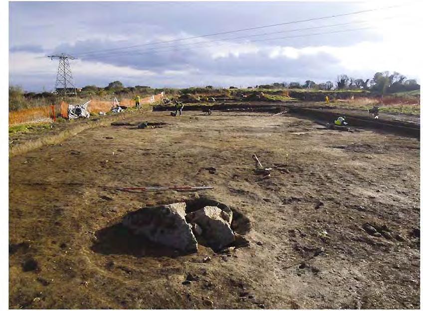

208

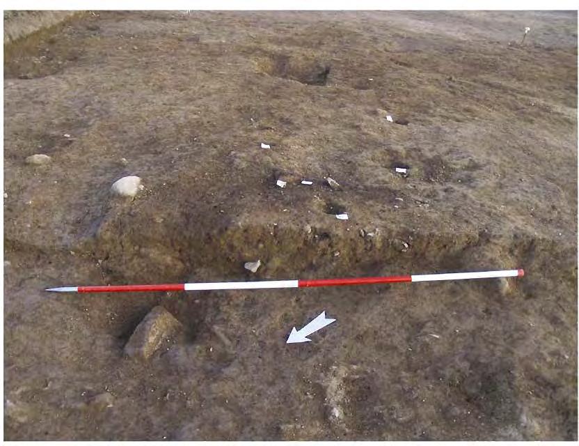
209
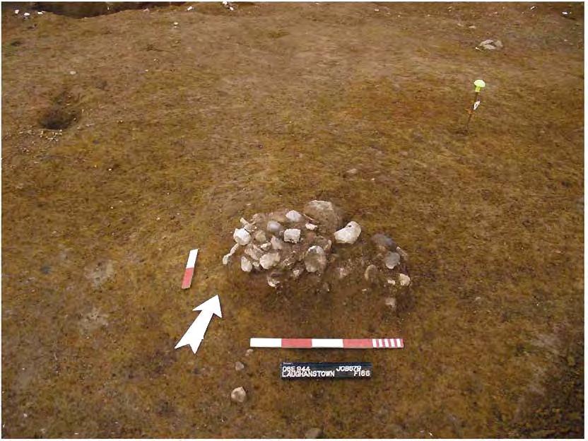
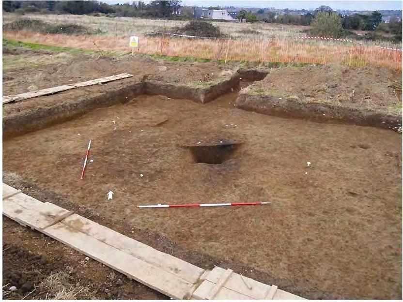
210
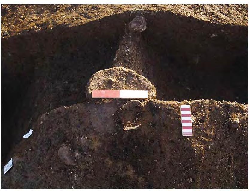
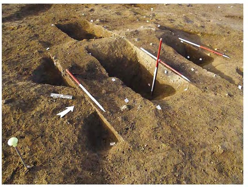
211
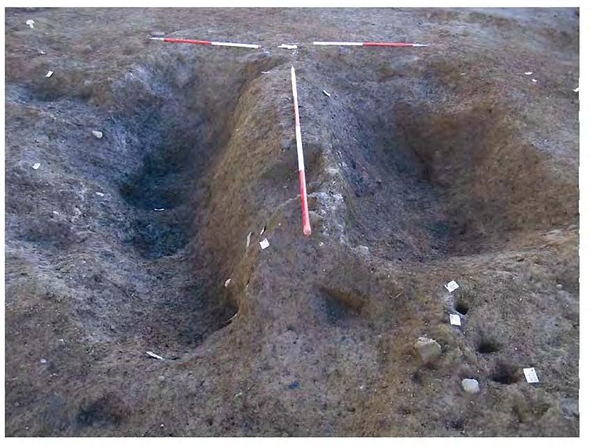
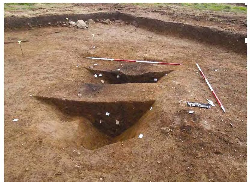
212
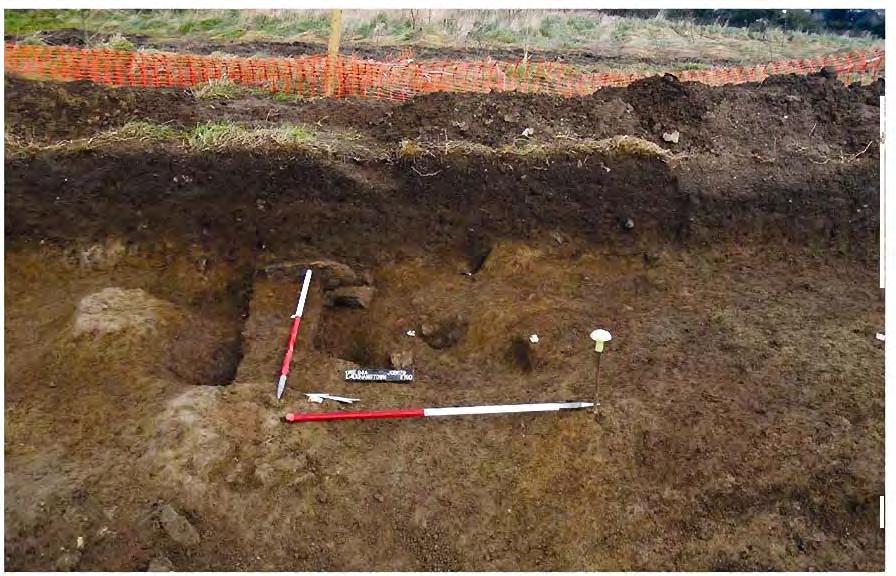
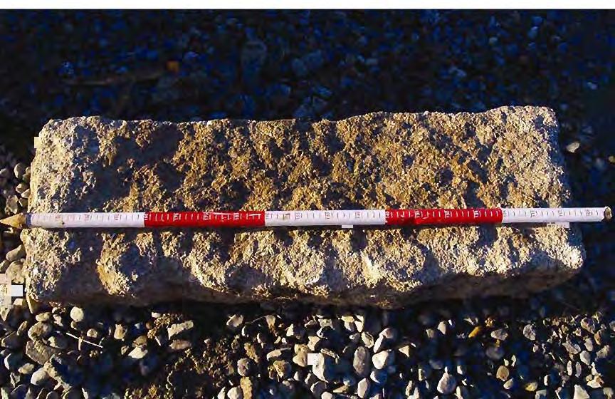
213
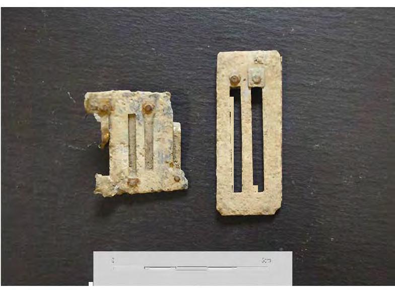
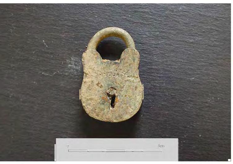
214
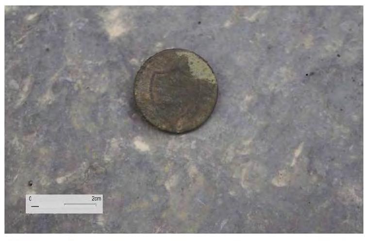
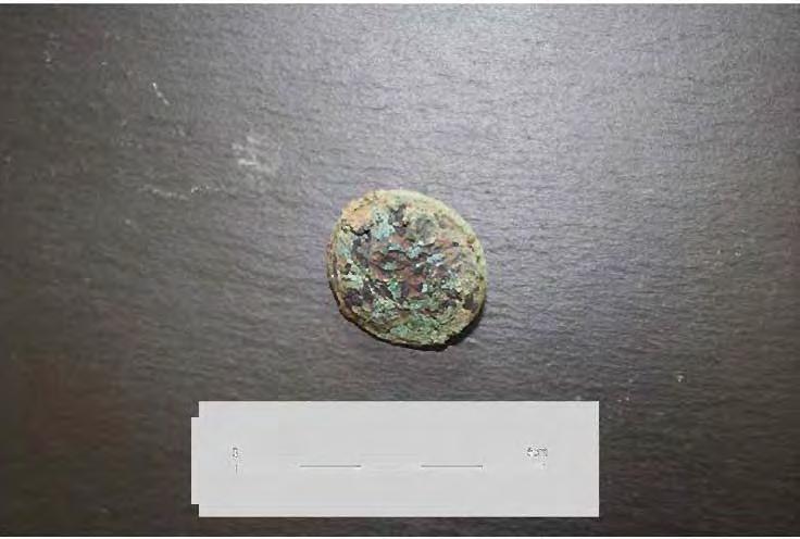
215
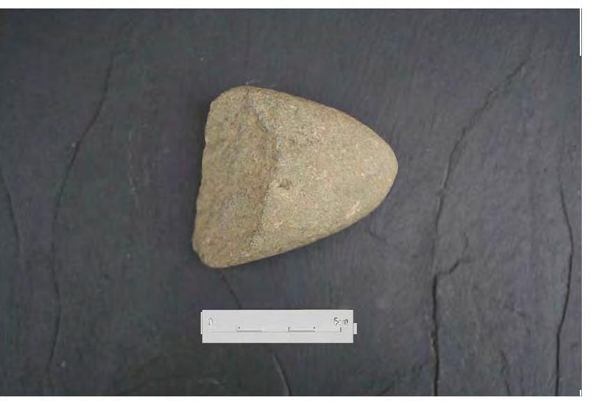
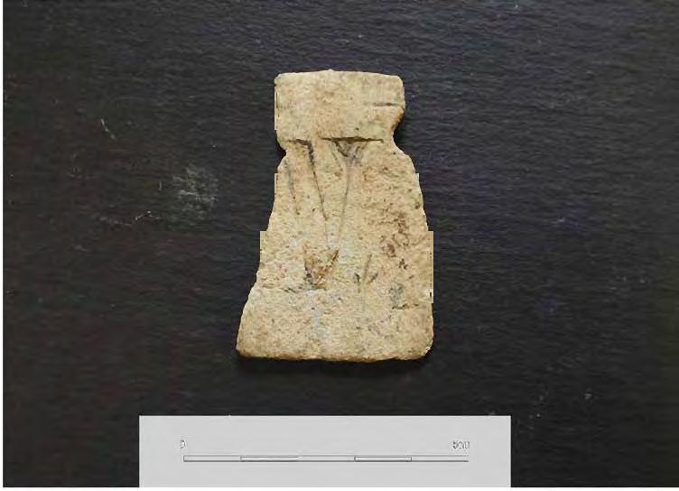
216
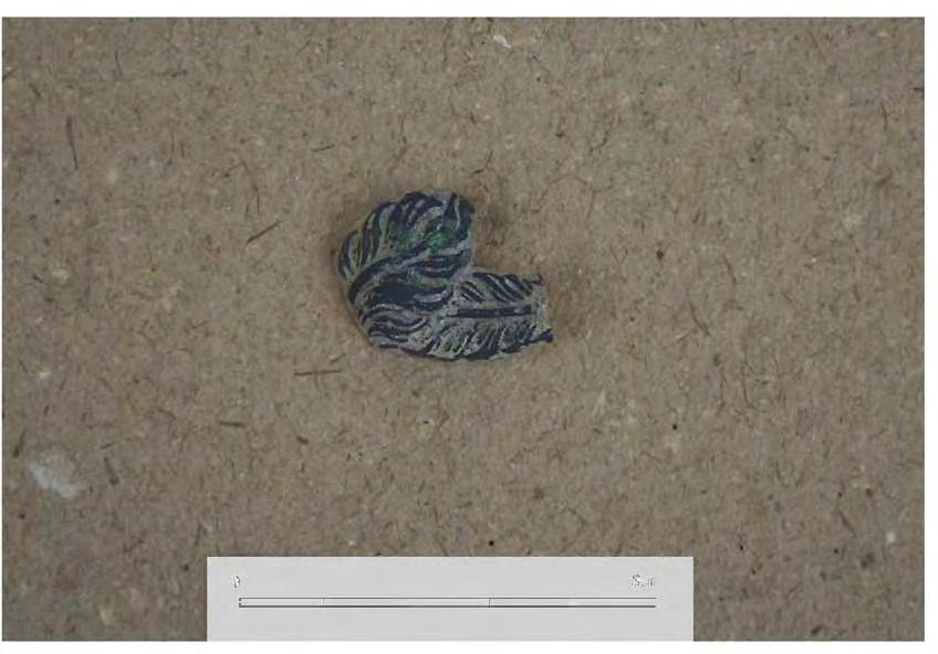
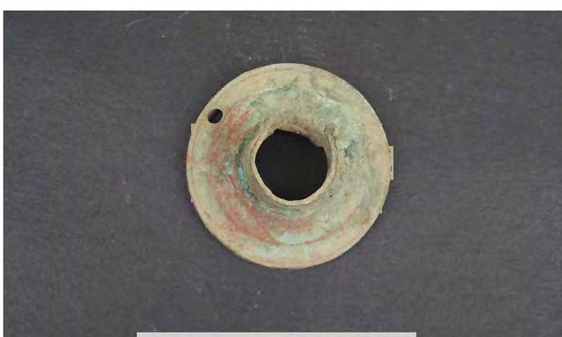
217
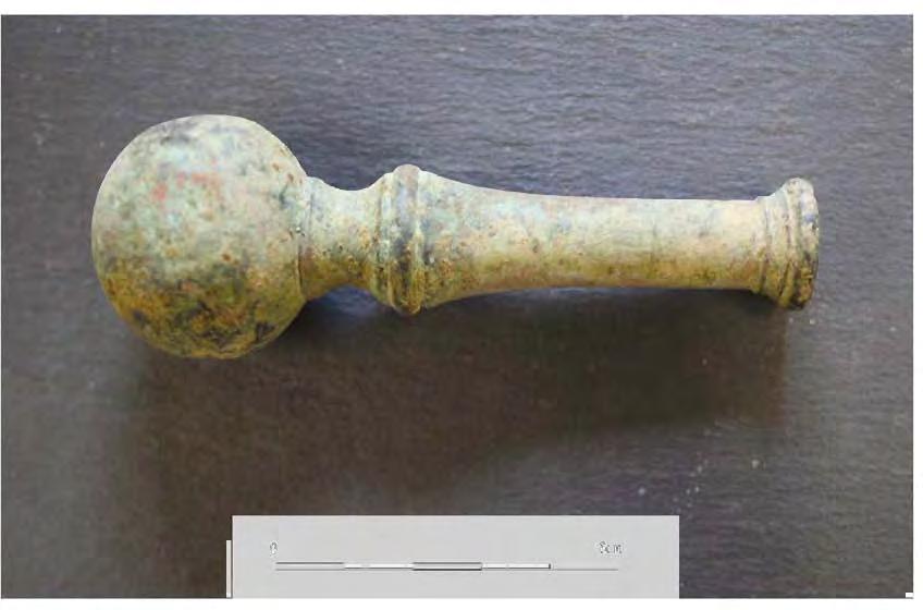
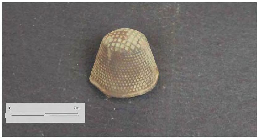
218

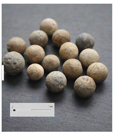
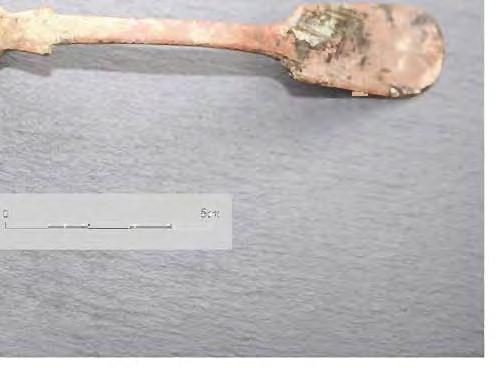
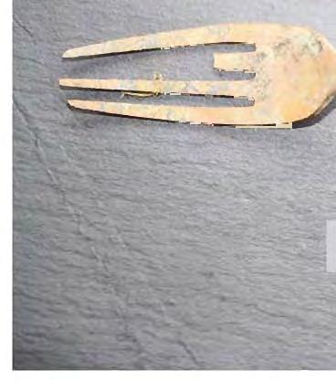
219
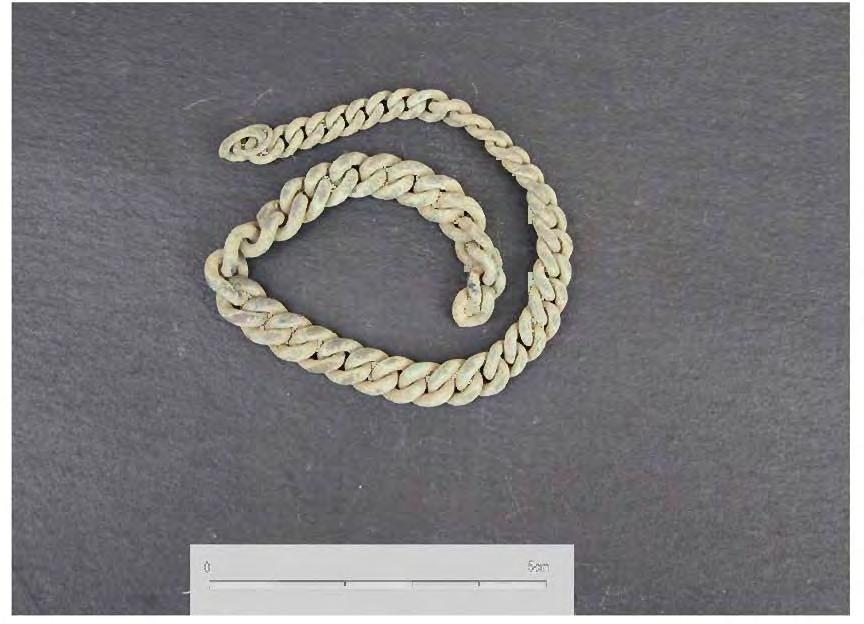
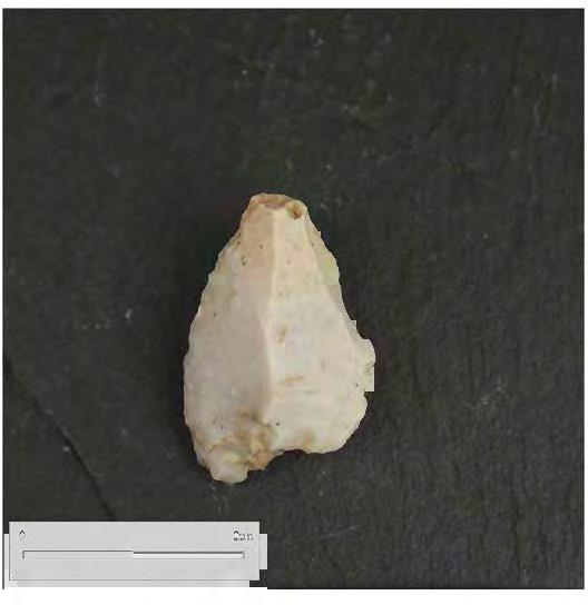
220
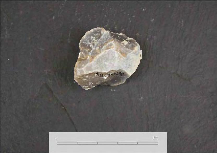
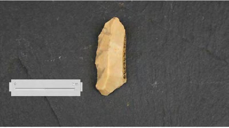
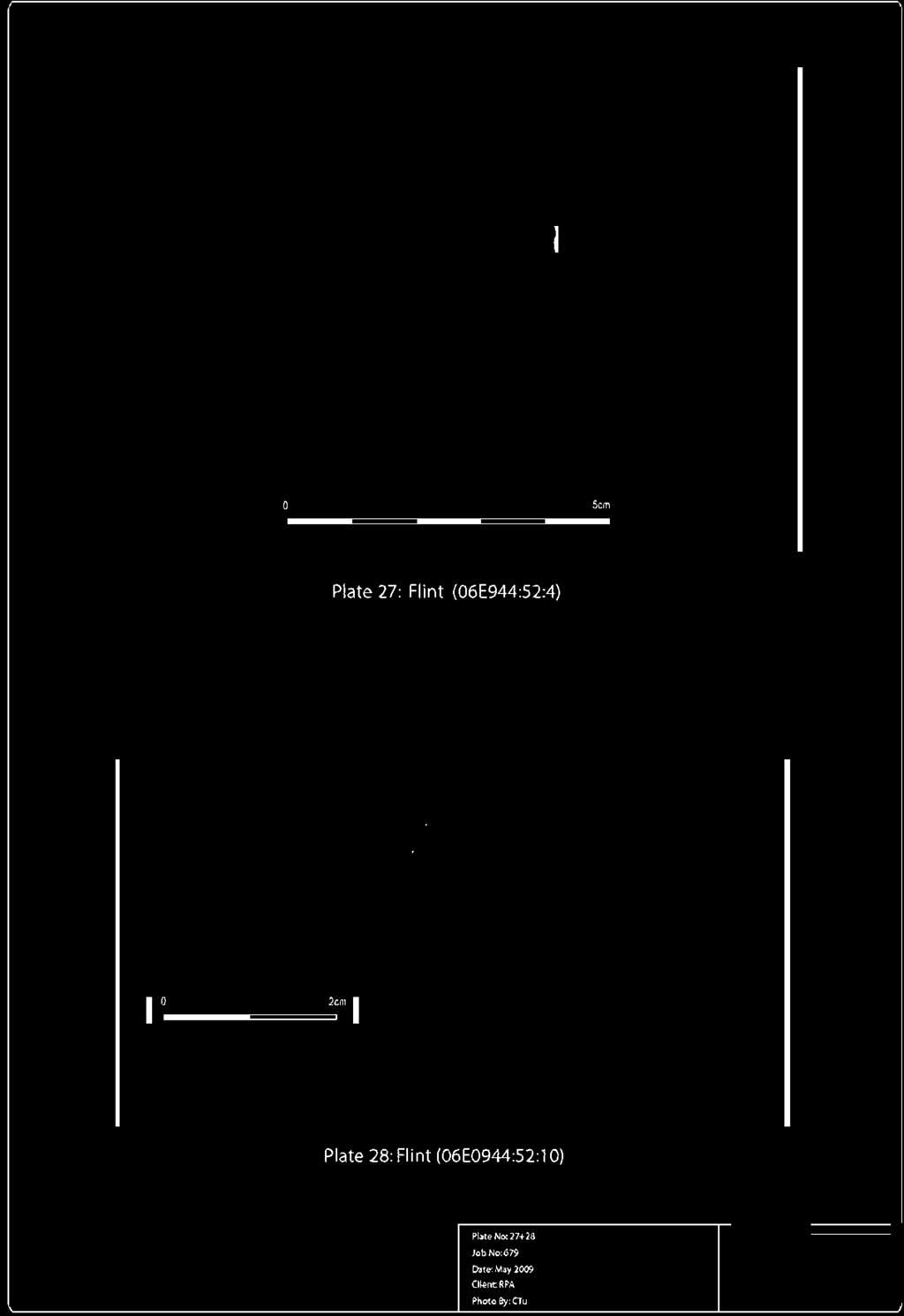
221

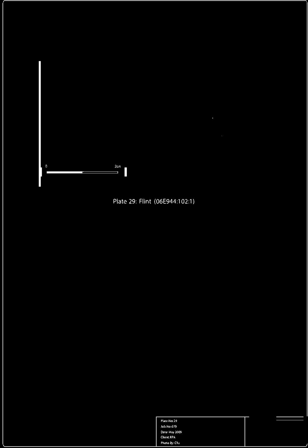
222


223
LUAS B1 Sandyford to Cherrywood Extension 06E214. Site 3A and 3B. Aaron Johnston
 LUAS B1 Sandyford to Cherrywood Extension Archaeological Test Excavation Brenanstown 06E214 Site 3A and 3B Aaron Johnston Cultural Resource Development Services Ltd. August 2006 Table of contents Table
3. The new face of Bronze Age pottery Jacinta Kiely and Bruce Sutton
 3. The new face of Bronze Age pottery Jacinta Kiely and Bruce Sutton Illus. 1 Location map of Early Bronze Age site at Mitchelstown, Co. Cork (based on the Ordnance Survey Ireland map) A previously unknown
ARCHAEOLOGICAL EVALUATION AT BRIGHTON POLYTECHNIC, NORTH FIELD SITE, VARLEY HALLS, COLDEAN LANE, BRIGHTON. by Ian Greig MA AIFA.
 ARCHAEOLOGICAL EVALUATION AT BRIGHTON POLYTECHNIC, NORTH FIELD SITE, VARLEY HALLS, COLDEAN LANE, BRIGHTON by Ian Greig MA AIFA May 1992 South Eastern Archaeological Services Field Archaeology Unit White
7. Prehistoric features and an early medieval enclosure at Coonagh West, Co. Limerick Kate Taylor
 7. Prehistoric features and an early medieval enclosure at Coonagh West, Co. Limerick Kate Taylor Illus. 1 Location of the site in Coonagh West, Co. Limerick (based on the Ordnance Survey Ireland map)
Colchester Archaeological Trust Ltd. A Fieldwalking Survey at Birch, Colchester for ARC Southern Ltd
 Colchester Archaeological Trust Ltd A Fieldwalking Survey at Birch, Colchester for ARC Southern Ltd November 1997 CONTENTS page Summary... 1 Background... 1 Methods... 1 Retrieval Policy... 2 Conditions...
New Composting Centre, Ashgrove Farm, Ardley, Oxfordshire
 New Composting Centre, Ashgrove Farm, Ardley, Oxfordshire An Archaeological Watching Brief For Agrivert Limited by Andrew Weale Thames Valley Archaeological Services Ltd Site Code AFA 09/20 August 2009
An archaeological watching brief and recording at Brightlingsea Quarry, Moverons Lane, Brightlingsea, Essex October 2003
 An archaeological watching brief and recording at Brightlingsea Quarry, Moverons Lane, Brightlingsea, Essex commissioned by Mineral Services Ltd on behalf of Alresford Sand & Ballast Co Ltd report prepared
A Sense of Place Tor Enclosures
 A Sense of Place Tor Enclosures Tor enclosures were built around six thousand years ago (4000 BC) in the early part of the Neolithic period. They are large enclosures defined by stony banks sited on hilltops
Cambridge Archaeology Field Group. Fieldwalking on the Childerley Estate Cambridgeshire
 Cambridge Archaeology Field Group Fieldwalking on the Childerley Estate Cambridgeshire 2009 to 2014 Summary Fieldwalking on the Childerley estate of Martin Jenkins and Family has revealed, up to March
Church of St Peter and St Paul, Great Missenden, Buckinghamshire
 Church of St Peter and St Paul, Great Missenden, Buckinghamshire An Archaeological Watching Brief for the Parish of Great Missenden by Andrew Taylor Thames Valley Archaeological Services Ltd Site Code
Archaeological. Monitoring & Recording Report. Fulbourn Primary School, Cambridgeshire. Archaeological Monitoring & Recording Report.
 Fulbourn Primary School, Cambridgeshire Archaeological Monitoring & Recording Report October 2014 Client: Cambridgeshire County Council OA East Report No: 1689 OASIS No: oxfordar3-192890 NGR: TL 5190 5613
Lanton Lithic Assessment
 Lanton Lithic Assessment Dr Clive Waddington ARS Ltd The section headings in the following assessment report refer to those in the Management of Archaeological Projects (HBMC 1991), Appendix 4. 1. FACTUAL
Archaeological sites and find spots in the parish of Burghclere - SMR no. OS Grid Ref. Site Name Classification Period
 Archaeological sites and find spots in the parish of Burghclere - SMR no. OS Grid Ref. Site Name Classification Period SU45NE 1A SU46880 59200 Ridgemoor Farm Inhumation Burial At Ridgemoor Farm, on the
Cambridge Archaeology Field Group. Fieldwalking on the Childerley Estate, Cambridgeshire. Autumn 2014 to Spring Third interim report
 Cambridge Archaeology Field Group Fieldwalking on the Childerley Estate, Cambridgeshire Autumn 2014 to Spring 2015 Third interim report Summary Field walking on the Childerley estate of Martin Jenkins
A Fieldwalking Project At Sompting. West Sussex
 by John Funnell Introduction A Fieldwalking Project At Sompting. West Sussex During March -and April 1995 the Brighton and Hove Archaeological Society conducted fie1dwa1king in a field at Sompting West
An archaeological evaluation at the Lexden Wood Golf Club (Westhouse Farm), Lexden, Colchester, Essex
, Lexden, Colchester, Essex") An archaeological evaluation at the Lexden Wood Golf Club (Westhouse Farm), Lexden, Colchester, Essex January 2000 Archive report on behalf of Lexden Wood Golf Club Colchester Archaeological Trust 12 Lexden
An archaeological evaluation at the Lexden Wood Golf Club (Westhouse Farm), Lexden, Colchester, Essex January 2000 Archive report on behalf of Lexden Wood Golf Club Colchester Archaeological Trust 12 Lexden
An archaeological evaluation at 16 Seaview Road, Brightlingsea, Essex February 2004
 An archaeological evaluation at 16 Seaview Road, Brightlingsea, Essex February 2004 report prepared by Kate Orr on behalf of Highfield Homes NGR: TM 086 174 (c) CAT project ref.: 04/2b ECC HAMP group site
The lithic assemblage from Kingsdale Head (KH09)
") 1 The lithic assemblage from Kingsdale Head (KH09) Hannah Russ Introduction During excavation the of potential Mesolithic features at Kingsdale Head in 2009 an assemblage of flint and chert artefacts were
1 The lithic assemblage from Kingsdale Head (KH09) Hannah Russ Introduction During excavation the of potential Mesolithic features at Kingsdale Head in 2009 an assemblage of flint and chert artefacts were
BALNUARAN. of C LAVA. a prehistoric cemetery. A Visitors Guide to
 A Visitors Guide to BALNUARAN of C LAVA a prehistoric cemetery Milton of Clava Chapel (?) Cairn River Nairn Balnuaran of Clava is the site of an exceptionally wellpreserved group of prehistoric burial
Greater London GREATER LONDON 3/606 (E ) TQ
 TQ") GREATER LONDON City of London 3/606 (E.01.6024) TQ 30358150 1 PLOUGH PLACE, CITY OF LONDON An Archaeological Watching Brief at 1 Plough Place, City of London, London EC4 Butler, J London : Pre-Construct
GREATER LONDON City of London 3/606 (E.01.6024) TQ 30358150 1 PLOUGH PLACE, CITY OF LONDON An Archaeological Watching Brief at 1 Plough Place, City of London, London EC4 Butler, J London : Pre-Construct
Test-Pit 3: 31 Park Street (SK )
") -Pit 3: 31 Park Street (SK 40732 03178) -Pit 3 was excavated in a flower bed in the rear garden of 31 Park Street, on the northern side of the street and west of an alleyway leading to St Peter s Church,
-Pit 3: 31 Park Street (SK 40732 03178) -Pit 3 was excavated in a flower bed in the rear garden of 31 Park Street, on the northern side of the street and west of an alleyway leading to St Peter s Church,
Former Whitbread Training Centre Site, Abbey Street, Faversham, Kent Interim Archaeological Report Phase 1 November 2009
 Former Whitbread Training Centre Site, Abbey Street, Faversham, Kent Interim Archaeological Report Phase 1 November 2009 SWAT. Archaeology Swale and Thames Archaeological Survey Company School Farm Oast,
THE UNFOLDING ARCHAEOLOGY OF CHELTENHAM
 THE UNFOLDING ARCHAEOLOGY OF CHELTENHAM The archaeology collection of Cheltenham Art Gallery & Museum contains a rich quantity of material relating to the prehistoric and Roman occupation of the North
Erection of wind turbine, Mains of Loanhead, Old Rayne, AB52 6SX
 Erection of wind turbine, Mains of Loanhead, Old Rayne, AB52 6SX Ltd 23 November 2011 Erection of wind turbine, Mains of Loanhead, Old Rayne, AB52 6SX CONTENTS 1 INTRODUCTION 3 2 ARCHAEOLOGICAL BACKGROUND
2 Saxon Way, Old Windsor, Berkshire
 2 Saxon Way, Old Windsor, Berkshire An Archaeological Watching Brief For Mrs J. McGillicuddy by Pamela Jenkins Thames Valley Archaeological Services Ltd Site Code SWO 05/67 August 2005 Summary Site name:
Archaeological Material From Spa Ghyll Farm, Aldfield
 Archaeological Material From Spa Ghyll Farm, Aldfield Introduction Following discussions with Linda Smith the Rural Archaeologist for North Yorkshire County Council, Robert Morgan of 3D Archaeological
39, Walnut Tree Lane, Sudbury (SUY 073) Planning Application No. B/04/02019/FUL Archaeological Monitoring Report No. 2005/112 OASIS ID no.
 Planning Application No. B/04/02019/FUL Archaeological Monitoring Report No. 2005/112 OASIS ID no.") 39, Walnut Tree Lane, Sudbury (SUY 073) Planning Application No. B/04/02019/FUL Archaeological Monitoring Report No. 2005/112 OASIS ID no. 9273 Summary Sudbury, 39, Walnut Tree Lane, Sudbury (TL/869412;
39, Walnut Tree Lane, Sudbury (SUY 073) Planning Application No. B/04/02019/FUL Archaeological Monitoring Report No. 2005/112 OASIS ID no. 9273 Summary Sudbury, 39, Walnut Tree Lane, Sudbury (TL/869412;
Monitoring Report No. 99
 Monitoring Report No. 99 Enniskillen Castle Co. Fermanagh AE/06/23 Cormac McSparron Site Specific Information Site Name: Townland: Enniskillen Castle Enniskillen SMR No: FER 211:039 Grid Ref: County: Excavation
Silwood Farm, Silwood Park, Cheapside Road, Ascot, Berkshire
 Silwood Farm, Silwood Park, Cheapside Road, Ascot, Berkshire An Archaeological Watching Brief For Imperial College London by Tim Dawson Thames Valley Archaeological Services Ltd Site Code SFA 09/10 April
Grim s Ditch, Starveall Farm, Wootton, Woodstock, Oxfordshire
 Grim s Ditch, Starveall Farm, Wootton, Woodstock, Oxfordshire An Archaeological Recording Action For Empire Homes by Steve Ford Thames Valley Archaeological Services Ltd Site Code SFW06/118 November 2006
2010 Watson Surface Collection
 2010 Watson Surface Collection Carol Cowherd Charles County Archaeological Society of Maryland, Inc. Chapter of Archeological Society of Maryland, Inc. November 2010 2011 Charles County Archaeological
Chapter 2. Remains. Fig.17 Map of Krang Kor site
 Chapter 2. Remains Section 1. Overview of the Survey Area The survey began in January 2010 by exploring the site of the burial rootings based on information of the rooted burials that was brought to the
Novington, Plumpton East Sussex
 Novington, Plumpton East Sussex The Flint Over 1000 pieces of flintwork were recovered during the survey, and are summarised in Table 0. The flint is of the same types as found in the previous survey of
STONES OF STENNESS HISTORIC ENVIRONMENT SCOTLAND STATEMENT OF SIGNIFICANCE
 Property in Care (PIC) ID: PIC321 Designations: Scheduled Monument (SM90285); Taken into State care: 1906 (Guardianship) Last reviewed: 2003 HISTORIC ENVIRONMENT SCOTLAND STATEMENT OF SIGNIFICANCE STONES
An archaeological evaluation in the playground of Colchester Royal Grammar School, Lexden Road, Colchester, Essex
 An archaeological evaluation in the playground of Colchester Royal Grammar School, Lexden Road, Colchester, Essex February 2002 on behalf of Roff Marsh Partnership CAT project code: 02/2c Colchester Museum
THE RAVENSTONE BEAKER
 DISCOVERY THE RAVENSTONE BEAKER K. J. FIELD The discovery of the Ravenstone Beaker (Plate Xa Fig. 1) was made by members of the Wolverton and District Archaeological Society engaged on a routine field
16 members of the Fieldwalking Group met York Community Archaeologist Jon Kenny at Lou Howard s farm, Rose Cottage Farm, at
 Terrington History Group Fieldwalking Group Field 1 Final report 21 October 2011 - fieldwalking 16 members of the Fieldwalking Group met York Community Archaeologist Jon Kenny at Lou Howard s farm, Rose
Archaeological Watching Brief (Phase 2) at Court Lodge Farm, Aldington, near Ashford, Kent December 2011
 at Court Lodge Farm, Aldington, near Ashford, Kent December 2011") Archaeological Watching Brief (Phase 2) at Court Lodge Farm, Aldington, near Ashford, Kent December 2011 SWAT. Archaeology Swale and Thames Archaeological Survey Company School Farm Oast, Graveney Road
Archaeological Watching Brief (Phase 2) at Court Lodge Farm, Aldington, near Ashford, Kent December 2011 SWAT. Archaeology Swale and Thames Archaeological Survey Company School Farm Oast, Graveney Road
Changing People Changing Landscapes: excavations at The Carrick, Midross, Loch Lomond Gavin MacGregor, University of Glasgow
 Changing People Changing Landscapes: excavations at The Carrick, Midross, Loch Lomond Gavin MacGregor, University of Glasgow Located approximately 40 kilometres to the south-west of Oban, as the crow flies
Greater London Region GREATER LONDON 3/567 (E.01.K099) TQ BERMONDSEY STREET AND GIFCO BUILDING AND CAR PARK
 TQ BERMONDSEY STREET AND GIFCO BUILDING AND CAR PARK") GREATER LONDON 3/567 (E.01.K099) TQ 33307955 156-170 BERMONDSEY STREET AND GIFCO BUILDING AND CAR PARK Assessment of an Archaeological Excavation at 156-170 Bermondsey Street and GIFCO Building and Car
GREATER LONDON 3/567 (E.01.K099) TQ 33307955 156-170 BERMONDSEY STREET AND GIFCO BUILDING AND CAR PARK Assessment of an Archaeological Excavation at 156-170 Bermondsey Street and GIFCO Building and Car
STONE implements and pottery indicative of Late Neolithic settlement are known to
 Late Neolithic Site in the Extreme Northwest of the New Territories, Hong Kong Received 29 July 1966 T. N. CHIU* AND M. K. WOO** THE SITE STONE implements and pottery indicative of Late Neolithic settlement
The Living and the Dead
 The Living and the Dead Round Barrows and cairns The transition from the late Neolithic to the early Bronze Age is traditionally associated with an influx of immigrants to the British Isles from continental
Essex Historic Environment Record/ Essex Archaeology and History
 Essex Historic Environment Record/ Essex Archaeology and History CAT Report 578 Summary sheet Address: Kingswode Hoe School, Sussex Road, Colchester, Essex Parish: Colchester NGR: TL 9835 2528 Type of
Grange Farm, Widmer End, Hughenden, Buckinghamshire
 Grange Farm, Widmer End, Hughenden, Buckinghamshire An Archaeological Evaluation for British Flora by Andy Taylor Thames Valley Archaeological Services Ltd Site Code GFH 05/63 July 2005 Summary Site name:
Moray Archaeology For All Project
 School children learning how to identify finds. (Above) A flint tool found at Clarkly Hill. Copyright: Leanne Demay Moray Archaeology For All Project ational Museums Scotland have been excavating in Moray
SALVAGE EXCAVATIONS AT OLD DOWN FARM, EAST MEON
 Proc. Hants. Field Club Archaeol. Soc. 36, 1980, 153-160. 153 SALVAGE EXCAVATIONS AT OLD DOWN FARM, EAST MEON By RICHARD WHINNEY AND GEORGE WALKER INTRODUCTION The site was discovered by chance in December
Monitoring Report No Sacred Heart Church Aghamore Boho Co. Fermanagh AE/10/116E. Brian Sloan L/2009/1262/F
 Monitoring Report No. 202 Sacred Heart Church Aghamore Boho Co. Fermanagh AE/10/116E Brian Sloan L/2009/1262/F Site Specific Information Site Address: Sacred Heart Church, Aghamore, Boho, Co. Fermanagh
Fort Arbeia and the Roman Empire in Britain 2012 FIELD REPORT
 Fort Arbeia and the Roman Empire in Britain 2012 FIELD REPORT Background Information Lead PI: Paul Bidwell Report completed by: Paul Bidwell Period Covered by this report: 17 June to 25 August 2012 Date
Fieldwalking at Cottam 1994 (COT94F)
") Fieldwalking at Cottam 1994 (COT94F) Tony Austin & Elizabeth Jelley (19 Jan 29) 1. Introduction During the winter of 1994 students from the Department of Archaeology at the University of York undertook
Fieldwalking at Cottam 1994 (COT94F) Tony Austin & Elizabeth Jelley (19 Jan 29) 1. Introduction During the winter of 1994 students from the Department of Archaeology at the University of York undertook
Archaeological trial-trenching evaluation at Chappel Farm, Little Totham, Essex. April 2013
 Archaeological trial-trenching evaluation at Chappel Farm, Little Totham, Essex April 2013 report prepared by Ben Holloway commissioned by Tim Harbord Associates on behalf of Mr Tom Howie Planning reference:
An archaeological watching brief at Sheepen, Colchester, Essex November-December 2003
 An archaeological watching brief at Sheepen, Colchester, Essex November-December 2003 report prepared by Ben Holloway on behalf of Colchester Borough Council CAT project ref.: 03/11c Colchester Museums
Control ID: Years of experience: Tools used to excavate the grave: Did the participant sieve the fill: Weather conditions: Time taken: Observations:
 Control ID: Control 001 Years of experience: No archaeological experience Tools used to excavate the grave: Trowel, hand shovel and shovel Did the participant sieve the fill: Yes Weather conditions: Flurries
TIPPERARY HISTORICAL JOURNAL 1994
 TPPERARY HSTORCAL JOURNAL 1994 County Tipperary Historical Society www.tipperarylibraries.ie/ths society@tipperarylibraries. ie SSN 0791-0655 Excavations at Cormac's Chapel, Cashel, 1992 and 1993: a preliminary
Fieldwalk On Falmer Hill, Near Brighton - Second Season
 Fieldwalk On Falmer Hill, Near Brighton - Second Season by the Brighton and Hove Archaeological Society This report as well as describing the recent fieldwalks also includes descriptions of previous discoveries
Chapter 2: Archaeological Description
 Chapter 2: Archaeological Description Phase 1 Late Neolithic, c 3000-2400 BC (Figs 6-9) Evidence of Neolithic activity was confined to pits dug across the southern half of the site (Fig. 6). Eighteen pits
Education Pack for Junior Certificate History
 Education Pack for Junior Certificate History Introduction This education pack has been designed by the Brú na Bóinne guides as an aid for teachers and pupils of the Junior Certificate History syllabus.
Bronze Age 2, BC
 Bronze Age 2,000-600 BC There may be continuity with the Neolithic period in the Early Bronze Age, with the harbour being used for seasonal grazing, and perhaps butchering and hide preparation. In the
Cetamura Results
 Cetamura 2000 2006 Results A major project during the years 2000-2006 was the excavation to bedrock of two large and deep units located on an escarpment between Zone I and Zone II (fig. 1 and fig. 2);
NGSBA Excavation Reports
 ISSN 2221-9420 NGSBA Excavation Reports Volume 1 (2009) Salvage Excavation at Nahal Saif 2004 Final Report Excavation Permit: B - 293/2004 Excavating Archaeologist: Yehuda Govrin Y. G. Contract Archaeology
Evidence for the use of bronze mining tools in the Bronze Age copper mines on the Great Orme, Llandudno
 Evidence for the use of bronze mining tools in the Bronze Age copper mines on the Great Orme, Llandudno Background The possible use of bronze mining tools has been widely debated since the discovery of
An archaeological watching brief on one section of an Anglian Water main Spring Lane, Lexden, Colchester
 An archaeological watching brief on one section of an Anglian Water main Spring Lane, Lexden, Colchester April-September 2001 on behalf of Breheny Contractors CAT project ref.: 01/4D Colchester Museum
An archaeological evaluation by trial-trenching at Playgolf, Bakers Lane, Westhouse Farm, Colchester, Essex
 An archaeological evaluation by trial-trenching at Playgolf, Bakers Lane, Westhouse Farm, Colchester, Essex commissioned by Mr Stephen Belchem on behalf of ADP Ltd. report prepared by Chris Lister Planning
A visit to the Wor Barrow 21 st November 2015
 A visit to the Wor Barrow 21 st November 2015 Following our exploration of Winkelbury a few weeks previously, we fast forwarded 12 years in Pitt Rivers remarkable series of excavations and followed him
Please see our website for up to date contact information, and further advice.
 On 1st April 2015 the Historic Buildings and Monuments Commission for England changed its common name from to Historic England. We are now re-branding all our documents. Although this document refers to,
ARCHAEOLOGICAL S E R V I C E S. St Nicholas' Church, Barrack Hill, Nether Winchendon, Buckinghamshire. Archaeological Watching Brief.
 T H A M E S V A L L E Y ARCHAEOLOGICAL S E R V I C E S St Nicholas' Church, Barrack Hill, Nether Winchendon, Buckinghamshire Archaeological Watching Brief by Steven Crabb Site Code: STW17/229 (SP 7735
5. Excavation of a ringfort at Leggetsrath West, County Kilkenny Anne-Marie Lennon
 5. Excavation of a ringfort at Leggetsrath West, County Kilkenny Anne-Marie Lennon Illus. 1 Location of the Leggetsrath West ringfort, Co. Kilkenny (based on Ordnance Survey Ireland map) The ringfort at
S E R V I C E S. St John the Baptist Church, Penshurst, Kent. Archaeological Watching Brief. by Daniel Bray and James McNicoll-Norbury
 T H A M E S V A L L E Y ARCHAEOLOGICAL S E R V I C E S St John the Baptist Church, Penshurst, Kent Archaeological Watching Brief by Daniel Bray and James McNicoll-Norbury Site Code: JPK11/25 (TQ 5273 4385)
Leeming to Barton Improvement
 Start of works exhibition March 2014 Welcome Introduction Following the public inquiry in November 2006, the Secretaries of State for Transport and Communities and Local Government announced the decision
An archaeological evaluation at the Blackwater Hotel, Church Road, West Mersea, Colchester, Essex March 2003
 An archaeological evaluation at the Blackwater Hotel, Church Road, West Mersea, Colchester, Essex report prepared by Laura Pooley on behalf of Dolphin Developments (U.K) Ltd NGR: TM 0082 1259 CAT project
Is this the Original Anglo-Saxon period site of Weathercote?
 Is this the Original Anglo-Saxon period site of Weathercote? A Batty & N Crack 2016 Front Cover. Looking south east across proposed original site of Weathercote. Photograph A 2 3 Weathercote Anglo-Saxon
2.Valley bottom and hilltop: 6,000 years of settlement along the route of the N4 Sligo Inner Relief Road Michael MacDonagh
 2.Valley bottom and hilltop: 6,000 years of settlement along the route of the N4 Sligo Inner Relief Road Michael MacDonagh Illus. 1 Aerial view of archaeological test-trenches along the route of the N4
Barnet Battlefield Survey
 In terim report on the progress of the Barnet Battlefield Survey December 2016 The Barnet Battlefield Survey is an archaeological investigation into the 1471 Battle of Barnet. It aims to define more accurately
KNAP OF HOWAR HISTORIC ENVIRONMENT SCOTLAND STATEMENT OF SIGNIFICANCE. Property in Care (PIC) ID: PIC301 Designations:
 ID: PIC301 Designations:") Property in Care (PIC) ID: PIC301 Designations: Scheduled Monument (SM90195) Taken into State care: 1954 (Guardianship) Last reviewed: 2004 HISTORIC ENVIRONMENT SCOTLAND STATEMENT OF SIGNIFICANCE KNAP
Property in Care (PIC) ID: PIC301 Designations: Scheduled Monument (SM90195) Taken into State care: 1954 (Guardianship) Last reviewed: 2004 HISTORIC ENVIRONMENT SCOTLAND STATEMENT OF SIGNIFICANCE KNAP
Tell Shiyukh Tahtani (North Syria)
") Tell Shiyukh Tahtani (North Syria) Report of the 2010 excavation season conducted by the University of Palermo Euphrates Expedition by Gioacchino Falsone and Paola Sconzo In the summer 2010 the University
Tell Shiyukh Tahtani (North Syria) Report of the 2010 excavation season conducted by the University of Palermo Euphrates Expedition by Gioacchino Falsone and Paola Sconzo In the summer 2010 the University
FURTHER MIDDLE SAXON EVIDENCE AT COOK STREET, SOUTHAMPTON (SOU 567)
") Roc. Hampshire Field Club Archaeol. Soc 52,1997, 77-87 (Hampshire Studies 1997) FURTHER MIDDLE SAXON EVIDENCE AT COOK STREET, SOUTHAMPTON (SOU 567) By M F GARNER andj VINCENT with a contribution byjacqueline
Roc. Hampshire Field Club Archaeol. Soc 52,1997, 77-87 (Hampshire Studies 1997) FURTHER MIDDLE SAXON EVIDENCE AT COOK STREET, SOUTHAMPTON (SOU 567) By M F GARNER andj VINCENT with a contribution byjacqueline
ARCHAEOLOGICAL MONITORING REPORT
 ARCHAEOLOGICAL MONITORING REPORT SCCAS REPORT No. 2009/324 Thorington Hall, Stoke by Nayland SBN 087 HER Information Date of Fieldwork: November 2009 - January 2010 Grid Reference: TM 0131 3546 Funding
Peace Hall, Sydney Town Hall Results of Archaeological Program (Interim Report)
") Results of Archaeological Program (Interim Report) Background The proposed excavation of a services basement in the western half of the Peace Hall led to the archaeological investigation of the space in
Results of Archaeological Program (Interim Report) Background The proposed excavation of a services basement in the western half of the Peace Hall led to the archaeological investigation of the space in
Advanced archaeology at the archive. Museum of London Support materials AS/A2 study day
 Advanced archaeology at the archive Support materials AS/A2 study day Contents National Curriculum links and session description 1-2 Example timetable 3 Practical guidelines 4 Visit preparation and pre-visit
St Germains, Tranent, East Lothian: the excavation of Early Bronze Age remains and Iron Age enclosed and unenclosed settlements
 Proc Soc Antiq Scot, 128 (1998), 203-254 St Germains, Tranent, East Lothian: the excavation of Early Bronze Age remains and Iron Age enclosed and unenclosed settlements Derek Alexander* & Trevor Watkinsf
SCOTLAND. Belfast IRISH SEA. Dublin THE REPUBLIC OF IRELAND ENGLAND ENGLISH CHANNEL. Before and After
 ALL ABOUT BRITAIN This book tells the story of the people who have lived in the British Isles, and is packed with fascinating facts and f un tales. The British Isles is a group of islands that consists
CUMBRIA 2/635 (C ) NY
 NY") CUMBRIA Allerdale 2/635 (C.16.6017) NY 11803070 BRIDGE STREET, COCKERMOUTH Report on an Archaeological Evaluation at Bridge Street, Cockermouth, Cumbria (Report No. 5/00) Grahame, R Carlisle : Carlisle
CUMBRIA Allerdale 2/635 (C.16.6017) NY 11803070 BRIDGE STREET, COCKERMOUTH Report on an Archaeological Evaluation at Bridge Street, Cockermouth, Cumbria (Report No. 5/00) Grahame, R Carlisle : Carlisle
Undley Hall, Lakenheath LKH 307
 ARCHAEOLOGICAL EVALUATION AND MONITORING REPORT SCCAS REPORT No. 2010/005 Undley Hall, Lakenheath LKH 307 E. Muldowney SCCAS January 2010 www.suffolkcc.gov.uk/e-and-t/archaeology Lucy Robinson, County
Hembury Hillfort Lesson Resources. For Key Stage Two
 Hembury Hillfort Lesson Resources For Key Stage Two 1 Resource 1 Email 1 ARCHAEOLOGISTS NEEDED Dear Class, I recently moved to Payhembury and I have been having fun exploring the beautiful Blackdown Hills.
Burrell Orchard 2014: Cleveland Archaeological Society Internship Amanda Ponomarenko The Ohio State University June - August 2014
 1 Burrell Orchard 2014: Cleveland Archaeological Society Internship Amanda Ponomarenko The Ohio State University June - August 2014 Selected for the 2014 Cleveland Archaeological Society Internship in
Centre for Archaeological Fieldwork School of Geography, Archaeology and Palaeoecology Queen s University Belfast
 Centre for Archaeological Fieldwork School of Geography, Archaeology and Palaeoecology Queen s University Belfast Data Structure Report No. 73 (preliminary report) On behalf of # Queen s University Belfast
Phase 2 Urban consolidation AD
 Phase 2 Urban consolidation AD 1250-1350 The second recognised phase of activity at Rådhuspladsen corresponded approximately to the High medieval period (c. AD 1250 1350), and saw consolidation of the
Bristol & Gloucestershire Archaeological Society
 Chris Hayden, Rob Early, Edward Biddulph, Paul Booth, Anne Dodd, Alex Smith, Granville Laws and Ken Welsh, Horcott Quarry, Fairford and Arkell's Land, Kempsford: Prehistoric, Roman and Anglo-Saxon settlement
ST PATRICK S CHAPEL, ST DAVIDS PEMBROKESHIRE 2015
 ST PATRICK S CHAPEL, ST DAVIDS PEMBROKESHIRE 2015 REPORT FOR THE NINEVEH CHARITABLE TRUST THE UNIVERSITY OF SHEFFIELD AND DYFED ARCHAEOLOGICAL TRUST Introduction ST PATRICK S CHAPEL, ST DAVIDS, PEMBROKESHIRE,
Excavations at Shikarpur, Gujarat
 Excavations at Shikarpur, Gujarat 2008-2009 The Department of Archaeology and Ancient History, the M. S. University of Baroda continued excavations at Shikarpur in the second field season in 2008-09. In
The excavation of a coastal promontory fort at Porth y Rhaw, Solva, Pembrokeshire,
 Archaeologia Cambrensis 159 (2010), 53 98 The excavation of a coastal promontory fort at Porth y Rhaw, Solva, Pembrokeshire, 1995 98 By PETE CRANE and KENNETH MURPHY 1 with contributions by A. E. Caseldine
December 6, Paul Racher (P007) Archaeological Research Associates Ltd. 900 Guelph St. Kitchener ON N2H 5Z6
 Archaeological Research Associates Ltd. 900 Guelph St. Kitchener ON N2H 5Z6") Ministry of Tourism, Culture and Sport Culture Programs Unit Programs and Services Branch Culture Division 401 Bay Street, Suite 1700 Toronto ON M7A 0A7 Tel.: 416-314-2120 Ministère du Tourisme, de la
Ministry of Tourism, Culture and Sport Culture Programs Unit Programs and Services Branch Culture Division 401 Bay Street, Suite 1700 Toronto ON M7A 0A7 Tel.: 416-314-2120 Ministère du Tourisme, de la
3.4 The prehistoric lithic assemblage by I.P. Brooks. Introduction. Raw materials. Distribution
 3.4 The prehistoric lithic assemblage by I.P. Brooks Introduction A total of 1656 flint and chert artefacts were recovered during the excavations at Fullerton. The majority of these were found in two trenches,
Section Worked stone catalogue By Hugo Anderson-Whymark
 Section 4.11.2 Worked stone catalogue By Hugo Anderson-Whymark Table 4.67: Worked stone from Alfred s Castle. TR Ctxt SF No 1 1000 0 Weaponry Sling-shot Flint pebble 100 1 57 43 37 27 Iron Age 1 1160 0
An archaeological watching brief at St Leonard s church, Hythe Hill, Colchester, Essex
 An archaeological watching brief at St Leonard s church, Hythe Hill, Colchester, Essex report prepared by Adam Wightman on behalf of Dorvell Construction CAT project ref.: 10/5d Colchester and Ipswich
Archaeological evaluation at the Onley Arms, The Street, Stisted, Essex
 Archaeological evaluation at the Onley Arms, The Street, Stisted, Essex November 2014 report by Pip Parmenter and Adam Wightman with a contribution from Stephen Benfield and illustrations by Emma Holloway
EARLY HISTORIC SCOTLAND
 EARLY HISTORIC SCOTLAND This artist s reconstruction of a crannog in a loch shows the stony platform on which the timber structures were built, and a small jetty at the gate. The main house here is round,
The Neolithic Spiritual Landscape
 The For the earliest inhabitants of the island, certain places had a special significance and these were often marked in some way to highlight the spiritual nature of the place. The earliest known religious
THE EXCAVATION OF A BURNT MOUND AT HARBRIDGE, HAMPSHIRE
 Proc Hampshire Field ClubArchaeolSoc5i, 1999,172-179 (Hampshire Studies 1999) THE EXCAVATION OF A BURNT MOUND AT HARBRIDGE, HAMPSHIRE by S J SHENNAN ABSTRACT A burnt mound of Late Brome Age date, as indicated
E x cav atio n R e p o r t
 Medieval Trackway on land at Ivy Farm Royston, Hertfordshire Excavation Report E x cav atio n R e p o r t October 2011 Client: CgMs Consulting OA East Report No: 1305 OASIS No: oxfordar3-112012 NGR: TL
THE PRE-CONQUEST COFFINS FROM SWINEGATE AND 18 BACK SWINEGATE
 THE PRE-CONQUEST COFFINS FROM 12 18 SWINEGATE AND 18 BACK SWINEGATE An Insight Report By J.M. McComish York Archaeological Trust for Excavation and Research (2015) Contents 1. INTRODUCTION... 3 2. THE