The Tell Nader and Tell Baqrta Project in the Kurdistan Region of Iraq: Preliminary Report of the 2011 Season.
|
|
|
- Lionel Hudson
- 6 years ago
- Views:
Transcription

1 The Tell Nader and Tell Baqrta Project in the Kurdistan Region of Iraq: Preliminary Report of the 2011 Season. Konstantinos KOPANIAS, Claudia BEUGER, Tristan CARTER, Sherry FOX, Angelos HADJIKOUMIS, Georgia KOURTESSI-PHILIPPAKIS, Alexandra LIVARDA, John MACGINNIS Submitted for publication in SUBARTU - Archaeological Journal of the Kurdistan Region of Iraq (April 2012). Introduction...1 Tell Nader Project...2 Preparation...2 Survey...2 Principles of excavation...3 Excavation...3 Pottery...7 Archaeobotany and environmental sampling...9 Faunal Remains...10 Human Remains...14 Lithics...15 A Preliminary Report on the Tell Nader Obsidian Characterisation...16 Tell Baqrta Project...21 Tell Baqrta - first reflections on its place in history...22 Future Directions for the Tell Nader and Tell Baqrta Project...26 Cited Works...27 Appendix...31
2 Introduction Dr. Konstantinos Kopanias In October 2010 the University of Athens obtained permission by the Ministry of Municipalities and Tourism of the Kurdistan Regional Government of Iraq (KRG), the General Directorate of Antiquities of Kurdistan and the Directorate of Antiquities of Erbil to conduct excavations in two important archaeological sites: first in Tell Nader, which lies on the outskirts of the city of Erbil and then Tell Baqrta, approximately 28 km to the south of Erbil (Fig. 1). Tell Nader was discovered by Mr. Nader Babakr Muhammad, archaeologist of the General Directorate of Antiquities of Kurdistan and Tell Baqrta was brought to our attention by Dr. Narmen Ali Muhamad Amen, Professor of Archaeology at the Salahaddin University-Hawler. In November 2010 the University of Athens obtained written permission to conduct an excavation in both sites also by the Ministry of Culture of Iraq and the State Board of Antiquities and Heritage. In addition, Mr. Nawzad Hadi Mawlood, the Governor of the Erbil Province, invited a team of the University of Athens in order to examine older and new theories concerning the location of the Gaugamela battlefield. In April and early May 2011 a 14-member archaeological and a historical team from the University of Athens, under my direction, traveled to Erbil and started a systematic excavation at Tell Nader, conducted a preparatory survey at Tell Baqrta and a topographical survey in search of the Gaugamela battlefield. This has been the first Greek archaeological excavation in Mesopotamia. This archaeological and historical expedition was financed by the Greek Ministry of Culture and Tourism, by the Greek Ministry of Foreign Affairs and the University of Athens. The cost of the archaeobotanical and zooarchaeoloical research was financed by the University of Sheffield, UK. The airline Viking Hellas kindly sponsored a total of 17 airplane tickets. Also the Governorate of Erbil offered us inexpensive accommodation at the Iraqi Institute for the Conservation of Antiquities and Heritage and the company PLAISIO sponsored two laptop computers for our research. The work of the Archaeological and Historical Mission of the University of Athens was monitored by the General Directorate of Antiquities of Kurdistan (under the direction of Mr. Malaawat Abubaker Othman Zendin) and the Directorate of Antiquities of Erbil (under the direction of Mr. Haydar Hassan Hussein). 1
3 Tell Nader Project Dr. Konstantinos Kopanias Preparation Tell Nader lies at the fringes of Erbil ( , ), approximately 6,3 km E-NE of the citadel and ca. 2,8 km SE of the Majidi Mall (Fig. 2-3). The diameter of this Tell is ca. 100 m. and its height ca. 5 m. It was located first by Mr. Nader Muhammad, an archaeologist of the General Directorate of Antiquities of Kurdistan, and was named accordingly after him. Prior to its discovery a part of it was unfortunately destroyed during construction works for the three adjacent city roads. Moreover, in an attempt to build a house, a bulldozer destroyed the NE part of the Tell and also removed part of the surface layer in its northern end (Fig. 2). The unauthorized excavation was brought to a halt by the Directorate of Antiquities and this Tell was declared an archaeological site. Despite this fact, the site remained under threat because of the very intensive building activity in the area. Thus, conducting a rescue excavation was imperative. In May 2010 Mr. Nader Muhammad and Dr. Konstantinos Kopanias conducted a preparatory inspection on the site. In August 2010 a jar burial was discovered during digging of a trench for a water pipe in the west end of the site (Fig. 4). The jar could be studied only in the photographs that Mr. Nader Muhammad kindly provided us, and it still remains buried in situ. According to Dr. Claudia Beuger (ibid.) the jar is dated probably to the Middle- rather than to the Neo-Assyrian period. Part of the skeleton was recovered and stored in the Erbil Civilization Museum, where it was studied by Dr. Sherry Fox (ibid.: TN1). During the first few days of our first campaign in April 2011 we purchased in Erbil digging tools, the necessary equipment for washing, conserving and storing the finds, as well as a tent for the night guard of the excavation. The Head of the Directorate of Antiquities of Erbil, Mr. Haydar Hussein, permitted us to use one room in his Directorate for the study of pottery and animal bones. Dr. Alexandra Livarda (ibid.) was able to build a sophisticated flotation system that recycles water for the processing of soil samples. We also prepared the excavation grid of 5x5 m squares and a topographic plan of the site. Survey Time constraints during this first campaign did not allow us to conduct an intensive survey on site. But, prior to the excavation, we surveyed the area, collected characteristic surface pottery and lithics, and noted their coordinates on the topographic plan (Fig. 5). Moreover we collected all surface finds from the 24 grid squares, which have been chosen as the starting point of the 2
4 excavation. From the surface of this 20x30 m area we collected a total of pottery sherds with a total weight of 50 kg (each sherd is represented as a randomly plotted red dot on the plan) and 660 lithics, with a total weight of 8 kg (each is represented as a randomly plotted blue dot on the plan) (Fig. 6). The surface finds indicate that Tell Nader was in use from the 6 th millennium (Hassuna period) down to the late 2 nd /early 1 st mil. B.C. (Middle/Neo-Assyrian period). The main periods of site occupation, judging from the quantity of finds, seem to have been the Late Ubaid/Early Uruk 1 and the Middle-Assyrian. Principles of excavation It was decided to conduct the excavation at Tell Nader according to the following principles: all archaeological layers, including the surface layer, are excavated in a systematic way, not only the ones that were considered to be interesting, all pottery and lithic finds are collected, weighted, photographed and will be studied. Even the undateable finds will offer valuable statistical information, all architectural remains will be conserved and, if possible, preserved, palaeoenvironmental samples from every Excavation Unit will be collected and analysed, after each excavation season, all perishable architectural remains will be properly covered, in order to keep them protected from the weather elements. Excavation The main aim of the excavation at Tell Nader is to record a stratigraphy from the Late Neolithic down to the Middle/Neo Assyrian period, which will allow us to construct a secure dating system for the locally produced pottery and the lithics. Tell Nader could become a reference point for future research in northeastern Mesopotamia. The systematic study of the palaeoenvironmental material (plant and insect remains, animal and human bones etc.) will offer a valuable insight into daily life in the area during the above mentioned periods. The excavation was conducted with the assistance of 12 Kurdish workers, divided in four groups. In each group a Greek and a Kurdish archaeologist were responsible for the documentation. The Directorate of Antiquities assigned five archaeologists to our excavation (Mr. Goran Mohammed, Ms. Hazan Latif, Ms. Lavin Jabar, Ms. Rezna Abdulkadel and Mr. Swan Ahmed) and also a driver (Mr. Ramzi Hamed). All of them worked harmoniously with their Greek colleagues and contributed significantly to the successful outcome of this campaign. Moreover, a team of three students and a teaching assistant of the Department of Archaeology of the Salahaddin University- 1 Jasim 1985; Henrickson - Thuesen 1989; Bauer et al. 1998; Hammade - Yamazaki 2006; Butterlin 2009; Carter Philip
5 Hawler took part in the excavation, as arranged by the Head of the Department, Dr. Ahmed M. Mirza. Mr. Haydar Hussein and Mr. Nader Babakr Muhammed visited regularly our excavation site and offered us their valuable assistance in many instances. We opted for the open area excavation method, which meant that the excavation was done through natural stratigraphic layers on a larger scale without maintaining bulk walls. During the first season in April 2011 we began our excavation in the northern part of the Tell, where the bulldozers had removed the surface layers, and excavated an area of 15x15 m. (Fig. 7a-b) The excavation produced a total of pottery sherds (total weight 500 kg) and lithics (total weight 24 kg), mainly flint but also 68 obsidian. All finds have been collected, inventorized and stored in the Erbil Civilization Museum. The excavation revealed so far no buildings, although several well-baked bricks have been found, which indicate the existence of architectural remains in the area. The excavation has so far revealed one main stratigraphic layer. According to the preliminary examination of the pottery, the layer seems to be dated to the Late Ubaid/Early Uruk period. To this layer belong a number of simple clay constructions: 1. An artificial concentration of small stones was unearthed in the western part of the excavation area (Fig. 8). The bulldozer removed here most of the surface layer, so this find was only m. under the surface. This stone concentration covered the interior of two simple clay constructions, probably ovens. After the careful removal of this layer, two almost circular clay constructions came to light (Fig. 9). The western one (C-1) was found partially destroyed. Part of its wall was apparently broken already in the antiquity and was moved from its original position. Nevertheless, the eastern circular construction (C-2) was not damaged 2. Inside it there was an inhumation burial of an adult woman (TN 2: Sherry Fox, ibid.) (Fig. 10). Her legs were flexed, her hands positioned on her breast and belly, but, strangely, her body was in a prone position and also her head faced the ground 3. The circular construction was too small for the body, so its feet stuck out. The impression we get is that the female was placed very carelessly inside the clay construction. Her prone position was intentional, as noted by Dr. Sherry Fox. Several pieces of clay were found near her head, an indication that the soil was shoveled very carelessly on the dead body. No funerary offerings were found inside the grave, with the exception of three dog teeth (all from different animals), which were found near the head of the dead person. With the permission of the Directorate of Antiquities, the skeleton was temporarily transported to Athens for further examination in the Wiener Laboratory of the American School of Classical Studies at 2 3 Dimensions: N-S 0,90-1,10 m. and E-W 1 m., preserved width of clay walls: 0,07-0,28 m. For the burial customs of the Ubaid: Hole For Tepe Gawra in particular: Peasnall
6 Athens 4. The anthropological study, conducted by Dr. Sherry Fox (ibid), is still in progress. A small sample of the bone material was sent to the University of Arizona (USA), where Dr. Greg Hodgins is going to conduct C-14 analysis. 2. A similar clay circular construction (C-3) was unearthed further north of the first two ones (Fig. 8). Its interior remains unexcavated, so it is not yet known whether it was also used as grave or not. Such clay constructions with similar dimensions have been found, among other sites, at Tepe Gawra 5, where they were used as ovens or kilns 6, and also at Arpachiyah 7, from contemporary layers with the one at Tell Nader. It seems that all three clay circular constructions that were discovered so far at Tell Nader were also used as ovens or kilns. After their abandonment, one of them was used as an improvised grave for the adult woman (TN 2). 3. An oval shaped installation of pebbles with burnt clay in-between them was discovered in the northern part of the excavation area (Fig. 11). On top of this installation and also around it several stone tools were unearthed. Only the lower part of this construction survives. Its upper part was destroyed by the bulldozer, as indicated by the traces of its tires and also its metal plate. 4. A two-chambered sun-dried clay construction with irregular walls also belong to this layer (Fig. 12). Its upper part was probably destroyed by the bulldozer. It seems to be similar with a two-chambered pottery kiln at Yarim Tepe I Near the two-chambered kiln is also an oval-shaped earthenware tannur, with a thick layer of ashes around it. 6. A concentration of clay pieces, similar to the ones used for the circular constructions but not in situ, pottery sherds, an almost intact plate, animal bones and two animal figurines were also excavated (Fig. 13). The great bulk of finds were pottery sherds ( with a total weight of ca. 500 kg) and also lithics (2.319 with a total weight of ca. 24 kg). The finds include many cores, flakes, blades and waste, so there is evidence of all stages of the reduction sequence (G. Kourtessi-Philippakis ibid.) (Fig. 15). A sample of the obsidian finds was sent to Dr. Tristan Carter (ibid.) at the McMaster For more information: e.g. Tepe Gawra, Square 5-S, Stratum XVI: Tobler 1950, 41 pl. XLIIa. For the terminology see Yasim 1985, 53: the term kiln refers to commercial installations used for pottery making; the term oven for those which were used for domestic purposes such as making bread; and hearth for those in the form of shallow pits used for cooking and heating. Mallowan - Cruikshank Rose 1939, 14. Oates Oates 1976, 42. 5
7 University in Canada for a non-destructive analysis with an Energy-Dispersive XRF Spectrometer. The initial analysis shows that the material originates mainly from southeastern Anatolia. From all excavated units we collected three separate soil samples: one for archaeobotany and environmental sampling, one for mineralogical analysis, and one for the identification of insects. Dr. Alexandra Livarda built an elaborate flotation machine for the archaeobotany and environmental sampling (Fig. 14), probably the first one that was used for an excavation in the Kurdistan Region, and flotated a total of 104 bulk soil samples (Livarda ibid). The soil sieving allowed us to find 18 tiny beads of different materials and colors. In addition, the excavation brought to light a total of 472 animal bones, all of which were examined by Dr. Angelos Hadjikoumis. At least 137 bones could be identified (Hadjikoumis ibid.). We also found a total of five clay animal figurines, which probably served as toys and not as votives 9. The first one (U608-BAG18-V7), possibly depicting a ram (?), clearly resembles figurines from the Ubaid layer at Tepe Gawra 10 (Fig. 16). The second animal figurine (U35-BAG2-V1), possibly depicting a sheep (?), is also very similar to Ubaid finds from Tepe Gawra 11 (Fig. 17). The excavation also produced six of the so called clay nails (Tonnägel), which are very typical of the Ubaid period (Fig. 18). There has been some speculation about their interpretation (decorative wall pegs, paint grinders, sickle hand protectors, model bull's horns, nail-shaped mullers) 12, but the matter is still unresolved. These clay nails are found in southern Mesopotamia 13, but also in sites near Tell Nader, such as Arpachiyah 14 and Tepe Gawra 15. Another interesting find is a clay horn-shaped object (Fig. 19) and a similar cone object with a flattened upper end (Fig. 20). Such objects have been interpreted as tokens 16 or gaming pieces 17. Close parallels have been found in a tomb from Stratum XVIII at Tepe Gawra 18. At Tell Nader we have also unearthed clay spindle whorls (Fig. 21), similar to those known in several north Mesopotamian sites 19 and also Qalinj Agha 20, terracotta disks perforated through the middle, which served as jar stoppers (Fig. 22) 21, and also a stone macehead (U403-BAG8) Tobler 1950, Tepe Gawra: 1) Tobler 1950, 224 pl. LXXXII.c.6. 2) Tobler 1950, 224 pl. LXXXII.c.1. 3) Tobler 1950, 243 pl. LXXXI.b.2, pl. CLIV.12. The figurine cannot be compared with Ubaid figurines from southern Mesopotamia (e.g. from Uruk: Wrede 2003, pl ), but bears clear similarity with figurines from North Mesopotamian sites: e.g. Arpachiyah (Mallowan - Cruikshank Rose 1939, 88 fig. 48 no. 8) and Choga Mami (Oates 1969, 149 Pl. 31e). Tobler 1950, 243 pl. CLIV.18. Tobler 1950, 169. e.g. Uruk: Schmidt 1972, 39 pl. 59 no (I thank Dr. M. Van Esch for this parallel). Mallowan - Cruikshank Rose 1939, 90 pl Tobler 1950, 224 pl. LXXXIII f-g. For a discussion about the tokens see Bauer et al. 1998, 46 ff. Tobler 1950, 170. Tobler 1950, pl. LXXXIV.c. e.g. Arpachiyah: Mallowan - Cruikshank Rose 1939, 88 fig. 49 nos
8 Pottery Dr. Claudia Beuger Pottery sherds, which have been collected on the surface of Tell Nader by Mr. Nader Babakr Muhammed and Dr. Konstantinos Kopanias in May 2010, showed that Chalcolithic strata should be expected on the site. In addition, the brief rescue excavation, which was conducted by the Directorate of Antiquities of Erbil in August 2010 in the west end of the site, revealed a Middle/Neo Assyrian jar burial (Fig.24.5). The finds from the survey of the team of the University of Athens and also from the first excavation season in April 2011 lead to a more precise estimation of the chronological sequence in Tell Nader. The majority of the pottery finds from the site can be dated in the Chalcolithic period, and consist mainly of painted Early Northern Ubaid pottery (Fig ), as well as pottery of the Transitional (Fig ) and the Gawra horizon (Fig ). Nevertheless, isolated finds from the Hassuna (Fig ), Samarra (Fig ) and Halaf (Fig. 23.7) periods lead to the assumption that a complete stratigraphy of the Late Neolithic/Chalcolithic is expected in the site. There are also isolated pottery finds from later periods, which indicate that the site was not abandoned altogether, namely from the Uruk period (Fig ), the early third millennium (Fig. 23.1) and probably also the early second millennium. The relatively numerous finds of characteristic Middle Assyrian pottery, which have been collected during the surface survey prior to the excavation, lead to the conclusion that this site was still in use during that time (Fig ). Finally, no certain Neo Assyrian or later pottery types have been recognized yet. The first excavation season in Tell Nader produced a total of pottery sherds. During the first excavation campaign we have concentrated mainly on the classification of the pottery according to its fabric and also the vase forms. So far we were able to define a total of 43 different fabric types. The systematic statistical analysis of the pottery material is not yet concluded, but some patterns are already visible, such as the occurrence of the Organic Tempered Fabric (F8) mainly in Middle Assyrian vase shapes. A total of more than 300 sherds have already been drawn, also thanks to the assistance of Ms. Hazan Latif and Ms. Rezna Abdulkadel, both archaeologists of the Directorate of Antiquities in Erbil Al-Soof 1966; 1968 ; 1969; al-soof Es-Siwwani 1967; Hijara 1973; Gut e.g. Arpachiyah: Mallowan - Cruikshank Rose 1939, 90 fig.49 no. 22. Tepe Gawra: Speiser 1935, pl. XLII no. 4; Rothmann 2002, pl 66 no. 629 (Level XIA/B), pl. 66 no (Level XI/XA). 7
9 Fig. No. Fabric, Decoration Date Reference Reference context 23.1 buff, very fine clay with some fine lime and Hassuna Gut 1995, tab. 4 nos. 38, Nineveh several bigger lime pieces, some black and red minerals, some fine organic temper, decoration incised light brown, very fine clay with some fine Hassuna Gut 1995, tab. 4 nos. 45 Nineveh organic temper and some fine mica, decoration incised 23.3 light brown, fine clay with a lot of coarse organic temper, some bigger pieces of lime, decoration impressed Hassuna husking tray Gut 1995, tab. 5 no. 58 Nineveh 23.4 buff, very fine clay with some-plenty organic temper, plenty of very fine and some bigger pieces of lime, some fine minerals, some polish, reddish brown paint 23.5 light buff, very fine clay with plenty of minerals (mostly black and white) and lime, some fine organic temper, smooth surface with reddish brown paint 23.6 buff, fine clay with plenty of black minerals, plenty of fine lime, some fine mica, surface with light slip and some polish, reddish brown paint 23.7 light brown, very fine clay with very fine lime, some fine black minerals, inside and outside very fine polish, black paint 23.8 buff, very fine clay with some fine organic temper, very hard (almost metallic ), some polish, black paint 23.9 greenish, very fine clay with some fine lime, some black and red minerals, some organic temper, black paint buff, very fine clay with some fine lime and several bigger lime pieces, some black and red minerals, some fine organic temper, dark brown-grey paint light buff, fine-very fine clay with plenty of fine and bigger lime pieces and minerals (red, black, white), some bigger organic temper buff, very fine clay with some fine lime and several bigger lime pieces, some black and red minerals, some fine organic temper, reddish brown paint light buff, fine clay with a lot of fine and bigger lime pieces, plenty of organic temper (sometimes not completely burned), reddish brown paint buff, very fine clay with some fine lime and several bigger lime pieces, some black and red minerals, some fine organic temper buff, very fine clay with some fine lime and several bigger lime pieces, some black and red minerals, some fine organic temper, decoration painted greenish-buff, fine clay with very fine lime and minerals (black, red, white), some bigger lime 8 Hasuna Gut 1995, tab. 8 no. 91, 92, 95 Samarra Gut 1995, tab. 26 no. 441, tab. 27 no. 450 Samarra Gut 1995, tab. 24 no. 427, Table 31, no. 491, tab. 33 no. 518, tab. 42 no. 621 Halaf Gut 1995, tab. 44 no. 689, tab. 47 no. 723, tab. 48 no. 736 Early Northern Ubaid (Gawra XIX-XVII) Early Northern Ubaid (Gawra XIX- XVII) Early Northern Ubaid (Gawra XIX- XVII) Late Ubaid- Gawra B (Gawra XII-IX) Late Ubaid/trans. Ubaid Gawra XIA-XI = Gawra A Gawra A Gawra A Early Middle Southern Uruk Akkermans 1988, 137 fig Akkermans 1988, 138 fig Gut 1995, tab. 52 no. 788 Akkermans 1988, 138 fig Matthews 2003, fig. 3.15:15 Rothman 2002, pl. 7 nos. 320, 324 Akkermans 1988, 141 fig Rothman 2002, pl. 9 nos. 723, 750 Rothman 2002, pl. 9 no. 790 Matthews 2003, fig. 4.18:4-5 Nineveh Nineveh Nineveh Nineveh Hammam et- Turkman IVA Hammam et- Turkman IVA Nineveh Hammam et- Turkman IVA Tell Brak HS6 level 3 Gawra level XII/XIIA Hammam et- Turkman VA Gawra level XIA/B Gawra level XIA/B Tell Brak HS1 level 6
10 pieces 24.1 buff (greenish), fine clay with a lot of very fine minerals, lime and organic temper, some mica, black paint 24.2 buff, fine clay with plenty coarse organic temper and fine lime 24.3 buff, fine clay with plenty coarse organic temper and fine lime 24.4 buff, fine clay with plenty coarse organic temper and fine lime (Gawra VIII) Ninivite 5 Middle/Neo- Assyrian Middle Assyrian Middle Assyrian Gut 1995, tab. 83 no Beuger 2007, 189 fig. 99 Beuger 2007, 127 fig. 60 Beuger 2007, 127 fig. 61 Nineveh Assur Assur Assur Archaeobotany and environmental sampling Dr. Alexandra Livarda, Dr. Mike Charles, Dr. Amy Bogaard The priorities of the environmental team during the first excavation season were to devise and implement a systematic soil sampling strategy and create the installations for the processing of samples. Systematic sampling allows detection of both presence and absence patterns across space and time, and therefore, reliable identification of any activity areas. In total 104 bulk soil samples were collected from all excavated units, excluding the top soil layers. The samples were processed in a York-style flotation machine, adapted to recycle water in an attempt to minimize wastage and respect the limited water resources of the area (Fig. 14). A 1mm aperture mesh was used to retain the heavy residues while the flots were being collected in a very fine piece of cloth. Forty-seven of the heavy residues were sorted in their entirety for all categories of material during the April-May 2011 field season. Most samples had small numbers of animal bone and shells fragments and worked flint/stones. In addition, 40 of the samples contained small amounts of charcoal fragments. Also, 17 small beads of various colors (black, white, grey and green) were found in 12 samples. Processing of the flots was carried out at the University of Sheffield during the summer (2011) and their analysis is ongoing. The preliminary results indicated the sporadic presence of plant macrofossils in 47 samples, including cereals, such as bread wheat (Triticum aestivum L.) and barley (Hordeum vulgare L.), possibly pea and wild species, mainly grasses (Poaceae) and mineralised seeds of Lithospermum sp. 9
11 Faunal Remains Dr. Angelos Hadjikoumis The overall aim of zooarchaeology at Tell Nader is to study and follow the evolution of all human-animal interactions at the site. This includes many specific aims revolving around general themes such as hunting, animal husbandry, the cultural role of animals, the surrounding environment and its exploitation, cuisine and many others. Due to the small size of the assemblage, its bad preservation condition and the currently crude chronology, this first faunal report remains on a general level. The faunal assemblage was recovered through hand collection and dry sieving (1mm aperture mesh). It consisted of 472 specimens but from these, only 137 recordable elements could be identified to species or genus. The assemblage was washed, studied and recorded at the Erbil Civilization Museum in May 2011 by the author. The majority of specimens were not identifiable due to severe fragmentation (mostly in the past), erosion of bone surface and, most importantly, the cement-like crust in which they were enveloped. Even among identified bones erosion and concretions were very common with a 77% affected by erosion or concretions or both. Halstead s 23 recording protocol was used with few additions and changes. Identification was aided only by anatomical atlantes 24 as no reference collection was available in Erbil. At least six species of mammal and one species of bird are represented in the assemblage. Before proceeding to the most abundant species, issues concerning rare or intrusive species are briefly addressed. Such species at Tell Nader include an equid (horse/donkey), a bird and a rodent. The equid is represented only by a heavily worn permanent maxillary premolar/molar and unfortunately it cannot be determined with certainty whether it belonged to the original archaeological assemblage or it was incorporated in it recently. Birds are represented by 4 specimens. Two left tibiotarsi fragments are compatible with a medium-sized member of the Accipitridae family 25 (diurnal birds of prey) though this should be confirmed or refuted through comparisons with modern reference specimens. A femur of a small/medium-sized bird was also recorded but not identified, as was another long bone fragment. Lastly, the remains of rodents include a near-complete skeleton of a rodent and a maxilla belonging to another individual. The 23 Halstead 2011: Barone 1976; Pales and Garcia 1982; Schmidt I would like to thank my colleague Lionel Gourichon for giving me his opinion on these specimens. Any mistakes remain mine. 10
12 remains belong to a species of the genus Spalax 26, probably Spalax ehrenbergi, although there still considerable confusion in mole rat taxonomy in the Middle East. Irrespective of species, members of the genus Spalax in the Middle East are the commonest burrowers in the region 27 and hence, most probably of intrusive origin in the upper strata of archaeological sites. The bulk of mammalian remains belong to cattle, sheep/goat, pig and dog (Table. 1). It has to be clarified that the possibility of the presence of jackal remains in the category dog is open simply due to the diachronic presence of the dog/wolf-sized golden jackal (Canis aureus) in the Middle East and despite the absence of any indication for it. According to the Maximum Anatomical Units (MaxAU) count, the most abundant species is sheep/goat (47%) followed closely by the pig (39%), while cattle, also taking into account their large size, are also significant with 11%. A canid (most probably dog) is also present in the assemblage in low numbers (3%). An interesting result concerning the sheep/goat category is that no sheep has been identified and goat contributed 14% to the total 47% of the category. Table 1: Main animal species in the 2011 Tell Nader assemblage. 26 I would like to thank my colleagues Katerina Papayiannis, Miriam Belmaker and Paul Halstead for their opinions. Any mistakes remain mine. 27 E.g. Reed
13 Data on the age-at-death are scarce and should thus be reconsidered in the future with more data. Based on tooth eruption and wear of mandibular teeth, the general tendency for sheep/goat is low mortality in the first year, high in the second and moderate from the third year onwards (Table 2). Concerning pigs, data are pointing towards high mortality in the second half of the first year and some in the second year with very few animals surviving beyond the third (Table 3). No cattle teeth were identified in the assemblage, while dog was represented by the teeth of at least two animals. One was a 1-2 month-old puppy represented by an unworn mandibular dp4. The other was an unworn upper M1, representing also a young animal, most probably younger than 6 months old. Both these teeth, along with a permanent lower incisor, were found near the head of a human burial but without any reliable evidence of association with it. This should be clarified in following seasons when more burials are excavated. Table 2: Sheep/Goat age-at death based on mandibular eruption and wear data. 12
14 Table 3: Pig age-at death based on mandibular eruption and wear data. Analyses are still under way and more results and discussion will appear in the literature soon, especially when more material comes to light for zooarchaeological study in the second excavation season scheduled for September-October
15 Human Remains Dr. Sherry C. Fox The human skeletal remains from two primary inhumation burials have been recovered, to date, from the archaeological site of Tell Nader. Recovery of the human skeletal material from TN 1 had been directed by the eponymous Mr. Nader Babakr Muhammed prior to the University of Athens excavations in April/May TN 1 is currently stored at the Erbil Civilization Museum. Temporary transfer was granted of the human and animal bone within Erbil to the Iraqi Institute for Conservation of Antiquities and Heritage where the author began examination of the human remains representing TN 1 on April 25 th. TN 1 was recovered from a broken jar with the legs in a hyperflexed position (Fig. 4). It is posited that the skeleton was bound prior to placement in the jar. The individual is largely incomplete and in a fair-to-poor state of preservation. The bones were drybrushed prior to analyses and some elements were reconstructed with UHU brand wood glue. The sex of the individual is indeterminate at present, but future study could help elucidate the sex. The age-at-death of the individual is estimated to have been 36 years + 10 years. Ten teeth have been recovered from TN 1 that require further analysis. There are non-metric traits recorded for this individual along with a possible pathology. Stature reconstruction was not attempted as no complete long bones were recovered from TN 1. Aside from the jar, no other artifacts are associated with TN 1. It is hoped that more of TN 1 will be recovered from excavations during the coming field season. The second skeleton (TN 2) was found in situ on April 27 th within a circular burial cist grave from Unit 621 (Fig. 9-10). The virtually circularly shaped enclosure, measured approximately 110 cm x 90 cm at its greatest diameter and 85 cm x 75 cm at the inside diameter with an apparent channel running along the outside circumference, near both a large ceramic sherd and on either side of two tile fragments. The cranium of TN 2 was abutting the inside circumference of the burial enclosure comprised of clay and tiles. The cranium was positioned slightly on its left side, facing down (inferiorly) toward the west, and along with the remainder of the skeleton, it appears to have been interred in a prone position with the arms and legs flexed to the left such that the right hip was likely inferior. Prone burials are not that common, from the author s experience. The femora were positioned toward the east of the cist grave. Although the human skeleton from within this circular enclosure was primarily interred, it appears to have been slightly disturbed. Once again, the preservation of the human remains is fair-to-poor. The age of this individual appears to be adult, although a more precise age-at-death remains to be estimated and the individual s sex remains to be determined. This material requires further study in a laboratory setting and the remains have been 14
16 temporarily transferred to the Wiener Laboratory of the American School of Classical Studies at Athens. At present, there are no known pathological lesions nor non-metric traits preserved. Reconstruction of adult living stature has not been attempted at this time for this individual either. There were very few grave goods associated with TN 2 in this rather simple grave. Future analyses should help provide greater information about this individual. Lithics Dr. Georgia Kourtesi-Philippaki The first excavation season in Tell Nader produced lithics with a total weight of 32.2 kg. The raw materials mainly used for the production of the lithic tools were flint (94%, i.e. ca finds in total) and obsidian (2.28%, i.e. 68 finds) (Fig. 15). An untrimmed stone and also a flake were produced in quartz. Several varieties of flint of many different colors were used. From the technological point of view there is evidence of all stages of the reduction sequence (chaine operatoire), since the finds include many cores, flakes, blades and waste. The flint tools are relatively few, in relation to the volume of lithic debitage. There is a tendency to use blades as blanks. We also find a certain type of borers. The examination of a sample of obsidian finds from the 2011 excavation season showed the existence of two stone types: a black opaque obsidian and also an almost entirely transparent greyish one. Both varieties were used for the production of blades, in most part with the pressure flaking method. Among the finds are also two cores, which are very suitable for the production of microblades. Micro-blades, as well as cores, make up a significant percentage of the total count of the lithic products. Some blades show traces of use, while one obsidian blade has a deniculate edge. 15
17 A Preliminary Report on the Tell Nader Obsidian Characterisation Dr. Tristan Carter, Dr. Renee Ford and Dr. Sarah Grant 28 Introduction While the Tell Nader chipped stone assemblage is dominated by local raw materials (see Kourtessi-Philippakis, ibid.), it also includes a small quantity of implements manufactured from obsidian (n=68, 2%), a volcanic glass razor sharp when freshly knapped whose nearest sources lay some 300km to the north in south-eastern Anatolia (Fig. 26). Although only a minority component, the obsidian is an important data-set, as scientific techniques developed over the past 50 years have enabled us to determine with great accuracy where these raw materials came from, thus shedding light on a community s regional and supra-regional connections (Chataigner 1998; Renfrew et al 1966). The methodological basis of these sourcing studies, is that (a) the obsidian of each volcanic source is remarkably homogenous with regard to its chemical composition (far more so than flint), (b) each of these source materials is chemically distinct, and can thus be analytically discriminated from one another (c) using the same analytical techniques one can then match the chemical fingerprint of an obsidian artefact with that of a source specimen in order to elucidate provenance (Pollard and Heron 2008: 75-97). While complications can arise in the process (see below), it remains that an obsidian characterisation study represents a powerful means of reconstructing the various socio-economic networks within which members of the Tell Nader community participated. Sampling and analysis In 2011 thirteen obsidian artefacts were selected for elemental characterisation (19% of total assemblage), the pieces chosen to represent the raw material variability in the assemblage with regard to colour, texture and opacity. All bar one of the artefact is in the form of fragmentary pressure-flaked blades / microblades, plus a single non-cortical flake (Fig. 27). While no cores were included in this analysis, two obsidian microblade nuclei are reported from the 2011 excavation (see Kourtessi-Philippakis, this report). The material is all considered to date to the Late Ubaid/Early Uruk Period, specifically the 5 th /4 th mil. B.C. (Kopanias, this report). The artefacts were analyzed whole and non-destructively at the McMaster Archaeological XRF Laboratory [MAX Lab] using a 28 McMaster Archaeological XRF Lab / Department of Anthropology, McMaster University, Chester New Hall, 524, 1280 Main Street West, Hamilton, ON L8S 4L9, Canada. 16
18 Thermo Scientific ARL Quant X energy-dispersive x-ray fluorescence spectrometer [EDXRF], each piece having first been cleaned in an ultrasonic tank with distilled water for ten minutes. The analysis recorded three major and twelve trace elements, their concentrations estimated through reference to various geo-standards of known composition purchased from the US Geological Service and Geological Survey of Japan. The analytical protocols and methods follow those devised by Shackley (2005, appendix; Poupeau et al 2010: 2711); full details will be provided in our final report. In attempting to provenance these artefacts raw materials, we compared their chemical signatures with those of source samples run by the MAX Lab under the same analytical conditions. In choosing which geological products to compare with the Tell Nader data, it makes sense to first consider the results of previous obsidian characterisation studies from nearby sites of similar dates, i.e. mid-6 th /4 th millennium cal BC, Periods 8-9 in the Maison de l Orient scheme (Hours et al 1994). Some of the most commonly recognised raw materials from excavations of the period east of the Tigris in the Zagros or Iranian Highlands are the highly distinctive peralkaline products of Bingöl and/or Nemrut Dağ in eastern Anatolia, a distance of up to 2000 km away (Blackman 1984; Chataigner 1998: , Fig. 16a-b; Mahdavi and Bovington 1976; Renfrew et al 1966). We thus included in our analyses geological samples from the major sources of the Lake Van region and those from further to the north (Fig. 28), namely Bingöl, Meydan Dağ, Muş, Nemrut Dağ, Pasinler and Suphan Dağ (Poidevin 1998). We also included data from the central Anatolian sources of Acıgöl, Göllü Dağ and Nenezi Dağ (Fig. 28); while Cappadocian products are rarely attested east of the Syrian desert (Renfrew et al 1966: 48), small quantities have allegedly been documented at Chalcolithic (Period 9) sites as far east as Mashnaqa in north-east Syria and Tepe Sabz in Iran s Deh Luran plain (Chataigner 1998: 290; Renfrew 1977), plus Jaffarabad and Susa in the lower Zagros of south-western Iran (Mahdavi and Bovington 1976). From here on matters become more complicated, as characterisation studies of Iraqi and Iranian have almost always generated data from artefacts that could neither be matched to central or eastern Anatolian sources. In these cases the likelihood is that either (a) not all pertinent Anatolian obsidian was included in the analyses, (b) the artefacts were in fact made of obsidian from other regions, likely either those located in Armenia, for which we have an increasing number of recent studies (Blackman et al 1998; Cherry et al 2010; Chataigner et al 2003), or from northern Iran, whose sources remain largely unexplored (though see Niknami et al 2010). 17
19 Preliminary results In a Zirconium vs. Strontium contents plot, the artefacts are clearly discriminated into two groups (Fig. 29). The largest set, comprising nine artefacts (eight blades and a flake [Fig. 27, 1-9]), are highly distinctive on the basis of their green colour and high Zr values (>1000 ppm); their elemental profiles match those of geological samples from the eastern Anatolian (Lake Van region) sources of Bingöl and Nemrut Dağ. While these volcanoes are separated by 150km, their peralkaline products (Bingöl also has the more common black, calc-alkaline obsidian) have often been difficult to discriminate due to many of their trace elements having similar values, whereby many studies assign these artefacts to a Bingöl A / Nemrut Dağ group (though see Chataigner 1994; Frahm 2012). Focusing purely on these peralkaline obsidians and using an Ti/Mn v. Fe/Mn ratio plot, we achieve a high level but not complete discrimination between our Bingöl A and Nemrut Dağ geological samples, with the Tell Nader artefact signatures more closely approximating those from Nemrut Dağ (Fig. 30). We are continuing to work on this issue of discriminating these important eastern Anatolian sources and to test our working hypothesis that these nine artefacts are largely, if not exclusively made of obsidian from the Bingöl massif. The remaining four pressure-flaked blades / bladelets (Fig. 27, 10-13) are made of translucent purple-grey obsidian whose chemical signatures do not match any source exactly, but most closely approximate the southern Cappadocian source materials from Göllü Dağ and Suphan Dağ on the north coast of Lake Van (Fig. 26). If one contrasts thee source products elemental composition in a bivariate Y vs. Rb plot, then one clearly appreciates that the Tell Nader artefacts composition far more closely approximates those from Suphan Dağ (Fig. 30), though once again the data do not match exactly. Our preliminary claim is that these four artefacts are made from obsidian procured from an outcrop on the flanks of Suphan Dağ that has yet to be located. If our interpretation is correct, then this would be only the second time that this raw material was found on an archaeological site, having allegedly been first documented from Late Chalcolithic Arslantepe, over 300km west of the source (Chataigner 1998: 308; Fornaseri et al ). The final point to note, is that while these four artefacts Sr values tightly cluster (24-27ppm), as to a slightly lesser extent do their Zr contents (92-113ppm), they display a significant variability in their Zn concentrations (53-362ppm), suggesting that these pieces may represent more than one source. The Tell Nader results in context Over the past 50 years there have been numerous obsidian characterization studies undertaken on assemblages of broadly similar date to the Tell Nader material and from the larger region, i.e. Mesopotamia, the Levant and south-eastern Anatolia (cf. Chataigner 1998; Frahm 200x, inter alia). 18
20 We here focus specifically on data from the 5 th /4th millennium B.C., i.e. contemporary with the material under consideration, the Early Northern Ubaid, Transitional and the Gawra-horizon, or Periods 8-9 in the chronological scheme of the Maison de l Orient (Hours et al 1994). Taking this broader perspective, one immediately appreciates that the people of Tell Nader were only one of a great many communities at this time who were accessing peralkaline obsidians from the Lake Van region. Artefacts characterized as being made of Bingöl A / Nemrut Dağ obsidian (or having the visually distinctive green appearance) have been documented from numerous sites throughout the larger region (Fig. 26), including nearby Arpachiyah and Pisdeli, and further south at Choga Mami and Tepe Sabz in the Deh Luran, then Suse, Ouelli and Ubaid down in southern Mesopotamia (Chataigner 1998: 310, Fig. 11b; Forster and Grave 2012; Healy 2010; Renfrew 1977). The consumption of these eastern Anatolian raw materials by populations in Iraqi Kurdistan in fact forms part of a very long-term tradition, used by populations of the Zagros and northern Syria from some 30,000 BP, as attested by small quantities of peralkaline obsidian from in Upper Palaeolithic strata of the Shanidar Cave (c. 100km to the NE of Tell Nader) and Epi-Palaeolithic deposits at the nearby Zarzi cave (Cauvin and Chataigner 1998: 329; Renfrew et al 1966: 40-41, Fig. 4a). During the Ubaid period one might view the movement in terms of In terms of the actual routes by which this material moved, then one can likely talk in terms of a cross-land caravan route to the Tigris and thereafter water-borne transport southwards. It is not entirely clear at this point as to the specific means by which these Bingöl and/or Nemrut Dağ products reached the inhabitants of Tell Nader; ideally we need to view a larger assemblage to see if there is evidence for the on-site working of obsidian, or whether the community was reliant upon others for access to ready-made implements. The idea of gateway communities (cf. Hirth 1978) who served as the primary points of access into the obsidian source region and as production and redistribution centres, is a long established one. There are a number of sites, of various periods, such as Halafian Tilki Tepe ([Wright and Gordus 1969: 76) and Hurrian Tell Brak and Tell Mozan (Frahm 2010: ), whose mass of obsidian working including the reduction of large raw blocks is taken to indicate a level of production above and beyond the needs of the immediate community, with preformed cores and/or pressure-flaked blades then being traded to populations further away. Late Chalcolithic Tell Hamoukar in north-eastern Syria is another such site, occupying a nodal position on both east-west and north-south trade routes, with good evidence for local blade manufacture (from the Southern Extension part of the site in particular), with rough outs, flake debris and a number of blade cores, with all those analysed shown to come from the Bingöl sources (Khalidi et al 2009). Closer to Tell Nader is Tell Arpachiyah, where thousands of pieces of flint and obsidian cores and chips were found in the well-known late Halafian Burnt 19
21 House (Mallowan and Rose 1935: 105). The concentration of this material along with other commodities and a number of seals has been viewed as evidence for the accumulation and redistribution of obsidian blades within a system of formalised central exchange (Campbell 2000). Certainly the Tell Arpachiyah assemblage is anomalous with so much material (including >200 cores) given its distance from the sources, indicating that members of this community were well connected within larger regional trade networks. One might have thus expected that nearby communities such as Tell Nader were dependent upon the Tell Arpachiyah craftspeople for their obsidian blades, but the early impressions from the site with the blade cores suggest that this may not be the case (we await clear evidence of their contemporaneity). Might we ultimately view the sites as inter-dependent partners, i.e. acting as gateway communities / central-place pair, supplying populations further to the east and south, as for example has recently been suggested for the relationship between Bronze Age Tell Mozan and Tell Brak (Frahm 2010: ). At both Tell Arpachiyah and Tell Nader green peralkaline obsidian is dominant (Campbell 2000: 21-22), indicating that Bingöl and/or Nemrut Dağ were the primary sources being exploited at this time. As noted above, this fits the general contemporary pattern and forms part of a much longer-term history of these sources products by Mesopotamian populations (Cauvin and Chataigner 1998). Future directions Ultimately there are a number of different strategies we need to follow to successfully complete this study. Firstly, we need to find a better match for our four alleged Suphan Dağ pieces. Secondly, in keeping with our other lab projects, we need to fully integrate our chemical data with an artefact s techno-typological attributes and specific archaeological findspot, i.e. to move away from a focus on compositional analysis to an integrated contextual / chaîne opératoire analytical framework (cf. Carter et al 2006; Carter and Kilikoglou 2007). This will help us maximise our potential to use characterisation studies as a means to further shedding light on Tell Nader s local, regional and supra-regional connections and its place within the larger socio-economic structures of the Ubaid and other periods (cf. Healey 2010). Acknowledgements The MAX Lab was established by a Canada Foundation for Innovation - Leader s Opportunity Fund, while the research project within which the Tell Nader artefacts were analysed was paid for by a 20
22 Social Sciences and Humanities Research Council - Standard Research Grant (both awarded to T. Carter). We thank Danica Mihailović for the line illustrations and map. Tell Baqrta Project Dr. Konstantinos Kopanias Tell Baqrta is located 28 km south of Erbil, near the village Minara, on the road to Makhmour (Fig. 1). It is one of the largest archaeological sites of the Erbil region (Fig ). It measures ca. 220 m in diameter and 20 m in height. This so far unknown site was brought to our attention by Dr. Narmen Ali Muhamad Amen, Professor of Archaeology at the Salahaddin University-Hawler. The University of Athens received a permit to excavate this Tell, which will be conducted after the conclusion of the Tell Nader Project. We have visited the site in October 2010, accompanied by Mr. Nader Babakr Muhammad (General Directorate of Antiquities) and Mr. Saber Hasan Hussein (Directorate of Antiquities of Erbil), and also in April 2011, accompanied by Mr. Goran Mohammed (Directorate of Antiquities of Erbil), Dr. Athanasios Sideris and Dr. Claudia Beuger. This site lies on the road that connected Arbela with middle Mesopotamia and controls an important pass on the hill chain south of Erbil. On the surface lie thousands of pottery sherds and hundreds of lithics, which indicate that the site was in use from the Chalcolithic down to the Parthian and Islamic period, but not during later periods. Tell Baqrta was probably walled during some periods of its long history, and had two main access points, which are still visible. During our visit an unexpected find was made by Dr. Athanasios Sideris: an Attic Late Classical sherd, probably from the first half of the 4 th century B.C. Although this find could have arrived to the site through trade, it could also be connected with the march of Xenophon's Ten Thousand. In 401 B.C., on their way back from Cunaxa (ca. 70 km north of Babylon), they crossed the Great Zab river just a few kilometers west of Tell Baqrta. Hopefully, the excavation is going to produce more finds that will shed some light on this question. 21
23 Tell Baqrta first reflections on its place in history Dr. John MacGinnis The site of Tell Baqrta lies 28 km SSW of Erbil in the plain of Makhmur, an area of Iraq which until recently had received very little in the way of archaeological attention. In 1948 Mallowan and El Amin carried out a campaign of exploration in the Makhmur plain, carrying out soundings in the sites of Kaula Kandal (8 miles southwest of Dibega on the road running from Erbil to the Tigris), Tell Aqrah (18 km east of the Tigris at the northeastern end of the Qaraj) and Tell Ibrahim Bayis (Old Makhmur). These sites produced material from the Halaf period onwards and they all also had Assyrian remains, including evidence for an Assyrian temple at Old Makhmur. Other important Assyrian sites in the vicinity reported by Mallowan and El Amin included Pir Daoud (12 miles from Erbil) and Dibega (on the western flank of the Avanah Dagh hills) 29. These forays amply demonstrated that the plain of Makhmur is host to an astonishingly collection of archaeological sites, investigation of which can be expected to produce rich results. It is therefore very satisfying to see such operations commencing, firstly with the work of the French team at Qasr Shemamok and now with that of the Greek team at Tell Baqrta. We set out here to give a concise outline of the historical phases which we might expect to find represented at the site, concentrating on the ancient Mesopotamian periods up until the coming of Alexander. These are only preliminary remarks. More detailed observations will follow in a subsequent contribution. As yet the ancient name of the site has not been identified. This of course greatly hampers the degree to which its history can be reconstructed, but it does not entirely frustrate such an endeavour as it is still possible to articulate a more general understanding of the region in which Tell Baqrta lies. A recurring theme is the degree and times at which Tell Baqrta was dependent on other cities; particularly in the earlier periods, there is simply not enough evidence to say whether or not it was the capital of an independent polity. Thus, through the third and the first part of the second millennium Tell Baqrta might have been dependent on Erbil. Later, when it unquestionably lay within the core territory of the Assyrian empire, it will also have had connections with other major cities such as Assur, Balawat, Kilizu, Nineveh and Nimrud. Surface ceramics have already demonstrated that the plain of Makhmur was host to a presence in the Half and Ubaid periods. Numerous sites have produced ceramics of these dates and it is likely that future research will establish that that there were flourishing occupations in these periods. For present purposes however we will commence our reflections with the Uruk period 29 Amin & Mallowan 1949,
24 ( BC) as this is the earliest date at which something approaching history may be considered. To my knowledge no texts of this period have as yet been discovered in the region. It is however conceivable, even likely, that early administrative literacy will have also had a place here and that texts of this date will in due course be discovered. Nor do we as yet have any texts from the region from the Early Dynastic Period ( BC) or, as far as we can tell, references to the region in texts from that date. The same is essentially also true with regard to the Akkadian Period ( BC) with one difference, however: the region must have either been incorporated in the empire of Sargon of Akkad or at least lain close on the borders - we know that Sargon took control of Assur and Nineveh though not - as far as we can tell - Erbil. The Akkadian administration must certainly have been aware of the region's existence and importance 30. The region actually enters history in the Gutian Period ( BC) when Erbil (Urbilum) became the objective of a military campaign of a certain Erridu-Pizir, a king of the Gutium who probably ruled in the interval between the end of the Akkadian empire and the foundation of the Ur III state; a more exact placing of this king cannot be given at present. It has been suggested that Urbilum in fact lay within the state of Lullubum but this is far from certain. Nor is it known whether or not Tell Baqrta came within the administrative control of Erbil. Nevertheless it is clear that the site must have been caught up in the convulsions that marked the transition from the Akkadian Empire to Gutian dominance and it is not unlikely that excavation will eventually cast light on this. Whatever the eventual conclusion, there is no doubt that Tell Baqrta then came under the control of the Ur III Empire. The period of Gutian domination came to an end with the reestablishment of Sumerian control over Mesopotamia. The first steps were taken by Utu-hegal when he expelled the Gutians from the land. His period of dominance was however short lived as he was in his turn ousted by one of his own officials, Ur-Nammu, who thereby initiated the Third Dynasty of Ur and went on to create the Neo-Sumerian empire. Two kings of the Third Dynasty besieged and took Erbil - Shulgi in his forty-fifth year and Amar-Sin in his second year. In addition to booty taken from Erbil itself, an annual tribute was imposed and will certainly have been levied on the whole land; Tell Baqrta was certainly incorporated within the Ur III empire, most likely as part of the province of Urbilum, and will have been affected by this tax. The fall of the Ur III state led to a major reconfiguration of the political geography of Mesopotamia. In the north the city of Assur regained its independence, leading to the emergence of a nascent Assyrian state. Little is known of the region at this time. Erbil - now written Urbel - will also 30 The statue found in 1975 at Bassetki on the highway between Zakho and Mosul (Ayish 1976) attests to the fact that that the sway of Naram-Sin extended at least that far north, but we have no evidence at present how far it extended to the east of the Tigris at this point. 23
25 have regained its independence, at least temporarily, and once again an important question will be to consider whether Tell Baqrta was itself independent, dependent on Erbil, or part of some other political configuration. The site will however have next come within the sphere of the empire of Shamshi-Adad I after he joined up with Dadusha of Eshnunna and campaigned against and took Erbil, an event recorded in stelae of each of these kings. Erbil itself may have previously been part of the kingdom of Qabra though this is not certain nor is it known whether Tell Baqrta also fell within the control of Qabra. In any case when the Turukkean rebellion broke out Shamshi-Adad and his sons were not able to keep hold of the region. Once more, though for the last time, we face the question of whether Tell Baqrta was dependent on Erbil or was the capital of its own polity, but this long history of punctuated autonomy finally comes to an end with the rise of Mittanni and then of the Middle Assyrian empire. To take the first of these, it is not known when the site came under Mittanni domination - though it must be no later than the reign of Saustatar, by which time Arrapha was under Mittanni control - nor is it known at what point control was wrested away by the kings of Assyria. Broadly though it is probably fair to say that Tell Baqrta will have been subject to Mittanni rule over something like BC. The next change came with the rise of the Middle Assyrian empire in the fourteenth century BC. By the reign of Shalmaneser I ( BC) at the latest the region had come to be included within the core territory of Assyria, a situation which then essentially lasted till the end of the Assyrian empire in 612 BC although there may have been occasions, for example during the reign of Aššur-resa-iši ( BC), when this control was lost. The Neo-Assyrian period ( BC) is likely to have been a highpoint in the history of Tell Baqrta. It is becoming increasingly clear that settlement of the countryside of Assyria was intensified by the importation of colonies of deportees from throughout the empire. Combined with the construction of massive hydraulic projects this laid the ground for an explosion in agricultural productivity. Consequently Tell Baqrta is likely to have become a wealthy regional centre. However this prosperity came to an end at the end of the seventh century BC with the invasion and overthrow of the Assyrian empire. What happened next, in the Post-Assyrian period ( BC), is not known and will be of extreme interest. Firstly, it is not known for sure to which part of the coalition which overthrew Assyria the region of Tell Baqrta was assigned, the Medes or the Babylonians. The latter is perhaps more likely but there is no concrete evidence. Secondly, it is not known what happened to the population of the region. Were many killed? Were they enslaved? Did they join the invading armies? Did they return to their homelands? Did they flee? Eventual elucidation of these questions is one of the key questions in Assyrian studies. Moving on, one event we do know of, from an entry in the Neo-Babylonian Chronicle, is that 24
26 at the outset of his campaign in 547 BC Cyrus crossed the Zab below Erbil. The army must consequently have passed within the vicinity of Tell Baqrta. Shortly afterwards, with the conquest of Babylonia and the overthrow of the Neo-Babylonian empire, northern Mesopotamia passed into the control of the Achaemenid empire ( BC). This unquestionably included the region of Tell Baqrta, which was probably part of the province of Erbil. Very likely this was a flourishing province but little more is known than that. According to the inscription of Behistun, Darius I chased down and impaled the rebel Shitrantakhma (Titrantaechmes) in Erbil so it is not improbable that Tell Baqrta may have witnessed some of these hostilities. From the end of the 5th century BC the "Passport of Nehtihor", an official permit written on leather in Aramaic, attests to the passage through the region of an official of the Persian magnate Arsames. Around the same time Xenophon passed by on his famous march up to the sea. Seventy years later, as the Achaemenid Empire in its turn came to an end, Guagamela, the decisive battle against Darius III, was fought in the plains northwest of Erbil. Once again Tell Baqrta is not so far away and it must have witnessed or participated in these worldshaping events. It is interesting to give some thought to the population of the region over this great stretch of time. We have, as yet, no knowledge of the nature of the population prior to the advent of historical sources - this is something upon which genetics might, eventually, cast some light - but as literacy dawns over the horizon of prehistory the first ethnic group whom we know to have inhabited the region are the Hurrians. This is not to say there were not other groups. There almost certainly were. Texts over these millennia relating to the eastern frontiers of Mesopotamia (for instance Ur III administrative documents and the Shemshara archives) contain a large number of personal names whose linguistic affiliation has not yet been established and it is, in my view, probable that parent languages will one be day be recognised and reconstructed for at least some of them. Be that as it may, the Hurrians are the earliest definable group for whose presence in the region we currently have evidence; followed closely by the Sumerians. After this Babylonians, Assyrians, Mittanni, Arameans, Medes, Kurds, Greeks and Persians all played their part in the region. Later on came Arabs, Turks and Armenians. All these will have left their mark. A final consideration concerns the identification of the site in antiquity. Textual evidence relating to the plain of Makhmur is scarce but there are some leads to follow; it may of course be hoped that in the fullness of time fieldwork at Tell Baqrta will itself yield material germane to these discussions. Nevertheless, according to our present, somewhat scanty knowledge the two principal towns believed to have been in the region are Sare and Baqar/Baqarru, the former putatively on the Zab at the place (on the northern bank) where the river was crossed by the road from Arrapha to 25
27 Erbil, the latter halfway between this point and Erbil 31. This location is strikingly close to the location of present day Tell Baqrta, The closeness of the names is no less striking. I would therefore propose that Tell Baqrta in fact represents the remains of ancient Baqar. Further to this Deller has suggested that Baqara is to be equated with Old Babylonian Qabra (Deller 1990), locating it km northwest of Altın Köprü. It must therefore be suggested that Tell Baqrta also equates to ancient Qabra. If correct this identification will be of the first importance. Obviously this proposition requires further investigation and a more detailed analysis of the textual evidence will form the subject of my next communication. Future Directions for the Tell Nader and Tell Baqrta Project Konstantinos Kopanias The results of the first excavation season in Tell Nader are very promising. This site could produce a complete stratigraphy not only for the Late Neolithic/Chalcolithic, but also for later periods (3 rd -early 1 st mil. B.C.), thus becoming an important reference point for the archaeology of the northeastern Mesopotamia. It will also offer a better understanding of the important finds at the nearby site Qalinj Agha, which was excavated in the 60s and early 70s, but still remains unpublished in corpore 32. Tell Baqrta is also a very promising site, especially if future finds confirm its identification with the town Baqar/Baqarru of the Neo-Assyrian and Qabra of the Old-Babylonian period (MacGinnis ibid.). The next excavation season is scheduled to take place in August - October We plan to continue the excavation in Tell Nader, refine its stratigraphy and study the finds, but also dig a small test trench in Tell Baqrta. A geophysical investigation of both sites is planned for Note that the Helsinki Atlas puts Baqarru at Tell Ya'qub: Parpola & Porter 2001, Al-Soof 1966; 1968 ; 1969; al-soof Es-Siwwani 1967; Hijara 1973; Gut
28 Cited Works Akkermans, P.M.M.G An Updated Chronology for the Northern Ubaid and Late Chalcolithic Periods in Syria: New Evidence from Tell Hammam et-turkman. Iraq 50: al-soof, A Short Sounding at Tell Qalinj Agha. Sumer 22/1-2: Distribution of Uruk, Jamdat Nasr and Ninevite V Pottery as Revealed by Field Survey Work in Iraq. Iraq 30: Excavations at Tell Qalinj Agha (Erbil). Sumer 25/1-2: al-soof, A. - S. Es-Siwwani More Soundings at Tell Qalinj Agha (Erbil). Sumer 32/1-2: Ayish, A.H "Bassetki Statue with an Old Akkadian Inscription of Naram-Sin of Agade (B.C )." Sumer 32: Barone, R Anatomie comparée des mammifères domestiques. Paris: Vigot Freres. Bauer, J., R.K. Englund and M. Krebernik Mesopotamien. Späturuk-Zeit und Frühdynastische Zeit. Orbis biblicus et orientalis Freiburg, Schweiz: Universitätsverlag, Göttingen, Vandenhoeck und Ruprecht. Beuger, C Keramik der spätfrühdynastischen bis spätassyrischen Zeit aus Assur, Eine Bearbeitung unter chronologischen Gesichtspunkten ( diss/receive/fudiss_thesis_ ). Blackman, M.J Provenance studies of Middle Eastern obsidian from sites in Highland Iran. In Archaeological Chemistry III, edited by J.B. Lambert: Advances in Chemistry Series 205. Washington: American Chemical Society. Blackman, M.J., R. Badaljan, Z. Kikodze, and P. Kohl Chemical characterization of Caucasian obsidian geological sources. In L Obsidienne au Proche et Moyen Orient: Du Volcan à l Outil, edited by M.-C. Cauvin, A. Gourgaud, B. Gratuze, N. Arnaud, G. Poupeau, J.-L. Poidevin, and C. Chataigner : BAR International Series 738. Oxford: Archaeopress. Butterlin, P. ed A propos de Tepe Gawra, le monde proto-urbain de Mésopotamie. Subartu XXIII. Turnhout: Brepols. Campbell, S The Burnt House at Arpachiyah: A re-examination. Bulletin of the American Schools of Oriental Research 318: Carter, T., and V. Kilikoglou From reactor to royalty? Aegean and Anatolian obsidians from Quartier Mu, Malia (Crete). Journal of Mediterranean Archaeology 20(1): Carter, T., G. Poupeau, C. Bressy, and N.J.G. Pearce A new programme of obsidian characterization at Çatalhöyük, Turkey. Journal of Archaeological Science 33(7): Carter, R.A. - G. Philip Beyond the Ubaid. Transformation and Integration in the Late Prehistoric Societies of the Middle East. Papers from The Ubaid Expansion? Cultural Meaning, Identity and the Lead-uo to Urbanism. International Workshop held at Grey College, University of Durham April Studies in Ancient Oriental Civilization 63. Chicago: The Oriental Institute of the University of Chicago. Charpin, D "Chroniques bibliographiques 3. Données nouvelles sur la région du Petit Zab au XVIII e siècle." RA 98: Charpin, D., O. Edzard, and M. Stol Mesopotamien. Die altbabylonische Zeit. Orbis Biblicus et Orientalis 160/4. Göttingen: Universitätsverlag, Göttingen, Vandenhoeck und Ruprecht. Chataigner, C Les propriétés géochimiques des obsidiennes et la distinction des sources de Bingöl et Nemrut Dağ. Paléorient 20(2): Sources des artefacts néolithiques. In L Obsidienne au Proche et Moyen Orient: 27
29 Du Volcan à l Outil, edited by M.-C. Cauvin, A. Gourgaud, B. Gratuze, N. Arnaud, G. Poupeau, J.-L. Poidevin, and C. Chataigner: BAR International Series 738. Oxford: Archaeopress. Chataigner, C., R. Badalian, G. Bigazzi, M.-C. Cauvin, R. Jrbashian, S.G. Karapetian, P. Norelli, M. Oddone, and J.-L. Poidevin Provenance studies of obsidian artefacts from Armenian archaeological sites using the fission-track dating method. Journal of Non- Crystalline Solids 323: Cherry, J.F., E.Z. Faro, and L. Minc Field survey and geochemical characterization of the South Armenian obsidian sources. Journal of Field Archaeology 35(2): Deller, K.-H., 1990/3. "Eine Erwägung zur Lokalisierung des ab ON Qabrā/Qabarā." NABU 84: Eidem, J The Shemshara Archives 2: The Administrative Texts. Copenhagen: Det Kongelige Danske videnskabernes selskab. El Amin, M., and M. Mallowan "Soundings in the Makhmur Plain, Part 1." Sumer 5: "Soundings in the Makhmur Plain, Part 2." Sumer 6: Ess, M. van Gefäße mit Hohlmaßangabe aus Mesopotamien? Baghdader Mitteilungen 37: Finkelstein, J.J "Cuneiform Texts from Tell Billah." JCS 7: Fornaseri, M., L. Malpieri, A.M. Palmieri, and A. Taddeucci Analysis of obsidians from the Late Chalcolithic levels of Arslantepe (Malatya). Paléorient 3: Frahm, E The Bronze-Age Obsidian Industry at Tell Mozan (Ancient Urkesh), Syria: Redeveloping Electron Microprobe Analysis for 21st-Century Sourcing Research and the Implications for Obsidian Use and Exchange in Northern Mesopotamia after the Neolithic. Unpublished PhD thesis, Department of Anthropology, University of Minnesota. Frahm, E. Forthcoming (a). Distinguishing Nemrut Dağ and Bingöl A obsidians: geochemical and landscape differences and the archaeological implications. Journal of Archaeological Science [2012]. Frahm, E. Forthcoming (b). Non-destructive sourcing of Bronze Age Near Eastern obsidian artefacts: Redeveloping and reassessing electron microprobe analysis for obsidian sourcing. Archaeometry [2012]. Furlarni, G "Sarcofaghi partici de Kakzu." Iraq 1: Glassner, J.-J Chroniques mésopotamiennes. Paris: Les Belles Lettres. Gut, R Das prähistorische Ninive. Zur relativen Chronologie der frühen Perioden Nordmesopotamiens. Baghdader Forschungen 19. Mainz: von Zabern Zur Datierung der Proto-Ninive 5 -Ware von Qalinj Agha. Baghdader Mitteilungen 27: Halstead, P The faunal remains. In The Early Bronze Age Village on Tsoungiza Hill, edited by D. J. Pullen: Princeton: American School of Classical Studies at Athens. Hammade, H. - Y. Yamazaki Tell al-ʽabr (Syria). Ubaid and Uruk Periods. Association pour la Promotion de l'histoire et de l'archéologie Orientales. Mémoires 4. Louvain: Peeters. Healey, E Ubaid lithics revisited: Their significance for the interpretation of Ubaid Society. In Carter and Phillip 2010, Henrickson, E.F. - I. Thuesen eds Upon this Foundation The ʽUbaid Reconsidered. Proceedings from the ʽubaid Symposium Elsinore, May 30th-June 1st Copenhagen: University of Copenhagen/Museum Tusculanum Press. Hijara, I Excavations at Tell Qalinj Agha (Erbil), 4 th Season.: Sumer 29: Hirth, K.G Inter-regional trade and the formation of prehistoric gateway communities. American Antiquity 43: Hole, F Patterns of Burial in the Fifth Millennium. In Henrickson Thuesen 1989,
30 Hours, F., O. Aurenche, J. Cauvin, M.-C. Cauvin, L. Copeland, and P. Sanlaville Atlas des Sites du Proche Orient ( BP). Lyon: Travaux de la Maison de l Orient. Hubbard, N.L Halafian Agriculture and Environment at Arpachiyah. Iraq 42(2): Ismail, B.K., and A. Cavigneaux "Dādušas Siegesstele IM aus Ešnunna. Die Inschrift." BaM 34: Jasim, S.A The Ubaid Period in Iraq. Recent Excavations in the Hamrin region. BAR 267 (i). Oxford: BAR International Series. Khalidi, L., B. Gratuze, and S. Boucetta Provenance of obsidian excavated from Late Chalcolithic levels at the sites of Tell Hamoukar and Tell Brak, Syria. Archaeometry 51(6): Levine, L.D "K The Zamua Itinerary." SAAB 3: MacGinnis, J.D.A Erbil in the Cuneiform Sources. Erbil. Mahdavi, A. and C. Bovington Neutron activation analysis of some obsidian samples from geological and archaeological sites. Iran 10: Mallowan, M.E.L., and J.C. Rose Excavations at Tell Arpachiyah, Iraq 2: Mallowan, M.E.L. - J.C. Rose Prehistoric Assyria. The Excavations at Tall Arpachiyah London: Oxford University Press. Matthews, D.M. (ed.) 2003: Excavations at Tell Brak - Vol. 4: Exploring an Upper Mesopotamian Regional Centre, London : British School of Archaeology in Iraq/Cambridge : McDonald Institute for Archaeological Research. Miglus, P "Die Siegesstele des Königs Dādušas von Ešnunna und ihre Stellung in der Kunst Mesopotamien und der Nachbargebiete." AOAT 306: Niknami, K.A., A.C. Amirkhiz, and M.D. Glascock Provenance studies of Chalcolithic obsidian artefacts from near Lake Urmia, Northwestern Iran using WDXRF analysis. Archaeometry 52(1): Oates, D Studies in the Ancient History of Northern Iraq. London: Oxford University Press. Oates, J Choga Mami : A Preliminary Report. Iraq 31: Oates, D. - J. Oates The Rise of Civilization. Oxford: Elsevier-Phaidon. Pales, L. and Garcia, M Atlas ostéologique pour servir à l identification des mammifères du Quaternaire. Paris: CNRS. Parker, B "Administrative Tablets from the North-west Palace, Nimrud." Iraq 23: Parpola. S., and M. Porter The Helsinki Atlas of the Near East in the Neo-Assyrian Period. Helsinki: Casco Bay Assyriological Institute. Peasnall, B.L Burials from Tepe Gawra, Levels VIII to XIA/B. In Rothmann 2002, Poidevin, J.-L Les gisements d obsidienne de Turquie et de Transcaucasie: géologie, géochimie et chronométrie. In L Obsidienne au Proche et Moyen Orient: Du Volcan à l Outil, edited by M.-C. Cauvin, A. Gourgaud, B. Gratuze, N. Arnaud, G. Poupeau, J.-L. Poidevin, and C. Chataigner: BAR International Series 738. Oxford: Archaeopress. Pollard, M.A., and C. Heron Archaeological Chemistry. Cambridge: RSC Publishing. Poupeau, G., F.-X. Le Bourdonnec, T. Carter, S. Delerue, M.S. Shackley, J.A. Barrat, S. Dubernet, P. Moretto, T. Calligaro, M. Milić, and K. Kobayashi The use of SEM- EDS, PIXE and EDXRF for obsidian provenance studies in the Near East: A case study from Neolithic Çatalhöyük (central Anatolia). Journal of Archaeological Science 37(11): Reed, C. A Observations on the burrowing rodent Spalax in Iraq. Journal of Mammalogy 39 (3): Renfrew, C., J.E. Dixon, and J.R. Cann Obsidian and early culture contact in the Near East. Proceedings of the Prehistoric Society 32:
31 Renfrew, C The later obsidian of Deh Luran the evidence of Chagha Sefid. In Studies of the Archaeological History of the Deh Luran Plain: The Excavation of Chagha Sefid, edited by F. Hole: Ann Arbor: Museum of Anthropology, University of Michigan. Rothman, M.S The Evolution of a small, prehistoric center in northern Iraq. University Museum Monograph 112. Philadelphia: University of Philadelphia. Schmidt, J XXVI. und XXVII. vorläufiger Bericht über die von dem Deutschen Archäologischen Institut und der Deutschen Orient-Gesellschaft unternommenen Ausgrabungen in Uruk-Warka und Abhandlungen der Deutschen Orient- Gesellschaft 16. Berlin: Gebr. Mann Verlag. Schmid, E Atlas of animal bones. New York: Elsevier. Shackley, M.S Obsidian: Geology and Archaeology in the North American Southwest. Tucson: University of Arizona Press. Speiser, E.A Excavations at Tepe Gawra. vol I: Levels I-VIII. Philadelphia: University of Pennsylvania Press. Tenu, A L'expansion médio-assyrienne: Approche archéologique. BAR International Series Oxford: Hadrian Books. Tobler, A.J Excavations at Tepe Gawra. Vol. II: Levels IX-XX. Museum Monographs 4. Philadelphia: University of Pennsylvania Press, London: Oxford University Press. Wrede, N Uruk. Terrakotten I. Von der ʽUbaid- bis zur altbabylonischen Zeit. Ausgrabungen in Uruk-Warka - Endberichte 25. Mainz am Rhein: Verlag Philipp von Zabern. Wright, G.A., and A.A. Gordus Distribution and utilization of obsidian from Lake Van sources between 7500 and 3500 B.C. AJA 73(1):
32 Appendix List of members of the archaeological research team Dr. Konstantinos Kopanias Dr. Claudia Beuger Dr. Amy Bogaard Dr. Tristan Carter Dr. Mike Charles Dr. Sherry Fox Dr. Angelos Hadjikoumis Dr. Paul Halstead Dr. Chrysanthos Kanellopoulos Dr. Lilian Karali Dr. Georgia Kourtesi- Philippaki Dr. Alexandra Livarda Principal director of the Archaeological Mission Lecturer for Prehistoric Archaeology, University of Athens, Greece Pottery Lecturer for Near Eastern Archaeology, University of Halle- Wittenberg, Germany Archaeobotany Lecturer in Neolithic and Bronze Age Archaeology, University of Oxford, UK Obsidian analysis Assistant Professor, McMaster University, Canada Archaeobotany Reader in Environmental Archaeology, University of Sheffield, UK Human Remains Director of the Wiener Laboratory of the American School of Classical Studies at Athens, Greece Animal Bones Researcher, University of Sheffield, UK Animal Bones Professor of Archaeology, University of Sheffield, UK Architecture Lecturer for Classical Archaeology, University of Athens, Greece Shells Professor for Environmental Archaeology, University of Athens, Greece Lithics Assistant Professor for Prehistoric Archaeology, University of Athens, Greece Archaeobotany Lecturer in Archaeobotany, University of Nottingham, UK 31
33 Dr. John MacGinnis Dr. Eva Panagitakopoulou Michel Roggenbucke Maria Koutsoumpou Katerina Glaraki Eva Karantoni George Mavronanos Αntonis Papadopoulos Phoivos Michos-Rammos Assyrian Inscriptions Research Fellow, University of Cambridge, UK Insects Lecturer in Palaeoecology, University of Edinburgh, UK Senior Conservator Department of History and Archaeology, University of Athens, Greece Excavation Assistant 21th Ephorate of Prehistoric and Classical Antiquities, Greece Excavation Assistant M.A. Student, University of Athens, Greece Excavation Assistant B.A. Student, University of Athens, Greece Excavation Assistant B.A. Student, University of Athens, Greece Excavation Assistant B.A. Student, University of Athens, Greece Inventory of Lithics B.A. Student, University of Athens, Greece List of members of the historical research team Dr. Konstantinos Bourazelis Dr. Konstantinos Kopanias Dr. Athanasios Sideris Kleanthis Zouboulakis Dr. Sophia Aneziri Dr. Selini Psoma Advisor of the Historical Team Professor for Ancient History, University of Athens, Greece Project Coordinator Lecturer for Prehistoric Archaeology, University of Athens Survey Director of the Archaeological Department of the Foundation of the Hellenic World, Greece Survey Ph.D. Student, University of Athens, Greece Inscriptions Assistant Professor for Ancient History, University of Athens, Greece Coins Assistant Professor for Ancient History, University of Athens 32


34 Fig. 1: Tell Nader and Tell Baqrta. Source: GoogleEarth. Fig. 2: The Tell Nader plot. Source: K. Kopanias. Fig. 3: Tell Nader (view from South). Source: Nader B. Muhammad.
. Source: Nader B.")
.")

35 Fig. 4: Jar Burial (Tell Nader). Source: Nader B. Muhammad. Fig. 6: Survey grid (Tell Nader). Source: K. Kopanias. Fig. 5: Survey in Tell Nader. Source: K. Glaraki.

36 Fig. 7a: Excavation area in Tell Nader. Source: K. Kopanias. Black: Bulldozer Pit, Grey: Stones, Beige: Clay, Red: Pottery. Fig. 7b: Excavation area in Tell Nader (view from South). Source: K. Kopanias.

 and C-2 with burial (left).")
37 Fig. 8: Tell Nader. Concentration of small stones (with C-1 and C-2 under them) and C-3 on the left. Source: K. Kopanias. Fig. 9: Tell Nader. C-1 (right) and C-2 with burial (left). View from North. Source: K. Kopanias.
. Source: K.")

38 Fig. 10: Tell Nader. C-2 with burial (view from South). Source: K. Kopanias. Fig. 11: Tell Nader. In the foreground: oval shaped installation of pebbles (view from North). Source: K. Kopanias.


39 Fig. 12: Tell Nader. Kiln? Source: K. Kopanias. Fig. 13: Tell Nader. Find concentration. Source: K. Kopanias. Fig. 14: Tell Nader. Dr. Alexandra Livarda with flotation machine.


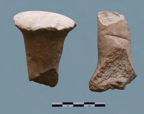
40 Fig. 15: Tell Nader. Obsidian lithics. Fig. 16: Tell Nader. Clay animal figurine. Fig. 17: Tell Nader. Clay animal figurine. Fig. 18: Tell Nader. Clay nail.


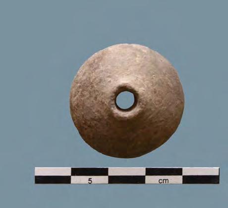
41 Fig. 19: Tell Nader. Gaming piece? Fig. 20: Tell Nader. Gaming piece? Fig. 21: Tell Nader. Spindle whorl. Fig. 22: Tell Nader. Jar stopper.
42 Fig. 23: Tell Nader Pottery. Drawings: Claudia Beuger.
43 Fig. 24: Tell Nader Pottery. Drawings: Claudia Beuger.


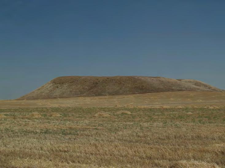
44 Fig. 23: Tell Baqrta. Fig. 24: Tell Baqrta. Fig. 25: Tell Baqrta.
Tepe Gawra, Iraq expedition records
 Tepe Gawra, Iraq expedition records 1021 Last updated on March 02, 2017. University of Pennsylvania, Penn Museum Archives July 2009 Tepe Gawra, Iraq expedition records Table of Contents Summary Information...
EXCAVATIONS AT SUREZHA (ERBIL PLAIN, KURDISTAN REGION, IRAQ)
") EXCAVATIONS AT SUREZHA (ERBIL PLAIN, KURDISTAN REGION, IRAQ) Gil J. Stein and Abbas Alizadeh Project Focus: The Origins of Towns and Social Complexity in Northern Mesopotamia in the Chalcolithic Period
EXCAVATIONS AT SUREZHA (ERBIL PLAIN, KURDISTAN REGION, IRAQ) Gil J. Stein and Abbas Alizadeh Project Focus: The Origins of Towns and Social Complexity in Northern Mesopotamia in the Chalcolithic Period
The lithic assemblage from Kingsdale Head (KH09)
") 1 The lithic assemblage from Kingsdale Head (KH09) Hannah Russ Introduction During excavation the of potential Mesolithic features at Kingsdale Head in 2009 an assemblage of flint and chert artefacts were
1 The lithic assemblage from Kingsdale Head (KH09) Hannah Russ Introduction During excavation the of potential Mesolithic features at Kingsdale Head in 2009 an assemblage of flint and chert artefacts were
Test-Pit 3: 31 Park Street (SK )
") -Pit 3: 31 Park Street (SK 40732 03178) -Pit 3 was excavated in a flower bed in the rear garden of 31 Park Street, on the northern side of the street and west of an alleyway leading to St Peter s Church,
-Pit 3: 31 Park Street (SK 40732 03178) -Pit 3 was excavated in a flower bed in the rear garden of 31 Park Street, on the northern side of the street and west of an alleyway leading to St Peter s Church,
DEMARCATION OF THE STONE AGES.
 20 HAMPSHIRE FLINTS. DEMARCATION OF THE STONE AGES. BY W, DALE, F.S.A., F.G.S. (Read before the Anthropological Section of -the British Association for the advancement of Science, at Birmingham, September
The Chalcolithic in the Near East: Mesopotamia and the Levant
 The Chalcolithic in the Near East: Mesopotamia and the Levant Prof. Susan Pollock Institut für Vorderasiatische Archäologie, Freie Universität Berlin Department of Anthropology, Binghamton University Chronological
Evidence for the use of bronze mining tools in the Bronze Age copper mines on the Great Orme, Llandudno
 Evidence for the use of bronze mining tools in the Bronze Age copper mines on the Great Orme, Llandudno Background The possible use of bronze mining tools has been widely debated since the discovery of
Tell Shiyukh Tahtani (North Syria)
") Tell Shiyukh Tahtani (North Syria) Report of the 2010 excavation season conducted by the University of Palermo Euphrates Expedition by Gioacchino Falsone and Paola Sconzo In the summer 2010 the University
Tell Shiyukh Tahtani (North Syria) Report of the 2010 excavation season conducted by the University of Palermo Euphrates Expedition by Gioacchino Falsone and Paola Sconzo In the summer 2010 the University
IRAN. Bowl Northern Iran, Ismailabad Chalcolithic, mid-5th millennium B.C. Pottery (65.1) Published: Handbook, no. 10
 Published: Handbook, no. 10") Bowl Northern Iran, Ismailabad Chalcolithic, mid-5th millennium B.C. Pottery (65.1) IRAN Published: Handbook, no. 10 Bowl Iran, Tepe Giyan 2500-2000 B.C. Pottery (70.39) Pottery, which appeared in Iran
Bowl Northern Iran, Ismailabad Chalcolithic, mid-5th millennium B.C. Pottery (65.1) IRAN Published: Handbook, no. 10 Bowl Iran, Tepe Giyan 2500-2000 B.C. Pottery (70.39) Pottery, which appeared in Iran
An archaeological evaluation at 16 Seaview Road, Brightlingsea, Essex February 2004
 An archaeological evaluation at 16 Seaview Road, Brightlingsea, Essex February 2004 report prepared by Kate Orr on behalf of Highfield Homes NGR: TM 086 174 (c) CAT project ref.: 04/2b ECC HAMP group site
Lanton Lithic Assessment
 Lanton Lithic Assessment Dr Clive Waddington ARS Ltd The section headings in the following assessment report refer to those in the Management of Archaeological Projects (HBMC 1991), Appendix 4. 1. FACTUAL
Colchester Archaeological Trust Ltd. A Fieldwalking Survey at Birch, Colchester for ARC Southern Ltd
 Colchester Archaeological Trust Ltd A Fieldwalking Survey at Birch, Colchester for ARC Southern Ltd November 1997 CONTENTS page Summary... 1 Background... 1 Methods... 1 Retrieval Policy... 2 Conditions...
Excavations at Shikarpur, Gujarat
 Excavations at Shikarpur, Gujarat 2008-2009 The Department of Archaeology and Ancient History, the M. S. University of Baroda continued excavations at Shikarpur in the second field season in 2008-09. In
Chapter 2. Remains. Fig.17 Map of Krang Kor site
 Chapter 2. Remains Section 1. Overview of the Survey Area The survey began in January 2010 by exploring the site of the burial rootings based on information of the rooted burials that was brought to the
New Composting Centre, Ashgrove Farm, Ardley, Oxfordshire
 New Composting Centre, Ashgrove Farm, Ardley, Oxfordshire An Archaeological Watching Brief For Agrivert Limited by Andrew Weale Thames Valley Archaeological Services Ltd Site Code AFA 09/20 August 2009
3. The new face of Bronze Age pottery Jacinta Kiely and Bruce Sutton
 3. The new face of Bronze Age pottery Jacinta Kiely and Bruce Sutton Illus. 1 Location map of Early Bronze Age site at Mitchelstown, Co. Cork (based on the Ordnance Survey Ireland map) A previously unknown
Human remains from Estark, Iran, 2017
 Bioarchaeology of the Near East, 11:84 89 (2017) Short fieldwork report Human remains from Estark, Iran, 2017 Arkadiusz Sołtysiak *1, Javad Hosseinzadeh 2, Mohsen Javeri 2, Agata Bebel 1 1 Department of
As already observed in 2016, the assemblage from Levels 1-3 of Trench D at Logardan
 Chalcolithic Ceramics from Logardan Trenches D and E: morpho-stylistic features and regional parallels Johnny Samuele Baldi As already observed in 2016, the assemblage from Levels 1-3 of Trench D at Logardan
I MADE THE PROBLEM UP,
 This assignment will be due Thursday, Oct. 12 at 10:45 AM. It will be late and subject to the late penalties described in the syllabus after Friday, Oct. 13, at 10:45 AM. Complete submission of this assignment
1996 Figurine Report Naomi Hamilton
 1996 Figurine Report Naomi Hamilton THE FIGURINES AND OTHER SMALL FINDS Naomi Hamilton Some preliminary comments on the distribution of certain types of artefact, with particular attention to the trench
Greater London GREATER LONDON 3/606 (E ) TQ
 TQ") GREATER LONDON City of London 3/606 (E.01.6024) TQ 30358150 1 PLOUGH PLACE, CITY OF LONDON An Archaeological Watching Brief at 1 Plough Place, City of London, London EC4 Butler, J London : Pre-Construct
GREATER LONDON City of London 3/606 (E.01.6024) TQ 30358150 1 PLOUGH PLACE, CITY OF LONDON An Archaeological Watching Brief at 1 Plough Place, City of London, London EC4 Butler, J London : Pre-Construct
Ubaid Society Evidence for Economic & Social Differentiation
 Ubaid Society Evidence for Economic & Social Differentiation Distinctions between houses and temples Tell Abada Major differences in artefacts between houses Susa (Late Ubaid, 10 ha) 10 m tall platform
39, Walnut Tree Lane, Sudbury (SUY 073) Planning Application No. B/04/02019/FUL Archaeological Monitoring Report No. 2005/112 OASIS ID no.
 Planning Application No. B/04/02019/FUL Archaeological Monitoring Report No. 2005/112 OASIS ID no.") 39, Walnut Tree Lane, Sudbury (SUY 073) Planning Application No. B/04/02019/FUL Archaeological Monitoring Report No. 2005/112 OASIS ID no. 9273 Summary Sudbury, 39, Walnut Tree Lane, Sudbury (TL/869412;
39, Walnut Tree Lane, Sudbury (SUY 073) Planning Application No. B/04/02019/FUL Archaeological Monitoring Report No. 2005/112 OASIS ID no. 9273 Summary Sudbury, 39, Walnut Tree Lane, Sudbury (TL/869412;
ST PATRICK S CHAPEL, ST DAVIDS PEMBROKESHIRE 2015
 ST PATRICK S CHAPEL, ST DAVIDS PEMBROKESHIRE 2015 REPORT FOR THE NINEVEH CHARITABLE TRUST THE UNIVERSITY OF SHEFFIELD AND DYFED ARCHAEOLOGICAL TRUST Introduction ST PATRICK S CHAPEL, ST DAVIDS, PEMBROKESHIRE,
Peace Hall, Sydney Town Hall Results of Archaeological Program (Interim Report)
") Results of Archaeological Program (Interim Report) Background The proposed excavation of a services basement in the western half of the Peace Hall led to the archaeological investigation of the space in
Results of Archaeological Program (Interim Report) Background The proposed excavation of a services basement in the western half of the Peace Hall led to the archaeological investigation of the space in
Cambridge Archaeology Field Group. Fieldwalking on the Childerley Estate, Cambridgeshire. Autumn 2014 to Spring Third interim report
 Cambridge Archaeology Field Group Fieldwalking on the Childerley Estate, Cambridgeshire Autumn 2014 to Spring 2015 Third interim report Summary Field walking on the Childerley estate of Martin Jenkins
Burrell Orchard 2014: Cleveland Archaeological Society Internship Amanda Ponomarenko The Ohio State University June - August 2014
 1 Burrell Orchard 2014: Cleveland Archaeological Society Internship Amanda Ponomarenko The Ohio State University June - August 2014 Selected for the 2014 Cleveland Archaeological Society Internship in
Drills, Knives, and Points from San Clemente Island
 Drills, Knives, and Points from San Clemente Island Frank W. Wood Limited numbers of chipped stone artifacts that might be called finished forms were recovered from the 3- excavations by UCLA. These artifacts
Fieldwalking at Cottam 1994 (COT94F)
") Fieldwalking at Cottam 1994 (COT94F) Tony Austin & Elizabeth Jelley (19 Jan 29) 1. Introduction During the winter of 1994 students from the Department of Archaeology at the University of York undertook
Fieldwalking at Cottam 1994 (COT94F) Tony Austin & Elizabeth Jelley (19 Jan 29) 1. Introduction During the winter of 1994 students from the Department of Archaeology at the University of York undertook
7. Prehistoric features and an early medieval enclosure at Coonagh West, Co. Limerick Kate Taylor
 7. Prehistoric features and an early medieval enclosure at Coonagh West, Co. Limerick Kate Taylor Illus. 1 Location of the site in Coonagh West, Co. Limerick (based on the Ordnance Survey Ireland map)
Xian Tombs of the Qin Dynasty
 Xian Tombs of the Qin Dynasty By History.com, adapted by Newsela staff In 221 B.C., Qin Shi Huang became emperor of China, and started the Qin Dynasty. At this time, the area had just emerged from over
An archaeological watching brief and recording at Brightlingsea Quarry, Moverons Lane, Brightlingsea, Essex October 2003
 An archaeological watching brief and recording at Brightlingsea Quarry, Moverons Lane, Brightlingsea, Essex commissioned by Mineral Services Ltd on behalf of Alresford Sand & Ballast Co Ltd report prepared
KNAP OF HOWAR HISTORIC ENVIRONMENT SCOTLAND STATEMENT OF SIGNIFICANCE. Property in Care (PIC) ID: PIC301 Designations:
 ID: PIC301 Designations:") Property in Care (PIC) ID: PIC301 Designations: Scheduled Monument (SM90195) Taken into State care: 1954 (Guardianship) Last reviewed: 2004 HISTORIC ENVIRONMENT SCOTLAND STATEMENT OF SIGNIFICANCE KNAP
Property in Care (PIC) ID: PIC301 Designations: Scheduled Monument (SM90195) Taken into State care: 1954 (Guardianship) Last reviewed: 2004 HISTORIC ENVIRONMENT SCOTLAND STATEMENT OF SIGNIFICANCE KNAP
When does excavation not require the diggers. One of Iraq s Earliest Towns EXCAVATING TEPE GAWRA IN THE ARCHIVES OF THE UNIVERSITY OF PENNSYLVANIA
 EXCAVATING TEPE GAWRA IN THE ARCHIVES OF THE UNIVERSITY OF PENNSYLVANIA MUSEUM By Brian Peasnall and Mitchell S. Rothman One of Iraq s Earliest Towns TOP: Field chit. MIDDLE: Greater Mesopotamia in the
THE RAVENSTONE BEAKER
 DISCOVERY THE RAVENSTONE BEAKER K. J. FIELD The discovery of the Ravenstone Beaker (Plate Xa Fig. 1) was made by members of the Wolverton and District Archaeological Society engaged on a routine field
Control ID: Years of experience: Tools used to excavate the grave: Did the participant sieve the fill: Weather conditions: Time taken: Observations:
 Control ID: Control 001 Years of experience: No archaeological experience Tools used to excavate the grave: Trowel, hand shovel and shovel Did the participant sieve the fill: Yes Weather conditions: Flurries
Available through a partnership with
 The African e-journals Project has digitized full text of articles of eleven social science and humanities journals. This item is from the digital archive maintained by Michigan State University Library.
Church of St Peter and St Paul, Great Missenden, Buckinghamshire
 Church of St Peter and St Paul, Great Missenden, Buckinghamshire An Archaeological Watching Brief for the Parish of Great Missenden by Andrew Taylor Thames Valley Archaeological Services Ltd Site Code
MARSTON MICHAEL FARLEY
 MARSTON MICHAEL FARLEY On 9 March agricultural contractors, laying field drains for Bucks County Council Land Agent's Department, cut through a limestone structure at SP 75852301 in an area otherwise consistently
Unit 3 Hair as Evidence
 Unit 3 Hair as Evidence A. Hair as evidence a. Human hair is one of the most frequently pieces of evidence at the scene of a violent crime. Unfortunately, hair is not the best type of physical evidence
1. Presumed Location of French Soundings Looking NW from the banks of the river.
 SG02? SGS SG01? SG4 1. Presumed Location of French Soundings Looking NW from the banks of the river. The presumed location of SG02 corresponds to a hump known locally as the Sheikh's tomb. Note also (1)
ARCHAEOLOGICAL EVALUATION AT BRIGHTON POLYTECHNIC, NORTH FIELD SITE, VARLEY HALLS, COLDEAN LANE, BRIGHTON. by Ian Greig MA AIFA.
 ARCHAEOLOGICAL EVALUATION AT BRIGHTON POLYTECHNIC, NORTH FIELD SITE, VARLEY HALLS, COLDEAN LANE, BRIGHTON by Ian Greig MA AIFA May 1992 South Eastern Archaeological Services Field Archaeology Unit White
Moray Archaeology For All Project
 School children learning how to identify finds. (Above) A flint tool found at Clarkly Hill. Copyright: Leanne Demay Moray Archaeology For All Project ational Museums Scotland have been excavating in Moray
Specialist Report 11 Worked Flint by Hugo Anderson-Whymark
 London Gateway Iron Age and Roman Salt Making in the Thames Estuary Excavation at Stanford Wharf Nature Reserve, Essex Specialist Report 11 Worked Flint by Hugo Anderson-Whymark Specialist Report 11 Worked
1 Introduction to the Collection
 Shahrokh Razmjou Center of Achaemenid Studies National Museum of Iran (Tehran) Project Report of the Persepolis Fortification Tablets in the National Museum of Iran 1 Introduction to the Collection During
Archaeological Material From Spa Ghyll Farm, Aldfield
 Archaeological Material From Spa Ghyll Farm, Aldfield Introduction Following discussions with Linda Smith the Rural Archaeologist for North Yorkshire County Council, Robert Morgan of 3D Archaeological
Monitoring Report No. 99
 Monitoring Report No. 99 Enniskillen Castle Co. Fermanagh AE/06/23 Cormac McSparron Site Specific Information Site Name: Townland: Enniskillen Castle Enniskillen SMR No: FER 211:039 Grid Ref: County: Excavation
oi.uchicago.edu tell zeidan Gil J. Stein
 Gil J. Stein 2010 Field Work The third field season of the joint Syrian-American excavations at Tell Zeidan, in the Euphrates River valley of north central Syria, was conducted from July 10 to August 8,
St Germains, Tranent, East Lothian: the excavation of Early Bronze Age remains and Iron Age enclosed and unenclosed settlements
 Proc Soc Antiq Scot, 128 (1998), 203-254 St Germains, Tranent, East Lothian: the excavation of Early Bronze Age remains and Iron Age enclosed and unenclosed settlements Derek Alexander* & Trevor Watkinsf
MUSEUM LffiRARY. George C. Vaillant Book Fund
 MUSEUM LffiRARY UNIVERSITY OF PENNSYLVANIA George C. Vaillant Book Fund AN EARLY VILLAGE SITE AT ZAWI CHEMI SHANIDAR UNDENA PUBLICATIONS MALIBU 1981 23tbliotl)cca ruceepctamlca PrimaJY sources and interpretive
An archaeological evaluation at the Lexden Wood Golf Club (Westhouse Farm), Lexden, Colchester, Essex
, Lexden, Colchester, Essex") An archaeological evaluation at the Lexden Wood Golf Club (Westhouse Farm), Lexden, Colchester, Essex January 2000 Archive report on behalf of Lexden Wood Golf Club Colchester Archaeological Trust 12 Lexden
An archaeological evaluation at the Lexden Wood Golf Club (Westhouse Farm), Lexden, Colchester, Essex January 2000 Archive report on behalf of Lexden Wood Golf Club Colchester Archaeological Trust 12 Lexden
Medieval Burials and the Black Death
 Medieval Burials and the Black Death A Report on Badia Pozzeveri, Italy Bioarchaeology Field School Summer 2015 During the summer of 2015, I was given the opportunity to participate in the Ohio State University/Universitá
1 The East Oxford Archaeology and History Project
 1 The East Oxford Archaeology and History Project EXOP TEST PIT 72 Location: Bartlemas Chapel, Cowley Date of excavation: 6-8 November 2013. Area of excavation: 0.8m x 1.2m, at the eastern end of the chapel.
The lab Do not wash metal gently Never, ever, mix finds from different layers
 8 The lab 8.1 Finds processing The finds from the excavations at all parts of the site are brought down at the end of the day to the lab in the dig house. Emma Blake oversees the processing. Monte Polizzo
FEATURE DESCRIPTIONS: PART 1. SAN AGUSTÍN MISSION LOCUS, THE CLEARWATER SITE, AZ BB:13:6 (ASM)
") CHAPTER 4 FEATURE DESCRIPTIONS: PART 1. SAN AGUSTÍN MISSION LOCUS, THE CLEARWATER SITE, AZ BB:13:6 (ASM) Thomas Klimas, Caramia Williams, and J. Homer Thiel Desert Archaeology, Inc. Archaeological work
CHAPTER 4 FEATURE DESCRIPTIONS: PART 1. SAN AGUSTÍN MISSION LOCUS, THE CLEARWATER SITE, AZ BB:13:6 (ASM) Thomas Klimas, Caramia Williams, and J. Homer Thiel Desert Archaeology, Inc. Archaeological work
Tips for proposers. Cécile Huet, PhD Deputy Head of Unit A1 Robotics & AI European Commission. Robotics Brokerage event 5 Dec Cécile Huet 1
 Tips for proposers Cécile Huet, PhD Deputy Head of Unit A1 Robotics & AI European Commission Robotics Brokerage event 5 Dec. 2016 Cécile Huet 1 What are you looking for? MAXIMISE IMPACT OF PROGRAMME on
SALVAGE EXCAVATIONS AT OLD DOWN FARM, EAST MEON
 Proc. Hants. Field Club Archaeol. Soc. 36, 1980, 153-160. 153 SALVAGE EXCAVATIONS AT OLD DOWN FARM, EAST MEON By RICHARD WHINNEY AND GEORGE WALKER INTRODUCTION The site was discovered by chance in December
THE PRE-CONQUEST COFFINS FROM SWINEGATE AND 18 BACK SWINEGATE
 THE PRE-CONQUEST COFFINS FROM 12 18 SWINEGATE AND 18 BACK SWINEGATE An Insight Report By J.M. McComish York Archaeological Trust for Excavation and Research (2015) Contents 1. INTRODUCTION... 3 2. THE
An early pot made by the Adena Culture (800 B.C. - A.D. 100)
") Archaeologists identify the time period of man living in North America from about 1000 B.C. until about 700 A.D. as the Woodland Period. It is during this time that a new culture appeared and made important
Archaeologists identify the time period of man living in North America from about 1000 B.C. until about 700 A.D. as the Woodland Period. It is during this time that a new culture appeared and made important
 While every reasonable attempt has been made to obtain permission to use the images reproduced in this article, it has not been possible to trace or contact the respective copyright holders. There has
Artifacts. Antler Tools
 Artifacts Artifacts are the things that people made and used. They give a view into the past and a glimpse of the ingenuity of the people who lived at a site. Artifacts from the Tchefuncte site give special
Azerbaijan National Academy of Sciences Institute of Archaeology and Ethnography. Safar Ashurov
 Azerbaijan National Academy of Sciences Institute of Archaeology and Ethnography Safar Ashurov Zayamchay Report On Excavations of a Catacomb Burial At Kilometre Point 355 of Baku-Tbilisi-Ceyhan and South
Censer Symbolism and the State Polity in Teotihuacán
 FAMSI 2002: Saburo Sugiyama Censer Symbolism and the State Polity in Teotihuacán Research Year: 1998 Culture: Teotihuacán Chronology: Late Pre-Classic to Late Classic Location: Highland México Site: Teotihuacán
16 members of the Fieldwalking Group met York Community Archaeologist Jon Kenny at Lou Howard s farm, Rose Cottage Farm, at
 Terrington History Group Fieldwalking Group Field 1 Final report 21 October 2011 - fieldwalking 16 members of the Fieldwalking Group met York Community Archaeologist Jon Kenny at Lou Howard s farm, Rose
Life and Death at Beth Shean
 Life and Death at Beth Shean by emerson avery Objects associated with daily life also found their way into the tombs, either as offerings to the deceased, implements for the funeral rites, or personal
Chapter 2: Archaeological Description
 Chapter 2: Archaeological Description Phase 1 Late Neolithic, c 3000-2400 BC (Figs 6-9) Evidence of Neolithic activity was confined to pits dug across the southern half of the site (Fig. 6). Eighteen pits
Novington, Plumpton East Sussex
 Novington, Plumpton East Sussex The Flint Over 1000 pieces of flintwork were recovered during the survey, and are summarised in Table 0. The flint is of the same types as found in the previous survey of
PLEISTOCENE ART OF THE WORLD
 PROCEEDINGS OF THE IFRAO CONGRESS September 2010 2013 # 5 http://www.palethnologie.org ISSN 2108-6532 directed by Jean CLOTTES PLEISTOCENE ART OF THE WORLD Short articles Revue bilingue de Préhistoire
2 Saxon Way, Old Windsor, Berkshire
 2 Saxon Way, Old Windsor, Berkshire An Archaeological Watching Brief For Mrs J. McGillicuddy by Pamela Jenkins Thames Valley Archaeological Services Ltd Site Code SWO 05/67 August 2005 Summary Site name:
An archaeological evaluation at the Blackwater Hotel, Church Road, West Mersea, Colchester, Essex March 2003
 An archaeological evaluation at the Blackwater Hotel, Church Road, West Mersea, Colchester, Essex report prepared by Laura Pooley on behalf of Dolphin Developments (U.K) Ltd NGR: TM 0082 1259 CAT project
STONE implements and pottery indicative of Late Neolithic settlement are known to
 Late Neolithic Site in the Extreme Northwest of the New Territories, Hong Kong Received 29 July 1966 T. N. CHIU* AND M. K. WOO** THE SITE STONE implements and pottery indicative of Late Neolithic settlement
STONES OF STENNESS HISTORIC ENVIRONMENT SCOTLAND STATEMENT OF SIGNIFICANCE
 Property in Care (PIC) ID: PIC321 Designations: Scheduled Monument (SM90285); Taken into State care: 1906 (Guardianship) Last reviewed: 2003 HISTORIC ENVIRONMENT SCOTLAND STATEMENT OF SIGNIFICANCE STONES
Ancient Mesopotamia and the Sumerians (Room 56)
") Ancient Mesopotamia and the Sumerians (Room 56) The Sumerians are thought to have formed the first human civilization in world history. They lived in southern Mesopotamia, between the Tigris and Euphrates
Ancient Mesopotamia and the Sumerians (Room 56) The Sumerians are thought to have formed the first human civilization in world history. They lived in southern Mesopotamia, between the Tigris and Euphrates
AN INVESTIGATION OF LINTING AND FLUFFING OF OFFSET NEWSPRINT. ;, l' : a Progress Report MEMBERS OF GROUP PROJECT Report Three.
 ;, l' : Institute of Paper Science and Technology. ' i,'',, AN INVESTIGATION OF LINTING AND FLUFFING OF OFFSET NEWSPRINT, Project 2979 : Report Three a Progress Report : r ''. ' ' " to MEMBERS OF GROUP
Section Worked stone catalogue By Hugo Anderson-Whymark
 Section 4.11.2 Worked stone catalogue By Hugo Anderson-Whymark Table 4.67: Worked stone from Alfred s Castle. TR Ctxt SF No 1 1000 0 Weaponry Sling-shot Flint pebble 100 1 57 43 37 27 Iron Age 1 1160 0
The Euphrates Valley Expedition
 The Euphrates Valley Expedition HANS G. GUTERBOCK, Director MAURITS VAN LOON, Field Director For the third consecutive year we have spent almost three months digging at Korucutepe, the site assigned to
Scientific evidences to show ancient lead trade with Tissamaharama Sri Lanka: A metallurgical study
 Scientific evidences to show ancient lead trade with Tissamaharama Sri Lanka: A metallurgical study Arjuna Thantilage Senior Lecturer, Coordinator, Laboratory for Cultural Material Analysis (LCMA), Postgraduate
HANT3 FIELD CLUB AND ARCH^OLOGICAL SOCIETY, PLATE 4
 HANT3 FIELD CLUB AND ARCH^OLOGICAL SOCIETY, 1898. PLATE 4 VUU*. ilurti.14 HALF SIZE. BRONZE PALSTAVES, FOUND AT PEAR TREE GREEN. n BRONZE IMPLEMENTS FROM THE. NEIGHBOURHOOD OF SOUTHAMPTON, BY W. DALE,
Preliminary Report on the Second Season of Excavations conducted on Mis Island (AKSC)
") Preliminary Report on the Second Season of Excavations conducted on Mis Island (AKSC) Andrew Ginns During the 2005-06 season of fieldwork carried out on Mis Island, 1 exhumations from three separate medieval
Preliminary Report on the Second Season of Excavations conducted on Mis Island (AKSC) Andrew Ginns During the 2005-06 season of fieldwork carried out on Mis Island, 1 exhumations from three separate medieval
Bioarchaeology of the Near East 3:47 51 (2009) Short Fieldwork Report: Gohar Tepe (Iran), season 2009 A. Sołtysiak, A. Mahfroozi
 Short Fieldwork Report: Gohar Tepe (Iran), season 2009 A. Sołtysiak, A. Mahfroozi") Bioarchaeology of the Near East 3:47 51 (2009) Short Fieldwork Report: Gohar Tepe (Iran), season 2009 A. Sołtysiak, A. Mahfroozi (published online on www.anthropology.uw.edu.pl) Short Fieldwork Reports
Bioarchaeology of the Near East 3:47 51 (2009) Short Fieldwork Report: Gohar Tepe (Iran), season 2009 A. Sołtysiak, A. Mahfroozi (published online on www.anthropology.uw.edu.pl) Short Fieldwork Reports
A Summer of Surprises: Gezer Water System Excavation Uncovers Possible New Date. Fig. 1, Gezer Water System
 Can You Dig It A Summer of Surprises: Gezer Water System Excavation Uncovers Possible New Date Posted: 14 Sep 2016 07:29 AM PDT By Dan Warner and Eli Yannai, Co-Directors of the Gezer Water System Excavations
An archaeological watching brief at Sheepen, Colchester, Essex November-December 2003
 An archaeological watching brief at Sheepen, Colchester, Essex November-December 2003 report prepared by Ben Holloway on behalf of Colchester Borough Council CAT project ref.: 03/11c Colchester Museums
FURTHER MIDDLE SAXON EVIDENCE AT COOK STREET, SOUTHAMPTON (SOU 567)
") Roc. Hampshire Field Club Archaeol. Soc 52,1997, 77-87 (Hampshire Studies 1997) FURTHER MIDDLE SAXON EVIDENCE AT COOK STREET, SOUTHAMPTON (SOU 567) By M F GARNER andj VINCENT with a contribution byjacqueline
Roc. Hampshire Field Club Archaeol. Soc 52,1997, 77-87 (Hampshire Studies 1997) FURTHER MIDDLE SAXON EVIDENCE AT COOK STREET, SOUTHAMPTON (SOU 567) By M F GARNER andj VINCENT with a contribution byjacqueline
NOTE A THIRD CENTURY ROMAN BURIAL FROM MANOR FARM, HURSTBOURNE PRIORS. by. David Allen with contributions by Sue Anderson and Brenda Dickinson
 Proc. Hampsh. Field Club Archaeol. Soc. 47, 1991, 253-257 NOTE A THIRD CENTURY ROMAN BURIAL FROM MANOR FARM, HURSTBOURNE PRIORS Abstract by. David Allen with contributions by Sue Anderson and Brenda Dickinson
3.4 The prehistoric lithic assemblage by I.P. Brooks. Introduction. Raw materials. Distribution
 3.4 The prehistoric lithic assemblage by I.P. Brooks Introduction A total of 1656 flint and chert artefacts were recovered during the excavations at Fullerton. The majority of these were found in two trenches,
December 6, Paul Racher (P007) Archaeological Research Associates Ltd. 900 Guelph St. Kitchener ON N2H 5Z6
 Archaeological Research Associates Ltd. 900 Guelph St. Kitchener ON N2H 5Z6") Ministry of Tourism, Culture and Sport Culture Programs Unit Programs and Services Branch Culture Division 401 Bay Street, Suite 1700 Toronto ON M7A 0A7 Tel.: 416-314-2120 Ministère du Tourisme, de la
Ministry of Tourism, Culture and Sport Culture Programs Unit Programs and Services Branch Culture Division 401 Bay Street, Suite 1700 Toronto ON M7A 0A7 Tel.: 416-314-2120 Ministère du Tourisme, de la
Grim s Ditch, Starveall Farm, Wootton, Woodstock, Oxfordshire
 Grim s Ditch, Starveall Farm, Wootton, Woodstock, Oxfordshire An Archaeological Recording Action For Empire Homes by Steve Ford Thames Valley Archaeological Services Ltd Site Code SFW06/118 November 2006
History Ch-4 (W.B Answer Key) Pakistan 2. The bricks were laid in an interlocking pattern and that made the walls strong.
 Pakistan 2. The bricks were laid in an interlocking pattern and that made the walls strong.") History Ch-4 (W.B Answer Key) W.B (pp-42, 43) 1. The site of Harappa is in the present day Pakistan. 2. How were the bricks of ancient settlement used? The bricks were laid in an interlocking pattern and
History Ch-4 (W.B Answer Key) W.B (pp-42, 43) 1. The site of Harappa is in the present day Pakistan. 2. How were the bricks of ancient settlement used? The bricks were laid in an interlocking pattern and
Silwood Farm, Silwood Park, Cheapside Road, Ascot, Berkshire
 Silwood Farm, Silwood Park, Cheapside Road, Ascot, Berkshire An Archaeological Watching Brief For Imperial College London by Tim Dawson Thames Valley Archaeological Services Ltd Site Code SFA 09/10 April
January 13 th, 2019 Sample Current Affairs
 January 13 th, 2019 Sample Current Affairs 1. Harappa grave of ancient 'couple' reveals secrets of Marriage What are the key takeaways of the excavation? Was marriage legally accepted in Harappan society?
Limited Archaeological Testing at the Sands House Annapolis, Maryland
 Limited Archaeological Testing at the Sands House Annapolis, Maryland Report Submitted to Four Rivers Heritage Area by John E. Kille, Ph.D., Shawn Sharpe, and Al Luckenbach, Ph.D February 10, 2012 In May-June
2010 Watson Surface Collection
 2010 Watson Surface Collection Carol Cowherd Charles County Archaeological Society of Maryland, Inc. Chapter of Archeological Society of Maryland, Inc. November 2010 2011 Charles County Archaeological
Opium Cabin excavation Passport In Time July 21-25, 2014
 Opium Cabin excavation Passport In Time July 21-25, 2014 Page 1 of 14 Non-American Indian settlement of the southern Blue Mountains began with the discovery of gold in drainages of the John Day River in
THE EXCAVATION OF A BURNT MOUND AT HARBRIDGE, HAMPSHIRE
 Proc Hampshire Field ClubArchaeolSoc5i, 1999,172-179 (Hampshire Studies 1999) THE EXCAVATION OF A BURNT MOUND AT HARBRIDGE, HAMPSHIRE by S J SHENNAN ABSTRACT A burnt mound of Late Brome Age date, as indicated
Report to the Arizona Archaeological and Historical Society on Jakob W. Sedig s Trip to Fife Lake, Michigan to Assess Archaeological Collections
 Report to the Arizona Archaeological and Historical Society on Jakob W. Sedig s Trip to Fife Lake, Michigan to Assess Archaeological Collections This report details the trip I took to Fife Lake, Michigan
Inadvertent Discovery Plan (IDP)
") Inadvertent Discovery Plan (IDP) Permit Number: Project Name: Applicant: Property Address: As the project proponent, I have read this document in full and understand that: 1. I will follow the actions
Inadvertent Discovery Plan (IDP) Permit Number: Project Name: Applicant: Property Address: As the project proponent, I have read this document in full and understand that: 1. I will follow the actions
Archaeological sites and find spots in the parish of Burghclere - SMR no. OS Grid Ref. Site Name Classification Period
 Archaeological sites and find spots in the parish of Burghclere - SMR no. OS Grid Ref. Site Name Classification Period SU45NE 1A SU46880 59200 Ridgemoor Farm Inhumation Burial At Ridgemoor Farm, on the
HISTORY. Subject : History (For under graduate student) Topic No. & Title : Unit- 4 Indus Civilization Topic- c Chalcolithic Cultures of India
 Topic No. & Title : Unit- 4 Indus Civilization Topic- c Chalcolithic Cultures of India") HISTORY Subject : History (For under graduate student) Paper No. : Paper-I History of India Topic No. & Title : Unit- 4 Indus Civilization Topic- c Chalcolithic Cultures of India Lecture No. & Title :
HISTORY Subject : History (For under graduate student) Paper No. : Paper-I History of India Topic No. & Title : Unit- 4 Indus Civilization Topic- c Chalcolithic Cultures of India Lecture No. & Title :
Tools, Customs, and Daily Schedule
 Mr. Carlson Room 107 7 C World Cultures Going on a Dig Tools, Customs, and Daily Schedule Tools The most common tools archaeologists use are the hand trowel, hand pick, brush, dental tools (for delicate
Gil J. Stein Excavations and Laboratory Work
 2009 Excavations and Laboratory Work Tell Zeidan Gil J. Stein In the summer of 2009, the Oriental Institute conducted the second field season of excavations in the joint Syrian-American archaeological