Archaeological Evaluation Report
|
|
|
- Geraldine Judith Walters
- 5 years ago
- Views:
Transcription

1 Archaeological Test Pit Evaluation Report April 2015 Client: Jeremy Newsum OA East Report No: 1760 OASIS No: Oxfordar NGR: TL Archaeological Evaluation Report Test Pit Evaluation at Swavesey Priory Swavesey, Cambridgeshire
2 Test Pit Evaluation at Swavesey Priory, Swavesey, Cambridgeshire Archaeological Test Pit Evaluation By Daria Tsybaeva MA With contributions by Carole Fletcher BA ACIfA and Anthony Haskins BSc PCIfA Editor: Rachel Clarke BA MCIfA Illustrator: Robin Webb BA MA Report Date: April 2015 Oxford Archaeology East Page 1 of 25 Report Number 1760
3
4 Table of Contents Summary Introduction Location and scope of work Geology and topography Archaeological and historical background Acknowledgements Aims and Methodology Aims Methodology Results Introduction Test Pit Test Pit Test Pit Test Pit Test Pit Finds Summary Discussion and Conclusions Discussion Significance Recommendations...16 Appendix A. Trench Descriptions and Context Inventory...17 Appendix B. Finds Reports...19 B.1 Flint...19 B.2 Glass...19 B.3 Pottery...20 B.4 Ceramic Building Material...21 Oxford Archaeology East Page 3 of 25 Report Number 1760
5 Appendix C. Bibliography...22 Appendix D. OASIS Report Form...23 Oxford Archaeology East Page 4 of 25 Report Number 1760
6 List of Figures Fig. 1 Site location showing archaeological test pits Fig. 2 Plan of archaeological test pits Fig. 3 Test pit sections at 1:20 List of Plates Plate 1. View of St Andrews church and priory grounds, viewed from north-east Plate 2. Test Pit 1, viewed from south Plate 3. Test Pit 2, viewed from west Plate 4. Test Pit 3, viewed from east Plate 5. Test Pit 4, viewed from north Plate 6. Test Pit 5, viewed from north Plate 7. Perse Archaeology Group students excavating Test Pit 5, viewed from south Plate 8. Perse Archaeology Group students, viewed from south-west Plate 9. Perse Archaeology Group students excavating Test Pit 4, viewed from south-west Plate 10. Test Pit 5 and St Andrews church, viewed from north-east List of Tables Table 1: Glass Table 2: Pottery Table 3: Ceramic Building Material Oxford Archaeology East Page 5 of 25 Report Number 1760
7 Oxford Archaeology East Page 6 of 25 Report Number 1760
8 Summary In March 2015 Oxford Archaeology East (OA East) undertook a test pit evaluation, on behalf of Jeremy Newsum and English Heritage, on the earthwork remains of Swavesey Priory (SM 38; TL ) in advance of tree planting. Five test pits were excavated: two 1.5m x 1.5m dug by OA East and a further three 1m x 1m test pits were excavated with the help of students and a teacher from Perse Archaeology Group. Test pits were excavated to a depth of between 0.3m and 0.9m and generally encountered layers of topsoil overlying subsoil or similar deposits. The test pits were excavated and backfilled by hand. The natural was not reached during excavation (except possibly in Test Pit 2), and no definite archaeological features were encountered. A few finds of mixed date (prehistoric, Roman, medieval and postmedieval) were retrieved. The thickness of some of the lower deposits and the mixed date of the finds, notably in Test Pit 5, may indicate that the test pits were located within a large feature (or features) such as a ditch or quarry. Quarrying for sand and gravel is known to have occurred in the field during the 19th century, when the Swavesey to Over Road (Station Road) was constructed immediately adjacent to the site, and more recently during the early to mid 20th century. The results indicate that the proposed tree planting is likely to have a minimum effect on any buried archaeology in the area. Oxford Archaeology East Page 7 of 25 Report Number 1760
9 Oxford Archaeology East Page 8 of 25 Report Number 1760
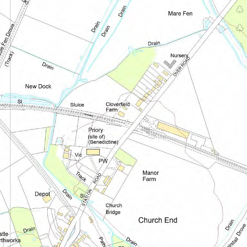
10 1 INTRODUCTION 1.1 Location and scope of work An archaeological test pit evaluation was conducted by OA East in March 2015 at the site of Swavesey Priory (TL ; Fig. 1 and Plate 1), a scheduled monument comprising a complex of earthworks in a pasture field north-east of St Andrews church at the northern end of the village. Five test pits were excavated in the north-east corner of the field, adjacent to the line of the Cambridgeshire Guided Busway This archaeological evaluation was commissioned by English Heritage (EH) and was undertaken in accordance with a Written Scheme of Investigation (WSI) prepared by OA East (Lambert 2015) Swavesey Priory is a Scheduled Monument (SM CB 38, HA ). Any ground works require Scheduled Monument Consent (SMC), which was granted 4/3/15 (Case No. S ) under the 1979 Ancient Monuments and Archaeological Areas Act The project arose due to the need to assess an area of the Scheduled Monument prior to tree planting and to determine the impact these trees might have on the survival of any buried archaeology within the impact zone. The investigation was designed to assess the presence of any archaeological remains to the depth of proposed tree planting. Two test pits were dug by OA East staff and an additional three were excavated by students from Perse Archaeology Group under OA East supervision. Once this was completed to the satisfaction of Cambridgeshire County Council (CCC) and EH, the test pits were then in-filled in order to make the site safe for horses, as the grazing of the field forms part of the conservation management plan put in place to protect the earthworks The site archive is currently held by OA East and will be deposited with the appropriate county stores in due course, although some of the artefacts may form part of a display within the parish church of St Andrews, which lies adjacent to the site. 1.2 Geology and topography The following is based on the Geology and Topography section in Clarke (2014) The parish of Swavesey lies in the south-western hinterland of the fens, c.16km to the north-west of Cambridge. The two-mile long village developed on two 'islands' of terrace gravels which cap a peninsula of Ampthill clay (BGS 1975, sheet 187). These 'uplands' extend into the fen where the Great Ouse valley joins the fen basin. Extensive alluvial deposits exist on either side of the peninsular and define the former extent of the fen prior to drainage. On the eastern side the fen would have formed a wide basin between the villages of Swavesey and Over to the north-east, which occupies a similar topographical position. This basin narrows from c.900m wide to around 100m where the current Swavesey/Over road runs past the church, manor and the priory Swavesey Priory (and the current site) is located on the more northerly (and smaller) of the two islands in an area that would have been a prime fen-edge location for occupation from prehistoric times onwards. A number of major water management features and drains around the village and priory are testament to the effects of flooding in this area. In the medieval period, Swavesey was an inland port served by a dock with a canal that linked to the River Great Ouse to the north The site lies at c.7.5m AOD and is currently a pasture field, adjacent and to the northeast of the parish church of St Andrews; the site of the manor is located to the south- Oxford Archaeology East Page 9 of 25 Report Number 1760
11 east on the other side of Station Road. Within the field there are many upstanding earthworks, which are the remains of the medieval Benedictine Priory and associated features. To the north the site is now bounded by the Guided Busway, while to the east the boundary is formed by Station Road and to the south and west by the parish church and former vicarage. 1.3 Archaeological and historical background Note: This background section was written by R. Clarke and formed the archaeological and historical background section in a previous report on an investigation undertaken at Swavesey Priory in 2012 (Clarke 2014). It was based on a number of published and unpublished sources, notably the Victoria County History (VCH; Salzman (ed) 1948; Wright and Lewis (eds) 1989), Swavesey Priory (The Remains) by M. Bousfield, the draft Historic Towns of Cambridgeshire Extensive Urban Survey (CCC 2001) and the Cambridgeshire Heritage Environment Record (CHER). More detailed accounts of the village, priory and manorial development can be found in these documents Despite its Anglo-Saxon name, derived from the prefix Swaef (a personal name which occurs again in Swaffham) and the suffix meaning 'landing-place' (Reaney 1943, 172), the first documented reference to Swavesey occurs in the Domesday Book At the Norman Conquest it appears that much of Swavesey was held by Edeva the Fair, then passing to Count Alan of Brittany: In Papworth Hundred, the Count holds Swavesey himself. 13 hides. Land for 4 ploughs. In lordship 6 hides; 3 ploughs there; a fourth possible. 10 villagers with 19 smallholders and 8 Freemen hold 3 hides of this land. Together they have 10 ploughs. 17 cottagers; 2 slaves 1 mill at 40s; from fisheries 4,000 eels less 250; meadow for 14 ploughs; pasture for the village livestock. Total value 16; when acquired 8; before In addition to this central manor, two smaller holdings were recorded that were formerly the lands of Robert Gernon and a thane named Ulf; afterwards passing to Picot the Sheriff and Gilbert of Gand As well as being a port town, Swavesey was an administrative centre for a large estate; a weekly market was granted to the lord, Alan de la Zouche, and his heirs in 1244, which was extended to include an annual fair in It was probably at this time that the town defences and streets were laid out. A complex system of docks and a wharf stretching from Swan Pond into the middle of the village at Market Street (Town Pond/dock) was also constructed, with a canal connecting the port to the Great Ouse, which in the medieval period was a major transportation route. Although no borough charter is known to have been granted to Swavesey, burgesses are mentioned in the Hundred Rolls of Swavesey Castle is thought to have been built in the late 11th or early 12th century, although there are no documentary references before 1476; its site (now represented by earthworks; CHER 1772) appears to have subsequently been incorporated into the town defences There have been a number of archaeological investigations within and around the medieval village, notably at Black Horse Lane (MCB11949; Spoerry 1996 etc) where a considerable density of archaeological features, including settlement remains dating to the Late Iron Age, Late Saxon, Saxo-Norman and medieval periods, was revealed. Oxford Archaeology East Page 10 of 25 Report Number 1760
12 Swavesey Priory The priory (CHER 3488), which some believe may have replaced a Saxon minster as a church was in existence on the site in 996, was founded by Alan of Brittany who gave the church at Swavesey, along with other holdings, to the Benedictine Abbey of Saints Sergius and Bacchus at Angers in France. Buildings for the priory appear to have been constructed between Further documentary references to the priory, which was never a large establishment housing just four or five brothers (although see below), include grants, suits and acquisitions during the 12th and early 13th centuries. However, after 1259, when the king of England abandoned claim to sovereignty of Anjou following the Treaty of Paris, there is no evidence that a priory was ever maintained, instead just a single vicar, usually styled prior, appears to have been in residence It has been suggested (Palmer and Parsons 1903, 29-31) that it is 'by no means certain that there ever was a priory at Swavesey in the same sense as there was one at Ely', especially given the lack of specific documentary evidence. These authors suggest that it is more probable that the French mother abbey instituted a monk as Rector at Swavesey to administer the estate, and that there never was a community of monks living under the rule of a Prior here, but rather it was more a 'cell' to the French abbey Swavesey Priory estate is listed in 1279 and in a rental of 1467 but neither source throws any light on the site. The house, along with other alien priories, was briefly seized in the 1350s and again in 1369, when a survey was made that showed how poor the priory was at that time. In 1393 Richard II licensed the abbot of SS Sergius and Bacchus to alienate the manors of Swavesey and Dry Drayton and the advowson of the church of Swavesey to the Carthusian Priory, recently founded in Coventry. The incumbent prior of Swavesey, John Thorndon, released his rights in the priory estates to St Anne's in return for a pension of 10. By 1411 the priory or church of Swavesey was finally appropriated, with the rest of its possessions, by the Carthusians at Coventry who ran the estate as a manor until the Dissolution. In 1539 the king granted the Swavesey and Drayton estates to the Bishop of Ely in exchange for the manor of Hatfield in Hertfordshire (Palmer and Parsons 1903, 31) By 1200, the northern island of Swavesey, where the priory, church and manor were located, was known as 'The Eye'. Although the origin of this name is unclear, it may also derive from the word meaning 'landing-place' (see above). In later centuries this area, which includes the manor to the east of Station Road, is shown as Church End on 19th century maps. The church of St Andrews (CHER 3419) lies to the south of the priory earthworks (Figs 1 and 3), in what may have been a central location within the moated enclosure/precinct. It is considered to have Saxon origins, with a Saxon nave and chancel visible in the south wall, thought to date to c.1000ad. The church is built of field stones, ironstone conglomerate and coarse limestone rubble with ashlar dressings. The nave was rebuilt in 1200 and the church was repeatedly enlarged during the 13th century Little is known of the fate of the priory after the Dissolution. A building on the north side of the church is shown on the 1836 OS 1" map (see Clarke 2014, fig. 3), adjacent to which is the legend 'ruins'. This building may have been the Priory House, mentioned in 1401 when a complaint of theft was lodged by the Carthusians of Coventry. The VCH (1989, 384) indicates that in the 18th century a rectory may have stood to the north of the church and that in about 1800 there was still a fragment of a Gothic building surviving on the north side of the church. No buildings were present in this location in More recent research by Bousfield (1993), however, suggests that the rectory Oxford Archaeology East Page 11 of 25 Report Number 1760
13 may actually have been a building seen on the 1838 Enclosure maps, immediately adjacent to the intersection of the main road and the navigation channel to the south of the church. The rectory was mentioned in 1648 as a dwelling house with barn and outhouses attached; this was bounded along one side by a flood bank which still exists today A local history private publication by J. Shepperson provides a transcript of conversations with local residents recorded by Charles Wood in the early part of the 20th century, relating their memories of Swavesey (many presumably from the 19th century) and includes a couple of points of interest for the current project. A tithe barn is recorded as once standing near to the church tower: a former church warden, Harry Wells, recalled that some of its foundations were revealed when a grave was being dug on that side of the church. A rickyard stood on the other side of the barn and timber from the 'old barn' was taken for use elsewhere by one of the well known 'village worthies' at that time, Robinson Mitham (Wood 2009, 8; 18) All that remains now (besides the church) are a series of fairly well-preserved earthworks within Priory Field, forming a large channel or moat with a northern entranceway, surrounding a central platform within which there are a number of probable building platforms and associated banks. Other more denuded earthworks exist within the garden of the Priory House (a Victorian vicarage) along with the remains of a former dock and canalised watercourse (Church Brook) leading around the priory site to the south and west, linking to the River Ouse to the north. It is worthy of note that some of the earthworks in the Priory Field may be the result of quarrying, probably undertaken during the later part of the 19th century when the Swavesey-Over road (Station Road) was constructed/improved, and possibly during World War 2. A note provided by J. Shepperson records gravel being dug out of the field next to the church in the 1920s or 30s, on the site of the vanished priory. At a depth of one foot the diggers came across a cobbled flooring, a foot below which was another floor, below which were what appeared to be cement tanks filled with ashes. A terracotta-coloured jug was found in amongst the ash; it is apparently now in one of the Cambridge museums. Previous investigations and finds As yet there has been no detailed survey or systematic analysis of the earthworks, (which are shown on the early editions of the Ordnance Survey and on the 1976 OS 1:2500 map), however a geophysical survey undertaken in 1999 apparently indicated the presence of at least one rectangular building on the site, although the results of this survey are unpublished. There have been very few archaeological investigations within the scheduled area or its environs, making the current project all the more significant. One of these was located close to the vicarage (Priory House) and the other in advance of the construction of the Guided Busway at the northern edge of the site. The Priory House evaluation (CB15286; Cooper and Kenney 2001) revealed a bank likely to have been associated with the priory, perhaps relating to a canal and a docking area, in addition to undated and post-medieval features; a fragment of architectural stone was also recovered. Work associated with the construction of the Guided Busway route (CB15757) revealed the undated remains of what may have been a timber building to the north of the track; no archaeological features were identified to the south of the track In 2012 an investigation of the effect of rabbit burrowing (ECB 3813) was conducted by OA East in the Priory field to the north of St Andrews Church, which revealed an area of Oxford Archaeology East Page 12 of 25 Report Number 1760
14 possible medieval floor/hearth, post-dissolution evidence of ditches and dumped deposits and an 18th century brick drain. A significant number of medieval and late medieval finds associated with domestic/culinary and dairying activities was retrieved (Clarke 2014) Related records in the CHER include analysis of aerial photographs which identified possible enclosures, tracks, ponds and moats/ditches that may have been associated with the priory (CHERs 8897 and 9128), but are outside the scheduled area. An aerial photograph taken by the Air Ministry and reproduced in Bousfield's account of the priory apparently shows the remains of a 'circular base which supported an extern Calvary cross' to the immediate north of the church (CHER 3488; Bousfield 1993, 3). Photographs of two carved stone corbels or gargoyles thought to have come from the priory which are now in private gardens in the village are also present within the Cambridgeshire Collection; if these are from a priory building it must have had buildings of some substance Other finds possibly associated with the priory are also documented. A bone spindlewhorl was found in the churchyard (CHER 3421), while stones known to have been taken from the priory site were re-used when the church was restored in At the time of the 1840 enclosure award the Swavesey-Over Road was made permanent, utilising the causeway from the village to the south and a track to the north of the bridge. These works formally separated the manor to the east (CHER 1289) and the church to the west, and also encroached upon the churchyard. As a result of these works, three stone coffins were uncovered; the most complete of which dates to the early 13th century. Other reported finds include pottery, tile, stone and bone found in 1993; the former includes a tubular spouted jug, probably Stamford Ware (late 12thearly 13th century), sherds of Orange Sandy ware (mid 14th-16th century), and parts of a pancheon (medieval-post medieval) (CHER 3488). 1.4 Acknowledgements The excavation was conducted by OA East, under the supervision of English Heritage, provided as part of the management agreement with the site owners, Mr and Mrs Newsum. Thanks are due to the site owners for enabling access to the site and allowing use of an outbuilding for storage of equipment, and to Sarah Poppy (EH) for her advice and input during the test pitting. The project was managed by Stephen Macaulay and directed by James Fairbairn and Daria Tsybaeva, assisted by Rebecca Pridmore. Particular thanks are due to the students of Perse Archaeology Group and their teacher Adrian Roberts for their enthusiasm and help Various specialists warrant acknowledgement for their contributions, notably Anthony Haskins (lithics) and Carole Fletcher (pottery). Oxford Archaeology East Page 13 of 25 Report Number 1760
15 2 AIMS AND METHODOLOGY 2.1 Aims The objective of this evaluation was to determine the extent and nature of archaeological deposits in the north-eastern corner of the field (Figs 1 and 2) within the scheduled site of the priory in advance of tree planting. 2.2 Methodology Following a site meeting between EH And OA East the location of two 1.5m x 1.5m test pits to be excavated by OA East staff and three 1m x 1m test pits to be dug by Perse Archaeology Group was agreed upon. These were to target the area of proposed tree holes All test pits were excavated and backfilled by hand to a maximum depth of 0.9m. The spoil was stored on a layer of terram to protect the underlying grass. The cut turf was stored on the grass next to the test pits to prevent it drying out and was replaced after excavation and backfilling was complete Spoil, exposed surfaces and features were scanned with a metal detector. All metaldetected and hand-collected finds were retained for inspection, other than those which were obviously modern All archaeological features and deposits were recorded using OA East's pro-forma sheets. Trench locations, plans and sections were recorded at appropriate scales and colour and monochrome photographs were taken of all relevant features and deposits As only topsoil and subsoil-type layers were encountered, no environmental samples were taken The test pit area was located within a pasture field covered with short grass. Weather conditions were dry and sunny, slightly windy over the two days of excavations. Oxford Archaeology East Page 14 of 25 Report Number 1760
16 3 RESULTS 3.1 Introduction The results of the evaluation are presented separately for each test pit below. Only layers of topsoil and subsoil-like deposits were encountered; neither the natural (apart from a possible gravel layer in Test Pit 4) or any definite archaeological features or deposits were revealed in any of the test pits (Figs 2-3; Plates 1-9). Further details of the test pits and finds recovered can be found in the Appendices. 3.2 Test Pit Test Pit 1 (Figs 2 and 3, section 1, Plate 2), measuring 1.5m x 1.5m was excavated to a total depth of 0.6m and contained two layers. Topsoil layer 100 was a 0.3m thick dark greyish brown silty sand with very occasional small stones and contained no finds. Below, layer 101 was a mid orangey brown silty sand with occasional small and medium stones and contained two sherds of Late Iron Age pottery. Layer 101 was excavated to a depth of 0.3m. 3.3 Test Pit Test Pit 2 (Figs 2 and 3, section 2, Plate 3), measuring 1.5m x 1.5m, was excavated to a total depth of 0.6m and contained two layers. Topsoil layer 200 was a 0.2m thick greyish brown sandy silt with very occasional small stones and contained no finds. Layer 201 below was a brown silty sand with occasional small stones and roots and contained small flints. Layer 201 was excavated to a depth of 0.4m, below which was a gravelly layer (unnumbered) revealed in one corner that may have been natural. 3.4 Test Pit Test Pit 3 (Figs 2 and 3, section 3, Plate 4), measuring 1m x 1m, was excavated to a total depth of 0.3m and contained two layers. Topsoil layer 300 was a 0.3m thick dark greyish brown silty sand with moderate small stones, occasional flecks of charcoal and contained fragments of medieval pottery and bone. Below this a mid greyish brown silty sand layer (301) with moderate small stones was exposed but not excavated. 3.5 Test Pit Test Pit 4 (Figs 2 and 3, section 4, Plate 5), measuring 1m x 1m was excavated to a total depth of 0.38m and contained two layers. Topsoil layer 400 was a 0.2m thick greyish brown sandy silt with occasional small stones that contained no finds. Below, this was layer 401, a dark yellowish brown silty sand with occasional small stones that contained fragments of post-medieval pottery. Layer 401 was excavated to a depth of 0.18m. 3.6 Test Pit Test Pit 5 (Figs 2 and 3, section 5, Plate 6), measuring 1m x 1m was excavated to a total depth of 0.9m and contained two layers. Topsoil layer 500 was a 0.25m thick dark greyish brown silty sand with occasional small stones and small fragments of charcoal. This layer contained post-medieval pottery, in addition to bone, flint, slag and a fragment of a crucible. Below, layer 501 was a dark yellowish brown silty sand with very occasional small and medium stones that contained a mix of prehistoric finds alongside Roman and medieval pottery. This deposit was excavated to a depth of 0.66m. Oxford Archaeology East Page 15 of 25 Report Number 1760
17 3.7 Finds Summary Seven struck flints were recovered that are likely to be of later prehistoric date; a probable Mesolithic blade was retrieved from layer 501 in Test Pit 5. A total of 15 sherds (0.143kg) of pottery was found, the dates of which span the Neolithic/Early Bronze Age to the 19th century. Two fragments of ceramic building material were retrieved, one being Roman in date with the other being medieval; shards of vessel glass of probable post-medieval to modern date were also found in Test Pit 4. Oxford Archaeology East Page 16 of 25 Report Number 1760
18 4 DISCUSSION AND CONCLUSIONS 4.1 Discussion A layer of topsoil sealing a subsoil-like layer was encountered in all five test pits; the natural was not definitely reached although this may have been represented by a gravelly deposit in the base of Test Pit 2. No definite archaeological features were encountered It should be noted that, given the small size of the test pits, it is possible that the lower layers identified as probable subsoil in some of the test pits may in fact be the fill(s) of a large feature (or features) such as a ditch or quarry. This is perhaps most likely in Test Pit 5, where layer 501 was excavated to a depth of 0.66m (too thick to be a subsoil) but its full extent was not exposed. The field containing the priory remains has been pasture for many centuries (hence the survival of the earthworks), and it is unlikely that such a distinct and thick subsoil would have formed if the area had not been ploughed. It is possible that this particular part of the priory, which lay outside the main moated enclosure, was cultivated in the past, but a more plausible explanation might be that some of the test pits (notably Test Pit 5) were located within a former quarry pit. During the later part of the 19th century the site was heavily quarried for gravel during the construction and improvement of the Swavesey to Over road (Station Road) immediately adjacent to the current site. Local knowledge also suggests that the site may have been quarried again in the 1920s or 1930s and then possibly during World War A relatively small quantity of finds was recovered, comprising flint, pottery and CBM in addition to very modern bone, glass and iron nails (those finds that were obviously modern were recorded and discarded). The pottery recovered is a somewhat surprising mix of Late Neolithic/Early Bronze Age, Roman, medieval and post-medieval/modern sherds. There is a known Roman settlement to the north and west of the priory, however prehistoric pottery is not known from the immediate vicinity. All of the earlier pottery was abraded and clearly redeposited or reworked. This broad range of pottery and other finds (most of which came from the lower layer in Test Pit 5) might be expected if this part of the site had been quarried and subsequently infilled with material from mixed sources. The construction of the adjacent road, and more recently the Guided Busway to the north, may also have caused further disturbance to this area Since this is a sensitive area within the Scheduled Monument, the tree planting should still proceed with caution. 4.2 Significance The test pitting in the north-eastern corner of the field at Swavesey Priory has indicated that the proposed planting of trees is unlikely to have a detrimental impact on archaeological deposits in this area. 4.3 Recommendations Recommendations for any future work based upon this report will be made by English Heritage and the County Archaeology Office. Oxford Archaeology East Page 17 of 25 Report Number 1760
19 APPENDIX A. TRENCH DESCRIPTIONS AND CONTEXT INVENTORY Test Pit 1 General description Orientation - Test pit consists of topsoil and subsoil, no archaeology present. Contexts context no type Width (m) Depth (m) Avg. depth (m) 0.6 Width (m) 1.5 Length (m) 1.5 comment finds date 100 Layer Topsoil Layer Subsoil Test Pit 2 Pottery, flint General description Orientation - Test pit consists of topsoil and subsoil, no archaeology present. Contexts context no type Width (m) Depth (m) Avg. depth (m) 0.6 Width (m) 1.5 Length (m) 1.5 comment finds date 200 Layer Topsoil Layer Subsoil Flint - Test Pit 3 General description Orientation - Test pit consists of topsoil and subsoil, no archaeology present. Contexts context no type Width (m) Depth (m) 300 Layer Topsoil Avg. depth (m) 0.3 Width (m) 1 Length (m) 1 comment finds date Bone, pottery 301 Layer - N/A Subsoil N/A - Test Pit 4 General description Orientation - Test pit consists of topsoil and subsoil, no archaeology present. Contexts Avg. depth (m) 0.38 Width (m) 1 Length (m) 1 context type Width Depth comment finds date - - Oxford Archaeology East Page 18 of 25 Report Number 1760
20 no (m) (m) 400 Layer Topsoil Pottery, Glass 401 Layer Subsoil Pottery - Test Pit 5 General description Orientation - Test pit consists of topsoil and subsoil, no archaeology present. Contexts context no type Width (m) Depth (m) 500 Layer Topsoil 501 Layer Subsoil Avg. depth (m) 0.9 Width (m) 1 Length (m) 1 comment finds date Pottery, bone, flint, metal, slag Pottery, metal, flint - - Probably Mesolithic flint Oxford Archaeology East Page 19 of 25 Report Number 1760
21 APPENDIX B. FINDS REPORTS B.1 Flint By Anthony Haskins Introduction and methodology B.1.1 A small number of struck flints was recovered from several of the test pits. Test Pit 1, (context 101) produced a single yellow brown semi-translucent secondary flake with a thin smooth cortex. Test Pit 2 (context 201) produced three small secondary flakes struck from the same material as Test Pit 1. A further patinated/recortificated and more heavily rolled secondary flake was also recovered from this deposit. Test pit 5 (context 500) produced a thermally shattered flake of dark greenish-grey opaque flint with occasional yellowish-grey inclusions and a dark brownish-grey heavily abraded cortex across the majority of the dorsal surface. The flake has damage along both lateral edges and along the distal edge, this could be crude semi-abrupt retouch to create a crude scraper or may be the result of natural rolling, if the former it is likely to be a later prehistoric tool of expedience. Context 501 also produced a single blade. The blade is struck from a reddish-brown semi-translucent flint of good quality with a yellowish-white chalky unabraded cortex. The blade is struck from an opposed platform core with both platforms present on the dorsal surface, use-damage is present down both lateral edges of the blade. The method of working and form would be indicative of a Mesolithic date. B.1.1 Discussion This small assemblage is probably of mixed date with a single blade of probable Mesolithic origin and a potential scraper of later Bronze Age or Early Iron Age date. The remainder of the flakes are small and undiagnostic but probably fit with a later prehistoric date. B.2 Glass by Carole Fletcher B.2.1 The evaluation produced a single shard of bottle glass, weighing 0.010kg, from context 401, Test Pit 4. Although not closely datable, the bottle is likely to be, at its earliest, late 19th century. Context Test Pit Weight (kg) Description Body shard from a clear, greenish tinted press-moulded glass bottle. Table 1: Glass Date Late19th century or later Oxford Archaeology East Page 20 of 25 Report Number 1760
22 B.3 Pottery by Carole Fletcher, with prehistoric and Roman pottery identified by Alice Lyons B.3.1 B.3.2 B.3.3 B.3.4 Introduction Archaeological works produced a pottery assemblage of 15 sherds, weighing 0.143kg. The assemblage spans the Neolithic-Early Bronze Age to the 19th century. The condition of the overall assemblage is abraded and the mean sherd weight is low at approximately 0.009kg. Methodology Fabric classification has been carried out for all previously described prehistoric, Roman, medieval and post-medieval types. All sherds have been counted, classified and weighed on a context-by-context basis. The assemblage is recorded in the summary catalogue. The pottery and archive are curated by Oxford Archaeology East until formal deposition. Topsoil in Test Pit 1 produced a single abraded sherd of Late Iron Age grog-tempered ware from a jar or bowl and a small fragment of what appears to be a crucible of unknown date. Test Pit 3 produced a single sherd of medieval pottery, while topsoil in Test Pit 4 and 5 produced post-medieval material. The lower layer in Test Pit 5 produced the widest range of material, including Neolithic-Early Bronze Age flinttempered ware alongside Roman and medieval fabrics. The assemblage is mainly domestic in nature, and indicates pottery deposition from a broad range of periods. All sherds except for those dating to the 17th-19th centuries are abraded, indicating significant reworking of the material, perhaps through ploughing or quarry-related activities. Context Test pit Fabric Basic Form Sherd Count Weight (kg) Pottery Date Range Grog-tempered handmade reduced ware with oxidised surfaces Jar/bowl body sherd Late Iron Age (Low Iron) Oxidised Sandy ware Medieval Sandy ware Post-medieval Black Glazed ware Refined White Earthenware?Early Everton-type ware (oxidised) 501 5?Early Everton-type ware (oxidised) Crucible fragment Not closely datable Jar body sherd Mid 11th-end of 15th century Bowl body sherd th-18th century Body sherd th-20th century Body sherd th-15th century Body sherd th-15th century Oxford Archaeology East Page 21 of 25 Report Number 1760
23 Context Test pit Fabric Basic Form Sherd Count Flint-tempered coarseware Nene Valley Greyware Shell-tempered ware (shell leached) Weight (kg) Pottery Date Range Body sherd Neolithic-Early Bronze Age Dish rim sherd (type 6.19) rd-4th century Jar body sherd st-2nd century Total Table 2: Pottery B.4 Ceramic Building Material by Carole Fletcher with identifications by Robert Atkins B.4.1 B.4.2 Two fragments of ceramic building material were recovered, both from Test Pit 3. These have been identified as a single fragment from a Roman imbrex and a piece of medieval roof tile. The assemblage is abraded and the low level of material recovered is not enough to indicate buildings of any period within the area of archaeological works. The material represents a low level rubbish scatter, most likely as the result of manuring or quarrying. Context Test Pit Weight (kg) Description Fragment of Roman tile (imbrex). Hard fired oxidised surfaces and margins with mid grey core, part of sanded surface survives Fragment of hard fired sandy red brick with what appear to be flint inclusions Table 3: Ceramic Building Material Date Roman Medieval Oxford Archaeology East Page 22 of 25 Report Number 1760
24 APPENDIX C. BIBLIOGRAPHY Bousfield, M.L., 1993, Swavesey Priory (The Remains). Unpublished document in Cambridgeshire Collection British Geological Survey,1993,Drift Edition 1:50000 Series, Huntingdon (England and Wales Sheet 187) CCC, 2001, Cambridgeshire Extensive Urban Survey 2001 Swavesey. Draft Report Clarke, R., Investigation of the effect of rabbit burrowing at the site of Swavesey Priory, Swavesey, Cambridgeshire. An Archaeological Investigation. OA East Report 1391 (Unpublished) Cooper, S. and Kenney, S Medieval remains at Priory House, Swavesey. An archaeological evaluation. Lambert, P., 2015, Swavesey Priory, Swavesey, Cambridgeshire, Written Scheme of Investigation, Archaeological Evaluation, OA East Medieval Pottery Research Group,1998, A Guide to the Classification of Medieval Ceramic Forms, Medieval Pottery Research Group Occasional Paper Medieval Pottery Research Group,2001, Minimum Standards for the Processing, Recording, Analysis and Publication of Post-Roman Ceramics, Medieval Pottery Research Group Occasional Paper 2 Macaulay, S., 2012 Specification for Archaeological Investigation: Swavesey Priory. OAE Report (unpublished) Ravensdale, J.R., 1984 Swavesey, Cambridgeshire: a fortified planned market town Proc. Cambridge Antiq. Soc. 72, Reaney, P.H, 1943, The Place-names of Cambridgeshire and the Isle of Ely Cambridge University Press Salzman, P., (ed) 1948 'Alien houses: Priory of Swavesey' in A History of the County of Cambridge and the Isle of Ely: Volume 2, Skeat, W., 1901, The Place-names of Cambridgeshire Cambridge Antiquarian Society. Octavo Publication No. XXXVI (Cambridge) Spoerry, P., Late Saxon and Medieval Activity, and Ditch Systems, between School Lane and Blackhorse Lane, Swavesey. Unpublished AFU report Spoerry, P., 2001, 'Medieval Pottery' in Roberts, J., 2001 Post-excavation assessment of archaeological work at Black Horse Lane, Swavesey, 1999 CCC AFU Report 31 (unpublished) Spoerry, P., 2005, 'Town and Country in the Medieval Fenland', in Giles, K. and Dyer, C. (eds.)., Town and county in the Middle Ages; contrasts and interconnections, Society for medieval archaeology monograph 22, Spoerry, P., forthcoming, The Production and Distribution of Medieval Pottery in Cambridgeshire East Anglian Archaeological Monograph Wood, F.C., transcribed by Shepperson, J., 2009, 'Village Worthies Remembered' Private publication Wright, A. P. M. & Lewis, C. P., (eds), 1989, 'Swavesey' in A History of the County of Cambridge and the Isle of Ely: Volume 9: Chesterton, Northstowe, and Papworth Hundreds, Oxford Archaeology East Page 23 of 25 Report Number 1760
25 APPENDIX D. OASIS REPORT FORM All fields are required unless they are not applicable. Project Details OASIS Number Project Name Project Dates (fieldwork) Start Finish Previous Work (by OA East) Project Reference Codes Site Code HER No. Planning App. No. Future Work Related HER/OASIS No. Type of Project/Techniques Used Prompt Development Type Please select all techniques used: Aerial Photography - interpretation Aerial Photography - new Annotated Sketch Augering Dendrochronological Survey Documentary Search Environmental Sampling Fieldwalking Geophysical Survey Grab-Sampling Gravity-Core Laser Scanning Measured Survey Metal Detectors Phosphate Survey Photogrammetric Survey Photographic Survey Rectified Photography Remote Operated Vehicle Survey Sample Trenches Survey/Recording Of Fabric/Structure Targeted Trenches Test Pits Topographic Survey Vibro-core Visual Inspection (Initial Site Visit) Monument Types/Significant Finds & Their Periods List feature types using the NMR Monument Type Thesaurus and significant finds using the MDA Object type Thesaurus together with their respective periods. If no features/finds were found, please state none. Monument Period Object Period Project Location County Site Address (including postcode if possible) District Parish HER Study Area National Grid Reference Oxford Archaeology East Page 24 of 25 Report Number 1760
26 Project Originators Organisation Project Brief Originator Project Design Originator Project Manager Supervisor Project Archives Physical Archive Digital Archive Paper Archive Archive Contents/Media Animal Bones Ceramics Environmental Glass Human Bones Industrial Leather Metal Stratigraphic Survey Textiles Wood Worked Bone Worked Stone/Lithic None Other Physical Contents Digital Contents Paper Contents Digital Media Database GIS Geophysics Images Illustrations Moving Image Spreadsheets Survey Text Virtual Reality Paper Media Aerial Photos Context Sheet Correspondence Diary Drawing Manuscript Map Matrices Microfilm Misc. Research/Notes Photos Plans Report Sections Survey Notes: Oxford Archaeology East Page 25 of 25 Report Number 1760

27 Site Site Test pits
28 Oxford Archaeology East Report Number N SWASWP15 Key Limit of excavation Section m 1: Figure 2: Plan of archaeological test pits.

29 NW Test Pit 1, Section 1 SE E Test Pit 4, Section 4 W E Test Pit 2, Section 2 W Gravel layer (natural) S Test Pit 3, Section 3 N E Test Pit 5, Section 5 W Root Stone 0 1 m 1:20 Figure 3: Test pit sections at 1:20 Oxford Archaeology East Report Number 1760


30 Plate 1. View of St Andrews Church and priory grounds, viewed from north-east Plate 2. Test Pit 1, viewed from south Oxford Archaeology East Report Number 1760


31 Plate 3. Test Pit 2, viewed from west Plate 4. Test Pit 3, viewed from east Oxford Archaeology East Report Number 1760


32 Plate 5. Test Pit 4, viewed from north Plate 6. Test Pit 5, viewed from north Oxford Archaeology East Report Number 1760


33 Plate 7. Perse School students excavating Test Pit 5, viewed from south Plate 8. Perse school students, viewed from south-west Oxford Archaeology East Report Number 1760


34 Plate 9. Perse School students excavating Test Pit 4, viewed from south-west Plate 10. Test Pit 5 with St Andrews Church in the background, viewed from north-east Oxford Archaeology East Report Number 1760
35 H e a d O f f i c e / R e g i s t e r e d O f f i c e / O A S o u t h J a n u s H o u s e O s n e y M e a d O x f o r d O X 2 0 E S t : ( 0 ) f : ( 0 ) e : i n f o x f o r d a r c h a e o l o g y. c o m w : h t t p : / / o x f o r d a r c h a e o l o g y. c o m O A N o r t h M i l l 3 M o o r L a n e L a n c a s t e r L A 1 1 G F t : ( 0 ) f : ( 0 ) e : o a n o r t o x f o r d a r c h a e o l o g y. c o m w : h t t p : / / o x f o r d a r c h a e o l o g y. c o m O A E a s t 1 5 Tr a f a l g a r Wa y B a r H i l l C a m b r i d g e s h i r e C B S Q t : ( 0 ) e : o a e a s o x f o r d a r c h a e o l o g y. c o m w : h t t p : / / o x f o r d a r c h a e o l o g y. c o m D i r e c t o r : G i l l H e y, B A P h D F S A M I F A Oxford Archaeology Ltd is a P r i v a t e L i m i t e d C o m p a n y, N o : a n d a R e g i s t e r e d C h a r i t y, N o :
Archaeological. Monitoring & Recording Report. Fulbourn Primary School, Cambridgeshire. Archaeological Monitoring & Recording Report.
 Fulbourn Primary School, Cambridgeshire Archaeological Monitoring & Recording Report October 2014 Client: Cambridgeshire County Council OA East Report No: 1689 OASIS No: oxfordar3-192890 NGR: TL 5190 5613
Church of St Peter and St Paul, Great Missenden, Buckinghamshire
 Church of St Peter and St Paul, Great Missenden, Buckinghamshire An Archaeological Watching Brief for the Parish of Great Missenden by Andrew Taylor Thames Valley Archaeological Services Ltd Site Code
39, Walnut Tree Lane, Sudbury (SUY 073) Planning Application No. B/04/02019/FUL Archaeological Monitoring Report No. 2005/112 OASIS ID no.
 Planning Application No. B/04/02019/FUL Archaeological Monitoring Report No. 2005/112 OASIS ID no.") 39, Walnut Tree Lane, Sudbury (SUY 073) Planning Application No. B/04/02019/FUL Archaeological Monitoring Report No. 2005/112 OASIS ID no. 9273 Summary Sudbury, 39, Walnut Tree Lane, Sudbury (TL/869412;
39, Walnut Tree Lane, Sudbury (SUY 073) Planning Application No. B/04/02019/FUL Archaeological Monitoring Report No. 2005/112 OASIS ID no. 9273 Summary Sudbury, 39, Walnut Tree Lane, Sudbury (TL/869412;
2 Saxon Way, Old Windsor, Berkshire
 2 Saxon Way, Old Windsor, Berkshire An Archaeological Watching Brief For Mrs J. McGillicuddy by Pamela Jenkins Thames Valley Archaeological Services Ltd Site Code SWO 05/67 August 2005 Summary Site name:
An archaeological evaluation at the Lexden Wood Golf Club (Westhouse Farm), Lexden, Colchester, Essex
, Lexden, Colchester, Essex") An archaeological evaluation at the Lexden Wood Golf Club (Westhouse Farm), Lexden, Colchester, Essex January 2000 Archive report on behalf of Lexden Wood Golf Club Colchester Archaeological Trust 12 Lexden
An archaeological evaluation at the Lexden Wood Golf Club (Westhouse Farm), Lexden, Colchester, Essex January 2000 Archive report on behalf of Lexden Wood Golf Club Colchester Archaeological Trust 12 Lexden
E x cav atio n R e p o r t
 Medieval Trackway on land at Ivy Farm Royston, Hertfordshire Excavation Report E x cav atio n R e p o r t October 2011 Client: CgMs Consulting OA East Report No: 1305 OASIS No: oxfordar3-112012 NGR: TL
An archaeological evaluation at 16 Seaview Road, Brightlingsea, Essex February 2004
 An archaeological evaluation at 16 Seaview Road, Brightlingsea, Essex February 2004 report prepared by Kate Orr on behalf of Highfield Homes NGR: TM 086 174 (c) CAT project ref.: 04/2b ECC HAMP group site
An archaeological watching brief and recording at Brightlingsea Quarry, Moverons Lane, Brightlingsea, Essex October 2003
 An archaeological watching brief and recording at Brightlingsea Quarry, Moverons Lane, Brightlingsea, Essex commissioned by Mineral Services Ltd on behalf of Alresford Sand & Ballast Co Ltd report prepared
ARCHAEOLOGICAL EVALUATION AT BRIGHTON POLYTECHNIC, NORTH FIELD SITE, VARLEY HALLS, COLDEAN LANE, BRIGHTON. by Ian Greig MA AIFA.
 ARCHAEOLOGICAL EVALUATION AT BRIGHTON POLYTECHNIC, NORTH FIELD SITE, VARLEY HALLS, COLDEAN LANE, BRIGHTON by Ian Greig MA AIFA May 1992 South Eastern Archaeological Services Field Archaeology Unit White
Test-Pit 3: 31 Park Street (SK )
") -Pit 3: 31 Park Street (SK 40732 03178) -Pit 3 was excavated in a flower bed in the rear garden of 31 Park Street, on the northern side of the street and west of an alleyway leading to St Peter s Church,
-Pit 3: 31 Park Street (SK 40732 03178) -Pit 3 was excavated in a flower bed in the rear garden of 31 Park Street, on the northern side of the street and west of an alleyway leading to St Peter s Church,
Colchester Archaeological Trust Ltd. A Fieldwalking Survey at Birch, Colchester for ARC Southern Ltd
 Colchester Archaeological Trust Ltd A Fieldwalking Survey at Birch, Colchester for ARC Southern Ltd November 1997 CONTENTS page Summary... 1 Background... 1 Methods... 1 Retrieval Policy... 2 Conditions...
Excavation. Post-Medieval Ditches. Land off Norwich Common Road Wymondham Norfolk. Excavation. Client: November 2013
 Land off Norwich Common Road Wymondham Norfolk. Excavation November 2013 Client: OA East Report No: 1546 OASIS No: oxfordar3-163105 NGR: TG 12770 02684 Excavation Post-Medieval Ditches Post-Medieval Ditches
ARCHAEOLOGICAL MONITORING REPORT
 ARCHAEOLOGICAL MONITORING REPORT SCCAS REPORT No. 2009/324 Thorington Hall, Stoke by Nayland SBN 087 HER Information Date of Fieldwork: November 2009 - January 2010 Grid Reference: TM 0131 3546 Funding
An archaeological evaluation in the playground of Colchester Royal Grammar School, Lexden Road, Colchester, Essex
 An archaeological evaluation in the playground of Colchester Royal Grammar School, Lexden Road, Colchester, Essex February 2002 on behalf of Roff Marsh Partnership CAT project code: 02/2c Colchester Museum
Fieldwalking at Cottam 1994 (COT94F)
") Fieldwalking at Cottam 1994 (COT94F) Tony Austin & Elizabeth Jelley (19 Jan 29) 1. Introduction During the winter of 1994 students from the Department of Archaeology at the University of York undertook
Fieldwalking at Cottam 1994 (COT94F) Tony Austin & Elizabeth Jelley (19 Jan 29) 1. Introduction During the winter of 1994 students from the Department of Archaeology at the University of York undertook
Grange Farm, Widmer End, Hughenden, Buckinghamshire
 Grange Farm, Widmer End, Hughenden, Buckinghamshire An Archaeological Evaluation for British Flora by Andy Taylor Thames Valley Archaeological Services Ltd Site Code GFH 05/63 July 2005 Summary Site name:
An archaeological evaluation by trial-trenching at Playgolf, Bakers Lane, Westhouse Farm, Colchester, Essex
 An archaeological evaluation by trial-trenching at Playgolf, Bakers Lane, Westhouse Farm, Colchester, Essex commissioned by Mr Stephen Belchem on behalf of ADP Ltd. report prepared by Chris Lister Planning
An archaeological evaluation at the Blackwater Hotel, Church Road, West Mersea, Colchester, Essex March 2003
 An archaeological evaluation at the Blackwater Hotel, Church Road, West Mersea, Colchester, Essex report prepared by Laura Pooley on behalf of Dolphin Developments (U.K) Ltd NGR: TM 0082 1259 CAT project
New Composting Centre, Ashgrove Farm, Ardley, Oxfordshire
 New Composting Centre, Ashgrove Farm, Ardley, Oxfordshire An Archaeological Watching Brief For Agrivert Limited by Andrew Weale Thames Valley Archaeological Services Ltd Site Code AFA 09/20 August 2009
Grim s Ditch, Starveall Farm, Wootton, Woodstock, Oxfordshire
 Grim s Ditch, Starveall Farm, Wootton, Woodstock, Oxfordshire An Archaeological Recording Action For Empire Homes by Steve Ford Thames Valley Archaeological Services Ltd Site Code SFW06/118 November 2006
Essex Historic Environment Record/ Essex Archaeology and History
 Essex Historic Environment Record/ Essex Archaeology and History CAT Report 578 Summary sheet Address: Kingswode Hoe School, Sussex Road, Colchester, Essex Parish: Colchester NGR: TL 9835 2528 Type of
Greater London Region GREATER LONDON 3/567 (E.01.K099) TQ BERMONDSEY STREET AND GIFCO BUILDING AND CAR PARK
 TQ BERMONDSEY STREET AND GIFCO BUILDING AND CAR PARK") GREATER LONDON 3/567 (E.01.K099) TQ 33307955 156-170 BERMONDSEY STREET AND GIFCO BUILDING AND CAR PARK Assessment of an Archaeological Excavation at 156-170 Bermondsey Street and GIFCO Building and Car
GREATER LONDON 3/567 (E.01.K099) TQ 33307955 156-170 BERMONDSEY STREET AND GIFCO BUILDING AND CAR PARK Assessment of an Archaeological Excavation at 156-170 Bermondsey Street and GIFCO Building and Car
Cambridge Archaeology Field Group. Fieldwalking on the Childerley Estate, Cambridgeshire. Autumn 2014 to Spring Third interim report
 Cambridge Archaeology Field Group Fieldwalking on the Childerley Estate, Cambridgeshire Autumn 2014 to Spring 2015 Third interim report Summary Field walking on the Childerley estate of Martin Jenkins
7. Prehistoric features and an early medieval enclosure at Coonagh West, Co. Limerick Kate Taylor
 7. Prehistoric features and an early medieval enclosure at Coonagh West, Co. Limerick Kate Taylor Illus. 1 Location of the site in Coonagh West, Co. Limerick (based on the Ordnance Survey Ireland map)
Archaeological Watching Brief (Phase 2) at Court Lodge Farm, Aldington, near Ashford, Kent December 2011
 at Court Lodge Farm, Aldington, near Ashford, Kent December 2011") Archaeological Watching Brief (Phase 2) at Court Lodge Farm, Aldington, near Ashford, Kent December 2011 SWAT. Archaeology Swale and Thames Archaeological Survey Company School Farm Oast, Graveney Road
Archaeological Watching Brief (Phase 2) at Court Lodge Farm, Aldington, near Ashford, Kent December 2011 SWAT. Archaeology Swale and Thames Archaeological Survey Company School Farm Oast, Graveney Road
Archaeological evaluation at the Onley Arms, The Street, Stisted, Essex
 Archaeological evaluation at the Onley Arms, The Street, Stisted, Essex November 2014 report by Pip Parmenter and Adam Wightman with a contribution from Stephen Benfield and illustrations by Emma Holloway
Cambridge Archaeology Field Group. Fieldwalking on the Childerley Estate Cambridgeshire
 Cambridge Archaeology Field Group Fieldwalking on the Childerley Estate Cambridgeshire 2009 to 2014 Summary Fieldwalking on the Childerley estate of Martin Jenkins and Family has revealed, up to March
Silwood Farm, Silwood Park, Cheapside Road, Ascot, Berkshire
 Silwood Farm, Silwood Park, Cheapside Road, Ascot, Berkshire An Archaeological Watching Brief For Imperial College London by Tim Dawson Thames Valley Archaeological Services Ltd Site Code SFA 09/10 April
Lanton Lithic Assessment
 Lanton Lithic Assessment Dr Clive Waddington ARS Ltd The section headings in the following assessment report refer to those in the Management of Archaeological Projects (HBMC 1991), Appendix 4. 1. FACTUAL
Greater London GREATER LONDON 3/606 (E ) TQ
 TQ") GREATER LONDON City of London 3/606 (E.01.6024) TQ 30358150 1 PLOUGH PLACE, CITY OF LONDON An Archaeological Watching Brief at 1 Plough Place, City of London, London EC4 Butler, J London : Pre-Construct
GREATER LONDON City of London 3/606 (E.01.6024) TQ 30358150 1 PLOUGH PLACE, CITY OF LONDON An Archaeological Watching Brief at 1 Plough Place, City of London, London EC4 Butler, J London : Pre-Construct
Moated Site at Manor Farm, Islip, Oxfordshire
 Moated Site at Manor Farm, Islip, Oxfordshire An Archaeological Excavation By Jo Pine Site Code MFI05 December 2007 Summary Site name: Moated Site at Manor Farm, Islip, Oxfordshire Grid reference: SP 5298
Archaeological trial-trenching evaluation at Chappel Farm, Little Totham, Essex. April 2013
 Archaeological trial-trenching evaluation at Chappel Farm, Little Totham, Essex April 2013 report prepared by Ben Holloway commissioned by Tim Harbord Associates on behalf of Mr Tom Howie Planning reference:
1 The East Oxford Archaeology and History Project
 1 The East Oxford Archaeology and History Project EXOP TEST PIT 72 Location: Bartlemas Chapel, Cowley Date of excavation: 6-8 November 2013. Area of excavation: 0.8m x 1.2m, at the eastern end of the chapel.
Excavation Report DRAFT. Early Medieval Ditch at Caxton Hall Cambridgeshire. Excavation Report. Client: Mr and Mrs Harrison.
 DRAFT Early Medieval Ditch at Caxton Hall Cambridgeshire Excavation Report Excavation Report December 2010 Client: Mr and Mrs Harrison OA East Report No: 1229 OASIS No: oxfordar3-87595 NGR: TL 3009 5830
Erection of wind turbine, Mains of Loanhead, Old Rayne, AB52 6SX
 Erection of wind turbine, Mains of Loanhead, Old Rayne, AB52 6SX Ltd 23 November 2011 Erection of wind turbine, Mains of Loanhead, Old Rayne, AB52 6SX CONTENTS 1 INTRODUCTION 3 2 ARCHAEOLOGICAL BACKGROUND
Archaeological Evaluation at Alconbury Weald Enterprise Zone
 Archaeological Evaluation at Alconbury Weald Enterprise Zone Archaeological Evaluation Report June 2015 Client: CgMS OA East Report No: 1768 OASIS No: oxfordar3-212519 NGR: TL 1975 7684 Archaeological
An archaeological watching brief at Sheepen, Colchester, Essex November-December 2003
 An archaeological watching brief at Sheepen, Colchester, Essex November-December 2003 report prepared by Ben Holloway on behalf of Colchester Borough Council CAT project ref.: 03/11c Colchester Museums
Former Whitbread Training Centre Site, Abbey Street, Faversham, Kent Interim Archaeological Report Phase 1 November 2009
 Former Whitbread Training Centre Site, Abbey Street, Faversham, Kent Interim Archaeological Report Phase 1 November 2009 SWAT. Archaeology Swale and Thames Archaeological Survey Company School Farm Oast,
A Fieldwalking Project At Sompting. West Sussex
 by John Funnell Introduction A Fieldwalking Project At Sompting. West Sussex During March -and April 1995 the Brighton and Hove Archaeological Society conducted fie1dwa1king in a field at Sompting West
FURTHER MIDDLE SAXON EVIDENCE AT COOK STREET, SOUTHAMPTON (SOU 567)
") Roc. Hampshire Field Club Archaeol. Soc 52,1997, 77-87 (Hampshire Studies 1997) FURTHER MIDDLE SAXON EVIDENCE AT COOK STREET, SOUTHAMPTON (SOU 567) By M F GARNER andj VINCENT with a contribution byjacqueline
Roc. Hampshire Field Club Archaeol. Soc 52,1997, 77-87 (Hampshire Studies 1997) FURTHER MIDDLE SAXON EVIDENCE AT COOK STREET, SOUTHAMPTON (SOU 567) By M F GARNER andj VINCENT with a contribution byjacqueline
3. The new face of Bronze Age pottery Jacinta Kiely and Bruce Sutton
 3. The new face of Bronze Age pottery Jacinta Kiely and Bruce Sutton Illus. 1 Location map of Early Bronze Age site at Mitchelstown, Co. Cork (based on the Ordnance Survey Ireland map) A previously unknown
Archaeological sites and find spots in the parish of Burghclere - SMR no. OS Grid Ref. Site Name Classification Period
 Archaeological sites and find spots in the parish of Burghclere - SMR no. OS Grid Ref. Site Name Classification Period SU45NE 1A SU46880 59200 Ridgemoor Farm Inhumation Burial At Ridgemoor Farm, on the
Novington, Plumpton East Sussex
 Novington, Plumpton East Sussex The Flint Over 1000 pieces of flintwork were recovered during the survey, and are summarised in Table 0. The flint is of the same types as found in the previous survey of
Monitoring Report No. 99
 Monitoring Report No. 99 Enniskillen Castle Co. Fermanagh AE/06/23 Cormac McSparron Site Specific Information Site Name: Townland: Enniskillen Castle Enniskillen SMR No: FER 211:039 Grid Ref: County: Excavation
Excavation Report. Medieval Occupation at Challis Green Barrington Cambridgeshire. Excavation Report. Client: Hills Partnership Limited.
 Medieval Occupation at Challis Green Barrington Cambridgeshire Excavation Report Excavation Report April 2012 Client: Hills Partnership Limited OA East Report No: 1269 OASIS No: oxfordar3-102493 NGR: TL
An archaeological evaluation by trial-trenching at Scotts Farm, Lodge Lane, Purleigh, Essex October 2011
 An archaeological evaluation by trial-trenching at Scotts Farm, Lodge Lane, Purleigh, Essex October 2011 report prepared by Adam Wightman on behalf of Richard Emans CAT project ref.: 11/10a NGR: TL 582719
A visit to the Wor Barrow 21 st November 2015
 A visit to the Wor Barrow 21 st November 2015 Following our exploration of Winkelbury a few weeks previously, we fast forwarded 12 years in Pitt Rivers remarkable series of excavations and followed him
Medieval Activity at Tower Close, Ramsey Cambridgeshire
 Medieval Activity at Tower Close, Ramsey Cambridgeshire Archaeological Evaluation Report September 2015 Client: Rose Homes OA East Report No: 1823 OASIS No: oxfordar3-2204st NGR: TL 2909 8527 Archaeological
SALVAGE EXCAVATIONS AT OLD DOWN FARM, EAST MEON
 Proc. Hants. Field Club Archaeol. Soc. 36, 1980, 153-160. 153 SALVAGE EXCAVATIONS AT OLD DOWN FARM, EAST MEON By RICHARD WHINNEY AND GEORGE WALKER INTRODUCTION The site was discovered by chance in December
THE RAVENSTONE BEAKER
 DISCOVERY THE RAVENSTONE BEAKER K. J. FIELD The discovery of the Ravenstone Beaker (Plate Xa Fig. 1) was made by members of the Wolverton and District Archaeological Society engaged on a routine field
Oxfordshire. Wallingford. St Mary-le-More. Archaeological Watching Brief Report. Client: JBKS Architects and St Mary s Renewal Campaign.
 St Mary-le-More Wallingford Oxfordshire Archaeological Watching Brief Report February 2010 Client: JBKS Architects and St Mary s Renewal Campaign Issue No:1 OA Job No: 4432 NGR: SU 6071 8933 Archaeological
An archaeological watching brief and evaluation at Great Notley business park, near Braintree, Essex June-September 2005
 An archaeological watching brief and evaluation at Great Notley business park, near Braintree, Essex report prepared by Kate Orr commissioned by Andrew Martin Associates Ltd on behalf of Countryside Properties
THE UNFOLDING ARCHAEOLOGY OF CHELTENHAM
 THE UNFOLDING ARCHAEOLOGY OF CHELTENHAM The archaeology collection of Cheltenham Art Gallery & Museum contains a rich quantity of material relating to the prehistoric and Roman occupation of the North
Archaeological Material From Spa Ghyll Farm, Aldfield
 Archaeological Material From Spa Ghyll Farm, Aldfield Introduction Following discussions with Linda Smith the Rural Archaeologist for North Yorkshire County Council, Robert Morgan of 3D Archaeological
THE EXCAVATION OF A BURNT MOUND AT HARBRIDGE, HAMPSHIRE
 Proc Hampshire Field ClubArchaeolSoc5i, 1999,172-179 (Hampshire Studies 1999) THE EXCAVATION OF A BURNT MOUND AT HARBRIDGE, HAMPSHIRE by S J SHENNAN ABSTRACT A burnt mound of Late Brome Age date, as indicated
16 members of the Fieldwalking Group met York Community Archaeologist Jon Kenny at Lou Howard s farm, Rose Cottage Farm, at
 Terrington History Group Fieldwalking Group Field 1 Final report 21 October 2011 - fieldwalking 16 members of the Fieldwalking Group met York Community Archaeologist Jon Kenny at Lou Howard s farm, Rose
ARCHAEOLOGICAL S E R V I C E S. St Nicholas' Church, Barrack Hill, Nether Winchendon, Buckinghamshire. Archaeological Watching Brief.
 T H A M E S V A L L E Y ARCHAEOLOGICAL S E R V I C E S St Nicholas' Church, Barrack Hill, Nether Winchendon, Buckinghamshire Archaeological Watching Brief by Steven Crabb Site Code: STW17/229 (SP 7735
Chapter 2. Remains. Fig.17 Map of Krang Kor site
 Chapter 2. Remains Section 1. Overview of the Survey Area The survey began in January 2010 by exploring the site of the burial rootings based on information of the rooted burials that was brought to the
THE PRE-CONQUEST COFFINS FROM SWINEGATE AND 18 BACK SWINEGATE
 THE PRE-CONQUEST COFFINS FROM 12 18 SWINEGATE AND 18 BACK SWINEGATE An Insight Report By J.M. McComish York Archaeological Trust for Excavation and Research (2015) Contents 1. INTRODUCTION... 3 2. THE
Undley Hall, Lakenheath LKH 307
 ARCHAEOLOGICAL EVALUATION AND MONITORING REPORT SCCAS REPORT No. 2010/005 Undley Hall, Lakenheath LKH 307 E. Muldowney SCCAS January 2010 www.suffolkcc.gov.uk/e-and-t/archaeology Lucy Robinson, County
AN EARLY MEDIEVAL RUBBISH-PIT AT CATHERINGTON, HAMPSHIRE Bj>J. S. PILE and K. J. BARTON
 AN EARLY MEDIEVAL RUBBISH-PIT AT CATHERINGTON, HAMPSHIRE Bj>J. S. PILE and K. J. BARTON INTRODUCTION THE SITE (fig. 21) is situated in the village of Catherington, one mile north-west of Horndean and 200
Evidence for the use of bronze mining tools in the Bronze Age copper mines on the Great Orme, Llandudno
 Evidence for the use of bronze mining tools in the Bronze Age copper mines on the Great Orme, Llandudno Background The possible use of bronze mining tools has been widely debated since the discovery of
An archaeological watching brief on one section of an Anglian Water main Spring Lane, Lexden, Colchester
 An archaeological watching brief on one section of an Anglian Water main Spring Lane, Lexden, Colchester April-September 2001 on behalf of Breheny Contractors CAT project ref.: 01/4D Colchester Museum
STONES OF STENNESS HISTORIC ENVIRONMENT SCOTLAND STATEMENT OF SIGNIFICANCE
 Property in Care (PIC) ID: PIC321 Designations: Scheduled Monument (SM90285); Taken into State care: 1906 (Guardianship) Last reviewed: 2003 HISTORIC ENVIRONMENT SCOTLAND STATEMENT OF SIGNIFICANCE STONES
Archaeological trial-trenching evaluation at Dale Hall, Cox s Hill, Lawford, Essex
 Archaeological trial-trenching evaluation at Dale Hall, Cox s Hill, Lawford, Essex Fieldwork directed by Ben Holloway report prepared by Howard Brooks with a contribution by Stephen Benfield on behalf
Wantage County Primary School, Garston Lane, Wantage, Oxfordshire
 Wantage County Primary School, Garston Lane, Wantage, Oxfordshire An Archaeological Evaluation for Oxfordshire County Council by Erlend Hindmarch Thames Valley Archaeological Services Ltd Site Code GLW
ARCHAEOLOGICAL EVALUATION REPORT. Home Farm, Woolverstone
 ARCHAEOLOGICAL EVALUATION REPORT Home Farm, Woolverstone WLV 047 A REPORT ON THE ARCHAEOLOGICAL EVALUATION, 2007 Kieron Heard Field Team Suffolk County Council Archaeological Service December 2007 Lucy
Fort Arbeia and the Roman Empire in Britain 2012 FIELD REPORT
 Fort Arbeia and the Roman Empire in Britain 2012 FIELD REPORT Background Information Lead PI: Paul Bidwell Report completed by: Paul Bidwell Period Covered by this report: 17 June to 25 August 2012 Date
S E R V I C E S. St John the Baptist Church, Penshurst, Kent. Archaeological Watching Brief. by Daniel Bray and James McNicoll-Norbury
 T H A M E S V A L L E Y ARCHAEOLOGICAL S E R V I C E S St John the Baptist Church, Penshurst, Kent Archaeological Watching Brief by Daniel Bray and James McNicoll-Norbury Site Code: JPK11/25 (TQ 5273 4385)
St Germains, Tranent, East Lothian: the excavation of Early Bronze Age remains and Iron Age enclosed and unenclosed settlements
 Proc Soc Antiq Scot, 128 (1998), 203-254 St Germains, Tranent, East Lothian: the excavation of Early Bronze Age remains and Iron Age enclosed and unenclosed settlements Derek Alexander* & Trevor Watkinsf
SHORTER PAPERS A COLLECTION OF LITHIC ARTEFACTS FROM ASH PRIORS NEAR TAUNTON
 SHORTER PAPERS A COLLECTION OF LITHIC ARTEFACTS FROM ASH PRIORS NEAR TAUNTON The purpose of this note is to draw attention to a collection of flint and chert artefacts made by the late Laurence Walker
Control ID: Years of experience: Tools used to excavate the grave: Did the participant sieve the fill: Weather conditions: Time taken: Observations:
 Control ID: Control 001 Years of experience: No archaeological experience Tools used to excavate the grave: Trowel, hand shovel and shovel Did the participant sieve the fill: Yes Weather conditions: Flurries
An archaeological watching brief at St Leonard s church, Hythe Hill, Colchester, Essex
 An archaeological watching brief at St Leonard s church, Hythe Hill, Colchester, Essex report prepared by Adam Wightman on behalf of Dorvell Construction CAT project ref.: 10/5d Colchester and Ipswich
Is this the Original Anglo-Saxon period site of Weathercote?
 Is this the Original Anglo-Saxon period site of Weathercote? A Batty & N Crack 2016 Front Cover. Looking south east across proposed original site of Weathercote. Photograph A 2 3 Weathercote Anglo-Saxon
Archaeological Evaluation Report
 16-18 Church Street Brill Buckinghamshire o a February 2008 Client: Stephen Moss Developments Issue N o : 1 OA Job N o : 3858 Planning Ref N o : 06/01304 NGR: SP 6553 1377 Client Name: Stephen Moss Developments
Suburban life in Roman Durnovaria
 Suburban life in Roman Durnovaria Additional specialist report Finds Ceramic building material By Kayt Brown Ceramic building material (CBM) Kayt Brown A total of 16420 fragments (926743g) of Roman ceramic
TA 04/15 OASIS ID
 River Tees Rediscovered Project Archaeological Excavations in Egglescliffe Stockton on Tees 2015 TA 04/15 OASIS ID 1-238455 River Tees Rediscovered Project Archaeological Excavations in Egglescliffe Stockton
YCCCART is very grateful to Richard Broomhead for permission to publish this report online.
 YCCCART 2017/Y2 Yatton & Congresbury Wildlife Action Group A Documentary & Archaeological Survey Of Two Moorland Sites In Yatton & Congresbury R.A.Broomhead BA Field Archaeologist RAB/15/9 YCCCART is very
The results of field walking, casual observations, test pitting and an earthwork survey undertaken by CAFG within Haslingfield parish between
 The results of field walking, casual observations, test pitting and an earthwork survey undertaken by CAFG within Haslingfield parish between 1981-2012 The results of field walking, casual observations,
Report on an archaeological trial-trenching evaluation: proposed reservoir site, land north of Redgate House, Wherstead, Suffolk.
 Report on an archaeological trial-trenching evaluation: proposed reservoir site, land north of Redgate House, Wherstead, Suffolk. August-September 2010 report prepared by Ben Holloway and Howard Brooks
Moray Archaeology For All Project
 School children learning how to identify finds. (Above) A flint tool found at Clarkly Hill. Copyright: Leanne Demay Moray Archaeology For All Project ational Museums Scotland have been excavating in Moray
Burrell Orchard 2014: Cleveland Archaeological Society Internship Amanda Ponomarenko The Ohio State University June - August 2014
 1 Burrell Orchard 2014: Cleveland Archaeological Society Internship Amanda Ponomarenko The Ohio State University June - August 2014 Selected for the 2014 Cleveland Archaeological Society Internship in
Rectory Farm Great Gransden
 Rectory Farm Great Gransden Archaeological Evaluation Report October 2012 Client: Complete Fabrications OA East Report No: 1395 OASIS No: oxfordar3-132075 NGR: 527147 255584 Archaeological Evaluation Report
39 & 41 MEDINA AVENUE, NEWPORT, ISLE OF WIGHT AN ARCHAEOLOGICAL EVALUATION REPORT. Planning Application Ref: Pre-Application
 39 & 41 MEDINA AVENUE, NEWPORT, ISLE OF WIGHT AN ARCHAEOLOGICAL EVALUATION REPORT National Grid Reference: SZ 5025 8861 Planning Application Ref: Pre-Application By: AOC ARCHAEOLOGY GROUP Commissioned
The lithic assemblage from Kingsdale Head (KH09)
") 1 The lithic assemblage from Kingsdale Head (KH09) Hannah Russ Introduction During excavation the of potential Mesolithic features at Kingsdale Head in 2009 an assemblage of flint and chert artefacts were
1 The lithic assemblage from Kingsdale Head (KH09) Hannah Russ Introduction During excavation the of potential Mesolithic features at Kingsdale Head in 2009 an assemblage of flint and chert artefacts were
LAND WEST OF ELM GROVE, EBRINGTON, GLOUCESTERSHIRE. NGR: SP (centred) ARCHAEOLOGICAL EVALUATION
 ARCHAEOLOGICAL EVALUATION") LAND WEST OF ELM GROVE, EBRINGTON, GLOUCESTERSHIRE. NGR: SP 1892 4012 (centred) ARCHAEOLOGICAL EVALUATION Report No. 640 May 2009 1q LAND WEST OF ELM GROVE, EBRINGTON, GLOUCESTERSHIRE. NGR: SP 1892 4012
LAND WEST OF ELM GROVE, EBRINGTON, GLOUCESTERSHIRE. NGR: SP 1892 4012 (centred) ARCHAEOLOGICAL EVALUATION Report No. 640 May 2009 1q LAND WEST OF ELM GROVE, EBRINGTON, GLOUCESTERSHIRE. NGR: SP 1892 4012
NOTE A THIRD CENTURY ROMAN BURIAL FROM MANOR FARM, HURSTBOURNE PRIORS. by. David Allen with contributions by Sue Anderson and Brenda Dickinson
 Proc. Hampsh. Field Club Archaeol. Soc. 47, 1991, 253-257 NOTE A THIRD CENTURY ROMAN BURIAL FROM MANOR FARM, HURSTBOURNE PRIORS Abstract by. David Allen with contributions by Sue Anderson and Brenda Dickinson
This is a repository copy of Anglo-Saxon settlements and archaeological visibility in the Yorkshire Wolds.
 This is a repository copy of Anglo-Saxon settlements and archaeological visibility in the Yorkshire Wolds. White Rose Research Online URL for this paper: http://eprints.whiterose.ac.uk/1172/ Book Section:
An archaeological excavation of test-holes at St Barnabas Church, Alphamstone, Essex March and May 2007
 An archaeological excavation of test-holes at St Barnabas Church, Alphamstone, Essex March and May 2007 report prepared by Kate Orr commissioned by David Whymark Building Design and Conservation on behalf
Burials and Wall Foundations on the Site of Chatteris Abbey to the Rear of No. 19 Victoria Street Chatteris Cambridgeshire
 Burials and Wall Foundations on the Site of Chatteris Abbey to the Rear of No. 19 Victoria Street Chatteris Cambridgeshire Archaeological Evaluation Report August 2011 Client: Ian Moore OA East Report
Hayling School, Church Road, Hayling Island, Hampshire
 Hayling School, Church Road, Hayling Island, Hampshire An Archaeological Evaluation for George Wimpey Southern Ltd by Helen Moore Thames Valley Archaeological Services Ltd Site Code HSHI 03/46 July 2003
Land North of Pesthouse Lane Barham Suffolk BRH 054
 Land North of Pesthouse Lane Barham Suffolk BRH 054 Archaeological Evaluation Report SCCAS Report No. 2012/142 Client: Barham Parish Council Author: Jezz Meredith September 2012 SCCAS Land North of Pesthouse
Whitton Church Lane (Recreation Ground) WHI 014
 WHI 014") ARCHAEOLOGICAL EVALUATION REPORT Whitton Church Lane (Recreation Ground) WHI 014 A REPORT ON THE ARCHAEOLOGICAL EVALUATION, 2008 (Planning app. no. 1362/05/FUL) Jezz Meredith Field Team Suffolk C.C. Archaeological
ARCHAEOLOGICAL EVALUATION REPORT Whitton Church Lane (Recreation Ground) WHI 014 A REPORT ON THE ARCHAEOLOGICAL EVALUATION, 2008 (Planning app. no. 1362/05/FUL) Jezz Meredith Field Team Suffolk C.C. Archaeological
2010 Watson Surface Collection
 2010 Watson Surface Collection Carol Cowherd Charles County Archaeological Society of Maryland, Inc. Chapter of Archeological Society of Maryland, Inc. November 2010 2011 Charles County Archaeological
Old Brewery Close and Walton Street, Aylesbury, Buckinghamshire
 Old Brewery Close and Walton Street, Aylesbury, Buckinghamshire An Archaeological Evaluation for Berkeley Homes (Oxford and Chiltern) Ltd by Sian Anthony Thames Valley Archaeological Services Ltd Site
Earthworks at Glebe Farm, Tilshead
 Earthworks at Glebe Farm, Tilshead Site Code TL004 Archaeological Field Evaluation And Post-Excavation Assessment Report No. 167.0801 Report date November 2011 Authors R.Holley & L.Amadio 1 Earthworks
Medieval Activity on Ramsey Road, Warboys, Cambridgeshire
 Medieval Activity on Ramsey Road, Warboys, Cambridgeshire Archaeological Evaluation Report October 2009 Client: Amesview Developments OA East Report No: 1133 OASIS No: Oxfordar3-64740 NGR: TL 3022 8028
Caistor Roman Project Interim Summary of 2015 Season of Test pits at Caistor Old Hall
 Caistor Roman Project Interim Summary of 2015 Season of Test pits at Caistor Old Hall Introduction This brief report summarises the first results of the 2015 campaign of test-pitting in the grounds of
Folkestone Warren High Cliff Instrumentation Kent Archaeological Watching Brief Report. Client: Costain. March 2017
 Folkestone Warren High Cliff Instrumentation Kent Archaeological Watching Brief Report March 2017 Client: Costain Issue No: v1.0 OA Reference No: 6551 NGR: TR 2590 3850 Folkestone Warren High Cliff Instrumentation,
Monitoring Report No Sacred Heart Church Aghamore Boho Co. Fermanagh AE/10/116E. Brian Sloan L/2009/1262/F
 Monitoring Report No. 202 Sacred Heart Church Aghamore Boho Co. Fermanagh AE/10/116E Brian Sloan L/2009/1262/F Site Specific Information Site Address: Sacred Heart Church, Aghamore, Boho, Co. Fermanagh