(photograph courtesy Earle Seubert)
|
|
|
- Roland McDowell
- 5 years ago
- Views:
Transcription

1 THE ARCHAEOLOGY OF A CEMETERY THE TRIALS AND TRIBULATIONS OF FINDING THE LOST GRAVES OF WOODMAN POINT QUARANTINE STATION This presentation is about a project initiated by the Friends of Woodman Point and funded by Lotterywest. The project was to rediscover the lost cemeteries and graves of the Woodman Point Quarantine Station. I was approached because I had done such work before at the East Perth cemeteries and at Kenwick cemetery. I came to the project fondly believing I knew what I was getting into but this secretive place was not going to give up its secrets lightly. A cemetery in our society is a very structured social artifact. Each one is a cleared area with a layout of paths and graves aligned in rows. The 1918 Woodman Point cemetery looks like this: (photograph courtesy Earle Seubert) and the older cemetery is even more overgrown:
2 (slide 3). On my first site visit I knew this was not going to be any easy task. Lotterywest was generous enough to provide funding for a ground penetrating radar survey of both cemeteries but when I reported back on the site conditions the radar technicians bowed out of the project. This left archaeological survey and excavation as the main tools in finding the lost graves. This in itself created a further problem. The older cemetery is within an area registered as an Aboriginal heritage site. Any ground disturbance required community consultation and agreement. The cost of this was deemed likely to be too great for the secured funding budget therefore work during this project was confined to the 1918 cemetery. At this point I am going to give you a very quick outline of the construction history of the station and cemeteries for the benefit of those who do not know the site as well as the Friends of Woodman Point do. Woodman Point has been a quarantine area since at least 1836 (slide plan). The peninsula is divided off from the rest of WA by a thick line. A solid limestone wall, which still partly standing, was constructed along that line at some point in time:
3 (slide plan), possibly before the area was gazetted as a quarantine station in 1876 or as part of the building program associated with the gazettal. The wall encloses the original 20 acres of the site which was expanded in 1904 to 250 acres. This plan is dated to 1876 but shows: (slide 6, 1876? plan) buildings not built until 1886 and an area not gazetted until Despite research for a conservation plan, interpretation plan and two theses, the pattern of early building development remains murky. Just like the cemeteries, the hospital does not like to give up its secrets easily.
4 Three plans show the location of the first of the two known cemeteries. This is the cemetery marked as cemetery 2 on the aerial photograph: This particular plan: (slide 7). (slide 8) is interesting as it is the only one that shows the location of graves within one of the cemeteries. Two are shown, one inside the boundary and one outside. The location of the grave outside the cemetery is very interesting. The boundary shown would have been marked in either 1876 when the area was gazetted or 1886 when the hospital complex was built. But the area had been used for infectious diseases for forty years

5 by It is likely that some people died and were buried on site during that time in an earlier grave plot; the location of a grave outside the known cemetery boundaries suggests an earlier plot in a similar location. Aerial photographic analysis of the site also suggests this is possible. The information on the historic plans was converted and the location and size of the cemetery plotted onto the aerial: (slide 9).

6 The boundaries enclose both an area of trees and regrowth. If you look at the area of bush which has been cleared in the past, noticeable as the grey area with few green tree canopies, it is rectangular, covers both grave locations and is orientated at right angles to the later boundaries being north south instead of east west. The road on the right hand side of the aerial looks like it may have been built over part of this area. Is this clearing an earlier cemetery plot? How many people were buried in the first forty years, how many people are buried within the ca 1876 boundaries? We don t know but we are starting to answer some of those questions for the 1918 cemetery to the north. The early cemetery started out somewhat off to one side but by 1900 it was enclosed by roads with the access road and the road to the hospital being built first:

7 (slide 10), again at an unknown date. The access road is constructed of limestone and still exists, it has been suggested it could be quite early and convict built, but like much of the area, this is not certain. A comment in the conservation plan identifies it as the Smallpox Road and as the main road into the site until This road runs past the 1918 cemetery and was included within our survey area. The Friends already knew generally where the cemeteries were, 1 the problem was locating them on the ground when one was completely bush and the other was reduced to a small clearing with a monument: (Slide 11, photograph courtesy Earle Seubert). The general location of the 1918 cemetery boundaries was identified through historic plans and aerial photographic analysis. This was somewhat difficult given that neither the aerial or plans had exact scales and was accomplished through comparing the size of a known feature shown on all the plans and then converting up a small scale in feet to a larger scale in metres: 1 [Friends Hon. Historian, Gail Dodd, supplied Gaye with all the historic plans and historic cemetery photographs from her prior research in Canberra and Perth].

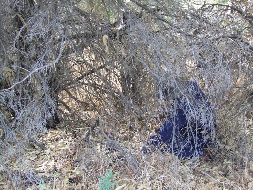
8 (slide 12). This map is a bit the worse for wear after it was taken on site in the pouring rain to mark out the boundaries. The suspected boundaries were marked out on site using tape measures, compass, iron pickets and Earle [Seubert from Friends] as an enthusiastic volunteer risking getting permanently lost in the bush as we tried to establish and measure lines of sight through this: (slide 13 photograph courtesy Earle Seubert).

9 The boundary markers helped give some orientation to the site as we set up a base line and marked out five metres survey squares. This orientation was badly needed as we were not allowed to clear any of the vegetation as the site is within a nature reserve, which created just a few problems marking out neat five metre survey areas. (photograph courtesy Earle Seubert)


10 (photograph courtesy Earle Seubert) Earle just give a short patter on what we are doing if you want such as, throwing the tape through the bush, retrieving it when the catcher missed etc.
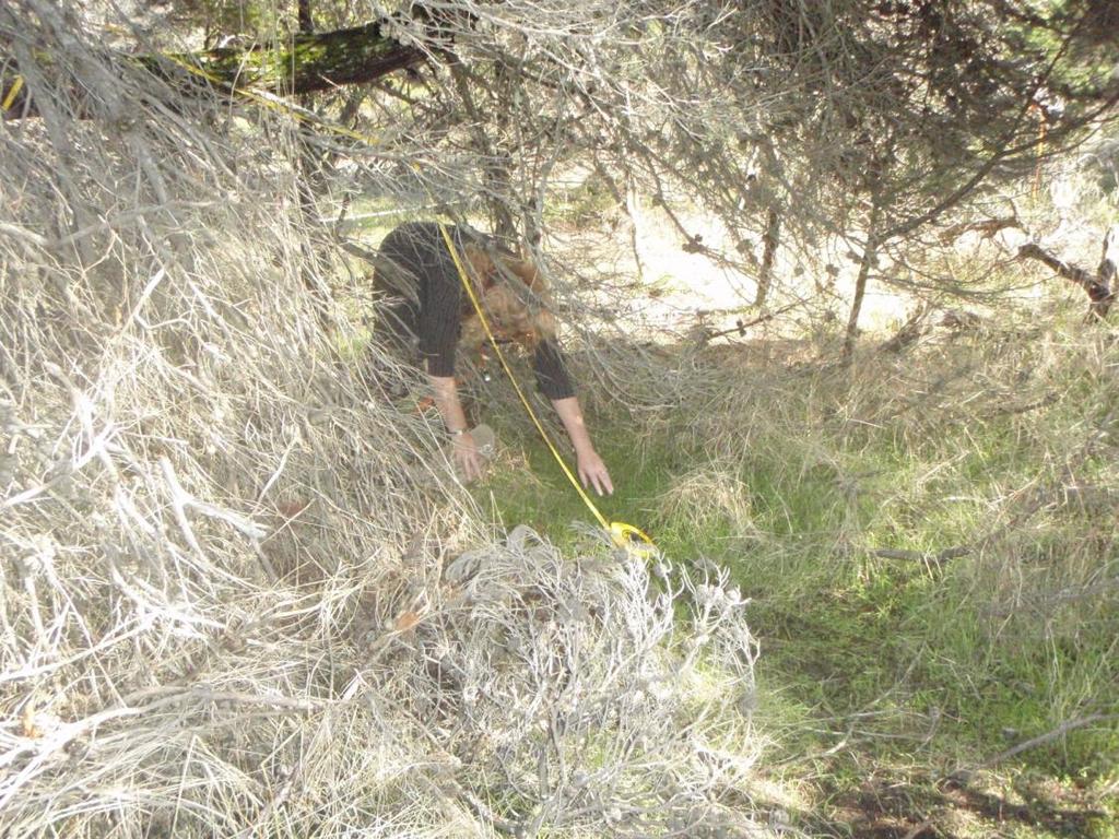
11 (photograph courtesy Earle Seubert)

12 (slides 14 19, photographs courtesy Earle Seubert) The location of unmarked graves was sought in several ways: a detailed site survey in five metre grids to map surface indications of graves such as grave furniture, mounds and depressions, an aerial photographic analysis of the small areas of the site not covered by tree canopy, a metal detector survey of the area to indicate buried evidence, one small test pit to determine what evidence the metal detector was locating, which turned out to be iron rich concrete from a grave, and shovel trenching to locate grave shadows. The shovel trenching was constricted in places by the need not to disturb the roots of Rottnest pines now growing in the cemetery but we did manage to test most of 25 sq metres and located 10 grave shadows before the weather defeated us. With the soil damp from rain the shadows were no longer visible. The finished survey looks like this (Point to the survey poster): with up to 25 unmarked graves identified. Ten of these are firmly located through their grave shadows;
")
13 (slide 20 photograph courtesy Earle Seubert) others are identified through surface findings of smashed grave furniture (slide 21, from grave in square 17, photograph courtesy Earle Seubert)

14 (Slide 22, rose dome from grave 4). photograph courtesy Earle Seubert) Extrapolating up from the historic plans suggested the cemetery was 66 metres long and 39.6 metres wide with an access road jutting from the limestone road into the bottom of the side of the cemetery and the top of the cemetery almost touching the limestone road. We found both the limestone road and the access road, both of which were lost in the bush and no longer used. The access road met our survey grid just after we had run out of surface evidence and were only getting metal detector hits all along a general line. The line of hits were in the location suggested by the historical evidence as the southern boundary fence and almost certainly indicate the location of a picket fence. We know at least part of the cemetery was surrounded by a white picket fence from oral evidence and historic photographs:


15 (slide 23). Both the boundaries in this photograph have been located on site, the southern by metal detector and the western by locating a picket still in situ: (slide 24 photograph courtesy Earle Seubert).
 it is easier to relate the photograph to the part of the survey area in the photograph.")
16 We also located some of the graves shown in these photographs. Some by surface survey, some by aerial analysis and others by finding the graves shadows in the shovel trenches. By retaking the historic photograph from the same spot: (slide 25 photograph courtesy Earle Seubert) it is easier to relate the photograph to the part of the survey area in the photograph. It is clear that graves 1,2,3,5, and 9 were not marked by headstones by the time the photograph was taken, so they are new evidence. Also we found an interesting thing about the grave shadows, which is that some of them are quite small measuring only 1 metre across. This suggests they might be cremation burials or the burials of very small children. Graves 2, 3, 9, and 10 are confirmed to be only small burials. This is the other historic photo of the cemetery

17 (slide 26) showing the area of Nurse Williams grave. Retaking this historic photograph was harder as there is now the trunk of a Rottnest pine tree right where the photographer was standing. However the graves indicated in squares 15, 17, 22, and 58 appear to be in cross locations. However there are more crosses then the evidence we have so far found. The cemetery has more to tell us and if the funding budget permits we will re visit the site next summer to carry on with the trenching. A trenching survey was carried out in 2009, in conjunction with the Earle Seubert, from the Friends of Woodman Point Recreation Camp [Inc].
Peace Hall, Sydney Town Hall Results of Archaeological Program (Interim Report)
") Results of Archaeological Program (Interim Report) Background The proposed excavation of a services basement in the western half of the Peace Hall led to the archaeological investigation of the space in
Results of Archaeological Program (Interim Report) Background The proposed excavation of a services basement in the western half of the Peace Hall led to the archaeological investigation of the space in
THE PRE-CONQUEST COFFINS FROM SWINEGATE AND 18 BACK SWINEGATE
 THE PRE-CONQUEST COFFINS FROM 12 18 SWINEGATE AND 18 BACK SWINEGATE An Insight Report By J.M. McComish York Archaeological Trust for Excavation and Research (2015) Contents 1. INTRODUCTION... 3 2. THE
Chapter 2. Remains. Fig.17 Map of Krang Kor site
 Chapter 2. Remains Section 1. Overview of the Survey Area The survey began in January 2010 by exploring the site of the burial rootings based on information of the rooted burials that was brought to the
December 6, Paul Racher (P007) Archaeological Research Associates Ltd. 900 Guelph St. Kitchener ON N2H 5Z6
 Archaeological Research Associates Ltd. 900 Guelph St. Kitchener ON N2H 5Z6") Ministry of Tourism, Culture and Sport Culture Programs Unit Programs and Services Branch Culture Division 401 Bay Street, Suite 1700 Toronto ON M7A 0A7 Tel.: 416-314-2120 Ministère du Tourisme, de la
Ministry of Tourism, Culture and Sport Culture Programs Unit Programs and Services Branch Culture Division 401 Bay Street, Suite 1700 Toronto ON M7A 0A7 Tel.: 416-314-2120 Ministère du Tourisme, de la
Control ID: Years of experience: Tools used to excavate the grave: Did the participant sieve the fill: Weather conditions: Time taken: Observations:
 Control ID: Control 001 Years of experience: No archaeological experience Tools used to excavate the grave: Trowel, hand shovel and shovel Did the participant sieve the fill: Yes Weather conditions: Flurries
Unearthed tombstones bring spirits of past alive at Langley. Oct. 24, 2006 began with business as usual at Langley, as construction
 Unearthed tombstones bring spirits of past alive at Langley By Laura Baie 1 st Civil Engineer Squadron Oct. 24, 2006 began with business as usual at Langley, as construction activities started bright and
Colchester Archaeological Trust Ltd. A Fieldwalking Survey at Birch, Colchester for ARC Southern Ltd
 Colchester Archaeological Trust Ltd A Fieldwalking Survey at Birch, Colchester for ARC Southern Ltd November 1997 CONTENTS page Summary... 1 Background... 1 Methods... 1 Retrieval Policy... 2 Conditions...
Barnet Battlefield Survey
 In terim report on the progress of the Barnet Battlefield Survey December 2016 The Barnet Battlefield Survey is an archaeological investigation into the 1471 Battle of Barnet. It aims to define more accurately
An archaeological evaluation at 16 Seaview Road, Brightlingsea, Essex February 2004
 An archaeological evaluation at 16 Seaview Road, Brightlingsea, Essex February 2004 report prepared by Kate Orr on behalf of Highfield Homes NGR: TM 086 174 (c) CAT project ref.: 04/2b ECC HAMP group site
ARCHAEOLOGICAL EVALUATION AT BRIGHTON POLYTECHNIC, NORTH FIELD SITE, VARLEY HALLS, COLDEAN LANE, BRIGHTON. by Ian Greig MA AIFA.
 ARCHAEOLOGICAL EVALUATION AT BRIGHTON POLYTECHNIC, NORTH FIELD SITE, VARLEY HALLS, COLDEAN LANE, BRIGHTON by Ian Greig MA AIFA May 1992 South Eastern Archaeological Services Field Archaeology Unit White
The Upper Sabina Tiberina Project: Report for the Archaeological Institute of America Rutgers University Newark
 The Upper Sabina Tiberina Project: Report for the Archaeological Institute of America Rutgers University Newark My archeological dig took place near the village of Vacone, a small town on the outskirts
An archaeological evaluation in the playground of Colchester Royal Grammar School, Lexden Road, Colchester, Essex
 An archaeological evaluation in the playground of Colchester Royal Grammar School, Lexden Road, Colchester, Essex February 2002 on behalf of Roff Marsh Partnership CAT project code: 02/2c Colchester Museum
Weedon Parish Council CHAPEL GRAVEYARD REGULATIONS
 Note These Regulations are in addition to the provision of the Local Authorities Cemeteries Order 1977 and any other appropriate regulations currently in force. 1. General 1.1 The Weedon Chapel Graveyard
Montgomery County Cemeteries
 Name: Darnestown Presbyterian Church Cemetery ID: 76 15120 Turkey Foot Road Darnestown ADC Map: 27 Grid: B-3 Cemetery Association: Presbyterian Condition: Good Negative Impacts: None Burials: 500-1000
Xian Tombs of the Qin Dynasty
 Xian Tombs of the Qin Dynasty By History.com, adapted by Newsela staff In 221 B.C., Qin Shi Huang became emperor of China, and started the Qin Dynasty. At this time, the area had just emerged from over
The Jawan Chamber Tomb Adapted from a report by F.S. Vidal, Dammam, December 1953
 Figure 1 - The Jawan tomb as photographed from helicopter by Sgt. W. Seto, USAF, in May 1952 The Jawan Chamber Tomb Adapted from a report by F.S. Vidal, Dammam, December 1953 I. Description of work and
Grim s Ditch, Starveall Farm, Wootton, Woodstock, Oxfordshire
 Grim s Ditch, Starveall Farm, Wootton, Woodstock, Oxfordshire An Archaeological Recording Action For Empire Homes by Steve Ford Thames Valley Archaeological Services Ltd Site Code SFW06/118 November 2006
Durham, North Carolina
 Durham, North Carolina 27708-0103 Department of Classical Studies Telephone: (919) 681-4292 Box 90103, 233 Allen Building Fax: (919) 681-4262 classics@duke.edu http://www.classicalstudies.duke.edu Cultural
16 members of the Fieldwalking Group met York Community Archaeologist Jon Kenny at Lou Howard s farm, Rose Cottage Farm, at
 Terrington History Group Fieldwalking Group Field 1 Final report 21 October 2011 - fieldwalking 16 members of the Fieldwalking Group met York Community Archaeologist Jon Kenny at Lou Howard s farm, Rose
Archaeological sites and find spots in the parish of Burghclere - SMR no. OS Grid Ref. Site Name Classification Period
 Archaeological sites and find spots in the parish of Burghclere - SMR no. OS Grid Ref. Site Name Classification Period SU45NE 1A SU46880 59200 Ridgemoor Farm Inhumation Burial At Ridgemoor Farm, on the
Moray Archaeology For All Project
 School children learning how to identify finds. (Above) A flint tool found at Clarkly Hill. Copyright: Leanne Demay Moray Archaeology For All Project ational Museums Scotland have been excavating in Moray
An archaeological watching brief and recording at Brightlingsea Quarry, Moverons Lane, Brightlingsea, Essex October 2003
 An archaeological watching brief and recording at Brightlingsea Quarry, Moverons Lane, Brightlingsea, Essex commissioned by Mineral Services Ltd on behalf of Alresford Sand & Ballast Co Ltd report prepared
NGSBA Excavation Reports
 ISSN 2221-9420 NGSBA Excavation Reports Volume 1 (2009) Salvage Excavation at Nahal Saif 2004 Final Report Excavation Permit: B - 293/2004 Excavating Archaeologist: Yehuda Govrin Y. G. Contract Archaeology
A Sense of Place Tor Enclosures
 A Sense of Place Tor Enclosures Tor enclosures were built around six thousand years ago (4000 BC) in the early part of the Neolithic period. They are large enclosures defined by stony banks sited on hilltops
Is this the Original Anglo-Saxon period site of Weathercote?
 Is this the Original Anglo-Saxon period site of Weathercote? A Batty & N Crack 2016 Front Cover. Looking south east across proposed original site of Weathercote. Photograph A 2 3 Weathercote Anglo-Saxon
Remains of four early colonial leaders discovered at Jamestown 28 July 2015, bybrett Zongker
 Remains of four early colonial leaders discovered at Jamestown 28 July 2015, bybrett Zongker William "Bill" Kelso, Director of Research and Interpretation for the Preservation Virginia Jamestown Rediscovery,
Weetwood Moor. What are cup & ring marks?
 Weetwood Moor On this small stretch of moorland you can find some of the most recognisable ancient cup and ring marked stones in the UK. There are three interesting spots we d like to share with you. What
BALNUARAN. of C LAVA. a prehistoric cemetery. A Visitors Guide to
 A Visitors Guide to BALNUARAN of C LAVA a prehistoric cemetery Milton of Clava Chapel (?) Cairn River Nairn Balnuaran of Clava is the site of an exceptionally wellpreserved group of prehistoric burial
HOLY CROSS CEMETERY PRICING INFORMATION Effective July 1, 2017
 HOLY CROSS CEMETERY PRICING INFORMATION Effective July 1, 2017 PARISH MEMBER PRICING Traditional Casket/Vault Grave $600.00 Cremation Plot (up to four cremated remains, foundation included) $700.00 Columbarium
Information for Teachers
 Sueno s Stone in Forres is the tallest carved stone in Scotland and shows a dramatic battle scene. Investigating Sueno s Stone Information for Teachers education investigating historic sites 2 Sueno s
January 13 th, 2019 Sample Current Affairs
 January 13 th, 2019 Sample Current Affairs 1. Harappa grave of ancient 'couple' reveals secrets of Marriage What are the key takeaways of the excavation? Was marriage legally accepted in Harappan society?
THE RAVENSTONE BEAKER
 DISCOVERY THE RAVENSTONE BEAKER K. J. FIELD The discovery of the Ravenstone Beaker (Plate Xa Fig. 1) was made by members of the Wolverton and District Archaeological Society engaged on a routine field
An archaeological watching brief at St Leonard s church, Hythe Hill, Colchester, Essex
 An archaeological watching brief at St Leonard s church, Hythe Hill, Colchester, Essex report prepared by Adam Wightman on behalf of Dorvell Construction CAT project ref.: 10/5d Colchester and Ipswich
New Composting Centre, Ashgrove Farm, Ardley, Oxfordshire
 New Composting Centre, Ashgrove Farm, Ardley, Oxfordshire An Archaeological Watching Brief For Agrivert Limited by Andrew Weale Thames Valley Archaeological Services Ltd Site Code AFA 09/20 August 2009
Inadvertent Discovery Plan (IDP)
") Inadvertent Discovery Plan (IDP) Permit Number: Project Name: Applicant: Property Address: As the project proponent, I have read this document in full and understand that: 1. I will follow the actions
Inadvertent Discovery Plan (IDP) Permit Number: Project Name: Applicant: Property Address: As the project proponent, I have read this document in full and understand that: 1. I will follow the actions
The National Board of Antiquities guidelines and instructions 13. Antiquities, ancient monuments and metal detectors: an enthusiast s guide
 The National Board of Antiquities guidelines and instructions 13 Antiquities, ancient monuments and metal detectors: an enthusiast s guide ANTIQUITIES, ANCIENT MONUMENTS AND METAL DETECTORS: AN ENTHUSIAST
Each year, metal detecting results in many archaeological finds which are important for research, dissemination and management.
 GUIDELINES FOR THE Private Use of Metal Detectors The Directorate for Cultural Heritage is a government agency under the Ministry of Climate and Environment, and plays an advisory role in the development
1 The East Oxford Archaeology and History Project
 1 The East Oxford Archaeology and History Project EXOP TEST PIT 72 Location: Bartlemas Chapel, Cowley Date of excavation: 6-8 November 2013. Area of excavation: 0.8m x 1.2m, at the eastern end of the chapel.
Archaeological. Monitoring & Recording Report. Fulbourn Primary School, Cambridgeshire. Archaeological Monitoring & Recording Report.
 Fulbourn Primary School, Cambridgeshire Archaeological Monitoring & Recording Report October 2014 Client: Cambridgeshire County Council OA East Report No: 1689 OASIS No: oxfordar3-192890 NGR: TL 5190 5613
The VIKING DEAD. Discovering the North Men. A brand new 6 part series Written and directed by Jeremy Freeston (Medieval Dead Seasons 1-3)
") The VIKING DEAD Discovering the North Men A brand new 6 part series Written and directed by Jeremy Freeston (Medieval Dead Seasons 1-3) With lead contributor Tim Sutherland (Medieval Dead Seasons 1-3)
The VIKING DEAD Discovering the North Men A brand new 6 part series Written and directed by Jeremy Freeston (Medieval Dead Seasons 1-3) With lead contributor Tim Sutherland (Medieval Dead Seasons 1-3)
Burrell Orchard 2014: Cleveland Archaeological Society Internship Amanda Ponomarenko The Ohio State University June - August 2014
 1 Burrell Orchard 2014: Cleveland Archaeological Society Internship Amanda Ponomarenko The Ohio State University June - August 2014 Selected for the 2014 Cleveland Archaeological Society Internship in
ST PATRICK S CHAPEL, ST DAVIDS PEMBROKESHIRE 2015
 ST PATRICK S CHAPEL, ST DAVIDS PEMBROKESHIRE 2015 REPORT FOR THE NINEVEH CHARITABLE TRUST THE UNIVERSITY OF SHEFFIELD AND DYFED ARCHAEOLOGICAL TRUST Introduction ST PATRICK S CHAPEL, ST DAVIDS, PEMBROKESHIRE,
Jane C. Waldbaum Archaeology Field School Scholarship. It was difficult at first to adjust to the ten-hour time change, but my body quickly
 Hart 1 American Institute of Archaeology Field School Report Jane C. Waldbaum Archaeology Field School Scholarship Ashlee Hart 8 August 2013 The day began with roosters crowing and an alarm clock pounding
Greater London GREATER LONDON 3/606 (E ) TQ
 TQ") GREATER LONDON City of London 3/606 (E.01.6024) TQ 30358150 1 PLOUGH PLACE, CITY OF LONDON An Archaeological Watching Brief at 1 Plough Place, City of London, London EC4 Butler, J London : Pre-Construct
GREATER LONDON City of London 3/606 (E.01.6024) TQ 30358150 1 PLOUGH PLACE, CITY OF LONDON An Archaeological Watching Brief at 1 Plough Place, City of London, London EC4 Butler, J London : Pre-Construct
An archaeological evaluation at the Lexden Wood Golf Club (Westhouse Farm), Lexden, Colchester, Essex
, Lexden, Colchester, Essex") An archaeological evaluation at the Lexden Wood Golf Club (Westhouse Farm), Lexden, Colchester, Essex January 2000 Archive report on behalf of Lexden Wood Golf Club Colchester Archaeological Trust 12 Lexden
An archaeological evaluation at the Lexden Wood Golf Club (Westhouse Farm), Lexden, Colchester, Essex January 2000 Archive report on behalf of Lexden Wood Golf Club Colchester Archaeological Trust 12 Lexden
Advanced archaeology at the archive. Museum of London Support materials AS/A2 study day
 Advanced archaeology at the archive Support materials AS/A2 study day Contents National Curriculum links and session description 1-2 Example timetable 3 Practical guidelines 4 Visit preparation and pre-visit
The Living and the Dead
 The Living and the Dead Round Barrows and cairns The transition from the late Neolithic to the early Bronze Age is traditionally associated with an influx of immigrants to the British Isles from continental
LARKHILL MARRIED QUARTERS ARCHAEOLOGY OF THE FIRST WORLD WAR BY MARK KHAN
 LARKHILL MARRIED QUARTERS ARCHAEOLOGY OF THE FIRST WORLD WAR BY MARK KHAN As many people may have seen recently on television the Army Basing Project responsible for the construction of new service accommodation
Land North of Pesthouse Lane Barham Suffolk BRH 054
 Land North of Pesthouse Lane Barham Suffolk BRH 054 Archaeological Evaluation Report SCCAS Report No. 2012/142 Client: Barham Parish Council Author: Jezz Meredith September 2012 SCCAS Land North of Pesthouse
7. Prehistoric features and an early medieval enclosure at Coonagh West, Co. Limerick Kate Taylor
 7. Prehistoric features and an early medieval enclosure at Coonagh West, Co. Limerick Kate Taylor Illus. 1 Location of the site in Coonagh West, Co. Limerick (based on the Ordnance Survey Ireland map)
Fieldwalking at Cottam 1994 (COT94F)
") Fieldwalking at Cottam 1994 (COT94F) Tony Austin & Elizabeth Jelley (19 Jan 29) 1. Introduction During the winter of 1994 students from the Department of Archaeology at the University of York undertook
Fieldwalking at Cottam 1994 (COT94F) Tony Austin & Elizabeth Jelley (19 Jan 29) 1. Introduction During the winter of 1994 students from the Department of Archaeology at the University of York undertook
Hauger, Haller, Hav The permanent exhibition of the Midgard Viking Center in Borre, Norway
 Hauger, Haller, Hav The permanent exhibition of the Midgard Viking Center in Borre, Norway Vestfold hosts some of the most famous Viking Age sites like the well-known ship burials at Oseberg and Gokstad.
Monitoring Report No. 99
 Monitoring Report No. 99 Enniskillen Castle Co. Fermanagh AE/06/23 Cormac McSparron Site Specific Information Site Name: Townland: Enniskillen Castle Enniskillen SMR No: FER 211:039 Grid Ref: County: Excavation
Memorials. Fact sheets Taking a closer look at.
 Fact sheets Taking a closer look at. Memorials It is suggested that one or two the following fact sheets are printed out and used as wall or poster displays or laminate and make available for students
Evidence for the use of bronze mining tools in the Bronze Age copper mines on the Great Orme, Llandudno
 Evidence for the use of bronze mining tools in the Bronze Age copper mines on the Great Orme, Llandudno Background The possible use of bronze mining tools has been widely debated since the discovery of
Censer Symbolism and the State Polity in Teotihuacán
 FAMSI 2002: Saburo Sugiyama Censer Symbolism and the State Polity in Teotihuacán Research Year: 1998 Culture: Teotihuacán Chronology: Late Pre-Classic to Late Classic Location: Highland México Site: Teotihuacán
LE CATILLON II HOARD. jerseyheritage.org Association of Jersey Charities, No. 161
 LE CATILLON II HOARD CELTIC TRIBES This is a picture of the tribal structure of the Celtic Society CELTIC TRIBES Can you see three different people in the picture and suggest what they do? Can you describe
Bristol & Gloucestershire Archaeological Society
 Chris Hayden, Rob Early, Edward Biddulph, Paul Booth, Anne Dodd, Alex Smith, Granville Laws and Ken Welsh, Horcott Quarry, Fairford and Arkell's Land, Kempsford: Prehistoric, Roman and Anglo-Saxon settlement
Teachers Pack
 Whitehorse Hill: A Prehistoric Dartmoor Discovery 13.09.14-13.12.14 Teachers Pack CONTENTS About the Teachers Pack 05 Introduction to the exhibition 05 Prehistoric Britain - Timeline 05 What changed? Technology,
Former Whitbread Training Centre Site, Abbey Street, Faversham, Kent Interim Archaeological Report Phase 1 November 2009
 Former Whitbread Training Centre Site, Abbey Street, Faversham, Kent Interim Archaeological Report Phase 1 November 2009 SWAT. Archaeology Swale and Thames Archaeological Survey Company School Farm Oast,
Education Pack for Junior Certificate History
 Education Pack for Junior Certificate History Introduction This education pack has been designed by the Brú na Bóinne guides as an aid for teachers and pupils of the Junior Certificate History syllabus.
POWYS - churchyard sites with younger yews
 CPAT refers to the Clwyd/Powys Archaeological Trust POWYS - churchyard sites with younger yews BEGUILDY St Michael SO194797 25/4/2004 Tim Hills In 1995 CPAT noted a line of 3 yews west of the church, only
MARSTON MICHAEL FARLEY
 MARSTON MICHAEL FARLEY On 9 March agricultural contractors, laying field drains for Bucks County Council Land Agent's Department, cut through a limestone structure at SP 75852301 in an area otherwise consistently
Amarna South Tombs Cemetery The 2011 Excavations at the Lower Site and Wadi Mouth Site Preliminary Archaeological Report
 Amarna South Tombs Cemetery The 2011 Excavations at the Lower Site and Wadi Mouth Site Preliminary Archaeological Report A. Stevens July 2012 1 The 2011 season of excavations at the South Tombs Cemetery
Oxfordshire. Wallingford. St Mary-le-More. Archaeological Watching Brief Report. Client: JBKS Architects and St Mary s Renewal Campaign.
 St Mary-le-More Wallingford Oxfordshire Archaeological Watching Brief Report February 2010 Client: JBKS Architects and St Mary s Renewal Campaign Issue No:1 OA Job No: 4432 NGR: SU 6071 8933 Archaeological
3. The new face of Bronze Age pottery Jacinta Kiely and Bruce Sutton
 3. The new face of Bronze Age pottery Jacinta Kiely and Bruce Sutton Illus. 1 Location map of Early Bronze Age site at Mitchelstown, Co. Cork (based on the Ordnance Survey Ireland map) A previously unknown
FAST & LIGHT MK2 Instruction Guide
 WWW.AQUAPRODUCTS.CO.UK FAST & LIGHT MK2 Instruction Guide FAST & LIGHT MK2 Specification Groundbreaking, innovative & ultra compact. Fast & Light MK2 Performance grade AQUATEXX Space saver frame. Ninth
The lithic assemblage from Kingsdale Head (KH09)
") 1 The lithic assemblage from Kingsdale Head (KH09) Hannah Russ Introduction During excavation the of potential Mesolithic features at Kingsdale Head in 2009 an assemblage of flint and chert artefacts were
1 The lithic assemblage from Kingsdale Head (KH09) Hannah Russ Introduction During excavation the of potential Mesolithic features at Kingsdale Head in 2009 an assemblage of flint and chert artefacts were
Limited Archaeological Testing at the Sands House Annapolis, Maryland
 Limited Archaeological Testing at the Sands House Annapolis, Maryland Report Submitted to Four Rivers Heritage Area by John E. Kille, Ph.D., Shawn Sharpe, and Al Luckenbach, Ph.D February 10, 2012 In May-June
Archaeological Material From Spa Ghyll Farm, Aldfield
 Archaeological Material From Spa Ghyll Farm, Aldfield Introduction Following discussions with Linda Smith the Rural Archaeologist for North Yorkshire County Council, Robert Morgan of 3D Archaeological
DEMARCATION OF THE STONE AGES.
 20 HAMPSHIRE FLINTS. DEMARCATION OF THE STONE AGES. BY W, DALE, F.S.A., F.G.S. (Read before the Anthropological Section of -the British Association for the advancement of Science, at Birmingham, September
TIPPERARY HISTORICAL JOURNAL 1994
 TPPERARY HSTORCAL JOURNAL 1994 County Tipperary Historical Society www.tipperarylibraries.ie/ths society@tipperarylibraries. ie SSN 0791-0655 Excavations at Cormac's Chapel, Cashel, 1992 and 1993: a preliminary
EVALUATION REPORT No. 273
 EVALUATION REPORT No. 273 Freeduff Presbyterian Church, 3 Oldtown road, Freeduff, Cullyhanna, County Armagh Licence No.: AE/13/133E Sapphire Mussen Report Date: 20/09/2013 Contents List of Figures... 2
Difference between Architecture and Sculpture. Architecture refers to the design and construction of buildings
 Art and Culture 1.1 Introduction Difference between Architecture and Sculpture Classification of Indian Architecture Indus Valley Civilization and their archaeological findings BY CIVIL JOINT The Word
Anglo-Saxons. Gallery Activities
 A Anglo-Saxons Gallery Activities Learning & Information Department Telephone +44 (0)20 7323 8511/8854 Facsimile +44 (0)20 7323 8855 education@thebritishmuseum.ac.uk Great Russell Street London WC1B 3DG
Montgomery County Cemeteries
 Name: Warren United Methodist Church Cemetery ID: 151 Warren Meth. Epis. Church, Warren's Chapel 19100 block of Martinsburg Road Martinsburg ADC Map: 15 Grid: D-3 Cemetery Association: Free Black, Methodist
Warstone Lane catacombs
 Warstone Lane catacombs Recently, Shortie and Leslam investigated the Warstone Burial indices to try to identify certain grave numbers that do not appear on the grave plans. This was instigated by the
FURTHER MIDDLE SAXON EVIDENCE AT COOK STREET, SOUTHAMPTON (SOU 567)
") Roc. Hampshire Field Club Archaeol. Soc 52,1997, 77-87 (Hampshire Studies 1997) FURTHER MIDDLE SAXON EVIDENCE AT COOK STREET, SOUTHAMPTON (SOU 567) By M F GARNER andj VINCENT with a contribution byjacqueline
Roc. Hampshire Field Club Archaeol. Soc 52,1997, 77-87 (Hampshire Studies 1997) FURTHER MIDDLE SAXON EVIDENCE AT COOK STREET, SOUTHAMPTON (SOU 567) By M F GARNER andj VINCENT with a contribution byjacqueline
To foster a city with strong social cohesion, an engaging arts scene, and a clear sense of its culture and heritage.
 HERITAGE VAUGHAN COMMITTEE MARCH 20, 2013 8222-8248 KIPLING AVENUE HERITAGE REVIEW OF PROPOSED NEW TOWNHOMES, NEW SINGLE FAMILY HOME, TWO SEMI-DETACHED HOMES AND DEMOLITION OF EXISTING STRUCTURES AT 8222
<Plate 4 here, in b/w> Two Cahokia s Coles Creek Predecessors Vincas P. Steponaitis, Megan C. Kassabaum, and John W. O Hear
 [To be published in Medieval Mississippians: The Cahokian World, edited by Susan M. Alt and Timothy R. Pauketat, SAR Press, Santa Fe. Draft of November 20, 2013.] Two Cahokia s Coles
2010 Watson Surface Collection
 2010 Watson Surface Collection Carol Cowherd Charles County Archaeological Society of Maryland, Inc. Chapter of Archeological Society of Maryland, Inc. November 2010 2011 Charles County Archaeological
Bronze Age 2, BC
 Bronze Age 2,000-600 BC There may be continuity with the Neolithic period in the Early Bronze Age, with the harbour being used for seasonal grazing, and perhaps butchering and hide preparation. In the
Medieval Burials and the Black Death
 Medieval Burials and the Black Death A Report on Badia Pozzeveri, Italy Bioarchaeology Field School Summer 2015 During the summer of 2015, I was given the opportunity to participate in the Ohio State University/Universitá
STONE implements and pottery indicative of Late Neolithic settlement are known to
 Late Neolithic Site in the Extreme Northwest of the New Territories, Hong Kong Received 29 July 1966 T. N. CHIU* AND M. K. WOO** THE SITE STONE implements and pottery indicative of Late Neolithic settlement
Forteviot, Perthshire: Excavations at the Entrance Avenue of the Neolithic Palisaded Enclosure Interim Report and Data Structure Report
 Forteviot, Perthshire: Excavations at the Entrance Avenue of the Neolithic Palisaded Enclosure 2007 Interim Report and Data Structure Report by Gordon Noble and Kenneth Brophy Table of Contents Summary
Cambridge Archaeology Field Group. Fieldwalking on the Childerley Estate, Cambridgeshire. Autumn 2014 to Spring Third interim report
 Cambridge Archaeology Field Group Fieldwalking on the Childerley Estate, Cambridgeshire Autumn 2014 to Spring 2015 Third interim report Summary Field walking on the Childerley estate of Martin Jenkins
Test Valley. Test Valley. CREMATORIUM
 Test Valley CREMATORIUM Shootash A3057 A3090 A27 Romsey Botley Road Woodington Ryedown Lane A3090 A27 A27 Whinwhistle Rd Blackhill A36 Gardeners Lane Wigley Romsey Road Test Valley CREMATORIUM Ridge Lane
Chapel House Wood Landscape Project. Interim Report 2013
 Chapel House Wood Landscape Project Interim Report 2013 Chapel House Wood Landscape Project Interim Report 2013 The annual Dales Heritage Field School was held at Chapel House Wood again this year, and
Resource for Teachers
 Resource for Teachers Understanding verbs used in P/M/D grade descriptors AM20530 Level 2 Certificate in Hairdressing and Beauty Therapy (VRQ) Resource for Teachers AM20530 - Level 2 Certificate in Hairdressing
ALUTIIQ MUSEUM & ARCHAEOLOGICAL REPOSITORY 215 Mission Road, Suite 101! Kodiak, Alaska 99615! ! FAX EXHIBITS POLICY
 ALUTIIQ MUSEUM & ARCHAEOLOGICAL REPOSITORY 215 Mission Road, Suite 101! Kodiak, Alaska 99615! 907-486-7004! FAX 907-486-7048 EXHIBITS POLICY I. INTRODUCTION The Alutiiq Heritage Foundation recognizes that
The Papar Project Hebrides
 The Papar Project Hebrides Barbara E. Crawford and Ian Simpson H1. Pabay/Pabaigh (Uig, Lewis) Parish History H2. Pabbay/Pabaigh (Harris) Ecclesiastical Monuments Other Archaeological Sites Fieldwork 2005
Amanda K. Chen Department of Art History and Archaeology University of Maryland, College Park
 Amanda K. Chen Department of Art History and Archaeology University of Maryland, College Park Jane C. Waldbaum Archaeological Field School Scholarship Field Report: The Coriglia/Orvieto Project With great
FINDING LIFE FROM GRAVE GOODS
 FINDING LIFE FROM GRAVE GOODS Summary: In archaeology classes it appears that students are often told what the correct answer is, rather than being forced to make inferences themselves based upon archaeological
A visit to the Wor Barrow 21 st November 2015
 A visit to the Wor Barrow 21 st November 2015 Following our exploration of Winkelbury a few weeks previously, we fast forwarded 12 years in Pitt Rivers remarkable series of excavations and followed him
17 Phase 5. High and Late medieval features and activities AD
 17 Phase 5. High and Late medieval features and activities 1200 1550 AD 17.1 Results This time phase is based on all findings that can be placed in the High and Late medieval period 1200 1550 AD based
Contact for further information about this collection Abstract
 Brauner, Henry RG-50.029*0008 One Video Tape In English Abstract Henry Brauner was born in Krakow, Poland, on May 24, 1921. Two years later his family moved to Breslau, Germany. They lived in an Orthodox
Greater London Region GREATER LONDON 3/567 (E.01.K099) TQ BERMONDSEY STREET AND GIFCO BUILDING AND CAR PARK
 TQ BERMONDSEY STREET AND GIFCO BUILDING AND CAR PARK") GREATER LONDON 3/567 (E.01.K099) TQ 33307955 156-170 BERMONDSEY STREET AND GIFCO BUILDING AND CAR PARK Assessment of an Archaeological Excavation at 156-170 Bermondsey Street and GIFCO Building and Car
GREATER LONDON 3/567 (E.01.K099) TQ 33307955 156-170 BERMONDSEY STREET AND GIFCO BUILDING AND CAR PARK Assessment of an Archaeological Excavation at 156-170 Bermondsey Street and GIFCO Building and Car
Presentation Objectives
 THE ECONOMICS OF AN ANTI-AGEING PRACTICE PLASTIC SURGERY ASSOCIATES UK BUPA CROMWELL HOSPITAL LONDON CONSTANCE CAMPION Nurse Practitioner Analyst Private Medical Equity THE LONDON WELLNESS CENTRE 90 ½
Cullity Gallery Hire Information
 Cullity Gallery Hire Information Background The Cullity Gallery at The University of Western Australia is an exhibition space on the ground floor of the Architecture, Landscape and Visual Arts building,
An archaeological evaluation at the Blackwater Hotel, Church Road, West Mersea, Colchester, Essex March 2003
 An archaeological evaluation at the Blackwater Hotel, Church Road, West Mersea, Colchester, Essex report prepared by Laura Pooley on behalf of Dolphin Developments (U.K) Ltd NGR: TM 0082 1259 CAT project