The Llandeilo Roman Forts: Archaeological Investigations
|
|
|
- Joshua Stevens
- 6 years ago
- Views:
Transcription


1 The Llandeilo Roman Forts: Archaeological Investigations Paratowyd gan Archaeoleg Cambria Ar gyfer Yr Ymddiriedolaeth Genedlaethol Prepared by Cambria Archaeology For the National Trust

2 ARCHAEOLEG CAMBRIA ARCHAEOLOGY RHIF YR ADRODDIAD / REPORT NO. 2006/38 RHIF Y PROSIECT / PROJECT RECORD NO Rhagfyr 2007 December 2007 The Llandeilo Roman Forts: Archaeological Investigations Gan / By GWILYM HUGHES Archaeoleg Cambria yw enw marchnata Ymddiriedolaeth Archaeolegol Dyfed Cyfyngedig. Cambria Archaeology is the marketing name of the Dyfed Archaeological Trust Limited. ARCHAEOLEG CAMBRIA Ymddiriedolaeth Archaeolegol Dyfed Cyf Neuadd y Sir, Stryd Caerfyrddin, Llandeilo, Sir Gaerfyrddin SA19 6AF Ffon: Ymholiadau Cyffredinol Adran Rheoli Treftadaeth Ffacs: Ebost: cambria@cambria.org.uk Gwefan: CAMBRIA ARCHAEOLOGY Dyfed Archaeological Trust Limited The Shire Hall, Carmarthen Street, Llandeilo, Carmarthenshire SA19 6AF Tel: General Enquiries Heritage Management Section Fax: cambria@cambria.org.uk Website: Cwmni cyfyngedig ( ) ynghyd ag elusen gofrestredig (504616) yw r Ymddiriedolaeth. The Trust is both a Limited Company (No ) and a Registered Charity (No ) CADEIRYDD CHAIRMAN: C R MUSSON MBE B Arch FSA MIFA. CYFARWYDDWR DIRECTOR: E G HUGHES BA FSA MIFA page 2
3 The Llandeilo Roman Forts: Archaeological Investigations, INTRODUCTION This report describes the results of an archaeological investigation, including geophysical survey and excavation, undertaken on two recently discovered Roman Forts in Dinefwr Park, Llandeilo (Fig. 1, SN ). The archaeological work formed part of a wider project being undertaken by the National Trust with the aim of restoring the designed landscape, enhancing the natural environment and facilitating access to all. This project was funded by the Heritage Lottery Fund and the Wales European Funding Office. The National Trust intended to restore many of the features of the designed landscape, and this was to include the removal of some field boundaries and tree clumps and the establishment of others. Before this could be achieved there was a need to provide more and better information on the character and survival of the archaeological deposits in this area of the Park. This was the principal objective of the archaeological investigation. The investigation also had the potential for addressing a number of research objectives several of which had been highlighted during the production of a research framework for the archaeology of Wales ( These are outlined in more detail below. From the beginning there was also an intention to ensure that opportunities would be provided for schoolchildren and members of the public to be closely involved in the project. The geophysical survey was undertaken in two stages by Stratascan, in February and March 2003 and between May and July The first phase demonstrated the presence of two superimposed Roman forts, associated roads and vicus and a possible bathhouse in the eastern part of Dinefwr Park (Stratascan 2003;Hughes 2003). The initial geophysical survey also suggested a high degree of preservation of the archaeological deposits. The second phase extended the survey to include the whole of the area of the larger of the two forts and to clarify the extent of the archaeology in the area of the vicus and the possible bathhouse (Heard 2005). The main phase of the excavation was undertaken by Cambria Archaeology over a period of three weeks in June and July 2005 and this phase of the work was accompanied by a major programme of public outreach and involvement. Two smaller pieces of fieldwork were undertaken in July 2006 and March For ease of reference the larger of the two forts is referred to as Fort 1 in this report and the smaller fort is referred to as Fort 2. ARCHAEOLOGICAL BACKGROUND Note the PRN numbers refer to the Primary Record Numbers on the regional Sites and Monuments Record held and maintained by Cambria Archaeology). Prior to the 1990s the evidence for Roman activity within the area of Dinefwr Park was fragmentary. A milestone (PRN 972) bearing an inscription to the Emperor Tacitus (AD ) was recorded in 1697 apparently built into a farmhouse near Dinefwr although this object is now lost (Jarret 1969, 186). However, it may have been brought to the site from its original findspot. There are also antiquarian records of a possible Roman structure below Llandyfeisant church (PRN 7367) and this is also marked on the early editions of the OS maps. A number of Roman coins have been found from the Llandeilo area including a possible mid-late 3 rd century coin hoard (PRN 886), a possible late 1 st century coin hoard (PRN 869) and an as of Tiberius (AD10) found before 1920 at the junction of Alan and page 3
4 Latimer Roads (PRN 875). In addition the head of a female pottery figurine (now lost) was recorded near to Llandeilo Bridge (PRN 874). During the early 1980s aerial survey and fieldwork identified clear stretches of the Roman road running between Llandovery and Carmarthen (James and James 1984). One stretch was identified to the northeast of Cwmifor in the area of Down Farm. It is thought that this stretch of road then continues in a southwesterly direction and may underlie the course of the current A40 as it approaches Rhosmaen. Stretches of the road have also been identified to the west of Llandeilo between Broadoak and Llanegwad. Given the midway location of Llandeilo between Carmarthen and Llandovery it was considered the obvious place for a Roman fort that were frequently spaced a day s march apart (James 2000, 30-31). Finds of Roman pottery were subsequently recovered during a brief walkover survey in 1993 from two areas immediately to the south of Home Farm (PRN and and Crane 1994, 2 and 6). Several fragments of pottery including samian ware were recovered from the northwest corner of Brick Field (PRN 47646) and further fragments (PRN 47647), including part of amphorae handle, were recovered from the spoil created by a recently excavated pond in the field to the south of the Cae William rugby ground. The character of this material was considered to be entirely consistent with a military establishment or high status settlement dating to the late 1 st early 2 nd century AD (see page 14 below). A small-scale geophysical survey was undertaken in the areas where this material was found. Although this survey was inconclusive, the results were based on a very small sample area. Finds of Romano-British pottery have also been identified in a streambed at the western end of the landscaped park just inside the western boundary (PRN see page 14 below). All this evidence prompted Heather James in 1993 to tentatively suggest the layout and location of the Roman fort immediately to the south of Home Farm. This was intended to inform the planning process relating to proposals that had been put forward at that time for a proposed golf course. The results of the current geophysical survey demonstrate that her prediction was extraordinarily accurate. In 2000, a number of coins, including seven silver denerii (PRN 47648), found by a metal detectorist in the area of Home Farm were reported to the Carmarthenshire County Museum under the Portable Antiquities Scheme (and identified by Edward Besley of the National Museums and Galleries of Wales). They include three Republican coins (c 100BC to c 31BC), one coin dating to the reign of Augustus (27 BC to AD14) and three late 1st century AD coins (AD69- AD96). The opportunity to investigate the area of Home Farm was provided early in 2003 when the National Trust bought the Farm and associated fields with the assistance of a grant from the Heritage Lottery Fund. Soon after the purchase of this land, the National Trust commissioned Cambria Archaeology to undertake a wide-ranging archaeological survey that was intended to inform the developing conservation plan for the whole of the estate. This included both topographic survey in the area of the Deer Park (Murphy 2003) and geophysical survey. The principal focus of the geophysical survey, undertaken by Stratascan, was the large block of land (c. 27 hectares) to the south of Home Farm. page 4
5 THE GEOPHYSICAL SURVEY Methodology An initial reconnaissance survey using magnetic susceptibility was undertaken across the whole of the area (Stratascan 2003, 5). The intention was to use these results to identify areas of potential that would be targeted with more detailed magnetometer survey. A total of hectares were surveyed using magnetometry in two stages. Both phases collected readings at 0.25m centres along transects 1m apart using dual FM256 Fluxgate Gradiometers. The data was processed using Geoplot 3 and the combined results are illustrated in Figure 2. A detailed review of the methodology of the survey is provided in the Stratascan reports (Stratascan 2003 and Heard 2005). The following text is a narrative of the combined results of the two phases of geophysical survey. Results Fort 1 The first phase of the survey identified the eastern corner of the multivallate defences of Fort 1, although this interpretation was not finally confirmed until the second phase of the survey had been carried. The initial survey suggested that the defences comprised at least three and possibly four ditches and associated ramparts. A four-post structure, probably an interval tower, was located on the line of the inner rampart of the northeast defences close to the eastern corner. The second phase of the survey identified the southern and western extent of this fort. Three defensive ditches run along the southeastern side of the fort and two along the southwestern side. Gateways can be identified in both of these sides. A third possible defensive ditch on the southwest side lies approximately 55m to the southwest. The internal dimensions (ie the area lying within the inner ditches) are 240m x 160m (3.84 hectares). The orientation and internal layout of Fort 1 cannot be determined with any certainty from the geophysical survey results alone. It seems probable that the front of the fort (the praetentura) is located to the northeast. This is certainly the case with Fort 2 (see below). A group of anomalies within the eastern corner of the fort suggest the presence of several substantial buildings apparently of at least two phases. These structures either relate to the internal arrangements of Fort 1 or to a development external to Fort 2. It is possible that part of the northern and eastern defences of Fort 1 continued to be used as an annex to Fort 2 and provided some protection for these structures. A large thermoremnant response was detected on the inner line of the southeast defences. This was interpreted by Stratascan as a possible kiln or large hearth (Stratascan 2003, 11). The location of such a feature, dug into the rear of the inner rampart, would seem to be logical with the intervallum road acting as a windbreak. A further line of larger positive anomalies appear to coincide with the rear of the inner rampart associated with the southwest line of defences. Lines of pit-like anomalies in the southern corner of Fort 1 suggest the structural remains (possibly post-holes) of a rectangular building or buildings. Fort 2 The alignment and internal arrangement of Fort 2 is much clearer and it has overall internal dimensions of c 140m x 110m (1.54 hectares). Although only the southern corner of the defences was fully covered by the survey, elements of all four sides were recorded and three of the four entrances can be clearly identified. The southeastern line of the defences appears to be represented by at least three page 5
6 ditches. The outer two ditches appear to be joined at the entrance on this side (the porta principalis dextra). This defensive arrangement, referred to as a parrot s beak system has been linked with the legio II Adiutrix who were based in Chester. However, the apparent presence of this feature at Llandeilo and elsewhere must now call this association into question (Jeff Davies pers. comm.). There appears to be a slightly wider berm between the second and third ditches on the southeastern side, especially noticeable to the northeast of the entrance. The composition of the northeastern and northwestern defences is not as clearly defined although the entrances (the porta praetoria and the porta principalis sinistra) can be clearly identified. There does not appear to be any break in the outer defences on the southwest side of the fort in the area where the rear entrance (the porta decumana) might be expected. However, a break is apparent in the inner ditch on this side of the fort. Possibly the outer ditches were crossed by a bridge. Topographically the layout of the fort appears to follow conventional lines. The assumed location of the porta decumana corresponds with the highest point of the fort and a second slightly lower knoll corresponds with the location of the porta praetoria. The remaining area of the fort is laid out on more level ground along the top of a low ridge. There are excellent sight lines to the west down the Twyi valley towards Carmarthen and to the northeast up the Twyi valley towards Llandovery. The view to the southwest is dominated by the hill on which the later medieval castle stands. The view to the southeast is more restricted by the proximity of Penlan Fawr. Part of the internal layout of roads can be confidently identified, in particular the via principalis and the front part of the via praetoria. Elements of the intervallum road (the via sagularis) can be identified and this presumably continued around the remaining internal perimeter of the fort. A second transverse road can just about be identified (possibly the via quintana). Numerous rectilinear features have been picked out by the detailed geophysical interpretation (Stratascan 2003, Figure 18). It is suggested that some of the stronger positive anomalies might be indicative of structures built with material having thermoremnant properties such as fired clay and brick (Stratascan 2003, 11). Clearly this would need to be tested by excavation. It is possible to predict the location of certain buildings. In particular the headquarters building (the principia) is likely to be located near to the centre of the fort between the via principalis and the via quintana. The one internal area of the fort with relatively weak responses is located between the presumed location of the principia and the porta decumana. If there were no buildings in this area it is possible that it may have been used as a parade or practice area. Alternatively, this area may have been disturbed when the nearby tree clump was established in the mid to late 18th century. The Roads There are clear indications of a road heading northeast out of the front entrance of Fort 2. This road appears to branch into two approximately 60m from the entrance, although this might alternatively suggest two phases of road alignment. The northern branch approaches the fort entrance at right angles and appears to fade-out after approximately a further 60m. The southern branch approaches the fort entrance at a slight angle and is flanked by two substantial roadside ditches. These ditches turn away from each other at right angles approximately 220m from the fort entrance, creating a funnel-like entrance. The road leading from the southeastern entrance of Fort 2 leads across the former northeastern area of Fort 1. Evidence for roadside development is suggested by the geophysical survey and this possibly relates to external structures associated page 6
7 with the later fort rather than internal activity associated with the earlier fort. There are just hints of roadside ditches extending beyond the northwest entrance to Fort 2. The rectangular building to the northwest of the forts lies directly on the line of this road. It seems likely that this road ultimately extends beyond the areas surveyed and links up with the observed sections of the Roman road heading westwards towards Carmarthen (Moridunum). External settlement and other features The activity either side of the Roads to the northeast of Fort 2, especially in the area where they converge near to the northeastern entrance of the fort, is suggestive of a small settlement or vicus. To the southeast of this activity is a substantial linear feature apparently defining two sides of a small enclosure, although there was no trace of the other sides in the southern field. A number of substantial pit-like and linear anomalies, of uncertain origin, are located in the eastern part the survey to the east of Fort 1. These are partly obscured by a linear anomaly caused by a modern service trench. Several positive linear anomalies to the northwest of the forts appear to define one end of a rectangular structure at least 30m long and 18m wide. A curvilinear anomaly suggests the presence of an apsidal room attached to the northwestern side of the structure. These features are associated with a high level of magnetic debris of probable archaeological significance and a strong discrete positive anomaly suggestive of a ferrous object. The field name, brick field, has led to previous suggestions that a brick kiln might be expected in this area. However, the association of this structure with the line of the road leading from the fort and the previous finds of Romano-British pottery from this area suggests a building of Roman date. The size of this building and the proximity to a nearby stream suggested that it could even be a bathhouse despite the distance from the fort. A number of linear and curvi-linear anomalies can be identified in the area to the west of the forts. One of these, to the northwest of the forts, is probably caused by a ditch surrounding a tree clump dating to the18th century landscaping. However, several linear anomalies to the south of this may be contemporary with the Roman occupation. THE EXCAVATION Excavation Objectives The principal objective of the excavation was to determine the character of the buried archaeology in order to inform the future management of this part of the Dinefwr landscape. The aim was to work towards an understanding of the extent, character, quality, date and survival of any features or deposits of archaeological significance. Although this was a management objective, the site has the potential for addressing a number of specific research themes several of which have been highlighted by the ongoing exercise of identifying a research framework for the archaeology of Wales ( For the Roman period two of the three priority areas that have been highlighted in this research framework exercise are: Interaction between Roman occupiers and the indigenous population - The nature of the interaction between the colonisers and the colonised has yet to be established. We believe that this theme can best be addressed by investigating page 7
8 high-status settlement where there is greater potential for material remains. So far there has been little attempt to adequately analyse this type of settlement (the civitas towns excepted) in Wales. These will undoubtedly vary in type from region to region, and can include hill-forts in some areas, though the class would normally be judged to encompass settlements of small town character and villae in a non-military and vici in a military context. Archaeology of the early campaign years- The hitherto simplistic tale of pre- Flavian early Flavian military operations will not stand up to modern scrutiny as exemplified by the complexity of re-visited and recently discovered sites. Our failure to understand this phase has singular significance for the history of the province as a whole. The forts at Dinefwr, and the associated features suggested by the geophysical survey, clearly have relevance in addressing both these issues. In particular, the field investigation had the potential for beginning to address the following specific issues: 1 chronology. Among the chronological questions were: to confirm the suggested sequence of the two forts and to attempt to establish the date of the establishment of the first fort? How long a gap was there between the abandonment of the first fort and the establishment of the second? When was the second fort abandoned? These issues of chronology are particularly relevant to the second of the research framework themes outlined above and in particular the implications that this dating has for the nature and timing of the conquest of southwest Wales. 2 The morphology of the forts. In particular, were the internal buildings entirely of timber or were any rebuilt in stone? Is there any evidence for a reduction in the size of either of the forts suggesting a reduction in the size of the garrison? Were elements of the earlier fort s defences incorporated into the layout of the later fort to create some form of defended annex. If so what was the nature of the activity within this annex? 3 The Vicus and other external structures. A study of the apparent vicus area near the northeastern entrance to the fort will clearly contribute to the first of the two research themes highlighted in the Research Framework exercise. In particular, what was the character and date of the vicus? What can this tell us about the nature of the relationship between the Roman garrison and the native population? What was the nature of the associated ditched enclosure was this associated with the fort (perhaps a practice camp) or did it form part of the later designed landscape? What was the nature of the structure to the northwest of the forts. Was this a bathhouse or other ancillary building associated with the Roman Fort(s) or is it a structure associated with the post-medieval designed landscape or with Home Farm? Learning opportunities and public relations The excavation provided a unique opportunity to involve members of the local community and local schools and colleges. During the excavation phase of the project, a number of places were offered to those wishing to gain some training in archaeological techniques and to those wishing to participate for just a short time as an introduction to the process of excavation. In the event 49 individuals took part in the excavation. Organised visits from local schools and other educational activities were also arranged. Over 500 school children and students visited the excavation from 13 different schools and colleges and work experience was provided over two days for an additional 38 sixth formers as part of a Careers page 8
9 Wales Master Class. Two organised public open days attracted over 1500 visitors and accompanying bilingual exhibition displays and literature and a web-based dig diary was produced. Finally, the investigation received a significant amount of media interest and featured as part of Channel 4 s Big Roman Dig with live broadcasts during the weekend of the 2 nd and 3 rd July A full list of outreach activities is provided in Appendix 1. Methodology The main phase of excavation in 2005 involved the excavation of eight initial trial areas (Fig. 2). Several smaller trenchers were subsequently excavated in July 2006 and march The specific objectives of each trench were as follows: Trench 1 (Initially 20m x 6m but subsequently extended) this targeted the defensive system of Fort 1 (believed to be the earlier of the two forts) in an area adjacent to one of the gateways. Trench 2 (20m x 6 m) this targeted the interior of Fort 2 to determine the character and form of internal structures. The location of this trench also coincided with a point where the defences of Fort 1 intersect with the structures and features associated with Fort 2. This should establish the overall sequence of construction of the two suggested phases. Trench 3 (15m x 4m) this targeted the rectangular structure shown in the southeast area of the geophysics and thought to be in the interior of Fort 1. The aim was to establish whether or not this feature relates to either of the fort phases or to a later phase of activity possibly associated with the later designed landscape. Trench 4 (15m x 4m) this targeted the area of the vicus with the intention of establishing the form and character of the archaeological features in this area and the relationship between these features and the road approaching the northeast entrance to Fort 1. Trench 5 (20m x 2m) this formed an extension to Trench 4 and was specifically designed to examine the character and possible date of the large ditch adjacent to the southern side of the vicus. Trench 6 (18m x 2m and 4m x 2m) an L-shaped trench designed to examine the character and date of the structure indicated by the geophysics to the northwest of the Roman Forts. Trench 7 (15m x 2m) this examined the area adjacent to a possible roadway defined by parallel ditches. Trench 8 (30m x 2m) this examined an area adjacent to Carmarthen Road that is earmarked by the National Trust for potential new tree planting. Trenches 9 and 10 (each 20m x 2m) these were excavated in July 2006 to examine the character of a curvilinear feature detected by the geophysical survey to the northwest of the Forts. Test Areas 1 7 (Fig. 2, TA1 TA7) This series of 1m square test pits was excavated along the northern side of the East Drive into Dinefwr Park as part of the Scheduled Monument Consent for the proposed construction of a new visitor footpath into the Estate. page 9
10 In addition to these trenches, two small test pits (each 2m by 2m) were excavated through the ploughsoil by work experience students from Careers Wales. Both test pits were located immediately to the south of the pond to the northeast of Fort 2 (Fig. 2, TP1 and TP2). No features were excavated in either of the Test Pits. In each case the topsoil/ploughsoil was machine excavated to the top of the undisturbed archaeological features or deposits. Following machine excavation all trenches were cleaned by hand. A pre-excavation plan was prepared of each of the archaeological surfaces exposed. The time and resources only allowed for the partial examination of the internal structures and only a small sample of features were excavated. However, this sample excavation was sufficient to determine the overall character of the surviving archaeology and to inform most of the specific research objectives outlined above. Description of results The following is a summary of the results of the excavation on a trench by trench basis. Provisional interpretations of some of the features recorded are also provided. A detailed list of those contexts containing cultural material is provided in Appendix 2 to allow a concordance with the features described in the text. The dating summaries are based on the pottery identifications provided by Peter Webster. These are listed in Appendix 3. Trench 1 Description (Figs 3 and 4) The Ploughsoil (1000) consisted of dark grey-brown silty-loam up to 0.3m deep. This overlay a layer of dark yellow-brown silty-clay (1046), also up to 0.3m thick. No archaeological features could be observed in plan cutting into this layer and consequently this was also removed by machine. It overlay a light yellow-brown silty-clay (1047). Numerous features were observed cutting this lower layer of silty-clay including four large square post-pits (1005, 1007, 1014 and 1022) and two linear ditches (1003 and 1016). The four post-pits were all of similar dimensions, up to 1.2m square and between 0.7 and 0.8m deep. However, two of the pits (1007 and 1014) were partly visible in the southern section of the excavation and were cut from a slightly higher level (ie through the overlying layer 1046 even though they had not been observed in plan). In each case the fill of the post pits consisted of brown sandy-clay with frequent small stones (eg Fig. 4, 1022). Possible post pipes were visible in the sections of three of the pits (1005, 1014 and 1022) suggesting substantial vertical timbers up to 0.4m across. None of the pits contained any finds. The easternmost and larger of the two ditches (1003) had a v-shaped profile and was up to 1.7m wide and up to 1.1m deep. It terminated short of the southern edge of the excavation with a square-shaped butt-end. The primary fill was a dark grey sandy silt up to 0.2m thick (Fig. 4, 1031). In the northernmost section of the ditch this was overlain by a deposit of dark brown-black silt (1024) with a high proportion of charred barlery (see Caseldine below) and charcoal. The overlying fill (1019) was a thick deposit of grey-brown, silty clay up to 0.6m thick with streaks of iron staining. The uppermost fill (1017) was a mid-brown clay silt with frequent flecks of charcoal. Several fragments of Romano-British pottery, brick and tile were recovered from the various fills of the ditch. page 10
11 The westernmost ditch (1016) was smaller, up to 1m across and up to 0.5m deep with a v-shaped profile. It had a single fill of grey-brown, silty clay with no finds (1015). It also terminated short of the southern edge of excavation but it had a rounded butt-end. A small and shallow pit (1021) was located to the west of this ditch close to its terminal. It contained the broken lower part of an amphora (Dressel 20) including the basal spike. A circular pit (1026), 0.75m in diameter and 0.4m deep, was located in the area of the berm between the two ditches. A large, more oval pit (1042) 1.2m by 0.7m and 0.6m deep was located to the east of the larger ditch. No finds were recovered from either of these features. Dating summary A sherd of Verulamian mortarium (mid-1 st to mid-2 nd century) and a fragment from a flanged bowl (pre-flavian or Flavian) was recovered from the base of the ploughsoil (1001). The fill (1009/1019) of the inner defensive ditch contained a fragment from a flagon (probably early mid Flavian). Interpretation The features in Trench 1 clearly relate to the northern side of a gateway through the southwestern defences of Fort 1. The four square pits probably belong to a large 6-post gateway tower with the remaining two pits lying outside of the excavated area (Fig. 3). The larger of the two ditches (1003) represents the innermost defensive ditch. The thick clayey fill presumably represents the deliberate backfilling of the ditch with the turf rampart when the fort was decommissioned. The outer ditch (1016) was surprisingly shallow and appears to have been too slight to have provided an effective defence. However, it is possible that it was originally cut from a higher level (as was clearly the case with at lest two of the square post-pits). A suggestion has been made that the lower half of an amphora, recovered from the shallow pit adjacent to the entrance, may have been used as a piswa (Jeff Davies pers com). Trench 2 Description (Figs 5 and 6) The ploughsoil (2000/2001) was up to 0.3m deep. In the southeastern half of the trench it overlay a layer of yellow-brown silty-clay with occasional small angular stones (2012). In the northwestern part of the trench the ploughsoil overlay a more mixed sandy-silt (2050) which was darker in colour and contained more frequent angular and rounded stones and occasional flecks of charcoal. An area measuring 10m x 2m was hand excavated through the silty-clay (2012) in the southeast corner of the trench. This deposit was found to be up to 0.4m deep. The lower part of the deposit (2022) was slightly darker in colour and overlay (and had partly slumped into) a substantial v-shaped ditch (2047), orientated northeast-southwest. The ditch was approximately 2.4m wide and 1m deep and it was filled with dark brown silty-clay (2048). No finds were recovered from the fill. The ditch was cut into a further deposit of brown, silty-clay (2051) although this was not sample excavated. Numerous features were recorded cutting the overlying silty clays (2012 and 2050). The most prominent of these were two parallel ditches approximately 4m apart and orientated northeast-southwest (2009 and 2011). They were both shallow features with u-shaped profiles and they were between 1.5 and 2m wide and up to 0.4m deep. They were both filled with yellow brown sandy silt (2008 and 2010). Up to 50% of the fills consisted of small angular and rounded stone. A small number of fragments of Romano-British pottery were recovered from the fills. The northernmost ditch (2009) was cut by a narrow linear gully (2049) with a possible right angle return (2019). This had steep sides, a flat base and was 0.35m wide and 0.15m deep. page 11
12 At the southern end of the Trench were two square post-pits (2040 and 2039) up to 0.7m across and 0.5m deep. The westernmost of these pits (2039) contained the suggestion of a circular post pipe approximately 0.3m diameter. The largest feature that was excavated in the northwestern end of the trench was a large shallow pit (2017) up to 2.5m wide and 0.5m deep. This pit extended beyond the northeastern limit of excavation. The dark brown sandy silt fill (2016) contained large quantities of Romano-British pottery, glass and other cultural material. Other features excavated included four sub-oval or sub-rounded pits of various sizes (2003, 2005, 2024 and 2026). A complete Malvernian pottery vessel, fragments of cremated bone, fragments of possible industrial slag and several large stones were recovered from the fill of the northernmost of these pits (2003). However, the vessel did not contain any substantial quantities of cremated bone and there was nothing to indicate what it might have originally contained (if anything). The fill of the southernmost pit (2024) contained several fragments of cremated bone, pottery fragments and a large paste mellon bead. This pit also contained evidence for a post-pipe (Fig. 6, 2046), 0.4m in diameter. The smallest pit (2005) also contained fragments of cremated bone. Dating summary sherds of south Gaulish Samian were recovered from a number of contexts including the lower ploughsoil (2001), two of the small pits (2003 and 2005) and the elongated pit (2016). The ploughsoil also contained other coarseware fragments including sherds of Malvernian ware and a bead rim jar (possibly 1 st century early 2 nd century). The elongated pit (2016) also contained coarseware sherds including a rim of Malvernian ware and a grey ware rim (both 1 st century early-2 nd century). Interpretation it seems likely that the lower ditch (2047) recorded in the southeast of the trench, is one of the defensive ditches of the earlier of the two forts (Fort 1). The overlying deposits of silty-clay (2022 and 1012) possibly represent levelling deposits, preparing the site for the construction of the later fort (Fort 2). The two, parallel linear gullies (2009 and 2011) may represent drainage ditches either side of an internal road associated with Fort 2. It seems possible that much of the stone contained in the fills of these gullies derived from a road surface that has subsequently been ploughed away. If this interpretation were correct, the road surface would have been up to 3.5m wide. The geophysical survey suggests that part of the Principia should be located in the southeastern end of the trench. It is possible that the two large square post-holes (2039 and 2040) represent part of a collonade fronting onto the Principia. The area to the northwest of the two linear gullies contained indications of a complex stratigraphy perhaps representing several phases of building activity. The pits and post-holes that were sample excavated clearly only relate to the latestmost phase. There were some suggestions that several of these features (2003, 2005 and 2024) might have been associated with cremation deposits suggesting a reuse of the area for burial after Fort 2 had been decommissioned. This possibility must await further examination of the burnt bone recovered from the pits. Further evidence for post-fort activity is represented by the linear gully (2049) and pit (2019) that might be part of a structure overlying part of the earlier internal road of the fort. Trench 3 page 12
13 Description (Fig. 7) The ploughsoil (3000) was up to 0.3m thick and overlay weathered shale bedrock (3003). Numerous criss-crossing, linear gullies and features were observed cutting this underlying bedrock. The majority of the gullies were orientated northwest-southeast or northeast-southwest. However, within these general orientations, groups of gullies with slightly different orientations were noted. In terms of morphology the gullies fell into two basic groups. Group 1 gullies had steep to vertical sides with flat bases and were approximately 0.4m wide and between 0.4 and 0.6 m deep. They were filled with grey brown, silty-clay with up to 50% small shattered, shale fragments. Within this group of gullies at least three phases of activity were present with several gullies (including 3020 and 3024) apparently belonging to an early phase, three belonging to a second phase (3014, 3028 and 3005) and two belonging to a third phase (3018 and 3007). Group 2 gullies had a different character. They tended to be smaller and shallower (up to 0.3m wide and up to 0.2m deep) with a u-shaped profile although the fill tended to be very similar to the fill of the Group 1 features. An early phase was represented by at least three Group 2 gullies (3032 and 3036 and possibly 3034) and a second phase was represented by two gullies (3022 and 3012). The early phase Group 2 gullies may have been associated with two large square pits (3030 and 3051) approximately 1.2m square. One of theses pits (3030) was at least 1.4m deep. A third possible pit was also observed in plan but it was not excavated. The Trench 3 features were almost entirely devoid of finds apart from a few fragments of clay daub and a single sherd of Roman-British pottery from the fill of one of the Group 1 gullies (3020). Dating summary an abraded sherd of south Gaulish Samian (probably predating the later 80s AD) from the ploughsoil and a singe sherd from an oxidised jar were the only pottery fragments from the trench. Interpretation It is suggested that the Group 1 gullies were the structural foundations for rectangular timber buildings. They may have functioned either as slots for hortizontal foundation beams or as the trenches for lines of vertical posts. It is suggested that at least some of the Group 2 gullies are associated with a drainage system associated with the various buildings. It is possible that the large square pits may have acted as drainage sumps. The various features appear to represent at least four phases of activity associated with buildings on slightly different orientations. It seems logical to suggest that the earliest phase (Fig. 7, Phase 1) relates to a building (possibly a barrack block) associated with Fort 1. The later phases (Fig 7, Phases 2, 3 and 4) possibly relate to buildings within an annex to Fort 2. The most prominent of these buildings in Phase 4 (represented by 3018) appears to be the latestmost building on the site and cuts across all the other features. A small annex appears to have been added to the southeast of this building (represented by 3007). It seems likely that this building corresponds with several of the distinct linear anomalies visible on the geophysical survey. Two of the Group 2 gullies (3022 and 3012) appear to run parallel with the wall of this late building suggesting that they are either eves drip gullies or the foundation trench for some form of portico structure. Trench 4/5 page 13
14 Description (Fig. 8) - The ploughsoil (4000) varied in depth from 0.25m at the southeast end of the trench to 0.55m at the northwest end of the trench. This reflected the significant slope down from the south to the north. It overlay a series of archaeological features and deposits that in turn overlay or cut the underlying silty-clay subsoil in the northwestern end of the trench and the exposed shale bedrock in the southeastern part of the trench. The largest of these features was a substantial v-shaped ditch (4015) orientated northeast-southwest in the central area of the trench. The ditch was up to 2.7m wide and 1.1m deep and it was cut into the underlying shale bedrock. The primary fill (4022) consisted of small angular shale fragments mixed with siltyloam. This was overlain by deposits of silty clay (4007 and 4008) with frequent shale fragments and frequent fragments of orange red burnt clay and daub. The uppermost fill (4024) was a more homogenous layer of dark brown silty-clay loam with fragments of angular shale. The ditch fill was recut by a second v-shaped ditch on the same alignment (4023) 1.5m wide and 0.6m deep. This recut was filled by a dark brown silty-loam (4001) that contained relatively large quantities of Romano-British pottery fragments. Very few archaeological features could be identified in the area to the southeast of this ditch apart from a series of plough marks (4020) cutting the underlying shale bedrock. However several linear gullies, ditches and small pits were recorded to the northwest of the ditch. The largest of these was a ditch (4009) with a v-shaped profile and orientated northeast-southwest. It was up to 1.2m wide and 0.6m deep with a dark brown, silty-clay loam fill (4006) with frequent small angular stones and a considerable quantity of Romano-British pottery fragments. To the northwest of this ditch was a shallow bowl-shaped hollow (4027) up to 1.5m across and 0.15m deep and filled with red-brown, burnt clay and charcoal. Between the two ditches (4009 and 4015) were a series of narrow and shallow linear gullies (including 4016,4017, 4018, 4012 and 4014) and small pits (including 4025 and 4026). Some, but not all, of these features were sample excavated. The linear gullies were up to 0.2m wide and up to 0.15m deep with square-shaped profiles. One of the two pits (4026) was packed with large sherds of amphorae. Dating summary This trench contained the largest group of datable pottery. The ploughsoil contained sherds of South Gaulish Samian (dated c AD ) and a fragment from a form 37 Central Gaulish Samian bowl (c AD ). The pottery from the fill of the recut ditch (4023) included South Gaulish Samian (c AD 70-90) and Malvernian ware. The earlier cut of this ditch (4015) contained Samian ware (c AD 70-90) and part of a storage jar probably in Severn Valley ware. One of the gullies (4018) contained sherds of Central Gaulish Samian (c AD ) and South Gaulish Samian (c AD ) was recovered from the fill of the v-shaped ditch (4009). This feature also contained coarse ware fragments including Malvernian ware, a grey ware rim (1 st or early 2 nd century AD) and a flanged bowl or dish in Black-Burnished ware (2 nd century). Interpretation The large recut ditch (4015) clearly corresponds with the pronounced linear anomaly visible on the geophysical survey and apparently defining one side of a rectilinear enclosure. The apparent absence of any significant archaeological features in the interior of this enclosure suggests that it might have had a military function, perhaps a practice camp immediately outside the fort. This is in contrast to the complex of linear features to the northwest of the ditch that probably relate to small timber buildings associated with the fort vicus. The burnt clay-filled hollow has the appearance of a domestic hearth associated with one of these buildings. It is not clear how these buildings relate to page 14
15 the smaller ditch (4009). This may have been a drainage ditch alongside the southern side of a road entering the entrance of Fort 2 from the southwest. The geophysical survey suggests such a road forking away for the main access road into the northeast gateway of Fort 2. The datable pottery indicates a general date range for this activity from c AD 70 to AD 135. Trench 6 Description (not illustrated) The ploughsoil was 0.3m deep and overlay an extensive spread of charcoal and brick fragments in the northwestern end of the trench. No features or structures could be identified within these spreads but a sample of the brick was collected for examination. The only other feature that was identified in the trench was a linear land drain, 0.3m wide and 0.6m deep and filled with large stones. Interpretation Initial impressions are that the brick fragments have the appearance of a post-medieval assemblage. Both in terms of the fabric and the form of the fragments they were quite distinct from the brick and tile fragments recovered from known Roman contexts elsewhere on the site (see Appendix 4). This suggests that the anomalies recorded by the geophysics may originate from post-medieval, possibly eighteenth century activity. However, further work is needed to confirm this interpretation. Trench 7 Description (Fig. 8) the ploughsoil was 0.25m thick and, over much of the trench, directly overly the natural shale bedrock with the exception of the northwestern end where the bedrock was overlain by a subsoil of sandy silt. Near to the interface between the natural bedrock and this sandy silt was a large ditch (7006) orientated northeast-southwest. It had a u-shaped profile and was 1.8m wide and 0.9m deep with a grey-brown, clay-silt fill. The only find from this fill was a large lump of iron slag. To the southeast were two further ditches (7007 and 7008) with similar northeast-southwest orientations and u-shaped profiles. However, they were narrower (up to 0.8m wide) and shallower (up to 0.4m deep). These two ditches cut a shallow spread of burnt clay (7010) that contained two small flint flakes. Dating summary One of the smaller ditches (7007) contained several small fragments of post-medieval pottery. The other (7008) contained the base of a red ware vessel possibly a flagon and a sherd from an amphora (Dr. 20). Interpretation The largest of the three ditches recorded (7006) shows up as a distinct linear anomaly on the geophysical survey. According to the geophysics it appears to define the southeastern side of a road approaching, at a slight angle, the entrance of Fort 2. However, the ditch is far larger than might be expected for a roadside drainage ditch. The remaining two ditches are not obviously represented on the geophysical survey and perhaps are an indication that the survey is an under-representation of the complexity of the archaeology across the site. However, the small fragments of Post-medieval/modern pottery from the fill of one of these ditches (7007) suggests that this is not Roman in date. Trench 8 Description (not illustrated) The ploughsoil was approximately 0.25m thick and overlay a thick dump of dark brown-black sandy loam containing modern building material and other modern debris. This was at last 1m deep at which point machining was halted and the trench backfilled. page 15
16 Interpretation No significant archaeological features were identified. Trenches 9 and 10 Description (Fig. 9) These two trenches formed a separate phase of investigation undertaken in July 2006 to examine a curvilinear feature to the northwest of the Forts. In both of the Trenches the topsoil was up to 0.4m thick and overlay the natural shale bedrock. A large v-shaped ditch (004 and 007), corresponding with the geophysical anomaly, was identified and sample excavated in both of the trenches. The westernmost trench (Trench 1) intersected with the line of the ditch at right angles and this allowed the full profile of the ditch to be determined (004). It was up to 3m wide and 1.5m deep with steep sides and a flat base (0.3m wide). The primary fill was a yellow brown clayey-silt mixed with small angular shale fragments. The upper clayey-silt fill (002) was less stony. It was not possible to determine the full profile of the ditch in Trench 9 but it was clearly changing direction (curving to the north) as indicated by the geophysical survey. To the north of the ditch in Trench 10 was a small feature running under the western edge of excavation (005). It was up to 0.8m wide and 0.2m deep and appeared to be sub-circular in plan. The upper fill consisted of a burnt reddened clay (008). No finds were recovered from any of the features excavated. Interpretation Although no dateable finds were recovered from any of the features, the dimensions, profile and fills of the ditch very closely resembled the v-shaped ditch recorded in Trench 4/5 which was clearly of Roman date. It seems reasonable to assume that the ditch recorded in Trenches 9 and 10 is also of Roman date and surrounded a small enclosure that performed a similar function (possibly a practice camp) to the enclosure immediately to the northeast of the Forts. Only one single feature was recorded in the interior of this presumed enclosure, the clay filled pit (005) that appeared to be a hearth. Test Areas 1-7 These seven 1m square test pits were excavated in March 2007 along the line of a proposed footpath to the southeast and southwest of Fort 1. Only one feature was identified, in Test Area 6. This was possibly part of the defensive ditch system of Fort 1. A possible post-hole, defined by an oval setting, was revealed in the top of the ditch fill. A full report on the results of these test areas appears elsewhere (Page et al 2007). page 16
17 ASSESSMENT OF THE ROMAN POTTERY By Peter Webster Fieldwalking assemblage, 1993 The possibility of a Roman site in Dynevor Park was revived in 1993 as a result of field walking undertaken in advance of the Llandeilo Northern Bypass and other activity in the area. As part of the publication process for the 2005 excavations, this material was reviewed by a group from the Cardiff University, Centre for Lifelong Learning. A listing of all finds and an area-by-area summary of significant pieces will be placed in the archive. Here it is sufficient to make a few comments on the Roman material and illustrate three of the finds. Samian ware - Only five sherds were recovered as follows: South Gaulish: probable Curle 11 base (Pond site); bowl probably Curle 11 (Field E, SE Annex); dish or plate (Field D ). Les Martres-de-Veyre: form 18/31 Field E, NW corner). Central Gaulish: forms 18/31 (Field E, N) and 36 (Field E, NW). Overall, these span the period from c.a.d.70 to c.a.d.150 but the date range could be a lot shorter. All could have been discarded within the period c.a.d Amphora - The only amphora fabric recovered is that of the common south Spanish olive oil amphora, Dressel 20, but this appears to be present in small quantities in most areas. Although, in the absence of rims, only a broad date may be given, these finds support 1 st and 2 nd century occupation. Other Roman coarse pottery - If we exclude mortaria, the certainly Roman coarse pottery would broadly support the dating provided by the samian. The absence of Black Burnished Ware may be significant. The ware is present in south Wales from the conquest but becomes much more common from the Hadrianic period onwards. So its absence might support a mainly pre-hadrianic occupation. Very few certainly Roman rims were recovered and only one seems worthy of illustration. 1. A necked jar in light orange micaceous fabric with a grey core. The high shoulder suggests a 1 st to early 2 nd century date. PRN 14750, Pond site. Mortaria - In terms of their date, the mortaria sherds recovered appear to be at variance with the other material. 2. Mortarium in off white fabric with rounded rosy quartz trituration grits. Probably from Oxfordshire, cf. Young 1977, M10 (c.a.d ). PRN Field E, NW corner. 3. Mortarium in off white fabric from Oxfordshire; cf. Young 1977, M17.4 (c.a.d ). With one other very worn mortarium sherd. From the stream 2005 (PRN 32105). Taken together, these sherds suggest some sort of activity probably in the first half of the 3 rd century, significantly later than the norm for the area and, indeed, for the material excavated in 2005 from the fort and vicus. General - the dating of the finds appears to cluster around two date ranges. Most fit within the first and earlier second century, a period which the 2005 excavations indicates can be associated with the Roman forts and their civil settlements. The mortaria, however, suggest that there was later occupation in page 17
18 the vicinity, probably in the third century. Of this episode in the landscape history of Dynevor, the excavations of 2005 are silent. Excavation assemblage 2005 The excavations have produced a modest collection of pottery, most of which shows some erosion from soil action. As an assemblage it is not over endowed with diagnostic pieces but the pattern is consistent. A full description of pottery by context is provided in Appendix 3. The following were noted. Samian. A number of contexts produced small collections of samian. This is most easily summarised by form and source as follows: Source Form Max no. Date range Vessels S.Gaul 15/17 1 Mid-late 1 st century 18/18R or 18/ /31R Cup Bowl Les Martres ? C.Gaul 37 1? The enormous predominance of South Gaulish samian is immediately apparent as is the number of pieces which may be Flavian or later. Given that the excavation was mainly sampling upper levels, the dearth of Central Gaulish (and thus certainly 2 nd century) pieces is probably significant. The assemblage is small, but as it stands, it would be consistent with a site which saw a reduction in activity in the later Trajanic period and abandonment under Hadrian a classic Welsh scenario. The start-date of the site is more difficult to determine and is more likely to be subject to revision as more earlier levels are examined. On present evidence, a Flavian foundation is most likely. Certainly pre-flavian forms are absent and the assemblage would not be out of place at any Flavian foundation in Wales. The number of decorated pieces is unusually low and this makes it unwise to rely upon the predominance of form 29 over form 37 as a chronological indicator. It is, however, worth noting that were the proportions of 29 to 37 to be maintained in a much larger sample, a foundation date in the very early Flavian period might seem possible. It is a point to bear in mind if further excavation is possible. Amphorae. Two sources were noted. The most common, as on most sites, was the large globular amphorae of Dressel form 20 which contained olive oil from southern Spain. With one exception, those amphorae found lack rims, the main diagnostic feature. The one rim seen appeared to belong to the period c.a.d and was certainly not of the distinctive pre-flavian shape. Also present were fragments and two rims of Gauloise form 4 (otherwise known as Pélichet 47) which was a container for south Gaulish wine. Although interesting in terms of the page 18
19 economics of the site, this amphora is of little help chronologically as it appeared in Britain from the mid 1 st century into the 3 rd century. Mortaria. Few mortaria were noted. There were, however, some substantial fragments of the class usually known as Gillam 238 a buff mortarium with large flattened rim noticeable from the way in which the internal grits are also spread over the rim (although soil action has eroded most of these at Llandeilo). This is a 1 st century import from the Pas de Calais area of N.Gaul). The class mainly appears c.a.d and is typical of Flavian forts in Wales. The Verulamium mortarium noted would also not be out of place on a Flavian site, although not restricted to that period. Other coarse pottery. Rims are scarce but those which were seen included a number of the small everted rims from high shouldered bowls which are found in the period from the mid 1 st to the early 2 nd century and are typical of the Flavian period. The flanged and carinated bowls which form the other major element of 1 st century assemblages might be expected but none have been noted. This suggests a predominance of jars over bowls to an extent which is unusual. There appeared to be only a few fragments of Black-burnished ware, which one would expect in greater quantity had extensive occupation extended beyond c.a.d There were, however, examples of the flanged bowl in BB1, a 2 nd century form. Among other imports into the area, some possible Severn valley Ware is present and a number of pieces of the crude hand-formed dark grey/black jars with crushed rock filler usually associated with the Malvern area. The tradition of the Malvern jars is undoubtedly an Iron Age one, but their importation into Wales belongs to the Roman period extending into the 2 nd century. It may be significant that the ware is absent from Neronian Usk although appearing in forts of Flavian foundation in both central and south Wales. The fabric seems to be more prevalent in central and west Wales than in the south (quantities at Loughor were, for instance, very low less than 0.5% of the total vessels found; Trawscoed on the other hand has plenty). Importation along routes through central Wales seems most likely, therefore. The ware is comparatively plentiful at Llandeilo. The crudity of the pottery makes it unlikely that it was imported for its aesthetic or even its functional qualities and it seems most likely to have been a container for some commodity perhaps salt? Post-Roman pottery. The small amounts of post-roman pottery are presumably the result of agricultural activity the spreading of middens upon the land prior to ploughing. The small size of these later pieces would bear this out. It may be noted that the post-roman pieces were almost all 17 th and 18 th century and it may be that the practice of midden spreading (or ploughing) ceased by the early 19 th century, possibly on enclosure. THE ROMAN GLASS by Dee Williams The excavation produced a total of twenty six fragments of Roman vessel glass, three beads and one fragment of molten glass. The small assemblage covers a period from the mid 1 st century through to the mid/late 2 nd century A.D. Of the vessel glass, sixteen fragments are from naturalcoloured bluish-green bottles (No.5), containers used for the transport and storage of liquids. Another three bluish-green fragments include the rim of a cast pillar-moulded bowl (No.3) and two featureless fragments (not catalogued) from fine-blown vessels which could not be identified. Fragments of deliberately page 19
20 coloured glass comprise four fragments from the rim and body of a dark blue tubular-rimmed bowl (No.1) and one body fragment from the body of a yellowishgreen conical jug (No.2). A beaker or cup in colourless glass (No.4) is represented by two small body fragments. Personal objects comprise a single dark blue wave bead (No.6) and two turquoise paste melon beads (No.7-8). The one small fragment of molten glass is bluish-green in colour and may have been used as a gaming-piece or counter (No.9). None of the Llandeilo glass is provenanced although the likely area of production and supply is the Rhineland and other centres of manufacture in the north-west provinces. It was from these areas that most imported 1 st -2 nd century glass was produced (Price and Cottam 1998, 5). Tablewares: Coloured glass vessels 1. One rim and two body fragments of bowl; translucent dark blue. Tubular rim; rim edge bent out and folded downwards. Blown. Rim diameter 100mm+; wall thickness 1mm. [2016] Trench 2. Fill of pit. One small fragment, possibly from the same vessel, was recovered from the fill of a pit, context [2002] Too little of this vessel survives to determine the body profile. Shallow and deep (Isings 1957, form 45 and form 44) tubular-rimmed bowls were both produced. The former type dates from c.ad 43 and appears to go out of fashion after AD 60/65 whilst the latter more common type continues in use into the third quarter of the 2 nd century (Price and Cottam 1998, 77-80). Vessels produced in strong deep colours as opposed to natural coloured bluish-green or colourless are rare after the 1 st century (ibid., 15). 2. Fragment from body of jug; translucent yellowish-green, decorated with vertical ribs; single vertical rib extant. Blown. [2001] Trench 2. Layer lower level of ploughsoil. This fragment is from a jug of conical shape (Isings 1957, form 55a), a type which had a cylindrical neck, an angular ribbon handle and a straight-sided body (Price and Cottam 1998, 152-4, and fig.67). Price and Cottam cite several find spots from excavated sites around Britain. Amongst these are finds from the legionary fortress at Usk, Gwent, where fragments from two jugs, one of yellowgreen, the other of blue-green was recovered from late Neronian/early Flavian contexts (Price 1995a, 179, nos , fig.46). Conical jugs were made in a variety of colours from the late 1 st - 2 nd century and those of yellow-green like the Llandeilo example continue in use to the third quarter of the 2 nd century (Price and Cottam 1998, 153). Bluish-green vessels 3. Fragment from rim and upper body of cast pillar-moulded bowl; bluish-green. Plain vertical rim, parts of two prominent sloping vertical ribs below. Cast, wheelpolished interior and on outside of rim; the rest of the exterior is fire-polished. Rim diameter mm; maximum thickness at rim 4mm; minimum wall thickness 2.5mm. [4008] Trench 4. Fill of v-shaped ditch. Cast pillar-moulded bowls (Isings 1957, form 3) are very common in 1 st century Flavian contexts with bluish-green examples continuing in use through to the early 2 nd century (Price and Cottam 1998, 44). For local parallels compare examples from the Church Street excavations in Carmarthen (Brennan in H.James page 20
21 2003, , nos.1-2 and Fig , no.1), recovered from late 1 st /early 2 nd century contexts. Colourless vessels 4. Fragment from body of cup or beaker; translucent colourless, decorated with two horizontal wheel-cut lines. Blown. Wall thickness 1mm. [2016] Trench 2. Fill of pit. One other very small fragment (not illustrated) from the same context and possibly from the same vessel is decorated with a single horizontal wheel-abraded line. The form of this vessel is not identified although a late 1 st or 2 nd century date seems likely. A variety of colourless cups and beakers with this type of simple decoration were made and used from the end of the 1 st century through to the 4 th century (Price and Cottam 1998, 34). Bottle glass: 5. Fragment from handle of bottle; bluish-green. Part of folded upper attachment of ribbon handle. Width 35mm.[2001] Trench 2. Lower level of ploughsoil. This one handle fragment and another fifteen body fragments including one which is heat-distorted, are from bottles of cylindrical (Isings 1957, form 51) and square (form 50) or other prismatic form. These containers are very common and almost always form the largest proportion of any Roman glass assemblage. Cylindrical bottles are scarce after the early 2 nd century whilst square types continue in use to the end of the 2 nd century. For the variation in shape, their distribution and date range see Price and Cottam (1998, ). Beads: 6. Fragment of small annular bead; translucent dark blue; opaque broken white wave marvered flush with surface. Height 9mm. [4006] Trench 4. Fill of v-shaped ditch. This bead falls into Guido s group 5, type A (1978, & fig.21, no.1. See also Plates. I & II, nos.10a-h). Beads of this type occur in contexts from the 4 th century BC right through to the Saxon period, and as such are not closely dateable (Guido 1978, 26 and 63). A complete example of this type of wavedecorated bead was found at the nearby fort site of Pumsaint (Brennan in Burnham & Burnham 2004, 132, fig.2.89, no.10), where it was recovered from the lower fill of a clay-lined cistern, the finds of which date to the Flavian-Trajanic period (Burnham & Burnham 2004, 34). 7. Complete small melon bead; turquoise glass paste. Height 11mm; diameter 17mm; perforation diameter 9mm. [2033] Trench 2. Fill of pit. 8. (Not illustrated) Melon bead fragment; turquoise glass paste; height 17mm. From TP2. Nos. 7 and 8 are very common types of beads which are frequently found on 1 st and second century sites. page 21
22 Miscellaneous: 9. (Not illustrated) Small tear-shaped droplet of molten glass with rounded upper surface and flat under surface; bluish-green. [4006] Trench 4. Fill of recut ditch. This may have been found and used as a gaming-piece or counter. Gaming-pieces are a frequent find on military sites. These are usually round in shape and nearly always opaque black or white in colour. A 1 st /2 nd century date is likely. ASSESSMENT OF MISCELLANEOUS FINDS by Duncan Schlee Lead objects The lead finds comprise 18 items. Artefact type, quantity and trench locations for all the items are presented in the table. There are five items of unworked waste, five items of sheet lead, and nine items that show some evidence of specific use or function (four weights, a bung or wedge and four miscellaneous objects). Fourteen of the items were unstratified metal detector finds. Stratified lead items were recovered from (4004) the fill of beam slot 4017 in Trench 4, and (2016) the fill of pit 2017 in Trench 2. The type, form and condition of the objects reported here reflect the physical properties of lead. Most pieces appear to be made from recycled scrap pieces of sheet or thicker strips used, in a piecemeal fashion for uncertain purposes. Other items are unworked splashes, droplets, or amorphous lumps in various forms. Identifiable objects consist of roughly formed weights, decorative (?) beading, and a possible bung or wedge (cf James 2003, 341; Object 5). Lead therefore seems to have been used in small quantities for a variety of purposes, primarily as weights (items 1,2,3 and 4), bungs (item 5) and fastenings (items 6 and 7). Items 6 and 7 may suggest decorative or ornamental uses for lead. There are sources of lead at a few locations in the Tywi valley region (Hall 1993), although it is not known whether they were exploited in the Roman period. There is no direct evidence of lead smelting or production from the excavated areas of the fort, although some lead working can be inferred from the presence of unworked droplets and amorphous lumps of lead. The majority of lead items were recovered from Trenches 2 and 4/5, areas of the fort (and vicus) that were most intensively occupied. The lead weights do not appear to have had a uniform value. Summary of lead object distribution Object type T1 T2 T3 T4/5 T6 T7 Total Unworked waste Sheet lead Misc Lead weights Total Catalogue 1?Weight. Probably a broken former flat circular disc 22mm in diameter, 10mm thick with a hole of roughly 7mm diameter. Weight 17.49g. Appears to be formed page 22
23 from a strip of irregular profile rather than a pierced disc. There are three incised marks on one of the faces. Trench 7, Unstratified. 2 Weight. A 1.8cm diameter pierced disc with a 1cm hole. 1.1cm high and roughly triangular in section, the apex forming a ridge around the circumference. Weight 12.06g. Trench 1, ploughsoil context Weight. A flat circular disc 2.1cm in diameter and 8mm thick, with an off centre angled hole 7mm in diameter. Rounded in profile and possibly formed from a strip rather than a pierced disc. Weight 14.75g. Trench 2, topsoil context ?Weight. A roughly formed flattened 45mm length, 10mm wide, 5mm thick with rounded edges, bent in the middle. Probably a partially formed weight. Weight 15.20g. Trench 2, context A sub-circular object 3.2 x 3cm, wedge-shaped in profile 1.2cm (max), 3mm (min), with a shallow irregularly profiled groove around the thicker edges. The lower (?) face is slightly concave, the upper face has two straight parallel lipped edges. Perhaps a bung or wedge. Weight 46.92g. Trench 2, context A fragment of possible decorative beading (?) 48mm long, 12mm wide and 6mm thick, semicircular in section with two setting lugs 12mm long, 7mm diam. and 22mm apart. Weight 26.42g. Trench 2 unstratified. 7 - A fragment of possible decorative beading (?) 48mm long, 12mm wide and 6mm thick, semicircular in section with two setting lugs 12mm long, 7mm diam. and 22mm apart. Weight 26.42g. Trench 2, unstratified. Copper alloy objects All the copper alloy objects were recovered from plough soil or the spoil heap. Cu 1 (context 2007, Trench 2) is a poorly preserved and delicate fragment, possibly from a brooch. Cu 5 (context 1000, Trench 1) is a fragment of a decorative strip, possibly a rim decoration for a wooden vessel. The remaining copper alloy objects are two coins. The coin from context 3001, Trench 3 was too fragmented and corroded to be identifiable. The coin from Trench 4/5 was an unstratified metal detector find. It has been attributed to Trajan (AD ). Summary of copper alloy object distribution Object type T1 T2 T3 T4/5 T6 T7 Total Misc Coin Total Burnt clay fragments Fragments of burnt clay were collected from several features on the site. All of this material is fragmentary. The fragments were inspected in order to ascertain if any objects such as loom weights were present, or whether industrial processes or ovens could be identified. Three general types of burnt clay material were identified, although these categories are not necessarily easily distinguished due to variations in the original material and the type and intensity of the burning processes through which they became preserved. page 23
24 Type 1(brick): Clay material with stone inclusions that has been fired to produce relatively hard and bright red fragments has generally been interpreted as brick, although no fragments with evidence of edges or faces were identified. Type 2 (daub): Material identified as daub is generally of a less clean clay or soil material and occasionally contains inclusions such as charred grain or slag fragments. The daub fragments are generally less heavily fired and contain numerous small voids, probably the result of vegetable matter having been mixed in with the clay to improve its structure. Only a few fragments of daub were large enough or sufficiently well preserved to show evidence of wattle impressions. The best example of burnt daub with wattle impressions (Bc 5) was, however, more heavily fired and of a more brick-like fabric. Type 3 (oven fabric?): The third category is characterised by being harder, lighter and more porous than the majority of daub fragments. This has been interpreted as evidence that the material has been exposed to relatively high temperatures, and is assumed to be` derived from kiln or clay oven structures. The majority of burnt daub fragments were recovered from ditch fills and the fills of structural features in Trenches 2 and 4. Feature 4027 in Trench 4 has been interpreted as a hearth. Its fill (4010) contained two fragments interpreted as brick. In addition to burnt clay fragments fill 2002 from feature 2003 contained a variety of other cultural material, including a complete vessel and several lumps of possible roasted limestone (?). The fill of the whole vessel, initially thought to be a cremation burial, was found to be devoid of finds and the significance of the deposit as a whole, remains uncertain. Fill 2016 from feature 2017 (an elongated pit) contained a large quantity of burnt clay along with a variety of other cultural material. Fill 2023 also contained notably large quantities of burnt clay fragments, including wattle impressions. Because of the variation in fabric, variable burning conditions, and poor preservation, the burnt clay was of limited interpretive use as an assemblage. The three types of burnt clay identified, do not appear to be the result of distinct firing processes on specific material types, and cannot therefore be used as evidence to suggest specific processes were being carried out in specific locations with any certainty. The most acceptable interpretation is that the burnt clay material is primarily derived from the destruction of wattle and daub buildings or structures. There was however, no evidence to suggest wholesale destruction of buildings on the site. Summary of burnt clay distribution Object type T1 T2 T3 T4/5 T6 T7 Total Type (brick?) Type (daub?) Type (oven?) Total Stone objects and anthracite Numerous small fragments of anthracite were probably used as fuel for cooking, heating, or industrial purposes, although none was found in sufficient quantities or in association with other excavated features to suggest any locations where page 24
25 these activities may have occurred. Interpretation of the geophysical survey has suggested that a number of thermoremnant responses may be possible industrial sites dug into the ramparts of Fort 1, but these were not excavated, so the use of anthracite as fuel cannot be confirmed. Only two anthracite fragments were recovered from stratified deposits. The remainder were recovered from the plough soil. It is therefore possible that the presence of anthracite in Roman period deposits is coincidental. Several rounded limestones and fragments recovered from 2002 (the fill of pit 2003) in Trench 2, are porous and flakey and may have been roasted, possibly for use as a flux? The miscelaneous stone from Trench 2 has been used for roofing tiles, but this cannot be inferred from the recovered fragment. Worked stone in Trench 2 consists of two pebbles. One has a smooth depression in it, suggesting it may have been used to grind or polish another item. The other pebble may also be worked but to a lesser extent. A gaming piece or counter recovered from context 2004 in Trench 2, consists of a finely polished black pebble with a flat base. Other counters or gaming pieces recovered from the excavation were made from droplets of glass. Summary of stone objects and anthracite distribution Object type T1 T2 T3 T4/5 T6 T7 TP1 TP2 Total Anthracite frags Worked stone 3 3 Misc stone 1 1 Limestone Total Iron objects Numerous iron or iron rich items were recovered from the excavations. The majority of the items recovered were either too corroded or fragmented or concreted to be identifiable. Nails were the only readily identifiable category of object. Four categories of nail could be distinguished, large, medium, small and dome headed. They were generally round, flat-headed and square or rectangular in section. Large nails were at least 9.5cm long, generally square headed and 1.5cm wide. In section, large nails were square or rectangular and roughly 1.3cm at their widest point. Well preserved medium nails were roughly up to 6cm long, with a flat, round head roughly 1.5cm in diameter. The widest part of medium nails was roughly 8mm. Small nails were roughly up to 3cm long, with square or round heads up to 5mm wide. In section, small nails were square or rectangular and up to 3mm wide. Dome-headed nails were roughly 1 cm in diameter, with a short pin roughly 2mm wide. Most examples were fragments, with only a few being complete, or including the nail head. Nail fragments were attributed to the four categories according to their size. Of the concretions, unidentifiable fragments and objects, only three items have been selected as possibly suitable for X ray investigation. Most of the ferrous items were recovered from Trenches 2 (90 items), 1 (23 items), 4/5 (37 items) and 7 (12 items). This distribution is largely due to the quantities of nail fragments recovered. The use of nails is most likely associated with building construction, and nail distribution would not appear to suggest any page 25
26 significant differences in activity across the site. Thirty ferrous items were recovered from fill 2016 which also contained a wide variety of other cultural material. Summary of iron artefact distribution Object type T1 T2 T3 T4/5 T6 T7 TP1 TP2 Total Large nails Medium nails Small nails Dome-head nails Concretions Indet objects Total Metal slag The majority of slag fragments recovered from trenches 2 and 4/5 were generally small and were not found in any great concentrations within deposits or features. These are the areas of most intensive occupation. Slag may have been produced on a small scale in a domestic context, rather than large scale industrial operations. Trenches 1, 6, and 7 produced fewer, but larger fragments. The locations of these trenches, on the periphery of the site may suggest more industrial scale activities were being undertaken in these locations. Trench 6 was located at the site of a possible post-medieval brick kiln, the likely source of the slag recovered. Summary of slag distribution T1 T2 T3 T4/5 T6 T7 TP1 TP2 Total Slag fragments Glass counters Three glass counters or gaming pieces were recovered from the excavation. Two black pieces from Trench 2 and a white piece from Trench 4/5. A gaming piece made from a black pebble, and much larger than the glass examples was also recovered from Trench 2. These items were all located in the most intensively occupied areas of the fort. Summary of glass counter distribution T1 T2 T3 T4/5 T6 T7 TP1 TP2 Total Glass counters Flint Eight worked flint items were recovered from the excavation, five of which were from stratified contexts. page 26
27 All the items are assumed to be of prehistoric origin, occurring in Roman deposits and fills coincidentally. No excavated features were considered to be of prehistoric date. The presence of worked flint, some of which are in good fresh condition, does however suggest that there was prehistoric activity in this location. Summary of worked flint distribution T1 T2 T3 T4/5 T6 T7 TP1 TP2 Total Worked flint ASSESSEMENT OF THE CHARRED PLANT REMAINS Astrid E. Caseldine and Catherine J. Griffiths (Department of Archaeology and Anthropology, University of Wales, Lampeter) Samples were taken from selected contexts to assess the potential of the site for charred plant remains and hence for reconstruction of the palaeoeconomy associated with the forts during the periods of occupation. The provenance of the samples was as follows: Trench 1-Fort 1 Sample 7 Context 1024 lower fill of large defensive ditch (1003). Trench 2-Fort 2 Sample 1 Context 2002 fill of pit 2003 containing complete Malvernian pot. Sample 2 Context 2034 basal fill of possible post pipe 2046 associated with pit Sample 3 Context 2033 fill of post pipe 2046 associated with pit Sample 4 Context 2043 lower fill of large pit Sample 5 Context 2004 fill of small pit Sample 6 Context 2023 fill of pit 2024 associated with post pipe 2046 Methods Initially sub-samples were processed from all the samples, apart from sample 2 from context 2034 which was fully processed. The samples were processed using flotation and the flots and residues collected in a stack of sieves. The finest sieve mesh used was 250 microns. The samples were scanned using a Wild M5 stereo microscope and an assessment made. The results, along with details of the volumes processed and scanned, are presented in Table 1. Subsequently, the remaining material from all the samples was processed but so far this has not been examined. Results All the samples yielded charred plant macrofossils. The remains largely comprised cereal grains with smaller amounts of chaff, weed seeds and hazelnut fragments. The cereal included wheat (Triticum sp.), including spelt (T. spelta), barley (Hordeum sp.) and oat (Avena sp.). The presence of oat floret bases may enable the oat to be identified as either wild, cultivated or both. The weed seeds included species such as corn spurrey (Spergula arvensis), dock (Rumex sp.), bromes (Bromus sp.) and ribwort plantain (Plantago lanceolata). The richest sample, which primarily consisted of barley grain, was sample 7 from the defensive ditch of Fort 1. Of the other samples, which were all from Fort 2, page 27
28 sample 1 from pit 2003 was also rich in plant remains, but it differed from sample 7 in that spelt wheat dominated the assemblage. Remains were scarcer in the other samples but again wheat grain predominated, although weed seeds were more frequent in sample 6 from pit 2024 and sample 3 from the upper fill pf post pipe Hazelnut fragments were most frequent in sample 4 from the large shallow pit Discussion The results from the assessment demonstrate that there is considerable potential for plant macrofossil analysis at the Llandeilo forts. The results suggest that most of the samples comprise processed grain but the presence of weed seeds in some of the samples suggests that some crop processing might have been taking place at the site. The rich barley sample from the defensive ditch might reflect disposal of grain that had become charred as the result of an accidental fire while it was being stored or accidental charring while it was being dried or roasted. The charred grain from pit 2003 might also reflect accidental charring but it is also possible that it was waste that was burnt deliberately. The same could apply to the other samples. The barley sample is from Fort 1 whereas the other samples, in which wheat appears to predominate, are from Fort 2, but as only one sample was recovered from Fort 1 it is not possible to draw any conclusions about changes in the relative importance of the crops being used at the forts. Barley is frequently used as a fodder crop and the occurrence of the substantial barley deposit in the Fort 1 ditch would be consistent with the view that the fort held at least an ala quingenaria (cavalry unit) or a cohors milliaria (a large infantry or mixed unit). The samples from Fort 2 probably relate to the latest phase of occupation, possibly a period of reuse of the interior of Fort 2 by the inhabitants of the vicus after the soldiers had left (see preliminary discussion below). It is these samples which contain some tentative evidence for crop processing. A detailed interpretation of the results must await a full analysis of the samples. This would enable comparisons to be made with plant macrofossil evidence from other Roman sites in Wales including the fort at Segontium (Nye 1993) in north Wales and the auxiliary fort at Loughor (Probert 1997) in south Wales, as well as Roman Carmarthen (Hillman 1978, Caseldine 1993, 2003). Of particular interest is the food supply at the fort and the effect this might have had on the surrounding agricultural economy. Conclusions and recommendations The results from the assessment indicate that a full analysis of the samples would be worthwhile and that any further investigations at the forts and vicus should include the recovery of plant remains for analysis. The samples recovered from the two forts demonstrate that there is considerable potential to investigate the grain supply at the forts, and hence the diet of the inhabitants, as well as the possible effect of the forts on the local agricultural economy. Of particular interest is the extent to which grain might have been imported from further afield or to what extent the presence of the forts might have led to increased local production. Plant macrofossil evidence from elsewhere in the forts and the vicus might give some indication of the relationship between the forts and the native rural community. No samples were recovered from the vicus and if further investigations take place it would be particularly interesting to see if there was any evidence for crop processing activity and if the range of crops represented at the vicus differed from that at the forts. page 28
29 Table 1 Charred plant remains from Llandeilo Roman forts Trench T1 T2 T2 T2 T2 T2 T2 Sample No Context Volume - litres Triticum cf. spelta grain - > (Spelt wheat) T. spelta glume bases Triticum sp. grain cf Triticum sp. grain Hordeum sp.(hulled) straight grain (Barley) Hordeum sp.(hulled) straight/twisted/ > indet. grain Hordeum sp.(hulled) indet. grain Avena sp. grain > (Oat) Avena sp. floret bases > Cereal indet. grain >100 > Ranunculus repens type (Creeping buttercup) Ranunculus sp (Buttercup) Corylus avellana L frags (Hazel) Spergula arvensis L. 1 (Corn spurrey) Persicaria/Polygonum sp (Knotweeds) Rumex acetosella L >1 (Sheep s sorrel) Rumex sp (Dock) cf Fabaceae frags (Pea) Trifolium sp (Clovers) Apiaceae Plantago lanceolata L >5 - - >3 (Ribwort plantain) cf. Luzula sp (Wood-rushes) Bromus sp >2 (Bromes) Poaceae >1 (Grass) cf. Poaceae Seeds indet. 1 > cf. Seed case Organic material indet Rodent jaw bone 1 cf. Tooth frag Burnt bone page 29
30 PRELIMINARY DISCUSSION The clarity and detail provided by the geophysical survey of the Llandeilo forts is outstanding. It has now solved one of the outstanding uncertainties relating to the Roman conquest and occupation of southwest Wales; confirmation of the existence of the Roman fort at Llandeilo and its precise location. It provides yet more evidence, if more was needed, to refute the suggestion put forward by Jarrett that southwest Wales was almost exempt from military occupation (Jarrett 1969, 8). In fact the equal spacing along the Roman road of the forts at Llandovery, Llandeilo and Carmarthen, within a days march of each other, must have provided an effective control over the surrounding population. Of course the question still remains about how long this arm of control extended along the road to the west of Carmarthen (James et al 2002). Choronology The superimposition of two forts is extremely unusual in Wales. Only two other examples are known at Cardiff (Webster 1991) and Neath. At Cardiff a large pre-flavian fort was followed by a Flavian extablishment. It is possible that the Llandeilo forts were established in relatively quick succession in the later first century. This would appear to be supported by the, albeit limited, pottery evidence recovered to date. This does not appear to favour a pre-flavian foundation for Fort 1 although the size of the sample is very small, especially from the area of Trench 1 (the gateway to Fort 1). On present evidence it seems more likely that Fort 1 dates to an early Flavian phase of campaigning (perhaps soon after AD 74) when such large forts were favoured (Davies 2000, 15). However, an earlier date for Fort 1 cannot be ruled out. At present, it is impossible to determine the period of time between the abandonment of the earlier fort and the construction of the later fort. Possibly the abandonment of the earlier fort was related to the demands of campaigning in northern Britain and elsewhere in the period AD (Davies 2000, 21). The subsequent disengagement from Scotland may have allowed the return of units to Wales. Of course, whether or not this was the scenario at Llandeilo remains speculative. The predominance of South Gaulish Samian over Central Gaulish Samian suggests that the site saw a reduction in activity during the early part of the second century and abandonment by AD140. This is not unusual in a south Wales context and it has been suggested that southwest Wales was bereft of troops by the mid-120s (Davies 2000, 24). The morphology of the forts the large size of Fort 1 has now been confirmed (3.85 hectares). This makes it one of the largest forts in Wales and compares with the forts at Llanfor at 3.6 hectares (Gwynedd Archaeological Trust 2002, 23) and Caersws I at 3.8 hectares (Jarrett 1969, 66). This size suggests that the fort held a substantial military unit, at the very least an ala quingenaria (cavalry unit) or a cohors milliaria (a large infantry or mixed unit) and perhaps even a larger legionary detachment. The stronger geophysical survey readings associated with the later fort (Fort 2) suggests that it was a longer-lived establishment possibly dating to the garrison phase of the Flavian conquest period. The smaller size (1.54 hectares) suggests that it held a smaller unit, perhaps a cohors quingenaria peditiata (a small infantry unit). The excavation indicated that both forts had timber and earth defences and timber internal buildings. There was no evidence from the excavation to suggest that any of the buildings had been replaced in stone. Some suggestions for the possible internal arrangements of the later fort have been made above and these appear to be supported by the limited amount of excavation that has been undertaken with in the interior of the forts. page 30
31 Both forts appear to have utilised a relatively flat toped ridge with the long axis of the forts orientated along the line of the ridge. The slight relocation of the smaller later fort might have been dictated by minor variations in the local topography. The orientation of the earlier fort appears to have utilised specific local rises and ridges to maximise sight lines. However, there would have needed to be a subtle shift to accommodate the needs of a smaller fort. As noted above the front and rear gates of the later fort were also located to correspond with slight knolls. The vicus and the possible bathhouse - During the time available, it was only possible to sample excavated features associated with the vicus. However, this demonstrated the complexity of the structures in this area and highlighted the potential of the deposits and structures to address issues of Romanisation and the interaction between Roman and native in the period immediately following the conquest. Of particular interest was the evidence for the reuse of the interior of Fort 2 by the inhabitants of the vicus after the departure of the soldiers. The examination of the possible rectangular building to the northwest of the fort remains inconclusive although the brick that was recovered from this area appears more likely to be post-medieval in date than Roman. ACKNOWLEDGEMENTS The investigations owe a great deal to the hard work of the staff of both Cambria Archaeology and the National Trust and I am particularly grateful for the support and enthusiasm of Emma Plunkett-Dillon (National Trust). From Cambria Archaeology the principal project staff were Nikki Cook (assistant site director), Duncan Schlee, Ken Murphy, Richard Ramsay and Gwilym Bere (who all acted as area supervisors). We would like to thank all the numerous volunteers who participated in the excavation (a full list is provided in Appendix 5). Support from the National Trust came from Paul Faulkner, Philip James, Wyn Daviess. An academic advisory committee has been set up to support the investigation of the forts and this currently includes the author, Emma Plunkett Dillon, Jeff Davies (University of Aberystwyth), Heather James, Barry Burnham (University of Lampeter), David Thackray and Peter Webster (University of Cardiff). Astrid Caseldine and Catherine Griffiths would like to thank Valerie Davies for assistance with the processing of samples from Llandeilo. Ken Murphy and Emma Plunkett Dillon kindly provided comments on an earlier draft of this report and Hubert Wilson prepared the illustrations. Finally, the excellent geophysical survey was undertaken by a team from Stratascan Ltd. page 31
32 REFERENCES Brennan D 2003 Glass, in James H. Roman Carmarthen. Excavations Britannia Monograph Series No.20, London. Burnham B & Burnham H 2004 Dolaucothi Pumsaint Survey and excavation at a Roman Gold-Mining complex , Oxbow. Caseldine A 1993 Priory Street charred grain reported, in James H Excavations in Roman Carmarthen , The Carmarthenshire Antiquary (1992) 28, 31. Caseldine A E 2003 Analysis of a Roman charred grain deposit from Priory Street, in James H Roman Carmarthen, Britannia Monograph Series 20, Crane P 1994 Llandeilo Northern Bypass, Dyfed Archaeological Trust unpublished report. Davies J L 2000 Roman Wales: an introduction, in C Arnold and J L Davies Roman and Early Medieval Wales, Sutton Publishing. Guido M 1978 The Glass Beads of the Prehistoric and Roman Periods in Britain and Ireland, Society of Antiquaries Research Report 35, London. Gwynedd Archaeological Trust 2002 Cadw grant-aided projects review , unpublished report. Heard H 2005 Dinefwr Roman Fort II, Llandeilo, Carmarthenshire, unpublished report. Heywood B, Marvell A 1992 Excavations at Neath, Bulletin of the Board of Celtic Studies, 39 (1992) Hillman G H 1978 Remains of crops and other plants from Carmarthen (Church Street), in Boon G C Monographs and Collections, Cambrian Archaeological Association 1, Hughes G 2005 The Llandeilo Roman forts second interim report: archaeological investigations 2005, Carmarthenshire Antiquary 41, Isings C 1957 Roman Glass from Dated Finds, Groningen. James H 2000 Roman Carmarthenshire, Carmarthenshire Antiquary 36, James H and James T 1984 Aerial survey and the Roman road from Carmarthen to Llandovery, Carmarthenshire Antiquary 20, James H, Murphy K and Page N 2002 The discovery and investigation of a Roman road west of Carmarthen, Cambria Archaeology unpublished report 2002/4. Jarrett M G 1969 The Roman Frontier in Wales, 2nd edn, Cardiff. Manning W H 1993 Report on the Excavations at Usk The Roman Pottery, Cardiff. Murphy K 2003 A topographic survey of the Deer park at Dinefwr Park, Llandeilo, Cambria Archaeology unpublished report. page 32
33 Nash-Williams V E 1932 The Roman Legionary Fortress at Caerleon in Monmouthshire. Report on the Excavations carried in the Prysg Field, Part III. The Finds, Archaeologia Cambrensis, 87 (1932) Nye S 1993 The botanical report, in Casey P J and Davies J L with Evans J Excavations at Segontium (Caernarfon) Roman Fort, , CBA Research Report 90, Page M, Cook N and Nichols C 2007 Dinefwr park East Drvie. Archaeological Evaluation, March 2007, Cambria Archaeology unpublished report. Peacock D P S and Williams D F 1986 Amphorae and the Roman Economy, London. Price J 1995a Glass Vessels, in Manning W H, Price J and Webster J, The Roman Small Finds, Cardiff, University of Wales Press, Price J and Cottam S 1998 Romano-British Glass Vessels: A Handbook, (Practical Handbook in Archaeology 14), CBA. Probert F 1997 Report on the burnt grain, in Marvell A G and Owen-John H S, Leucarum: Excavations at the Roman Auxiliary Fort at Loughor, West Glamorgan and , Britannia Monograph Series 12, Rogers G B 1974 Poteries sigillées de la Gaule Centrale. I.Les motifs non figurés, 28 th supplement to Gallia, Paris. Rogers G B 1999 Poteries sigillées de la Gaule Centrale. II. Les Potiers, Lezoux. Romeuf, A-M 2001 Les Martres-de-Veyre. Le quartier artisanal gallo-romain, Lezoux. S&S Stanfield J, Simpson G 1958 Central Gaulish Potters, Oxford for Durham, Revised as Les Potiers de la Gaule Centrale, Revue Archéologique Sites, Hors Serié 37, Gonfaron Stratascan 2003 A report for Cambria Archaeology on a geophysical survey carried out at Dynevor Park, Llandeilo Carmarthenshire, unpublished report. Wallace C and Webster P V 1989 Jugs and Lids in Black-burnished Ware, Journal of Roam Pottery Studies, 2 (1989) Webster P 1990 The first Roman fort at Cardiff, in B C Burnham and J L Davies (eds) Conquest, co-existence and change. Recent work in Roman Wales, Tritium 25, Lampeter. Young C J 1977 Oxfordshire Roman Pottery, British Archaeological reports, British series 43, Oxford. page 33
34 APPENDIX 1 Excavations at Llandeilo Fort, Dinefwr Park Outreach Activities Press and Media TV COVERAGE Updated November /06/05 BBC Wales Today Live and pre-recorded interviews with Gwilym Hughes and Pam Steane Price (Volunteer) for both lunchtime and early evening news bulletins 27/06/05 S4C Newyddion Pre-recorded interviews in Welsh with Wyn Davies and Richard Jones for evening news 27/06/05 ITV Wales - Pre-recorded interviews with Gwilym Hughes, Nikki Cook and Emma Plunkett-Dillon for evening news 27/06/05 Telesgop TV Pre-recorded interviews with Gwilym Hughes, Emma Plunkett Dillon and Richard Ramsey. 02/07/05 Channel 4 Time Team live and pre-recorded interviews with Gwilym Hughes, Emma Plunkett Dillon and Jeff Davies and pre-recorded interview with Nikki Cook. 03/07/05 Channel 4 Time Team live and pre-recorded interviews with Gwilym Hughes and pre-recorded interviews with Emma Plunkett Dillon and Nikki Cook. 07/07/05 S4C Wedi Saith Pre-recorded interviews in Welsh with Gwilym Hughes, Gwilym Bere, Wyn Davies and Toby Small (Volunteer). Broadcast on 11/07/05. 14/07/05 BBC2 Wales. Pre-recorded interviews with Gwilym Hughes and Emma Plunkett Dillon. Broadcast as part of a programme covering a journey on the Heart of Wales line in November RADIO COVERAGE 21/06/05 BBC Radio Wales Live interview with Emma Plunkett Dillon 24/06/05 Radio Carmarthenshire Pre-recorded interview with Gwilym Hughes 27/06/05 - BBC Radio Wales (Good Morning Wales) Live interview with Nikki Cook 27/06/05 Radio Carmarthenshire Live/pre-recorded interview with Nikki Cook 06/07/05 Radio Carmarthenshire Pre-recorded interview with Ken Murphy 14/07/05 Radio Carmarthenshire Pre-recorded interview with Gwilym Hughes 15/07/05 Radio Carmarthenshire Pre-recorded interview with Gwilym Hughes 15/11/05 - BBC Radio Wales Interview given by G Hughes on the Llandeilo Roman Fort for the programme Past Masters. NEWSPAPER AND JOURNAL COVERAGE 15/06/05 - Towy Valley Guardian - Front page article 15/06/05 Carmarthen Journal - article 21/06/05 Western Mail Article with photograph 30/06/05 South Wales Evening Post article with photograph 07/05 - The Post [Community Magazine] July edition article with photograph 05/07/05 Western Mail article with photograph 06/07/05 Carmarthen Journal Article with photographs 06/07/05 Towy Valley Guardian Full page article with photographs 13/07/05 Towy Valley Guardian Front page photograph of Open Day 15/07/05 South Wales Evening Post article with photograph 07-08/05 British Archaeology Article 07/09/05 Carmarthen Journal advertising forthcoming talk on the Fort 14/09/05 Carmarthen Journal report on lecture on the Fort 14/09/05 Twyi Valley Gaurdian report on talk on the Fort page 34
35 01/06 Current Archaeology - Article on the filming of the Big Roman at Dinefwr Park by Carenza Lewis of the Time Team. Volunteers A total of 33 volunteers spent between one week and three weeks on the excavation. In addition, 16 volunteers worked on the site as part of the two participants afternoon sessions organised for 29 th June and the 6 th July. School and Educational Visits Tre-gib Comprehensive School, Llandeilo c.170 Trap County Primary School c.5 Llangadog County Primary School c.22 Cwmifor County Primary School c.12 Maes-y-bont County Primary School c.12 Parc-y-rhun County Primary School c.45 Llangunnor County Primary School c.12 Ysgol Teilo Sant c.24 Llandeilo County Primary School c.120 Ffairfach County Primary School c.50 Penbryn special needs school c.12 University of Glamorgan Department of Lifelong Learning c. 12 Llangunnor County Primary School c.16 A pre-arranged visit from Llandybïe CP School on Tuesday July 5 th had to be cancelled due to poor weather conditions. All the schools received bilingual education packs in advance of their visit allowing teachers to supplement their tour with cross-curricula activities. Careers Wales Master Class 11/07/05 Approximately 18 students spending full day on site 15/07/05 Approximately 20 students spending full day on site On both days students were given a full tour of the excavation and spent the remainder of the day excavating two test pits in the vicus area of the site. Open days 09/07/05 Approximately visitors 16/07/05 Approximately 1000 visitors On both open days visitors were provided with a bilingual handout indicating main findings of the excavation and copy of geophysical survey. Bilingual exhibitions included an introduction to the site, examples of the school education packs and work undertaken by Ffairfach County primary and photographic displays of the excavation and the Time Team filming. Members of staff were stationed at each of the excavation trenches and gave continuous talks on what had been found to date. A further open day was held Saturday 15 th July 2006 as part of National Archaeology Week. This focussed on follow-up woron the small enclosure to the northwest of the forts. page 35
36 Other important visitors 09/06/05 Professor Shepard Frere and Dr Hugh Toller 28/07/05 Academic Advisory Group meeting (Dr Jeffrey Davies and Dr Barry Burnham) 28/07/05 Iwan Huws, National Trust Director for Wales 01/07/05 Rhodri Glyn Thomas, AM for Carmarthenshire East 05/07/05 Dr Peter Webster and Janet Webster, University of Cardiff 06/07/05 Andrew Marvell, Acting Director, Glamorgan-Gwent Archaeological Trust 07/07/05 Visit from Cadw Inspectors (Sian Rees, Kate Roberts and Jonathon Berry) 07/07/05 Rob Woodside, Archaeologist with the National Trust 11/07/05 Steve Chandler, Transport Wales, Welsh Assembly Government 13/07/05 Visit from CCW Tir Gofal Project Officers 14/07/05 Simon Murray, Director of Operations, National Trust 12/07/05 Members of the National Trust Committee for Wales Dig Diary A bilingual Dig Diary was maintained throughout the course of the excavation with daily updates with photographs. Preliminary indications are that this diary has received at least 1000 visitors to date. Newsletter A five-page newsletter was produced priory to the beginning of the excavation. This was pre-circulated to schools, prospective volunteers and was distributed at various locations and events in the run up to the dig. Over 500 copies were produced and distributed in both English and in Welsh. A news sheet was produced and handed out to visitors during the two open days providing an update on the progress of the excavation. This was produced in both English and in Welsh. Exhibition Boards An exhibition display was prepared in advance of the excavation and was used at an Open Day for the Dinefwr restoration Project held by the National Trust in the Civic Hall, Llandeilo on Saturday 28 th May. The exhibition then spent a month on public display at Newton House until the beginning of the excavation. During the excavation it was on permanent display in the exhibition marquee set up on site. Other exhibition boards showing fort reconstructions and copies of the geophysical survey were set up next to each of the excavation trenches allowing visitors to locate themselves and have an indication of the original appearance of the fort at the various locations. Lectures and Talks 12/06/03 Llandeilo Rotary Club 08/10/03 Llandeilo Community Association 13/10/03 Llandeilo Round Table 14/02/04 Carmarthenshire Antiquarian Society 27/02/04 Friends of Llandeilo Library 02/03/04 National Trust Dinefwr Park Volunteers 02/07/04 Carmarthen U3A Club 17/07/04 Carmarthen Museum National Archaeology Day 27/04/05 Llandovery Family History Society 09/06/05 Llandovery Civic Trust 08/09/05 Creigiau Good Companions, Cardiff page 36
37 13/09/05 National Trust Dinefwr Heritage Week. 15/09/05 Llandeilo and District Civic Trust Society 15/10/05 CBA Wales/Cymru AGM, Welshpool 18/10/05 Lampeter Students Archaeological Society, 21/11/05 NHS Retirement Fellowship, Glangwili Hospital, Carmarthen 17/01/06 Hanes Llambed, Lampeter 10/03/06 Ammanford Arts Club 11/03/06 Carmarthenshire and Ceredigion Tourism Association 22/04/06 Carmarthen Antiquarian Society 08/05/06 Carmarthen Rotary Club 11/07/06 Dinefwr Park Volunteers 09/11/06 Cardiff Archaeological Society 18/11/06 Wrexham dayschool on the Romans in Wales Publications Hughes G, 2003 A Roman fort at Dinefwr Park, Llandeilo: an interim statement on a geophysical survey by Stratascan, Carmarthenshire Antiquary 39, Hughes G 2005 The Llandeilo Roman Forts second interim report: archaeological investigations 2005, Carmarthenshire Antiquary 41, Hughes G and Plunkett Dillon, E 2006 What the Romans did at Llandeilo, Heritage in Wales 32, page 37
38 The Llandeilo Roman Forts: Archaeological Investigations APPENDIX 2 Summary of those contexts containing cultural material Trench No Context Type Fill of/(filled by) Description Trench Layer Ploughsoil 1001 Layer Clean up layer under ploughsoil 1002 Fill 1003 Upper fill of inner defensive ditch 1003 Cut (1002) Cut of inner defensive ditch 1004 Fill 1005 Fill of post pit part of six-post gateway tower 1008 Fill 1003 Upper fill of inner defensive ditch = Fill 1003 Mid fill of inner defensive ditch 1010 Fill 1021 Fill of small pit outside outer ditch containing amphorae 1011 Fill 1012 Fill 1021 Fill of small pit outside outer ditch containing amphorae = Fill 1014 Fill of post pit part of six-post gateway tower 1015 Fill 1016 Fill of outer ditch 1019 Fill 1003 Mid fill of inner ditch = Fill 1003 Lower fill of inner ditch containing large quantity of charred seed 1027 Fill 1003 Upper fill of inner ditch = Fill 1016 Fill of outer ditch 1037 Fill 1016 Lower fill of outer ditch 1042 Cut Cut of post pit in rampart area 1043 Fill 1042 Fill of post pit 1044 Fill 1042 Fill of post pit 1045 Fill 1042 Fill of post pit U/S Unstratified mostly from spoil heap Trench Layer Upper level of ploughsoil 2001 layer Lower level of ploughsoil 2002 Fill 2003 Fill of pit containing compete Malvernian pot 2004 Fill 2005 Fill of small circular pit containing fragments of cremated bone page 38
39 The Llandeilo Roman Forts: Archaeological Investigations Fill 2003 Fill of pot 2007 Layer Lowest level of ploughsoil clean-up layer over archaeological deposits 2008 Fill 2009 Fill of shallow ditch 2012 Layer Layer of yellow brown silt across southern end of trench 2016 Fill 2017 Fill of elongated pit containing large quantity of cultural material 2018 Fill 2026 Fill shallow pit reddish brown clay 2020 Fill 2019 Fill of pit/gully 2023 Fill 2024 Fill of pit containing cremated bone 2033 Fill 2046 Fill of post pipe 2041 Fill 2040 Lower fill of post pit 2043 Fill 2017 Charcoal rich fill of large pit 2048 Fill 2047 Fill of ditch U/S Unstratified mostly from spoil heap Trench Layer Plougsoil 3002 Layer Lower ploughsoil 3006 Fill 3007 Fill of linear gully at south end of trench 3017 Fill 3018 Fill of linear gully 3019 Fill 3020 Fill of major linear gully running NE-SW 3025 Fill 3026 Fill of rectangular pit in SE corner of trench 3029 Fill 3030 Fill of large rectangular pit U/S Unstratified mostly from spoil heap Trench layer Ploughsoil 4001 Fill 4023 Fill of recut (4023) ditch (4015) 4002 Fill 4026 Fill of post pit Packed with pottery sherds 4003 Fill 4016 Fill of beam slot 4004 Fill 4017 Fill of beam slot 4005 Fill 4018 Fill of beam slot 4006 Fill 4009 Fill of v-shaped ditch 4007 Fill 4015 Fill of large v-shaped ditch 4008 Fill 4015 Fill of large V-shaped ditch 4010 Fill/layer 4027 Fill of hearth 4011 Fill 4012 Fill of beam slot page 39
40 The Llandeilo Roman Forts: Archaeological Investigations Fill 4014 Fill of beam slot 4019 Fill 4025 Fill of post pit 4024 Fill 4015 Upper fill of V-shaped ditch U/S Unstratified mostly from spoil heap Trench Layer Ploughsoil 6002 Layer Layer of brick rubble at NW end of Trench Trench Layer Ploughsoil 7002 Layer Cleaning layer base of ploughsoil 7003 Fill 7006 Fill of V-Shaped ditch 7004 Fill 7007 Fill of ditch/gully 7005 Fill 7008 Fill of ditch/gully 7010 Layer Spread of burnt clay U/S Unstratified mostly from spoil heap TP1 Topsoil from Test pit in area of Vicus TP2 Topsoil from Test Pit in area of vicus page 40
41 The Llandeilo Roman Forts: Archaeological Investigations APPENDIX 3 Pottery Descriptions by Context ** = worth illustrating CONTEXT DESCRIPTION POTTERY T1+ Unstratified Samian: South Gaulish abraded sherd. Probably 18 or 18/31. Coarseware: Amphora: Dr.20 basal button Gauloise 4 handle sherd Tile, possibly post-med Scraps Roman grey jar sherd?cup in hard cream with a thin and patchy lead glaze both inside and on the external wall. The form suggests a 17 th century date Clean under ploughsoil Mortarium: worn basal sherd of a Verulamium mortarium, well used by the time it was discarded. Verulamium mortaria appear to have been imported into Wales from the mid 1 st to the mid 2 nd century, cf. Manning 1993, Flanged bowl in light red fabric with a body sherd, probably from the same vessel. The form suggests a conscious imitation of either the samian form Ritterling 12 or of the early examples of its successor, Curle 11. Ritterling 12 is a predominantly pre-flavian form but its coarseware derivatives can appear on probably Flavian foundations (for instance, Neath, Heywood & Marvell 1992, Fig.7, 3) Upper fill Amphora: Inner defensive ditch Dressel 20, sherd and scraps 1003 Cut, inner ditch Coarseware: 4 sherds of soft brown, probably Roman 1004 Gate post pit Fragment of chert or flint. Brown glazed Post-med bowl 1008 Upper ditch fill Abraded sherd of coarse dark grey?med. =1002 Oxidised jar or flagon sherd, probably Roman 1009 Middle fill Coarseware: Inner defensive ditch ** Flagon in red fabric burnt brown and dark grey. The small upper ring and even rings below it indicate a 1 st century date. Cf. Usk fortress type 4 (Greene in Manning 1993, 19, see also ibid. Fig.148, 2-4), and Caerleon, (Nash-Williams 1932, Fig.56, 82). Later 1 st century examples tend to be more flared and page 41
42 The Llandeilo Roman Forts: Archaeological Investigations to have a more prominent upper ring. Our example would seem likely to be early to mid Flavian. A wall sherd in smooth orange fabric with a grey core is possibly from the same flagon as is a handle fragment. ** A sharply curving handle in light orange fabric is of interest because of the neat tenon used to fix it to it in place (unsuccessfully, as it has become almost totally detached from its original vessel, probably a larger flagon than that noted above. The mortice and tenon technique of fixing handles to flagons has been observed previously in Black Burnished Ware flagons (Wallace & Webster 1989, Fig.1, 1), but most other flagons handles were probably simply smoothed into place. Lump of burnt daub. Fragments of stone 1010 Small pit outside Amphora: outer ditch Laminated slithers of Dr Fill of? Abraded fragments of a single?tile -?med Small pit = 1010 Amphora: 14 sherds, mainly laminated frags of Dr ? Scraps T1 Amphora Substantial portions of Dressel 20 amphorae (South Spanish Olive oil). Unfortunately no rim survives, the only likely diagnostic feature Upper plough soil 6 sherds of oxidised pottery. Probably Roman Lower ploughsoil Samian: Form 29, South Gaulish. Three abraded sherds could well be from the same vessel. The surface has been totally eroded but the upper zone appears to show an animal facing right and the lower zone a saltire with a block of leaf tips to its right. The form and decoration would suit a Flavian date c Sherd of South Gaulish dish or cup, possibly form 33. Coarseware: Oxidised jar, oxidised sherds Amphora, probably Dr.20 with small sherds of Dr.20 and 3 larger sherds. Tile ** Mortarium: Gillam 238 type, Pas de Calais, cf. Usk (Manning 1993), Pl.185,5 (c.a.d.65/70-100) Malvern Pot pit Amphora: Dr.20 fragments (laminating) page 42
43 The Llandeilo Roman Forts: Archaeological Investigations Also a small neck fragment from a light red flagon Small circular pit Samian: with cremated bone Form 27, South Gaulish. Coarseware: Black sherd with burnished interior, probably part of a BB1 bowl 2 sherds grey jar Abraded frags Pit fill Samian: Small sherd of South Gaulish 18 or 18/31. Amphora: Handle of Gauloise 4, South Gaulish wine amphora. 2 oxidised sherds, 1 grey jar sherd and scraps Lowest ploughsoil Coarseware: ** Everted rim jar in very light red fabric. The high shoulder suggests a 1 st to early 2 nd century date. ** Bowl in light grey fabric with a darker surface worn to reveal a thin reddish layer. Despite the double-bead rim, a vessel inspired by the samian form 37 seems most likely. 3 oxidised and 3 reduced sherds and 1 Malvern Jar sherd. A collection of small sherds including: 7 sherds of Malvern jar and scraps 12 sherds of mixed oxidised and reduced abraded sherds. Neck and rim sherd of bead rim jar in light orange, burnt grey in a patch. The high shoulder suggests a lst to early 2 nd century form. Very abraded sherd from an apparently similar jar in light to mid grey. Stone 2008 Fill of shallow ditch Abraded small fragments of amphora (probably Dr.20) and tile. Also a single sherd of a small thin-walled light red vessel, probably abeaker Yellow-brown silt 2 small oxidised sherds and an oxidised lump Fill of elongated pit Samian: Form 15/17, South Gaulish. Cup, South Gaulish, form 27 or 35. Form 37, base, South Gaulish. Coarseware: Rim from a Malvern jar. **Rim of Malvern Jar. Cf. Usk, Manning 1993, st and early 2 nd century. **Everted rim jar in light grey micaceous fabric. A black slip has been roughly painted page 43
44 The Llandeilo Roman Forts: Archaeological Investigations in vertical lines part way down the wall. The rim form suggest a 1 st to early 2 nd century date. 12 fragments mainly from the base of a wheel-thrown jar in dark grey. Curved rim jar in light grey 16 light grey sherds including fragments from a jar or bowl with wavy line decoration applied probably with a brush. 4 oxidised sherds including one with traces of white slip (probably a flagon, with three further probable sherds) Amphora: Dr.20 many sherds 2018 Fill of shallow pit Wall sherd of a?flagon in hard dark grey with a possibly creamy wash Fill of pit/gulley Burnt daub 1 oxidised & 1 reduced sherd 2023 Pit fill with cremated bone 3 oxidised, 2 reduced sherds, Dr.20 and?tile fragments, all abraded. Dr.20 sherds Abraded base, probably of a mortarium in red fabric most probably from Wales but not necessarily local. Shoulder sherd of a thin-walled jar in light grey **Bowl or more probably a lid in light orange fabric, burnt grey in places and with a filler which is probably fired clay. 3 sherds of Malvern Jar Fill of post pipe Stone 2043 Fill of charcoal rich pit Amphora, Dr.20 sherd, burnt Ploughsoil Samian: A South Gaulish decorated bowl sherd which is very abraded, but appears to have the cordon and large beads of form 29 and thus to predate the later 80s A.D. Other: A collection of small oxidised sherds which are probably Roman, two harder oxidised sherds which are probably post-med., the rim of a cream glazed cup with brown slip trailed decoration (Staffs or Bristol, late 17 th or early 18 th century) and two sherds of a mug with uneven brown glaze (late 17 th or early/mid 18 th century) and two sherds of white glazed china probably 19 th century Fill of major linear gulley Oxidised jar sherd 4000 Ploughsoil Samian: page 44
45 The Llandeilo Roman Forts: Archaeological Investigations South Gaulish Plate, probably 18/31R. c Bowl fragment SG; & SG?cup fragment. ** Form 37, Central Gaulish. The fabric is an intense orange-red and is probably from Les Martres-de-Veyre. The ovolo frieze lies over a fine wavy line. The small ovolo is poorly impressed but appears to have a roped tongue ending in a rosette (cf. S&S, Fig.9, 1, Rogers 1974, B38). The main decoration includes a vine scroll, Rogers 1974, M8 tentatively assigned to Potter X-6 and a small bird, possibly O.2292 the users of which also include X-6. However, a mould from Les Martres (Romeuf 2001, Pl.63, M17) shows all the extant elements of our design along with a matching vone scroll, Rogers 1974, M7. Romeuf ascribes the piece to X-9 and suggests a date c.a.d Coarseware: Amphora: ** Two joining rim sherds of Dressel 20 amphora (South Spanish olive oil); cf. Martin-Kilcher type 20 (late 1 st to early 2 nd century), Peacock & Williams 1986, 137. With wall sherds ** Rim fragment of South Gaulish wine amphora, Gauloise 4, cf. Peacock & Williams 1986,142 & some abraded fragments. With a worn fragment of mortarium in light red with tritutation grits of quartz and?gravel and four large sherds of a Severn Valley Ware storage jar and smaller sherds Grey jar sherd Probably B1 bowl fragment 2 Malvern Jar sherds Oxidised & reduced frags. Bead rim bowl rim in grey with fresh break probably a bowl reminiscent of the samian form 37. Curved rim jar in light orange with darker surface. Possibly an Usk fortress type 11 jar, but too worn for certainty. Worn mainly oxidised fragments 4001 Fill of recut ditch Samian: Form 18, South Gaulish, two laminated sherds. Probably c Amphora: Large Dr.20 sherds and other frags. 2 Gauloise 4 sherds ** Rim fragment of Gauloise 4 amphora in smooth light orange-buff; cf. Peacock & Williams 1986, 142. With sherds Mortarium: ** Rim in cream granular fabric probably from the Verulamium region; cf. Frere 1972, no.224 (Flavian) page 45
46 The Llandeilo Roman Forts: Archaeological Investigations Broken spout from a cream mortarium of Gillam 238 type, Pas de Calais; cf. ## above. Mortarium wall sherd in light red with?gravel trituration grit. Coarseware: Sherds from 2 large storage jars, probably both Severn Valley Ware. Grey jar base. ** Rim of a small everted rim beaker in buff. Wall fragments suggest that the vessel had rouletted decoration. ** Malvern type jar in dark grey to brown; cf. above. 1st or early 2 nd century Fill of post pit Amphora: Dressel 20 abraded sherds, some severely laminated Fill of beam slot Coarseware: A frag of stone I think. 4 Malvern Jar fragments Very abraded SG samian chip. Oxidised sherd Fragment, possibly of rouletted beaker (cf.4000) 4004 Fill of beam slot Jar base, probably BB Fill of beam slot Samian: ** Form 37, Central Gaulish, probably Les Martres-de-Veyre. A small sherd shows part of what is probably a vertical panel of bifid stylised leaves, possibly Rogers 1974, G284 (S&S, Pl.6,4). To the right is the base of a cup stack with similarities to Rogers 1974, Q50. Both the motifs were used by Igotacus and this may be his work. C.A.D ** Form 37, Central Gaulish. A small somewhat abraded sherd shows a small vine leaf, possibly Rogers 1974, H119 (used by Trajanic potters but also Sacer II and Servus III) and a small double medallion, possibly with a smaller circle within it (cf. S&S, Pl.98, 10). The design may have been part of a large winding scroll.?hadrianic. Coarseware: Eroded slithers, possibly a Dressel 20 amphora lid. Large jar; probably a Severn Valley Ware storage jar Fill of V-shaped ditch Samian: Form 27, South Gaulish. Form 35, South Gaulish, Amphora: Dressel 20. Mortarium: Rim sherd, probably from Gillam 238. page 46
47 The Llandeilo Roman Forts: Archaeological Investigations BB1: Bowl sherds Handle probably from a jug BB1 lid fragment Other: Oxidised & reduced fragments Malvern Jar rim as??? Grey lid Everted rim jar in grey 6 grey jar sherds Rim in light orange-red with a grey core slight bead at the rim and a cordon below. A tankard is possible. A worn granular grey everted rim jar 1 st or early 2 nd century. ** Flanged bowl or dish in Black-burnished ware. 2 nd century. Numerous small and abraded sherds are all probably Roman apart from a minute sherd of brown glazed 17 th -18 th century mug Fill of large V-shaped ditch Samian: Form 18 or `18R with a possible rivet hole. c Chip of samian, South Gaulish, probably from a bowl. Coarseware: Dr.20 amphora and 2 oxidised sherds Fill of large V-shaped ditch Samian: A form 18 or 18R fragment probably from the same plate as that in ** 2 further fragments of the rouletted beaker in 4001 sherds from the 2 contexts need uniting when marked. Storage jar with cordoned neck probably Severn Valley Ware Fill of hearth 1 oxidised & 1 reduced frag Fill of post pit Mortarium base in let red with quartz and?stone trituration grits 1 BB and 5 reduced grey jar sherds Oxidised sherd with rusticated like blobs. Oxidised sherd with green glaze post-med Upper fill, V-shaped ditch Stone 3 oxidised jar sherds and a lump Not on list Fragment, probably from a flagon neck in soapy soft red to grey. Tile frags. 05+ Unstratified Form 37, South Gaulish. A very abraded sherd shows part of an ovolo frieze. page 47
48 The Llandeilo Roman Forts: Archaeological Investigations Base of ploughsoil Tiny sherd of post-med?mug with uneven brown glaze. Staffs or Bristol, 17/18 th century Fill of ditch/gulley A small collection of small post-med sherds: 1 sherd of salt-glazed stoneware (early-mid 18 th century) 2 sherds of uneven brown glaze (probably later 17 th -early 18 th century mug) 1 sherd oxidised with a green glaze -?18 th - 19 th century Fill of ditch/gulley Coarseware: Base in fairly smooth fine light red ware, probably from a flagon. Amphora sherd, Dr.20 2 small post-med pieces, one a chip of glass, the other a brown glaze (?19 th century). Yet to be seen: Complete Malvern Jar. 1st to early 2 nd century. page 48
49 The Llandeilo Roman Forts: Archaeological Investigations APPENDIX 4 Preliminary comments on the Brick and tile by Peter Webster A brief look at brick and tile from all contexts suggests that the products of the kiln in Area 6 are likely to be easily distinguishable from Roman products (material from 6001 and 6002 was sampled along with material from other areas 4000, 4001, 2001): The material from area 6 appears to consist mainly of brick which was fired to a thickness of about 2½ inches (6.5cms). In the break, the bricks appear to have been made from clays which have been inadequately mixed giving a streaky buff/light red appearance. The filler used appears to have been a mixture of fired clay and rounded small gravel including rounded quartz. Firing appeared to have been at a comparatively low temperature, giving a soft product. However, this may simply be because the material recovered was waste and not indicative of the kiln products away from the site. Areas from around the fort included some of this material much abraded in the ploughsoil (there appeared to be some from 4000). However, other than this, the fort areas produced little which was certainly brick (as opposed to tile), while area 6 produced little which was not likely to be brick. Presumably Roman tile products from 2001 and 4001 were generally harder fired than those from area 6, with a tendency to laminate, but with none of the signs of mixed clays that the area 6 bricks displayed. The result was a harder red fabric. The fort tile fabric included a filler which, although it also included rounded gravel, did not contain the fired clay or quartz seen in the area 6 material. A cursory survey suggests that the two materials are both distinctive and, with the exception of the ploughsoil, mutually exclusive in their distribution. A more detailed review of the brick and tile does, however, need to be made to check this. It may also be noted that one tile, not of the kiln fabric was found on area 6. This was too thin to be Roman and may be a post-medieval import to the site (or a separate kiln product). Context 2001 included a possible box tile, presumably from a hypocaust system. So a Roman bath house somewhere in the vicinity of the excavations cannot be excluded. page 49
50 The Llandeilo Roman Forts: Archaeological Investigations Glass Archive report by Dee Williams Catalogue * Catalogue & Illustrate ** Context: U/S Trench 1. Topsoil. APPENDIX 5 No. of fragments: 1 Details: Fragment from body of cylindrical wine bottle; olive green. Date: Post-medieval, 19 th or 20 th century. Context: [2001] Trench 2. Layer lower level of ploughsoil. No. of fragments: 1 (a) ** Catalogue entry 2 Details: Fragment from body of conical jug; translucent yellowish-green, decorated with vertical ribs; single vertical rib extant. Blown. Date: Late 1 st - 2 nd century. Jugs in this colour continue in use to the third quarter of the 2 nd century (Price & Cottam 1998, 153). See: Isings (1957) form 55a. No. of fragments: 1 (b) ** Catalogue entry 5 Details: Fragment from handle of bottle; bluish-green. Part of folded upper attachment of ribbon handle. Width 35mm. Single handles of this type were found on cylindrical, (Isings 1957, form 51), square (form 50) and other prismatic bottles. Date: 1 st -late 2 nd century. No. of fragments: 1 (c) Details: Small flake from bottle; bluish-green. Probably part of (b) above. Date: 1 st -late 2 nd century. Context: [2002] Trench 2. Fill of pit. No. of fragments: 1 * Catalogue entry 1 Details: Small featureless fragment from body of vessel; translucent dark blue. Blown. Wall thickness 1mm. This small fragment is quite likely to be part of the bowl found in context [2016] see: (a). Date: 1 st -early 2 nd century. Context: [2004] Trench 2. Fill of small pit. No. of fragments: 1 Details: Fragment from base of cylindrical bottle; bluish-green. Date: 1 st -early 2 nd century. Context: [2007] Trench 2. Layer lowest level of ploughsoil. No. of fragments: 1 Details: Heat-distorted fragment from cylindrical or prismatic bottle; bluishgreen. Date: 1 st -late 2 nd century. Context: [2016] Trench 2. Fill of pit. No. of fragments: 3 (a) ** Catalogue entry 1 page 50
51 The Llandeilo Roman Forts: Archaeological Investigations Details: One rim and two body fragments of bowl; translucent dark blue. Tubular rim; rim edge bent out and folded downwards. Blown. Rim diameter 100mm+; wall thickness 1mm. Too little of the vessel survives to determine the body profile. Shallow and deep (Isings 1957, form 45 and form 44) tubular-rimmed bowls were produced. The former type appears to go out of fashion after 60/65 A.D. whilst the latter type continues in use into the third quarter of the 2 nd century (Price and Cottam 1998, 77-80). Vessels produced in strong colours as opposed to natural coloured bluishgreen or colourless are rare after the 1 st century. Date: A 1 st century is likely. No. of fragments: 1 (b) ** Catalogue entry 4 Details: Fragment from body of cup or beaker; translucent colourless, decorated with two horizontal wheel-cut lines. Blown. Wall thickness 1mm. The true form is not identified but a Flavian date is likely. Colourless cups and beakers with this type of decoration were made and used from the end of the 1 st century through to the 4 th century (Price and Cottam 1998, 34). One other small fragment from the same context and possibly from the same vessel is decorated with a single horizontal wheel-abraded line. Date: A 1 st -2 nd century date is likely. No. of fragments: 7 (c) Details: Body fragments from cylindrical or prismatic bottles; bluish-green. Date: 1 st - late 2 nd century. Context: [2023] Trench 2. Fill of pit. No. of fragments: 1 ** Catalogue entry 7 Details: Complete small melon bead; turquoise glass paste. Height 11mm; diameter 17mm; perforation diameter 9mm. Paste melon beads are frequently found on 1 st and second century sites. Date: A 1 st -2 nd century date is likely. Context: [2033] Trench 2. Fill of post-pipe. No. of fragments: 1 Details: Fragment of window glass; light olive green; thickness 1mm. Date: Post-medieval, 18 th or 19 th century. Context: [3001] Trench 3. Ploughsoil. No. of fragments: 1 Details: A very small fragment of translucent colourless glass; thickness 4mm. This tiny chip is too small to determine vessel form. Date: Post-medieval, not closely dateable but almost certainly modern. Context: [4000] Trench 4. Ploughsoil. No. of fragments: 3 (a) Details: Body fragments from cylindrical or prismatic bottles; bluish-green. One fragment has vertical scratches externally caused by frequent removal from a basket or wooden case (Price & Cottam 1998, 191). Date: 1 st - late 2 nd century. No. of fragments: 1 (b) Details: Small fragment from body of indeterminate vessel; bluish-green; wall thickness 1mm. Blown. Date: A 1 st or 2 nd century date is likely. page 51
52 The Llandeilo Roman Forts: Archaeological Investigations No. of fragments: 1 (c) Details: Fragment from body of wine bottle; olive green. Date: Post-medieval, 18 th century form. Context: [4001] Trench 4. Fill of recut ditch. No. of fragments: 1 Details: Fragment from body of bottle; bluish-green. Date: 1 st - late 2 nd century. Context: [4006] Trench 4. Fill of v-shaped ditch. No. of fragments: 1 (a) Details: Small fragment from body of indeterminate vessel; bluish-green; wall thickness 1mm. Date: A 1 st /2 nd century date is likely. No. of fragments: 1 (b) ** Catalogue entry 6 Details: Fragment of small annular bead; translucent dark blue; opaque broken white wave marvered flush with surface. Height 9mm. This bead falls into Guido s group 5, type A (1978, & fig.21, no.1. See also Plates. I & II, nos.10a-h). Beads of this type occur in contexts from the 4 th century BC right through to the Saxon period, and as such are not closely dateable (Guido 1978, 26 and 63). A complete example of this type of wavedecorated bead was found at the nearby fort site of Pumsaint (Brennan in Burnham & Burnham 2004, 132, fig.2.89, no.10), where it was recovered from the lower fill of a clay-lined cistern, the finds of which date to the Flavian-Trajanic period (Burnham & Burnham 2004, 34). Date: Roman, not closely dateable. No. of fragments: 1 (c) * Catalogue entry 9 Details: Small tear-shaped droplet of molten glass with rounded upper surface and flat under surface; bluish-green. Possibly used as a gaming-piece though these are usually round in shape and nearly always opaque black or white in colour. Date: Roman, a 1 st /2 nd century date is likely. Context: [4008] Trench 4. Fill of v-shaped ditch. No. of fragments: 1 ** Catalogue entry 3 Details: Fragment from rim and upper body of cast pillar-moulded bowl; bluishgreen. Plain vertical rim, parts of two prominent sloping vertical ribs. Cast, wheelpolished interior and on outside of rim; the rest of the exterior is fire-polished. Rim diameter mm; maximum thickness at rim 4mm; minimum thickness below 2.5mm. Cast pillar-moulded bowls are very common in 1 st century Flavian contexts with bluish-green examples continuing in use through to the early 2 nd century (Price and Cottam 1998, 44). Date: 1 st -early 2 nd century. Context: [4019] Trench 4. Fill of post-pit. No. of fragments: 1 Details: Fragment of window or bottle glass; bluish-green with dull slightly pitted surfaces; thickness 2.5mm, a little too thin perhaps for window glass? Date: 1 st - 2 nd century. page 52
53 The Llandeilo Roman Forts: Archaeological Investigations Context: [6001] Trench 6. Ploughsoil. No. of fragments: 1 (a) Details: Fragment from body of bottle; greenish-blue. Date: Post-medieval, modern. No. of fragments: 1 (b) Details: Window glass; pale blue. Date: Post-medieval, modern. Context: [7002] Trench 7. Cleaning layer base of ploughsoil No. of fragments: 1 Details: A very small flake of wine bottle glass; olive green. Date: Post-medieval. Also from this context is one very small piece of coal. TP1 No. of fragments: 6 Details: Fragments from base of wine bottle; olive green. Date: Post-medieval, 18 th or early 19 th century. TP2 No. of fragments: 1 (a) * Catalogue entry 8 Details: Fragment of melon bead; turquoise glass paste; height 17mm. Date: A 1 st -2 nd century date is likely. No. of fragments: 2 (b) Details: Two very small fragments from body of indeterminate vessel; translucent colourless; wall thickness 1mm. Date: Too small to determine date. No. of fragments: 1 (c) Details: Very small fragment of vessel glass; bluish-green; thickness 1mm. Date: Too small to determine date. No. of fragments: 1 (d) Details: Small fragment from body of wine bottle; olive green. Date: Post-medieval, 18 th or 19 th century. page 53
54
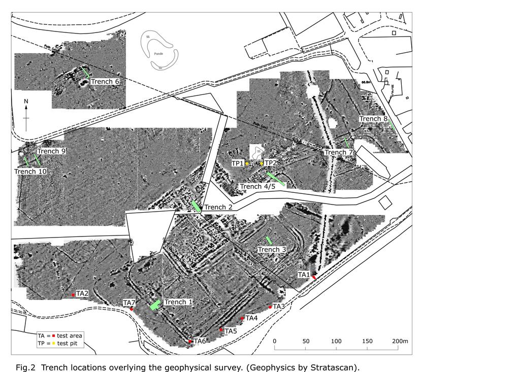
55
56
57
58
59
60
61
62
 with charred seeds in")

63 Plates Plate 1: Trench 1 - the inner defensive ditch (1003) with charred seeds in the primary fill, looking north Plate 2: Trench 1 General view following excavation looking southeast
 being excavated,")
 looking")
64 Plate 3: Trench 2 The Malvernian Ware pot (2003) being excavated, looking northwest Plate 4: Trench 2 the early ditch (2047) looking north.


65 Plate 5: Trench 2 Post excavation Plate 6: Trench 3 Volunteers at work

66 Plate 7: Trench 3 post-excavation Plate 8: Trench 4/5 Cadw visitors being shown the excavation in progress


67 Plate 9: Trench 4/5 the pottery packed feature (4026) Plate 10: Trench 4/5 the ditch (4015)


68 Plate 11: Trench 4/5 post excavation Plate 12: Trench 6 showing area of brick
EXCAVATION OF A BRONZE AGE ROUND BARROW (PRN 55928) AT PANT Y BUTLER, LLANGOEDMOR, CEREDIGION, 2010
 AT PANT Y BUTLER, LLANGOEDMOR, CEREDIGION, 2010") EXCAVATION OF A BRONZE AGE ROUND BARROW (PRN 55928) AT PANT Y BUTLER, LLANGOEDMOR, CEREDIGION, 2010 Prepared by Dyfed Archaeological Trust For: CADW 1 DYFED ARCHAEOLOGICAL TRUST RHIF YR ADRODDIAD / REPORT
EXCAVATION OF A BRONZE AGE ROUND BARROW (PRN 55928) AT PANT Y BUTLER, LLANGOEDMOR, CEREDIGION, 2010 Prepared by Dyfed Archaeological Trust For: CADW 1 DYFED ARCHAEOLOGICAL TRUST RHIF YR ADRODDIAD / REPORT
An archaeological evaluation at the Lexden Wood Golf Club (Westhouse Farm), Lexden, Colchester, Essex
, Lexden, Colchester, Essex") An archaeological evaluation at the Lexden Wood Golf Club (Westhouse Farm), Lexden, Colchester, Essex January 2000 Archive report on behalf of Lexden Wood Golf Club Colchester Archaeological Trust 12 Lexden
An archaeological evaluation at the Lexden Wood Golf Club (Westhouse Farm), Lexden, Colchester, Essex January 2000 Archive report on behalf of Lexden Wood Golf Club Colchester Archaeological Trust 12 Lexden
ARCHAEOLOGICAL EVALUATION AT BRIGHTON POLYTECHNIC, NORTH FIELD SITE, VARLEY HALLS, COLDEAN LANE, BRIGHTON. by Ian Greig MA AIFA.
 ARCHAEOLOGICAL EVALUATION AT BRIGHTON POLYTECHNIC, NORTH FIELD SITE, VARLEY HALLS, COLDEAN LANE, BRIGHTON by Ian Greig MA AIFA May 1992 South Eastern Archaeological Services Field Archaeology Unit White
Colchester Archaeological Trust Ltd. A Fieldwalking Survey at Birch, Colchester for ARC Southern Ltd
 Colchester Archaeological Trust Ltd A Fieldwalking Survey at Birch, Colchester for ARC Southern Ltd November 1997 CONTENTS page Summary... 1 Background... 1 Methods... 1 Retrieval Policy... 2 Conditions...
An archaeological watching brief and recording at Brightlingsea Quarry, Moverons Lane, Brightlingsea, Essex October 2003
 An archaeological watching brief and recording at Brightlingsea Quarry, Moverons Lane, Brightlingsea, Essex commissioned by Mineral Services Ltd on behalf of Alresford Sand & Ballast Co Ltd report prepared
New Composting Centre, Ashgrove Farm, Ardley, Oxfordshire
 New Composting Centre, Ashgrove Farm, Ardley, Oxfordshire An Archaeological Watching Brief For Agrivert Limited by Andrew Weale Thames Valley Archaeological Services Ltd Site Code AFA 09/20 August 2009
Fieldwalking at Cottam 1994 (COT94F)
") Fieldwalking at Cottam 1994 (COT94F) Tony Austin & Elizabeth Jelley (19 Jan 29) 1. Introduction During the winter of 1994 students from the Department of Archaeology at the University of York undertook
Fieldwalking at Cottam 1994 (COT94F) Tony Austin & Elizabeth Jelley (19 Jan 29) 1. Introduction During the winter of 1994 students from the Department of Archaeology at the University of York undertook
An archaeological evaluation at 16 Seaview Road, Brightlingsea, Essex February 2004
 An archaeological evaluation at 16 Seaview Road, Brightlingsea, Essex February 2004 report prepared by Kate Orr on behalf of Highfield Homes NGR: TM 086 174 (c) CAT project ref.: 04/2b ECC HAMP group site
An archaeological evaluation in the playground of Colchester Royal Grammar School, Lexden Road, Colchester, Essex
 An archaeological evaluation in the playground of Colchester Royal Grammar School, Lexden Road, Colchester, Essex February 2002 on behalf of Roff Marsh Partnership CAT project code: 02/2c Colchester Museum
Cetamura Results
 Cetamura 2000 2006 Results A major project during the years 2000-2006 was the excavation to bedrock of two large and deep units located on an escarpment between Zone I and Zone II (fig. 1 and fig. 2);
Greater London GREATER LONDON 3/606 (E ) TQ
 TQ") GREATER LONDON City of London 3/606 (E.01.6024) TQ 30358150 1 PLOUGH PLACE, CITY OF LONDON An Archaeological Watching Brief at 1 Plough Place, City of London, London EC4 Butler, J London : Pre-Construct
GREATER LONDON City of London 3/606 (E.01.6024) TQ 30358150 1 PLOUGH PLACE, CITY OF LONDON An Archaeological Watching Brief at 1 Plough Place, City of London, London EC4 Butler, J London : Pre-Construct
Grim s Ditch, Starveall Farm, Wootton, Woodstock, Oxfordshire
 Grim s Ditch, Starveall Farm, Wootton, Woodstock, Oxfordshire An Archaeological Recording Action For Empire Homes by Steve Ford Thames Valley Archaeological Services Ltd Site Code SFW06/118 November 2006
39, Walnut Tree Lane, Sudbury (SUY 073) Planning Application No. B/04/02019/FUL Archaeological Monitoring Report No. 2005/112 OASIS ID no.
 Planning Application No. B/04/02019/FUL Archaeological Monitoring Report No. 2005/112 OASIS ID no.") 39, Walnut Tree Lane, Sudbury (SUY 073) Planning Application No. B/04/02019/FUL Archaeological Monitoring Report No. 2005/112 OASIS ID no. 9273 Summary Sudbury, 39, Walnut Tree Lane, Sudbury (TL/869412;
39, Walnut Tree Lane, Sudbury (SUY 073) Planning Application No. B/04/02019/FUL Archaeological Monitoring Report No. 2005/112 OASIS ID no. 9273 Summary Sudbury, 39, Walnut Tree Lane, Sudbury (TL/869412;
SALVAGE EXCAVATIONS AT OLD DOWN FARM, EAST MEON
 Proc. Hants. Field Club Archaeol. Soc. 36, 1980, 153-160. 153 SALVAGE EXCAVATIONS AT OLD DOWN FARM, EAST MEON By RICHARD WHINNEY AND GEORGE WALKER INTRODUCTION The site was discovered by chance in December
2 Saxon Way, Old Windsor, Berkshire
 2 Saxon Way, Old Windsor, Berkshire An Archaeological Watching Brief For Mrs J. McGillicuddy by Pamela Jenkins Thames Valley Archaeological Services Ltd Site Code SWO 05/67 August 2005 Summary Site name:
Church of St Peter and St Paul, Great Missenden, Buckinghamshire
 Church of St Peter and St Paul, Great Missenden, Buckinghamshire An Archaeological Watching Brief for the Parish of Great Missenden by Andrew Taylor Thames Valley Archaeological Services Ltd Site Code
Former Whitbread Training Centre Site, Abbey Street, Faversham, Kent Interim Archaeological Report Phase 1 November 2009
 Former Whitbread Training Centre Site, Abbey Street, Faversham, Kent Interim Archaeological Report Phase 1 November 2009 SWAT. Archaeology Swale and Thames Archaeological Survey Company School Farm Oast,
Test-Pit 3: 31 Park Street (SK )
") -Pit 3: 31 Park Street (SK 40732 03178) -Pit 3 was excavated in a flower bed in the rear garden of 31 Park Street, on the northern side of the street and west of an alleyway leading to St Peter s Church,
-Pit 3: 31 Park Street (SK 40732 03178) -Pit 3 was excavated in a flower bed in the rear garden of 31 Park Street, on the northern side of the street and west of an alleyway leading to St Peter s Church,
Cambridge Archaeology Field Group. Fieldwalking on the Childerley Estate, Cambridgeshire. Autumn 2014 to Spring Third interim report
 Cambridge Archaeology Field Group Fieldwalking on the Childerley Estate, Cambridgeshire Autumn 2014 to Spring 2015 Third interim report Summary Field walking on the Childerley estate of Martin Jenkins
Fort Arbeia and the Roman Empire in Britain 2012 FIELD REPORT
 Fort Arbeia and the Roman Empire in Britain 2012 FIELD REPORT Background Information Lead PI: Paul Bidwell Report completed by: Paul Bidwell Period Covered by this report: 17 June to 25 August 2012 Date
3. The new face of Bronze Age pottery Jacinta Kiely and Bruce Sutton
 3. The new face of Bronze Age pottery Jacinta Kiely and Bruce Sutton Illus. 1 Location map of Early Bronze Age site at Mitchelstown, Co. Cork (based on the Ordnance Survey Ireland map) A previously unknown
Bangor University. The Meillionydd Project: Characterising the double ringwork enclosures in Gwynedd Preliminary Excavation Report
 Bangor University The Meillionydd Project: Characterising the double ringwork enclosures in Gwynedd Preliminary Excavation Report Kate Waddington and Raimund Karl Bangor, August 2010 Contents Acknowledements
Archaeological sites and find spots in the parish of Burghclere - SMR no. OS Grid Ref. Site Name Classification Period
 Archaeological sites and find spots in the parish of Burghclere - SMR no. OS Grid Ref. Site Name Classification Period SU45NE 1A SU46880 59200 Ridgemoor Farm Inhumation Burial At Ridgemoor Farm, on the
Cambridge Archaeology Field Group. Fieldwalking on the Childerley Estate Cambridgeshire
 Cambridge Archaeology Field Group Fieldwalking on the Childerley Estate Cambridgeshire 2009 to 2014 Summary Fieldwalking on the Childerley estate of Martin Jenkins and Family has revealed, up to March
Moray Archaeology For All Project
 School children learning how to identify finds. (Above) A flint tool found at Clarkly Hill. Copyright: Leanne Demay Moray Archaeology For All Project ational Museums Scotland have been excavating in Moray
Chapter 2. Remains. Fig.17 Map of Krang Kor site
 Chapter 2. Remains Section 1. Overview of the Survey Area The survey began in January 2010 by exploring the site of the burial rootings based on information of the rooted burials that was brought to the
Monitoring Report No Sacred Heart Church Aghamore Boho Co. Fermanagh AE/10/116E. Brian Sloan L/2009/1262/F
 Monitoring Report No. 202 Sacred Heart Church Aghamore Boho Co. Fermanagh AE/10/116E Brian Sloan L/2009/1262/F Site Specific Information Site Address: Sacred Heart Church, Aghamore, Boho, Co. Fermanagh
An archaeological watching brief at Sheepen, Colchester, Essex November-December 2003
 An archaeological watching brief at Sheepen, Colchester, Essex November-December 2003 report prepared by Ben Holloway on behalf of Colchester Borough Council CAT project ref.: 03/11c Colchester Museums
7. Prehistoric features and an early medieval enclosure at Coonagh West, Co. Limerick Kate Taylor
 7. Prehistoric features and an early medieval enclosure at Coonagh West, Co. Limerick Kate Taylor Illus. 1 Location of the site in Coonagh West, Co. Limerick (based on the Ordnance Survey Ireland map)
FURTHER MIDDLE SAXON EVIDENCE AT COOK STREET, SOUTHAMPTON (SOU 567)
") Roc. Hampshire Field Club Archaeol. Soc 52,1997, 77-87 (Hampshire Studies 1997) FURTHER MIDDLE SAXON EVIDENCE AT COOK STREET, SOUTHAMPTON (SOU 567) By M F GARNER andj VINCENT with a contribution byjacqueline
Roc. Hampshire Field Club Archaeol. Soc 52,1997, 77-87 (Hampshire Studies 1997) FURTHER MIDDLE SAXON EVIDENCE AT COOK STREET, SOUTHAMPTON (SOU 567) By M F GARNER andj VINCENT with a contribution byjacqueline
A Sense of Place Tor Enclosures
 A Sense of Place Tor Enclosures Tor enclosures were built around six thousand years ago (4000 BC) in the early part of the Neolithic period. They are large enclosures defined by stony banks sited on hilltops
Silwood Farm, Silwood Park, Cheapside Road, Ascot, Berkshire
 Silwood Farm, Silwood Park, Cheapside Road, Ascot, Berkshire An Archaeological Watching Brief For Imperial College London by Tim Dawson Thames Valley Archaeological Services Ltd Site Code SFA 09/10 April
St Germains, Tranent, East Lothian: the excavation of Early Bronze Age remains and Iron Age enclosed and unenclosed settlements
 Proc Soc Antiq Scot, 128 (1998), 203-254 St Germains, Tranent, East Lothian: the excavation of Early Bronze Age remains and Iron Age enclosed and unenclosed settlements Derek Alexander* & Trevor Watkinsf
Chapter 2: Archaeological Description
 Chapter 2: Archaeological Description Phase 1 Late Neolithic, c 3000-2400 BC (Figs 6-9) Evidence of Neolithic activity was confined to pits dug across the southern half of the site (Fig. 6). Eighteen pits
THE PRE-CONQUEST COFFINS FROM SWINEGATE AND 18 BACK SWINEGATE
 THE PRE-CONQUEST COFFINS FROM 12 18 SWINEGATE AND 18 BACK SWINEGATE An Insight Report By J.M. McComish York Archaeological Trust for Excavation and Research (2015) Contents 1. INTRODUCTION... 3 2. THE
THE PEMBROKESHIRE CEMETERIES PROJECT
 THE PEMBROKESHIRE CEMETERIES PROJECT EXCAVATIONS AT PORTHCLEW CHAPEL FRESHWATER EAST PEMBROKESHIRE 2008 INTERIM REPORT DYFED ARCHAEOLOGICAL TRUST RHIF YR ADRODDIAD / REPORT NO. 2009/17 RHIF Y PROSIECT
Monitoring Report No. 99
 Monitoring Report No. 99 Enniskillen Castle Co. Fermanagh AE/06/23 Cormac McSparron Site Specific Information Site Name: Townland: Enniskillen Castle Enniskillen SMR No: FER 211:039 Grid Ref: County: Excavation
Greater London Region GREATER LONDON 3/567 (E.01.K099) TQ BERMONDSEY STREET AND GIFCO BUILDING AND CAR PARK
 TQ BERMONDSEY STREET AND GIFCO BUILDING AND CAR PARK") GREATER LONDON 3/567 (E.01.K099) TQ 33307955 156-170 BERMONDSEY STREET AND GIFCO BUILDING AND CAR PARK Assessment of an Archaeological Excavation at 156-170 Bermondsey Street and GIFCO Building and Car
GREATER LONDON 3/567 (E.01.K099) TQ 33307955 156-170 BERMONDSEY STREET AND GIFCO BUILDING AND CAR PARK Assessment of an Archaeological Excavation at 156-170 Bermondsey Street and GIFCO Building and Car
Excavations of Late Iron Age and Roman features and a Roman road north of Gosbecks Archaeological Park, Colchester, Essex
 Excavations of Late Iron Age and Roman features and a Roman road north of Gosbecks Archaeological Park, Colchester, Essex 1995-1996 report by Stephen Benfield with contributions from Justine Bailey, Peter
Excavations at Shikarpur, Gujarat
 Excavations at Shikarpur, Gujarat 2008-2009 The Department of Archaeology and Ancient History, the M. S. University of Baroda continued excavations at Shikarpur in the second field season in 2008-09. In
Archaeological. Monitoring & Recording Report. Fulbourn Primary School, Cambridgeshire. Archaeological Monitoring & Recording Report.
 Fulbourn Primary School, Cambridgeshire Archaeological Monitoring & Recording Report October 2014 Client: Cambridgeshire County Council OA East Report No: 1689 OASIS No: oxfordar3-192890 NGR: TL 5190 5613
Wantage County Primary School, Garston Lane, Wantage, Oxfordshire
 Wantage County Primary School, Garston Lane, Wantage, Oxfordshire An Archaeological Evaluation for Oxfordshire County Council by Erlend Hindmarch Thames Valley Archaeological Services Ltd Site Code GLW
Archaeological Watching Brief (Phase 2) at Court Lodge Farm, Aldington, near Ashford, Kent December 2011
 at Court Lodge Farm, Aldington, near Ashford, Kent December 2011") Archaeological Watching Brief (Phase 2) at Court Lodge Farm, Aldington, near Ashford, Kent December 2011 SWAT. Archaeology Swale and Thames Archaeological Survey Company School Farm Oast, Graveney Road
Archaeological Watching Brief (Phase 2) at Court Lodge Farm, Aldington, near Ashford, Kent December 2011 SWAT. Archaeology Swale and Thames Archaeological Survey Company School Farm Oast, Graveney Road
A NEW ROMAN SITE IN CHESHAM
 A NEW ROMAN SITE IN CHESHAM KEITH BRANIGAN AND MICHAEL KIRTON THE site under discussion was first noted in 1958 and since that time several discoveries have been made. Its investigation has been pursued
STONE implements and pottery indicative of Late Neolithic settlement are known to
 Late Neolithic Site in the Extreme Northwest of the New Territories, Hong Kong Received 29 July 1966 T. N. CHIU* AND M. K. WOO** THE SITE STONE implements and pottery indicative of Late Neolithic settlement
STONES OF STENNESS HISTORIC ENVIRONMENT SCOTLAND STATEMENT OF SIGNIFICANCE
 Property in Care (PIC) ID: PIC321 Designations: Scheduled Monument (SM90285); Taken into State care: 1906 (Guardianship) Last reviewed: 2003 HISTORIC ENVIRONMENT SCOTLAND STATEMENT OF SIGNIFICANCE STONES
TAI COCHION AND TREFARTHEN ROMAN SETTLEMENT
 1037 TAI COCHION AND TREFARTHEN ROMAN SETTLEMENT Interim Excavation Report Ymddiriedolaeth Archaeolegol Gwynedd Gwynedd Archaeological Trust TAI COCHION AND TREFARTHEN ROMAN SETTLEMENT Interim Excavation
An archaeological evaluation at the Blackwater Hotel, Church Road, West Mersea, Colchester, Essex March 2003
 An archaeological evaluation at the Blackwater Hotel, Church Road, West Mersea, Colchester, Essex report prepared by Laura Pooley on behalf of Dolphin Developments (U.K) Ltd NGR: TM 0082 1259 CAT project
Essex Historic Environment Record/ Essex Archaeology and History
 Essex Historic Environment Record/ Essex Archaeology and History CAT Report 578 Summary sheet Address: Kingswode Hoe School, Sussex Road, Colchester, Essex Parish: Colchester NGR: TL 9835 2528 Type of
17 Phase 5. High and Late medieval features and activities AD
 17 Phase 5. High and Late medieval features and activities 1200 1550 AD 17.1 Results This time phase is based on all findings that can be placed in the High and Late medieval period 1200 1550 AD based
The excavation of a coastal promontory fort at Porth y Rhaw, Solva, Pembrokeshire,
 Archaeologia Cambrensis 159 (2010), 53 98 The excavation of a coastal promontory fort at Porth y Rhaw, Solva, Pembrokeshire, 1995 98 By PETE CRANE and KENNETH MURPHY 1 with contributions by A. E. Caseldine
An archaeological watching brief on one section of an Anglian Water main Spring Lane, Lexden, Colchester
 An archaeological watching brief on one section of an Anglian Water main Spring Lane, Lexden, Colchester April-September 2001 on behalf of Breheny Contractors CAT project ref.: 01/4D Colchester Museum
Grange Farm, Widmer End, Hughenden, Buckinghamshire
 Grange Farm, Widmer End, Hughenden, Buckinghamshire An Archaeological Evaluation for British Flora by Andy Taylor Thames Valley Archaeological Services Ltd Site Code GFH 05/63 July 2005 Summary Site name:
Archaeological trial-trenching evaluation at Chappel Farm, Little Totham, Essex. April 2013
 Archaeological trial-trenching evaluation at Chappel Farm, Little Totham, Essex April 2013 report prepared by Ben Holloway commissioned by Tim Harbord Associates on behalf of Mr Tom Howie Planning reference:
Hen Gastell, Llanwnda A Medieval Defended Site
 Hen Gastell, Llanwnda A Medieval Defended Site Summary of Excavation Report Ymddiriedolaeth Archaeolegol Gwynedd Gwynedd Archaeological Trust 47 46 48 Crown Copyright and database right 2016. Ordnance
1. Presumed Location of French Soundings Looking NW from the banks of the river.
 SG02? SGS SG01? SG4 1. Presumed Location of French Soundings Looking NW from the banks of the river. The presumed location of SG02 corresponds to a hump known locally as the Sheikh's tomb. Note also (1)
A visit to the Wor Barrow 21 st November 2015
 A visit to the Wor Barrow 21 st November 2015 Following our exploration of Winkelbury a few weeks previously, we fast forwarded 12 years in Pitt Rivers remarkable series of excavations and followed him
ROMAN AND MEDIEVAL ACTIVITY IN THE UPPER WALBROOK VALLEY: EXCAVATIONS AT MOORGATE, CITY OF LONDON, EC2, 1997
 ROMAN AND MEDIEVAL ACTIVITY IN THE UPPER WALBROOK VALLEY: EXCAVATIONS AT 12 18 MOORGATE, CITY OF LONDON, EC2, 1997 Graham Bruce, Dominic Perring, Tim Stevens and Melissa Melikian SUMMARY In January and
TIPPERARY HISTORICAL JOURNAL 1994
 TPPERARY HSTORCAL JOURNAL 1994 County Tipperary Historical Society www.tipperarylibraries.ie/ths society@tipperarylibraries. ie SSN 0791-0655 Excavations at Cormac's Chapel, Cashel, 1992 and 1993: a preliminary
Bronze-Age and Romano-British Sites South-East of Tewkesbury: evaluations and excavations
 From the Transactions of the Bristol and Gloucestershire Archaeological Society Bronze-Age and Romano-British Sites South-East of Tewkesbury: evaluations and excavations 1991-7 by G. Walker, A. Thomas
LAND AT LLANEGWAD, CARMARTHENSHIRE: ARCHAEOLOGICAL EXCAVATION 2007
 LAND AT LLANEGWAD, CARMARTHENSHIRE: ARCHAEOLOGICAL EXCAVATION 2007 Prepared by Dyfed Archaeological Trust For: Davies Richards DYFED ARCHAEOLOGICAL TRUST RHIF YR ADRODDIAD / REPORT NO. 2008/70 RHIF Y PROSIECT
Control ID: Years of experience: Tools used to excavate the grave: Did the participant sieve the fill: Weather conditions: Time taken: Observations:
 Control ID: Control 001 Years of experience: No archaeological experience Tools used to excavate the grave: Trowel, hand shovel and shovel Did the participant sieve the fill: Yes Weather conditions: Flurries
ARCHAEOLOGICAL MONITORING REPORT
 ARCHAEOLOGICAL MONITORING REPORT SCCAS REPORT No. 2009/324 Thorington Hall, Stoke by Nayland SBN 087 HER Information Date of Fieldwork: November 2009 - January 2010 Grid Reference: TM 0131 3546 Funding
CUMBRIA 2/635 (C ) NY
 NY") CUMBRIA Allerdale 2/635 (C.16.6017) NY 11803070 BRIDGE STREET, COCKERMOUTH Report on an Archaeological Evaluation at Bridge Street, Cockermouth, Cumbria (Report No. 5/00) Grahame, R Carlisle : Carlisle
CUMBRIA Allerdale 2/635 (C.16.6017) NY 11803070 BRIDGE STREET, COCKERMOUTH Report on an Archaeological Evaluation at Bridge Street, Cockermouth, Cumbria (Report No. 5/00) Grahame, R Carlisle : Carlisle
LAND WEST OF ELM GROVE, EBRINGTON, GLOUCESTERSHIRE. NGR: SP (centred) ARCHAEOLOGICAL EVALUATION
 ARCHAEOLOGICAL EVALUATION") LAND WEST OF ELM GROVE, EBRINGTON, GLOUCESTERSHIRE. NGR: SP 1892 4012 (centred) ARCHAEOLOGICAL EVALUATION Report No. 640 May 2009 1q LAND WEST OF ELM GROVE, EBRINGTON, GLOUCESTERSHIRE. NGR: SP 1892 4012
LAND WEST OF ELM GROVE, EBRINGTON, GLOUCESTERSHIRE. NGR: SP 1892 4012 (centred) ARCHAEOLOGICAL EVALUATION Report No. 640 May 2009 1q LAND WEST OF ELM GROVE, EBRINGTON, GLOUCESTERSHIRE. NGR: SP 1892 4012
Moated Site at Manor Farm, Islip, Oxfordshire
 Moated Site at Manor Farm, Islip, Oxfordshire An Archaeological Excavation By Jo Pine Site Code MFI05 December 2007 Summary Site name: Moated Site at Manor Farm, Islip, Oxfordshire Grid reference: SP 5298
Undley Hall, Lakenheath LKH 307
 ARCHAEOLOGICAL EVALUATION AND MONITORING REPORT SCCAS REPORT No. 2010/005 Undley Hall, Lakenheath LKH 307 E. Muldowney SCCAS January 2010 www.suffolkcc.gov.uk/e-and-t/archaeology Lucy Robinson, County
Peace Hall, Sydney Town Hall Results of Archaeological Program (Interim Report)
") Results of Archaeological Program (Interim Report) Background The proposed excavation of a services basement in the western half of the Peace Hall led to the archaeological investigation of the space in
Results of Archaeological Program (Interim Report) Background The proposed excavation of a services basement in the western half of the Peace Hall led to the archaeological investigation of the space in
Tell Shiyukh Tahtani (North Syria)
") Tell Shiyukh Tahtani (North Syria) Report of the 2010 excavation season conducted by the University of Palermo Euphrates Expedition by Gioacchino Falsone and Paola Sconzo In the summer 2010 the University
Tell Shiyukh Tahtani (North Syria) Report of the 2010 excavation season conducted by the University of Palermo Euphrates Expedition by Gioacchino Falsone and Paola Sconzo In the summer 2010 the University
An archaeological evaluation by trial-trenching at Playgolf, Bakers Lane, Westhouse Farm, Colchester, Essex
 An archaeological evaluation by trial-trenching at Playgolf, Bakers Lane, Westhouse Farm, Colchester, Essex commissioned by Mr Stephen Belchem on behalf of ADP Ltd. report prepared by Chris Lister Planning
Caistor Roman Project Interim Summary of 2015 Season of Test pits at Caistor Old Hall
 Caistor Roman Project Interim Summary of 2015 Season of Test pits at Caistor Old Hall Introduction This brief report summarises the first results of the 2015 campaign of test-pitting in the grounds of
Phase 2 Urban consolidation AD
 Phase 2 Urban consolidation AD 1250-1350 The second recognised phase of activity at Rådhuspladsen corresponded approximately to the High medieval period (c. AD 1250 1350), and saw consolidation of the
Archaeological evaluation at the Onley Arms, The Street, Stisted, Essex
 Archaeological evaluation at the Onley Arms, The Street, Stisted, Essex November 2014 report by Pip Parmenter and Adam Wightman with a contribution from Stephen Benfield and illustrations by Emma Holloway
WESTSIDE CHURCH (TUQUOY)
") Property in Care (PIC) ID: PIC324 Designations: Scheduled Monument (SM90312) Taken into State care: 1933 (Guardianship) Last reviewed: 2004 HISTORIC ENVIRONMENT SCOTLAND STATEMENT OF SIGNIFICANCE WESTSIDE
Property in Care (PIC) ID: PIC324 Designations: Scheduled Monument (SM90312) Taken into State care: 1933 (Guardianship) Last reviewed: 2004 HISTORIC ENVIRONMENT SCOTLAND STATEMENT OF SIGNIFICANCE WESTSIDE
Suburban life in Roman Durnovaria
 Suburban life in Roman Durnovaria Additional specialist report Finds Ceramic building material By Kayt Brown Ceramic building material (CBM) Kayt Brown A total of 16420 fragments (926743g) of Roman ceramic
1 The East Oxford Archaeology and History Project
 1 The East Oxford Archaeology and History Project EXOP TEST PIT 72 Location: Bartlemas Chapel, Cowley Date of excavation: 6-8 November 2013. Area of excavation: 0.8m x 1.2m, at the eastern end of the chapel.
Chapel House Wood Landscape Project. Interim Report 2013
 Chapel House Wood Landscape Project Interim Report 2013 Chapel House Wood Landscape Project Interim Report 2013 The annual Dales Heritage Field School was held at Chapel House Wood again this year, and
Forteviot, Perthshire: Excavations at the Entrance Avenue of the Neolithic Palisaded Enclosure Interim Report and Data Structure Report
 Forteviot, Perthshire: Excavations at the Entrance Avenue of the Neolithic Palisaded Enclosure 2007 Interim Report and Data Structure Report by Gordon Noble and Kenneth Brophy Table of Contents Summary
Changing People Changing Landscapes: excavations at The Carrick, Midross, Loch Lomond Gavin MacGregor, University of Glasgow
 Changing People Changing Landscapes: excavations at The Carrick, Midross, Loch Lomond Gavin MacGregor, University of Glasgow Located approximately 40 kilometres to the south-west of Oban, as the crow flies
Archaeological Material From Spa Ghyll Farm, Aldfield
 Archaeological Material From Spa Ghyll Farm, Aldfield Introduction Following discussions with Linda Smith the Rural Archaeologist for North Yorkshire County Council, Robert Morgan of 3D Archaeological
Forteviot, Palisaded Enclosure Excavations Data Structure Report. By Aoife Gould
 Forteviot, Palisaded Enclosure Excavations 2010 Data Structure Report By Aoife Gould Table of Contents Summary 2 Introduction 2 Location 2 Archaeological Background 4 Aims 4 Methodology 5 Results 8 Subsoil
T so far, by any other ruins in southwestern New Mexico. However, as
 TWO MIMBRES RIVER RUINS By EDITHA L. WATSON HE ruins along the Mimbres river offer material for study unequaled, T so far, by any other ruins in southwestern New Mexico. However, as these sites are being
Barnet Battlefield Survey
 In terim report on the progress of the Barnet Battlefield Survey December 2016 The Barnet Battlefield Survey is an archaeological investigation into the 1471 Battle of Barnet. It aims to define more accurately
Is this the Original Anglo-Saxon period site of Weathercote?
 Is this the Original Anglo-Saxon period site of Weathercote? A Batty & N Crack 2016 Front Cover. Looking south east across proposed original site of Weathercote. Photograph A 2 3 Weathercote Anglo-Saxon
MARSTON MICHAEL FARLEY
 MARSTON MICHAEL FARLEY On 9 March agricultural contractors, laying field drains for Bucks County Council Land Agent's Department, cut through a limestone structure at SP 75852301 in an area otherwise consistently
Lanton Lithic Assessment
 Lanton Lithic Assessment Dr Clive Waddington ARS Ltd The section headings in the following assessment report refer to those in the Management of Archaeological Projects (HBMC 1991), Appendix 4. 1. FACTUAL
The Jamesford Coin Hoard, Montgomery
 CPAT Report No 1121 GEOPHYSICAL SURVEY AND EXCAVATION THE CLWYD-POWYS ARCHAEOLOGICAL TRUST CPAT Report No 1121 GEOPHYSICAL SURVEY AND EXCAVATION N W Jones, I Grant and R Hankinson January 2012 Report for
FAN FOEL ROUND BARROW, MYNYDD DU
 FAN FOEL ROUND BARROW, MYNYDD DU AN ARCHAEOLOGICAL EXCAVATION, JUNE 2004 Interim report Paratowyd gan Archaeoleg Cambria Ar gyfer Cadw a Parc Cenedlaethol Bannau Brycheiniog Prepared by Cambria Archaeology
SERIATION: Ordering Archaeological Evidence by Stylistic Differences
 SERIATION: Ordering Archaeological Evidence by Stylistic Differences Seriation During the early stages of archaeological research in a given region, archaeologists often encounter objects or assemblages
Evidence for the use of bronze mining tools in the Bronze Age copper mines on the Great Orme, Llandudno
 Evidence for the use of bronze mining tools in the Bronze Age copper mines on the Great Orme, Llandudno Background The possible use of bronze mining tools has been widely debated since the discovery of
Bronze Age 2, BC
 Bronze Age 2,000-600 BC There may be continuity with the Neolithic period in the Early Bronze Age, with the harbour being used for seasonal grazing, and perhaps butchering and hide preparation. In the
Excavation of Iron-Age and Roman Occupation at Coln Gravel, Thornhill Farm,Fairford, Gloucestershire, 2003 and 2004.
 From the Transactions of the Bristol and Gloucestershire Archaeological Society Excavation of Iron-Age and Roman Occupation at Coln Gravel, Thornhill Farm,Fairford, Gloucestershire, 2003 and 2004. by Dan
An archaeological watching brief and evaluation at Great Notley business park, near Braintree, Essex June-September 2005
 An archaeological watching brief and evaluation at Great Notley business park, near Braintree, Essex report prepared by Kate Orr commissioned by Andrew Martin Associates Ltd on behalf of Countryside Properties
A R C H A E O L O G Y. N o. 3 NORTH WEST CAMBRIDGE (2) EXCAVATIONS Assessment Report Craig Cessford and Christopher Evans
 EXCAVATIONS Assessment Report Craig Cessford and Christopher Evans") NORTH WEST CAMBRIDGE A R C H A E O L O G Y 2012-13 EXCAVATIONS Assessment Report Craig Cessford and Christopher Evans N o. 3 (2) NORTH WEST CAMBRIDGE ARCHAEOLOGY University of Cambridge 2012 13 Excavations
NORTH WEST CAMBRIDGE A R C H A E O L O G Y 2012-13 EXCAVATIONS Assessment Report Craig Cessford and Christopher Evans N o. 3 (2) NORTH WEST CAMBRIDGE ARCHAEOLOGY University of Cambridge 2012 13 Excavations
Foreign Whaling in Iceland Archaeological Excavations at Strákatangi in Hveravík, Kaldrananeshreppi 2007 Data Structure Report
 Foreign Whaling in Iceland Archaeological Excavations at Strákatangi in Hveravík, Kaldrananeshreppi 2007 Data Structure Report Caroline Paulsen, Magnús Rafnsson and Ragnar Edvardsson February 2008 NV nr.
Novington, Plumpton East Sussex
 Novington, Plumpton East Sussex The Flint Over 1000 pieces of flintwork were recovered during the survey, and are summarised in Table 0. The flint is of the same types as found in the previous survey of
Human remains from Estark, Iran, 2017
 Bioarchaeology of the Near East, 11:84 89 (2017) Short fieldwork report Human remains from Estark, Iran, 2017 Arkadiusz Sołtysiak *1, Javad Hosseinzadeh 2, Mohsen Javeri 2, Agata Bebel 1 1 Department of
AREA C. HENRY 0. THOMPSON American Center of Oriental Research Amman, Jordan
 AREA C HENRY 0. THOMPSON American Center of Oriental Research Amman, Jordan Of the 1971 work previously reported,' Squares 4,5, and 6 were not excavated in 1973, but work in Squares 1, 2, and 3 was continued.
FEATURE DESCRIPTIONS: PART 1. SAN AGUSTÍN MISSION LOCUS, THE CLEARWATER SITE, AZ BB:13:6 (ASM)
") CHAPTER 4 FEATURE DESCRIPTIONS: PART 1. SAN AGUSTÍN MISSION LOCUS, THE CLEARWATER SITE, AZ BB:13:6 (ASM) Thomas Klimas, Caramia Williams, and J. Homer Thiel Desert Archaeology, Inc. Archaeological work
CHAPTER 4 FEATURE DESCRIPTIONS: PART 1. SAN AGUSTÍN MISSION LOCUS, THE CLEARWATER SITE, AZ BB:13:6 (ASM) Thomas Klimas, Caramia Williams, and J. Homer Thiel Desert Archaeology, Inc. Archaeological work
Whitton Church Lane (Recreation Ground) WHI 014
 WHI 014") ARCHAEOLOGICAL EVALUATION REPORT Whitton Church Lane (Recreation Ground) WHI 014 A REPORT ON THE ARCHAEOLOGICAL EVALUATION, 2008 (Planning app. no. 1362/05/FUL) Jezz Meredith Field Team Suffolk C.C. Archaeological
ARCHAEOLOGICAL EVALUATION REPORT Whitton Church Lane (Recreation Ground) WHI 014 A REPORT ON THE ARCHAEOLOGICAL EVALUATION, 2008 (Planning app. no. 1362/05/FUL) Jezz Meredith Field Team Suffolk C.C. Archaeological