The earliest well in Estonia? Archaeological studies at Põltsamaa Kuningamägi, central Estonia
|
|
|
- Veronica Cox
- 5 years ago
- Views:
Transcription


, west from Põltsamaa town in central Estonia.")


.")


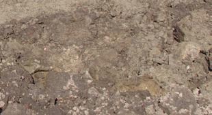
1 Archaeological Fieldwork in Estonia 2014, The earliest well in Estonia? Archaeological studies at Põltsamaa Kuningamägi, central Estonia Eesti Kirjandusmuuseum, folkloristika osakond (Estonian Literary Museum, Folklore Department), Vanemuise 42, Tartu, Estonia; INTRODUCTION In October 2013 a local metal detector enthusiast, Urmas Kuusik, was searching on the top of Kuningamägi hill (Eng. The King s Hill), west from Põltsamaa town in central Estonia. The main reason for that was the building activity by the local municipality, to make an artificial hill on the top of Kuningamägi drumlin for a sporting and recreation centre. The topsoil was removed and an about 15 m high artificial hill of building debris was piled at the place. During the removing of topsoil a dark and round area was unearthed which clearly distinguished from the rest of yellowish clayish moraine (Fig. 1). At first the dark area was considered as a depression caused by the fall of a bomb during WWII. Surprisingly an iron axe of a distinctive type was found in the middle of the dark area. In addition also an iron knife and Fig. 1. General view to the site. The depression, filled with meltwater is on the foreground. The central part of the soil rampart, made of ripped off topsoil on the background, is slightly darker with more stones visible. Jn 1. Üldvaade uuringute alale. Esiplaanil sulaveega täidetud süvend. Tagaplaanil kooritud pinnasest vall, mille keskne osa, süvendist välja lükatud pinnas on ümbritsevast tumedam, samuti on näha suuremaid kive. Photo / Foto:

.")
2 66 bridle bits were found from the same depression. During the clearance of the topsoil the distinctively darker soil from the depression was pushed to the edge of the cleared area. From this soil a bracelet, made of three bronze wires, was found together with some burnt bones and few potsherds. The axe (Fig. 2) was dated to the period around the beginning of the current era, the bracelet is typical to the 12th 13th century, the bridle bits and knife are undatable (Tvauri 2013, 3). Such a set of finds obviously demanded archaeological studies and so Andres Tvauri monitored the place in the autumn of 2013 (ibid.). No other metal finds were collected from the depression, but just some dozens of metres eastward from the depression several remains of Early Modern Age houses and fireplaces were found; also from the area where topsoil was ripped off. Among the finds from there ceramic gaming pieces, fragments of pipe, and a gilded fragment of a decoration were collected. It was decided that house remains had not been preserved sufficiently to give any substantially new data about its construction, but the depression was considered to need a more thorough examination (ibid.). THE KUNINGAMÄGI HILL The Kuningamägi hill has probably gained its name when the area became the residency of a small and short-time Livonian kingdom ( ), ruled by duke Magnus under the permission by the Russian tsar Ivan IV. The actual residency was not on the top of the Kuningamägi hill, but the duke had chosen the place on the northern end of the hill, which is more flat. However, the presence of power has given the name to the entire hill (Fig. 3). According to the earliest map available for that region from 1688 (EAA ), the studied place has been a field and no buildings are marked on this or later maps. It is probable that the Early Modern constructions, found by Andres Tvauri during the monitoring of the site, are slightly earlier and were already deserted by the time of the earliest map. But taking into account the gilded decoration the place was not some ordinary farmhouse. It is possible also that the place, the highest and most prominent in the landscape, was originally chosen for the residency of the Duke, but was removed later. The geology of the Kuningamägi hill is remarkable as well. As most of the hills in Estonia this also consists of moraine. But differently from many other moraine hills, Kuningamägi is not sandy, but clayish. From the moraine numerous pebbles of local Silurian flint could be found, still no worked pieces were recognized. THE FOLLOWING STUDIES 0 5 cm Fig. 2. An iron axe, found from Kuningamäe depression. Jn 2. Kaeluskirves Kuningamäe süvendist. (TÜ 2291.) Photo / Foto: Andres Vindi The soil rampart The first attempt to study the depression was made in late May 2014, however, it was still filled by melt water then. So, attention was concentrated on gathering finds from the removed topsoil that had been heaped up into a long rampart. To collect more finds the rampart was scattered in layers and every layer was controlled with metal detector. Unfortunately, no


3 The earliest well in Estonia? Archaeological studies at Põltsamaa Kuningamägi, central Estonia m Fig. 3. Map of the surroundings of Põltsamaa, including Kuningamägi; the trench is marked with a red circle. Jn 3. Põltsamaa ja Kuningamäe ümbruskond; kaevand on markeeritud punase ringiga. Drawing / Joonis: other finds except nails and pieces of melted iron (most probably remains of WWII bombs) were found. The only finds pieces of bones and some teeth of pigs were collected from the top layer. Thus they could easily originate from the depression, but equally also from the artificial hill nearby. Even though the future recreational hill was ought to be constructed of building waste only, a lot of household garbage was present. That made the context of the bones unsure and these were not collected. According to knowledge gained later, it can be said that bones probably originated from the depression. Despite of the lack of any finds a clearly observable selection of rocks was found (see Fig. 1). The rampart in general consisted mostly of pure soil and no rocks could be found. It was only in the area, where the soil from the depression was heaped, where numerous large rocks (around 60 cm in diameter) occurred in an area of 3 4 metres. In addition a lot of small pebbles, around 15 cm in diameter occurred as well, some of them carrying clear signs of burning. It is quite obvious that rocks and stones originated from the depression and had been placed there deliberately. Unfortunately no rocks were preserved in the depression and thus it was not possible to study their original layout. The depression By the beginning of August the depression had dried enough to start working there. Considering the rather hot and dry July in 2014 such slow drying of water on the top of the hill is remarkable. The depression was measured 7 8 metres, taken from the highest preserved level. It must be noted here that as the top layer was moved already, it was not possible to measure the original dimensions of the depression. In the north-east slope of the depression a small area of cm was discovered, which was covered with 1 cm thick layer of fish scales, belonging to the carp family (Cyprinidae).¹ Right beside the fish remains a small piece of Early Modern Age ceramics (TÜ 2443: 1) was found. Still, the find context of the pottery is not clear it may, but does not necessarily have to be connected with fish remains. The fish remains probably derive from a fish that has been descaled at the place and it is most likely not a waste thrown away. ¹ Determined by Lembi Lõugas (AI).
4 68 To study the large depression a 1-metre-wide NE SW-directional trench was dug through it and three main layers were distinguished in the centre (Fig. 4): 1) A 15 cm layer of grey and clayish mud mixed with garbage from the created hill; 2) A 45 cm layer of thick, very dark and humid mud, which was mixed with a lot of small pebbles, some burnt. Some remains of charcoal were present between the stones. Unexpectedly, pieces of striated pottery (Fig. 5) and some barely preserved bones were found between the stones; 3) Under that a natural, yellow and clayish moraine started. According to the results of the trench it was decided that it is not only a natural depression, but at least partly human-shaped. The soil between the stones was very humid and thus extremely dense. The combination of this kind of mud and small pebbles made the excavation very complicated and it was almost impossible to clean something in situ. The intense smell of the layer probably refers to the strong presence of organic material in the layer. As a result of the excavation of the trench it appeared that the bottom of the depression was conical, with a slope of about 20 degrees. In the middle of the depression a clearly distinguishable hollow appeared, with the dimensions of cm; its sharp edges indicate that it was artificially deepened. The deepening was very clearly observable at the western side, where a 12 cm high step appeared. The bottom of the deepest central point was 1.5 m below the surface. While the higher and conical part of the depression was filled with mud, the central and deeper section was in addition filled with pebbles, also pottery and bones were found from there. In addition, the iron axe, mentioned in the beginning of the article, was also found from the same place. While the axe was probably obtained a bit higher (it was excavated according to the metal detector signal and thus it is difficult to reconstruct its original depth), all the potsherds and bones were situated only in the bottom of the pit and were covered with stones. In the very bottom, partly in the natural clayish moraine layer a 10 3 cm piece of charcoal was found. Unfortunately it was so poorly preserved in this extremely humid environment that it was impossible to collect a sample for dating. Charcoal was also found from the slopes of the depression. Animal bones that were collected from the pit were poorly preserved as well, but could still be determined as belonging to a bovid.² To study the soil itself and particularly the smelling essence of it, two soil samples were taken for measuring the level of organic residues in it. Sample 1 was collected from the smelliest section in the very bottom of the depression, between the stones, pottery and bones. The sample for reference was collected from the eastern slope, about 40 cm higher. Both samples were dried, weighed and heated to burn out organic material and weighed again. A study conducted by a PhD student Triine Post from the Geology Department of the University of Tartu surprisingly revealed no difference and thus the smell of the layer had to originate from some other source and not the decomposing of organic material. INTERPRETATION OF THE SITE AND WELLS IN ESTONIAN PREHISTORY As a conclusion of fieldwork an interpretation formed that the depression was used for collecting rainwater. Probably some sort of natural depression formed the origin of this practice. Unfortunately the original dimensions of the depression cannot be followed any more. ² Pers. comm. Eve Rannamäe (TÜ).


, of the hollow, marking clearly an artificial deepening")


5 The earliest well in Estonia? Archaeological studies at Põltsamaa Kuningamägi, central Estonia 69 According to the studies it can be stated that the depression had to be at least 8 m in diameter. The conical depression was reshaped by humans and most definitely a deeper pit was dug in the middle of the depression. This 1 m² pit was most likely dug to make the collected water more easily available. Due to the rich amount of clay in the consistence of the moraine hill the rainwater was preserved and available for a longer period. Since unfortunately ¹⁴C analysis could not be made, the dating of the site has to be defig. 4. Section through the depression. Three different cided according to the find material. The iron layers are observable and a sharp edge on the left side axe was identified by prof. Valter Lang (TÜ), of the hollow, marking clearly an artificial deepening of the depression. who dated it to the period around the beginning of the current era (Tvauri 2013); while Jn 4. Profiilikraav läbi süvendi. Selgelt on jälgitavad kolm ladestunud kihti ning keskse süvendi vasakul serthe striated pottery only confirms this datvas järsk sissekaeve jälg, osutades, et keskne osa on ing. It is remarkable that no more finds came kunstlikult sügavamaks kaevatud. from the pit and all the potsherds belonged Photo / Foto: to the same type. So it can be safely stated that the well was dug at some point around the beginning of the current era. A ceramic vessel might have dropped while in use or deposited into the well, where some pieces might have been removed, others preserved. There are several interpretations available for pebbles. The first plausible interpretation could be that the well was filled when it was not required and not in use any more. It could also explain the pottery between the stones and even the iron axe as some waste material. But the thick layer of stone pebbles could have also served for making fresh Fig. 5. Pieces of striated pottery from the central depression. water more easily accessible. While filling Jn 5. Riibitud keraamika killud kesksest süvendist. the pit with stones the water level could be (TÜ 2443: 2 6.) raised higher and so the well could be used Photo / Foto: even without emptying it of sediments. As the oldest finds come all from the deeper pit, it could be assumed that the well was filled sometimes during the first centuries AD. But the larger depression that still collected rainwater remained in use. That would help to interpret later finds, like the 12th 13th century bracelet and others, which came from the soil rampart and were moved there from the higher layers of the depression. But it seems likely that the place then rather served as a pool. Possibly the large stones that were pushed to the soil rampart from the depression formed some sort of a border, stepping stones or some other construction in the pool to make it easier to collect water? Probably carp was prepared for food at the bank of it at some point and the pool-water was used for cleaning it. It remains unclear if the pool was still in use
6 70 during the Early Modern Ages. According to the construction remains in the immediate vicinity the place could still have been used for collecting water, as there are no other sources for water on top of that hill. But it seems that by the 17th century the whole site was abandoned, as otherwise it should have been marked on the map. If that interpretation holds true, Põltsamaa Kuningamägi represents the earliest dated construction for collecting water in Estonia known at the moment. The location of prehistoric settlements has usually been chosen close to an available fresh water body, thus there has not been any need for digging wells. Special wells in towns were started to be dug during the Medieval period in Estonia. Open-air settlements have been furnished with wells probably somewhat later as these were situated at water sources anyway and there was no urgent need for special wells. Somewhat closer examples to Kuningamägi come from Late Iron Age hill forts, where also wells are sometimes observable on the top of the hill or on flat but dry ground. Only single examples have been excavated in Valjala, Lõhavere and Varbola (see Tõnisson 2008, 146 ff in more detail), but they all differ from the example above as wells of hill forts are dug until they reach the groundwater level in the depth of 5 14 metres. Examples from excavated wells offer also different styles for constructing the shaft, ranging from wooden frames to stone walls. At some hill forts, depressions can be found on several occasions, which probably have originally been wells, similar to the Põltsamaa example for collecting rainwater. Sometimes those wells have given inspiration for later oral tradition. For example, at Tammiku hill fort Rahaaugumägi (Eng. A Hill of Treasure Hole) a large depression has been explained in folk tradition as remains of treasure hunting. CONCLUSION The unique situation of Põltsamaa Kuningamägi, provided by a rich clayish moraine hill that preserved water for a long time, probably favoured a permanent settlement. As the topsoil has been removed from most of the hill, it is not possible any more to study what the essence of the settlement could have been. Valter Lang has suggested hill-top settlements in Early Iron Age Estonia as a special kind of sites (Lang 2007, 71ff). The data for those have been gathered during the excavations of later hill forts at the same place. The settlement at Kuningamägi probably functioned as an open settlement on top of the hill. At the moment no evidence has been found to suggest a fortified settlement there and the hill itself with gentle slopes is not the best for this purpose. It is difficult to estimate what could have been the reasons to choose this location for the settlement. Might the prominence of the landscape be the key issue here? The site is located at the highest point of the landscape. Considering the prominent location, the site of Kuningamägi could be compared with dominant farms that Lang has discerned already from the Late Bronze Age onwards (Lang 2007, 228). Unfortunately the surroundings of Põltsamaa are still lacking data from Bronze Age to Late Iron Age. As many authors have stressed, the archaeological emptiness of Central Estonia is first of all the result of the research situation and does not indicate the lack of people (Lätti 2005; Lang 2007, 87). The area becomes important during the Medieval Times, when it controlled one of the major routes between South and North Estonia. The importance of the place during the Early Modern Age has been referred to already, when it became the residency of the representative of a small local kingdom.
7 The earliest well in Estonia? Archaeological studies at Põltsamaa Kuningamägi, central Estonia 71 REFERENCES EAA Öfwerpahlens Stätt och Gebiet. (Map in EAA.) Lang, V The Bronze and Early Iron Ages in Estonia. Estonian Archaeology, 3. Tartu. Lätti, P Asustuspildist muinasaegsel Järvamaal asustuskeskused ja linnused. Mäetagused, 28, Tvauri, A Aruanne arheoloogilisest inspektsioonist muinasesemete leiukohale Põltsamaa vallas Kuningamäe külas 2. novembril aastal ning eksperthinnang leiu teadusliku väärtuse kohta. Tartu. (Manuscript in MA.) Tõnisson, E Kaevud. Eesti muinaslinnad. Ed. by A. Mäesalu & H. Valk. Muinasaja teadus, 20. Tartu-Tallinn,
8 72 Archaeological Fieldwork in Estonia 2014, KAS EESTI VANIM KAEV? ARHEOLOOGILISED UURINGUD PÕLTSAMAA KUNINGAMÄEL a oktoobris leidis kohalik metallidetektorismi entusiast Urmas Kuusik Põltsamaa Kuningamäelt rauast kaeluskirve (jn 2), kolmest pronkstraadist käevõru ja veel mõned metallesemed. Leiukohalt oli kamar koos kasvu pinnasega eemaldatud seoses rajatavale spordikeskusele kunstliku mäe ehitamisega. Pärast pinnase eemaldamist paljastus alla 10 m läbimõõduga tumedam ala (jn 1), mille seest või millest väljalükatud pinnasest leiud pärit olidki. Sama aasta sügisel tegi leiukohal arheoloogilisi eeluuringuid Andres Tvauri (TÜ). Uuringute käigus ei kogutud küll uusi muinasaegseid leide, küll aga leiti paiga vahetust ümbrusest uusaegsete hoonete põhjad. Viimased olid säilinud niivõrd fragmentaarselt, et nende põhjalikumal uuringul ei nähtud vajadust. Käesoleva artikli autor korraldas ulatuslikumad uuringud muinasaegseid leide pakkunud alal aastal. Esimese tööna laotati vallidesse kooritud kasvupinnas õhukeste kihtidena laiali ja kontrolliti igat kihti metallidetektoriga. Kahjuks ei pakkunud see töö uusi leide, samuti ei saadud läbivaadatud pinnasest savinõukilde jmt. Korjamata jäeti ka loomaluud, kuna nende puhul oli suur tõenäosus, et need pärinevad vahetult kõrval oleva kunstliku mäe materjalist. Küll aga leiti tumedast alast väljalükatud pinnasest arvukalt nii väikeseid (osaliselt tules põlenud) kui ka suuremaid kive, samas kui mujal vallides esines kive väga vähe. Tume ala, kust leiud olid pärit, oli pea terve a kuuma ja kuiva suve täidetud sula- ja sadevetega ning ala kuivas alles augusti alguseks. Alast kaevati läbi 1 m laiune proovitranšee (jn 4), mille tulemusel selgus, et algselt vähemalt 8 m läbimõõduga süvendil oli kooniline põhi ja selle keskel paiknes umbes 1 1 m suurune kunstlik sissekaeve. Viimasest leiti ka ülalmainitud kaeluskirves, kuigi kirve algset leiukõrgust ei olnud enam võimalik tuvastada. Suurem osa süvendist sisaldas musta ja tihedalt settinud muda. Keskne sissekaeve oli aga täidetud väiksemate, osaliselt põlenud kividega. Kivide vahelt leiti riibitud keraamika kilde (jn 5) ja loomaluid. Viimased kuulusid kõik veisele. Uuringute tulemusel kujunes tõlgendus, et tegemist on ohtra savisisaldusega moreenioosiga, mille laele oli kujunenud kas looduslikult või inimtegevuse tulemusel u 10 m läbimõõduga kooniline tiik. Selle keskosa oli aga kindlasti kunstlikult süvendatud, ilmselt sadevee kogumiseks ja säilitamiseks. Kuna kesksest süvendist saadi vaid riibitud keraamikat ja samast kohast ka ajaarvamise vahetusse dateeritud kaeluskirves, võib sellise kaevu rajamise dateeridagi ajaarvamise vahetuse paiku. On võimalik, et keskne süvend on aetud täis kive ja asulamaterjali. Kuna kive oli keskses süvendis aga palju ja laiemal alal vähe, on ka võimalik, et kive visati kaevu, et tõsta puhta vee taset kõrgemale ilma setetest puhastamiseta. Laiem süvend on aga jäänud veevõtukohana kasutusele pikemaks ajaks, millele osutab hilisrauaaegne käevõru. Võimalik, et lõplikult täideti tiik alles sajandil, mil oosil oli väike asula a kaardil ei ole nimetatud oosile aga markeeritud ei asulat ega veesilma.
Evidence for the use of bronze mining tools in the Bronze Age copper mines on the Great Orme, Llandudno
 Evidence for the use of bronze mining tools in the Bronze Age copper mines on the Great Orme, Llandudno Background The possible use of bronze mining tools has been widely debated since the discovery of
ARCHAEOLOGICAL EVALUATION AT BRIGHTON POLYTECHNIC, NORTH FIELD SITE, VARLEY HALLS, COLDEAN LANE, BRIGHTON. by Ian Greig MA AIFA.
 ARCHAEOLOGICAL EVALUATION AT BRIGHTON POLYTECHNIC, NORTH FIELD SITE, VARLEY HALLS, COLDEAN LANE, BRIGHTON by Ian Greig MA AIFA May 1992 South Eastern Archaeological Services Field Archaeology Unit White
Chapter 2. Remains. Fig.17 Map of Krang Kor site
 Chapter 2. Remains Section 1. Overview of the Survey Area The survey began in January 2010 by exploring the site of the burial rootings based on information of the rooted burials that was brought to the
Fieldwalking at Cottam 1994 (COT94F)
") Fieldwalking at Cottam 1994 (COT94F) Tony Austin & Elizabeth Jelley (19 Jan 29) 1. Introduction During the winter of 1994 students from the Department of Archaeology at the University of York undertook
Fieldwalking at Cottam 1994 (COT94F) Tony Austin & Elizabeth Jelley (19 Jan 29) 1. Introduction During the winter of 1994 students from the Department of Archaeology at the University of York undertook
39, Walnut Tree Lane, Sudbury (SUY 073) Planning Application No. B/04/02019/FUL Archaeological Monitoring Report No. 2005/112 OASIS ID no.
 Planning Application No. B/04/02019/FUL Archaeological Monitoring Report No. 2005/112 OASIS ID no.") 39, Walnut Tree Lane, Sudbury (SUY 073) Planning Application No. B/04/02019/FUL Archaeological Monitoring Report No. 2005/112 OASIS ID no. 9273 Summary Sudbury, 39, Walnut Tree Lane, Sudbury (TL/869412;
39, Walnut Tree Lane, Sudbury (SUY 073) Planning Application No. B/04/02019/FUL Archaeological Monitoring Report No. 2005/112 OASIS ID no. 9273 Summary Sudbury, 39, Walnut Tree Lane, Sudbury (TL/869412;
Church of St Peter and St Paul, Great Missenden, Buckinghamshire
 Church of St Peter and St Paul, Great Missenden, Buckinghamshire An Archaeological Watching Brief for the Parish of Great Missenden by Andrew Taylor Thames Valley Archaeological Services Ltd Site Code
Investigation of Late Iron Age occupation layers in Viljandi Castle park
 Archaeological Fieldwork in Estonia 2014, 123 132 Investigation of Late Iron Age occupation layers in Viljandi Castle park Heiki Valk and Eve Rannamäe Tartu Ülikool, ajaloo ja arheoloogia instituut, arheoloogia
New Composting Centre, Ashgrove Farm, Ardley, Oxfordshire
 New Composting Centre, Ashgrove Farm, Ardley, Oxfordshire An Archaeological Watching Brief For Agrivert Limited by Andrew Weale Thames Valley Archaeological Services Ltd Site Code AFA 09/20 August 2009
Test-Pit 3: 31 Park Street (SK )
") -Pit 3: 31 Park Street (SK 40732 03178) -Pit 3 was excavated in a flower bed in the rear garden of 31 Park Street, on the northern side of the street and west of an alleyway leading to St Peter s Church,
-Pit 3: 31 Park Street (SK 40732 03178) -Pit 3 was excavated in a flower bed in the rear garden of 31 Park Street, on the northern side of the street and west of an alleyway leading to St Peter s Church,
STONE implements and pottery indicative of Late Neolithic settlement are known to
 Late Neolithic Site in the Extreme Northwest of the New Territories, Hong Kong Received 29 July 1966 T. N. CHIU* AND M. K. WOO** THE SITE STONE implements and pottery indicative of Late Neolithic settlement
A Sense of Place Tor Enclosures
 A Sense of Place Tor Enclosures Tor enclosures were built around six thousand years ago (4000 BC) in the early part of the Neolithic period. They are large enclosures defined by stony banks sited on hilltops
VIKING AGE HOARD FROM KINKSI, COUNTY OF LÄÄNEMAA
 VIKING AGE HOARD FROM KINKSI, COUNTY OF LÄÄNEMAA ÜLLE TAMLA, MAURI KIUDSOO and TARVI TOOME Tallinna Ülikool, Ajaloo Instituut (Institute of History, Tallinn University), Rüütli 6, 10130 Tallinn, Estonia;
An archaeological evaluation at 16 Seaview Road, Brightlingsea, Essex February 2004
 An archaeological evaluation at 16 Seaview Road, Brightlingsea, Essex February 2004 report prepared by Kate Orr on behalf of Highfield Homes NGR: TM 086 174 (c) CAT project ref.: 04/2b ECC HAMP group site
Peace Hall, Sydney Town Hall Results of Archaeological Program (Interim Report)
") Results of Archaeological Program (Interim Report) Background The proposed excavation of a services basement in the western half of the Peace Hall led to the archaeological investigation of the space in
Results of Archaeological Program (Interim Report) Background The proposed excavation of a services basement in the western half of the Peace Hall led to the archaeological investigation of the space in
Tell Shiyukh Tahtani (North Syria)
") Tell Shiyukh Tahtani (North Syria) Report of the 2010 excavation season conducted by the University of Palermo Euphrates Expedition by Gioacchino Falsone and Paola Sconzo In the summer 2010 the University
Tell Shiyukh Tahtani (North Syria) Report of the 2010 excavation season conducted by the University of Palermo Euphrates Expedition by Gioacchino Falsone and Paola Sconzo In the summer 2010 the University
Digging in the Dirt. Attending an archaeological field school. Neil & Karen Peterson
 Digging in the Dirt Attending an archaeological field school Neil & Karen Peterson Agenda Introduction First dig: Slite Intermission: the hoard Second dig: Helvi Tours Do It Yourself Introduction Neil
Control ID: Years of experience: Tools used to excavate the grave: Did the participant sieve the fill: Weather conditions: Time taken: Observations:
 Control ID: Control 001 Years of experience: No archaeological experience Tools used to excavate the grave: Trowel, hand shovel and shovel Did the participant sieve the fill: Yes Weather conditions: Flurries
3. The new face of Bronze Age pottery Jacinta Kiely and Bruce Sutton
 3. The new face of Bronze Age pottery Jacinta Kiely and Bruce Sutton Illus. 1 Location map of Early Bronze Age site at Mitchelstown, Co. Cork (based on the Ordnance Survey Ireland map) A previously unknown
Archaeological sites and find spots in the parish of Burghclere - SMR no. OS Grid Ref. Site Name Classification Period
 Archaeological sites and find spots in the parish of Burghclere - SMR no. OS Grid Ref. Site Name Classification Period SU45NE 1A SU46880 59200 Ridgemoor Farm Inhumation Burial At Ridgemoor Farm, on the
Monitoring Report No. 99
 Monitoring Report No. 99 Enniskillen Castle Co. Fermanagh AE/06/23 Cormac McSparron Site Specific Information Site Name: Townland: Enniskillen Castle Enniskillen SMR No: FER 211:039 Grid Ref: County: Excavation
Greater London GREATER LONDON 3/606 (E ) TQ
 TQ") GREATER LONDON City of London 3/606 (E.01.6024) TQ 30358150 1 PLOUGH PLACE, CITY OF LONDON An Archaeological Watching Brief at 1 Plough Place, City of London, London EC4 Butler, J London : Pre-Construct
GREATER LONDON City of London 3/606 (E.01.6024) TQ 30358150 1 PLOUGH PLACE, CITY OF LONDON An Archaeological Watching Brief at 1 Plough Place, City of London, London EC4 Butler, J London : Pre-Construct
Grange Farm, Widmer End, Hughenden, Buckinghamshire
 Grange Farm, Widmer End, Hughenden, Buckinghamshire An Archaeological Evaluation for British Flora by Andy Taylor Thames Valley Archaeological Services Ltd Site Code GFH 05/63 July 2005 Summary Site name:
An archaeological evaluation at the Lexden Wood Golf Club (Westhouse Farm), Lexden, Colchester, Essex
, Lexden, Colchester, Essex") An archaeological evaluation at the Lexden Wood Golf Club (Westhouse Farm), Lexden, Colchester, Essex January 2000 Archive report on behalf of Lexden Wood Golf Club Colchester Archaeological Trust 12 Lexden
An archaeological evaluation at the Lexden Wood Golf Club (Westhouse Farm), Lexden, Colchester, Essex January 2000 Archive report on behalf of Lexden Wood Golf Club Colchester Archaeological Trust 12 Lexden
Burrell Orchard 2014: Cleveland Archaeological Society Internship Amanda Ponomarenko The Ohio State University June - August 2014
 1 Burrell Orchard 2014: Cleveland Archaeological Society Internship Amanda Ponomarenko The Ohio State University June - August 2014 Selected for the 2014 Cleveland Archaeological Society Internship in
Cetamura Results
 Cetamura 2000 2006 Results A major project during the years 2000-2006 was the excavation to bedrock of two large and deep units located on an escarpment between Zone I and Zone II (fig. 1 and fig. 2);
An archaeological watching brief and recording at Brightlingsea Quarry, Moverons Lane, Brightlingsea, Essex October 2003
 An archaeological watching brief and recording at Brightlingsea Quarry, Moverons Lane, Brightlingsea, Essex commissioned by Mineral Services Ltd on behalf of Alresford Sand & Ballast Co Ltd report prepared
Archaeological trial-trenching evaluation at Chappel Farm, Little Totham, Essex. April 2013
 Archaeological trial-trenching evaluation at Chappel Farm, Little Totham, Essex April 2013 report prepared by Ben Holloway commissioned by Tim Harbord Associates on behalf of Mr Tom Howie Planning reference:
An archaeological evaluation by trial-trenching at Playgolf, Bakers Lane, Westhouse Farm, Colchester, Essex
 An archaeological evaluation by trial-trenching at Playgolf, Bakers Lane, Westhouse Farm, Colchester, Essex commissioned by Mr Stephen Belchem on behalf of ADP Ltd. report prepared by Chris Lister Planning
1 The East Oxford Archaeology and History Project
 1 The East Oxford Archaeology and History Project EXOP TEST PIT 72 Location: Bartlemas Chapel, Cowley Date of excavation: 6-8 November 2013. Area of excavation: 0.8m x 1.2m, at the eastern end of the chapel.
Archaeological. Monitoring & Recording Report. Fulbourn Primary School, Cambridgeshire. Archaeological Monitoring & Recording Report.
 Fulbourn Primary School, Cambridgeshire Archaeological Monitoring & Recording Report October 2014 Client: Cambridgeshire County Council OA East Report No: 1689 OASIS No: oxfordar3-192890 NGR: TL 5190 5613
7. Prehistoric features and an early medieval enclosure at Coonagh West, Co. Limerick Kate Taylor
 7. Prehistoric features and an early medieval enclosure at Coonagh West, Co. Limerick Kate Taylor Illus. 1 Location of the site in Coonagh West, Co. Limerick (based on the Ordnance Survey Ireland map)
2 Saxon Way, Old Windsor, Berkshire
 2 Saxon Way, Old Windsor, Berkshire An Archaeological Watching Brief For Mrs J. McGillicuddy by Pamela Jenkins Thames Valley Archaeological Services Ltd Site Code SWO 05/67 August 2005 Summary Site name:
Cambridge Archaeology Field Group. Fieldwalking on the Childerley Estate, Cambridgeshire. Autumn 2014 to Spring Third interim report
 Cambridge Archaeology Field Group Fieldwalking on the Childerley Estate, Cambridgeshire Autumn 2014 to Spring 2015 Third interim report Summary Field walking on the Childerley estate of Martin Jenkins
Grim s Ditch, Starveall Farm, Wootton, Woodstock, Oxfordshire
 Grim s Ditch, Starveall Farm, Wootton, Woodstock, Oxfordshire An Archaeological Recording Action For Empire Homes by Steve Ford Thames Valley Archaeological Services Ltd Site Code SFW06/118 November 2006
Silwood Farm, Silwood Park, Cheapside Road, Ascot, Berkshire
 Silwood Farm, Silwood Park, Cheapside Road, Ascot, Berkshire An Archaeological Watching Brief For Imperial College London by Tim Dawson Thames Valley Archaeological Services Ltd Site Code SFA 09/10 April
Lanton Lithic Assessment
 Lanton Lithic Assessment Dr Clive Waddington ARS Ltd The section headings in the following assessment report refer to those in the Management of Archaeological Projects (HBMC 1991), Appendix 4. 1. FACTUAL
16 members of the Fieldwalking Group met York Community Archaeologist Jon Kenny at Lou Howard s farm, Rose Cottage Farm, at
 Terrington History Group Fieldwalking Group Field 1 Final report 21 October 2011 - fieldwalking 16 members of the Fieldwalking Group met York Community Archaeologist Jon Kenny at Lou Howard s farm, Rose
Moray Archaeology For All Project
 School children learning how to identify finds. (Above) A flint tool found at Clarkly Hill. Copyright: Leanne Demay Moray Archaeology For All Project ational Museums Scotland have been excavating in Moray
(photograph courtesy Earle Seubert)
") THE ARCHAEOLOGY OF A CEMETERY THE TRIALS AND TRIBULATIONS OF FINDING THE LOST GRAVES OF WOODMAN POINT QUARANTINE STATION This presentation is about a project initiated by the Friends of Woodman Point and
THE ARCHAEOLOGY OF A CEMETERY THE TRIALS AND TRIBULATIONS OF FINDING THE LOST GRAVES OF WOODMAN POINT QUARANTINE STATION This presentation is about a project initiated by the Friends of Woodman Point and
FURTHER MIDDLE SAXON EVIDENCE AT COOK STREET, SOUTHAMPTON (SOU 567)
") Roc. Hampshire Field Club Archaeol. Soc 52,1997, 77-87 (Hampshire Studies 1997) FURTHER MIDDLE SAXON EVIDENCE AT COOK STREET, SOUTHAMPTON (SOU 567) By M F GARNER andj VINCENT with a contribution byjacqueline
Roc. Hampshire Field Club Archaeol. Soc 52,1997, 77-87 (Hampshire Studies 1997) FURTHER MIDDLE SAXON EVIDENCE AT COOK STREET, SOUTHAMPTON (SOU 567) By M F GARNER andj VINCENT with a contribution byjacqueline
Essex Historic Environment Record/ Essex Archaeology and History
 Essex Historic Environment Record/ Essex Archaeology and History CAT Report 578 Summary sheet Address: Kingswode Hoe School, Sussex Road, Colchester, Essex Parish: Colchester NGR: TL 9835 2528 Type of
An archaeological watching brief at St Leonard s church, Hythe Hill, Colchester, Essex
 An archaeological watching brief at St Leonard s church, Hythe Hill, Colchester, Essex report prepared by Adam Wightman on behalf of Dorvell Construction CAT project ref.: 10/5d Colchester and Ipswich
THE EXCAVATION OF A BURNT MOUND AT HARBRIDGE, HAMPSHIRE
 Proc Hampshire Field ClubArchaeolSoc5i, 1999,172-179 (Hampshire Studies 1999) THE EXCAVATION OF A BURNT MOUND AT HARBRIDGE, HAMPSHIRE by S J SHENNAN ABSTRACT A burnt mound of Late Brome Age date, as indicated
An archaeological evaluation at the Blackwater Hotel, Church Road, West Mersea, Colchester, Essex March 2003
 An archaeological evaluation at the Blackwater Hotel, Church Road, West Mersea, Colchester, Essex report prepared by Laura Pooley on behalf of Dolphin Developments (U.K) Ltd NGR: TM 0082 1259 CAT project
Bronze Age 2, BC
 Bronze Age 2,000-600 BC There may be continuity with the Neolithic period in the Early Bronze Age, with the harbour being used for seasonal grazing, and perhaps butchering and hide preparation. In the
Colchester Archaeological Trust Ltd. A Fieldwalking Survey at Birch, Colchester for ARC Southern Ltd
 Colchester Archaeological Trust Ltd A Fieldwalking Survey at Birch, Colchester for ARC Southern Ltd November 1997 CONTENTS page Summary... 1 Background... 1 Methods... 1 Retrieval Policy... 2 Conditions...
Erection of wind turbine, Mains of Loanhead, Old Rayne, AB52 6SX
 Erection of wind turbine, Mains of Loanhead, Old Rayne, AB52 6SX Ltd 23 November 2011 Erection of wind turbine, Mains of Loanhead, Old Rayne, AB52 6SX CONTENTS 1 INTRODUCTION 3 2 ARCHAEOLOGICAL BACKGROUND
A Summer of Surprises: Gezer Water System Excavation Uncovers Possible New Date. Fig. 1, Gezer Water System
 Can You Dig It A Summer of Surprises: Gezer Water System Excavation Uncovers Possible New Date Posted: 14 Sep 2016 07:29 AM PDT By Dan Warner and Eli Yannai, Co-Directors of the Gezer Water System Excavations
Foreign Whaling in Iceland Archaeological Excavations at Strákatangi in Hveravík, Kaldrananeshreppi 2007 Data Structure Report
 Foreign Whaling in Iceland Archaeological Excavations at Strákatangi in Hveravík, Kaldrananeshreppi 2007 Data Structure Report Caroline Paulsen, Magnús Rafnsson and Ragnar Edvardsson February 2008 NV nr.
Chapel House Wood Landscape Project. Interim Report 2013
 Chapel House Wood Landscape Project Interim Report 2013 Chapel House Wood Landscape Project Interim Report 2013 The annual Dales Heritage Field School was held at Chapel House Wood again this year, and
Excavations at Shikarpur, Gujarat
 Excavations at Shikarpur, Gujarat 2008-2009 The Department of Archaeology and Ancient History, the M. S. University of Baroda continued excavations at Shikarpur in the second field season in 2008-09. In
Changing People Changing Landscapes: excavations at The Carrick, Midross, Loch Lomond Gavin MacGregor, University of Glasgow
 Changing People Changing Landscapes: excavations at The Carrick, Midross, Loch Lomond Gavin MacGregor, University of Glasgow Located approximately 40 kilometres to the south-west of Oban, as the crow flies
1. Presumed Location of French Soundings Looking NW from the banks of the river.
 SG02? SGS SG01? SG4 1. Presumed Location of French Soundings Looking NW from the banks of the river. The presumed location of SG02 corresponds to a hump known locally as the Sheikh's tomb. Note also (1)
I MADE THE PROBLEM UP,
 This assignment will be due Thursday, Oct. 12 at 10:45 AM. It will be late and subject to the late penalties described in the syllabus after Friday, Oct. 13, at 10:45 AM. Complete submission of this assignment
Old iron-producing furnaces in the eastern hinterland of Bagan, Myanmar.
 Old iron-producing furnaces in the eastern hinterland of Bagan, Myanmar. Field survey and initial excavation. Bob Hudson U Nyein Lwin. 2002. In November 2001, an investigation was made of a number of sites
AN EARLY MEDIEVAL RUBBISH-PIT AT CATHERINGTON, HAMPSHIRE Bj>J. S. PILE and K. J. BARTON
 AN EARLY MEDIEVAL RUBBISH-PIT AT CATHERINGTON, HAMPSHIRE Bj>J. S. PILE and K. J. BARTON INTRODUCTION THE SITE (fig. 21) is situated in the village of Catherington, one mile north-west of Horndean and 200
An archaeological evaluation in the playground of Colchester Royal Grammar School, Lexden Road, Colchester, Essex
 An archaeological evaluation in the playground of Colchester Royal Grammar School, Lexden Road, Colchester, Essex February 2002 on behalf of Roff Marsh Partnership CAT project code: 02/2c Colchester Museum
CHAPTER 14. Conclusions. Nicky Milner, Barry Taylor and Chantal Conneller
 PA RT 6 Conclusions In conclusion it is only fitting to emphasise that, useful though the investigations at Star Carr have been in helping to fill a gap in the prehistory of north-western Europe, much
Hembury Hillfort Lesson Resources. For Key Stage Two
 Hembury Hillfort Lesson Resources For Key Stage Two 1 Resource 1 Email 1 ARCHAEOLOGISTS NEEDED Dear Class, I recently moved to Payhembury and I have been having fun exploring the beautiful Blackdown Hills.
ARCHAEOLOGICAL MONITORING REPORT
 ARCHAEOLOGICAL MONITORING REPORT SCCAS REPORT No. 2009/324 Thorington Hall, Stoke by Nayland SBN 087 HER Information Date of Fieldwork: November 2009 - January 2010 Grid Reference: TM 0131 3546 Funding
Phase 2 Urban consolidation AD
 Phase 2 Urban consolidation AD 1250-1350 The second recognised phase of activity at Rådhuspladsen corresponded approximately to the High medieval period (c. AD 1250 1350), and saw consolidation of the
An archaeological watching brief at Sheepen, Colchester, Essex November-December 2003
 An archaeological watching brief at Sheepen, Colchester, Essex November-December 2003 report prepared by Ben Holloway on behalf of Colchester Borough Council CAT project ref.: 03/11c Colchester Museums
THE RAVENSTONE BEAKER
 DISCOVERY THE RAVENSTONE BEAKER K. J. FIELD The discovery of the Ravenstone Beaker (Plate Xa Fig. 1) was made by members of the Wolverton and District Archaeological Society engaged on a routine field
Azerbaijan National Academy of Sciences Institute of Archaeology and Ethnography. Safar Ashurov
 Azerbaijan National Academy of Sciences Institute of Archaeology and Ethnography Safar Ashurov Zayamchay Report On Excavations of a Catacomb Burial At Kilometre Point 355 of Baku-Tbilisi-Ceyhan and South
Amanda K. Chen Department of Art History and Archaeology University of Maryland, College Park
 Amanda K. Chen Department of Art History and Archaeology University of Maryland, College Park Jane C. Waldbaum Archaeological Field School Scholarship Field Report: The Coriglia/Orvieto Project With great
Human remains from Estark, Iran, 2017
 Bioarchaeology of the Near East, 11:84 89 (2017) Short fieldwork report Human remains from Estark, Iran, 2017 Arkadiusz Sołtysiak *1, Javad Hosseinzadeh 2, Mohsen Javeri 2, Agata Bebel 1 1 Department of
Is this the Original Anglo-Saxon period site of Weathercote?
 Is this the Original Anglo-Saxon period site of Weathercote? A Batty & N Crack 2016 Front Cover. Looking south east across proposed original site of Weathercote. Photograph A 2 3 Weathercote Anglo-Saxon
Any Number of Effigy Mounds, Some of Them Artistic A Modern Indian s Bones- Finds of Pottery, Arrows and Stone Implements
 New York Times Prehistoric Wisconsin Ancient Mounds and Earth Works Lately Discovered Any Number of Effigy Mounds, Some of Them Artistic A Modern Indian s Bones- Finds of Pottery, Arrows and Stone Implements
Barnet Battlefield Survey
 In terim report on the progress of the Barnet Battlefield Survey December 2016 The Barnet Battlefield Survey is an archaeological investigation into the 1471 Battle of Barnet. It aims to define more accurately
Rådhuspladsen, KBM 3827
 KØBENHAVNS MUSEUM / MUSEUM OF COPENHAGEN Rådhuspladsen, KBM 3827 Cultural Historical Report, Metro Cityring Excavation Ed Lyne and Hanna Dahlström Foreword As a result of the extensive archaeological
Undley Hall, Lakenheath LKH 307
 ARCHAEOLOGICAL EVALUATION AND MONITORING REPORT SCCAS REPORT No. 2010/005 Undley Hall, Lakenheath LKH 307 E. Muldowney SCCAS January 2010 www.suffolkcc.gov.uk/e-and-t/archaeology Lucy Robinson, County
A visit to the Wor Barrow 21 st November 2015
 A visit to the Wor Barrow 21 st November 2015 Following our exploration of Winkelbury a few weeks previously, we fast forwarded 12 years in Pitt Rivers remarkable series of excavations and followed him
Former Whitbread Training Centre Site, Abbey Street, Faversham, Kent Interim Archaeological Report Phase 1 November 2009
 Former Whitbread Training Centre Site, Abbey Street, Faversham, Kent Interim Archaeological Report Phase 1 November 2009 SWAT. Archaeology Swale and Thames Archaeological Survey Company School Farm Oast,
17 Phase 5. High and Late medieval features and activities AD
 17 Phase 5. High and Late medieval features and activities 1200 1550 AD 17.1 Results This time phase is based on all findings that can be placed in the High and Late medieval period 1200 1550 AD based
Fort Arbeia and the Roman Empire in Britain 2012 FIELD REPORT
 Fort Arbeia and the Roman Empire in Britain 2012 FIELD REPORT Background Information Lead PI: Paul Bidwell Report completed by: Paul Bidwell Period Covered by this report: 17 June to 25 August 2012 Date
A COIN OF OFFA FOUND IN A VIKING-AGE BURIAL AT VOSS, NORWAY. Bergen Museum.
 A COIN OF OFFA FOUND IN A VIKING-AGE BURIAL AT VOSS, NORWAY. BY HAAKON SCHETELIG, Doct. Phil., Curator of the Bergen Museum. Communicated by G. A. AUDEN, M.A., M.D., F.S.A. URING my excavations at Voss
Advanced archaeology at the archive. Museum of London Support materials AS/A2 study day
 Advanced archaeology at the archive Support materials AS/A2 study day Contents National Curriculum links and session description 1-2 Example timetable 3 Practical guidelines 4 Visit preparation and pre-visit
Archaeological Evaluation at Alconbury Weald Enterprise Zone
 Archaeological Evaluation at Alconbury Weald Enterprise Zone Archaeological Evaluation Report June 2015 Client: CgMS OA East Report No: 1768 OASIS No: oxfordar3-212519 NGR: TL 1975 7684 Archaeological
Continuity for Centuries
 ACTA ARCHAEOLOGICA LUNDENSIA SERIES IN 8, No. 48 Continuity for Centuries A ceremonial building and its context at Uppåkra, southern Sweden Edited by: Lars Larsson UPPÅKRASTUDIER 10 Published with grants
Novington, Plumpton East Sussex
 Novington, Plumpton East Sussex The Flint Over 1000 pieces of flintwork were recovered during the survey, and are summarised in Table 0. The flint is of the same types as found in the previous survey of
REMEMBERING THROUGH PLACE
 Estonian Journal of Archaeology, 2015, 19, 1, 29 57 doi: 10.3176/arch.2015.1.02 REMEMBERING THROUGH PLACE Several sites and places have been used over and over again in different time periods of prehistory.
Xian Tombs of the Qin Dynasty
 Xian Tombs of the Qin Dynasty By History.com, adapted by Newsela staff In 221 B.C., Qin Shi Huang became emperor of China, and started the Qin Dynasty. At this time, the area had just emerged from over
Monitoring Report No Sacred Heart Church Aghamore Boho Co. Fermanagh AE/10/116E. Brian Sloan L/2009/1262/F
 Monitoring Report No. 202 Sacred Heart Church Aghamore Boho Co. Fermanagh AE/10/116E Brian Sloan L/2009/1262/F Site Specific Information Site Address: Sacred Heart Church, Aghamore, Boho, Co. Fermanagh
Archaeological evaluation at the Onley Arms, The Street, Stisted, Essex
 Archaeological evaluation at the Onley Arms, The Street, Stisted, Essex November 2014 report by Pip Parmenter and Adam Wightman with a contribution from Stephen Benfield and illustrations by Emma Holloway
The Upper Sabina Tiberina Project: Report for the Archaeological Institute of America Rutgers University Newark
 The Upper Sabina Tiberina Project: Report for the Archaeological Institute of America Rutgers University Newark My archeological dig took place near the village of Vacone, a small town on the outskirts
NGSBA Excavation Reports
 ISSN 2221-9420 NGSBA Excavation Reports Volume 1 (2009) Salvage Excavation at Nahal Saif 2004 Final Report Excavation Permit: B - 293/2004 Excavating Archaeologist: Yehuda Govrin Y. G. Contract Archaeology
MARSTON MICHAEL FARLEY
 MARSTON MICHAEL FARLEY On 9 March agricultural contractors, laying field drains for Bucks County Council Land Agent's Department, cut through a limestone structure at SP 75852301 in an area otherwise consistently
BLACK HISTORY MONTH - Week 1 #BlackHistoryMatters
 BLACK HISTORY MONTH - Week 1 #BlackHistoryMatters classroomconnection.ca WEEK 1: AFRICAN CIVILIZATIONS Africa is the cradle of humankind and Nubia, an early African society, is the oldest civilization
ARCHAEOLOGICAL S E R V I C E S. St Nicholas' Church, Barrack Hill, Nether Winchendon, Buckinghamshire. Archaeological Watching Brief.
 T H A M E S V A L L E Y ARCHAEOLOGICAL S E R V I C E S St Nicholas' Church, Barrack Hill, Nether Winchendon, Buckinghamshire Archaeological Watching Brief by Steven Crabb Site Code: STW17/229 (SP 7735
EXCAVATION AT ST MARY'S ROAD, SOUTHAMPTON (SOU 379 AND SOU 1112)
") Proc. Hampshire Field Club Archaeol. Soc. 58, 2003, 106-129 (Hampshire Studies 2003) EXCAVATION AT ST MARY'S ROAD, SOUTHAMPTON (SOU 379 AND SOU 1112) By M F GARNER With contributions ^DM GOODBURN and L
Proc. Hampshire Field Club Archaeol. Soc. 58, 2003, 106-129 (Hampshire Studies 2003) EXCAVATION AT ST MARY'S ROAD, SOUTHAMPTON (SOU 379 AND SOU 1112) By M F GARNER With contributions ^DM GOODBURN and L
SALVAGE EXCAVATIONS ON THE EARLY MODERN AGE RURAL CEMETERY OF EASSALU (FORMER VANAKÜLA)
") ArchAeologicAl Fieldwork in estonia 2013, 183 192 SALVAGE EXCAVATIONS ON THE EARLY MODERN AGE RURAL CEMETERY OF EASSALU (FORMER VANAKÜLA) ANDRES TVAURI and ANU KIVIRÜÜT Tartu Ülikool, Ajaloo ja arheoloogia
ArchAeologicAl Fieldwork in estonia 2013, 183 192 SALVAGE EXCAVATIONS ON THE EARLY MODERN AGE RURAL CEMETERY OF EASSALU (FORMER VANAKÜLA) ANDRES TVAURI and ANU KIVIRÜÜT Tartu Ülikool, Ajaloo ja arheoloogia
Artifacts. Antler Tools
 Artifacts Artifacts are the things that people made and used. They give a view into the past and a glimpse of the ingenuity of the people who lived at a site. Artifacts from the Tchefuncte site give special
TA 04/15 OASIS ID
 River Tees Rediscovered Project Archaeological Excavations in Egglescliffe Stockton on Tees 2015 TA 04/15 OASIS ID 1-238455 River Tees Rediscovered Project Archaeological Excavations in Egglescliffe Stockton
Report to the Arizona Archaeological and Historical Society on Jakob W. Sedig s Trip to Fife Lake, Michigan to Assess Archaeological Collections
 Report to the Arizona Archaeological and Historical Society on Jakob W. Sedig s Trip to Fife Lake, Michigan to Assess Archaeological Collections This report details the trip I took to Fife Lake, Michigan
Earthworks at Glebe Farm, Tilshead
 Earthworks at Glebe Farm, Tilshead Site Code TL004 Archaeological Field Evaluation And Post-Excavation Assessment Report No. 167.0801 Report date November 2011 Authors R.Holley & L.Amadio 1 Earthworks
Syllabus. Gotland Archaeological Field School. July 15 - August 16, Directors. Dan Carlsson. PhD Associate Professor. Arendus AB.
 Syllabus Gotland Archaeological Field School July 15 - August 16, 2019 Directors Dan Carlsson. PhD Associate Professor. Arendus AB. Research This year we will be excavating a Viking Age site on the southeastern
An archaeological watching brief and evaluation at Great Notley business park, near Braintree, Essex June-September 2005
 An archaeological watching brief and evaluation at Great Notley business park, near Braintree, Essex report prepared by Kate Orr commissioned by Andrew Martin Associates Ltd on behalf of Countryside Properties
SALVAGE EXCAVATIONS AT OLD DOWN FARM, EAST MEON
 Proc. Hants. Field Club Archaeol. Soc. 36, 1980, 153-160. 153 SALVAGE EXCAVATIONS AT OLD DOWN FARM, EAST MEON By RICHARD WHINNEY AND GEORGE WALKER INTRODUCTION The site was discovered by chance in December
Whitton Church Lane (Recreation Ground) WHI 014
 WHI 014") ARCHAEOLOGICAL EVALUATION REPORT Whitton Church Lane (Recreation Ground) WHI 014 A REPORT ON THE ARCHAEOLOGICAL EVALUATION, 2008 (Planning app. no. 1362/05/FUL) Jezz Meredith Field Team Suffolk C.C. Archaeological
ARCHAEOLOGICAL EVALUATION REPORT Whitton Church Lane (Recreation Ground) WHI 014 A REPORT ON THE ARCHAEOLOGICAL EVALUATION, 2008 (Planning app. no. 1362/05/FUL) Jezz Meredith Field Team Suffolk C.C. Archaeological
ARCHAEOLOGICAL TEST EXCAVATIONS AT THE MESOLITHIC AND IRON AGE SETTLEMENT SITE JÄGALA-JOA IV
 ARCHAEOLOGICAL FIELDWORK IN ESTONIA 2013, 45 54 ARCHAEOLOGICAL TEST EXCAVATIONS AT THE MESOLITHIC AND IRON AGE SETTLEMENT SITE JÄGALA-JOA IV AIVAR KRIISKA and KAAREL SIKK Tartu Ülikool, Ajaloo ja arheoloogia